A Management Plan for Stanley Common - FIG Policy and Economic Development Unit - 2018 to 2023 - Falkland Islands Government
←
→
Page content transcription
If your browser does not render page correctly, please read the page content below
A Management Plan
         for Stanley Common

FIG Policy and Economic Development Unit

2018 to 2023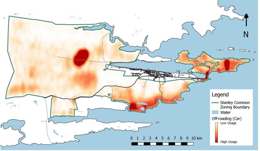
Contents
Abbreviations: ......................................................................................................................................... 4
1.     Introduction: ................................................................................................................................... 6
2.     Background: .................................................................................................................................... 8
     2.1.      Natural Environment: ............................................................................................................. 8
       2.1.1.         Designations:................................................................................................................... 8
       2.1.2.         Environmental Aspects: .................................................................................................. 9
       2.1.3.         Biological Aspects:......................................................................................................... 11
     2.2.      Crown Leases and Grazing Permits: ...................................................................................... 15
     2.3.      Memorials, Monuments, Artistical and Historical Artefacts: ............................................... 17
     2.4.      FIG/Public Infrastructure: ..................................................................................................... 18
       2.4.1.         Road Network and Carparks: ........................................................................................ 18
       2.4.2.         Power Supply: ............................................................................................................... 19
       2.4.3.         Water Supply and drainage: ......................................................................................... 19
       2.4.4.         Fencing: ......................................................................................................................... 19
       2.4.5.         Telecommunications masts and aerials: ....................................................................... 20
       2.4.6.         Navigation Aids to Mariners: ........................................................................................ 20
     2.5.      Shooting Ranges.................................................................................................................... 20
     2.6.      Horse Grazing: ....................................................................................................................... 21
     2.7.      Minefields: ............................................................................................................................ 22
     2.8.      Tourism: ................................................................................................................................ 23
     2.9.      Recreation: ............................................................................................................................ 24
     2.10.        Waste: ............................................................................................................................... 29
     2.11.        Peat Cutting, Sand Extraction etc.: ................................................................................... 29
       2.11.1.        Sand Extraction: ............................................................................................................ 29
       2.11.2.        Peat Cutting: ................................................................................................................. 30
       2.11.3.        Other sediment cover removal: .................................................................................... 31
     2.12.        Category A and B land: ...................................................................................................... 31
3.     Management Objectives: .............................................................................................................. 31
     3.1.      Designations and Natural Habitat: ........................................................................................ 32
     3.2.      Memorials, Monuments, Artistical and historical Artefacts: ................................................ 39
     3.3.      Crown Leases ........................................................................................................................ 39
     3.4.      Shooting Ranges.................................................................................................................... 40
       3.4.1.         Rookery Bay and Phillip’s Point:.................................................................................... 40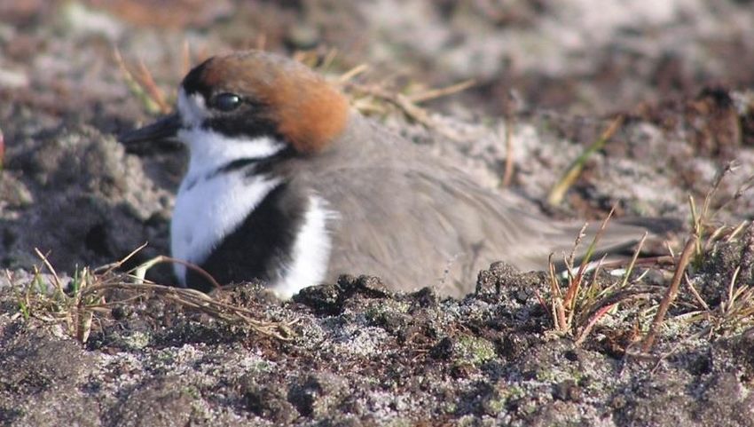
3.4.2.        Kiel Canal Archery Range: ............................................................................................. 41
     3.5.     Peat Cutting, Sand Extraction and other soil extraction ....................................................... 41
       3.5.1.        Peat Cutting: ................................................................................................................. 41
       3.5.2.        Sand Extraction: ............................................................................................................ 42
       3.5.3.        Other soil extraction: .................................................................................................... 42
     3.6.     Tourism ................................................................................................................................. 43
       3.6.1.        Battle Fields:.................................................................................................................. 44
       3.6.2.        Gypsy Cove: ................................................................................................................... 44
       3.6.3.        Rookery Bay: ................................................................................................................. 45
       3.6.4.        Yorke Bay: ..................................................................................................................... 46
     3.7.     Recreation ............................................................................................................................. 47
       3.7.1.        General .......................................................................................................................... 47
       3.7.2.        Dog Walking .................................................................................................................. 48
       3.7.3.        Off-roading .................................................................................................................... 49
       3.7.4.        Fishing ........................................................................................................................... 51
     3.8.     Minefields ............................................................................................................................. 52
     3.9.     Horse Grazing ........................................................................................................................ 53
     3.10.        Animal Burial ..................................................................................................................... 53
     3.11.        Waste Management.......................................................................................................... 56
     3.12.        Category A and B land development: ............................................................................... 56
4.     References .................................................................................................................................... 57
5.     Appendix 1 .................................................................................................................................... 58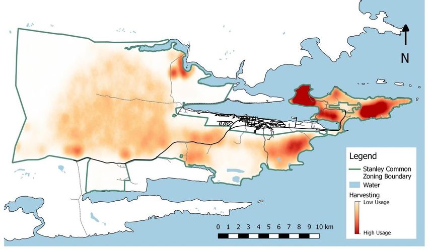
Abbreviations:
DNR                     Department of Natural Resources
DoA                     Department of Agriculture
Environmental The Environmental Officer in FIG’s Policy and
Officer       Economic Development Unit
ExCo          Executive Council
FIDF                    Falkland Islands Defence Force
FIG                     Falkland Islands Government
FIMCo                   Falkland Islands Meat Company
FITB                    Falkland Islands Tourist Board
GLS                     FIG’s Government Legal Services
IPA                     Important Plant Area
MPA                     Mount Pleasant
NNR                     National Nature Reserve
PWD                     Public Works Department
Ordinance               Commons Ordinance 2017
RDA                     Range Danger Area
RFIP                    Royal Falkland Islands Police
TBC                     To be confirmed

List of Figures
Figure 1: A map of Stanley Common showing Category A and B land. .................................................. 7
Figure 2: Dusen's Moonwort................................................................................................................... 8
Figure 3: Cape Pembroke Important Plant Area ..................................................................................... 9
Figure 4: Long-tailed Meadowlark ........................................................................................................ 13
Figure 5: Two-banded plover ................................................................................................................ 14
Figure 6: Gorse at Gypsy Cove .............................................................................................................. 15
Figure 7: Location of all Crown Leases .................................................................................................. 16
Figure 8: Location of all memorials, monuments, etc on Stanley Common ......................................... 18
Figure 9: Location of roads. .................................................................................................................. 19
Figure 10: Location of Navigation Aids ................................................................................................. 20
Figure 11: Location of Range Danger areas .......................................................................................... 21
Figure 12: Horse Grazing Paddocks....................................................................................................... 22
Figure 13: Minefields on Stanley Common ........................................................................................... 23
Figure 14: Passive recreation on Stanley Common as noted by the April/May 2018 consultation.
Colours are relative to the overall area for the activity. Minimum here were 2,419,240 points marked
per 250 m2 to 217,040,000 points. Points are an arbitrary indication for the amount of use. ............ 25
Figure 15: Watersport recreation on Stanley Common as noted by the April/May 2018 consultation.
Colours are relative to the overall area for the activity. Minimum here were 182,835 points marked
per 250 m2 to 19,989,900 points. Points are an arbitrary indication for the amount of use. ............. 26

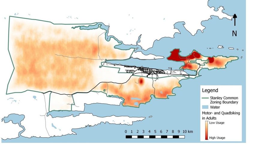
Figure 16: Berry and flower picking (harvesting) on Stanley Common as noted by the April/May 2018
consultation. Colours are relative to the overall area for the activity. Minimum here were 247,976
points marked per 250 m2 to 44,139,700 points. Points are an arbitrary indication for the amount of
use. ........................................................................................................................................................ 26
Figure 17: Dog walking on Stanley Common as noted by the April/May 2018 consultation. Colours
are relative to the overall area for the activity. Minimum here were 94,226 points marked per 250
m2 to 48,526,600 points. Points are an arbitrary indication for the amount of use. .......................... 27
Figure 18: Off-roading in a car on Stanley Common as noted by the April/May 2018 consultation.
Colours are relative to the overall area for the activity. Minimum here were 449,122 points marked
per 250 m2 to 9,880,690 points. Points are an arbitrary indication for the amount of use. ............... 28
Figure 19: Off-roading by adults on a motor or quad bike on Stanley Common as noted by the
April/May 2018 consultation. Colours are relative to the overall area for the activity. Minimum here
were 99,346 points marked per 250 m2 to 13,511,100 points. Points are an arbitrary indication for
the amount of use................................................................................................................................. 28
Figure 20: Off-roading by children on a motor or quad bike on Stanley Common as noted by the
April/May 2018 consultation. Colours are relative to the overall area for the activity. Minimum here
were 0 points marked per 250 m2 to 856,750 points. Points are an arbitrary indication for the
amount of use. ...................................................................................................................................... 29
Figure 21: Sand Extraction Area ............................................................................................................ 30
Figure 22: Areas where peat cutting is still practiced. .......................................................................... 31
1. Introduction:
Stanley Common is an area of public land surrounding the capital of the Falkland Islands, Stanley. As
with most areas of common land, it was set aside for the benefit of the community and to meet its
needs. In recent years the use of Stanley Common has shifted from predominantly grazing
opportunities for people in town to being used for primarily recreational purposes. Use of the
Common has evolved over many years and it is important that we update our policies and legislation
to ensure that this important resource is appropriately managed and protected.

Not only is Stanley Common of importance to the community but also to the natural environment.
The areas of Stanley Common and Cape Pembroke have been designated as a National Nature
Reserve (NNR) since 1973 and Cape Pembroke is an Important Plant Area (IPA) of the Falkland
Islands. Throughout the Common a wide range of native and endemic as well as rare plants and
animals can be found. Wild animals in the Common are protected under the NNR designation.

The Commons Ordinance 2017 was published in the Falkland Islands Gazette on 31st January 2018
(Supplement 1). It has not yet commenced in effect. The Ordinance will provide for the designation
of Stanley Common as Common land and extend its area to the west to include Two Sisters Camp.
The Ordinance also provides for other areas throughout the Islands to be designated as Common
land.

Section 11 of the Ordinance permits the Lands Committee (in consultation with the Environmental
Committee) to make by-laws to regulate the uses of and activities on Stanley Common. For this
purpose, the Common is sub-divided into Category A land and Category B land – as summarised in
section 2.12 below. Bylaws may also be made for the development of any Category B land (see
section 3.12). In addition, the Lands Committee (in consultation with the Environmental Committee)
may develop “guidance on the use of Category A Stanley Common Land and Category B Stanley
Common Land to facilitate the implementation of this Ordinance and any bylaws.” This management
plan is intended to serve the purpose of this guidance and is to be underpinned by by-laws as
referred to in section 11.

This management plan seeks to provide for the pro-active management of Stanley Common with
both the community and natural environment in mind. Its aim is to clearly identify management
actions that embrace a vision for the future of Stanley Common for generations to come.

It is our Community’s vision that:

   “Stanley Common is a place for the Community, accessible to all, for shared opportunities
   and with good infrastructure. It is a place of recreational freedom and activities such as
   walking, cycling, horse riding, dog walking and community sport. Our Common looks to
   provide for conserving and protecting unique wildlife and nature and our heritage and
   culture such as peat cutting and memorials.”

   Stanley Common Workshop, June 2018.
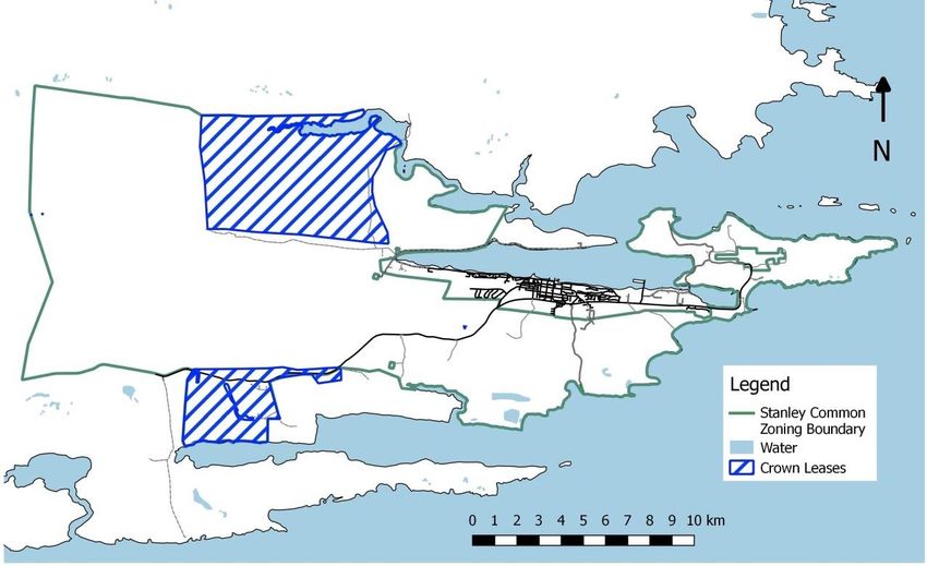
Figure 1: A map of Stanley Common showing Category A and B land.
2. Background:

This section will give an overview of all the existing infrastructure, management activities and
recreational activities on Stanley Common as well as their location. It also seeks to paint a picture of
the natural variety of habitats and landscapes as well as associated flora and fauna on Stanley
Common.

    2.1.        Natural Environment:
Stanley Common is a hugely diverse area and the whole area is a NNR. The area known as Cape
Pembroke is an IPA.

        2.1.1. Designations:
            2.1.1.1.     Common Land:

Stanley Common was declared in 1849 as common land for use of the population of the town in
perpetuity. Common land in this instance is land which is subject to common rights for the benefit of
the community as a whole. The extent of the Common has changed since then but often lacked
definition: “the fenced land bounding Stanley on the south, east and west” in 1963, while the “Cape
Pembroke Peninsula” was added in 1981. Only in 1999 with the passage of the Stanley Common
Ordinance 1999 was the area of land clearly defined.

            2.1.1.2.     National Nature Reserve (NNR)

The whole of Stanley Common was designated as a NNR in 1973 under what was then the Wild
Animals and Birds Protection Order. This has now been adopted under the updated Conservation of
Wildlife and Nature Ordinance 1999. It was intended that the areas known as Stanley Common and
Cape Pembroke Peninsula were to be wild animal and bird sanctuaries. In order to achieve this, any
person who, within the relevant area, wilfully kills, injures or takes any wild animal or bird or
attempts to do so commits an offence under that 1999 Ordinance. This will remain in effect for the
entirety of Stanley Common.

As an NNR, previous management plans encompassed specific areas within Stanley Common,
                                         namely the Murrel River, Gypsy Cove and Yorke
                                         Bay Pond. These were reviewed and included in
                                         this document in their reviewed and revised form.

                                                                2.1.1.3.    Important Plant Area

                                                   Cape Pembroke was classified as meeting the
                                                   criteria for an IPA by Upson (2012). There are 66
                                                   different species of native plant, four species of
                                                   endemic plants and 21 habitat types on Cape
                                                   Pembroke and the IPA covers 923 ha with an

 Figure 2: Dusen's Moonwort                        altitude range of 0-15 m.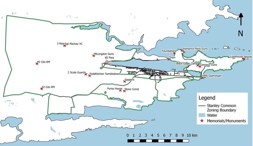
Cape Pembroke was classified (based on IPA Criteria B) for the exceptional botanical richness it
provides. This includes the Neutral grasslands and the Spider Flower (Arachnitis uniflora), a neutral
grassland indicator species, of which there are only around 30 individual examples. “This is the
largest population on record in the Falkland Islands and Cape Pembroke is only one of two known
locations. The number of individuals that flower can vary widely from year to year and it is only the
flower which is visible above ground” (Upson, 2012). Another species categorising the area under
Criteria B is Dusen’s Moonwort (Botrychium dusenii) of which there are over 400 individual fronds
found. This again is a neutral grassland indicator species and is a nationally threatened species. Cape
Pembroke is only one of four areas in the Falklands that support this species. Finally, Cape Pembroke
was also listed for its recovering bluegrass dune grassland habitat under Criteria C.

Figure 3: Cape Pembroke Important Plant Area

         2.1.2. Environmental Aspects:
             2.1.2.1.      Climate:

The climate of Stanley Common is the same as that of Stanley. This is characterised as a maritime
climate in the tundra and sub-polar zones according to the Köppen classification. The climate of
Stanley Common is influenced by the offshoot of the circumpolar current known as the Falklands
Current. As typical of a maritime climate the temperature range is small with average temperatures
between 0˚C and 13˚C. Temperatures are rarely below freezing and seldom exceed 24˚C. At a
latitude of 51˚S, Stanley Common experiences long daylight hours during the summer months of
November to February and short daylight hours in the winter months. The area is notoriously windy
with winds in excess of 18 knots 40% of the time. The wind is prevailingly westerly and the average
wind speed is 16 knots. Stanley Common is probably one of the wettest areas of the Falkland Islands
with about 681 mm of rain a year.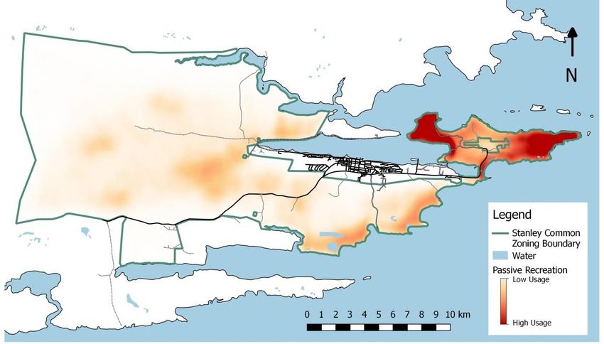
2.1.2.2. Geology:
Stanley Common is part of the Port Stanley formation. The rocks are from the Upper Devonian to
Carboniferous eras and are composed of quartz arenite and subarkosic sandstones. Minor secondary
mineralization led to the development of pyrite. Recrystalisation has also occurred within the rock
between the quartz-grains, which show quartz re-growth around the grains’ surface. This has caused
the porosity and the permeability of some of the beds to be very low. Very small and rarely exposed
pockets of shale may be observed within the formation.
20,000 years ago, the sea level was higher than it is today and there was a raised beach around the
Stanley Area. Cape Pembroke was a separate island and surrounded by cobbles and pebbles on all
shores. As sea levels began to drop, spits began to form and eventually a tombolo formed to join
Cape Pembroke to the mainland. Parts of this tombolo and the wave-formed platform it created are
still visible today. However, the area is now covered in peat and sand.
Even more recently, following the last Ice Age, the environment stabilised and peat formation began.
Peat is now roughly 13,500 years old. Sand was blown in on the Cape Pembroke area forming sand
dunes and vegetation took root to stabilise these. These dunes however, have not been stable
throughout the Islands’ geological past and are very susceptible to small changes in the island’s
climate.
2.1.2.3. Habitat Types
Stanley Common includes almost every single habitat type of the Falkland Islands, from the
mountainous region in the west to the coastal habitats in the east. The coastal habitats around
Stanley Harbour, the south coast and further onto Cape Pembroke consist of some rocky areas with
shingle and some small cliffs verging onto cliff habitats in some regions. In other coastal areas,
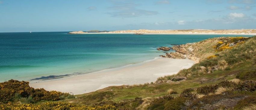
particularly at Surf Bay and Cape Pembroke, sand dune habitats are common. Dunes are often
stabilised by marram grass and other plants such as sea cabbage, stonecrop and sheep’s sorrel.
Finally, in some coastal regions (in particular Hooker’s point and Gypsy Cove), Tussac habitats can be
found. Mainland tussac habitats are one of the most vulnerable habitats on the Islands and so these
areas are “roped” off at Gypsy Cove. Falklands Conservation undertakes regular habitat recovery and
planting exercises of both native blue grass and tussac grass.
Further inland at Cape Pembroke and in the lower-lying areas of Stanley Common there are acid
grassland, dwarf shrub heath and scrub lands. “Acid grasslands are dominated by white grass with
short rush dominating in the wetter regions.” (Liddle, 2007). Grassland habitats are home to some of
our most iconic passerines including the grass-wren, common snipe, black-throated finch and
Falklands thrush. These areas extend into the mountainous regions to the west of Stanley Common
and include inland rock, although some of the higher areas on Cape Pembroke are of this habitat as
well.
Wetlands are also wide spread behind the coastal margins of Stanley Common. These include coastal
greens such as at Whalebone Cove and wet habitats consisting of ponds such as those found along
the south coast and on Cape Pembroke. These wet habitats provide a good habitat for a number of
duck and wading bird species such as the yellow-billed teal, Patagonian crested duck, double-banded
plovers, rufous chested dotterels and Magellanic oyster catchers.Habitat restoration is an on-going project on Stanley Common. Falklands Conservation has led on a
number of projects to restore habitats around the Islands including on the Common. These efforts
have mainly been centred around Cape Pembroke and most notably the eroded areas on the south
coast towards Christina Bay.
2.1.3. Biological Aspects:
2.1.3.1. Protected and Rare Plants
Stanley Common and Cape Pembroke in particular are havens for protected and rare plants on the
Falkland Islands. These are summarised in the table below which includes some key notes about the
Stanley Common populations (according to Liddle, 2007 and Upson, 2011).
Species Known Locations Notes
Spider Flower Yorke Bay Pond and Cape The Cape Pembroke location is one of only
Pembroke two locations on East Falkland where the
flower occurs. This plant is protected under
the Conservation of Wildlife and Nature
Ordinance 1999. On the National Red List
for plants it was scored as endangered on
the threat category.
Dusen’s Yorke Bay Pond and Mary Hill Dusen’s Moonwort is known in only four
Moonwort locations across the Islands and is easily
overlooked in short turf. This plant is
protected under the Conservation of
Wildlife and Nature Ordinance 1999. On the
National Red List for plants, it was scored as
endangered on the threat category
Small Dusky Cape Pembroke This plant is very scarce and native and is
Sedge found in areas of marshy grassland and
pond margins across Cape Pembroke. On
the national red list of plants it was scored
as vulnerable on the threat category.
Sage’s sedge Cape Pembroke This species is a native but not endemic
species and is only currently known at Cape
Pembroke with only one other historical
record at Teal River to Hill Cove made in the
1950s. The current habitat is near a former
quarry and tip site with the habitat
vulnerable to changes in hydrology. On the
National Red List of plants, it was scored as
endangered.
Pale Yellow Cape Pembroke; Yorke Bay Pond The largest population of this plant is found
Orchid at Cape Pembroke where there are over
600 individuals. This species is protected
under the Conservation of Wildlife and
Nature Ordinance 1999 and is listed on theNational Red List for plants as vulnerable.
Adder’s tongue North-end of Surf Bay This plant has fewer than 1000 remaining
individuals on the island and is protected
under the Conservation of Wildlife and
Nature Ordinance 1999. It is listed as
vulnerable on the National Red List for
plants.
Falkland Rock- Wireless Ridge There are currently fewer than 1000
cress specimens remaining on the Islands and
sub-populations are usually found away
from grazing areas and consist of fewer
than 20 individuals. It is protected under
the Conservation of Wildlife and Nature
Ordinance 1999 and listed as vulnerable in
the National Red List for plants.
Yellow Orchid Murrell River This is the tallest of Falklands orchids and
reaches up to 40 cm tall. It is not protected
and not listed on the National Red List for
plants but still identified as rare.
Dog Orchid Gypsy Cove, Yorke Bay Pond, The Dog Orchid is the most common orchid
Whalebone Cove and Phillip’s in the Falkland Islands but difficult to find as
point it only flowers for a short time. It is not
protected and not listed on the National
Red List but is still identified as rare.
Fuegian Arrow Canopus Hill Fuegian Arrow Grass is not listed under the
Grass National Red List nor is it protected.
However, it is still noted as being scarce.
Gaudichaud’s Cape Pembroke and Stanley Gaudichaud’s Orchid is a native plant that
Orchid Airport can be difficult to find and identify, the
flower may not open in dry weather. It is
not listed under the National Red List nor is
it protected. However it is noted as being
scarce.
Other native and endemic plants are wide-spread on Stanley Common. There are a total of 66 native
plants and four endemic species commonly found: Coastal Nassauvia, Lady’s Slipper, Vanilla Daisy
and Woolly Falkland Ragwort.
2.1.3.2. Wildlife
Stanley Common is prized for its wildlife and contains many species native and endemic to the
Falkland Islands. All wildlife on Stanley Common is protected under law including the Upland Goose
and the (usually seasonally exempted) Yellow-Billed Teal and Crested Duck. The coastal areas around
the Common boast a wide array of birdlife and in a recent survey undertaken by Poncet (2014)
counted 26 different bird species on Cape Pembroke in winter and 27 different bird species in
summer, and 23 different species in winter around Stanley Harbour (24 in summer). On average
there are 54 birds/km along the coastline of Cape Pembroke. According to Poncet (2014), this
distribution is made up of a mixture of passerines, waders and some iconic species such as the KelpGoose, Falkland Steamer Duck (Logger Duck), Sooty Shearwaters, Magellanic Penguins and Gentoo
Penguins.
Passerines are small land birds and during Poncet’s survey (2014), seven of the species observed
were native. These were the Falkland
Thrush, Black-Chinned Siskin, Black-
Throated Finch, Tussac Bird, Long-Tailed
Meadowlark, Grass Wren and Falkland
Pipit. These occur along the coastline of
Stanley Common. They are most
common in Stanley itself and on the
south-side of the Canache followed by
Surf Bay. Generally passerines are less
conspicuous in the winter and easier to
detect in the summer when they exhibit
breeding behaviours including singing,
Figure 4: Long-tailed Meadowlark courtships and nest building (Falklands
Conservation, 2011). Tussac birds are
common but mostly on rate free islands; they migrate to the mainland at Cape Pembroke from
nearby rat-free islands. The Falkland Thrush is widespread and found in a variety of habitats,
particularly in areas with ferns and diddle-dee as shelter. Black-Chinned Siskins and Black-Throated
Finches feed on seeds from tussac and diddle-dee and there are distinct differences in male and
female Finches.
Kelp Geese and Upland Geese are also commonly found around Stanley Common and represent
probably some of the most numerous birds (see Poncet, 2014 and Falklands Conservation, 2011).
Kelp Geese are most common at Cape Pembroke and Christina Bay but can be observed anywhere
along the shoreline of Stanley Common (Poncet, 2014). Upland Geese are probably the most
numerous species of wildfowl on Stanley Common and are present year round (Falklands
Conservation, 2011). Other species of waterfowl on Stanley Common include species of ducks and
grebes such as the Speckled Teal, Silver Teal, Flightless Steamer Duck, Patagonian Crested Duck and
White-Tufted Grebe. The ponds on Cape Pembroke and on Philip’s Point provide an excellent
environment for such species. For example, the Silver Teal is found in weed-filled ponds where it
feeds on aquatic vegetation and invertebrates. Most of these species can be found year round
(Falklands Conservation, 2011). The Flightless Steamer Duck, or Logger Duck, is wide-spread on
beaches and in sheltered harbours and creeks.
Wading and shorebirds include the Magellanic and Blackish Oystercatchers, White-Rumped
Sandpiper, Two-Banded Plover and the Rufous Chested Dotterel. The White-Rumped Sandpiper is
migratory and joins the other species in summer and is common on sand beaches and by creeks and
ponds; it feeds on Sandhoppers and other marine invertebrates. Two-Banded Plovers are commonly
found in coastal areas on sand beaches and around creeks and they feed on small invertebrates at
the surf’s edge and in rotting kelp. Rufous-chested dotterel’s will feed on insects, larvae and marineinvertebrates but are at risk from rats and cats taking eggs and chicks. Oyster Catchers are widely
found along rock and sandy beaches.
They feed on limpets and mussels.
Gulls and seabirds are also commonly
found along the shorelines of Stanley
Common with a mixture of Petrels,
Gulls, Cormorants and other seabirds
found along the coast. Amongst these
Kelp and Dolphin Gulls are probably
the most visibly abundant both along
the coastlines of Cape Pembroke and
near the tip at Eliza Cove (Falklands Figure 5: Two-banded plover
Conservation, 2011). Rock
Cormorants are also very common around the coastlines of Stanley Common above the high
watermark where they make nests out of surrounding material. There have been reports of
burrowing Sooty-Shearwaters in respect of burrows found on Cape Pembroke and these are also
commonly seen from nearby islands. However the presence of predatory rodents and cats means
these are less common on the mainland.
Several species of Penguin rest and breed on the shorelines of Stanley Common. Most notably these
are the burrowing Magellanic (Jackass) Penguins which are found in colonies at Rookery Bay and at
Gypsy Cove and Hadassah Bay. Magellanic Penguins begin returning to their burrows each year in
September and begin egg-laying in mid-October (Woods and Woods, 1997). A Gentoo colony is
found at Yorke Bay, however, this is not a breeding colony. The gentoos are found there year-round
and the colony site is currently still located within a minefield fenced area, however, this is due to be
cleared by March 2020.
Stanley Common is home to a range of raptor species with the Turkey Vulture being probably the
most common but other species which are rarer such as the Red-Backed Hawk have also been
reported on Stanley Common. Although it is possible to gain a derogation licence to shoot Turkey
Vultures where livestock is under threat, this is not possible for Stanley Common. Turkey Vultures
are a new world vulture who are carrion feeders. As such they can be found in dense numbers at
Eliza Cove tip and where there is a dead carcass (Strange, 1992). They will roost in trees around
Stanley as well.
2.1.3.3. Non-Native and Invasive Species:
Unfortunately invasive species are common around Stanley Common due to its proximity to Stanley.
Their management is not clear. Invasive are both plant and animal species such as rodents,
mammals and insects. The Biodiversity Framework’s Biosecurity and Invasives Strategy ranked
invasive species according to their threat to biodiversity and invasive potential, based on the outputs
from the South Atlantic Invasive Species Project which classed 261 invasive species found on the
Falkland Islands. This strategy is aimed to “contain and reduce the spread and populations of priority
terrestrial and marine invasive species to minimise their harmful impacts by 2020”. Limited spatial
identification of the location of known invasives is available. Further compiling will be required.Known plant invasives on Stanley Common include but are not limited to Thistles, Calafate and
Gorse. Gorse and Calafate are ranked amongst the most threatening invasive species on the Islands.
Past efforts to control Gorse have been undertaken at Gypsy Cove where Gorse is a threat to the
native Tussac habitat. Some occurrences of Calafate, especially in the montane regions have also
been reported,
though these are
still singular
outlying plants.
Non-native Marram
grass, although not
as high scoring in
terms of
invasiveness, has
considerably added
Figure 6: Gorse at Gypsy Cove to the stabilisation
of the sand dunes
found both at Yorke Bay and Surf Bay. The spread of non-native species should be monitored.
Animal invasives are found across several taxa on Stanley Common including insects, mammals and
occasionally birds. Feral cats have been reported on Cape Pembroke as well as Norwegian Ship Rats.
These are also found closer to Stanley and at the Eliza Cove Tip site. In areas of Stanley Common
closest to Stanley, there have been reports of the non-native European Earwig.
2.2. Crown Leases and Grazing Permits:
At present the following crown leases and grazing licences are held on Stanley Common. These have
specific licence agreements attached to them that outline the responsibilities of the lease holder and
the Crown, duration of the lease and what happens when the site is surrendered at the end of the
lease. The location of all crown leases is shown below:Figure 7: Location of all Crown Leases Crown Lease Number 250: Kuzma Mario Zuvic-Bulic: Crown Lease Number 250 was located near the summit of Mount William where a telecommunications aerial used to sit. This site has now been surrendered although a concrete block remains at the site of the aerial. Crown Lease Number 379: Grazing Licence: Neil Watson: Crown Lease Number 379 is a grazing licence for the area known as Mount Longdon. This area is leased for the sole purpose of grazing sheep, cattle and/or horses and the named lease holder is the late Neil Watson (although the lease is now operated by his beneficiaries). The lease was granted on 25th March 2005. The area covered the grazing licence is managed in accordance with that licence and allows for public access. Crown Lease Number 415: Kuzma Mario Zuvic Bulic: Crown Lease Number 415 is located near the summit of Sapper Hill. This is the location of a communication mast located at Sapper Hill and the lease holder is Kuzma Mario Zuvic Bulic trading as KMZ Electronics. The lease was granted on 14th May 2007 for a period of 25 years from 1st January 2006 to 1st January 2031. Security fences are in place surrounding the site to prevent any accidents. Upon surrender at the end of the lease term, it is the tenant’s responsibility to remove any and all structures erected and to make good any damage caused. Crown Lease Number 416: Kuzma Mario Zuvic Bulic: Crown Lease Number 416 is located near the summit of Sapper Hill. This is the location of a communication mast located at Sapper Hill and the lease holder is Kuzma Mario Zuvic Bulic trading as KMZ Electronics. The lease was granted on 14th May 2007 for a period of 25 years from 1st January 2006 to 1st January 2031. This area is managed in accordance with the lease. Security fences in place
are the responsibility of the tenant. Upon surrender, the tenants have covenanted to remove any
and all structures erected and to make good any damage caused.

Crown Lease Number 418: Grazing Licence:

Crown Lease Number 418 is a grazing licence issued annually to FIMCO for the temporary grazing of
sheep and cattle. The location of this is to the south of the quarry at Pony’s pass. This land is
managed in accordance with the grazing licence and provides for public access.

Crown Lease Number 497: Cable and Wireless South Atlantic Limited:

Crown Lease Number 497 is located to the south-west of Stanley at Sapper Hill. This is the location
for the telecommunications masts located at Sapper Hill and Cable and Wireless South Atlantic
Limited (now known as Sure South Atlantic Limited) is the lease holder. The lease was granted on 6th
of July 2011 and runs for a period of 25 years from 1st March 2008 until 1st March 2033. This area is
managed in accordance with the lease. Upon its surrender, it is the tenant’s responsibility to remove
all structures except concrete hardstanding and make good any damage caused. The location of the
lease is shown in the map below.

Crown Lease Number 579: The Regents of the University of California:

Crown Lease Number 579 is located in the western part of Stanley Common next to the North Camp
road. This lease is the location of the Mount Kent Seismic Station and the lease holders are The
Regents of the University of California. The lease was made on 24th November 2016 between the
Crown and The Regents of the University of California for a period of 10 years until 1 st April 2026,
with the option to extend for a further 10 years. The research permit linked to the seismic station is
R21.2016 with the research permit holder being Dr. Peter Davis at the University of California, San
Diego. This research permit is valid until 31st December 2021 and permits data collection for seismic
activity. The location of this lease is identified in the map below. The land leased is managed in
accordance with the lease. Fencing structures surrounding and on the premises are maintained by
the tenant and should prevent members of the public interfering with the structures. The local
contact is Sure.

    2.3.    Memorials, Monuments and Artistic and Historical
       Artefacts:
Throughout the Common there are a range of memorials, monuments and historical artefacts dating
back to the Falklands Conflict in 1982, the Second World War (1939-1945), the First World War
(1914-1918) and beyond. These hold a special place in the history of the Falkland Islands and in the
community. The map below shows the location of the better known memorials though this list is not
exhaustive and one should recognise the importance that the natural landscape to the west of
Stanley played during the conflict.

Those that wish to erect a new memorial may do so through a written application to the Governor.
This includes the retrospective approval for any memorial existing on the Common given in
accordance with the Stanley Common (Erection of Memorials) Regulations 2014 (which sets out the
relevant requirements).
Figure 8: Location of all memorials, monuments, etc on Stanley Common
In addition to historical memorials, monuments and artefacts, Rob Yssel’s solar system sculptures
are also of importance to the community. These represent all planets in the solar system (including
the Sun and Pluto), placed in proportion to their respective distances. Some of these sculptures are
found on Stanley Common and form a walkable trail. These are to be protected by the Ordinance.
2.4. FIG/Public Infrastructure:
Throughout the Common, various pieces of infrastructure are located. These are all vital to the
public services and utilities provided to Stanley for the benefit of the general public and Stanley’s
safety, and are managed by FIG. These include the road network, car parking, power provision,
water supply and marine safety. These are found predominantly on land designated as Category B
under the Ordinance.
2.4.1. Road Network and Carparks:
The road network is shown on the map below. The maintenance of the roads and the maintenance
schedule are the responsibility of PWD - Roads Section who will decide when and which roads need
to be improved or repaired in the interests of road users and the general public. The map was
produced based on data correct as at June 2018 and shows both surfaced and unsurfaced roads. This
section of the Management plan is included as a sign-post to PWD. The Ordinance states the
construction of the road to the FIDF ammunitions store is permitted by FIG.
Carparks on the Common include the carpark at Mt. Harriet, Gypsy Cove and Cape Pembroke. As
with the road network, the maintenance of these is the responsibility of PWD.Figure 9: Location of roads.
2.4.2. Power Supply:
Approximately 40% of Stanley’s power comes from the wind farm located south of the MPA road at
Sand Bay. At present there are 6 wind turbines, operated by the PWD – Power Section. Here again
this section in the management plan is a sign-post to the Power Section for any issues. The laying of
power cables to the FIDF ammunitions store which is located on Stanley Common is permitted in
accordance with the Ordinance, as is the laying of power cables to the Medium Wave Transmitter on
Mt. William by both FIG and communications providers, and the development of Sapper Hill for the
purpose of the supply of electricity by FIG.
2.4.3. Water Supply and drainage:
There are two catchments which supply Stanley with fresh water. These are located either side of
the Two Sisters. The primary water supply is from Moody Valley with the Murrell River Catchment
area as an alternate water supply. The development of Moody Valley and the Murrell River
Catchment area by FIG for the purpose of supplying and preserving the supply of water to the town
of Stanley is permitted under the Ordinance.
Trenching is common on Stanley Common especially where needed for infrastructural needs. An
exact map or location of trenches is not available nor is the extent of trenches.
2.4.4. Fencing:
The responsibility of fencing on Stanley Common is shared amongst 4 different FIG departments:
DoA, Environmental Officer, FIDF and the PWD. The DoA is responsible for maintenance of fencing
around horse grazing paddocks and holds the relevant budget for this. The Environmental Officer is
responsible for some of the fencing at Cape Pembroke (in particular the fence line from Gypsy Cove
to Hadassah Bay and at the lighthouse on Cape Pembroke). This is to prevent grazing of these areas.
FIDF holds the contract for all fencing around minefields and its maintenance. Unfortunately theprecise locations of all minefield fences are not known but they are assumed to surround each
minefield. PWD is responsible for any boundary fencing of Stanley Common. Where management
actions are required these are addressed separately in this management plan.
2.4.5. Telecommunications masts and aerials:
The majority of telecommunications masts and aerials found on Stanley Common are on leased land
and found at Sapper Hill. However, some exceptions exist - the radio mast located between Mount
William and Mount Tumbledown and the mast at Christina Bay. Both of these are maintained by
KMZ Electronics Ltd. The aerial mast is FIG-owned.
2.4.6. Navigation Aids to Mariners:
At present there are two navigation aids located on Stanley Common. These are found at Cape
Pembroke and Navy Point indicated in the map below. The maintenance and upkeep of these are
the responsibility of the FIG DNR – Fisheries (contact - the Harbour Master). This includes the fencing
surrounding the light at Cape Pembroke.
Figure 10: Location of Navigation Aids
2.5. Shooting Ranges
Three main ranges are found on Stanley common. The Archery range straddles the Common
Boundary on Kiel Canal. The shooting range at Philip’s Point and Rookery Bay are entirely on Stanley
Common. The ranges are used by FIDF and the RFIP. Furthermore, the ranges are used by a number
of clubs including the Gun Club, Rifle Club, Archery Club and Shotgun Club. This is captured under
the Ordinance as “Rookery Bay Rifle Range, Phillips Point gun Range and the Kiel Canal Road Archery
Range” as areas for recreational target practice under the supervision of clubs formed for the
purpose.Safety is a key priority on these ranges, not just for those involved in target practice activities but for
the wider general public using the area for recreational practice. The Archery range on Kiel Canal
Road is fenced off and uses clear flag signals to show when the range is in use. The range danger
area (RDA) here is very limited but range safety cover is usually provided. This is in line with best
practice principles. Safety is also a key priority for the users of the other two ranges. Historically
these ranges had RDAs which were predominantly in minefield areas that were closed off to the
general public. As minefields have been cleared, a clear plan and direction are now needed to
maintain public safety.
Figure 11: Location of Range Danger areas
2.6. Horse Grazing:
There has been a long history of horse grazing on Stanley Common with horses usually owned by
residents in Stanley allowed to graze on Stanley Common. Horse grazing on Stanley Common has
been historically managed by the DoA with permits issued under the Stanley Common Ordinance
1999. Grazing permits were available for the summer season, winter season or entire year with
permit fees charged accordingly. Grazing is rotational and uses 6 different paddocks across the
Common. Annual grazing rotations vary across Stanley Common with winter grazing usually on the
Cape Pembroke peninsula. Due to the limited amount of feed available on the Cape Pembroke
peninsula, maximum grazing numbers have been set in the past.
Though horse grazing is controlled on Stanley Common, horse riding is not and is popular amongst
horse owners, particularly in the areas shown on the map below.Figure 12: Horse Grazing Paddocks
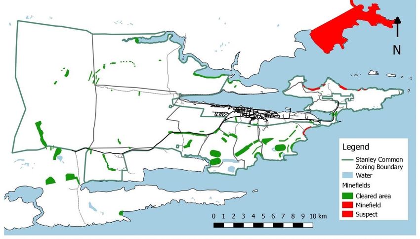
2.7. Minefields:
Following the 1982 Falkland Islands Conflict, 122 minefields and 7 suspect areas were left. The
majority, approximately 90, of these minefields were found in the vicinity of Stanley and on Stanley
Common. Since 2009 these minefields have been gradually cleared with only the minefields at
Rookery Bay and Yorke Bay remaining. All these minefields are due to be cleared by summer
2019/2020. Minefields and their clearance status (correct as at October 2018) are identified on the
map below. The clearance of the remaining minefields on Stanley Common at Yorke Bay and
Rookery Bay is imminent and so appropriate management actions for the future of these minefields
is necessary to ensure their ability to recover from demining activities and that wildlife at these sites
is suitably protected. Past demining activities have meant that gradually other former minefield sites
are becoming accessible to the public as well.
During demining, mines are identified through “cutting in” on a known minefield site. This means
that during this the top layer of ground and all vegetation is removed and checked for signs of
mines. Following this, once mines are found, a similar method is used to follow the mine line,
checking along this for any mines and further digging up the ground and any vegetation found.
Though these activities disturb the natural habitat, they are necessary to ensure human safety is
preserved and to release Stanley Common land for public use.
In cleared minefields, ExCo paper 193/13 agreed that minefield fences should be kept around
recently cleared minefields. This was to prevent undue disturbance, such as any off-roading and
excessive grazing, allowing the minefields to recover gradually. However, once a minefield is cleared
and declared as such, it is safe for the general public to enter. It was agreed to monitor habitat
recovery twice a year in each of the minefields to ascertain as to when a minefield has recovered
sufficiently for the fence to be taken down. To assess this activity (which would take a considerable
amount of time away from core activities), a Masters student from the University of the Redlands
was tasked with developing an automated method for identifying the rate of recovery in eachminefield.
Figure 13: Minefields on Stanley Common
2.8. Tourism:
The Falkland Islands received approximately 62,000 cruise ship- and land-based tourists in 2017
(Tourism Statistics, 2017). The majority of these tourists visit Stanley and approximately half will visit
sites around Stanley Common either for their historic or natural significance. At present tourists
visiting Stanley Common are offered guided battle field tours, trips to see penguins, guided nature
trips and of course self-guided tours and walks. There are typically three different types of
“destination”: the hilly areas to the west of Stanley, penguin colonies and the wider Common (if on a
self-guided or guided nature trek).
Battlefield tours take place in areas of historic significance and battlefields from the 1982 conflict.
These tours take place to the west of Stanley in the “hilly” parts of Stanley Common. Routes do vary
between different tour operators. However, these tours provide a significant cultural benefit to the
Islands by educating visitors on their history. These types of tours are booked by cruise ship
passengers and also by land-based tourists and for historic visiting purposes.
At the date of this Management Plan trips to see penguins on Stanley Common are usually to Gypsy
Cove. Gypsy Cove, its infrastructure and wardens, are currently managed through the Environmental
Officer at the site. Gypsy Cove has a maintained circular path about 1 km long. The path to Gypsy
Cove itself is fenced off to the west and east as this is where penguin burrows are located. The path
borders the minefield fence to the east. At Gypsy Cove, the path is only fenced off to the east to
prevent access into Gypsy Cove itself where there are more burrows and, potentially, mines. On
busy days (>500 cruise ship passengers) wardens are employed to monitor and manage the
interactions between visitors and the general public. At present wardens are employed such that on
days when there are:-- Between 500 and 1000 passengers, there are 2 wardens;
- between 1000 and 2000 passengers, there are 3 wardens; and
- over 2000 passengers there are 4 wardens.
Wardens are asked to ensure that people do not stray off the path both for the visitor’s safety but
also for the sake of the wildlife. It is the aim of site management at Gypsy Cove to ensure that
visitors do not have a negative impact on wildlife and that wildlife can continue to thrive at this site.
In addition to wardens and maintaining infrastructure, Gypsy Cove is the only visitor site on Stanley
Common where public toilets are available on cruise ship days. These are operated and maintained
by FITB. However, planning permission exists to develop a permanent unit on a site adjacent to the
carpark at Gypsy Cove. A small car park exists to the west of the site entrance. Gypsy Cove is also
non-smoking and bins are in place here to prevent littering.
Mine clearance activities are likely to result in additional penguin colonies, currently within
minefields becoming new popular visitor sites. This includes Rookery Bay where Magellanic Penguins
are found and Yorke Bay where there are Gentoo Penguins behind the minefield line. Tours may also
stop en-route to a site to show visitors when wildlife has come up to rest or moult in various
locations.
Both guided and self-guided nature treks are available to visitors to the Islands, offering a range of
areas forming part of Stanley Common. Nature treks guided by guides are varied in where they go.
However, they usually end at a more popular tourist site such as Gypsy Cove and have a focus on the
natural environment. Popular walks described in leaflets enable tourists and visitors as well as locals
to self-guide themselves along these routes. Often there are no waymarkers, merely a guide in the
booklet as to where popular points of reference are.
2.9. Recreation:
Recreational use is the most prevalent use of Stanley Common today. Stanley Common is
understood to be a largely recreational area which supports a wide range of activities. To better
understand the spread of the recreational use of Stanley Common, a survey was conducted in
April/May 2018 by the Policy and Economic Development Unit. This survey had 230 responses from
across the community, marking 28 different types of recreational activity. The results and comments
from this survey were then used to develop management recommendations which were taken to a
community workshop in June 2018. The recommendations for management actions were thus
developed and are reflected the management actions included in this management plan. It should
be noted that at the time of the writing of this management plan, Rookery Bay and Yorke Bay were
still mined and so not open for recreational activities.
Activities such as wildlife watching, walking, running, playing, picnicking, photography, cycling,
conservation, beach-combing and camping were grouped together as passive activities. These are
activities that generally leave no trace or may even improve the environment and our understandingof it. The activities on the Cape Pembroke peninsula, along the southern coastline and on the hills to
the west of Stanley gave rise to the highest response rate.
Also included amongst these activities is the model aircraft club’s landing strip which is located south
of the bypass on Stanley Common. This management plan recognises this site for the model aircraft
club.
Figure 14: Passive recreation on Stanley Common as noted by the April/May 2018 consultation. Colours are relative to
2
the overall area for the activity. Minimum here were 2,419,240 points marked per 250 m to 217,040,000 points. Points
are an arbitrary indication for the amount of use.
Water sports activities are dependent to some extent on Stanley Common with the surrounding
shoreline used as a point from which to launch boats or as a basis for activities, including swimming,
surfing and fishing. These activities mostly take place on the Murrell River to the west of the
causeway and Drunken Rock Pass. Also strongly marked are the Mullet Creek area and the area
around Surf Bay as well as the coastline of the Cape Pembroke Peninsula.Figure 15: Watersport recreation on Stanley Common as noted by the April/May 2018 consultation. Colours are relative to the overall area for the activity. Minimum here were 182,835 points marked per 250 m2 to 19,989,900 points. Points are an arbitrary indication for the amount of use. Flower and berry picking also form a particular past time when berries or flowers are in season. The strongest response rates related to the Cape Pembroke peninsula, areas where the shooting ranges are located and to some extent, the hills to the west of Stanley. Generally berry and flower picking is at a low level on Stanley Common and does not present a risk to the environment at present intensity. Figure 16: Berry and flower picking (harvesting) on Stanley Common as noted by the April/May 2018 consultation. Colours are relative to the overall area for the activity. Minimum here were 247,976 points marked per 250 m2 to 44,139,700 points. Points are an arbitrary indication for the amount of use.
You can also read