REVIEW OF THE LAND INFORMATION NEW ZEALAND - (LINZ) PERFORMANCE IMPROVEMENT FRAMEWORK
←
→
Page content transcription
If your browser does not render page correctly, please read the page content below
Performance Improvement Framework

Review of the
Land Information New Zealand
(LINZ)

August 2013

State Services Commission, the Treasury and the Department of the Prime
Minister and Cabinet
Lead Reviewers’ Acknowledgement
As Lead Reviewers for this Performance Improvement Framework (PIF) Review for Land Information
New Zealand (LINZ) we would like to acknowledge the exceptional standard of engagement by LINZ
staff and the Senior Leadership Team (SLT). In addition, we had considerable input from a cross
section of LINZ’s external partners and stakeholders, who were equally committed to building
stronger collaboration in the future. We also had the benefit of considered input from officials from
the Department of the Prime Minister and Cabinet, the State Services Commission and the Treasury.
We are indebted to Kevin Allan, the Performance Review Manager for this PIF, who once again
provided professional guidance, insight and challenge.
LINZ actively engaged with us to identify performance improvements. There was open and energetic
engagement in the process and we note that, even as we undertook the assessment, SLT began to
build on the opportunities we were discussing. This bodes well for the future of location-based
infrastructure in New Zealand.
Performance Improvement Framework
Review: Land Information New Zealand
State Services Commission, the Treasury, and the Department of the Prime Minister and Cabinet
Wellington, New Zealand
Published August 2013
ISBN 978-0-478-40961-1
Web address: www.ssc.govt.nz/pif
Crown copyright 2013
Copyright/terms of use
This work is licensed under the Creative Commons Attribution-Non commercial-No Derivative Works 3.0
New Zealand licence. [In essence, you are free to copy and distribute the work (including in other media and formats)
for non-commercial purposes, as long as you attribute the work to the Crown, do not adapt the work and abide by the
other licence terms.] To view a copy of this licence, visit http://creativecommons.org/licenses/by-nc-nd/3.0/nz/.
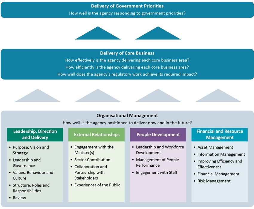
Attribution to the Crown should be in written form and not by reproduction of any such emblem, logo or Coat of Arms.Table of Contents Agency Context___________________________________________________________________2 Performance Improvement Story so Far_______________________________________________3 Agency’s Response________________________________________________________________4 Four-year Excellence Horizon________________________________________________________6 Central Agencies’ Overview________________________________________________________15 Summary of Ratings______________________________________________________________16 Results Section__________________________________________________________________18 Part One: Delivery of Government Priorities_________________________________________18 Part Two: Delivery of Core Business_______________________________________________26 Organisational Management Section_________________________________________________34 Part One: Leadership, Direction and Delivery________________________________________34 Part Two: External Relationships __________________________________________________39 Part Three: People Development _________________________________________________43 Part Four: Financial and Resource Management _____________________________________46 Appendix A _____________________________________________________________________53 Overview of the Model_________________________________________________________53 Lead Questions________________________________________________________________54 Appendix B_____________________________________________________________________55 List of Interviews______________________________________________________________55 Performance improvement framework: Review of the Land Information New Zealand – August 2013 1
Agency Context
Land Information New Zealand (LINZ) is focused on delivering three outcomes for New Zealanders:
• maintaining the integrity of the property rights system to encourage trade, commerce and
  wellbeing
• increasing the productive use of location-based information
• enabling appropriate economic, environmental and recreational uses of Crown-owned and used
  land.
The broad range of activities undertaken by LINZ are summarised below.
Management of property rights: Administering New Zealand’s survey and title system, which is the
basis of the country’s property rights market and is critical to the ongoing functioning of the economy.
It helps ensure confidence in property rights through facilitating the sale, purchase and development
of property at a reasonable cost to users. Its other property rights-related roles include regulating
property rating valuation for local government and administering New Zealand’s overseas investment
regime.
Management of location-based information: Managing and developing datasets of core location-
based information and making them available to others to reuse. This includes providing topographic,
hydrographic, geodetic, addressing, cadastral, and title information as maps and charts and in other
formats. It also administers place-naming rights through the New Zealand Geographic Board, Ngā
Pou Taunaha o Aotearoa.
Management of Crown land: LINZ manages eight percent of New Zealand’s land area that consists of
more than 5,000 properties ranging from South Island high country pastoral leases, to riverbed land
and lakebeds, to major sites such as the Waihi gold mine, and Crown forestry licences. It is also
preparing to manage up to 8,000 suburban properties in Christchurch’s red zone. LINZ regulates the
acquisition and disposal of land by all Crown agencies. Many of these transactions are vital to the
development of New Zealand’s national infrastructure.
In addition, LINZ contributes to a range of cross-government groups. It leads implementation of
New Zealand’s Geospatial Strategy and the Open Government Data and Information Programme and
contributes to the natural resources, urban and Treaty settlement sectors.
LINZ is funded through Vote Lands and supports three Ministerial portfolios, primarily Land
Information. It has approximately 430 staff in offices in Wellington, Christchurch and Hamilton,
including four statutory officers (the Commissioner of Crown Lands, Registrar-General of Land,
Surveyor-General and Valuer-General) and a high proportion of technical staff.
The 2012/13 appropriation for Vote Lands is approximately $140 million. Nearly 60% of revenue is
from customer fees. LINZ manages departmental assets valued at approximately $39 million and
non-departmental assets at $416 million (as at June 2012).
Strategic focus areas identified in LINZ’s current Statement of Intent are: maintaining a wide range of
high quality services in an environment of ongoing fiscal constraint, improving its ability to influence
key stakeholders to achieve collective results and pursuing new initiatives to increase the value and
quality of its services.

2                Performance improvement framework: Review of the Land Information New Zealand – August 2013
Performance Improvement story so far
LINZ was included in the first group of agencies participating in the Performance Improvement
Framework in 2010. At the time of the initial PIF, LINZ was an agency in transition. Having achieved
a world-first milestone of 100% electronic lodgement for land transactions, LINZ began a transition
to emphasise other activities, particularly geospatial information and its potential to have a greater
impact on New Zealand’s productivity.
The 2010 PIF Review found that LINZ’s core business was operating well and it was seen as a
responsive, technically competent and focused organisation. However, the challenge for LINZ was
how it would maintain performance levels while it responded to:
• changing customer expectations (about the type of data available and its accessibility)
• its leadership role to implement the Government’s Geospatial Strategy. The organisational
  implications that the Geospatial Strategy might have on LINZ was far from certain as the strategic
  plan was still in a nascent stage.
In response to the PIF Review the LINZ Action Plan undertook to:
• establish a stronger influence over the use and reuse of New Zealand’s geospatial information
• drive improved customer experiences
• align LINZ people, culture and capability to support its strategic direction.
The Action Plan included work to improve how LINZ prioritises and evaluates activities and ensures
a strong and continued focus on efficiency.
In 2011, LINZ was one of the first agencies to undergo a PIF Follow-up Review, which looked back at
LINZ’s progress towards its stated performance improvement goals. This Review found LINZ:
• had made good progress in engaging with staff to refresh and embed the strategic direction
• has worked on its geospatial leadership
• has made steady progress in implementing the first phase of the Customer Strategy, albeit with
  some disruption due to the Christchurch earthquakes.
This 2013 PIF finds an agency that has continued to build on its past strengths. It has improved its
responsiveness to customers and it has made significant gains in its organisational capability,
demonstrating strong staff engagement, particularly to its strategic direction. While these are
significant gains, this Review also finds an agency that has struggled in the intervening period to
make sufficient traction on the Geospatial Strategy. LINZ stakeholders and staff are inviting it to take
a leadership position to advance this critical growth opportunity for New Zealand. To meet this
performance challenge LINZ will need to significantly evolve its business strategy and operating
model to capture the economic, social, cultural and environmental gains available to New Zealand.
It will also need to ensure staff are positively engaged in what will inevitably be a refreshed strategic
direction.
This 2013 PIF Review presents a Ten-year Excellence Horizon, rather than the usual Four-year horizon,
owing to the infrastructure nature of LINZ’s business. Nevertheless it is vital LINZ acts urgently to
operationalise an infrastructure plan ensuring that key infrastructure building blocks and early
outcomes are delivered by the PIF Follow-up Review, scheduled for mid-2014.

Performance improvement framework: Review of the Land Information New Zealand – August 2013            3
Agency’s response

Introduction
This is our second full PIF Review. We appreciate the opportunity the PIF Review has provided to
reflect on the contribution New Zealand needs from LINZ and, therefore, what our performance
challenge is.
We agree we must add value at the all-of-government level, partnering with local government and
the private sector, and are excited by the opportunity this presents for LINZ. We have a strong
platform to lead from, however, we acknowledge it is unlikely that our performance challenge can
be met by simply doing more of the same or through incremental improvements within a ‘business-
as-usual’ frame.
We have an opportunity right now to seize the challenge of being a strategic leader, driving an
ambitious land information strategy. We accept this challenge and are committed to actively
progressing a work programme to make this a reality.

Acknowledgements
We would like to acknowledge the engagement process undertaken by the Lead Reviewers (Paula
Rebstock and Brian Harrison), who both challenged our thinking and provided thoughtful insights, as
well as the proactive conversations between the Lead Reviewers, LINZ, and our partners and
stakeholders regarding LINZ’s performance challenge.

Our ten-year view
We are exploring and identifying the core components of our performance challenges and how we
can best respond to these over the next 10 years. We have chosen a ten-year period because of the
infrastructural nature of the location-based information (geospatial) part of our business. This
exploration work is the basis of our developing ten-year view, which we expect to complete by
September 2013. This will articulate our motivating sense of purpose and demonstrate the economic,
social, environmental and cultural value to be captured from a spatially enabled New Zealand.
In developing, and then implementing, our ten-year view, we will work collaboratively with our
strategic partners, in particular local government and the private sector. We are committed to
stronger, more strategic and closer relationships with our stakeholders and partners. This will be an
integral part of our modus operandi; we will not step away from this shift and will seek to both lift
our leadership role, as well as develop a partnership approach. We will focus and position our ten-
year view in the context of investments being made by our key strategic partners.

Our Four-year Excellence Horizon
From our ten-year view we will develop a Four-year Excellence Horizon identifying what we need to
achieve in the next four years to progress our longer-term view. This will be informed and made richer
by a number of issues discussed in the Four-year Excellence Horizon section of this Review, including:
• the Government’s and Minister’s priorities and the Government’s outcomes, such as safe
  communities, improved health, employment and growth, environmental, cultural and recreational
  outcomes

4                Performance improvement framework: Review of the Land Information New Zealand – August 2013
• leveraging our property rights, location-based information and Crown land management functions
• the opportunity to lead the development of location-based infrastructure to enable the capture
  of an estimated $500 million benefits from a spatially enabled New Zealand.

Implementing our Four-year Excellence Horizon
By October 2013, we will develop a high-level Action Plan as our road map for the implementation
of our Four-year Excellence Horizon. This Action Plan will be the basis of our upcoming triennial
Statement of Intent and Four-year Plan required by the Treasury. This Action Plan will include the
following practical steps to realise our Four-year Excellence Horizon:
• review existing organisational building blocks: ie, our business strategy, outcomes framework
  (and associated performance measurement framework) operating model and ‘Our Place’ and
  other enabling strategies, eg, People Strategy
• confirm our future work programmes ie, the work we will need to undertake and the performance
  measures we will use to demonstrate success (the impact of our work)
• initiate business improvement initiatives relevant to the findings of the Review: ie, develop
  the necessary processes to ensure we realise the benefits of our work, undertake continuous
  improvement, and adopt a whole-of-organisation approach to evaluation and review.
Our future work programme will continue developing our leadership role around location-based
information, not only through our New Zealand Geospatial Office but by taking a stewardship role in
fundamental data, for example, our recent decision to invest in a national coordinative approach to
New Zealand’s imagery (aerial and satellite photography) and its distribution. The pace of change in
this part of our business is fast, as it needs to keep pace with technological change and the changing
expectations of our stakeholders. We will therefore work closely with stakeholders and Ministers to
determine the optimal approach. When developing our work programme we will simultaneously
focus on moving quickly to respond where opportunities present or where focused effort will
generate gain for our stakeholders and users of land information.
We will achieve our Action Plan in the context of maintaining our solid performance in core business.

Conclusion
We are confident the pre-conditions exist (an engaged and highly skilled workforce and solid
performance in our core business) to enable us to make the shifts described in the Four-year
Excellence Horizon section of the Review and to both develop and achieve a bold ten-year view that
will make the ‘biggest difference’ to New Zealanders that LINZ can. We are also confident we are
putting in place appropriate and timely mechanisms to achieve our Four-year Excellence Horizon,
which is the foundation of our ten-year view. The PIF Review has made a significant contribution
towards helping us achieve this outcome.

Performance improvement framework: Review of the Land Information New Zealand – August 2013         5
Four-YEAR EXCELLENCE HORIZON
In undertaking this Review the Lead Reviewers considered: “What is the contribution that New Zealand
needs from LINZ and, therefore, what is the performance challenge?”
Note: The excellence horizon described in PIF Reviews is usually four years. In this case the Four-year
Excellence Horizon needs to align with the ten-year period the LINZ leadership team is using in
developing its strategic direction and to emphasise the need for LINZ to adopt a longer-term horizon
in leading the New Zealand Geospatial Strategy. It is vital that LINZ acts with urgency to operationalise
an infrastructure plan that ensures that key infrastructure building blocks and early outcomes are
delivered by the PIF Follow-up Review, scheduled for mid-2014.

Environment
The aftermath of the global financial crisis and the Canterbury earthquakes continues to shape the
environment in which government agencies, such as LINZ, operate.
Ongoing fiscal constraint, and the demand for better public services and more focused regulatory
oversight, are likely to be features of the environment for a considerable period.
As a consequence of these factors central and local government and the private sector, both
domestically and internationally, strive to improve the delivery of services and infrastructure in
better, more cost-efficient ways. A key emerging tool is the use of location-based (geospatial)
information1, the technical development of which has led to its increasing importance in planning
and decision-making. In addition to these applications, New Zealand has a number of pressing
challenges that location-based information can assist with, such as climate change, biosecurity and
increased demand for health, education and welfare spending as the population ages.
Overall, there are increasing expectations that location-based information is readily accessible so it
can be used to unlock other economic, social, environmental and cultural benefits. LINZ took some
bold steps a decade ago with the development of Landonline, a world class property rights system
but must now be at the vanguard to ensure we have more comprehensive, nationally available
location-based infrastructure and freer access to location data to realise the benefits available going
forward.
On a different front, as industry and agriculture experience the ongoing fall out of world economic
conditions, the public will continue to seek assurances that the Overseas Investment Act 2005 is
protecting New Zealand’s long-term interests through the operation of the Overseas Investment Office.

The Performance Challenge – Outcomes
The challenge facing LINZ is to respond to the demands and opportunities inherent in this
environment. Its opportunity is to lead the development of the location-based infrastructure needed
to enable the capture of an estimated $500 million of as yet unrealised economic, social, environmental
and cultural benefits from a spatially enabled New Zealand2. Despite having a strong platform to lead
from, it is unlikely that LINZ’s performance challenge can be met by simply doing more of the same
or through incremental improvements to its current business strategy and operating model. The

1 The term location-based information is used in this report to refer to the location and names of features beneath, on or above the surface of the
  earth and the relationship between features. A fuller description is provided on page 18 in the section on Government Priority 1.
2 ACIL Tasman Report 2009.

6                        Performance improvement framework: Review of the Land Information New Zealand – August 2013
Senior Leadership Team (SLT) must now add value at the all-of-government level, partnering with
local government and the private sector. Failure to do so poses risks to the organisation but also
substantial lost or delayed opportunity for New Zealand.
LINZ is tasked with overseeing the policy framework that supports the New Zealand Geospatial
Strategy. It has two roles – to provide leadership of the Strategy (through the New Zealand Geospatial
Office) and to be a centre of excellence. Better use of location-based information can significantly
improve private and public sector efficiency through better decision-making and resource allocation
leading to sustainable development and increased economic, social, environmental and cultural
benefits.
In the future, location-based information and infrastructure will underpin much of the government
planning and decision-making to provide improved services, safe communities, strong economic
growth and sustainable development. Better decisions on health, education, transport, the
environment, etc, will be made earlier in a spatially enabled environment. Currently, many
New Zealand location-based applications are one off, however, nationally integrated applications are
necessary to get the full benefit of a spatially enabled system. To achieve these benefits, a collaborative
approach to the capture, structure, maintenance and use of location-based data is required. Further,
central and local government and industry must both collaborate and co-invest to enable and
develop the infrastructure necessary to underpin these outcomes. This will only happen if a medium-
term, ten-year location-based infrastructure strategy is led credibly and effectively. There will be a
need to demonstrate pace and the value to be gained through geospatial infrastructure.
LINZ should adopt the outcomes of major users of geospatial infrastructure and location-based
information, as well as its own outcomes, as a starting point to develop a coherent, optimised
infrastructure strategy and plan. Many central government agencies have well specified outcomes
as a result of Better Public Services initiatives and the Business Growth Agenda. This should assist
LINZ to prioritise its actions for short-term impact.
To gain momentum and credibility, there are a number of initiatives aimed at intermediate outcomes,
already identified or under way, that create a good starting place for a location-based infrastructure
strategy, including:
• progressing stewardship and custodian arrangements to develop the 10 fundamental data themes
  identified as underpinning the Geospatial Strategy and, specifically, focusing on the following
  LINZ dataset initiatives:
   −− standardising addresses
   −− coordinating aerial imagery procurement access and standards
   −− replacing the Landonline property rights system and improving the digital cadastre and
      geodetic system
• the Oceans Survey 20/20 and mapping initiative
• creating and improving the Canterbury Spatial Data Infrastructure (SDI) which will be used to help
  shape the national SDI
• the LINZ Data Service – providing free online access to 40 LINZ databases
• assisting Auckland in development of its spatial plan
• implementing LINZ’s Crown Land Centre of Expertise and Better Property Services initiatives.

Performance improvement framework: Review of the Land Information New Zealand – August 2013              7
Performance Challenge – Organisation To realise these opportunities, LINZ needs to shift from being a quiet achiever in the land information and property rights to a strategic leader driving an ambitious location-based infrastructure strategy. It needs to articulate a motivating sense of purpose that demonstrates the economic, social, environmental and cultural value to be captured from a spatially enabled New Zealand. Its business strategy and operating model must bring this purpose to life in ways that generate pace and confidence and therefore commitment from key stakeholders. i. Purpose and Targets LINZ currently states its purpose is to “maintain and build confidence in property rights in land and geographic information and encourage land information markets to develop and mature”. Internally, it encapsulates its strategic direction in ‘Our Place – Making a great place’, a concept for which it was a finalist for an Institute of Public Administration New Zealand innovation award. It has also specified three core outcome areas: integrity of the property rights system maintained to encourage trade, commerce and wellbeing; increasing the productive use of New Zealand location-based information; and enable appropriate economic, environmental and recreational use of Crown-owned and -used land. ‘Our Place’ has been embedded in leadership and staff performance plans and supported by LINZ’s internal culture and engagement strategy. Nevertheless, LINZ’s SLT is aware it has struggled to articulate its vision and strategic direction to staff, external stakeholders and partners in a manner that is memorable, unifying, motivating and differentiating. Many stakeholders question if this is because LINZ itself has not grasped the potential contribution to New Zealand of location-based infrastructure and has therefore failed to stake out the leadership role needed. In addition, LINZ has traditionally taken a more technical and operationally focused view of its work and, as a consequence, has tended to focus on its role contributing to intermediate outcomes rather than the outcomes that location-based infrastructure needs to enable: safer communities, improved health, employment and growth, environmental, cultural and recreational outcomes. LINZ is currently working on its ten-year strategy and better framing of its purpose and strategic direction. It recognises that ‘Our Place’ needs to be refreshed and taken to another level. In doing this it is vital LINZ identifies and articulates the impacts it seeks to achieve, as well as the interdependencies with the private sector and local and central government agencies. LINZ needs a coherent, unifying, differentiating and motivating purpose – ie, it must decide what it needs to be in ten years’ time and what it will do at pace to demonstrate impact over the next four years. A ten-year timeframe is necessary, given the high fixed costs and long lead times needed to build location-based infrastructure. The purpose needs to be communicated in a memorable way – that the benefits of a spatially enabled New Zealand are economic, social, environmental and cultural. Each person in the organisation needs to have a direct line of sight between what they do every day and the contribution this makes to real outcomes. Clear targets and a system for managing performance against these are essential to bring LINZ’s purpose to life. It would also help to be clear about priorities and what to stop doing; creating a sense of urgency and the need to deliver for a bigger purpose. A likely central target is the estimated $500 million economic, social, environmental and cultural benefit that would result from a spatially enabled New Zealand. This in turn would need to be anchored in meaningful and measurable sub goals, which frame expectations over the next four years. 8 Performance improvement framework: Review of the Land Information New Zealand – August 2013
ii. Business Strategy
The business strategy describes what the organisation needs to do to meet the expectations of its
stakeholders. LINZ needs to think about this in at least two ways:
• building on its comparative advantage by developing a deep understanding of property rights
  systems, land information markets and location-based infrastructure assets, particularly in the
  New Zealand context
• developing a ten-year strategy and location-based infrastructure plan that will deliver against the
  expectations of stakeholders through time, including demonstrating impact over the next four
  years.
The following criteria are likely to be relevant in shaping the ten-year strategy and infrastructure plan:
• in sum, the components of the strategy and plan are large enough to comfortably achieve the top-
  down target of enabling $500 million of economic, social, environmental and cultural benefits to
  be leveraged from the infrastructure by 2023
• the strategy and plan are built on a solid understanding of initiatives that other major partners3,
  as well as LINZ itself, are planning to invest in and that need to be enabled by location-based
  infrastructure. The initiatives will have a range of time profiles critical to understand and prioritise.
  Some will demonstrate impact over the next four years
• the strategy will include a range of best practice and business-as-usual core activities, ensuring
  LINZ’s key operating platforms continue to be fit-for-purpose and demonstrate best practice over
  time
• the strategy and plan are optimised to gain momentum, manage risk at the agency and all-of-
  government level and reflect the importance of achieving priorities across economic, social,
  environmental and cultural dimensions
• initiatives are outward-focused on delivering low cost, timely, customer-driven improvements
  and opportunities that enable others to align their strategies and co-invest to realise benefits
  more quickly
• delivery against current government priorities is ensured.
The ten-year location-based infrastructure plan becomes the essence of the business strategy and is
likely to reflect the requirements of many of the current Better Public Services targets, which will
help to prioritise areas of immediate focus and impact .

iii.	Operating Model
The operating model describes how the organisation will operationalise and deliver its business
strategy. There is an opportunity for LINZ to build a coherent business strategy and operating model
that reflects an understanding of the value proposition of being a core infrastructure business.

3 Major partners include local government, other central agencies and the private sector.

Performance improvement framework: Review of the Land Information New Zealand – August 2013              9
It is critical the operating model includes the following characteristics:
• it needs to reflect the requirements of the business strategy – delivering on a location-based
  infrastructure strategy and plan. It is suggested that the components of an infrastructure operating
  model might be used to assist in the following ways:
     −− infrastructure assets are characterised by long lead times for asset development and high fixed
        costs structure
     −− aligning business planning and developing co-investment strategies with major partners to
        capture value and reduce risk and uncertainty
     −− helping to reveal preferences and willingness to partner; it introduces new partners and
        internalises the need to be influential
     −− the value of core functions and platforms is accentuated in an infrastructure model ensuring
        they get appropriate focus
• strategic leadership from SLT to engage external stakeholders and partners effectively with the
  strategy.
• it reflects the co-dependency LINZ has with key stakeholders in its bid to unlock significant
  economic, social, environmental and cultural value through location-based infrastructure
• a results driven culture with an outward-looking focus on being responsive to the priorities and
  needs of stakeholders
• a strong risk management strategy that manages risk at the all-of-government and departmental
  level, recognising that investment in long lived assets always involves risk
• a continuous improvement cycle that allows adjustments as circumstances change.
Overall, an infrastructure operating model will help elicit stakeholders’ priorities and willingness to
co-invest and align business strategies to achieve results in the short term and over a considerable
period of time – given the long lead times and high costs of developing location-based infrastructure.

iv. Implementation
LINZ’s change capability and ability to implement effectively is supported by a number of key
strengths indicating it has a strong platform to lead from, including:
• the highest overall rating in the State sector Gallup engagement survey (September 2012). This is a
  consequence of concerted effort developing the culture needed to support ‘Our Place’. This result
  reflects staff feeling LINZ works as one organisation and there is open communication throughout
  all levels. Staff consistently describe the culture of LINZ in similar and positive terms and many
  articulate the need to use this platform to further shift from an inward to a more outward focus
• ‘Our Place’ has been seen as a positive way to capture the purpose and strategic direction and
  staff recognise it could be refreshed to assist LINZ to shift from being a ‘quiet achiever’ to a
  ‘confident achiever’
• customers and stakeholders valuing LINZ’s technical expertise and inviting it to take a wider
  strategic governance/stewardship role, particularly in leading the delivery of geospatial strategy
  for New Zealand

10                 Performance improvement framework: Review of the Land Information New Zealand – August 2013
• Ministers’ confidence in LINZ. It is seen as responsive, tidy and increasingly delivering on government priorities • risk management and finance functions having shifted from a compliance and audit approach to include a risk and assurance approach. There is focus on strategic alignment, the need to identify opportunities and risk, and plans to improve the ability to drive improved business performance through the finance function • evidence of good forward thinking in a number of important core areas, such as the future development of Landonline, where LINZ is focusing on what customers need and the technology to support it • an effective internal communication strategy to underpin LINZ’s performance • exceptionally high performance levels in its core regulatory responsibilities, where regulations are widely seen as effective and efficient and its statutory officers are respected for their expertise and independence • the ability to deliver high quality services to the public and other stakeholders, as demonstrated by the World Bank recently ranking New Zealand second in the world for ease of registering property. To be confident about its ability to meet its performance challenge LINZ needs to consider: • increasing the strategic capability of SLT to round out its current collective leadership competency. (This should not happen in a manner that puts at risk its operational proficiency and the contribution this brings to the collective leadership and effectiveness of the organisation. The new Chief Executive brings considerable strategic leadership experience and provides a sound platform to position the agency. It is critical SLT focuses its collective energy on the strategically important opportunities open to the agency and the strategically important issues confronting the performance of the agency.) • significantly enhancing its economic analysis to meet the new standards in considering applications under the Overseas Investment Act 2005 • completing with urgency the development of an effective external communications strategy • improving the business planning capability to support the timely and appropriate development of location-based infrastructure, including better use of project office capability, gateway targets, procurement capability, benefit realisation etc and • a significantly stronger commitment to rigorous review to test for impact against business case objectives and to make ongoing business and programme improvements. Performance improvement framework: Review of the Land Information New Zealand – August 2013 11
What will success look like?
In four years’ time, the ultimate measure of success is that the critical building blocks have been laid
to enable location-based infrastructure to unlock in excess of $500 million in economic, environmental,
social and cultural benefits over the next ten years.
The results of this will be:
1. The Geospatial Strategy having delivered the umbrella location-based infrastructure assets
   enabling New Zealand to unlock other potential benefits. LINZ will be recognised for its strategic
   leadership in delivering the first four years of its ten-year infrastructure plan, based on a portfolio
   of agreed priorities/investments, which will be aligned with the planning and investment priorities
   of its critical partners in the State Services, local government and the private sector.
2. Following the success of the Canterbury Spatial Data Infrastructure (SDI) in supporting the
   rebuild of Christchurch, a national SDI will have been rolled out ensuring benefits from a national
   infrastructure have been captured in a timely way.
3. Key components of a virtual one-stop, location-based property information service will have
   been developed. It contains all of the rights, restrictions and responsibilities of any property and
   provides user-friendly, seamless access to all of the documentation consents or services needed
   in respect of that property. LINZ is partnered with local government to ensure interoperability
   of location information (zoning, rating, address and utilities) ownership interests and permits
   and consenting services. All three types of land tenure (Land Transfer Act 1952 land, Māori land
   and Crown land) come under the umbrella of one property rights system. Plans will have been
   developed to successfully upgrade Landonline and an improved geodetic system developed to
   help deliver these improvements. As a consequence of these initiatives, the public will have a high
   degree of confidence in the property rights system and its regulation and stakeholders will have
   a high degree of satisfaction with LINZ’s operation and respect for the integrity of its regulations.
4. The Crown Land Centre of Expertise, which contributes expertise on Crown land acquisition,
   management and disposal across the government sector, will have been established. Utilisation
   of economies of scale in one centre of operation will have helped drive efficiencies and greater
   economic benefits from Crown land assets.
5. LINZ will have developed a clear strategy for managing its large portfolio of Crown land having
   identified the rationale for holding or disposing of land it manages, the associated timeframes for
   disposal and the economic, social, environmental and cultural objectives in relation to the land it
   retains for the medium or longer term.
6. LINZ will have worked effectively with iwi in its co-governance role on elements of post-Treaty
   settlement land.
7. A high degree of public confidence in the application of the Overseas Investment Act will have been
   achieved, ensuring New Zealand interests are protected vis-a-vis the acquisition of sensitive land,
   significant business assets and fishing quota. Confidence that consent conditions are complied
   with and breaches remedied will have been maintained. As a consequence, New Zealand will be
   receiving greater benefit from overseas investment.
8. LINZ will have continued to provide access to high quality location-based data services and
   retained respect for its technical capability.

12                Performance improvement framework: Review of the Land Information New Zealand – August 2013
9. LINZ will have continued to be at the forefront of regulatory risks, communicated regulatory
   requirements clearly, provided consistent enforcement and ensured policy frameworks were fit
   for purpose and undertook systematic reviews to test the impacts. It will have continued to be
   respected for the independence and expertise of its statutory officers, as well as its regulatory
   policy advice.
In four years, LINZ will have:
a. Articulated a unifying, differentiating, motivating ten-year purpose and strategy and adopted
   measurable targets to crystallise the size of the performance challenge, as well as the prize for
   success.
b. Developed a ten-year location-based (geospatial) infrastructure business strategy and operating
   model that facilitates the specification and alignment of sector priorities and elicits other players
   to commit to priority areas in terms of senior leadership engagement, co-investment and
   collaboration. As a result, it is recognised by government as able to drive strategic priorities of
   national importance.
c. Aligned its business strategy and priorities with key partners to maximise co-investment and
   accelerate the achievement of outcomes.
d. Adopted an operating model that recognises location-based infrastructure involves high fixed costs
   and long investment horizons and therefore may require infrastructure planning methods that
   reduce uncertainty and risk and elicit priorities, co-investment and commitment from key partners.
e. Ensured there are clear linkages between the business strategy and implementation, with
   individual and team accountability for outcomes.
f. Fully integrated the New Zealand Geospatial Office at an organisational and strategic level.
   Clarity of structure, roles and responsibilities at all levels will have allowed it to effectively lead
   and contribute to achieving substantial outcomes from this initiative. Clarity of purpose, roles
   and responsibilities across agencies for this will have allowed it to set an ambitious pace. This
   would have been a feasible option because LINZ would have substantially improved its strategic
   leadership over this work programme.
g. Developed an outward-focused culture, with supportive behaviours and values. ‘Our Place’ will
   have been refreshed to reflect this focus. Not only has LINZ shifted from a ‘quiet achiever’ to
   ‘confident achiever’, it has become a confident leader of New Zealand’s geospatial strategy and
   infrastructure.
h. Developed governance structures needed to lead its all-of -government initiatives to join with
   other major partners to maximise outcomes where co-dependencies are strong.
i. Continued to provide timely and highly competent technical support and advice on government
   priorities.
j. Adopted a strategy that segments its stakeholders, recognising some need timely access to
   technical advice, others are looking for strategic engagement and leadership from SLT, while a
   more intermediate group may require a different response entirely.
k. Developed induction, training and development programmes to support an outward-looking
   business model. Deep technical capability, as well as strategic capability to position the agency as
   an influencer and enabler, has been fundamental to achieving its success. Good performance is
   consistently recognised and rewarded and poor performance is consistently managed.

Performance improvement framework: Review of the Land Information New Zealand – August 2013            13
l. Adopted a programme management approach to ensure performance measures are identified
   and set at the outset of a project or initiative; agreement is reached on how progress will be
   tracked towards achieving its outcomes, results and impacts; processes are specified and used to
   review and evaluate effectiveness and impacts; and outcomes are reviewed against those in the
   original business case.
m. Used financial and resource management functions to drive business performance, as well as to
   meet compliance requirements.
Ultimately, LINZ will know it has made a difference to the long-term wellbeing of New Zealanders
because it will have been successful in leading and partnering to ensure a spatially enabled
New Zealand that is unlocking substantial economic, social, environmental and cultural benefits.

Brian Harrison                          Paula Rebstock
Lead Reviewer                           Lead Reviewer

14               Performance improvement framework: Review of the Land Information New Zealand – August 2013
Central Agencies’ Overview
This PIF Review is the second full PIF Review of LINZ. The initial review was published in 2010. The
PIF programme is building momentum and for our part we are pleased with the model’s progress. In
particular, we now see where the PIF product is strong and where it needs to improve.
LINZ has made gains, especially in the effectiveness and efficiency of core business delivery. The
agency has also taken the initiative, particularly when it relates to internal leadership. The result
since the last report has been significant improvement in the organisational culture, people
performance management and staff engagement.
However, there are persistent challenges still to resolve in the leadership and delivery of a broad
strategy and direction for LINZ, including the New Zealand Geospatial Strategy. Particular attention
needs to be paid to working with key external clients in central and local government, as well as the
private sector. In addition, LINZ will need to align its strong performance in people development to
a refreshed strategic direction. The coming months will be critical. New Zealanders will continue to
depend on LINZ to maintain the integrity and efficiency of the property rights system; to provide
accurate and accessible location information; and provide stewardship and management of the
Crown land portfolio.
At the moment, LINZ can be described as a stable, well functioning organisation. We anticipate that
as LINZ’s ten-year strategy becomes clearer, the implications outlined in business cases, and the
need for greater coordination and cooperation across a number of sectors, will require more active
support from the Corporate Centre.   We are committed to working in partnership with LINZ and to
supporting it to be successful in its engagement with parties, critical to its success.
In closing, this year celebrates a century of service to the public. The past hundred years have seen
massive changes in New Zealand society and the Public Service has had to respond and evolve and
ensure the challenges of the day are met. To the staff and families at LINZ, thank you for what each
of you continues to contribute.

Iain Rennie                        Gabriel Makhlouf                  Andrew Kibblewhite
State Services Commissioner        Secretary to the Treasury         Chief Executive, Department of the
                                                                     Prime Minister and Cabinet

Performance improvement framework: Review of the Land Information New Zealand – August 2013          15
Summary of Ratings
Results
Rating Rating
GOVERNMENT Priorities Rating Core Business
(Effectiveness) (Efficiency)
Increasing the reuse of location- Integrity of the
based information property rights
system
Supporting the rebuild of Canterbury
Location-based
information
Better property services
Crown land
acquisition,
Crown land expertise management and
disposal
Rating
Regulatory impact
Rating System
Strong Well placed Needing development Weak Unable to rate/not rated
16 Performance improvement framework: Review of the Land Information New Zealand – August 2013Organisational Management
Leadership, Direction and Delivery Rating People Development Rating
Purpose, Vision and Strategy Leadership and Workforce Development
Leadership and Governance Management of People Performance
Values, Behaviour and Culture Engagement with Staff
Structure, Roles and Responsibilities
Financial and Resource Management Rating
Review
Asset Management
External Relationships Rating Information Management
Engagement with the Minister(s) Improving Efficiency and Effectiveness
Sector Contribution Financial Management
Collaboration and Partnerships with
Stakeholders Risk Management
Experiences of the Public
Rating System
Strong Well placed Needing development Weak Unable to rate/not rated
Performance improvement framework: Review of the Land Information New Zealand – August 2013 17Delivery of Government Priorities
Results Section
Part One: Delivery of Government Priorities
This section reviews the agency’s ability to deliver on its strategic priorities agreed with the
Government. While the questions guide Lead Reviewers to retrospective and current performance, the
final judgements and ratings are necessarily informed by scope and scale of the performance challenge.
Government priority 1 – Increasing the reuse of location-based information
Coordinating a cross-government programme that will deliver available, accessible and useable
location-based information and infrastructure to New Zealanders.
Performance Performance Rating: Needing development
Rating
Geospatial information describes the location and names of features beneath,
on, or above the surface of the earth and the relationship between features.
Spatially enabling business requires the linking of business transactions to
places (geo-referencing) and then using those geo-referenced places to
facilitate evaluation analysis and comparison of relationships between
people, places, transactions and government.
Better use of geospatial information can significantly improve private and
public sector efficiency through better decision-making and resource
allocation, leading to sustainable development and increased economic,
social, environmental and cultural benefits to New Zealand.
There is a push through the New Zealand Geospatial Strategy (2007) to
increase and promote the better use of geospatial information in New Zealand.
LINZ is tasked with overseeing the policy framework that supports the
Geospatial Strategy. The four key goals of the strategy are focused on:
governance, access, interoperability and data.
LINZ has two roles: to be a centre of excellence and to provide leadership of
the Strategy.
Centre of Excellence
LINZ is developing itself as a centre of excellence, capitalising on its overall
stewardship of a national spatial data infrastructure (SDI), its interest in eight
out of the 10 fundamental data themes and probable stewardship of five
data themes and a significant number of datasets within those themes. Each
theme contains a number of datasets, the identification of which is part of
the Geospatial Strategy. In this role LINZ is developing and improving content,
accessibility, delivery and integrity of its datasets, which will be an integral
part of the national SDI. For example, it is developing a business case for the
next generation of its Landonline property rights system; developing a ten-
year strategy for the improvement of the digital cadastre; implementing its
Ocean Survey 20/20 and mapping initiative; standardising addresses; and
improving the geodetic system.
Contd...
18 Performance improvement framework: Review of the Land Information New Zealand – August 2013Delivery of Government Priorities
Other initiatives include:
• creating and improving a Canterbury SDI to assist Canterbury’s rebuild in
response to the earthquakes (see Government Priority 2: Supporting the
rebuild of Canterbury)
• LINZ Data Service offering free, online access to 40 of its databases
• assisting Auckland Super City in development of its spatial plan
• coordination of imagery procurement access and standards for Canterbury.
Leadership of the New Zealand Geospatial Strategy
Although these are important initiatives in themselves, progress of the
Strategy is generally viewed by stakeholders as slow, with a feeling of
increasing disengagement by some. As a result, some are questioning LINZ’s
mandate as leader of the Geospatial Strategy.
Given its stewardship and custodian role of a number of fundamental datasets
at the heart of a national SDI, LINZ seems the natural agency to take the
Geospatial Strategy forward.
It needs to seize the initiative and show new and invigorated leadership. It
should treat the Geospatial Strategy as its umbrella infrastructure asset,
under which much of its existing business is a component, and develop it in
the same manner as an infrastructure company would.
It should clearly articulate its role and set a clear proposition of its objectives
and what success will mean in tangible economic, social, environmental and
cultural terms. It should clearly state the value proposition and quantify the
benefit to New Zealand. Where relevant it should identify its part in achieving
the multi-agency outcome that will result, in part or whole, from the
Geospatial Strategy it is responsible for leading.
LINZ needs to develop a long-term infrastructure plan, with cost/benefit
analysis, clear deliverables and outcomes, with milestones and gateway
targets.
It should look at the governance structure of the New Zealand Geospatial
Office to strengthen its strategic, analytical, financial and communications
advice and support functions at the senior level. It should ensure active
engagement at chief executive level from ministries that will contribute to
the success of the Geospatial Strategy and ensure it is maintained.
Maintenance will require these chief executives to have input at the right
level and at the right time.
Given the wider benefits of a national SDI and the diversity of likely
stakeholders, the plan should identify stakeholder investors and outline their
roles. These parties should be identified early and engaged as soon as
possible.
Contd...
Performance improvement framework: Review of the Land Information New Zealand – August 2013 19Delivery of Government Priorities
It should start a ‘hearts and minds’ initiative at stakeholder level. In addition
to cross-government initiatives, it should engage at an early stage with local
government and interested private sector institutions and businesses. Local
government has expressed enthusiasm for renewed leadership and is looking
for opportunities to participate.
The danger of not achieving success will be the possible proliferation of
uncoordinated investment across the public and private sectors, which will
not only lead to investment inefficiencies but also a loss to New Zealand of
the wider benefits of a well executed Geospatial Strategy.
Government priority 2 – Supporting the rebuild of Canterbury
This includes two major initiatives:
(a) working to accelerate the recovery and rebuild in Canterbury by increasing the ability of
agencies to access location information for planning and coordination efforts, and
(b) assisting with acquisition and then subsequent management of up to 8,000 ‘red zone’ properties.
Performance Performance Rating: Well placed
Rating
LINZ’s involvement in Canterbury has been a demonstration of the application
of its skill sets and technical capabilities in diverse business sectors to a land-
based event.
LINZ was slow to assess the impact of the September 2010 earthquake, taking
a passive rather than active role. However, internally it learnt a number of
valuable lessons about disaster recovery and business continuity planning. It
updated its procedures to enable quicker contact, and staff mobilisation and
prompt delivery of services and resources in the future.
The response to the February 2011 earthquake was significantly more
proactive, with the agency taking a leadership role. From an internal
management perspective it ensured its core survey and title business
continued without interruption despite having to transfer its operational
presence in Christchurch. Externally, it instituted a range of policy, regulatory
and operational measures including:
• coordination of the procurement of aerial imagery and negotiation of
open licences to enable open access
• providing technical advice and establishment of emergency rules and
guidance for transactions in land acquisition, title and survey and
valuation. The Surveyor-General developed emergency rules for boundary
recognition following earthquakes, which have since received international
acclaim. These have been updated to make them nationally applicable for
future earthquakes
• the promulgation of Orders in Council where necessary
Contd...
20 Performance improvement framework: Review of the Land Information New Zealand – August 2013Delivery of Government Priorities
• commencement of repair to the geodetic network (the underlying
infrastructure that underpins survey activity) including having a special
allocation of funds
• the re-survey of Lyttelton harbour to facilitate continuing port operations
and maritime safety.
LINZ’s activities going forward are looking to the wider aspects of the recovery.
Major initiatives include working to accelerate the recovery and rebuild of
Canterbury by facilitating public and private sectors access and use of location
information in an interoperable form for planning and coordination. LINZ is
working with agencies involved in the rebuild to create elements of an SDI for
Canterbury to ensure all information they need is up to date, easy to find and
able to be shared and used. It is doing this in an enduring way so the SDI can
be developed nationally.
Eight projects have been identified that contribute towards the accelerated
recovery and an SDI for Canterbury:
• GIS interoperability – designing and improving software processes to
automate data exchange between agencies, using open standards
• a forward works programme – developing a spatial viewer
• 3D-enabled cities – developing ways for people to see what rebuilt
Canterbury will look like
• a property data management framework – connecting land and property
information to make rebuilding as easy as possible
• utilities data access – improving access to utilities’ spatial data to enable
more open, effective and efficient data sharing
• an Environment Canterbury enhanced map viewer – helping environmental
groups and territorial authorities to connect their data to the Environment
Canterbury viewers
• open data and Application Programming Interfaces support – encouraging
development of web services, content and mobile applications through
the use of open data
• geospatial data discovery – making management of spatial data easy for
people to find, share and use.
Delivery of the projects will be overseen by a Christchurch-based programme,
with representatives from key agencies, including Canterbury Earthquake
Recovery Authority (CERA), Christchurch City Council and Environment
Canterbury.
A significant challenge for LINZ is to engage wider stakeholders and partners
to further develop and roll out the Canterbury spatial data infrastructure SDI
so the benefits are captured nationally in a timely way.
Contd...
Performance improvement framework: Review of the Land Information New Zealand – August 2013 21You can also read