Retired and Archived 23 Feb 2021 Council Meeting item AO 034-21 - Burnie Paper Mill Site Assessment - Burnie City Council
←
→
Page content transcription
If your browser does not render page correctly, please read the page content below

Retired and Archived 23 Feb 2021 Council Meeting item AO 034-21

                                                               Burnie Paper Mill
                                                                 Site Assessment
                                                                         October 2010

BCC Doc Code CD-LES-PLN-007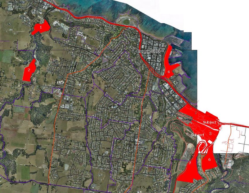
Burnie Paper Mill Site

Document Control
          Job ID:             15580
          Job Name:           Burnie Paper Mill Site Assessment
          Project Director:   Simon Smith
          Project Manager:    Robert Buckmaster
          Company:            Burnie City Council
          Job Contact:        Patrick Earle
          Document Name:      AEC Report Burnie Paper Mill Oct 2010
          Last Saved:         18/10/2010 8:53 AM

          Version             Date                  Reviewed PM   Approved PD
          1.2                 15/10/2010            RB            SS

                                                                                i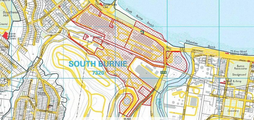
Burnie Paper Mill Site

Executive Summary
Background
          The redevelopment of the former Burnie Paper Mill site                     Land to the north of the railway line towards the highway is
          represents an important strategic opportunity for the future               relatively flat. Land to the south of the site becomes
          economic development of the Burnie region. Well served by                  increasingly steep. Elevated land towards the south east corner
          existing infrastructure, the extensive South Burnie site has               of the site has been identified by Council as an area of active
          historically served as an important economic base for the City,            soil potentially susceptible to slippage.
          although the city‟s economy has diversified in recent years as
                                                                                     Sections of the site have been contaminated by the previous
          the mill progressively wound down its operations. The mill
                                                                                     pulp and paper production processes. Six points of
          closed in mid-2010 and is to undergo site remediation ahead of
                                                                                     environmental interest have been identified by previous site
          disposal by its current owner, Paperlinx. This report considers
                                                                                     investigations.   Owner,     Paperlinx,    advises     that    the
          and assesses alternative uses for the site, recognizing that its
                                                                                     contamination is contained and is working closely with the
          existing industrial zoning may no longer be the most
                                                                                     Environmental Protection Agency to remediate the site to the
          appropriate setting given contemporary requirements and
                                                                                     standard appropriate for an industrial site. Paperlinx anticipates
          expectations.
                                                                                     the remediation process could be potentially completed within
          The subject land is an extensive industrial holding owned by a             12 months.
          Paperlinx subsidiary. Lying south of the Bass Highway between
                                                                                     Part of the site was recently the subject of a development
          Massey Green Drive and Reeve Street, South Burnie, the 37.5
                                                                                     application for a large format/bulky good retail use. The
          hectare site has historically been used as a paper mill and
                                                                                     proposal raised a number of issues of strategic planning
          associated support infrastructure.
                                                                                     significance. Council is satisfied that the proposed use is not
          Direct access to the site is gained via crossovers to Reeves               consistent with the intent of the current zoning and that a
          Street, Old Surrey Road, Massey Green Drive and Marine                     planning scheme amendment would be required to
          Terrace. The central median on Marine Terrace restricts site               accommodate the proposed use.
          access by east-bound traffic.
          The site is extensively developed with older style industrial        Site Context
          buildings in various states of repair developed between the late
          1930s through to the 1950s, associated with the former use.                The South Burnie precinct surrounding the site comprises a mix
          The buildings are aligned to a well developed internal road                of light industrial, peripheral sales and residential development.
          network.                                                                   Industrial and commercial uses follow the low lying land on the
                                                                                     southern side of Bass Highway. Peripheral sales uses include
          The paper mill is considered central to Burnie‟s twentieth                 car yards and electrical supplies. A Harvey Norman based
          century history and development. However, it is understood a               centre is located approximately 650 metres northwest of the
          detailed heritage assessment of the site has not been                      subject land, towards the south end of Burnie CBD.
          undertaken. The Paper Mill is not listed as a building, object or
          site of architectural, historical or scientific interest under the         The subject land fronts Marine Terrace (aka Bass Highway), a
          Burnie Planning Scheme.                                                    four land dual carriageway highway connecting Burnie to

                                                                                                                                                    ii
Burnie Paper Mill Site

          Launceston. Old Surrey Road, on the eastern boundary, is a           Existing administrative buildings located in the north west
          secondary road connecting to Queenstown.                             corner of the site, considered to have some heritage value,
                                                                               could be adaptively re-used for a range of purposes under
          The site is bisected along its east-west axis by TasRail‟s
                                                                               current land use controls including office space, consulting
          Western Line, providing a freight service linking the North West
                                                                               rooms, or educative purposes. The buildings may also have
          region to Launceston and beyond. Prior to the Mill‟s closure,
                                                                               appeal for accommodation, but this use is not presently
          the rail service delivered coal and logs to the Mill site.
                                                                               permitted in the zone and use for this purpose could potentially
          The site is within 1.5 kilometres (by road) of the Port of Burnie,   compromise the wider uses of the site.
          Tasmania‟s largest general cargo port and one of Australia‟s
                                                                               Residential uses are considered inappropriate at the site, given
          largest container ports.
                                                                               the current zoning, and higher site remediation requirements
                                                                               entailed.
Alternative Site Uses
                                                                               Burnie is considered to have an adequate supply of industrial
          The closure of the paper mill operations presents a unique           land given its comparatively modest evident demand. Burnie
          opportunity    to  accommodate       contemporary land       use     has approximately 136.8 hectares of undeveloped industrial
          requirements at this strategic site. A range of alternative land     land of which approximately 73.5 hectares is considered
          uses and site opportunities have been assessed.                      suitable for development. The largest cluster of undeveloped
                                                                               industrial land is at Heybridge, approximately 7 kilometres
          The land is presently zoned industrial. Light and general            south east. Beyond Burnie, there is approximately 223
          industry are permitted uses in the zone and are considered           hectares of industrial zoned land at Burnie-Wynyard Airport
          suitable having regard to the site‟s previous use, existing          and 140 hectares at Devonport Airport.
          infrastructure and improvements, some of which could be
          adaptively re-used as high clearance manufacturing or                In recent years there has been negligible vacant industrial
          warehouse space.                                                     premises available for lease.

          Mineral processing is a discretionary use on the subject site.       Demand for industrial land within the City has been modest. In
          Given limited evidence of market demand for this use at the          the decade to 2009, an average of five vacant industrial lots
          site and potential for adverse amenity impacts on nearby             have been sold per annum within Burnie City. Construction
          residential development the use is considered less than ideal.       activity is consistent with average annual industrial land
                                                                               consumption of approximately 1,900m2. At this rate of
          Excellent highway exposure, direct rail access linking the site to   consumption, current stocks of suitable undeveloped industrial
          the nearby port, Tasmania‟s largest general cargo port,              land is considered sufficient for a number of decades.
          plentiful land and existing onsite infrastructure raise the
          potential of the site as a transport and logistics hub, providing    Approximately 5,800m2 of industrial space was developed in
          an opportunity to consolidate currently dispersed transport          the city over the nine years to 30 June 2009, with the average
          operators at a single site, thereby improving operational            premises encompassing an area of 640m2. Sheds of 400-
          efficiencies.                                                        600m2 are highly sought after, however, demand is acutely
                                                                               price sensitive. Bass Highway frontage is considered an
          Toll Holdings, a major freight operator out of Burnie, notes         advantage and attracts a price premium.
          there is presently a shortage of sites to park semi-trailers at or
          near the port. Toll‟s requirement is for flat, level hardstand       Homemaker retailing refers to larger format retail stores
          area for ease of fork lift operation.                                (usually tenancies of 500m2) or more which typically sell

                                                                                                                                            iii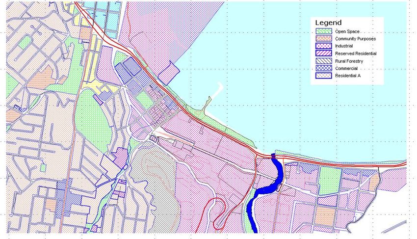
Burnie Paper Mill Site

          merchandise classed as bulky goods or homewares. The size of        and Burnie City Council is recommended to market the site to
          the site required, preferred parking configuration and              potential investors and light industrial, trade and logistics
          development economics typically preclude homemaker retail           firms.
          from locating within conventional shopping centres. Being a
                                                                              It is further recommended that there be investigation into the
          space intensive, discretionary, comparatively low margin and
                                                                              feasibility and business case for developing a freight logistics
          low volume category, turnover per square metre, and hence
                                                                              hub on the site utilising the rail alignment.
          rent levels the use can sustain, are typically lower than
          conventional retailing.                                             It is recommended that Council rezone the north west section
                                                                              of the site to a Regional Home Maker/Service Industry zone or
          Most of Burnie‟s existing bulky goods and large format retailing
                                                                              similar. The purposes of the new zone would include providing
          is spread through the CBD or within South Burnie, typically on
                                                                              for integrated bulky goods showrooms and trade supplies and
          land zoned Commercial or Central Business. A number of
                                                                              to protect and enhance the role of Burnie as the retail and
          national homemaker retailers are not presently represented in
                                                                              services regional centre for north-western Tasmania and to
          Northern or North Western Tasmania.
                                                                              accommodate retail goods and services not available in other
          A number of alternative commercial and industrial zoned sites       centres.
          around the municipality of comparable size to the parcel sought
                                                                              The current industrial zoning would be retained on the
          by Bunnings have been assessed and found less suitable in
                                                                              remainder of the site.
          terms of exposure, traffic capacity, proximity to existing retail
          and commercial precincts, topography and/or market-
          readiness.
          Burnie is considered to have an adequate supply of industrial
          land given the comparatively modest demand evident in recent
          years. The city has approximately 136.8 hectares of
          undeveloped industrial land of which approximately 73.5
          hectares is considered suitable for development. New industrial
          construction within the City since 2004 is consistent with a
          vacant land consumption rate of 1,925m2 per annum. Plentiful
          industrial land is available in the wider region, including large
          holdings at the Burnie-Wynyard and Devonport airports.
          In order to prevent the potential of the Paper Mill site being
          compromised by its hasty sale to an unsympathetic purchaser,
          it is recommended that the Tasmanian Government and/or
          Burnie City Council seriously consider acquiring that part of the
          site not sought by Bunnings as a strategic land bank. Any such
          purchase should be subject to the land being remediated by
          the vendor to an appropriate standard as determined by the
          Environment Protection Authority.
          A proactive investment attraction program by the Tasmanian
          Department of Economic Development, Cradle Coast Authority

                                                                                                                                           iv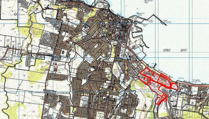
Burnie Paper Mill Site

             Figure 1.1: Aerial view of Subject Site

                                                       v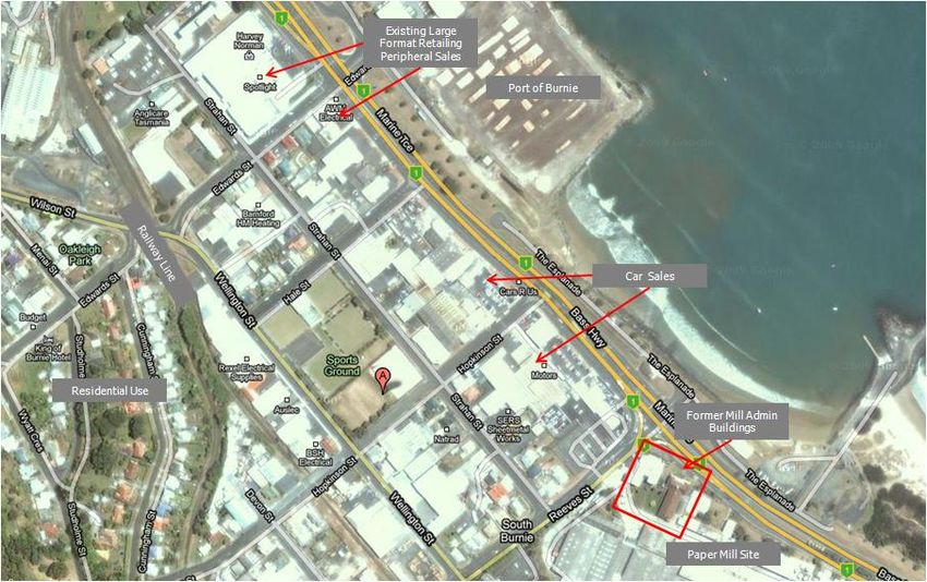
Burnie Paper Mill Site

Table of Contents
          DOCUMENT CONTROL......................................................................................................................................................................I
          EXECUTIVE SUMMARY ................................................................................................................................................................... II
          TABLE OF CONTENTS.......................................................................................................................................................................I
          TABLE OF FIGURES ...................................................................................................................................................................... IV
          1.     INTRODUCTION ..................................................................................................................................................................... 1
          1.1     BACKGROUND ............................................................................................................................................................................. 1
          1.2     METHODOLOGY ........................................................................................................................................................................... 1
          1.3     ACKNOWLEDGEMENTS .................................................................................................................................................................... 3
          2.     CONTEXT REVIEW .................................................................................................................................................................. 4
          2.1     LOCATION ................................................................................................................................................................................. 4
                  2.1.1 REGIONAL CONTEXT............................................................................................................................................................ 4
          2.2     SITE ANALYSIS ........................................................................................................................................................................... 6
                  2.2.1 BUILT FORM ..................................................................................................................................................................... 6
                  2.2.2 HERITAGE CONSIDERATIONS .................................................................................................................................................. 8
                  2.2.3 TOPOGRAPHY .................................................................................................................................................................... 8
                  2.2.4 SOIL STABILITY ................................................................................................................................................................. 8
                  2.2.5 SITE CONTAMINATION ........................................................................................................................................................10
          2.3     IMMEDIATE NEIGHBOURHOOD ..........................................................................................................................................................11
          2.4     TRANSPORT AND LINKAGES .............................................................................................................................................................15
                  2.4.1 ROAD ...........................................................................................................................................................................15
                  2.4.2 RAIL ............................................................................................................................................................................15
                  2.4.3 PORT ............................................................................................................................................................................16
                  2.4.4 AIR PORT .......................................................................................................................................................................17
          2.5     ASSESSMENT OF ALTERNATIVE SITE USES ...........................................................................................................................................18

                                                                                                                                                                                                             i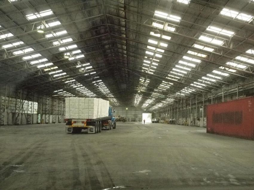
Burnie Paper Mill Site

          2.6     SITE OPPORTUNITIES ...................................................................................................................................................................23
                  2.6.1 HIGH CLEARANCE SPACE .....................................................................................................................................................23
                  2.6.2 FREIGHT & LOGISTICS ........................................................................................................................................................23
                  2.6.3 BULKY GOODS & TRADES SUPPLIES ........................................................................................................................................23
          3.     ASSESSMENT OF ALTERNATIVE SITE USES .......................................................................................................................... 24
          3.1     INDUSTRIAL USES .......................................................................................................................................................................24
                  3.1.1 SUPPLY OF INDUSTRIAL LAND ................................................................................................................................................24
                  3.1.2 DEMAND FOR INDUSTRIAL LAND .............................................................................................................................................24
                  3.1.3 KEY INDUSTRIAL LOCATIONS .................................................................................................................................................25
                  3.1.4 POTENTIAL INDUSTRIAL LAND SUPPLY ......................................................................................................................................26
                  3.1.5 INDUSTRIAL SITE SALES ......................................................................................................................................................26
                  3.1.6 INDUSTRIAL CONSTRUCTION ACTIVITY ......................................................................................................................................27
                  3.1.7 SALES OF IMPROVED INDUSTRIAL PROPERTY ...............................................................................................................................28
                  3.1.8 INDUSTRIAL LEASING ACTIVITY ..............................................................................................................................................29
          3.2     FREIGHT & LOGISTICS ..................................................................................................................................................................32
                  3.2.1 TOLL HOLDINGS ...............................................................................................................................................................33
                  3.2.2 TASPORTS ......................................................................................................................................................................33
          3.3     LARGE FORMAT RETAIL & TRADE SUPPLIES ..........................................................................................................................................34
                  3.3.1 HOMEMAKER RETAIL DEFINED ...............................................................................................................................................34
                  3.3.2 EXISTING HOMEMAKER RETAIL ..............................................................................................................................................34
                  3.3.3 HOMEMAKER GAP ANALYSIS .................................................................................................................................................35
                  3.3.4 ALTERNATIVE HOMEMAKER & BULKY GOODS SITES. ......................................................................................................................37
          4.     ENVIRONMENTAL & INFRASTRUCTURE CONSIDERATIONS .................................................................................................. 39
          4.1     INFRASTRUCTURE ........................................................................................................................................................................39
                  4.1.1 SEWERAGE .....................................................................................................................................................................39
                  4.1.2 STORM WATER DRAINAGE ....................................................................................................................................................39
                  4.1.3 ELECTRICITY ...................................................................................................................................................................39

                                                                                                                                                                                                         ii
Burnie Paper Mill Site

                   4.1.4 GAS .............................................................................................................................................................................39
                   4.1.5 TELECOMMUNICATIONS .......................................................................................................................................................39
          5.     PLANNING ASSESSMENT ...................................................................................................................................................... 40
          5.1     STATE PLANNING POLICY FRAMEWORK ................................................................................................................................................40
                   5.1.1 PLANNING SCHEME AMENDMENTS WHERE THE LAND MAY BE CONTAMINATED .........................................................................................40
          5.2     LOCAL PLANNING POLICY FRAMEWORK ................................................................................................................................................43
          5.3     LOCAL STRATEGIC DOCUMENTS ........................................................................................................................................................44
                   5.3.1 BURNIE STRATEGIC PLAN.....................................................................................................................................................44
                   5.3.2 SETTLEMENT & INVESTMENT STRATEGY FOR BURNIE TO 2026 ..........................................................................................................44
                   5.3.3 BURNIE PLANNING SCHEME 1989 ..........................................................................................................................................45
          5.4     PLANNING PRECEDENTS FOR LARGE FORMAT HOMEMAKER RETAILING ELSEWHERE ..............................................................................................48
                   5.4.1 BUNNINGS KINGS MEADOWS ................................................................................................................................................48
                   5.4.2 BUNNINGS MOONAH ..........................................................................................................................................................49
                   5.4.3 BUNNINGS ROSNY PARK ......................................................................................................................................................49
                   5.4.4 CAMBRIDGE PARK HOMEMAKER CENTRE ....................................................................................................................................49
                   5.4.5 DEVONPORT ....................................................................................................................................................................49
                   5.4.6 LAUNCESTON ...................................................................................................................................................................50
          5.5     NEW PLANNING SCHEMES ..............................................................................................................................................................50
          6.     PROPOSED PLANNING SCHEME AMENDMENT ....................................................................................................................... 51
          6.1     SOIL CONTAMINATION ..................................................................................................................................................................51
          6.2     REGIONAL HOMEMAKER ZONE OR SIMILAR ...........................................................................................................................................51
          7.     CONCLUSIONS & RECOMMENDATIONS................................................................................................................................. 53
          REFERENCES ................................................................................................................................................................................ 55
          APPENDIX A: TABLE OF USES – INDUSTRIAL ZONE ..................................................................................................................... 56

                                                                                                                                                                                                          iii
Burnie Paper Mill Site

Table of Figures
Figure 1.1: Aerial view of Subject Site ................................................................................................................................................................ v
Figure 1.1: Looking northwards across Burnie Paper Mill towards Emu Bay. ............................................................................................................ 1
Figure 1.2: Looking northwards across Burnie Paper Mill towards Emu Bay. ............................................................................................................ 1
Figure 2.1.1: Burnie Port from Upper Burnie ........................................................................................................................................................ 4
Figure 2.2: Site Context Map ............................................................................................................................................................................. 5
Figure 2.3: Old Engine Building to rear of site. ..................................................................................................................................................... 6
Figure 2.4: Internal view of site. ........................................................................................................................................................................ 6
Figure 2.5: Site Plan......................................................................................................................................................................................... 7
Figure 2.6: Georgian Revival architecture............................................................................................................................................................ 8
Figure 2.7: Art Deco Administrative Building on the North West corner of the site. ................................................................................................... 8
Figure 2.8: Soil Stability Map ............................................................................................................................................................................. 9
Figure 2.9: Existing Site improvements – older style asbestos cladding. ............................................................................................................... 10
Figure 2.10: Existing Site improvements towards south of site, beyond railway alignment. ..................................................................................... 10
Figure 2.11: Harvey Norman Centre on Marine Tce, South Burnie ........................................................................................................................ 11
Figure 2.12: Holden Car Yard on Marine Tce, South Burnie .................................................................................................................................. 11
Figure 2.13: Immediate Neighbourhood ............................................................................................................................................................ 12
Figure 2.14: Land Use Zoning Controls around the Subject Site ........................................................................................................................... 13
Figure 2.15: Aerial View of South Burnie showing existing pattern of land use. ...................................................................................................... 14
Figure 2.16: Marine Tce (Bass Hwy) – Four lane dual carriage way arterial............................................................................................................ 15
Figure 2.17: Emu Bay Railway (Melba Line) ....................................................................................................................................................... 15
Figure 2.18: Port of Burnie .............................................................................................................................................................................. 16
Figure 2.19: Port of Burnie with Cruise ship berthed ........................................................................................................................................... 17
Figure 2.20: Existing High clearance space on site ideal for storage. .................................................................................................................... 23
Figure 2.21: Interior view of former Mill ............................................................................................................................................................ 23

                                                                                                                                                                                                            iv
Burnie Paper Mill Site
Figure 3.1: Value of Industrial Building Approvals, City of Burnie ($,000 Constant June 2009) ................................................................................. 27
Figure 3.2: Port of Burnie ................................................................................................................................................................................ 32
Figure 3.3: Harvey Norman Centre, Marine Tce, South Burnie ............................................................................................................................. 34
Figure 3.4: Retravision, Alexander St, Burnie .................................................................................................................................................... 34
Figure 3.5: Location of other Commercial or Industrial sites of 5 hectares or larger ................................................................................................ 38
Figure 5.1: Planning Framework Map. ............................................................................................................................................................... 42
vBurnie Paper Mill Site
1. Introduction
1.1 Background Figure 1.1: Looking northwards across Burnie Paper
Mill towards Emu Bay.
The redevelopment of the former Burnie Paper Mill site represents an important
strategic opportunity for the future economic development of the Burnie region. Until
the mill‟s closure in mid-2010, the expansive industrial site situated on the south side
of the Bass Highway between Massey Green Drive and Reeve Street, South Burnie,
accommodated the paper making operations of Paperlinx subsidiary, Tasmania Paper
Pty Ltd and its associated support infrastructure. This operation for many years
served as the economic base for the City, although the city‟s economy has diversified
in recent decades as the mill progressively wound down its operations. Figure 1.2: Looking northwards across Burnie Paper
Mill towards Emu Bay.
In the last few years sections of the land have been sold and are now occupied by
other industrial activities. Tasmania Paper is now seeking to divest itself of the
remaining land, subject to first remediating it of contamination to the satisfaction of
the Environment Protection Authority.
Interest in part of the site has been expressed by a national retail chain proposing to
develop a large format retail building supply and hardware outlet. The proposal
involves a manner of development was not contemplated by the Burnie Planning
Scheme in a location removed from Burnie‟s primary retail centre and thus raises
issues of strategic planning importance which need be resolved before the immediate
considerations of site capability and the nature of regulatory provisions can be
addressed. Core considerations are industrial and commercial strategies for Burnie
and its region of influence; and with the future of the site.
1.2 Methodology
As agreed by the project steering committee at the project inception meeting,
conducted on 30 June 2010, the study was conducted in accordance with the
methodology outlined in AECgroup’s proposal dated 19 May 2010.
The study was informed by a range of policy and strategic documents including:
Burnie Planning Scheme
Burnie Settlement and Investment Strategy
Cradle Coast Planning Initiative Draft Report
Planning schemes and Industrial land strategies of neighbouring municipalities
(Waratah-Wynyard, Central Coast).
Burnie Heritage Study;
1Burnie Paper Mill Site
AECgroup’s Burnie Industrial Land Study (2009)
Council and Dept of Economic Development‟s previous industrial land assessments;
Best practice examples of industrial and bulky goods/large format retail land use controls and strategies;
An extensive range of stakeholders were interviewed to gain a more detailed appreciation of:
Current land usage patterns, aspirations and issues
Adequacy of infrastructure at the site and likely future requirements under alternative scenarios;
Near and intermediate-term plans for existing site uses and operations;
Preferred land use options for the future use of the Paper Mill site;
Site access and management of traffic movement;
Burnie‟s transport and logistics requirements including needs of the Port of Burnie;
Appropriate inclusions;
Land Use issues of regional significance;
Issues or concerns with current industrial land use controls;
Future vision for the site;
Major property requirements.
Key stakeholders consulted in the course of the project included:
Burnie Council planning officers
Paperlinx (the proprietors of the Paper Mill site);
Australian Paper (former site operator)
Hazell Bros (adjoining owners);
Commercial Estate agents and valuers including PRD Nationwide, Esk Property Group and City and Rural Real Estate;
Burnie Chamber of Commerce
Property developers
TasPorts (Port of Burnie)
TasRail (operates rail line through the site);
Transport and Logistics operators, including Toll Holdings, De Bruyn‟s Transport and Chas Kelly Transport;
Department of Economic Development, Tourism and the Arts (industrial development and traffic management);
AusIndustry/Enterprise Connect
EPA.
2Burnie Paper Mill Site
1.3 Acknowledgements
The project was guided and advised by a Steering Committee, which provided local knowledge, consultation leads, views on strategy and
technical matters and review of the strategy process. Membership of the Steering Committee include:
Attendee Organisation Role
Patrick Earle Burnie City Council Director, Land and Environmental Services
Paul Arnold Burnie City Council General Manager
Rodney Greene Burnie City Council Director, Community and Economic Development
John Macleod Department of Economic Project Officer, Property & Land Use Development
Development, Tourism & Arts
3Burnie Paper Mill Site
2. Context Review
2.1 Location Figure 2.1: Aerial View of Burnie
The Paper Mill site is located at 72 Marine Terrace, South Burnie, approximately 1.6
kilometres south east of Burnie CBD.
Burnie is an urban centre and sea port situated on Emu Bay at the mouth of the Emu
River. It lies on the Bass Highway to Launceston 148 kilometres east at the junction of
the main western and west coast rail lines. Somerset adjoins Burnie to the west.
2.1.1 Regional Context
Tasmania‟s fourth largest urban centre (2006 population 19,160 (Australian Bureau of
Statistics)), Burnie is a key commercial centre for the Mersey-Lyell region of the state‟s
North West. The region is rich in natural resources such as fisheries, timber,
groundwater, extractive resources and productive soils and these resources are an
important part of the regional economy.
Figure 2.1.1: Burnie Port from Upper Burnie
Three quarters of this region‟s population occupies a narrow coastal urban strip
extending from Smithton in the west to Port Sorrell in the east.
Burnie and Devonport, separated by a distance of approximately 50 kilometres, are the
two major population centres for the region and both have competed over time to
develop as the leading regional centre, with resultant duplication of services. Both cities
have air and sea ports, connected by rail to other major Tasmanian towns. Burnie is the
region‟s leading retail node, reflected by its retail mix, major anchor tenants,
development activity, trade area penetration and market share (AECgroup, 2007). The
retail sector has traditionally been almost entirely contained within the central business
district (CBD), including large format retail uses. Burnie is base for the Cradle Coast
campus of the University of Tasmania, the North West Institute of TAFE and is home to
the North West Regional Hospital, a modern 160 bed facility.
4Burnie Paper Mill Site
Figure 2.2: Site Context Map
Source: (Land Information System Tasmania (The LIST), 2010)
5Burnie Paper Mill Site
2.2 Site Analysis
The former Burnie Paper Mill site comprises approximately 37.5 hectares located at Figure 2.3: Old Engine Building to rear of site.
72 Marine Terrace, South Burnie. The subject land is irregular in shape and made up
of nine separate lots with frontages to Marine Terrace (aka Bass Highway) to the
north, Old Surrey Road to the east, Massey Greene Drive to the south east, and
Reeves Street to the west.
Direct access to the site is via crossovers to Reeves Street, Old Surrey Road, Massey
Green Drive and Marine Terrace. Marine Terrace is divided by a median strip, which
presently limits direct access to the site by vehicles travelling in an easterly direction.
East-bound traffic can currently gain site access via Reeves Street Massey Greene
Drive.
The site is divided along its east-west axis by TasRail‟s Western line.
The site‟s internal road network includes a crossing of the railway line towards Old
Surrey Road frontage.
2.2.1 Built Form
The site is extensively developed with older style industrial buildings developed Figure 2.4: Internal view of site.
between the late 1930s through to the 1950s associated with the former pulp and
paper manufacturing process, ancillary plant and office buildings. Existing buildings
cover approximately 22% of the site area, and range from one to three or more
storeys. A diverse range of building materials have been used including brick,
corrugated iron and asbestos (used for alternatively for cladding and roofs).
Two older style brick office buildings, respectively two and three storeys are located
at the north west corner of the site facing Marine Terrace.
The paper mill buildings are aligned to a well developed internal road network, which
includes a rail crossing connecting the southern portion of the site.
6Burnie Paper Mill Site
Figure 2.5: Site Plan
7Burnie Paper Mill Site
2.2.2 Heritage Considerations
The Paper Mill is central to the story of Burnie‟s twentieth century history and
Figure 2.6: Georgian Revival architecture
development (GHD). The Burnie Mill was the first commercial scale producer of paper
manufactured from 100% eucalyptus pulp in Australia.
Construction of the Mill commenced in 1937. On completion, the main structure was
964 feet in length and varied between 150 to 220 feet in width, averaging 50 feet in
height. Operations began on 27 August 1938. The site employed nearly 500 staff and
a further 200 people in the bush supplied the logs for processing.
The Paper Mill ceased paper making operations on 16 June 2010 (Dunham, 2010).
GHD notes the Mill‟s historical significance as the first commercial scale producer of
paper manufactured from 100% eucalyptus pulp in Australia. As the largest
development and employer in Burnie, the Mill was fundamental to the transformation
of the town into a major industrial and population centre. It is understood that a
detailed heritage assessment of the site has not been undertaken.
The Paper Mill is not listed as a building, object or site of architectural, historical or
scientific interest under the Burnie Planning Scheme. Nevertheless, two of the former
administrative buildings (depicted to the right), appear to have aesthetic and
architectural interest, as well as potential for adaptive re-use for other purposes. Figure 2.7: Art Deco Administrative Building on the
North West corner of the site.
2.2.3 Topography
Land to the north of the railway line towards the highway is relatively flat. To the
south the rail the site becomes increasingly steep, with an average gradient of one in
twelve.
2.2.4 Soil Stability
This report has relied upon soil stability information made available by Burnie City
Council. We are advised that land to the west of the site near Emu River comprises
river sediment and Testing of sub-surface conditions was outside the scope of this
brief and remain unknown, warranting further investigations by appropriately
qualified geo-technicians.
Elevated land around the water tank towards the south east corner of the subject
land and along the south western boundary of the property has been identified by
Council as an area of active soil potentially susceptible to slippage in the event of
disturbance, clearance or a major rain event (refer figure 2.8).
8Burnie Paper Mill Site
Figure 2.8: Soil Stability Map
9Burnie Paper Mill Site
2.2.5 Site Contamination
Sections of the site have been contaminated by the previous pulp and paper production Figure 2.9: Existing Site improvements – older
processes. Some investigations were made to quantify the extent of site contamination style asbestos cladding.
and extent of remediation required during the 1990s and early 2000s. Six points of
environmental interest have been identified within the site (Warren Jones, 2010). It is
understood that the cell house has a high degree of mercury contamination and mercury
contamination has been detected in a water bore to the north east of the site. Site
redevelopment could potentially disturb contaminated soils impacting on water quality
through the transport of sediments into surface water. Tasmanian policy on water quality
management requires that a permit for use or development of land be accompanied by
sufficient information to demonstrate capability of the land to support redevelopment and
adequate environmental risk mitigation measures are in place.
Owner, Paperlinx advises that the contamination is contained and is working closely with
the Environmental Protection Agency through an Environmental Effects Reporting process
to remediate the site to the standard appropriate for an industrial site.
Paperlinx anticipates the remediation process could be completed within approximately 12
months, although has made no firm commitment as to the staging of the decontamination.
Paperlinx anticipates the remediation process could be completed within
approximately 12 months, although has made no firm commitment as to
the staging of the decontamination.
Figure 2.10: Existing Site improvements towards
south of site, beyond railway alignment.
10Burnie Paper Mill Site
2.3 Immediate Neighbourhood
The South Burnie precinct surrounding the subject land comprises a mix of light Figure 2.11: Harvey Norman Centre on Marine Tce,
industrial, peripheral sales, and residential development. Peripheral sales uses, including South Burnie
car yards front Marine Terrace and port uses line the deep water harbour of Emu Bay.
The industrial and commercial uses hug the low lying land on southern side of Bass
Highway south of Burnie CBD, flanking Emu River continuing east to Round Head and
extending between two and six blocks inland. Industrial uses are flanked to the west and
south west by low rise residential development and a rural forestry zone, located
immediately south of the Mill site.
Peripheral sales uses lining Marine Terrace westward from the subject land include a
couple of car sales yards (Nissan, Cars R Us) and AWM electrical supplies. A big box
centre anchored by Harvey Norman and comprising a Spotlight store is located on the
North West corner of Marine Terrace and Edwards Street, approximately 650 metres
North West of the subject land.
The surrounding side streets are lined with one and the occasional two level trade-
related businesses (electrical, plumbing, timber and auto parts)
The Port of Burnie is located on the western edge of Burnie CBD, approximately 1.5
kilometres North West of the subject land by road. Figure 2.12: Holden Car Yard on Marine Tce, South
Burnie
11Burnie Paper Mill Site
Figure 2.13: Immediate Neighbourhood
Source: The LIST
12Burnie Paper Mill Site
Figure 2.14: Land Use Zoning Controls around the Subject Site
Source: Burnie City Council
Notes: Listed Uses as per Burnie Planning Scheme.
The Community Purposes Zone is primarily intended to identify land for the present or future public or institutional use; ensure that development is in the public interest and takes account of the needs of future
populations; ensure that large scale public and institutional use of land is appropriately located and related to the surrounding land uses; and ensure that locations are available for specific public uses such as
disposal areas, cemeteries, crematoria, schools and Council depots.
13Burnie Paper Mill Site
Figure 2.15: Aerial View of South Burnie showing existing pattern of land use.
14Burnie Paper Mill Site
2.4 Transport and Linkages
Burnie is developing as a transport hub for the North West coast of Tasmania, served Figure 2.16: Marine Tce (Bass Hwy) – Four lane dual
by a port, major roads, rail and airport. The existing transport network has been carriage way arterial
adequate in handling the region‟s demand for the past 20 years and is considered a
regional competitive advantage, providing a key driver for the location of major
industry in the region (AECgroup, 2007). The region is approximately 3.5 hours‟ drive
north of Hobart and a one hour flight across Bass Strait from Melbourne.
2.4.1 Road
The Mill fronts Marine Terrace (aka Bass Highway), a four lane dual carriageway
highway connecting Burnie to Launceston 148 km east and to the North West coast to
the west. Bass Highway is part of the AusLink National Highway Network.
Old Surrey Road, forming the eastern boundary of the property, is a secondary road
which connects through to Queenstown (via Ridgeley), Zeehan and beyond to Hobart.
Reeves Street, forming the western boundary is a local secondary road providing
access to South Burnie and the Brooklyn residential to the south.
2.4.2 Rail
Figure 2.17: Emu Bay Railway (Melba Line)
The site is bisected along its east-west axis by TasRail‟s Western line, providing a
freight service linking Wiltshire in the state‟s north west through to Launceston and
beyond to Hobart. The Melba/Emu Bay line, serving Rosebery and Mount Lyell Mining
(near Zeehan) follows the southern boundary. South Burnie Station, on the
Melba/Emu Bay Line, is located to the immediate south of the subject land. Both lines
connect to the Port of Burnie.
The freight-only TasRail network transports approximately 2 million tonnes of freight
per annum around Tasmania, accounting for approximately 20% of the land-based
freight transport haul. Major haulage includes cement, wood chips, logs, containers,
coal, sulphuric acid, minerals and fertiliser.
Recent rail network upgrades have increased speed to 80 kilometres/hour.
Prior to the Mill‟s closure, the rail service to the site was used to deliver coal and logs.
TasRail advises that there are approximately four train movements through the site
per day: one east-bound and one west-bound each morning and each afternoon.
15Burnie Paper Mill Site
TasRail proposes to rationalise the current rail yard at the site by removing Figure 2.18: Port of Burnie
some points and tracks to facilitate on- train shunting and passing on the
site rather than at the Burnie waterfront where it currently occurs, posing a
safety hazard to pedestrians accessing the waterfront.
2.4.3 Port
The subject property is located within 1.5 kilometres (by road) of the Port
of Burnie, Tasmania‟s largest general cargo port and one of Australia‟s
largest container ports. In 2008-09 the port accounted for 28% of the total
Tasmanian freight task, well ahead of Devonport (21.5%) and second only
to Bell Bay (31.7%) (TasPorts, 2009).
Port facilities were enlarged in the 1960s after the completion of the West
Coast Outlet Road. Operated by TasPorts, the port services Tasmania‟s
major west coast mines and handles most types of bulk shipping,
containerised cargo, copper, lead, zinc, and tin concentrates and the
cereals, potatoes, and livestock produced in the area. Trade is facilitated
through two container cranes and two berths with stern loading ramps. The
port is able to accommodate large quarter ramp vessels at three berths and
Toll Shipping (the major operator) has roll-on, roll-off facilities (Cradle
Coast Authority, DIER, 2006). The port has a large cold store and excellent
intermodal access to road and rail infrastructure.
The majority of Tasmania‟s non-bulk trade is with the Australian mainland.
Toll operates two purpose-built container cargo vessels of approximately
520 TEU capacity between Port Melbourne and Burnie seven days a week
each in alternate directions (TasPorts, 2009). ANL operates a lift on/lift off
container services operation once per week to Burnie. During 2008/09 the
port attracted 503 ship visits, with 4.166 million mass tonnes total trade
and 213,195 TEUs (TasPorts, 2009).
While sea passenger and car services to and from the mainland are
provided at Devonport, Burnie is rapidly becoming a preferred destination
for cruise ships, by virtue of its deep water port. As Tasmania terminal for
the Spirit of Tasmania car ferry service, Devonport has historically
attracted more visitor numbers than Burnie, although the differential
between the two has diminished over time. The Port of Burnie has a more
efficient intermodal arrangement that the Port of Devonport, with direct rail
Source: TasPorts
access for container traffic. Rail access at the Port of Devonport is located
on the opposite (western) side of the port to the container node, posing
inter-modal inefficiencies.
16Burnie Paper Mill Site
TasPorts intends that Burnie port will be further developed as Tasmania‟s premier bulk Figure 2.19: Port of Burnie with Cruise ship
commodity port, and retain a “roll on roll off” general coastal cargo capability. To this berthed
end, it is working closely with Toll, the Burnie City Council, Pacific National Tasmania and
key business groups on proposals to expand the Burnie port‟s container freight capacity
(TasPorts, 2009). However, TasPort‟s preference, as articulated in its Strategic Plan
(formulated before the Mill site became available), is to accommodate northern
Tasmania‟s anticipated freight growth at a new Integrated Gateway to be developed at
Bell Bay Port, on the Tamar south of George Town.
2.4.4 Air Port
Burnie Airport, owned and operated by Burnie Council, is situated 19.3 kilometres north
west of the town, in Wynyard. It is serviced by Regional Express, providing daily direct
flights to and from Melbourne. Around 2,000 passengers pass through the airport weekly
(AECgroup, 2007). The discontinuance of the QantasLink service to the airport several
years ago has reduced competition and the number of routes serviced by the airport.
Discount airlines Virgin Blue and Jetstar operate services to and from Launceston Airport,
which consequently has increased its share of the northern Tasmanian air passenger
market at the expense of Burnie and Devonport.
17Burnie Paper Mill Site
2.5 Assessment of Alternative Site Uses
The following table sets out a range of alternative land uses which could potentially be accommodated on the Paper Mill site and key
considerations supporting or countering these alternatives. Selective land uses considered as presenting realistic opportunities for the site are
further discussed in the following section.
Table 2.1: Alternative Land Uses for the Subject Site
Potential Land Use Positives Negatives Conclusions
Commercial Excellent exposure & passing trade. Prohibited use under current zone. Raised as a potential use of the existing
accommodation (Hotel, A potential adaptive re-use of existing Potentially incompatible with industrial uses of administrative buildings to the NW of the site,
Motel, Bed & Breakfast) administrative buildings to the NW of the site. remainder of the site. but would require an amendment to current
planning controls.
May be incompatible with or prejudice of
balance of the site for industrial purposes.
Container/Bulk Site within 1.5 kilometres of Port of Burnie, Existing connection to the port is by highway. Warrants further investigation as a potentially
Commodity Storage which TasPorts intends to develop as Operational inefficiencies arising from the need more economical alternative to land
Tasmania’s premier bulk commodity port. to transport containers between the site and reclamation at the port.
Limited site capacity at the Port. the port by registered vehicles.
Potential interest in site from Toll. Construction of a grade separated off-road
Strong growth in container and general freight connection to enable the use of forklifts is
volume is forecast. potentially costly.
Consulting Excellent exposure and good access. Somewhat removed from Burnie CBD and A potential adaptive re-use of the existing
Rooms/Health Centre Potential utilises existing site improvements on existing hospital. administrative buildings to the NW of the site
the north west corner of the site which would which could be accommodated under current
likely need to be retained due to aesthetic and planning controls.
heritage value.
A discretionary use within the current zone.
Conventional Retail Excellent highway exposure. Shops (other than neighbourhood shops) are a Such development would be inconsistent with
Reasonable site access and egress prohibited use under current (Industrial) the Burnie Planning Scheme, which places a
Large site affording ample scope for adequate zoning. retaining retail within the CBD.
parking. Would potential undermine the strength of
Burnie CBD.
Inconsistent with the Burnie Settlement and
Investment Strategy which favours the
concentrating retail activity in the CBD.
Educational A discretionary use within the current zone. Existing campuses appear adequately served. A potential adaptive re-use of the existing
Establishment A potential adaptive re-use of existing administrative buildings to the NW of the site.
administrative buildings to NW of site. A recommended permissible use within a
Site is located near existing Australian proposed Light Industry zone.
Technical College, situated in Wellington St,
South Burnie.
18You can also read