HESLINGTON PARISH NEIGHBOURHOOD PLAN - Pre-Submission Draft for Consultation (Regulation 14)
←
→
Page content transcription
If your browser does not render page correctly, please read the page content below
HESLINGTON PARISH NEIGHBOURHOOD PLAN

 HESLINGTON PARISH
NEIGHBOURHOOD PLAN

 Pre-Submission Draft
   for Consultation
    (Regulation 14)
        January 2019
HESLINGTON PARISH NEIGHBOURHOOD PLAN

                                                INDEX

1     INTRODUCTION                                            1

2     PREPARATION OF THE NEIGHBOURHOOD PLAN                   2

3     WHAT THE PLAN AIMS TO ACHIEVE                           4

4     HESLINGTON - EVIDENCE AND DATA                          6

5     STRATEGIC CONTEXT                                       6

5.1   PLANNING CONTEXT                                        6
5.2   HESLINGTON VILLAGE LOCATION WITHIN THE CITY OF YORK.    9
5.3   LANDSCAPE SETTING                                       9
5.4   HISTORY AND CHARACTER                                   9
5.5   PLAN DEVELOPMENT                                       10
5.6   THE UNIVERSITY OF YORK                                 10
5.7   YORK SCIENCE PARK                                      10
5.8   WIDER SOCIO-ECONOMIC AND ENVIRONMENTAL CONTEXT         10
5.9   SOCIO-ECONOMIC CHARACTERISTICS                         11

6     COMMUNITY AND STAKEHOLDER ENGAGEMENT                   14

6.1   QUESTIONNAIRES                                         14
6.2   RESIDENTS                                              14
6.3   BUSINESSES AND LANDOWNERS                              14
6.4   LIAISON WITH UNIVERSITY OF YORK                        15
6.5   UNIVERSITY UNDERGRADUATES, POSTGRADUATES AND STAFF     15
6.6   CONSULTATION RESPONSES TO QUESTIONNAIRES               15

7     GROWTH STRATEGY                                        15

7.1 OVERVIEW                                                 15
7.2 DELIVERING GROWTH                                        16

8     BUSINESS, EMPLOYMENT AND LOCAL FACILITIES              16

8.1   PURPOSE                                                16
8.2   RATIONALE AND EVIDENCE                                 16
8.3   MAIN STREET                                            18
8.4   YORK SCIENCE PARK                                      19
8.5   TRAVEL AND TRAFFIC IMPLICATIONS                        19
8.6   USE OF LOCAL FACILITIES                                19
8.7   BUSINESS, EMPLOYMENT AND LOCAL FACILITIES POLICIES     20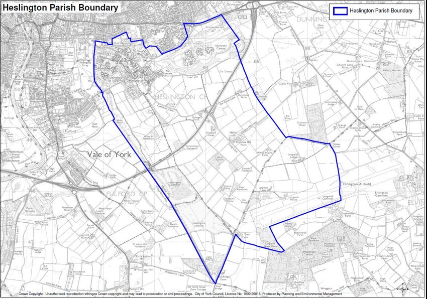
HESLINGTON PARISH NEIGHBOURHOOD PLAN

POLICY HES: 1 MAIN STREET - CHANGE OF USE                  20
POLICY HES: 2 NEW BUSINESS AND EMPLOYMENT DEVELOPMENT      21

9   AGRICULTURE AND RURAL ENTERPRISE                       22

9.1 PURPOSE                                                22
9.2 RATIONALE AND EVIDENCE                                 22
9.3 AGRICULTURE AND RURAL ENTERPRISE POLICY                24
POLICY HES: 3 AGRICULTURE AND RURAL ENTERPRISE             24

10 URBAN DESIGN AND CHARACTER                              25

10.1 PURPOSE                                               25
10.2 RATIONALE AND EVIDENCE                                25
10.3 CHARACTER APPRAISALS                                  26
10.4 URBAN DESIGN ANALYSIS                                 27
10.5 CONSULTATION RESPONSES                                27
10.6 HERITAGE ASSETS                                       28
10.7 PERMEABILITY WITHIN THE VILLAGE                       29
10.8 QUALITY OF THE BUILT ENVIRONMENT                      29
10.9 URBAN DESIGN AND CHARACTER POLICIES                   30
POLICY HES: 4 SUSTAINABLE DESIGN                           30
POLICY HES: 5 URBAN CHARACTER                              32
POLICY HES: 6 CONVERSION OF EXISTING BUILDINGS             32

11 HOUSING                                                 33

11.1 PURPOSE                                               33
11.2 RATIONALE AND EVIDENCE                                33
11.3 HOUSING DEVELOPMENT IN HESLINGTON VILLAGE             34
11.4 HOUSING POLICIES                                      35
POLICY HES: 7 NEW HOUSING                                  35
POLICY HES: 8 HOUSING MIX AND AFFORDABILITY                35
POLICY HES: 9 HOUSING AND COMMUNITY FACILITIES             36
POLICY HES: 10 STUDENT ACCOMMODATION                       37

12 DESIGNATIONS: LOCAL GREEN SPACES                        38

12.1 PURPOSE                                               38
12.2 RATIONALE AND EVIDENCE                                38
12.3 SITES TO BE DESIGNATED                                38
12.4 LOCAL GREEN SPACE POLICY                              41
POLICY HES: 11 LOCAL GREEN SPACE                           41

13 GREEN INFRASTRUCTURE                                    43

13.1 PURPOSE                                               43
13.2 RATIONALE AND EVIDENCE                                43
HESLINGTON PARISH NEIGHBOURHOOD PLAN

13.3 GREEN INFRASTRUCTURE IN THE YORK DRAFT LOCAL PLAN                                44
13.4 GREEN WEDGES AND CORRIDORS                                                       44
13.5 SITES IN ALPHABETICAL ORDER                                                      44
13.6 OS10 PROPOSED NEW OPEN SPACE (645 485)                                           47
13.7 LOWER DERWENT VALLEY NATIONAL NATURE RESERVE                                     47
13.8 FOOTPATHS, BRIDLEWAYS AND CYCLE ROUTES                                           48
13.9 WOODS AND HEDGES, DITCHES AND GRASS FIELD MARGINS                                48
13.10 EVIDENCE OF THE IMPORTANCE PLACED ON GREEN INFRASTRUCTURE FROM QUESTIONNAIRES   49
13.11 GREEN INFRASTRUCTURE POLICY                                                     49
POLICY HES: 12 GREEN ENVIRONMENT                                                      49

14 TRANSPORT AND MOVEMENT                                                             51

14.1 PURPOSE                                                                          51
14.2 RATIONALE AND EVIDENCE                                                           51
14.3 TRANSPORT CONNECTIONS                                                            51
14.4 CYC LOCAL TRANSPORT PLAN 2011-2031 (LTP3)                                        54
14.5 CITY OF YORK LOCAL PLAN                                                          56
14.6 TRANSPORT AND MOVEMENT POLICIES                                                  57
POLICY HES: 13 SUSTAINABLE TRANSPORT PROVISION                                        57
POLICY HES: 14 VEHICULAR TRAFFIC                                                      57
POLICY HES: 15 TRAFFIC IN HESLINGTON CONSERVATION AREA                                58
POLICY HES: 16 PATHS AND OTHER RIGHTS OF WAY                                          58

15 UNIVERSITY OF YORK SPECIAL POLICY AREA                                             59

15.1 PURPOSE                                                                          59
15.2 RATIONALE AND EVIDENCE                                                           59
15.3 UNIVERSITY OF YORK SPECIAL AREA POLICIES                                         63
POLICY HES: 17 UNIVERSITY OF YORK                                                     63
15.4 UNIVERSITY OF YORK DEVELOPMENT PRINCIPLES                                        64

16 ADDITIONAL GUIDELINES                                                              66

16.1   BROADBAND                                                                      66
16.2   SIGNAGE AND STREET FURNITURE                                                   66
16.3   LIGHTING                                                                       66
16.4   TRANSPORT                                                                      66
16.5   CONSERVATION AREA                                                              67
16.6   CRIME PREVENTION                                                               67
16.7   BUILDING AND LANDSCAPE CHARACTER                                               67
16.8   ELVINGTON AIRFIELD                                                             67

17 GLOSSARY OF TERMS                                                                  68

17.1 ACRONYMS                                                                         68
HESLINGTON PARISH NEIGHBOURHOOD PLAN
LIST OF FIGURES
Figure 1 Neighbourhood Plan Boundary ............................................................................. 2
Figure 2 York Draft Local Plan -2018 Proposal Map South ................................................... 8
Figure 3 Designated local Green Space ............................................................................. 41
Figure 4 Green open space ‘buffer zones .......................................................................... 45
Figure 5 Important local Green Space .............................................................................. 47
Figure 6 Major Routes through Parish .............................................................................. 52
Figure 7 Major bus routes through Parish ......................................................................... 53
Figure 8 Major cycling routes ............................................................................................ 53
Figure 9 Major Bridleways and Public Rights of Way ......................................................... 54
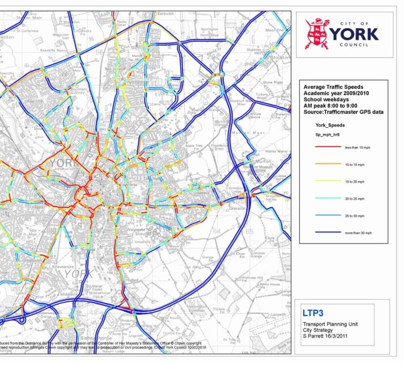
Figure 10 York AM Average traffic speeds 2009/10 .......................................................... 55
Figure 11 Weekday Journey movements into York ........................................................... 56
Figure 12 University of York campuses ............................................................................. 59
HESLINGTON PARISH NEIGHBOURHOOD PLAN

1 Introduction
The Heslington Parish Neighbourhood Plan (HPNP) will form part of the statutory
development plan together with the emerging City of York Local Plan1, hereinafter called
the York Draft Local Plan, when adopted. Planning applications must be determined in
accordance with the statutory development plan unless material considerations indicate
otherwise.

The HPNP covers a 15 year period and has been developed against a background of change
within the political framework of the City of York Council (CYC), the lack of a definitive
Green Belt and the emergence of a York Draft Local Plan.

Heslington Parish Council will review the HPNP periodically to ensure that it remains up-to-
date and that it is effective in shaping development management decisions taken by CYC.
The plan will be revised as necessary.

The York Draft Local Plan covers the period up to 2032/33 with the exception of the Green
Belt boundaries, which will endure up to 2037/38. The York Draft Local Plan sets out how
much and where land should be provided to accommodate the new homes and jobs that
are needed in York. It should also facilitate new infrastructure to ensure that development
is sustainable and protects and enhances the natural and built environment and heritage
of York. Once finalised and adopted, the York Draft Local Plan will be used to manage
development through the determination of planning applications, making it clear where
development is acceptable and to help provide certainty for the local community that the
development planned is co-ordinated.

1
  City of York Local Plan was submitted to the Secretary of State for Housing, Communities and Local Government on
Friday 25 May 2018 for independent examination..

                                                                                                        Page 1 of 68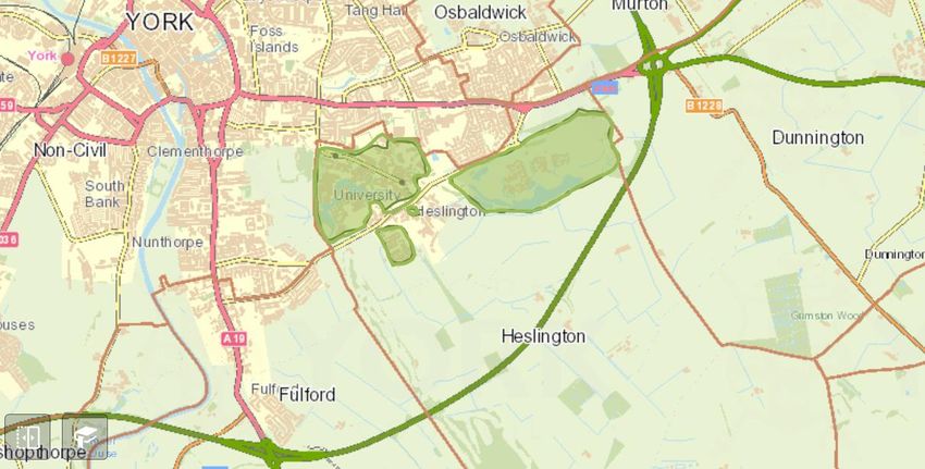
HESLINGTON PARISH NEIGHBOURHOOD PLAN

2 Preparation of the Neighbourhood Plan
The Parish Council approved the development of the HPNP in order to reflect the views of
residents and stakeholders in influencing planning matters within the Parish area.
The designated area, which follows the Parish boundary, was formally approved on 22
November 2016.

HESLINGTON NEIGHBOURHOOD PLAN DESIGNATED AREA AGREED BY THE CITY OF
YORK COUNCIL 22 NOVEMBER 2016.

Figure 1 Neighbourhood Plan Boundary

City of York reference map licence 1000 20818
Crown copyright. Property of the City of York Council and used under agreement.

Heslington Parish Council set up a Working Group to be responsible for the development
of the HPNP in compliance with the Localism Act 2011. The Neighbourhood Plan Working
Group is a sub-committee of the Parish Council with clear terms of reference. The Working
Group has worked with professional consultants specialising in this field and with
assistance from CYC Planning Department.

The work has been part-funded through a series of grants from Locality (an organisation
responsible for overseeing the allocation of funding for the development of
Neighbourhood Plans) and CYC.

                                                                                  Page 2 of 68
HESLINGTON PARISH NEIGHBOURHOOD PLAN

The HPNP was developed in consultation with village residents, local organisations, local
businesses and landowners and the University of York. Progress of the work was reported
to the Parish Council at their monthly meetings. Details of minutes, meetings, consultation
questionnaires and supporting documents are available on the Heslington village website
https://www.heslington.org.uk/neighbourhood-plan/

Newsletters and survey questionnaires with feedback forms were also widely distributed.

Environmental screening of policies and proposals within the draft Neighbourhood Plan
has been carried out.

                                                                                Page 3 of 68
HESLINGTON PARISH NEIGHBOURHOOD PLAN
3 What the Plan aims to Achieve
The aim of the Plan is to influence change in Heslington Parish, not to prevent it.
By working with residents, the University of York and other local stakeholders, future
developments will be welcomed but need to be sympathetic and protect the historic
character and rural environment of the area.
The draft Neighbourhood Plan sets out a clear direction for the Parish that has been
developed and agreed by the people and businesses in the area.
The most important aims are set out below:
Strengthen the historic character, rural setting and core village identity
Support new development of appropriate housing, without compromising the
unique qualities of the built and natural environment
Protect the rural, open character and green spaces of the Parish from inappropriate
development
Support those types of businesses and employment developments that meet the
needs of the community whilst retaining the essential nature of Heslington village
and its surroundings
Improve the choice and sustainability of traffic flows (vehicular, cycle and
pedestrian) to enhance the quality of life for those who live, work, study or do
business in the Parish
Support and enhance the sense of community by improvements in infrastructure
and facilities
Foster effective and positive working relationships with all local stakeholders to
achieve a balance between the unique identity of Heslington as a rural village, the
proximity of a thriving university and opportunities for growth
Summary of Policies
POLICY AREA Purpose
Business, To promote employment opportunities in Heslington that help to create
Employment and sustainable life-work balance.
Local Facilities To maintain and enable a balanced range of local community facilities to
meet local need.
Agriculture and rural To ensure the working farms in Heslington Parish are viable, thriving
enterprise businesses, whilst making a positive contribution to the Parish’s green
infrastructure.
Urban Design and To ensure that new development incorporates sustainable design and
Character complements the distinctive characters of Heslington.
Housing To ensure that new housing development is sustainable and meets local
need.
Page 4 of 68HESLINGTON PARISH NEIGHBOURHOOD PLAN
Designations: Local To ensure that that local Green Space is valued and protected.
Green Spaces
Green Infrastructure To protect and enhance Heslington’s green environment for current and
future generations.
Transport and To ensure that new development is supported by a balanced mix of
Movement sustainable transport options and does not have an adverse impact on traffic
safety and congestion.
University of York To enable the ongoing sustainable development of the University of York as
(Special Policy Area) a major educational, cultural, social and economic asset.
To achieve exceptional design and environmental quality, creating an
environment with a distinctive sense of place, helping to attract students
nationally and internationally.
To reconcile the development of the campuses with protection of the
character, setting and amenities of Heslington village.
Additional To capture other relevant guidance not included above.
Guidelines
Page 5 of 68HESLINGTON PARISH NEIGHBOURHOOD PLAN
4 Heslington - Evidence and Data
This section provides a reference for anyone using the plan. It forms a basis for policies.
Evidence and data to support this plan have been taken from a number of sources:
Data from and reference to the York Draft Local Plan
Technical data from CYC and the University of York
Census data 2011
In addition, information was gained through surveys with:
Local residents
University staff, undergraduate and post graduate students
Local Businesses, landowners and other stakeholders
Evidence can be both quantitative (facts and figures such as census data) as well as
qualitative (opinions given in consultation responses, input from local organisations and
voluntary groups e.g. Heslington Village Trust and where relevant organisations and bodies
responsible for protecting the historic and natural environments) and is used to support
the development of the policies in the HPNP.
5 Strategic Context
Heslington Parish is located approximately 2 miles to the south east of the historic city of
York. York Minster is visible from parts of the Parish. The core of the village is a significant
Conservation Area with its important listed buildings and many green spaces.
5.1 Planning Context
5.1.1 Local Plan
There is no adopted Local Plan for the City of York, although work continues with the York
Draft Local Plan. CYC submitted the York Local Plan to the Secretary of State for Housing,
Communities and Local Government on Friday 25 May 2018 for independent examination.
The CYC Strategic Housing Market Assessment Addendum (2017) has updated the
demographic baseline for York based on the July 2016 household projections, giving an
objectively assessed housing need of 867 new dwellings per annum for the plan period to
2032/33. This includes any shortfall in housing provision against this need from the period
2012 to 2017 and for the post-plan period to 2037/38.
5.1.2 Village Design Statement (VDS)
Following extensive consultation Heslington Village Design Statement was produced and
adopted as Supplementary Planning Guidance in 2004. The HPNP incorporates appropriate
elements of the VDS in its evidence base and in its policies. Thus, the HPNP will supersede
the VDS and gives statutory force to its principles. The VDS is available on the CYC website.
https://www.york.gov.uk/downloads/file/3239/heslington_village_design_statement
Page 6 of 68HESLINGTON PARISH NEIGHBOURHOOD PLAN
5.1.3 Green Belt
From York Draft Local Plan 1.49 and 1.50
“CYC covers approximately 27,200 ha. Of this, around 4,500 ha are built-up area, with the
remainder being open countryside”.
“The majority of land outside the built-up areas of York has been identified as draft Green
Belt within the York Draft Local Plan since the 1950s, with the principle of York’s Green Belt
being established through a number of plans including the North Yorkshire County
Structure Plan (1995-2006) and the Yorkshire and Humber Plan: Regional Spatial Strategy
to 2026 (2008). The overall purpose of York’s Green Belt is to preserve the setting and
special character of York.”
“While the Regional Strategy for Yorkshire and Humber has otherwise been revoked when
the Regional Strategy for Yorkshire and Humber (Partial Revocation) Order (2013) came
into force, its York Green Belt policies were saved… ”
“It is therefore the role of the York Draft Local Plan to define what land is in the Green Belt
and in doing so establish formal detailed Green Belt boundaries.”
Heslington Parish (including the village, which is washed over draft Green Belt, but
excluding most of Campus East and Campus West) is recognised and treated as Green Belt.
This status has been vital in ensuring that the village and its surroundings maintain their
unique rural feel, despite proximity to York and the University.
5.1.4 York Draft Local Plan Preferred options
From the York Draft Local Plan 3.13
“The Plan seeks to identify sufficient land to accommodate York’s development needs
across the plan period, 2012-2033. In addition, the Plan provides further development land
to 2038 (including allowing for some flexibility in delivery) and establishes a Green Belt
boundary enduring for at least 20 years.”
The HPNP welcomes this clear position on Green Belt and the protection it gives to the
historic setting and character of the village of Heslington and the wider Parish area.
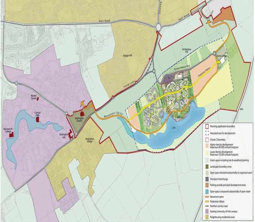
5.1.5 York Draft Local Plan Strategic site allocations
In the York Draft Local Plan, Heslington Parish will be delivering substantial growth for the
city on three major sites together with a new open space:
Page 7 of 68HESLINGTON PARISH NEIGHBOURHOOD PLAN
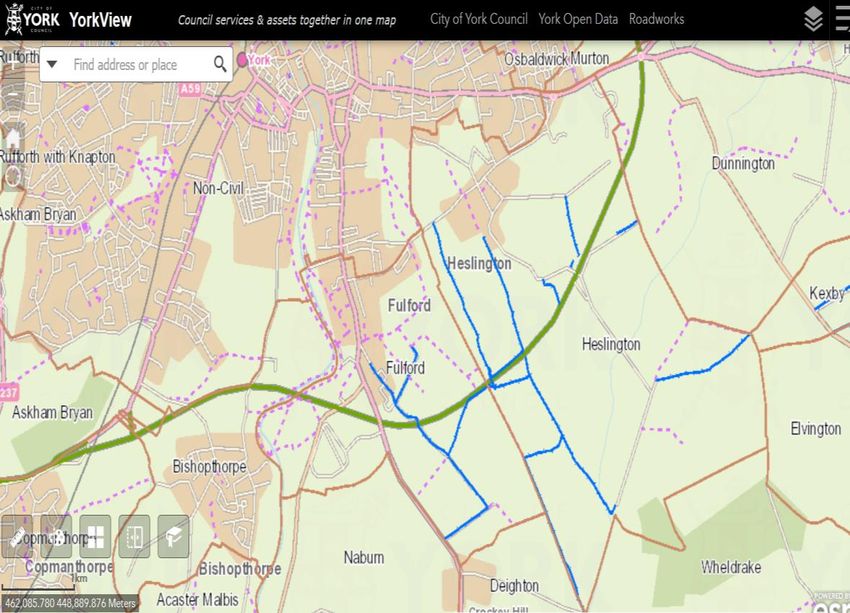
OS10
Figure 2 York Draft Local Plan - 2018 Proposal Map South
(All maps produced within this plan are the property of the CYC and used under a licence agreement with CYC Planning Department)
OS10 New open space is identified on land to the South of the A64 in association with
ST15.
ST4 Land adjacent to Hull Road will deliver approximately 211 dwellings at this urban
extension development site.
ST15 The development of Land West of Elvington Lane approximately 3,339 dwellings,
around 2,200 of which will be constructed in the Parish.
ST27 University of York proposed expansion which will provide 21,500sqm of B1b
employment floorspace for knowledge based businesses including research-led
science park uses and other higher education and related uses.
Page 8 of 68HESLINGTON PARISH NEIGHBOURHOOD PLAN
5.2 Heslington village location within the City of York.
Heslington village is now unique amongst York’s immediately peripheral settlements.
Despite the proximity of the University, the integration of the village within the original
settlement is of great historical importance. Heslington has retained its ‘village’ identity
and rural charm because it has largely maintained its visual and physical setting, sense of
community and shared green spaces. The village has avoided being submerged by
suburban high-volume house building. Continuation of farming on the land in and around
the village is fundamental to its identity. Importantly, the village also provides an attractive
environment for the University of York.
The village has 21 listed buildings and many green spaces e.g. the open area alongside Boss
Lane and Church Field. There are public Rights of Way through both the Campus East and
Campus West of the University.
5.3 Landscape setting
The Parish of Heslington outside the University is largely farmland. It is part of the Vale of
York with a major trunk road (A64) bisecting the area East to West. The Tillmire Site of
Special Scientific Interest (SSSI) and The Outgang common land are of particular
importance.
Virtually the whole Parish, excluding the University, is recognised and treated as draft
Green Belt by local planning authorities.
There are two Ancient Monuments in the Parish.
The agricultural land is predominantly Grade 2.
There is risk of flooding in the Parish, with small portions of Zone 3b, particularly to the
South and East of the village, some Zone 3a, particularly to the south of the A64 and a
larger Zone 2 risk surrounding these two areas.2
CYC has developed the concept of green wedges which bring the countryside into the city.
Village open spaces connect to the area of common land known as Walmgate Stray to form
one of these important green wedges.
5.4 History and character
Heslington has been a settlement since before the Domesday Book. The village now, with
its layout of streets, lanes, footpaths and surrounding paddocks, reflects its slow growth
over the ensuing centuries and by the end of the C19 the pattern of urban form that we
see today was established. Architecturally, the village buildings show a remarkable
consistency of form, materials and details giving the village a cohesiveness, identity and
sense of place.
2
https://flood-map-for-planning.service.gov.uk/confirm-
location?easting=462634&northing=450249&placeOrPostcode=YO10%205DT
Page 9 of 68HESLINGTON PARISH NEIGHBOURHOOD PLAN
5.5 Plan development
The University of York has just over 20,000 students and staff; about 4,1003 of these
students are short-term residents of the Parish and live in Halls of Residence in the Parish.
There are some 2,000 direct employees in York Science Park (hereafter referred to as “the
Science Park”). There are about 700 residents in the village and surrounding farms and
businesses.
Policies have been developed to reflect the needs of all who live, work or do business in
the area and included joint meetings between the University and the HPNP Working
Group.
5.6 The University of York
The University of York, founded in 1963, is consistently in the top 20 ranking universities
nationally for teaching quality and research. A member of the Russell Group 4 of UK
Universities, it plays a significant role in the economic and cultural life of the city and the
region, contributing some £240m annually to the York economy, and generating around
2,780 direct University jobs and 3,700 indirect jobs (based on 2011/12 figures).5
It occupies a 197 ha parkland site on the south eastern edge of York, entirely within
Heslington Parish. Expansion beyond the boundaries of the original Campus West to form
Campus East, at 112 ha, was approved in September 2007 by the Secretary of State.
5.7 York Science Park
The Science Park provides high specification, managed business accommodation to over
150 companies largely in the science and technology sectors. This 8.5 ha park with its close
links to the University of York plays a pivotal role in the technology transfer and business
development for York’s knowledge, bioscience and IT enterprises. It is managed by York
Science Park Ltd (YSPL).
5.8 Wider socio-economic and environmental context
York falls within two socio-economic areas: the Leeds City Region and the York Sub Area.
These areas are overlapping but self-contained functional areas that were originally
defined in the now partially revoked Yorkshire and Humber Regional Spatial Strategy.
York’s wealth of historic attractions provides the cornerstone of the city’s visitor economy.
The city grew as a major centre for the wool industry, and during the C19 its growth was
based around the city becoming a hub within the national rail network as well as a centre
3
Based on last census, there are current more halls of residence and a larger student population
4
The Russell Group represents 24 leading UK universities which are committed to maintaining the very best
research, an outstanding teaching and learning experience and unrivalled links with business and the public
sector
5
Source: City of York Local Plan - Pre-Publication Draft (Regulation 19 Consultation February 2018)
Page 10 of 68HESLINGTON PARISH NEIGHBOURHOOD PLAN
for manufacturing and confectionary. In more recent times, the city’s economy has moved
towards being based on service industries including both tourism and knowledge-based
industries. The city has a number of key sectoral strengths. These include: the healthcare
and bioscience sectors, rail, environmental and bio-renewable technologies, IT and digital
companies, creative industries and financial and professional services. There is significant
employment in chocolate manufacture and the railways. York is the base for two of the
largest building companies in the UK. Higher and further education institutions in the city
(including the University of York) play an important role both in terms of being major
employers in their own right, supporting over 8,000 jobs and providing a skilled labour
pool of graduates to serve the city’s science, technology and professional services
industries.
The city compares well against similar sized European cities, with its highly skilled
workforce, although it is not as productive per capita.
In summary the City of York 6:
Supports nearly 116,000 jobs (NOMIS, 2016)
Contributes £4bn of value to the national economy
Attracts 7 million visitors per year
Ranks highly in various competitiveness indices – for example 20th out of the UK’s
largest 64 cities based on indicators in the Huggins UK competitiveness Index
(2016)
Employs 31% of people in the public sector (above average) (Centre for Cities 2015)
Has a lower than average enterprise and productivity which is 86% of the national
average
The Oxford Economics’ Forecast (OEF) 2014-2031 shows that over the period to 2031
employment will grow by over 10,500 and will add £2.3bn to Gross Value Added. This
means the York economy will be 50% bigger by 2031.
The York Economic Strategy 2016-20 (2016) sets out the vision for York to be a great place
to live, work, study, visit and do business.
Key long term targets include: to have wages above the national average by 2025, business
space and housing required to be fully met, priority high value sector growth and
employment rate, skills plus connectivity advantages maintained.
5.9 Socio-Economic Characteristics
5.9.1 Population Characteristics
The presence of the University of York in the Parish gives a population with a high
proportion of young people and transient residents. Of the 4,800 people who live in the
Parish about 4,100 are students. A good proportion of these are here for 3 years for 3
6
Source: City of York Local Plan - Pre-Publication Draft (Regulation 19 Consultation February 2018)
Page 11 of 68HESLINGTON PARISH NEIGHBOURHOOD PLAN
academic terms each year. Similarly, the working population is dominated by the
University and the Science Park.
Key statistics7
There were 4,792 people living in Heslington aged 16 and over; most of these were
students. The non-student population was approximately 700.
Heslington had 480 households.
150 households were ‘One Person’. In 65 of these households the person was aged over 65
146 households had children. 26 households were occupied by students.
The two largest ethnic groups were White 74.1% (3,551) and Asian 19.7% (944), the latter
group reflecting the University of York student body.
5.9.2 Employment
Key statistics:
Based on Census 2011 Parish data for those aged 16 to 74:
9.5% (431) were employed in part-time, full-time or self-employed work. 0.4% (20) were
unemployed and 1.5% (67) economically inactive (i.e. not actively seeking work). 2.5%
(113) were retired. When excluding those registered as students from the total data the
percentage of people retired increased to 17.9% and was line with York as a whole at
16.3%.
5.9.3 Land Use
The predominant uses in the Parish are farming, education, the Science Park and
residential housing. Most of the land outside the village and the University is dedicated to
farming.
5.9.4 Housing
The housing stock is an eclectic mix of small C18 and C19 houses which dominate Main
Street, with some larger buildings of the same century: Little Hall, the Manor House and a
working farmhouse. The imposing C16 century Heslington Hall is occupied by the
University. There are two sets of almshouses: Hesketh Almshouses and the cottages at the
south end of Main Street. In the middle of the village, Heslington Court is a sheltered
housing facility run by the Joseph Rowntree Housing Trust. Post-war developments have
added to the housing stock.
5.9.5 Transport routes and links
Heslington is well served with buses as a result of the University presence. During term
time buses from the village are typically better than 10 minute frequency into the city
centre during the day. These give access to a substantial public transport infrastructure in
the centre of York and the railway station. As York is a significant hub for rail traffic, there
7
Source: Heslington Ward Profile supplied by CYC in 2017 based on 2011 census
Page 12 of 68HESLINGTON PARISH NEIGHBOURHOOD PLAN
are excellent links to the rest of the UK by train. There are also good bus links to local areas
(Leeds and the east coast) and other parts of the UK.
The A64 to the South of York provides an excellent link west to the A1 and the motorway
network. To the east it provides access to the coast. It is within reach of both the North
York Moors National Park and the Yorkshire Wolds.
Public transport access into the village from the outlying areas is limited. This promotes an
increase in car journeys to the village.
5.9.6 Infrastructure
The village is well served with telephone and high speed broadband. Recent addition of a
fibre network gives access to even higher speeds. However, in the outlying areas of the
Parish broadband access is very poor.
Page 13 of 68HESLINGTON PARISH NEIGHBOURHOOD PLAN
6 Community and Stakeholder Engagement
6.1 Questionnaires
Questionnaires were sent to five groups:
Residents
Businesses, landowners and other stakeholders
Undergraduate students
Postgraduate students
University staff
All five groups were asked broadly the same series of ‘core’ questions, but with
modifications appropriate to their involvement in the Parish.
6.2 Residents
A single copy of the paper version of the questionnaire was delivered to every household
in the Parish (486 questionnaires). A notice about the survey and the questionnaire were
also available on-line on the Parish Council website. Notices about the Neighbourhood
Plan, the purpose of the questionnaire and how to respond were posted on the Parish
Council notice board.
88 questionnaires were returned, a response rate of 18.1% of eligible households.
There were two kinds of questions – quantitative (‘box-ticking’), and qualitative (requiring
an ‘open’, verbal answer).
6.3 Businesses and Landowners
A single copy of the paper version of the questionnaire was delivered to all businesses and
landowners in the Parish (180 questionnaires). Every effort was made to contact all eligible
businesses and landowners based on information provided by CYC, the University of York,
and the Science Park. A stamped addressed envelope was provided for responses.
39 questionnaires were returned, an overall response rate of 21.7%.
Response rates for specific segments of the community were as follows:
Questionnaires distributed Returned % Return
Businesses/Science Park 153 27 (17.6%)
Working farms 7 2 (28.6%)
Landowners/farmers 5 3 (60.0%)
Other village and Parish 14 7 (50.0%)
Page 14 of 68HESLINGTON PARISH NEIGHBOURHOOD PLAN
The responses to both Resident and Business questionnaires were analysed by a retired
natural scientist with additional input from a retired data-analyst.
6.4 Liaison with University of York
As already indicated, Heslington is unusual (possibly even unique) in hosting a world-class
university within what is still a predominantly rural Parish on two main sites (Campus East
and Campus West). Accordingly, a joint Neighbourhood Plan working group was
established with the University.
6.5 University Undergraduates, Postgraduates and Staff
An electronic version of the questionnaire using Google Forms was circulated by the
University of York to all undergraduates (12,540), postgraduates (4,500) and staff (3,500)
using the internal e-mail system and staff newsletter, irrespective of whether they lived in
the Parish or outside it, making clear that their responses should refer only to their
activities (i.e. work, leisure and using facilities) within the Parish and not the wider City of
York.
Responses were analysed automatically using spread sheets.
Response rates
Undergraduates 278 (2.2%)
Postgraduates 99 (2.2%)
Staff 238 (6.8%)
6.6 Consultation Responses to Questionnaires
Examples of the questionnaires and analysis of the responses are available on the
Heslington village website. https://www.heslington.org.uk/neighbourhood-plan/np-
questionaires/
Common response themes referring to facilities, the advantages and disadvantages of
having a university close by, transport, housing and the green and built environment were
carefully analysed and collated. This provided an important and substantial input to the
policies.
7 Growth Strategy
7.1 Overview
This strategy is based on enabling growth, including the York Draft Local Plan proposed
strategic sites to accommodate the wider growth required in York, together with
consideration of environmental constraints.
Page 15 of 68HESLINGTON PARISH NEIGHBOURHOOD PLAN
7.2 Delivering Growth
The York Draft Local Plan proposes strategic site allocations in Heslington, catering not just
for the needs of Heslington Parish, but also the wider city. This includes allocation for
approximately 3,550 houses across the Parish boundary, with 2,411 of those being within
the Neighbourhood Plan area, providing the housing growth (see Section 5.1.5).
Within the Neighbourhood Plan most of the economic growth will come from the
University of York, the Science Park and businesses within strategic site allocation ST15
(see Section 5.1.5).
The HPNP aims to deliver sustainable development by the following means:
Recognising the strategic site allocations being made by the adopted York Draft
Local Plan and including policies to ensure that such housing is well designed and
served by adequate infrastructure
Enabling and shaping the redevelopment and growth of the University of York
campuses
Conserving the historic character of Heslington village
Enabling and maintaining a balanced mix of uses, including a range of community
facilities
Protecting and enhancing the environment and green spaces through Local Green
Space designations and policies
In addition, the HPNP works within the spatial framework created by different
environmental constraints, including:
Designated natural sites and built heritage
The proposed Green Belt (village ‘wash over’)
Green open space ‘buffer zones’ around the village to protect the landscape and
maintain separation from the University of York
Green wedges
8 Business, Employment and Local Facilities
8.1 Purpose
To promote employment opportunities in Heslington that help to create sustainable life-
work balance.
To maintain and enable a balanced range of local community facilities to meet local need.
8.2 Rationale and Evidence
Paragraph 19 of the NPPF states:
Page 16 of 68HESLINGTON PARISH NEIGHBOURHOOD PLAN
“The Government is committed to ensuring that the planning system does everything it can
to support sustainable economic growth. Planning should operate to encourage and not act
as an impediment to sustainable growth. Therefore significant weight should be placed on
the need to support economic growth through the planning system”.
Paragraph 70 of the NPPF states:
To deliver the social, recreational and cultural facilities and services the community needs,
planning policies and decisions should:
Plan positively for the provision and use of shared space, community facilities (such
as local shops, meeting places, sports venues, cultural buildings, public houses and
places of worship) and other local services to enhance the sustainability of
communities and residential environments
Guard against the unnecessary loss of valued facilities and services, particularly
where this would reduce the community’s ability to meet its day-to-day needs
Ensure that established shops, facilities and services are able to develop and
modernise in a way that is sustainable, and retained for the benefit of the
community
Ensure an integrated approach to considering the location of housing, economic
uses and community facilities and services.”
The York Draft Local Plan states:
“The importance of private service activity is very pronounced when it comes to job
creation over the period to 2030. Just over 13,500 net new jobs are forecast to be created
in York between 2013 and 2030, equivalent to an increase of 12%. Of these, the largest
contribution will be made by professional, scientific & technical activities where almost
3,000 jobs are forecast to be created, accounting for more than 1 in 5 new jobs in York.”
The University of York including the Science Park are at the forefront of this area of
increased jobs.
The spread of businesses and employment within the Parish of Heslington is extremely
diverse.
The University is the major employer supporting 2780 direct University jobs and
3,700 indirect jobs
Within the University campuses there are a number of cafes, restaurants and
shops, businesses and health centre serving University personnel and Heslington
residents.
The Science Park occupies a site within Campus West. This provides purpose built,
high-specification, fully-serviced office, laboratory and meeting space to cutting-
edge businesses in dynamic industry sectors including Creative and Digital Media,
Technology, and Biotechnology. Major buildings include the Innovation Centre, the
Bio Centre, the IT centre and Enterprise House. Much of this is incubator space with
companies staying on average for about 4 years before moving to more permanent
Page 17 of 68HESLINGTON PARISH NEIGHBOURHOOD PLAN
sites elsewhere in the city. Companies on the Science Park gain access to cutting
edge research facilities at the University , including a comprehensive suite of
bioscience laboratories , the UK’s premier Plasma Research Centre and a
Nanocentre hosting one of the world’s most powerful microscopes. On average
there are around 150 businesses employing over 2,000 staff.
In addition to the offices managed by York Science Park Limited (YSPL) there are 6
further blocks of offices owned by the University of York and others. These are
occupied by 14 longer-term tenants and including some University usages.
The Catalyst building is situated on Campus East. This modern site can house up to
48 units aimed at creative, IT and digital sector development and is managed by
YSPL.
In Heslington Main Street [South] there is a Post Office, two banks, two pubs, a
local shop, the Village Meeting Room (in a former Wesleyan chapel built in 1844)
and a residential letting agency. The University also occupies buildings on Main
Street.
Other activities and facilities around the village include:
St. Paul’s Parish church (built in 1857) with offices
Lord Deramore’s Primary School, with a brand-new school building for 200 children
Heslington pre-school group and after-school group
Heslington Scout group and Brownies group
The Holmefield Centre (a communal meeting room and facilities)
Heslington Sportsfield at The Outgang hosting cricket and football teams, its own
clubhouse and an area with children’s play equipment
Fulford Golf Course – employing about 20 staff
Rural based businesses include:
o One working farm in the village
o Nine working farms to the south of the village
o A horse livery business
o Two fishing lake enterprises
o A holiday caravan enterprise
o The western end of Elvington airfield
8.3 Main Street
Main Street8 is the core of the Village Conservation Area, running from the Heslington Hall
roundabout to its junction with Low Lane and Common Lane. As well as residential
properties it is also where many of the important facilities are located. The shops and
businesses all rely on the trade from students and staff at the University and from the
Science Park for a steady stream of trade and this ensures that Heslington residents get the
continuing benefit of these businesses, which could not easily be supported solely by the
local resident population.
8
Main Street has two parts. The stretch that runs north-south through the village, and where most of the
village facilities are located, is usually simply referred to as Main Street, but occasionally as Main Street
[South], a convention adopted in the HPNP. At Heslington Hall, Main Street turns west towards Fulford, and
runs as far as Holmefield Lane and Eden’s Court, where the road becomes Heslington Lane.
Page 18 of 68HESLINGTON PARISH NEIGHBOURHOOD PLAN
Main Street has been described as having two quite different characters. During the day,
particularly during university term time, it is a busy, often very busy road, filled with
pedestrians, cyclists, and cars, vans and lorries (competing for parking places and often
parked on double-yellow lines), all making use of its facilities. In the evening and at night it
reverts to being a quiet rural village street.
The Neighbourhood Plan seeks to reconcile a sensible balance between the competing
demands of a village street designated as part of a Conservation Area and those facilities
required by a thriving, international community of university staff, students and residents.
8.4 York Science Park
This area of high employment is extremely important to York as a driver of growth with its
position alongside the University of York. However, there are few opportunities for
expansion on its current site and future growth in professional, scientific and technical
activities may have to be directed to the Campus East. The survey of businesses showed:
41.0% are considering expanding over the next 5 years
33.3% are currently recruiting
39.2% of their workforce travel to work by car
28.2% could use more parking space. Twelve businesses (60% of those responding
to the question) commented that increased traffic and congestion in the village
could be a problem for their business
25.0% chose Heslington because of location including facilities and transport links
21.1% chose Heslington because of involvement with and access to the University
9.6% chose Heslington for the quality of the environment/ beauty of the area
Thus, Heslington Parish and village, the Science Park and the University of York are inter-
dependant and the importance of balance is clear.
8.5 Travel and Traffic Implications
The University of York Transport Survey 2017 records a notable increase in University-
related traffic during peak hours at the Grimston Bar roundabout and the Green Dykes
Lane/Melrosegate junction with the Hull Road. This, when added to the traffic to and from
the Science Park presents an ongoing problem. The threat from too much road traffic
arising from expansion is clear and so any development must include measures to control
or reduce traffic.
8.6 Use of Local Facilities
The questionnaires circulated to Residents, Undergraduates, Postgraduates and University
Staff explicitly asked about their use of facilities.
The number of respondents using each type of facility in Heslington, excluding facilities on
Campus East and Campus West are summarised in the table below.
Page 19 of 68HESLINGTON PARISH NEIGHBOURHOOD PLAN
Facility Residents Under- and Staff
Post-graduate
students
Post Office 85 243 207
Banks 73 199 168
Local shop 72 293 202
Places of worship 26 22 15
Primary school 8 1 14
Pre- & after-school clubs 6 3 8
Brownies, Scouts etc. 4 11 4
Sports Field, Church Field 42 78 41
Pubs 53 290 190
Village Meeting Room 62 11 10
and/or Holmefield Centre
Golf Club 4 8 5
8.7 Business, Employment and Local Facilities Policies
Policy HES: 1 Main Street - Change of Use
Within the Main Street area, application for changes of use to Retail (A1) 9, Food and
drink (A3, A4) and Medical and other community facilities (D1) will be permitted subject
to:
There being no significant detrimental impact on traffic safety or capacity
There being no significant detrimental impact on the amenities of nearby
residents e.g. by restricting the hours of operation
There is no change of use involving the loss of retail, food and drink, business or
community facilities in Main Street including changes of use of ground floors to
residential use
Proposals to diversify the use of public houses will be supported, providing the use as a
public house remains as part of the mix of uses.
Interpretation
The current mixed commercial and residential character of Main Street [South] should be
9
Town and Country Planning (Use Classes) Order 1987 (as amended)
Page 20 of 68HESLINGTON PARISH NEIGHBOURHOOD PLAN
preserved and any commercial development, while being sensitive to the needs of local
farmers and residents, should not reduce the amenity value for residents.
Policy HES: 2 New Business and Employment Development
New business and employment development will be permitted in the following
locations:
Existing Science Park and business zones on University campuses
Within the strategic designated York Draft Local Plan housing sites, where they
comprise local facilities for the new housing
Within farm complexes, to support diversification, providing there is no
significant adverse impact on traffic safety, congestion or residential amenity
Interpretation
This policy recognises the strategic importance of the business parks and the farming
community. It enables employment close to new housing, to provide local opportunities
and create more sustainable work-life patterns. The policy also enables farm
diversification.
Page 21 of 68HESLINGTON PARISH NEIGHBOURHOOD PLAN
9 Agriculture and Rural Enterprise
9.1 Purpose
To ensure the working farms in Heslington Parish are viable, thriving businesses whilst
making a positive contribution to the Parish’s green infrastructure.
9.2 Rationale and Evidence
9.2.1 National Policy
Paragraphs 95 to 98, 109 and 112 of the NPPF make a number of key points including:
Local planning authorities should recognise the responsibility on all communities to
contribute to energy generation from renewable or low carbon sources
Renewable energy represents an important opportunity for farms to reduce their
energy bills and also to create revenue that can help support farming activity
Local authorities should support diversification and development that enables
farmers to become more competitive and sustainable and diversify into new
opportunities. A key message within the NPPF is the need for economic growth - “A
positive planning system is essential, because without growth, a sustainable future
cannot be achieved”. Therefore, significant weight should be placed on the need to
support economic growth through the planning system
The planning system should contribute to and enhance the natural and local
environment by protecting and enhancing valued landscapes, geological
conservation interests and soils…
Local planning authorities should take into account the economic and other
benefits of the best and most versatile agricultural land when considering
development
9.2.2 Sustainable Farming – Evidence of need
Food security is a crucial issue for now and the future and any actions must ensure
that we do not compromise our ability to feed ourselves
Increases in farm productivity and decreases in impact on the environment are
required
Sustainable development and growth in rural areas supports the integration of
environmental, social and economic objectives. This also meets the needs of a
diverse rural population and ensures equality of opportunity
Maintaining the area’s natural asset base
Farmers and landowners should always be consulted and listened to with regard to
developing the area
Sustainable farming will support the wider community
Not one system of farming is the answer and all should be supported for maximum
benefit to society and the environment
Encouraging links between rural areas and urban centres
Page 22 of 68HESLINGTON PARISH NEIGHBOURHOOD PLAN
9.2.3 The Farms
There are ten working farms in the Parish, one in the village itself and the others to the
south of Heslington. They are a fundamental part of the village’s rural setting.
The farming community continues to face formidable challenges with increasing
regulation, volatile markets and fluctuating farming returns. In response to these
challenges farmers have had to consider the resources available to them and look at new
ways of developing their businesses so that they can grow and remain competitive. This
might include the need for modern agricultural buildings either to meet regulations or to
change the use of existing buildings in order to respond to changing market demand.
A sustainable rural community based on an innovative rural economy and a thriving
farming industry, which is profitable and supports viable livelihoods, underpins sustainable
and healthier communities and enhances the environmental assets that are vital to the
county’s prosperity.
For the farming community priorities include (in no particular order):
Creating thriving localities which meet the needs of their communities, businesses
and their environment
Developing renewable energy that meets the needs of the farm and is appropriate
to the location and renewable resources available
Developing farming enterprises that can meet the challenges of food security
through modernising and becoming more efficient
Diversifying farming enterprises to meet new opportunities such as, inter alia,
business units or tourism
Making provision for the next generation to take on management of farms and to
support this through the provision of affordable housing
Realising the value of the Parish’s environmental assets
Providing access to high-speed broadband
Strengthening farming businesses to help them build profitability and respond to
new opportunities
9.2.4 Farming and evidence on the importance placed on green infrastructure
Local farmers are crucial for the maintenance of the Parish’s green infrastructure, by caring
for existing and sometimes reinstating, hedgerows, ditches, grass field margins and
woodlands.
Agricultural land in the Parish is generally identified as Agricultural Land Classification
grade 2 (very good). Moreover, the area’s soils should be valued as a finite multi-functional
resource which underpins well-being and prosperity. Soil can be a store for carbon and
water, a reservoir of bio-diversity and a buffer against pollution. The NPPF (paras.109 and
112) reflects the importance of the conservation and sustainable management of soils
Page 23 of 68HESLINGTON PARISH NEIGHBOURHOOD PLAN
9.3 Agriculture and Rural Enterprise Policy
Policy HES: 3 Agriculture and Rural Enterprise
New development will be supported where:
It is sited and designed to support and acknowledge the working farms and rural
businesses of Heslington
It ensures that farm traffic is accommodated
It does not compromise farming activities
Interpretation
Application of this policy ensures that the operational requirements of farms and rural
businesses are fully considered when development is proposed for the rural parts of the
Parish.
Page 24 of 68HESLINGTON PARISH NEIGHBOURHOOD PLAN
10 Urban Design and Character
10.1 Purpose
To ensure that new development incorporates sustainable design and complements the
distinctive character of Heslington. This means ensuring that:
Any building works, whether extensions, refurbishments to existing buildings or
new developments, incorporate sound sympathetic architectural and urban design
that is informed by, reflects and complements the distinctive vernacular and
architectural character of Heslington so much valued by the residents of the village
That the historic pattern of development of the village is sustained and enhanced
and not lost nor obscured through lack of understanding and unsympathetic
development
10.2 Rationale and Evidence
The rationale and evidence base is drawn principally from the NPPF, the Heslington
Conservation Area Appraisal, the Village Design Statement and responses to community
surveys.
10.2.1 Conservation Area10
In 1969, when under Selby District Council, the Heslington Conservation Area was
designated in order to protect Heslington’s architectural character and historical interest,
its integrity and the coherence of its built and green environment. Following a review in
2004, the Conservation Area boundary was extended by CYC to include, principally, School
Lane and Lord Deramore’s School and grounds to the east, the fields, paddocks and
allotments to the west of Main Street [South]. Around the same time, CYC formally
adopted the Heslington Village Design Statement as Supplementary Planning Guidance. In
2009, CYC commissioned and accepted an independent Conservation Area Character
Appraisal and this was followed in 2013 by CYC’s Character Area Statement for Heslington
which covered the whole village, not just the Conservation Area. This further emphasised
and stressed the importance of Heslington’s architectural and environmental character
and qualities, including its 21 listed buildings, of which 2 are listed as Grade II*.
10.2.2 National Planning Policy Framework [NPPF]
Paragraph 9 of the NPPF states:
“pursuing sustainable development involves seeking positive improvements in the quality of
the built, natural and historic environment”
It goes on to acknowledge within the core planning principles highlighted in paragraph 17,
that:
10
Further details available can be found at
https://www.york.gov.uk/downloads/file/3488/ca28heslingtonpdf
Page 25 of 68HESLINGTON PARISH NEIGHBOURHOOD PLAN
“planning should always seek to secure high quality design and a good standard of amenity
for all existing and future occupants.”
Paragraph 58 of the NPPF states:
“planning policies and decisions should aim to ensure that developments:
Function well and add to the overall quality of the area, not just for the short term
but over the lifetime of the development
Establish a strong sense of place, using streetscapes and buildings to create
attractive and comfortable places to live, work and visit
Optimise the potential of the site to accommodate development, create and sustain
an appropriate mix of uses (including incorporation of green and other public space
as part of developments) and support local facilities and transport networks
Respond to local character and history, and reflect the identity of local surroundings
and materials, while not preventing or discouraging appropriate innovation
Create safe and accessible environments where crime and disorder, and the fear of
crime, do not undermine quality of life or community cohesion
Are visually attractive as a result of good architecture and appropriate landscaping”
Paragraphs 59 and 60 state:
“design policies should avoid unnecessary prescription or detail and should concentrate on
guiding the overall scale, density, massing, height, landscape, layout, materials and access
of new development in relation to neighbouring buildings and the local area more
generally”
10.3 Character Appraisals
10.3.1 Heslington Conservation Area Appraisal [HCAA]
This Appraisal was drawn up by external consultants for CYC and adopted in April 2009. As
such, it has been used to inform the York Draft Local Plan and its recommendations and
observations have been incorporated in the HPNP.
The Appraisal identifies and describes three distinct character areas of the village, the
qualities of their buildings, other structures and the neutral and negative factors in the
areas. They are:
1 Heslington Lane and Main Street [West]
This character area consists of a through road running across the north of the Conservation
Area with adjacent built areas and open spaces to either side. The road forms a
roundabout at a junction with University Road. To the north the area is interlocked with
the University.
The special interest of this character area is the result of a number of different factors,
including the architectural quality of the buildings, the presence of high front boundary
walls, the relative variety of the buildings in terms of style, size, etc. and the relationship to
the main road and to the University. It includes the most important listed building in the
Parish, Heslington Hall [Grade II*].
Page 26 of 68HESLINGTON PARISH NEIGHBOURHOOD PLAN
2 Main Street [South]
This character area consists of the south leg of Main Street and adjacent roads and areas.
This section of Main Street forms a T junction with Low Lane terminating the southern end
of the Conservation Area.
The special interest of this area is that of the appearance of a main village street. In
contrast to the previous character area, the dominant features here are the wide highway,
enhanced by broad grass verges and trees. The buildings, mostly C19 clamp brick and
pantile, are of similar simple form but many with different eaves and ridge heights. This
area contains the only other Grade II* building, Little Hall, and the vast majority of the
other buildings are either listed Grade II, or identified as making a positive contribution to
the conservation area.
The Appraisal also notes the value of the open agricultural ground and paddocks to the
west of Main Street, which separates it from Holmefield, and thus helps to preserve the
historic pattern of the village.
3 St Paul’s Church and the School
This character area is centred on the church and the school and consists of the areas
associated with Field Lane. The special interest of this area is the openness which serves as
a protective space between the rural setting of the Conservation Area and the built up
areas of the University, the Science Park and Badger Hill.
The urban design principles drawn from the HCCA have been incorporated in the HPNP.
10.4 Urban Design Analysis
The evidence base for the urban design analysis is drawn from the Heslington Village
Design Statement, the HCCA and the results of the surveys of people who live and work in
the village and the University. It focuses on the historic development of the village and
surrounding areas and separately, on the University campuses.
10.5 Consultation responses
The following summary and extracts are taken from the results of the surveys:
1 Summary of findings from Questionnaires
From the surveys (see Section 6.1) it was possible to group the emerging themes and
issues. Within these areas there was strong commonality, some areas of difference or
perhaps difference in emphasis and, at times, conflicting views.
A strong feature of all surveys was the recognition of and value assigned to Heslington’s
rural feel, its access to the countryside and its quality design and architecture. Heslington is
seen to have a good access to the countryside and is well cared for. A key theme was that
proximity to the village provides a peaceful break from university life and that its homely
Page 27 of 68You can also read