TOWN OF MORRISTOWN MUNICIPAL SELF-ASSESSMENT REPORT - Town of Morristown Plan Endorsement Process - Draft 03.10.2020 update
←
→
Page content transcription
If your browser does not render page correctly, please read the page content below
TOWN OF MORRISTOWN
MUNICIPAL SELF-ASSESSMENT REPORT

Town of Morristown Plan Endorsement Process

                   Prepared by:

        Town of Morristown Planning Division

                 Topology NJ, LLC

                     April 2020

                     Page 1 of 63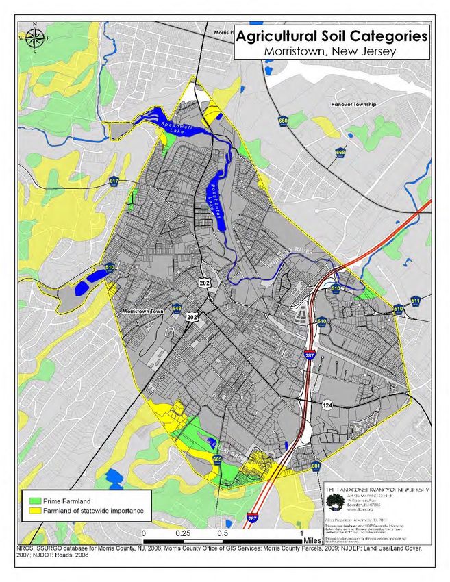
TABLE OF CONTENTS
Page     Section

4        Introduction

5        Location and Regional Context

6        Demographics

9        Community Inventory

16       Community Vision & Public Participation

18       Status of Master Plan and Other Relevant Planning Activities

20       Recent and Upcoming Development Activities

22       Statement of Planning Coordination

23       State Programs, Grants and Capital Projects

24       Internal Consistency in Local Planning

25       Sustainability Statement

26       Consistency with State Plan – Goals, Policies and Indicators

34       Consistency with State Plan – Center Criteria and Policies

36       Consistency with State Plan – Planning Area Policy Objectives

38       State Agency Assistance

39       Conclusion

40       Appendix A: List of Maps

51       Appendix B: Contaminated Sites in Morristown

54       Appendix C: Overview of Zoning Board of Adjustment Applications

                                      Page 2 of 63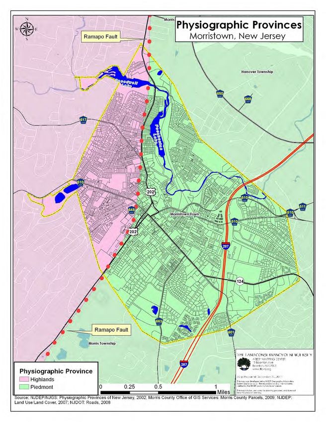
[THIS PAGE IS INTENTIONALLY LEFT BLANK]

                Page 3 of 63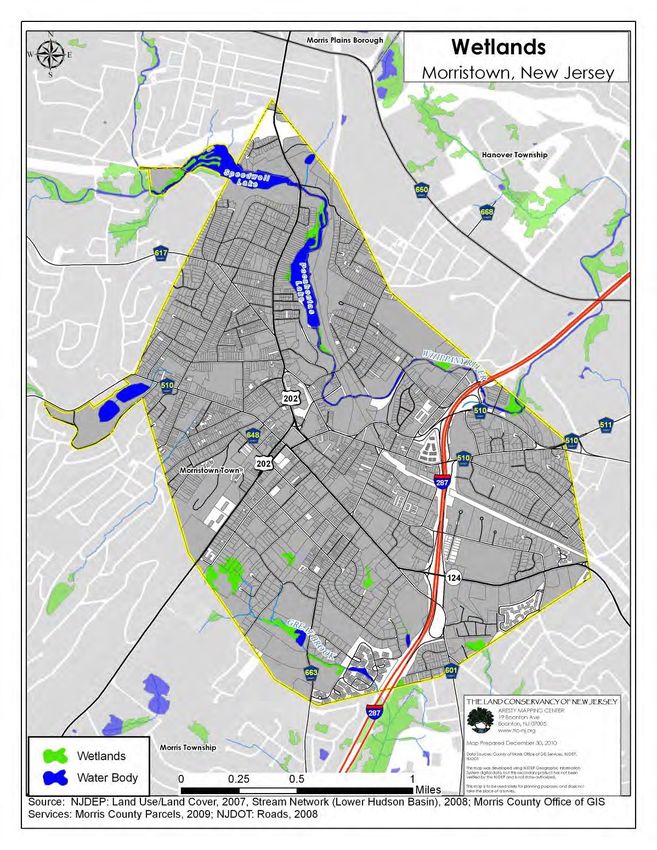
INTRODUCTION
New Jersey’s State Development & Redevelopment Plan (State Plan), adopted in 1992 and readopted in
2001, articulates the State’s long-term goals, policies, and objectives. It guides policy making at and
coordination between all levels of government for housing, economic development, land use,
transportation, natural resource conservation, agriculture and farmland retention, historic preservation, and
public facilities and services. The State Plan allows the State Planning Commission to designate several types
of Centers. These designations promote dense growth to combat sprawl, increase housing inventories,
promote economic development, and enhance the overall quality of life.

Morristown currently is designated as a Regional Center. Originally, its designation was set to expire June 30,
2019. However, amendments to N.J.A.C 5:85-7.21 extended all center designations that expired in 2019 until
June 30, 2020. Morristown presently seeks to renew its Regional Center designation. As a Regional Center,
Morristown has been eligible for aid from the State of New Jersey, such as technical assistance, direct state
capital investment, priority for state grants and low-interest loans, preferential interest rates, and coordinated
regulatory review for projects consistent with endorsed plans. Morristown seeks to continue its access to these
benefits and retune this collaboration with the State to meet its current development and redevelopment
goals.

This Municipal Self-Assessment Report represents Step 3 of 9 in the State Planning Commission’s Plan
Endorsement process. This report is Morristown’s petition for Plan Endorsement and the Town’s review of its
plans for consistency with the State Plan.

Since Morristown was last designated as a Regional Center, the Town adopted a new master plan in 2014,
Morristown Moving Forward, as well as a Master Plan Reexamination Report in 2018. Also, Morristown has
updated many of its other planning documents, which will be enumerated in this report. In particular,
Morristown has adopted a number of new redevelopment plans, currently at various stages in the
redevelopment process, in addition to existing redevelopment efforts. These sites are located in the heart of
Morristown and are vital to the Town’s economic development and trajectory as Morristown positions itself
as a progressive, forward-looking town with regards to land use, design, and community character.
Morristown holds a central place in the region, both economically and historically, and the Town must ensure
that future development accounts for its vast historic inventory, traffic needs on its already busy arterials, and
the preservation of open space.

                                                   Page 4 of 63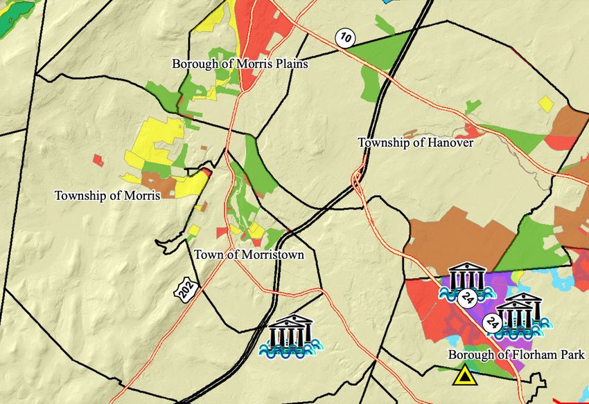
LOCATION AND REGIONAL CONTEXT
Morristown is the county seat of Morris County. A 2.8 square mile enclave within Morris Township, it is located
towards the southeast of the county and within the New Jersey Highlands Region. It is surrounded by several
important open space reserves, such as Washington Valley, Lewis Morris Park, Loantaka Brook Reservation,
and the Great Swamp National Wildlife Refuge. The large woodlands in the region provide Morristown with
valuable recreation spaces and watersheds. Several bodies of water exist within Morristown, including the
Whippany River, Speedwell Lake, Lake Pocahontas, Spring Lake, and Great Brook.

While Morristown is surrounded by valuable and attractive open space, the town is a bustling urban center
for commerce, transportation, and living. The town’s businesses employ over 22,000 people, outnumbering
the number of Morristown residents. Important employment centers in Morristown are the Morristown Medical
Center, Headquarters Plaza, and several other office parks. Those employed in Morristown use U.S. Route 202,
State Route 124, and County Routes 510, which converge at the historic Morristown Green, as well as
Interstate 287, County Routes 601 and 663, and NJ Transit’s Morris & Essex Line for their commutes (See Map
1: Base Map).

A number of maps are included in the Appendices to this Report. These maps help to get a better
understanding of Morristown’s location and importance within a regional context.

                                                 Page 5 of 63
DEMOGRAPHICS

This section is meant to provide a brief background of Morristown’s demographics and how it compares to
that of Morris County and New Jersey in general.

Morristown is a mid-sized community of 18,411 living in 8,172 housing units across four electoral wards. The
downtown workforce totals over 22,000 people, including at least 13,800 office workers. Within the past five
to ten years, Morristown has experienced a renaissance. Local and regional patrons visit Morristown’s many
restaurants, bars, coffee shops, and award-winning Community Theatre. Mixed-use commercial corridors are
within walking distance to residential neighborhoods and consist primarily of shops owned by small business
entrepreneurs. These healthy commercial corridors are on regional transportation networks and connect to,
or intersect at, the Green.

                                   Morristown               Morris County           New Jersey
 Land Area (square miles)          2.8                      482                     7,509
 Population                        18,411                   492,276                 8,791,894
 Households                        7,417                    180,534                 3,214,360
 Average Household Size            2.4                      2.68                    2.68
 Housing Units                     8,172                    189,842                 3,553,562
 Home Ownership Rate               38.60%                   75%                     65.40%
 Vacancy Rate                      9.20%                    4.90%                   9.50%
 Median Household Income*          92,296                   107,034                 76,475
 Per Capita Income*                52,736                   53,491                  39,069
 Poverty Rate*                     7.40%                    4.60%                   10.70%
 Unemployment Rate*                3%                       5.20%                   7%
Source: 2010 Census SF1
*Source: 2017 ACS 5-Year Survey

Morristown’s evolution and recent renaissance are borne out in the demographics. For example, the
population has grown in recent decades and correlates with the economic and social fluctuations of the
times. Also, the ethnic and racial demographics of Morristown continue to evolve, contributing to its cultural
dynamics and richness. As household compositions and demographics change, Morristown is becoming
one of the most welcoming and dynamic communities in New Jersey, offering a rich experience and quality
of life for a wide range of families and household types. The town contains a variety of housing choices,
ranging from single-family homes to townhomes and multifamily apartment buildings. The housing stock
continues to evolve in response to changing demographics and market forces. Morristown is unquestionably
a desirable place to live, work, and play, as the demographics in this section also underline.

                                                 Page 6 of 63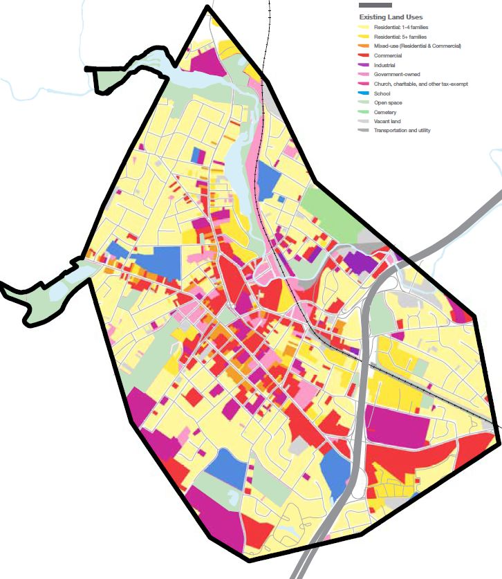
Source: 2010 Census SF 1

                           Page 7 of 63
Source: 2010 Census SF1

                          Page 8 of 63
COMMUNITY INVENTORY

This section provides an overview of Morristown and its built and natural features. As mentioned
before, a number of maps are included in the Appendices to this Report. These maps help to get a better
understanding of the community’s features.

General Information
Located in Morris County, Morristown covers an area of 2.8 square miles and is an enclave entirely surrounded
by Morris Township. The Town is located within the State’s Metropolitan Planning Area (Planning Area 1), with
small sections of the Town part of the Parks and Natural Areas Planning Area.

Planning Area 1 is defined by mature, dense, interconnected settlements with large infrastructural needs and
little developable vacant land. The intent of the Metropolitan Planning Area is to:

    •   provide for much of the state’s future redevelopment;
    •   revitalize cities and towns;
    •   promote growth in compact forms;
    •   stabilize older suburbs;
    •   redesign areas of sprawl; and
    •   protect the character of existing stable communities.

Parks and Natural Areas represent public investment towards resource and recreation space preservation,
and they advance the State Plan’s goal of preserving and enhancing historic, cultural, scenic, open, and
recreational space. The intent of the Parks and Natural Areas delineation is to:

    •   provide for the protection of critical natural resources;
    •   provide public recreational and educational opportunities;
    •   ensure the maintenance of associated facilities; and
    •   ensure the connection of these areas into a system of open lands.

Morristown also lies within two physiographic provinces (See Map 2: Physiographic Provinces). 494 acres of
Morristown are part of the Highlands Special Resource Area (also known as the Highlands region), and 1,429
acres are within the Piedmont Province. The New Jersey Highlands region is about 980 square miles and
entirely or partially includes seven counties and ninety municipalities. Piedmont is a 1,600 square mile region
that comprises about one-fifth of New Jersey. It also stretches through Connecticut, New York, and
Pennsylvania. These regions are defined according to physiographic criteria without considering economic
or political boundaries and is unique for its large amount of environmentally sensitive features. As part of the
Highlands region, Morristown is eligible to participate as a receiving area in the Transfer of Development
Rights Program offered by the New Jersey Highlands Council.

As a regional employment center and an important stop along NJ Transit’s Morris & Essex Line, Morristown is
ripe for growth. However, most land in the town has already been developed. As such, further growth must
come from enhancing the uses and designs of already developed land. Morristown has designated several
areas in need of redevelopment in recent years. These plans are the:

    •   Vail Mansion Redevelopment Plan
    •   Center/Coal Redevelopment Area
    •   Old Lumberyard Redevelopment Area
    •   Train Station Redevelopment Area
    •   Speedwell Redevelopment Plan
    •   Spring Street Redevelopment Plan
    •   Morris Street Redevelopment Plan
    •   Epstein’s Rehabilitation Area
    •   Market and Bank Redevelopment Area

In addition to these redevelopment areas, Morristown also has a Transit Village centered around the
Morristown Train Station. In the 2014 Morristown Master Plan, the town also laid out several “Plans for Places.”
In addition to the above areas, Plans for Places proposes enhancements to the area around the Town Green,
South Street, and Washington Street.

                                                  Page 9 of 63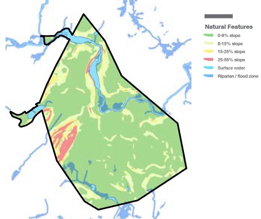
Natural & Cultural Features

Morristown contains various valuable natural features as well as historic and cultural sites.

The following table displays Morristown’s inventory of bodies of water, specifically lakes, rivers, and streams,
as well as their size and classification (also see Map 3: Wetlands).

             Name                                 Acres                           Classification
 Speedwell Lake                                     19                               FW2-NT
 Pocahontas Lake                                   14.5                              FW2-NT
 Footes Pond                                       2.6                               FW2-NT
 Burnham Park Pond (1)                              4                                FW2-NT
 Burnham Park Pond (2)                              3                                FW2-NT
 The Whippany River                                NA                                FW2-NT
 Great Brook                                       NA                                FW2-NT

The 2007 Land Use/Land Cover data from the New Jersey Department of Environmental Protection
(hereafter: NJDEP) records 29 acres of wetlands in Morristown. The below table displays the Town’s wetlands,
their size, and their percentage of the total municipal area (See Map 3: Wetlands).

         Type of Wetlands                          Acres                    % of Total Municipal Area
 Deciduous Wooded Wetland                           26                                  1%
 Herbaceous Wetland                                  2
Morristown is located near the Highlands mountain range. However, Morristown itself is mostly flat. Its few
steep slopes are located along the western border of the town (See Map 5: Natural Features).
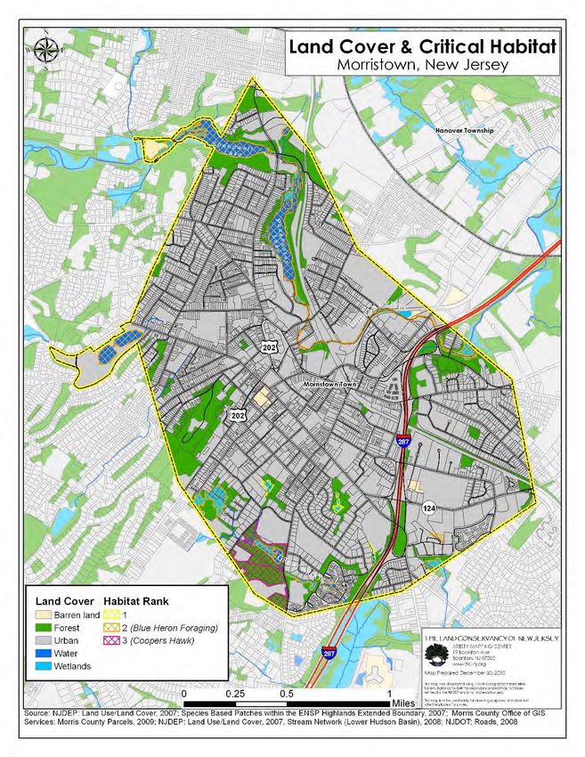
82% of the land cover in Morristown is defined as urban by the NJDEP. The remaining land cover is forest
(13%), Water (3%), Wetlands (2%), and barren land (1%). This non-urban land does contain habitat patches
of ranks 1-3 as defined by the NJDEP. However, only ranks 3-5 are environmentally significant according to
the NJDEP (See Map 6: Land Cover & Critical Habitat). The majority of these habitat patches (85 acres) are
rank 2, where Great Blue Heron have been observed foraging. The 29 acres of rank 3 habitat are all located
in and around Footes Pond Park, where the State threatened species Coopers Hawk has been observed.
Rank 1 land comprises only 3 acres.
Morristown’s Environmental Resource Inventory Update in 2011 recorded approximately 128 acres of “prime
farmland” and “farmland of statewide importance,” as defined by the United State Department of
Agriculture. However, none of this arable land is used for agriculture (See Map 7: Agricultural Soil Categories).
The Town’s historically and culturally significant sites are visualized on Map 8: Historic Resources.
The Federal Emergency Management Agency (FEMA) maps Special Flood Hazard Areas throughout the
United States. These lands are adjacent to streams or rivers and experience flooding during periods of high
discharge. The floodplain is an important part of the river ecosystem for aquatic habitats, water quality, and
groundwater recharge. These floodplains are subject to increased regulation in order to project avoid loss of
life and property damage. Most of Morristown’s floodplains are located in the north, along the Whippany
River, but a small floodplain is also found along Great Brook in the south (See Map 9: Flood Hazard Areas).
The table below comes from the Town’s 2011 Environmental Resource Inventory and presents what types of
floodplains are present in Morristown, their size, and their percentage of the total municipal area.
Flood Hazard Acres % of Total Municipal Area
100-year Floodplain 91 5%
500-year Floodplain 15 1%
Source: Preliminary FEMA DFIRM
Community Facilities
Due to its important role as a regional center, Morristown has a wide variety and significant number of
community facilities serving the various needs of a diverse community.
Morristown is a part of the Morris School District, which also services Morris Township and Morris Plains. The
school district has ten public schools, including one middle school and one high school. The information
below was made available for each school through the New Jersey Department of Education’s 2017-2018
School Performance Reports. These reports include enrollment trends by grade from the 2015-2018.
Page 11 of 63Alexander Hamilton Elementary School Normandy Park School
Grade 2015-16 2016-17 2017-18 Grade 2015-16 2016-17 2017-18
3 127 105 101 KG 51 57 52
4 89 131 105 1 50 47 55
5 94 83 130 2 58 45 46
Total 310 319 336 3 60 60 38
4 61 59 58
Alfred Vail School 5 54 66 56
Grade 2015-16 2016-17 2017-18 Total 334 334 305
KG 98 106 84
1 101 103 106 Lafayette learning Center
2 119 104 101 Grade 2015-16 2016-17 2017-18
Total 318 313 291 PK 163 129 112
Frelinghuysen Middle School Morristown High School
Grade 2015-16 2016-17 2017-18 Grade 2015-16 2016-17 2017-18
6 394 350 342 9 485 478 459
7 385 389 354 10 428 479 451
8 373 387 385 11 467 391 456
Total 1,152 1,127 1,081 12 386 446 392
Total 1,766 1,794 1,758
Hillcrest School
Grade 2015-16 2016-17 2017-18 Thomas Jefferson School
PK 14 0 0 Grade 2015-16 2016-17 2017-18
KG 92 107 95 3 101 111 103
1 97 92 114 4 93 103 118
2 105 100 85 5 97 93 104
Total 308 299 292 Total 291 307 325
Sussex Avenue School Woodland School
Grade 2015-16 2016-17 2017-18 Grade 2015-16 2016-17 2017-18
3 105 108 99 KG 87 108 73
4 97 98 106 4 98 98 107
5 102 96 99 5 102 98 96
Total 304 302 304 Total 287 304 276
There are also several private and parochial schools within Morristown. These include:
• Morristown-Beard School
• Delbarton School
• Fusion Academy
• Shephard Preparatory High School
• The Red Oaks School
• Assumption School (parochial)
• The Peck School (parochial)
There are four nursing and senior care facilities in Morristown: CareOne at Madison Avenue (151 Madison
Avenue), Atlantic Rehabilitation-Morristown (95 Mt Kemble Avenue), Morris Hills Center (77 Madison Avenue),
and Spring Hills at Morristown (17 Spring Place).
With regard to daycare centers, the New Jersey Department of Children and Families provides a list of
childcare centers in each municipality in the State. Below is a table of childcare centers (excluding those in
the Morris School District), along with their addresses, the ages they serve, and their licensed capacities.
Page 12 of 63Name Address Ages Licensed
Served Capacity
Bayer Children’s Center 25 Whippany Road 0-13 120
Children on the Green 50 South Park Place 0-13 87
Children’s Corner 475 South Street 0-13 200
Cradles to Crayons 26 Headquarters Plaza 0-13 120
Cradles to Crayons Childcare Center 16 Pine Street 0-6 140
HeadStart Community Program of Morris County, Inc. 540 W Hanover Avenue 2.5-6 60
Morristown Neighborhood House 12 Flagler Street 0-13 290
Presbyterian Church in Morristown N.S. 65 South Street 2.5-6 64
Rabbinical College of America 226 Sussex Street 0-13 145
Shalom Yeladim Nursery School 177 Speedwell Avenue 2.5-6 60
Success for all Family Programs at St. Peter’s 107 South Street 6-13 81
Temple Bnai Or Pre-School 60 Overlook Road 2.5-6 63
The Montessori Children’s Academy 6-10 Kahn Road 2.5-6 125
The Salvation Army Day Care Center 95 Spring Street 0-6 85
Infrastructure
As the county seat and an employment center of Morris County, Morristown is well-linked to the region by
road and rail (See Map 10: FHWA Classifications). Interstate 287 runs north-south through the east of town,
connects Morristown with NJ State Route 24, the New York State Thruway near the New Jersey-New York
border, and southern end at the Outerbridge Crossing to Staten Island, where it terminates. The highway also
connects I-80, located several miles north of Morristown, with I-78, 15 miles to the south, as well as to I-95.
Several arterial roads meet at the Morristown Green. NJ State Route 124 begins at the Green and runs
southeast out of town, changing from South Street to Madison Avenue by Interstate 287. US Route 202
(Speedwell Avenue/Mt. Kemble Avenue) runs north-south through Morristown and around the Green. County
Route 510 (Morris Street/Washington Street) passes the Green moving east to west. County Route 663 (James
Street), intersects South Street and leaves town due south. Lastly, Morristown Station along NJ Transit’s Morris
& Essex Line provides Midtown direct service to New York Penn Station and service west as far as
Hackettstown.
Today, the predominant travel patterns in Morristown are east-west, with large numbers of travelers passing
through town in the morning to reach I-287 and employment destinations in Bergen, Essex, Hudson, and
Passaic counties, as well as New York City, and returning in the evening. Morristown’s major east-west
corridors are (1) the Speedwell Avenue/Spring Street/Morris Street corridor and (2) the Washington
Street/South Street corridor. Near the town Green, Speedwell Avenue (which also provides north-south
access to the town), meets Spring Street at Headquarters Plaza. Spring Street is used as a bypass around
the Green and terminates at its junction with Morris Street. Morris Street serves as the main roadway
connector for neighborhoods northeast of Morristown, as well as a direct connection to northbound I-287
and, via Ridgedale Avenue, to southbound I-287. Lafayette Avenue parallels Morris Street and serves as its
westbound one-way pair in the immediate vicinity of I-287. Lafayette Street is directly accessible from both
northbound and southbound I-287 via exit ramps, making this a key thoroughfare for commuters.
Underutilized Land
A number of redevelopment plans have been adopted in recent years in addition to the designation of one
rehabilitation area. A short description of each of these plans and designations is included below, specifying
the site’s size, current status and, where relevant, the date of designation.
A. Vail Mansion Redevelopment Plan
This redevelopment plan was adopted in 1998 and involved the adaptive reuse of an historic structure into
residential homeownership units and commercial space. It has been fully implemented.
B. Center/Coal Redevelopment Area
Planning for the Center/Coal Redevelopment Area began several decades ago with community-driven
process led by the Concerned Citizens of the Second Ward (CCSW). A Redevelopment Plan for the area,
adopted in 2006 called for 150 – 200 residential units to be developed in the oxbow of the Whippany River.
In the decade prior to the 2006 redevelopment plan, the CCSW spearheaded the remediation of an
abandoned junkyard and coal gasification plant in the redevelopment area, although limited subsurface
contamination remains on sites within and around the oxbow.
While the location of this seven-acre tract of land suggests that this redevelopment area is ripe for residential
or mixed-use development, it is subject to severe flooding. During Hurricane Irene in 2011, floodwaters from
Page 13 of 63the Whippany River inundated the entire redevelopment area. Since the historic flood events of 2011, FEMA
has developed new flood hazard maps to replace the 1986 maps in place at the time of Hurricane Irene.
FEMA has completed and released preliminary Flood Insurance Rate and Flood Hazard Maps but has yet to
formally adopt those maps. The Center/Coal Redevelopment Plan, and attendant land uses, should be
revisited once official FEMA maps have been adopted.
C. Old Lumberyard Redevelopment Area
The former lumberyard site at the intersection of Elm Street and Morris Avenue was designated an ‘area in
need of redevelopment’ in 2006 but no plan has since been prepared for the property. The property was
redesignated as an “area in need of redevelopment without condemnation” in 2016. As of the time of the
writing of this reexamination, no development has progressed on the site. This site, and adjoining parcels that
were formerly part of the lumberyard operation is an unprecedented opportunity to create a gateway for
Morristown that is connected to the NJ Transit station and regional roadways and would bring new economic
and social activity to the area around the Station. This site is a designated “area in need of redevelopment,”
but no plan has been prepared. See Chapter 4 of the Morristown Moving Forward for detailed design
guidelines for future planning efforts.
D. Train Station Redevelopment Area
Directly adjacent to the Morristown Train Station, these 2.3 acres of land across four parcels and a right-of-
way to be vacated are integral to the Town’s broader redevelopment efforts. The Train Station
Redevelopment Area was designated by the Town Council in December 2006, and March 2007. In
December 2018 the Town approved a Redevelopment Plan for this property. The Plan allows for a maximum
of 85 units, with on-site parking for residents and the public, ground floor retail, a network of public spaces,
and streetscape improvements to create a more hospitable pedestrian environment.
E. Speedwell Redevelopment Plan
The Speedwell Avenue Redevelopment Plan was adopted in 2007 and amended in 2011, 2012, 2015, and
2019. The plan prioritizes Smart Growth tenets, including dense mixed-use development, strategic open
space, and pedestrian friendly design. The first two phases of the Plan, 44 Modera and 55 Modera, are
complete and added several hundred units of residential development to Morristown. A portion of Phase
Four of the Redevelopment Area was redeveloped with a CVS Pharmacy that was completed in 2016. The
Plan was amended in 2019 to clarify the yield potential of the remainder of Phase Four and add design
standards for this Phase. The Town is actively pursuing the creation of open space on site in furtherance of
the Plan. The total buildout potential of the Plan is 554-572 residential units, 36,100 square feet of retail, and
at least 742-762 off-street parking spaces.
F. Spring Street Redevelopment Plan
The Spring Street Redevelopment Plan was adopted in 2008 but has only been implemented on a single
property at 42 Spring Street, on which a multi-family residential development was approved in 2016 and is
expected to begin construction in 2018. A concept plan for development on the remaining properties was
included as part of an overall redevelopment scheme for the train station area in the Plans for Places section
of Morristown Moving Forward. In furtherance of the recommendations of the Master Plan, the
Redevelopment Plan was amended in 2019 to permit the conversion of an existing shopping center into a
mixed-use office campus with over 350,000 square feet of office and ground floor retail. This plan prioritizes
the pedestrian environment and circulation improvements. The project associated with this Plan
amendment is currently being reviewed by the Planning Board. The total build out of the Plan incorporating
the currently pending project and the balance of the plan area is roughly 162 units plus the project currently
in front of the Planning Board.
G. Morris Street Redevelopment Plan
The area was declared an area in need of redevelopment in 2007, and The Morris Street Redevelopment
Plan was adopted in October 2012. Multifamily residential redevelopment projects on the two parcels
included in the Morris Street Redevelopment Plan were completed in 2016. The maximum units permitted
under this plan was 74. In 2019, the Morris Street Phase II Redevelopment Plan was adopted by the Town.
The Plan calls for the creation of 85 units, ground floor commercial and coworking space, on-site affordable
units, and live-work space. The project corresponding to this Plan was approved by the Planning Board in
January 2019.
H. Epstein’s Rehabilitation Area
The Epstein’s rehabilitation area has been completely implemented. Development of 59 residential units with
ground-floor retail on the last remaining property on DeHart Street, known as Parcel C, was approved in
December 2015, began construction in 2016, and was completed in 2018.
I. Market and Bank Redevelopment Area
Page 14 of 63At just over half an acre, the Market and Bank Redevelopment Area is the smallest of Morristown’s
redevelopment areas. Formerly Subarea C of the Epstein’s Rehabilitation Area, this area was designated ‘in
need of redevelopment’ in 2014. A redevelopment plan for the three parcels at the intersection of Market
Street and Bank Street was adopted in April 2015 and revised in April 2016. A five-story office development
was approved for Parcel A in April 2015 and completed in 2017. Redevelopment on the remaining Parcels B
and C as a six-story apartment building with retail at the ground floor was approved in July 2017, and
construction on the project began in 2018. Maximum development associated with this Plan is 50,000 square
feet of office, 25,000 square feet of non-residential ground floor space, and 55 units.
The tables including in Appendix B are part of Morristown’s 2011 Environmental Resource Inventory Update.
These two tables show the present Active Sites with Confirmed Contamination and Pending Sites with
Confirmed Contamination, respectively, in Morristown as of February 15, 2011. These tables present the sites’
ID, the Project Interest (PI) Number and Name, the address, and whether or not the site is a home. There are
currently 38 active sites with known contamination and 6 pending sites with confirmed contamination in
Morristown.
Page 15 of 63COMMUNITY VISION & PUBLIC PARTICIPATION
From the beginning of development of Morristown’s 2014 master plan, Morristown Moving Forward, the
community played a crucial role in developing a vision for the Town’s future. The Town prioritized a
transparent decision-making process, collaborative and accessible public meetings, and participation by
residents.
The Morristown Planning Division established two advisory committees to engage the public, identify key
issues and opportunities and craft solutions: The Municipal Steering Committee (MSC) and the Technical
Advisory Committee (TAC). MSC members included the directors of the Engineering and Building Divisions
and representatives from the Town Council, Planning Board, and Zoning Board. The TAC was led jointly by
Morristown and NJTPA and included officials and stakeholders from outside of Town Hall, including Morris
County, NJDOT, NJTPA, NJ Transit, the Morristown Parking Authority, and the Morristown Partnership.
At the grassroots level, the Town held various workshops and public meetings. A public Kick-Off Event was
held on January 23, 2013 so that the community could help the planning team identify and confirm specific
challenges and opportunities. These responses were used to create and publish a Baseline Report of existing
conditions. April 22, 2013 was “Charrette Week,” a series of workshops, open houses, and presentations held
in a storefront directly on the Green. The planning team relocated to the storefront for the week, and the
public could come to provide feedback, interact with the planning team, and review planning concepts
and drafts of the vision statement, goals, objectives, and the Community Form and Streets Plans. The
storefront was designed to grab the attention of and be attractive to the community to promote
engagement. Outside of the storefront, Sustainable Morristown used two vacant parking spaces as a
temporary “parklet.” The parklets uses and design varied throughout the week to demonstrate its multiplexity
and how the creative use of public space can enhance the pedestrian experience, invigorate public
sidewalks, and spur economic development. Key local stakeholders were also invited to meet with the
planning team to share their unique perspectives within Morristown. This community involvement was vital to
developing the “Plans for Places” chapter of the master plan and identify key issues and opportunities.
Morristown also launched a website (www.MorristownMovingForward.com) in conjunction with the Kick-Off
Event. An interactive website, it allowed the planning team to pose questions to and receive feedback from
the community, post surveys, and provide interactive maps and open forums. The website was an important
tool to increase the reach of the public engagement process. The Kick-Off Event had approximately 500
people in attendance. Meanwhile, between January and August 2013, the website had 175 active
participants (who shared 190 ideas), 1,670 unique visitors, and over 15,500 views. As well, Facebook, Twitter,
email, flyers, and posters were used to promote the website and public workshops.
This commitment to participation has extended to recent redevelopment planning efforts. The two most
recent Redevelopment Plans adopted by the Town (Spring Street Phase 3 Amendment and Morris Street
Phase 2) came after extensive public participation processes that significantly affected the projects.
Ultimately, this public engagement process helped the planning team create its Core Planning Principles for
their work, the master plan, and Morristown’s vision for its future. The principles are as follows:
Equitable Development
1. Civic engagement
2. Housing affordability and mixed-income neighborhoods
3. A diversity of housing types and tenures
4. Equitable access to jobs, neighborhood services, and civic amenities
5. Schools in neighborhoods
6. Local, minority- and women-owned businesses
7. Community safety and neighborhood crime watch
8. Jobs and employment across the socioeconomic
spectrum
Economic Development
1. Commercial development to attract jobs for Morristown residents
2. Redevelopment activities that create jobs for Morristown residents
Page 16 of 633. Mixed-use corridor enhancement and preservation
4. Collaborations with and support for local business
5. Arts and culture as an economic development tool
6. Links between schools with business and government mentorship and learning
7. Economic development that promotes equal opportunity and environmental responsibility
Environmental and Energy Design
1. Pedestrian-friendly streets
2. Public realm improvements
3. Reduced negative impacts of car congestion
4. Architecture and design characteristic of Morristown
5. Green and energy-efficient buildings
6. Transit-oriented, smart growth planning and development
7. Green infrastructure
8. Quality, usable open space
9. Safe access to schools
10. Safe access for seniors and people with disabilities
Morristown’s Core Planning Principles have a strong resemblance with the State Plan’s eight statewide goals:
Morristown’s Core Planning Principles follow and promote the statewide goals of the State Plan relevant to
Morristown. These principles seek to provide all members of the community equal economic opportunity and
access to its public spaces, services, and amenities. The Town strives to promote development that is both
economically energizing and environmentally sustainable, including mixed-use and transit-oriented
development, energy-efficient development, and enhancements to the public realm and open space.
Providing diverse housing options will allow all of Morristown’s current and future residents to find housing that
suits their needs. As Morristown progresses, it will seek to preserve its many historic and cultural sites and
promote architecture and designs that keep the Town’s historic inventory in mind.
Statewide Goals
1. Revitalize the State’s Cities and Towns
2. Conserve the State’s Natural Resources and Systems
3. Promote Beneficial Economic Growth, Development and Renewal for All Residents of New Jersey
4. Protect the Environment, Prevent and Clean Up Pollution
5. Provide Adequate Public Facilities and Services at a Reasonable Cost
6. Provide Adequate Housing at a Reasonable Cost
7. Preserve and Enhance Areas with Historic, Cultural, Scenic, Open Space and Recreational Value
8. Ensure Sound and Integrated Planning and Implementation Statewide
Page 17 of 63STATUS OF MASTER PLAN AND OTHER RELEVANT PLANNING ACTIVITIES
Master Plan
Morristown published its most recent master plan in 2014, Morristown Moving Forward. This master plan
included a mobility & streets plan, a land use & community form plan, and “Plans for Places,” as well as
implementation strategies and a review of its relationship to the plans of its neighboring municipalities,
county, and the State of New Jersey. The Plans for Places chapter applies the policies of the mobility and
land use chapters to specific areas of importance in Morristown as identified by the community at public
meetings. For each of these locations, the chapter discusses the issues to be addressed; reiterates and
expands upon future land use, mobility, and complete streets policies and principles from the previous
chapters; and provides implementation strategies and actions for the municipality. As mentioned in the
Community Vision & Public Participation section of this application, the planning team also developed its
Core Planning Principles as part of its community engagement process for the master plan.
The master plan was re-examined in 2018. The re-examination report served to address any changes in
Morristown’s context in light of past and ongoing planning activities and recommend future changes,
actions, and strategies. This re-examination allows the Town to maintain consistency among its planning
activities and adapt and evolve to changing circumstances. Specifically, this report discussed how the
problems and objectives identified in the 2008 Master Plan Re-examination Report had evolved; identified
changes in assumptions, policies, and objectives of Morristown Moving Forward; recommended changes to
the Master Plan and Land Development Ordinance regulations; and recommended changes to
redevelopment plans.
Land Development Ordinance
In response to the civic engagement received from the Morristown Moving Forward process, the Town
overhauled its zoning ordinance with its 2018 Land Development Ordinance to leverage current best
practices and techniques and to reflect the Town’s current vision for its future. The new ordinance established
a progressive form-based code that is pro-density and sustainable while preserving Morristown’s unique
historic character, sites, and neighborhoods. In addition, the ordinance seeks to provide affordable housing
for low-, middle-, and moderate-income households, promote transit-oriented development, and create
lively and accessible public spaces and streetscapes.
Housing Element & Fair Share Plan
In light of the evolving circumstances and direction of affordable housing and the Council on Affordable
Housing in New Jersey, Morristown updated the housing element of its master plan and address its Fair Share
Obligations in 2018, in compliance with the Municipal Land Use Law and the New Jersey Fair Housing Act.
Morristown is committed to providing opportunities for affordable housing development within its borders.
The Town has an inclusionary zoning ordinance, which requires new development to include affordable
housing units or to contribute significant payments in lieu to the Affordable Housing Trust Fund. The plan
incorporates data to illustrate trends in demographics, housing conditions, employment, and land use. The
plan also lays out its prior round obligation, present need, and prospective need for housing for low- and
moderate-income households as part of its Fair Share Obligation, as well as the specific sites that supply
housing towards these needs. The total number of affordable households for each category are 138, 16, and
369, respectively.
Complete Streets Policy
In 2012, Morristown updated its Complete Streets Policy, which enumerates ten goals to provide a long-term
vision to create an integrated, comprehensive, and safe multi-modal network for non-automobile traffic. The
Policy also includes an Action Plan to direct action on the Policy. The Policy is accompanied by a Complete
Streets Checklist to assist project planning, design and development and construction and maintenance of
publicly funded projects.
Morristown Bicycle Plan Addendum
An expansion of Morristown’s 2009 Bicycle Plan, this addendum was produced with the assistance of the
New Jersey Department of Transportation (NJDOT) – Office of Bicycle and Pedestrian Programs. A bicycle
compatibility assessment of roadways and intersections in the Town using NJDOT guidelines, an analysis of
reported bicycle crashes, and the identification of regional and local bicycle facilities and trip generators
were completed. These studies were used to create recommendations for on-road bicycle facility
Page 18 of 63improvements, an implementation plan, and preliminary cost estimates. The addendum seeks overcome
Morristown’s narrow roadways, high traffic volumes, and dense development in order to provide improved
bicycle facilities to the Town’s growing bicycling community.
Environmental Resource Inventory
The Environmental Resource Inventory details Morristown’s geology, hydrology, ecology, and wildlife in order
to help the Town understand the scope and condition of its vital resources and improve the Town’s quality
of life. Supported by a plenitude of data tables and maps, the inventory addresses the Morristown’s
physiographic regions, soils and slopes, water resources, wetlands, land cover and land use, critical habitats,
and known contaminated sites, as well as the effects of climate change on the Town. This document is an
important tool for the Town as it tries to balance its development needs with its open space preservation
goals and the impacts of Climate Change.
Redevelopment Plans
For details on Morristown’s redevelopment plans, see the “Underutilized Land” section of the Community
Inventory. Morristown’s recent Redevelopment Areas and Plans are as follows:
• Vail Mansion Redevelopment Plan
• Center/Coal Redevelopment Area
• Old Lumberyard Redevelopment Area
• Train Station Redevelopment Area
• Speedwell Redevelopment Plan
• Spring Street Redevelopment Plan
• Morris Street Redevelopment Plan
• Morris Street Redevelopment Plan Phase II
• Epstein’s Rehabilitation Area
Page 19 of 63RECENT AND UPCOMING DEVELOPMENT ACTIVITIES
This section contains a description of all major development activities that have occurred recently in
Morristown. The input for this section is derived from the annual reports of the Morristown Zoning Board of
Adjustment from 2014 through 2018. These reports provide the name of the applicant(s), the application
number, the block and lot of the site as defined by Morristown’s tax map, the approval date (if applicable),
and what action was taken on the application. The reports include site plan and subdivision applications.
In addition to those applications approved by the Morristown Zoning Board of Adjustment, recent
redevelopment plans also constitute a category of important development activities. The following
redevelopment plans have been described in detail in preceding sections of this report.
• Vail Mansion Redevelopment Plan
• Center/Coal Redevelopment Area
• Old Lumberyard Redevelopment Area
• Train Station Redevelopment Area
• Speedwell Redevelopment Plan
• Spring Street Redevelopment Plan
• Morris Street Redevelopment Plan
• Morris Street Redevelopment Plan Phase II
• Epstein’s Rehabilitation Area
A short summary of the 2014, 2016, 2017 and 2019 annual reports on applications brought to the Morristown
Board of Adjustment is included below. The full list of approved applications and a detailed description of
each application is provided in Appendix C.
2014
Total Applications Acted Upon: 30
Total Applications for Extensions: 0
Total Applications for Interpretations: 1
Total Applications Granted: 29
Total Applications Denied: 1
Total Applications Withdrawn: 2
2016
Applications Acted Upon: 32
Total Applications for Extensions: 0
Total Applications for Interpretations: 0
Total Appeals from Decision of Zoning Officer: 0
Total Applications Granted: 32
Total Applications Denied: 0
Total Applications Dismissed: 1
Total Applications Withdrawn: 4
2017
Applications Acted Upon: 21
Total Applications for Extensions: 0
Total Applications for Interpretations: 0
Total Appeals from Decision of Zoning Officer: 0
Total Applications Granted: 21
Total Applications Denied: 0
Total Applications Dismissed: 0
Total Applications Withdrawn: 1
2019
Applications Acted Upon: 15
Total Applications for Extensions: 1
Total Applications for Interpretations: 0
Total Appeals from Decision of Zoning Officer: 0
Page 20 of 63Total Applications Granted: 14
Total Applications Denied: 0
Total Applications Dismissed: 0
Total Applications Withdrawn: 1
Page 21 of 63STATEMENT OF PLANNING COORDINATION
Morristown is cognizant of its role within the broader region. As a county seat and Regional Center, the Town
is sensitive to the impact that its land use decisions have on the surrounding area, and vice versa. This involves
communication and collaboration with partners at different levels of government, as well as in the non-profit
and private sectors.
All of Morristown’s planning efforts take into account consistency with the 2001 State Development and
Redevelopment Plan. As noted elsewhere in this report, we find these efforts to be largely consistent.
Morristown’s relationship with the region is particularly relevant to the Town’s efforts relating to mobility and
circulation. In 2017 the Town drafted Morristown Moving Forward, a mobility plan. This plan took into account
the regional impacts of traffic in Morristown when assessing potential circulation improvements. As an
outgrowth of this plan, the Town has worked with NJDOT to improve the efficiency of signals within the
municipality.
The Town also works with Morris County in various areas. One such area is traffic and circulation. This is
evident in the ongoing review of the project proposed via the Spring Street Phase 3 Amendment. This project
(now known as M Station) calls for the creation of a roundabout at Morris Street and Spring Streets. The Town
has worked with the County to evaluate the efficacy of this roundabout. The Town also participates with the
County in their other planning efforts, including relating to open space and historic preservation. The Town
strives to ensure consistency of planning efforts with the County.
Morristown is cognizant of the impact of its planning efforts on Morris Township, its sole adjacent municipality.
The Morristown Master Plan was reviewed for consistency with the current planning documents for Morris
Township. When drafting Redevelopment Plans, the impact on Morris Township and consistency with the
Townships plans is considered.
The Town also works where possible with non-profit and private sectors. One example is a recent partnership
with TransOptions relating to the installation of a HAWK Beacon to improve pedestrian safety on Speedwell
Avenue. The Town partnered with TransOptions to ensure that there were public education materials
available to ensure residents were aware of how to use this new piece of infrastructure. The Town also works
collaboratively with NJTPA. Presently, the Town is working with NJTPA on Route 202 improvements and
reconstruction of the Martin Luther King Avenue bridge. Finally, while the Town maintains jurisdiction and
control over all planning and land use efforts, the Town works to ensure that plans are feasible for the private
sector, provided they still achieve the municipality’s planning gals.
Page 22 of 63STATE, FEDERAL & NON-PROFIT PROGRAMS, GRANTS AND CAPITAL
PROJECTS
Since 2017, Morristown has received thirteen grants from the State. These include projects such as land
acquisition, streetscape improvements, and police overtime. Most of these projects are funded by the New
Jersey Department of Transportation or the New Jersey Division of Highway Traffic Safety.
The details of each project are enumerated in Appendix D. The appendix provides the funding agency, the
funding program, the name of the project, a brief description of the project, the project’s geographic area,
the amount awarded to the project by the agency, and the start and end dates of the project.
Page 23 of 63INTERNAL CONSISTENCY IN LOCAL PLANNING
Morristown has kept its various planning documents up to date and actively ensures consistency among its
planning documents and activities. The Town’s master plan was updated in 2014 with Morristown Moving
Forward. This master plan also includes a new Mobility & Streets Plan and Land Use & Community Form Plan.
The “Plans for Places” section is an important aspect of the master plan that applies the goals, policies, and
strategies of the previous components of the master plan to redevelopment areas within Morristown, as well
as other key sites within the Town. The community was engaged in the development of the master plan, and
community input was used to develop a new Community Vision for the Town as part of the master plan.
Several planning documents were updated in 2018. The Housing Element of the master plan was updated
alongside the Town’s Fair Share Plan. This document incorporates the ideas of the master plan and details
the role of Morristown’s redevelopment sites in achieving its affordable housing needs, and is reflective of the
Town’s agreement with the NJ Fair Share Housing Center. As well, Morristown Moving Forward was re-
examined. This report ensures continuity between the Town’s planning activities by addressing the status of
problems and objectives identified in the 2008 Master Plan Re-examination Report; changes in assumptions,
policies, and objectives from Morristown Moving Forward; and recommends changes to the master plan, the
Land Development Ordinance, and the Town’s redevelopment plans. Subsequently, Morristown adopted a
new Land Development Ordinance, which incorporates the progressive policies and objectives of the master
plan, its re-examination, and the Community Vision to create a forward looking ordinance that protects
Morristown’s historic character while incorporating pro-density, pro-development, and transit-oriented land
use that is sustainable and promotes lively streetscapes and open space. The Land Development Ordinance
also provides an updated zoning map.
Most of the Town’s planning documents have been updated since the adoption of Morristown Moving
Forward in 2014. Documents that have not been updated since 2014 include Morristown’s Bicycle Plan (2010),
Environmental Resource Inventory (2011), Complete Streets Policy (2012), and the Morris Street
Redevelopment Plan (2012). The first three documents share the forward looking, sustainable goals that have
been incorporated into the master plan, and Phase Two of the Morris Street Redevelopment Plan is still in
planning stages and will be drafted with consideration of the Town’s other planning activities. As well,
Morristown’s Historic & Cultural Inventory needs to be updated. This need has been addressed in the master
plan and its re-examination, and both of these documents emphasize this need in order to better implement
the town’s historic preservation goals.
All of Morristown’s redevelopment plans are consistent with the Town’s other planning documents. Each
redevelopment plan analyzes its relationship to other relevant municipal plans.
Page 24 of 63SUSTAINABILITY STATEMENT
Morristown actively and consciously works to ensure that its planning policies and strategies will allow its future
generations of residents and businesses to prosper. Morristown has received the Sustainable NJ Bronze
Certification, and the Town’s Environmental Commission has collaborated with Sustainable Morristown to
streamline efforts with the Town’s administration towards renewing its certification. Morristown’s master plan,
Core Planning Principles, and Land Development Ordinance support mixed-use, transit-oriented, and green
development, as well as lively and inviting streetscapes and open spaces. In addition, the Town preserves
and expands its diverse portfolio of housing employment options.
Morristown’s redevelopment plans actively target underutilized and deficient sites in the Town to convert
them into higher-intensity, attractive, and modernized spaces. These redevelopment sites include residential,
commercial, office, and hotel space, consider pedestrian and vehicle traffic in their designs, and provide
open space and enhanced sidewalks to the whole community. A good example of these development
strategies is the Spring Street Redevelopment Area. Ground-floor retail will generate foot traffic along Morris
and Spring Streets. The construction of a roundabout will increase traffic capacity while also reducing
vehicular greenhouse gas emissions. As well. It’s attractive design and revitalized space will connect the
Green to the train station, incentivizing non-vehicular travel.
These development practices and principles prepare Morristown for the future. These comprehensive
strategies provide the Town, its residents, and stakeholders with opportunities for economic development
that is environmentally friendly and creates a vibrant community.
Page 25 of 63CONSISTENCY WITH STATE PLAN - GOALS, POLICIES & INDICATORS
This section contains a table for each of the eight goals and underlying strategies of the State Plan, aligned
with relevant policies and indicators. The content in these tables is quoted directly from the State Plan. Each
table is accompanied by an analysis describing in detail how this report is consistent with that particular goal
and how it supports the State’s efforts to achieve its targets for specific indicators.
GOAL POLICIES INDICATORS
Goal 1: Revitalize the State’s Cities and Policy on Urban Revitalization - Prepare Key Indicator 5. Progress in
Towns strategic revitalization plans, socioeconomic
neighborhood empowerment plans revitalization for the 68
STRATEGY: Protect, preserve and develop and urban complex strategic municipalities eligible for
the valuable human and economic assets revitalization plans that promote Urban Coordinating Council
in cities, towns and other urban areas. Plan revitalization, economic development assistance
to improve their livability and sustainability and infrastructure investments,
by investing public resources in coordinate revitalization planning Indicator 6. Percent of jobs
accordance with current plans which are among organizations and located in Urban
consistent with the provisions of the State governments, support housing Coordinating Council
Plan. Leverage private investments in jobs programs and adaptive reuse, improve municipalities
and housing; provide comprehensive access to waterfront areas, public
public services at lower costs and higher open space and parks, and develop Indicator 23. Percent of
quality; and improve the natural and built human resources with investments in building permits issued in
environment. Incorporate ecological public health, education, work force Urban Coordinating Council
design through mechanisms such as solar readiness and public safety in cities and municipalities
access for heating and power generation. towns.
Level the playing field in such areas as Indicator 27. Number of
financing services, infrastructure and Neighborhood
regulation. Reduce the barriers which limit Empowerment Plans
mobility and access of city residents, approved by the Urban
particularly the poor and minorities, to jobs, Coordinating Council
housing, services and open space within
the region. Build on the assets of cities and
towns such as their labor force, available
land and buildings, strategic location and
diverse populations.
Analysis
• The Town’s nine redevelopment plans and areas leverage private resources to create dense, mixed-
and single-use developments that increase the Town’s housing stock, including affordable housing,
and create places that invite pedestrian activity to invigorate new, diverse businesses. These projects
also provide infrastructure enhancements that connect different areas of the Town. Redevelopment
is done through an open process that invites cooperation from all stakeholders.
• The Plans for Places section of the Master Plan recommends policies for key locations in Morristown
with unique development potential through infrastructure improvements and targeted
development strategies.
• The Open Space and Recreation Plan and the Environmental Resource Inventory both identify and
protect the Town’s environmental resources and waterfronts located in parks and greenways that
provide residents with pristine open space and waterfront access throughout the Town. Patriots’ Path
and the Traction Line Recreational Trail provide connections to residents from surrounding
municipalities to come to Morristown.
• The Housing Element and Fair Share Housing Plan furthers Morristown’s efforts to provide a diverse
housing stock and fulfill its affordable housing needs to ensure that Morristown is accessible to all
groups of people.
Page 26 of 63GOAL POLICIES INDICATORS
Goal 2: Conserve the State’s Natural Policy on Water Resources – Protect and enhance Key Indicator 2. The
Resources and Systems water resources through coordinated planning amount of land
efforts aimed at reducing sources of pollution and permanently
STRATEGY: Conserve the state’s other adverse effects of development, encouraging dedicated to open
natural resources and systems as designs in hazard-free areas that will protect the space and farmland
capital assets of the public by natural function of stream and wetland systems, and preservation
promoting ecologically sound optimizing sustainable resource use.
development and redevelopment Key Indicator 3.
in the Metropolitan and Suburban Policy on Open Lands and Natural Systems – Protect Percent of New
Planning Areas, accommodating biological diversity through preservation and Jersey’s streams that
environmentally designed restoration of contiguous open spaces and support aquatic life
development and redevelopment connecting corridors; manage public land and
in Centers in the Fringe, Rural and provide incentives for private land management to Indicator 11.
Environmentally Sensitive Planning protect scenic qualities, forests and water resources; Conversion of
Areas, and by restoring the integrity and manage the character and nature of wetlands for
of natural systems in areas where development for the protection of wildlife habitat, development
they have been degraded or critical slope areas, water resources, and for the
damaged. Plan, design, invest in provision of adequate public access to a variety of Indicator 26. Percent
and manage the development and recreational opportunities. of land in New Jersey
redevelopment of Centers and the covered by adopted
use of land, water, soil, plant and Policy on Coastal Resources – Acknowledge the watershed
animal resources to maintain statutory treatment of the coastal area under management plans
biodiversity and the viability of federal and state legislation, coordinate efforts to
ecological systems. Maximize the establish a comprehensive coastal management
ability of natural systems to control program with local planning efforts, undertake a
runoff and flooding, and to improve regional capacity analysis, protect vital ecological
air and water quality and supply. areas and promote recreational opportunities.
Policy on Special Resource Areas – Recognize an
area or region with unique characteristics or
resources of statewide importance and establish a
receptive environment for regional planning efforts.
The Highlands region has been recognized as the
first Special Resource Area in New Jersey.
Analysis
• The Environmental Resource Inventory identifies key natural resources in Morristown to facilitate their
protection and to define development patterns that do not adversely affect these resources through
mechanisms such as the Land Development Ordinance.
• The Open Space and Recreation Plan protects the Town’s natural resources, water resources,
wetlands, and critical habitats as parks and greenways. Morristown’s greenways and trails, in
addition to walking and biking paths laid out in the Town’s Mobility & Streets Plan and Bicycle Plan
Addendum, connect the town’s natural resources to one another as well as with the rest of the Town
to allow residents easy access to enjoy these natural resources.
• The Town’s various redevelopment plans promote sustainable development, such as effective
stormwater management systems, that do not adversely affect natural resources.
• Morristown seeks to remediate its Active Sites with Confirmed Contamination and catalogues them
in its Environmental Resource Inventory.
Page 27 of 63You can also read