Water for life and livelihoods - Part 1: South East river basin district River basin management plan Updated: December 2015
←
→
Page content transcription
If your browser does not render page correctly, please read the page content below
EB 08.40

Water for life and livelihoods

Part 1: South East river basin
district
River basin management plan
Updated: December 2015

LIT 10317

We are the Environment Agency. We protect and improve the
environment and make it a better place for people and wildlife.
We operate at the place where environmental change has its greatest
impact on people’s lives. We reduce the risks to people and properties
from flooding; make sure there is enough water for people and wildlife;
protect and improve air, land and water quality and apply the
environmental standards within which industry can operate.
Acting to reduce climate change and helping people and wildlife adapt to
its consequences are at the heart of all that we do.
We cannot do this alone. We work closely with a wide range of partners
including government, business, local councils, other agencies, civil
society groups and the communities we serve.

Contacts
For more details about river basin management plans contact:
Andrew Pearce, Area Manager
Email: Southeastrbd@environment-agency.gov.uk
You can also call the National Customer Contact Centre:
South East River Basin Management Plan
Bradmarsh Business Park, PO Box 544 Rotherham, S60 1BY
03708 506506 (local rate) Monday to Friday 8am to 6pm

Published by:                  Further copies of this report are available
Environment Agency             on the river basin management plan web pages
Horizon House
Deanery Road
                               (https://www.gov.uk/government/collections/river-
                               basin-management-plans-2015).
Bristol
BS1 5AH                       and via our National Customer Contact Centre:
www.gov.uk/environment-agency T: 03708 506506
                                     Email:
                                     enquiries@environment-agency.gov.uk.

© Environment Agency 2016 All rights reserved. This document may be reproduced with
                          prior permission of the Environment Agency.

 South East river basin management plan. Part 1                                       2
Contents
     Using the plan: accessing the most relevant information ................................................... 4
1.      Introduction ..................................................................................................................... 5
     1.1. The purpose of a river basin management plan .......................................................... 6
     1.2. Who is responsible for implementing this plan ............................................................ 7
     1.3. The South East river basin district .............................................................................. 9
     1.4. Significant water management issues....................................................................... 11
     1.5. Working with others .................................................................................................. 13
     1.6. Links to other major plans affecting water management ........................................... 15
     1.7. Reporting progress on this plan ................................................................................ 16
2. Current state of the environment, environmental objectives and outcomes............... 17
     2.1. Current state of the environment .............................................................................. 18
     2.2. Environmental objectives .......................................................................................... 20
     2.3. Preventing deterioration............................................................................................ 21
     2.4. Protected area compliance and objectives................................................................ 22
     2.5. Water body objectives .............................................................................................. 26
     2.6. Reversal of trends .................................................................................................... 30
     2.7. Progressive reduction of pollution of groundwater .................................................... 30
     2.8. Environmental outcomes for 2021 ............................................................................ 31
3. Measures to achieve the environmental objectives ...................................................... 34
     3.1. Programme of measures: background ...................................................................... 35
     3.2. Measures to prevent deterioration ............................................................................ 37
     3.3. Main programmes of measures for 2021 outcomes .................................................. 49
     3.4. Local measures ........................................................................................................ 60
     3.5. Forward look at measures beyond 2021 ................................................................... 71
     3.6. Additional measures to achieve protected area objectives ........................................ 76
4. Changes from 2009 to 2015 ............................................................................................. 78
     4.1. Improvements in evidence ........................................................................................ 79
     4.2. Measures implemented ............................................................................................ 81
     4.3. Progress towards achieving the environmental objectives in the 2009 plan .............. 85
5. Summary statistics .......................................................................................................... 89

 South East river basin management plan. Part 1                                                                                      3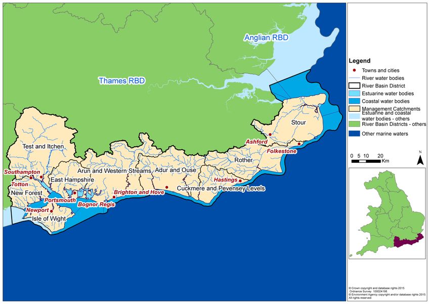
Using the plan: accessing the most relevant information
The river basin management plan consists of a number of different documents, maps and
datasets, of which this is just one. Below is a summary of the statutory components of the
river basin management plan (in blue) along with associated documents and data sources
outside of the official plan that support the plan (in brown):

     The plan - Part 1:           •Current state and pressures on the environment.
     River basin district          Environmental objectives, programme of measures
         summary                   and progress since 2009 plan (This document)

     The plan - Part 2:           •Summary of the technical, economic and engagement
   Planning overview and           processes used to develop this plan. Referred to as
   additional information          'Part 2: RBMP overview'

        The plan:                 •Throughout Part 1 and Part 2 documents there are
      Maps, data and               links to interactive maps, detailed information and
   supporting information          method statements that form part of the plan.

 •The flood hazards and risks, flood risk management           Flood risk management
  objectives and the measures to achieve those                           plan
  objectives.

 •The catchment data explorer is a web application to
  help explore and obtain detailed information                Catchment data explorer
  about local catchments and individual bodies of
  water.

Throughout this document there are light green boxes containing links to the further
information relevant to each section.

 Further information
 • You can access the river basin management plan and associated documents though the river
   basin management web pages (www.gov.uk/government/collections/river-basin-management-
   plans-2015).
 • A guide to accessing river basin management data and supporting information is available on the
   river basin management web pages (www.gov.uk/government/collections/river-basin-
   management-plans-2015)

 South East river basin management plan. Part 1                                                4
1. Introduction

         This section provides an explanation of the purpose
         of this plan, who it is for and how the river basin
         district is managed.

South East river basin management plan. Part 1                 5
1.1. The purpose of a river basin management plan
Water is essential for life and livelihoods. It allows the natural environment to flourish, and
businesses, agriculture and the economy to grow and prosper.
Rivers, lakes, estuaries, coastal areas, wetlands and water under the ground provide many
different benefits to society; from supplying drinking water and supporting fisheries to
providing an essential resource for business and agriculture, transport routes and a source of
recreation that promotes wellbeing.
It is critical that this precious resource is managed properly to ensure that the needs of
society, economy and wildlife can be met and maintained over the long-term.
The purpose of a river basin management plan is to provide a framework for protecting and
enhancing the benefits provided by the water environment. To achieve this, and because
water and land resources are closely linked, it also informs decisions on land-use planning.
This plan contains 4 sets of information that groups who manage land and water should pay
particular attention to:
• Baseline classification of water bodies - One of the main purposes of this plan is to
prevent water bodies deteriorating. The first step to preventing deterioration is to
understand the baseline status for all the quality elements in each water body.
Deterioration from the baseline is not permitted, except in very specific circumstances
that are described in this plan. Preventing deterioration is one of the biggest
challenges in managing the water environment.
• Statutory objectives for protected areas - This plan highlights the areas of land and
bodies of water that have specific uses that need special protection. These include
waters used for drinking water, bathing, commercial shellfish harvesting and those
that sustain the most precious wildlife species and habitats. The plan ensures that
these areas have the legally binding objectives in place that protect those uses from
potentially harmful activities and new developments.
• Statutory objectives for water bodies - This plan sets out legally binding objectives
for each quality element in every water body, including an objective for the water body
as a whole. The default objective is good status. Less stringent objectives have been
set in some cases where natural conditions, technical feasibility or disproportionate
cost make improvement impractical. The default deadline for achieving objectives is
2021. However, extended deadlines of 2027 or beyond have been set in some cases
where it would be more appropriate, have less impact on existing activities or where
the environment will need more time to respond to the planned measures.
• Summary programme of measures to achieve statutory objectives - This plan
provides a framework for action and future regulation. To do this it summarises the
existing mechanisms, both statutory and voluntary, that are used to manage the
quality of the water environment. It also summarises the types of action and who
needs to do this, to achieve the statutory objectives. Although it is not a detailed
action plan it provides a clear signal to those who use and affect water about what
they can do to make sure there is enough good quality water for life and livelihoods in
England.
The river basin management plan has been approved by the Secretary of State for the
Environment, Food and Rural Affairs. It has been prepared in line with Ministerial guidance
and fulfils the requirements of the Water Framework Directive and contributes to the
objectives of other EU directives. It is an update of and replaces the river basin management
plan published in 2009 (referred to as the ‘2009 plan’ in this document).
South East river basin management plan. Part 1 61.2. Who is responsible for implementing this plan
Many organisations are responsible for managing the water environment in the river basin
district. These organisations are often grouped into sectors, such as water companies,
agriculture and industry. Table 1 identifies these sectors and describes their role in
managing the water environment.
The roles in managing the water environment are:
• Regulator - regulates and enforces the activities of operators
• Operator - undertakes activities that could potentially influence either directly or
indirectly the quality of the water environment. Many of these activities are regulated
• Influencer - educates, influences or advises others on how to reduce their impact on
the water environment
• Undertakes projects - undertakes environmental improvement projects (for example,
habitat restoration) to reduce the damage caused by others, usually in partnership
with other groups
Table 1: Main sector groups involved in river basin management
Sector Role in managing the water environment
Regulator Operator Influencer Undertakes
projects
Agriculture and rural land management -
X X X
farming, forestry and horticulture
Government and agencies:
Central government departments X X
Environment Agency X X X X
Natural England X X X X
Forestry Commission X X X
Marine Management Organisation X X
Highways England X X
Network Rail X X
Industry, manufacturing and other
business - including chemicals,
construction, food and drink, power X X
generation, paper, textiles and metals
Internal drainage boards X X X X
Local government - includes local
councils, national park authorities and
X X X X
Inshore Fisheries and Conservation
Authorities
Mining and quarrying - coal mining, non
X X
coal mining and quarrying
South East river basin management plan. Part 1 7Sector Role in managing the water environment
Regulator Operator Influencer Undertakes
projects
Navigation - inland waterways (Canal &
River Trust), port and harbour authorities
X X X X
Non-governmental organisations - user
groups, catchment groups and
X X X
environmental organisations (including local
wildlife trusts and rivers trusts)
Waste treatment, transfer, storage and
disposal - landfill, biowaste, waste X
treatment and transfer
Water industry - water supply and sewage
X X X X
treatment activities
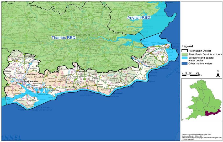
South East river basin management plan. Part 1 81.3. The South East river basin district The South East river basin district (Figure 1) covers over 10,200km2 and extends from Hampshire in the west to Kent in the east. It includes East and West Sussex, the Isle of Wight and parts of Wiltshire and Surrey. In total over 3.5 million people live and work in the south east, which is densely populated and includes the major urban centres of Southampton, Portsmouth, Ashford, Brighton and Hove. The South East river basin district has a rich diversity of wildlife and habitats, supporting many species of global and national importance. These include migratory salmon rivers, native white clawed crayfish, and estuaries and coastal waters important for shellfish, wintering wildfowl, breeding gulls and terns. There are 9 management catchments that make up the river basin district, which include many interconnected rivers, lakes, groundwater, estuarine and coastal waters. These catchments range from chalk streams of the Test and Itchen catchments to the modified rivers of the Rother catchment. Around 65% of the river basin district is used for farming, including livestock, arable and horticultural businesses. Important sectors contributing to the economy of the district include technology, manufacturing, tourism, financial services and construction. To support economic growth and development, significant or large scale infrastructure projects will occasionally take place within the river basin district. These projects must take account of the environmental objectives within this river basin management plan. Similarly, the potential benefits and impacts of such projects will, where relevant, be considered during future reviews and updates of the plan, including updates to the environmental objectives. South East river basin management plan. Part 1 9
Figure 1: Map of the South East river basin district

                         South East river basin management plan. Part 1   10
1.4. Significant water management issues
The significant water management issues are the main issues that limit the uses and
potential benefits of managing the water environment in the river basin district in a
sustainable way. They have been identified based on the results of public consultation and
assessments of the pressures caused by people now, in the past, and predicted in the
future.
Many of these issues arise from current activities that provide a wide range of benefits. It
may therefore not be possible or desirable to fully resolve the issues.
• Physical modifications - affecting 43% of water bodies in this river basin district
People have made many physical changes to rivers, lakes and estuaries, for example, flood
defences and weirs, and changes to the size and shape of natural river channels for land
drainage and navigation. These modifications alter natural flow levels, cause excessive build
up of sediment in surface water bodies and the loss of habitats and recreational uses. In
many cases the uses and associated physical modifications need to be maintained. In these
circumstances it may not be possible to achieve good ecological status.
• Pollution from waste water – affecting 40% of water bodies in this river basin district
Waste water, or sewage, can contain large amounts of nutrients (such as phosphorus and
nitrates), ammonia, bacteria, harmful chemicals and other damaging substances. Sewage
can be the main source of phosphorus and harmful chemicals and of nitrate. It can enter
water bodies where sewage treatment technology to remove enough of the phosphorus and
harmful chemicals doesn’t exist, from leakages from privately owned septic tanks and, in wet
weather, storm overflows can discharge untreated sewage having a significant impact on
bathing waters. Population growth and changes in rainfall patterns are increasing the
pressure on the sewer network.
• Pollution from towns, cities and transport - affecting 9% of water bodies in this river
basin district
Rainwater draining from roofs, roads and pavements carries pollutants, including grit,
bacteria, oils, metals, vehicle emissions, detergent and road salt drains to surface waters,
including estuaries and coastal waters. Many homes and workplaces have 'misconnected'
drains, meaning that dirty water often enters surface waters and groundwater rather than
foul sewer drains.
• Changes to the natural flow and level of water - affecting 7% of water bodies in this
river basin district
Reduced flow and water levels in rivers and groundwater caused by human activity (such as
abstraction) or less rainfall than usual can mean that there is not enough water for people to
use and wildlife might not be able to survive. Reduced flow affects the health of fish and
exaggerates the impacts of barriers such as weirs. Climate change research shows that by
2050 England can expect significant seasonal variations, with higher winter and lower
summer flows, and a reduction in flow overall. In the long term, there will be less water
available to abstract for drinking, industry and irrigating crops.
• Negative effects of invasive non-native species - affecting 2% of water bodies in this
river basin district
Non-native invasive species can have significant economic impacts. The cost of controlling
invasive species to make sure that flood defences and the natural environment are not
compromised is rising. American signal crayfish are becoming widespread and affect
animals such as fish and invertebrates. Other species such as mitten crabs destroy habitats
like reed beds and can cause banks to collapse by burrowing into them. Climate change is
South East river basin management plan. Part 1 11thought to drive certain species northwards, increasing their frequency and variety in the
future and affecting the condition of water bodies.
• Pollution from rural areas - affecting 30% of water bodies in this river basin district
Some approaches to land management have increased the amount of soils and sediment
that are being washed off the land carrying phosphorus into waters which can cause
excessive algae growth called 'eutrophication'. A changing climate means that more intense
rainfall is likely to occur, increasing the risk of impacts further. Nitrate from fertilisers has built
up in groundwater over decades and will take a long time to reduce. Sedimentation from
erosion, forestry practices, saturated and compacted fields and livestock trampling on river
banks has affected river ecology by smothering fish spawning grounds. Other impacts
include bacteriological contamination from animal faeces and inappropriately stored and
applied livestock slurry being washed off the land, pesticides from farming, forestry, golf
courses and parks. These contaminants pose a particular threat to bathing waters, shellfish
waters and drinking water.
Taking account of climate change
The climate is changing as a result of greenhouse gas emissions caused by human activity.
Latest UK climate projections show that temperatures will continue to rise, with increased
winter rainfall and more rain falling in intense storms and continuing sea level rise. The
impact on river flows, water quality and ecosystems is less clear. Studies to learn more
about the effects of climate change on the river basin district are underway. In the meantime,
it makes sense to implement measures that are flexible or increase resilience to extreme
weather events and future warming.
Risk assessments
Risk assessments are used to help identify significant water management issues by
identifying where pressures could change in the future, potentially leading to a deterioration
or reducing the effectiveness of measures to meet their objectives. The Environment Agency
has reviewed and updated, where necessary, the risk assessments since the 2009 plan.
The risk assessments forecast risk up to 2027. Because of the relatively short timescale, the
specific risks from climate change have been considered mainly in the faecal indicator
organisms risk assessment and the abstraction-flow risk assessment.
Further information in this document
• You can find a summary of the impacts of significant water management issues by sector in
section 5.
Information elsewhere in the river basin management plan
• You can find GeoPDF maps, statistics and main findings for each risk assessment on the
Environment Agency's ShareFile Service (https://ea.sharefile.com/d-s6032429bce84ee98)
• More detail on risk assessments and links to the method statements behind them can be found
in section 4.4 of Part 2:RBMP overview (www.gov.uk/government/collections/river-basin-
management-plans-2015).
• The Inventory of emissions, discharges and losses of priority and priority hazardous substances
(https://ea.sharefile.com/d-sab675d1e4d74e5e8) provides information on priority substances at
the river basin district scale.
• You can find more detail on how the inventory has been compiled in section 4.4 of Part 2:
RBMP overview (www.gov.uk/government/collections/river-basin-management-plans-2015).
Sharefile links have been updated – please use the guide to accessing data and information to
access files https://www.gov.uk/government/publications/river-basin-management-plans-accessing-
data-and-information-guide
South East river basin management plan. Part 1 121.5. Working with others
River basin district liaison panel
The river basin district has a liaison panel. Members share their views as the representative
of a sector that is responsible for implementing measures and carrying out projects.
The role of the liaison panel is to:
• contribute evidence to enable decision making and reporting on river basin
management plans
• devise and track measures and projects as part of a programme of work to prevent
deterioration and improve the environment
• work with members and their sectors to ensure a broad base for decision making and
communication
• assist and champion the implementation of the catchment based approach
Catchment partnerships and the catchment based approach
Taking a catchment based approach helps to bridge the gap between strategic management
planning at river basin district level and activity at the local water body scale. The catchment
based approach aims to encourage groups to work together more effectively to deal with
environmental problems locally.
Catchment partnerships are groups of organisations with an interest in improving the
environment in their local area and are led by a catchment host organisation. They inform
the river basin management planning process and help implement measures by:
• providing local evidence
• targeting and coordinating action
• identifying and accessing funding for improvements in the catchment
• incorporating river basin management planning into the wider environmental
management of the catchment
Some of the partnerships will produce their own catchment or local plans.
The partnerships work on a wide range of issues including, but not restricted to, the water
environment and river basin management. Catchment partnerships also cover coastal and
marine waters.
Table 2 lists the partnerships in this river basin district. Some partnership groups are in the
early stages of being set up, while others have been active for years. Members from some
catchment partnerships also sit on the river basin district liaison panel.
South East river basin management plan. Part 1 13Table 2: Catchments and partnership groups
Catchment Partnership group host
Adur & Ouse Ouse and Adur Rivers Trust
Arun & Western Streams Arun and Rother Rivers Trust (ARRT)
Cuckmere & Pevensey Levels Sussex Wildlife Trust/ South East Rivers Trust
East Hampshire Groundwork South (Solent)
Isle of Wight Natural Enterprise
New Forest Freshwater Habitats Trust/ New Forest National
Park Authority
Rother Kent Wildlife Trust/ Sussex Wildlife Trust/ High
Weald AONB Unit
Stour Kentish Stour Countryside Partnership/South East
Rivers Trust
Test & Itchen Hampshire and Isle of Wight Wildlife Trust
Incorporating information from others in river basin management planning
Some organisations have asked for the opportunity to share their environmental data to help
improve river basin management and catchment planning. For example, sharing data and
information to improve local evidence on the cause of a problem, such as the reason for not
achieving good status, or a new response to a problem. The Environment Agency is working
with the Catchment Based Approach National Support Group and others to confirm data
sharing priorities. To learn more about sharing your information contact your local catchment
partnership, see further information box.
Further information in this document
• You can find a map showing the location and boundaries of the catchments in section 3.4.
• Contact details for the catchment partnerships as well as a summary of the measures they are
carrying out can be found in section 3.4.
Information elsewhere in the river basin management plan
• You can find more information about the catchment based approach in section 3.4 of Part 2:
RBMP overview (www.gov.uk/government/collections/river-basin-management-plans-2015).
Supporting information
• You can find more information on the liaison panel and details about membership in the Record
of consultation and engagement (www.gov.uk/government/collections/river-basin-management-
plans-2015).
• You can find examples on how the Environment Agency has used information from others in the
consultation response document (www.gov.uk/government/collections/river-basin-management-
plans-2015).
• You can find more information on the catchment based approach on the catchment based
approach web pages (http://www.catchmentbasedapproach.org/).
South East river basin management plan. Part 1 141.6. Links to other major plans affecting water
management
This plan provides a long-term framework for managing the issues that affect the quality of
the water environment in the river basin district. However, many water management issues
are so significant or complex that they demand their own more detailed plans. The public
bodies that prepare these plans are bound by the Water Environment (Water Framework
Directive) Regulations 2013 to have regard to the river basin management plan when
exercising their functions and in the case of many of the functions exercised by the
Environment Agency and the Secretary of State for the Environment, Food and Rural Affairs
to exercise those functions so as to secure compliance with the requirements of the WFD.
Table 3 summarises the important water management issues that have their own planning
processes and plans.
Table 3: Other plans affecting water management
Issue Plans Primary responsible
bodies in England
Flooding and coastal Flood risk management plans Environment Agency
erosion
Local Flood Risk Management Lead local flood authorities
Strategies
Shoreline management plan Coastal groups (risk
management authority
partnerships)
Climate change adaptation UK National Climate Government’s Committee on
Adaptation Strategy and Climate Change
Adaptation Plan
Public bodies and utility
companies
Water supply Water resources management Water companies
plans
Drought management plans
Biodiversity Biodiversity 2020: A strategy Defra
for England’s wildlife and
Natural England
ecosystem services
Natura 2000 site improvement
plans
Invasive non-native species The Great Britain Invasive Defra’s Great Britain invasive
(INNS) Non-native Species strategy non-native species secretariat
and implementation plan
Marine waters Marine Strategy Framework Defra
Directive
Marine Management
Marine plans Organisation
Supporting information:
• More information about the flood risk management plans can be found on the flood risk
management plan web pages (https://www.gov.uk/government/collections/flood-risk-
management-plans-frmps-2015-to-2021).
South East river basin management plan. Part 1 151.7. Reporting progress on this plan
A formal assessment of progress with meeting the objectives in this plan will be reported in
the 2021 update to this plan. An interim report on making measures operational will be
produced and reported to the European Commission in 2018.
The Environment Agency and other organisations have extensive monitoring programmes to
assess the state of the water environment. To help monitor progress with this plan and show
how the quality of the water environment is changing, the Environment Agency will report on
a range of quality indicators. These could include:
• status or risks facing protected areas: drinking water protected areas, Natura 2000
sites, bathing waters, shellfish waters, nutrient sensitive areas
• ecological status plus individual status of some quality elements: fish, macrophytes,
invertebrates, diatoms, phosphorous, dissolved oxygen, ammonia, specific pollutants,
acidity
• chemical status plus individual status of some quality elements
• the annual change in status of each of the individual ecological status elements
This will be used as an indicator of overall progress towards good ecological status.
As well as monitoring the state of the environment, the Environment Agency also plans to
report on important activities that will eventually bring positive results. For example:
• numbers of fish passage improvements
• length of shoreline and river bank habitat enhancements
• area of priority habitat created or improved
• extent of new mitigation measures implemented on heavily modified and artificial
water bodies
Those implementing measures should monitor and report their own progress. The following
groups will be particularly important:
• catchment partnerships - progress on partnership projects, progress on securing
additional funding and influencing others
• water companies - progress on implementing national environment programme
schemes and other measures that relate to environmental performance agreed by the
water company with their customer challenge group
• agriculture and rural land managers - progress on uptake of Countryside Stewardship
schemes that benefit water and other sector related initiatives, for example, Campaign
for the Farmed Environment
• local authorities - opportunities taken to encourage growth by green infrastructure and
habitat enhancement
• ports and navigation authorities - implementing mitigation measures
• Highways England - progress on environmental aspects of their £15 billion road
investment strategy
The liaison panel, as a collective group representing the river basin district as a whole,
provides an opportunity for monitoring progress against the plans, sharing best practice and
helping catchment partnerships. As such, positive actions taken by partners to implement
this plan can be reported and collated through the panels
South East river basin management plan. Part 1 162. Current state of
the environment,
environmental
objectives and
outcomes
This section describes the current state of the
environment and the environmental objectives for the
river basin district. It also describes the planned
progress towards achieving those objectives by
2021.
South East river basin management plan. Part 1 172.1. Current state of the environment
The WFD indicator of the health of the water environment is whether a water body is at good
status or potential. This is an assessment of a range of quality elements relating to the
biology and chemical quality of surface waters and quantitative and chemical quality of
groundwater. To achieve good ecological status or potential, good chemical status or good
groundwater status every single element assessed must be at good status or better. If one
element is below its threshold for good status, then the whole water body’s status is classed
as less than good.
Surface water bodies can be classed as high, good, moderate, poor or bad status. Table 4
gives a description of each of those status classes.
Table 4: Definition of status in the Water Framework Directive
Status Definition
Near natural conditions. No restriction on the beneficial uses of the water body.
High No impacts on amenity, wildlife or fisheries.
Slight change from natural conditions as a result of human activity. No restriction
Good on the beneficial uses of the water body. No impact on amenity or fisheries.
Protects all but the most sensitive wildlife.
Moderate change from natural conditions as a result of human activity. Some
Moderate restriction on the beneficial uses of the water body. No impact on amenity. Some
impact on wildlife and fisheries.
Major change from natural conditions as a result of human activity. Some
Poor restrictions on the beneficial uses of the water body. Some impact on amenity.
Moderate impact on wildlife and fisheries.
Severe change from natural conditions as a result of human activity. Significant
Bad restriction on the beneficial uses of the water body. Major impact on amenity.
Major impact on wildlife and fisheries with many species not present.
Table 5 shows the number of water bodies in the river basin district. It shows whether these
are natural, artificial (such as canals and reservoirs) or have been modified ('heavily
modified') for particular uses.
Table 5: Number of water bodies in the river basin district
Water body categories Natural Artificial Heavily Total
modified
Rivers, canals and surface water transfers 138 13 69 220
Lake 2 16 10 28
Coastal 2 0 9 11
Estuarine 1 5 17 23
Groundwater 33 0 0 33
Total 176 34 105 315
South East river basin management plan. Part 1 18Tables 6 and 7 summarise the current status of surface and groundwater water bodies in the
river basin district.
Table 6: Ecological and chemical 2015 classification for surface waters
Chemical
Ecological status or potential
status
No. of water bodies Bad Poor Mod Good High Fail Good
282 10 60 169 43 0 5 277
Table 7: Chemical and quantitative 2015 classification for groundwaters
Quantitative status Chemical status
No. of water bodies Poor Good Poor Good
33 16 17 16 17
The 2015 water body classification is the baseline from which deterioration is not permitted
unless certain and specific conditions apply.
A summary of the current state of protected areas is included in section 2.4.
Information elsewhere in the river basin management plan
• For more information on how the current status of the water environment is assessed see
section 4 of Part 2: RBMP overview (www.gov.uk/government/collections/river-basin-
management-plans-2015).
• You can access GeoPDF maps showing the current status of water bodies on the Environment
Agency’s ShareFile Service (https://ea.sharefile.com/d-s6032429bce84ee98).
• To obtain the 2015 classification results for each water body, download the water body
spreadsheet (https://ea.sharefile.com/d-s0faa355450243538).
Sharefile links have been updated – please use the guide to accessing data and information to
access files https://www.gov.uk/government/publications/river-basin-management-plans-accessing-
data-and-information-guide
South East river basin management plan. Part 1 192.2. Environmental objectives
The environmental objectives of the WFD are:
• to prevent deterioration of the status of surface waters and groundwater
• to achieve objectives and standards for protected areas
• to aim to achieve good status for all water bodies or, for heavily modified water bodies
and artificial water bodies, good ecological potential and good surface water chemical
status
• to reverse any significant and sustained upward trends in pollutant concentrations in
groundwater
• the cessation of discharges, emissions and loses of priority hazardous substances
into surface waters
• progressively reduce the pollution of groundwater and prevent or limit the entry of
pollutants
Environmental objectives have been set for each of the protected areas and water bodies in
the river basin district. They were identified through a process involving technical and
economic appraisals and formal public consultation. Achieving the objectives will optimise
the benefits to society from using the water environment.
The environmental objectives summarised in this section are legally binding. All public
bodies must have regard to these objectives when making decisions that could affect the
quality of the water environment.
In certain specific circumstances, exemptions from some of these objectives may be applied.
These exemptions are considered in the process used to set these objectives.
Information elsewhere in the river basin management plan
• You can find more information on the process of setting objectives in section 5 of Part 2: RBMP
overview (www.gov.uk/government/collections/river-basin-management-plans-2015).
South East river basin management plan. Part 1 202.3. Preventing deterioration
To protect the many uses and benefits the water environment provides, it is essential to
prevent it deteriorating. The water industry and many of the businesses essential to the
economy have invested billions of pounds in infrastructure that rely on secure supplies of
clean water. Preventing deterioration also protects wildlife and people’s health and
wellbeing.
The requirement to prevent deterioration was taken into account when setting the water
body status objectives. Each water body status objective in this plan is set no lower than the
2015 classification result for the water body. This applies to a water body's overall status and
to the status of each element used in classification.
Section 3 contains a summary of the programmes of measures to protect and improve the
beneficial use of the water environment in the river basin district. Without these measures,
the quality of the water environment would deteriorate with associated loss of benefits. It is
estimated that without these controls, 34% of surface waters in the river basin district would
deteriorate by 2027 due mainly to an increase in the unmitigated physical modification of
rivers and the spread of invasive non-native species. The increase in physical modification is
driven by climate change and population growth resulting in the need for increased flood
protection, land drainage, and the spread of urban areas.
An assessment of whether deterioration has occurred from the 2015 classification baseline
will be carried out in 2021.
Further information in this document
• You can find an assessment of whether deterioration in water body status occurred between
2009 and 2015 in section 4.3.
Information elsewhere in the river basin management plan
• You can find information on preventing deterioration in section 3.1 of Part 2: RBMP overview
(www.gov.uk/government/collections/river-basin-management-plans-2015).
South East river basin management plan. Part 1 212.4. Protected area compliance and objectives
There are many areas where the water environment is especially valued. These areas
include rare wildlife habitats, bathing waters and areas where drinking water is abstracted.
These areas are known as ‘protected areas’ and their uses are given particular legal
protection. Protected areas are a priority for action to make sure they achieve their
objectives and protect the benefits they provide.
This section presents information on the extent to which protected areas are compliant with
their current standards and objectives.
Drinking water protected areas
The objectives for drinking water protected areas are to ensure that:
• under the water treatment regime applied, the drinking water produced meets the
standards of the Drinking Water Directive plus any UK requirements to make sure
that drinking water is safe to drink
• the necessary protection to prevent deterioration in the water quality in the protected
area in order to reduce the level of purification treatment required
These objectives are at risk when increasing pollution levels caused by human activity could
lead to more treatment being needed in the future and where measures are needed to
reduce pollution. For groundwater bodies only, not meeting these objectives may also mean
the water body is classed as poor chemical status. Safeguard zones are non statutory areas
identified for ‘at risk’ abstractions where land use management practices and other activities
can affect the quality of the untreated water. Measures to prevent and reduce pollution are
targeted within these zones.
Table 8: Drinking water protected areas current status and at risk
Water body type Number of Number ‘at risk’ Number at poor chemical
drinking water status for drinking water
protected areas protected area objectives
Surface water 17 12 Does not apply to surface waters
Groundwater 33 15 12
Economically significant species (shellfish waters)
Some areas of estuarine and coastal waters are designated as shellfish waters. Shellfish
waters are areas requiring protection or improvement to support shellfish life and growth in
order to contribute to the high quality of shellfish for people to eat.
Table 9: Shellfish water protected areas current status and objectives
Number of Objective Currently Achieving Achieving Achieving
shellfish achieving objective objective objective
waters objective by 2015 by 2021 by 2027Recreational waters (bathing waters)
Bathing waters are designated waters and beaches that large numbers of bathers use. The
objective for bathing waters is to preserve, protect and improve the quality of the
environment and to protect human health by meeting the ‘sufficient’ water quality standards
of the Bathing Waters Directive and to take such realistic and proportionate measures
considered appropriate with a view to increasing the number of bathing waters classified as
'excellent' or 'good'.
Table 10: Bathing water protected areas current status and objectives
Number Objective Number which Number Number at
of met at least the expected to risk of not
bathing sufficient achieve at least achieving
waters classification in sufficient in 2015 sufficient in
2014* 2015
At least sufficient
79 77 76 3
classification
* This is the number that would have met at least the sufficient class if the new 2015 standards had been in force
Nutrient sensitive areas (Nitrate vulnerable zones)
The objective of the Nitrates Directive is to reduce water pollution caused by nitrates from
agricultural sources and to prevent further such pollution occurring. Nitrate vulnerable zones
(NVZs) are designated where nitrate concentrations in water bodies are high or increasing,
or water bodies are, or may become, eutrophic due to agricultural nitrate pollution. Farmers
within NVZs must comply with mandatory action programme measures to reduce agricultural
nitrate losses. In addition, a code of good agricultural practice has been established for
voluntary implementation by all farmers.
Table 11: Nitrate vulnerable zone protected areas extent
Reason for designation Number of Land area(ha) % of RBD
NVZs covered by NVZ covered by
type NVZ type
High nitrate in surface 36 220,407 27
water
High nitrate in groundwater 10 278,556 34
Eutrophication in lakes or 1
1,142Table 12: Urban Waste Water Treatment Directive protected areas type and extent
Reason for designation Number of Length (km) / Area (km2)
sensitive areas designated
Eutrophication in rivers 13 266
Eutrophication in canals N/A N/A
Eutrophication in lakes or
1 0.64
reservoirs
Eutrophication in estuaries
7 74.14
or coastal waters
High nitrate in surface fresh
N/A N/A
water
Natura 2000 sites: Water dependent Special Areas of Conservation or Special
Protection Areas
The overall objective of the Habitats Directive is to maintain or restore, at favourable
conservation status, natural habitats and species of wild fauna and flora of community
importance. The network of protected areas established under the Wild Birds and Habitats
Directives is known as Natura 2000. Site conservation objectives are designed to maintain or
restore Natura 2000 sites to favourable conservation status. The provisions of the WFD only
relate to water dependent Natura 2000 sites or water dependent habitats and species on
sites that combine wet and dry features. The objective is to protect and, where necessary,
improve the water environment to achieve favourable conservation status for the water
dependent features for which the site was designated as set out in the site’s conservation
objectives.
Natural England determines what favourable conservation status means in terms of the
environmental conditions (targets) and ecology expected for designated habitats and
species. The targets required are based on UK Common Standards Monitoring Guidance
(CSMG), published by the Joint Nature Conservation Committee. Some of the conservation
objectives for attributes of Natura 2000 sites are the same or equivalent to objectives for
elements of water bodies. Natural England reports on compliance with these objectives.
Where there are CSMG targets for flow and water quality elements, they have been taken
into account when setting water body status objectives. Where the deadline for achieving
Natura 2000 water body objectives (CSMG target) has been extended beyond 2021, the
Environment Agency has agreed interim goals locally with Natural England.
Ramsar sites are wetland sites of international importance. For the purposes of river basin
management planning, Ramsar sites are considered in the same way as Natura 2000 sites.
Table 13 contains a summary of the current condition and objectives for Natura 2000
protected areas.
South East river basin management plan. Part 1 24Table 13: Natura 2000 water dependent protected areas current condition and
objectives
Current condition
Area of SSSI underpinning Natura 2000 sites (Ha)
WFD - favourable 20482
WFD - unfavourable recovering 15875
WFD - unfavourable no change 406
WFD - unfavourable declining 182
WFD - destroyed/partially destroyed 0
Total areas 36945
Number of protected areas
Objective
By 2015 By 2021 By 2027
All measures complete to
enable conservation
objectives to be achieved 7 3 14
Further information in this document
• You can find a summary of the protected area action planning process and links to action plans
for each protected area in section 3.6.
Information elsewhere in the river basin management plan
• For more information on all of the protected areas see section 4.2 of the Part 2: RBMP overview
(www.gov.uk/government/collections/river-basin-management-plans-2015).
• For a list of all the protected areas, associated objectives and information see the register of
protected areas (https://ea.sharefile.com/d-s487ae61bf2a4b4fb).
• You can find detailed interactive maps of the different protected areas in the river basin district
showing location, current status and monitoring points on the Environment Agency's ShareFile
Service (https://ea.sharefile.com/d-s6032429bce84ee98)
Supporting information:
• The CSMG and interim progress goals for flow and water quality elements in Natura 2000 is
available on the Environment Agency's ShareFile Service (https://ea.sharefile.com/d-
s6032429bce84ee98)
Sharefile links have been updated – please use the guide to accessing data and information to
access files https://www.gov.uk/government/publications/river-basin-management-plans-accessing-
data-and-information-guide
South East river basin management plan. Part 1 252.5. Water body objectives
For surface waters, objectives are set for ecological and chemical status. For artificial or
heavily modified water bodies, objectives are set for ecological potential and chemical
status. For groundwater, objectives are set for quantitative and chemical status.
Water body objectives consist of 2 pieces of information: the status (for example, good) and
the date by which that status is planned to be achieved (for example, by 2021).
The status part of an objective is based on a prediction of the future status that would be
achieved if technically feasible measures are implemented and, when implemented, would
produce more benefits than they cost. The objective also takes into account the requirement
to prevent deterioration and achieving protected area objectives.
The date part of an objective is the year by which the future status is predicted to be
achieved. The date is determined by considering whether the measures needed to achieve
the planned status are currently affordable, and once implemented, the time taken for the
ecology or the groundwater to recover.
Aiming to achieve good status or potential by 2021 is the default objective for this plan.
Where certain and specific conditions apply, alternative objectives (to good status by 2021)
have been set. These either involve taking an extended time period to reach the planned
status (for example, good by 2027) or aiming to achieve a lower status (for example,
moderate by 2015).
The water body objectives in this plan are:
• ‘x’ status by 2015: 2015 status matches the predicted future status or potential. Here
the predicted future status has already been achieved and no further improvement in
status is expected. The main environmental objective is to prevent deterioration in
status between 2015 and 2021.
• ‘x’ status by 2021: there is confidence that, as a result of the programme of
measures, the water body will improve from its 2015 status or potential to achieve the
predicted future status by 2021.
The ‘by 2015’ date has been used to clearly distinguish water bodies and elements
where the reported 2015 status matches the predicted future status (and so no further
improvement is expected) from water bodies and elements where an improvement
from the reported 2015 status is required to achieve the predicted future status by
2021.
• ‘x’ status by 2027: the deadline for achieving the status or potential has been
extended to 2027. Where the time extension is due to ecological or groundwater
recovery time, there is confidence that the measures needed to achieve the
improvement in status are already in place or will be in place by 2021. Where the time
extension is due to practical constraints delaying implementation of the measures,
there is confidence the process of implementing the measures will begin before 2021.
For the remaining objectives with a 2027 date, there is currently not enough
confidence that the improvement in status can be achieved by an earlier date.
• ‘x’ status by 2040 or ‘x’ status by 2050 or ‘x’ status by 2060: the deadlines for
achieving the planned status or potential have only been extended beyond 2027
where either ecological recovery time or groundwater recovery time will delay the
achieving of the planned status. In these cases there is confidence that the measures
needed to achieve the improvement in status are already in place or will be in place
by 2021.
Where the status is less than good, this means that a less stringent objective has been set.
South East river basin management plan. Part 1 26The following two tables summarise the status objectives for water bodies, indicating how
many of these are alternative objectives.
Table 14 summarises the ecological and chemical status objectives that have been set for
the 282 surface water bodies in the river basin district. It shows for instance, that:
• 231 water bodies have an objective of maintaining or aiming to achieve good
ecological status between 2015 and 2027
• 40 water bodies have already achieved their objective of moderate ecological status
(a less stringent objective).
• 6 water bodies have been set an objective of reaching moderate ecological status (a
less stringent objective) by 2027 (an extended deadline)
Table 14: Summary of ecological status or potential and chemical status objectives
for surface water bodies (number of water bodies) including those with less stringent
objectives and extended deadlines (blue shaded cells)
Ecological status or potential Chemical status
Bad Poor Mod Good High Total Fail Good Total
By 2015 1 2 40 44 0 87 2 277 279
By 2021 0 0 2 9 0 11 0 0 0
By 2027 0 0 6 178 0 184 0 3 3 Extended
Beyond 2027 0 0 0 0 0 0 0 0 0 deadline
Total 1 2 48 231 0 282 2 280 282
Less
Less stringent
stringent
South East river basin management plan. Part 1 27Table 15 summarises the quantitative and chemical status objectives that have been set for
the 33 groundwater water bodies in the river basin district. It shows for instance, that:
• 24 water bodies have an objective of maintaining or aiming to achieve good
quantitative status between 2015 and 2027
• 33 water bodies have an objective of maintaining or aiming to achieve good chemical
status between 2015 and 2027
• 9 water bodies have already achieved their objective of poor quantitative status (a
less stringent objective)
Table 15: Summary of quantitative and chemical status objectives for groundwater
(number of water bodies) including those with less stringent objectives and extended
deadlines (blue shaded cells)
Quantitative status Chemical status
Poor Good Total Poor Good Total
By 2015 9 17 26 0 17 17
By 2021 0 5 5 0 0 0
By 2027 0 2 2 0 16 16 Extended
Beyond 2027 0 0 0 0 0 0 deadline
Total 9 24 33 0 33 33
Less Less
stringent stringent
Although 18% of water bodies have a less stringent objective for ecological status or
potential, only 3% of elements have a similar objective. The difference is because the overall
objective’s status is determined by the lowest of the element level objectives. Therefore for
many of the water bodies with a less stringent objective, most of the elements still have an
element level objective of good status.
South East river basin management plan. Part 1 28Justification for alternative objectives
Table 16 shows how many times the different reasons for justifying the setting of alternative
objectives (extended deadlines and less stringent objectives) were used across all water
bodies (surface water and groundwater) in this river basin district. More than one reason
may have been used to justify the alternative objective for any particular water body and
therefore the numbers in the table do not equal the total number of water bodies.
The table also shows the reasons extended deadlines have been set for some shellfish
waters and Natura 2000 protected areas.
Table 16: Summary of the justifications for alternative objectives for water bodies,
shellfish waters and Natura 2000 protected areas
Number of water bodies or
protected areas where
Alternative reason has been used
Sub-reason
objective reason
Water Natura Shellfish
bodies 2000 waters
No known technical solution is available 33 6 0
Technically Cause of adverse impact unknown 20 7 0
infeasible
Practical constraints of a technical nature 1 10 6
Number of water bodies or protected areas
where technically infeasible has been used
53 14 6
Unfavourable balance of costs and benefits 31 0 1
Disproportionately Disproportionate burdens 219 3 0
expensive
Number of water bodies or protected areas
where disproportionately expensive has 227 3 1
been used
Ecological recovery time 8 0 0
Groundwater status recovery time 4 0 0
Natural
conditions Background conditions 4 0 0
Number of water bodies or protected areas
where natural conditions has been used
15 0 0
Total number of water bodies or protected
areas with an alternative objective
(extended deadline and/or less stringent
246 14 7
status objective)
Information elsewhere in the river basin management plan
• More information on alternative objectives, including explanations of the justifications for
alternative objectives can be found in section 5.4 and 5.5 of Part 2: RBMP overview
(www.gov.uk/government/collections/river-basin-management-plans-2015).
• A GeoPDF map of the types, location, boundaries, monitoring sites and current status of water
bodies in the river basin district is available on the Environment Agency’s ShareFile Service
(https://ea.sharefile.com/d-s6032429bce84ee98).
• The current status and objective for each water body is available in a spreadsheet on the
Environment Agency’s ShareFile service (https://ea.sharefile.com/d-s0faa355450243538).
Sharefile links have been updated – please use the guide to accessing data and information to
access files https://www.gov.uk/government/publications/river-basin-management-plans-accessing-
data-and-information-guide
South East river basin management plan. Part 1 29You can also read