Plan for the Ohio River Basin -2020 - 2025- Planning Assistance to States Study - Create short ...
←
→
Page content transcription
If your browser does not render page correctly, please read the page content below
Plan for the Ohio River Basin
       —2020 - 2025 —
   Planning Assistance to States Study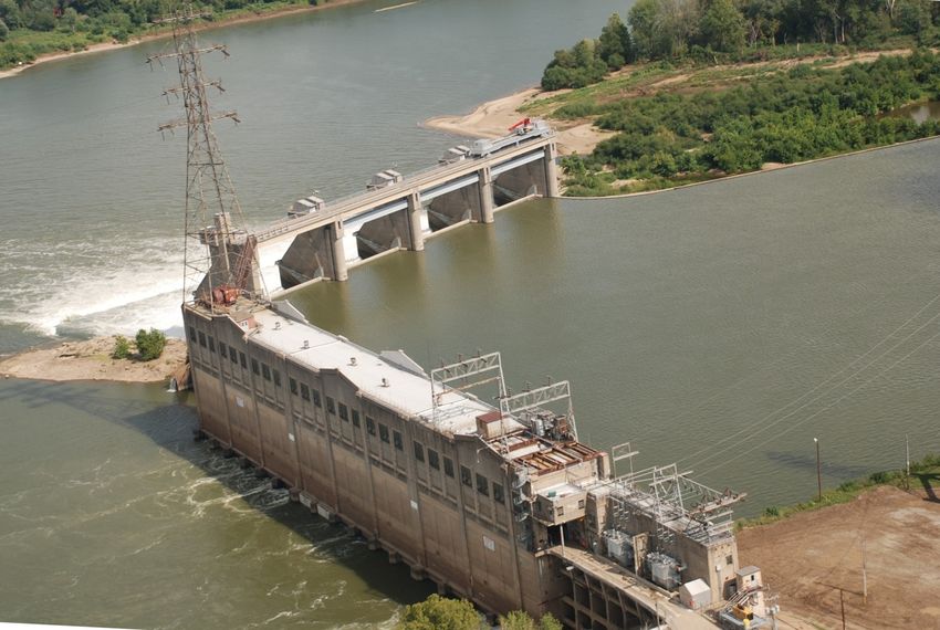
Plan for the Ohio River Basin

Table of Contents

1.0 Introduction ............................................................................................................................... 4
   1.1 Study Purpose........................................................................................................................ 4
   1.2 Ohio River Basin Overview .................................................................................................. 4
   1.3 Organizations Facilitating the Ohio River Basin Planning ................................................... 7
   1.4 Planning Assistance to States Study...................................................................................... 8
   1.5 Ohio River Basin Collaborative Planning Process .............................................................. 10
2.0 Foundational Elements............................................................................................................ 13
   2.1 Vision Statement: ................................................................................................................ 13
   2.2 Values:................................................................................................................................. 13
3.0 Goals ....................................................................................................................................... 15
4.0 Objectives and Strategies ........................................................................................................ 16
   4.1 Abundant Clean Water ........................................................................................................ 17
   4.2 Healthy and Productive Ecosystems ................................................................................... 23
   4.3 Knowledge and Education to Inform Decisions ................................................................. 26
   4.4 Nation’s Most Valuable River Transportation and Commerce Corridor ............................ 29
   4.5 Reliable Flood Control and Risk Reduction ....................................................................... 31
   4.6 World-class Nature-based Recreation Opportunities .......................................................... 35
5.0 Conclusion .............................................................................................................................. 38
6.0 References ............................................................................................................................... 39
      Appendix 1: Potential Supporting Projects by Goal.............................................................. 42
      Appendix 2: Guiding Ideals for Ohio River Basin ................................................................ 45
      Appendix 3: Key Organizations, Collaborations, and States of the Basin ............................ 46
      Appendix 4: Tribal Coordination .......................................................................................... 48

Front Cover Photo: Sunrise over the Newburgh Locks and Dam, Newburgh, Indiana. (U.S. Army Corps of
Engineers Louisville District photo by Cork McMannis)

2|Page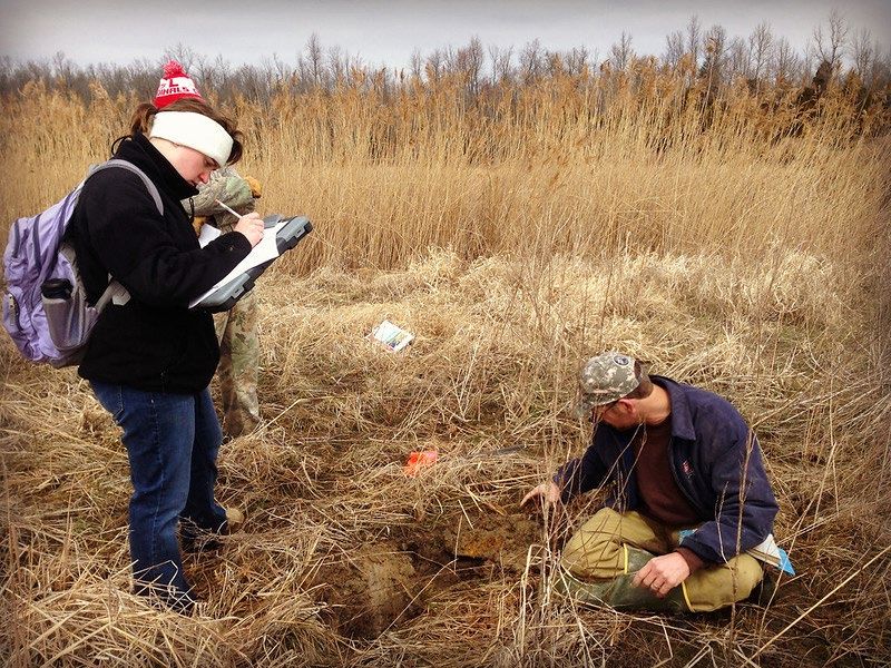
Plan for the Ohio River Basin

List of Figures

Figure 1: The Ohio River Basin. ..................................................................................................... 5
Figure 2: ORSANCO River Sweep. ............................................................................................... 6
Figure 3: USACE Focus Group in Pittsburgh, PA. ...................................................................... 10
Figure 4: Webinar Digital Notice………………………………….…………………………….11
Figure 5: Dot Voting at ORBCRE Summit……………………………………………………...11
Figure 6: Breakout Group at the ORBCRE Summit…………………………………………….12
Figure 7: A Spring Azure butterfly on a Poison Hemlock……………………………………….13
Figure 8: Public engagement at USACE……..………………………………………………….14
Figure 9: Fishing in the Ohio River Basin…………………………….. ……………….............17
Figure 10: Hydropower Station at McAlpine Locks and Dam in Louisville, KY. ……..……....18
Figure 11: The Ohio River Basin Ecoregions………………...…………………………………23
Figure 12: Blue Heron at Taylorsville Lake ……………………………………………….……24
Figure 13: USACE Conducting a Wetland Delineation……………………………………...…26
Figure 14: Cannelton Locks and Dam on the Ohio River…………..………………………..….29
Figure 15: Flood Event Map for the Ohio River Basin .......………………………………….....31
Figure 16: Lock and Dam 53 Flood Event in April 2011………….…………………………….32
Figure 17: Great Outdoor Fun Weekend Sept. 26, 2015……………………..…………...……..35
Figure 18: Kayakers in McApline Lock for the Louisville Mayor's Hike, Bike, and Paddle .......36
Figure 19: Final Construction Phase at Olmsted Lock and Dam on the Ohio River (2014). ....... 38

List of Tables

Table 1: The Study’s Original Eight Goals..................................................................................... 9
Table 2: Theme Color Code Key. ................................................................................................. 16
Table 3: Economic Benefits of Outdoor Recreation by State. ...................................................... 35

3|Page
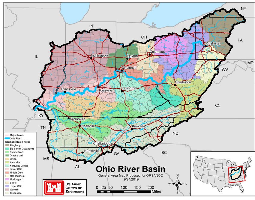
Plan for the Ohio River Basin

1.0 Introduction

1.1 Study Purpose

This report is prepared by the U.S. Army Corps of Engineers (USACE) Louisville District in
collaboration with the Ohio River Valley Water Sanitation Commission (ORSANCO) and the
Ohio River Basin Alliance (ORBA). The purpose of this study is to create an Ohio River Basin-
wide strategy, modeled after similar collaborative efforts that have achieved notable success in
many other major river basins such as the Federal Great Lakes Restoration Initiative. The study
entails a collaborative, multi-state effort to create a "blueprint" that presents goals, objectives and
actions for general improvements in economic health, ecological well-being, and quality of life
for residents throughout the Basin.

Federal agencies will not participate in strategic actions involving advocacy. Unless otherwise
noted, advocacy will be facilitated by ORBA in collaboration with existing interested non-
federal organizations and agencies

1.2 Ohio River Basin Overview

The Ohio River Basin covers 204,000 square miles encompassing parts of 15 states. It is home to
over 25 million people equaling 10% of the population of the United States. The Ohio River
alone is 981 miles long and runs from the confluence of the Allegheny and the Monongahela
Rivers in Pittsburgh, Pennsylvania and ends in Cairo, Illinois. Along the way the Ohio River
provides drinking water to several million people (Ohio River Foundation, 2020) (Figure 1).
Other systems in the Ohio River Basin include the Cumberland River which is 688 miles long,
draining about 18,000 square miles of Kentucky and Tennessee before joining the Ohio River.
The Tennessee River is 652 miles long from its confluence with the Holston River, flowing from
Virginia and North Carolina, and the French Broad River flowing from North Carolina. Other
major systems include the Kentucky, the Allegheny, the Wabash and the Miami Rivers, to name
a few. The Tennessee is the largest tributary of the Ohio River. The Ohio River and its tributaries
run through diverse landscapes including forests, agricultural, and urban lands and are home to
164 species of fish and over 100 species of mussels, including a number of threatened and
endangered species.

4|Page
Plan for the Ohio River Basin

Figure 1: The 204,000 square mile Ohio River Basin.

The waters contained in the Ohio River Basin provide a wide range of functions including
reliable and safe drinking water; transportation of goods and people; and ecosystem services
such as flood control, recreation, and supporting diverse wildlife.

The Ohio River and its seven navigable tributaries comprise over 2,500 miles of waterways,
upon which more than 270 million tons of coal, aggregates, chemicals, agricultural, industrial
and petroleum products are transported annually. This waterway transportation provides a less
costly means for companies to transport bulk goods, moving 35% of the nation's waterborne
commerce. The Ohio River is home to 38 coal-fired power plants, representing 20 percent of
nation’s coal-fired electricity generation capacity (ORSANCO). The Ohio River provides more
than half a million jobs and generates billions of dollars in business activity.

5|Page
Plan for the Ohio River Basin

                                                  The Ohio River Basin faces many challenges that
                                                  threaten the health and security of its ecosystems
                                                  and residents. For example, many of the locks
                                                  and dams that are critical to the economic success
                                                  of the water transportation system are beyond
                                                  their 50-year design life and have to be shut
                                                  down routinely for maintenance. This causes
                                                  significant traffic delays for barges navigating the
                                                  system (Inland Waterways, 2017).

                                                      According to the climate change models
                                                      performed in the Ohio River Basin- Climate
                                                      Change Pilot Study Report, a half- degree
Figure 2: ORSANCO organizes river clean ups annually. average temperature rise per decade is expected
  for 2011-2040. That number increases to one whole degree Fahrenheit per decade for 2041-2099.
  Additionally, precipitation changes are expected to impact flows. These changing precipitation
  patterns drive increased water related challenges for agriculture, river transportation, water-
  dependent industries, and communities that require reliable water.

  From 2005 to 2015, coal employment dropped by 51% in eastern Kentucky and by 39% in West
  Virginia. Societal and governmental responses to climate change may lead to continued shifts in
  the types of industry that operates in the Basin. For many people and Appalachian counties, this
  is a disorienting economic crisis. For inland waterways transportation industries, this is also a
  challenge as coal has been the backbone commodity of the Basin. An important challenge is
  developing or attracting sustainable businesses that create good jobs and utilize the river
  transportation system and port infrastructure.

  Urban runoff, agricultural activities, and abandoned mines are major causes of water pollution.
  Worse, soils and nutrients are being washed away from farmland at an order of magnitude
  greater rate than it can be replenished. Soil retention on farms is necessary for sustainable crop
  production and food security for the nation. When new industries produce new pollutants and
  emerging contaminants of concern are recognized, significant concerns should be addressed
  quickly, as the negative impacts of pollution will only become more expensive and difficult to
  remedy as time passes. Populations of wildlife are also at risk from pollution, as well as habitat
  destruction and invasive species. Habitat destruction may also increase flooding. Change in
  hydrologic regime, arising in part from loss of riparian zone and wetlands and loss of ash trees
  from the emerald ash borer, are major threats to habitat and water quality. Emerging
  contaminants of concern, impairment of recreational use due to bacteria contamination, excess
  nutrients, litter and debris and sedimentation also threaten the health and prosperity of the Ohio
  River Basin.

  Non-native invasive species are moving year by year in the Basin and threaten native species and
  the values they provide - timber, fishing, and tourism as examples among many. Invasive species
  present within the Basin include Asian carp, zebra mussels, emerald ash borer, white-nose
  syndrome fungal pathogen, purple loosestrife, kudzu, and many other plant and wildlife species.

  6|Page
Plan for the Ohio River Basin

These invasive species are capable of outcompeting native species for resources, causing disease,
altering ecosystem functions, and causing harm to the economy, environment, and human health.
The impacts of invasive species on our natural ecosystems and economy in the U.S. cost billions
of dollars each year, and many of our commercial, agricultural, and recreational activities depend
on healthy native ecosystems.

1.3 Organizations Facilitating the Ohio River Basin Planning

Ohio River Valley Water Sanitation Commission

ORSANCO was established on June 30, 1948 to control and abate water pollution in the Ohio
River Basin. ORSANCO is an interstate commission representing eight states and the federal
government. Member states include: Illinois, Indiana, Kentucky, New York, Ohio, Pennsylvania,
Virginia, and West Virginia. ORSANCO operates programs to improve water quality in the Ohio
River Basin, with a current focus on the Ohio River, including: setting waste water discharge
standards; performing biological assessments; monitoring for the chemical and physical
properties of the waterways; and conducting special surveys and studies. ORSANCO also
coordinates emergency response activities for spills or accidental discharges to the Ohio River,
and promotes public participation in programs, such as the Ohio River Sweep (Figure 2).

Ohio River Basin Alliance

The ORBA, a collaboration of Ohio River Basin stakeholders and stakeholder organizations, was
formed in 2009 to fill the need for an organization to speak for the Basin holistically by
capturing the highest priorities of the numerous organizations of the Basin and advocating for the
ecological health and economic well-being of this 'world class' basin through sound laws,
policies, and projects, and the funds to support them. ORBA is a collaboration that includes more
than 250 representatives from over 130 states, local and federal agencies, industry, academia,
and nonprofit organizations in the Ohio River Basin. ORBA’s purpose is to foster broad
collaboration to advance education and science; promote the conservation of natural resources in
the Ohio River Basin; and achieve sustainable economic growth, ecological integrity and public
safety across and within political jurisdictions within the Ohio River Basin.

ORBA Mission: To maintain a successful collaboration that will recommend strategies and
coordinate actions to address complex water resource challenges and priorities in the Ohio River
Basin with a unified voice.

ORBA Goals:

• Determine and regularly re-assess the Basin’s priorities;
• Facilitate discussions and collaborations among Basin stakeholders;
• Inform the Ohio River Basin Congressional Caucus on critical issues; and

7|Page
Plan for the Ohio River Basin

• Help facilitate the development, coordination and delivery of projects safely and in a timely
  manner.

ORBA Guiding Principles:

•   Include all Ohio River Basin stakeholders;
•   Leverage existing authorities, resources and capabilities to accomplish ORBA’s goals;
•   Capitalize on existing collaborations; and
•   Do not impede or infringe on the mission of any other organization.

U.S. Army Corps of Engineers

The mission of the US Army Corps of Engineers is to deliver vital public and military
engineering services; partnering in peace and war to strengthen our nation’s security, energize
the economy and reduce risks from disasters. There are four USACE district offices within the
study area (Huntington, Nashville, Louisville and Pittsburgh) all of whom participated in the
production of the ORSANCO Planning Assistance to States study.

The Ohio River Basin contains numerous and diverse USACE owned and operated projects. The
projects comprise both flood risk management infrastructure as well as navigation projects.
Flood risk management includes approximately 83 reservoirs and more than 100 local protection
projects (e.g. levees and floodwalls). Seventy-eight of the dams are multipurpose structures that
store and discharge quantities of water that support human activities and ecological systems. In
addition to flood risk management, these multipurpose projects provide water supply,
hydropower, low-flow augmentation that supports downstream water quality and aquatic
ecosystem purposes, recreation, fish and wildlife management and other authorized purposes.
Navigation projects along the Ohio River are incredibly important to the economy as more than
$41 billion in freight, commodities and manufactured goods transit the Ohio River system
annually.

1.4 Planning Assistance to States Study

Driven by ORSANCO, and later by the Clean Water Act and other environmental regulations,
billions of dollars have been invested by states, the federal government, and communities to
improve water quality and restore ecosystems in the Ohio River Basin. In addition to the
government initiatives, many agricultural, business, and watershed organizations have been
integral to the Basin improvement. While there has been substantial progress over the past 70
years, much work remains to address both existing and emerging challenges. Resources are
likely to be adequate to continue progress if water resources and ecosystems are a high priority.
Clear priorities for the Ohio River Basin were identified as a critical need by the U.S.
Environmental Protection Agency (U.S. EPA), USACE, and ORSANCO at their inaugural 2009
Summit. The Summit is now an annual event where Basin stakeholder groups come together to
discuss and plan improvements throughout the Basin.

8|Page
Plan for the Ohio River Basin

Since the 2009 Summit in Covington, Kentucky, one or more of the key Ohio River
organizations identified above planned and facilitated eleven collaborative summits in five Basin
states as well as coordinated webinars and focus groups that were key to developing the goals of
the PAS study:

         Columbus, OH (2010)
         Charleston, WV (2010)
         Indianapolis, IN (2011)
         Huntington, WV (2011)
         Nashville, TN (2012)
         Pittsburgh, PA (2012)
         Louisville, KY - with the America’s Watershed Initiative (2013)
         Cincinnati, OH - with the Ohio River Basin Consortium for Research and Education
             (ORBCRE) (2016)
         Huntington, WV - with ORBCRE (2017)
         Covington, KY - with ORBCRE (2018)
         Athens, OH - with ORBCRE (2019)
         Webinar Series- 5 interactive stakeholder webinars to discuss the priorities for each of the
             goals (Summer 2019)
         Pittsburgh, PA, Cincinnati, OH and Nashville, TN- Focus group series (January 2020)

This resulted in the development of the six driving goals adopted by ORBA, and the USACE
study that resulted in the report entitled: Ohio River Basin - Formulating Climate Change
Mitigation/Adaptation Strategies through Regional Collaboration.

To help build upon this extensive background of cooperation, this Planning Assistance to States
(PAS) initiative facilitated broad collaboration to develop this Ohio River Basin-wide Strategic
Plan with strategies to advance Ohio River Basin goals (Table 1). Two goals were added to the
original six to better guide conversations during the outreach effort.
 Strategic Goals
             •      Abundant Clean Water
             •      Healthy Productive Ecosystems
             •      Knowledge Informed Decisions
             •      Nation’s Most Valuable River Transportation Corridor
             •      Reliable Flood Control and Risk Reduction
             •      Timely Change Adaption and Resilience
             •      Vibrant Economy
               •    World-Class [Nature-based] Recreation Opportunities
Table 1: Eight goals were adopted at the beginning of the study. Through the planning process, Timely Change Adaption and
Resilience and Vibrant Economy were removed and combined under the other goals.

9|Page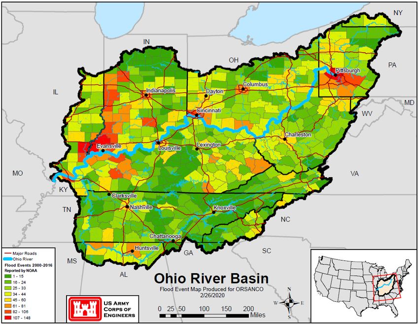
Plan for the Ohio River Basin
Key activities to establish
strategic plans for each Ohio
River Basin goal include:
• Holding a stakeholder
webinar in which an array of state
collaborations, organizations and
interested stakeholders were
invited to help identify gaps in
collaborations, stakeholders, and
strategic documents that should
be included.
• Holding four webinars, each
focused on two of the original
goals, in which experts
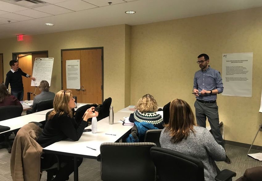
Figure 3: USACE project team members facilitate focus groups in Pittsburgh, representing stakeholders for the
PA. goal areas were invited to
participate specifically to help
ensure that there were no significant gaps in the priorities for each goal area.
• Holding eight goal-focused, facilitated discussions (described in Section 1.5) at the 2019
ORBA Summit to vet the strategies identified through the efforts to date, to seek any higher
priorities that are missing, and to evaluate the level of consensus on the strategies for each
goal.
• Following the Summit, focus groups (Figure 3) (described in Section 1.5) were convened for
any goal area that lacked a consensus set of objectives and strategic actions in order to refine
the goals so that consensus could be reached.
• Preparing and circulating a formal draft strategy among key stakeholders for comment.
1.5 Ohio River Basin Collaborative Planning Process
Stakeholder Outreach
This collaboration strives to engage all organizations in the planning process to create a strategic
plan to address the myriad of issues in the Ohio River Basin. While federal, state and local
governments have vested interest in the river, non-governmental organizations are vital to the
discussion of the needs and wishes of the people and wildlife in the Basin. Through the planning
process, USACE and ORSANCO/ORBA strived to include non-profits, universities, private
sector organizations and tribal groups that all have unique goals and priorities.
The focal point of the outreach process for this study was ORBA/ORBCRE Summit held at Ohio
State University in Athens, OH on October 2-4, 2019. This is an annual symposium for non-
profits, universities, government agencies, and other entities working within the Ohio River
Basin to come together to address regional water-related issues and stimulate solutions. The
10 | P a g ePlan for the Ohio River Basin
theme for 2019 was “Managing our Water in a Changing World: from Social, Environmental,
and Policy Perspectives”. Additionally, breakout groups were held during the conference to
enable stakeholders to provide input for this PAS study.
Leading up to the Summit, USACE and ORSANCO/ORBA
worked together to create stakeholder lists and pertinent
strategic document lists. Initial outreach efforts were
accomplished through a series of webinars. This series began
with a kick-off meeting that gave general information about
USACE and the non-federal sponsors, provided a brief
overview of the PAS study process, and began collecting
input from stakeholders. Four additional webinars were held
that focused specifically on goal areas. The webinars were
intended to begin the engagement process and reach out to
key organizations within the Basin (Figure 4).
Figure 4: Digital notices were sent out to Stakeholder engagement was approached at the Summit by
stakeholders for the five webinars. organizing eight breakout groups, each centered on one of the
preliminary strategic goals (see Table 1).
Each breakout group was assigned a facilitator and a moderator to
guide the discussion and keep activities within the given time
frame. A scribe was also assigned to ensure that all discussion was
recorded accordingly. It was explained to participants that
solutions would be reached by consensus, meaning that as long as
participants could “live with it” the solution or strategy should not
be ruled out.
Each session was an hour long and began with a brief presentation
on the study, the eight goals, and the objective of the focus goal
for that hour. The facilitator then presented the existing strategic
documents that the study team had identified and asked for
feedback from participants on other Basin-wide reports of which Figure 5: Dot voting was used at
the Summit breakout groups to
they were aware. Responses were recorded by the moderator help prioritize strategies.
(Figure 6).
11 | P a g ePlan for the Ohio River Basin
The facilitator then gave an overview of the
existing strategies that had been either
collected from the existing documentation
or gathered from input during the webinars.
The participants were asked to add
strategies they felt were missing or revise
any existing strategy they felt was not
complete or incorrect. Additionally, groups
also voted on their top priority strategic
actions with dot voting (Figure 5).
During the process of synthesizing the input
from the Summit, the number of goals was
cut from eight to six. Both the vibrant
Figure 6: After facilitated discussion for strategies under each goal,
economy and adaptive and resilience goal
participants were asked to vote on their priorities and place a red dot were incorporated either within other goals
on any “showstoppers”. or as an overarching ideal of the strategic
document.
The last outreach effort of the study consisted of a series of focus groups. During the week of
January 26, 2020, focus groups were held in Pittsburgh, Cincinnati and Nashville. The intent of
these meetings was to refine and revise the existing objectives and strategies that were
synthesized from the previous outreach activities. The focus groups consisted of small group
activities with focused discussion on objectives and strategies organized by goal. A larger group
discussion was held to focus on the Knowledge and Education to Inform Decisions goal. This
goal was the least fleshed out up to this point and warranted more holistic discussion.
Throughout the outreach process, stakeholder input was synthesized and incorporated into the
existing draft of the strategic document. A formal draft was submitted to key stakeholders for
comment at the end of February 2020. Comments were addressed and incorporated into this final
Ohio River Basin-wide Strategy.
12 | P a g ePlan for the Ohio River Basin
2.0 Foundational Elements
2.1 Vision Statement:
Through collaboration with a diverse mix of organizations working in the Ohio River Basin, we
envision a basin that is a healthy, clean, and productive system that sustains ecosystems and
provides valuable services for all, now and in the future.
2.2 Values:
Through the planning process, several themes arose that crossed the boundaries between goals to
provide guidance by setting the overarching values of this plan. While these did not contribute
directly to the objectives and strategies presented, they are underlying principles that the
stakeholders hope permeate throughout the plan.
• Comprehensive, Connected System There is a need to consider the Ohio River Basin as
a connected system; solutions should be approached from this perspective in order to
impact the Basin as a whole. In the same measure, it is imperative that input be gathered
from a wide array of stakeholders, including both governmental and non-governmental
organizations. Having a comprehensive approach that recognizes the interconnectedness
of the river system as well as the entities working within the Basin will provide solutions
that address the complexity of the system and the correlated impacts of those working to
improve it.
• Long Term Considerations This plan
strives to incorporate long term strategic
actions that ensure that climate change,
resiliency and sustainability are all prioritized
and influence the preferred strategies. The plan
will incorporate identification and preparation
for slow-developing or non-linear threats, such
as droughts, increased flooding, human
population impacts, disruptive technologies,
earthquakes, and infrastructure disturbances
into all goals. This plan acknowledges that
Figure 7: Healthy aquatic and riparian ecosystems must be
climate changes needs to be addressed locally,
sustained throughout the Basin. Here, a Spring Azure butterfly regionally, nationally and globally to prevent
shares a Poison Hemlock flower with a beetle and bee. the impacts from warming temperatures.
Inaction will only exacerbate efforts to restore
and protect the Ohio River Basin (Figure 7).
• Nature-Based Considerations Prioritize and incentivize nature-based solutions in order
to take an innovative, environmentally sensitive approach to problem solving. These
solutions include the consideration of positive ecosystem restoration opportunities in
transportation infrastructure and flood risk management projects.
13 | P a g ePlan for the Ohio River Basin
• Research and Education Ensure that research and education accelerates improvement in
the Ohio River Basin, including the promotion of further academic studies of climate
change to reduce uncertainty of future conditions. Ensure that the education program,
focused on K-16 and community organizations, furthers a wider base of support and
understanding of the ecological and environmental issues facing the Ohio River Basin.
• Consideration of Vulnerable Populations Prioritize the needs and vulnerabilities of at-
risk, low-income or underserved communities given the history of ecological and social
injustice. Ensure that all strategic actions are just and equitable with a focus on flood risk
management measures that target areas most in need, address issues of environmental
justice, and recognize the importance of tribal communities’ contributions to our culture
and history. Giving representation to vulnerable populations when decisions are being
made can help support restoration priorities, policy solutions, and investment decisions
that lead to equitable and just outcomes so that all of the people in the region benefit from
the implementation of the regional strategy.
• Active Public Engagement Elevate pride of place in the Ohio River Basin by engaging
the public broadly with the benefits of the streams and rivers of the Basin and the services
they provide. Provide easy access to the recreational infrastructure that gets people on
and by the streams and rivers. Encourage the public to participate in citizen science
initiatives. Utilize social media and other communications to connect with and educate
citizens (Figure 8).
Figure 8: Public engagement at USACE
lake.
14 | P a g ePlan for the Ohio River Basin 3.0 Goals The goals provide for long term end products of the plan based on the different areas of concern throughout the Basin. The study team, including USACE, ORBA, ORSANCO and other stakeholders, agreed on these goals during the planning process to provide comprehensive strategies and solutions for the Ohio River Basin. The goals are qualitative and are meant to guide the objectives as well as guide the function of working groups aligned with the goals. Abundant Clean Water: Ensure the quality and quantity of water in the Ohio River Basin is adequate to support the economic, social, and environmental functions that are dependent on it. Healthy and Productive Ecosystems: Conserve, enhance, and restore ecosystems within the Ohio River Basin to support natural habitats and the fish and wildlife resources that depend upon them. Knowledge and Education to Inform Decisions: Ensure that research and education adequately inform Ohio River Basin-wide economic, social, and environmental decisions; enhance the profile of education organizations in the Basin that synergize efforts to garner effective public involvement in the stewardship and management of the Basin’s resources. Nation’s Most Valuable River Transportation and Commerce Corridor: Provide for safe, efficient, and dependable commercial navigation within the Ohio River Basin to ensure a competitive advantage for our goods in global and regional markets; sustain a water use system to efficiently and effectively support agricultural, industrial, and energy productivity. Reliable Flood Risk Management: Provide reliable flood risk management through well- managed and maintained infrastructure, including appropriate floodplain connections for water conveyance and ecosystem benefits, and management of surface and storm water runoff to better protect life, property, and economies. World-class Nature-based Recreation Opportunities: Enrich the quality of life for people and recreation-based economies by maintaining and enhancing riverine, lake, and wetland-associated recreation within the Basin. 15 | P a g e
Plan for the Ohio River Basin

4.0 Objectives and Strategies

The objectives below are meant to meet each goal and are quantitative in nature. The strategies
under each objective are meant to be tangible steps that can be taken to meet the given objective.
Each strategy is color coded based on theme as shown in Table 2 below.

 Funding
 Partnerships/Collaboration
 Advocacy Targets
 Data Collection/ Monitoring
 Analysis/Reporting/Outreach
Table 2: Each strategy is color coded by theme.

16 | P a g e
Plan for the Ohio River Basin

4.1 Abundant Clean Water

The Ohio River Basin’s abundant
supply of clean, fresh water is vital to
the regional economy and the health of
its natural and human communities
(Figure 9). Recognizing this, federal
and state laws have been designed to
ensure that water quality is sufficient to
allow for a safe and sustainable public
water supply, water-dependent
economic activities, agriculture,
healthy fish and wildlife populations,
and water-related tourism and
recreation. Additionally, water quality
is increasingly linked to water quantity,
as governments address the threat of
water shortages due to the extremes in
flooding and drought events anticipated
with future climate changed in the
Basin (Drum et al, 2017).
Basin states and the U.S. EPA, in
collaboration with ORSANCO,
Cumberland River Compact,                  Figure 9: Safe fishing in the waters of the Ohio River Basin requires
Tennessee Valley Authority (TVA),          clean water.
conservation organizations and federal
agencies have made significant progress, yet work remains to improve water quality to levels
that support sustainable use while maximizing benefits. Challenges such as non-point source
pollution, legacy and emerging contaminants, and uncertainty associated with climate change
remain. Non-point source pollution, exacerbated by impervious surfaces and flashy streams,
conveys soil and associated contaminants into the Basin’s waters on a routine basis. Beneficial
uses and engineered activities can have short- and long-term side effects that can degrade water
quality by suspending sediments and contaminants into the water column for downstream
transport, negatively impacting aquatic habitat and biological communities. Monitoring is a
critical action to inform decision making. There is a need to continue support for or expand
coordination of monitoring for core physical, chemical and biological indicators throughout the
Basin. Harmful Algal Blooms (HABs) are a routine and documented item of concern in
waterbodies across the Basin including USACE reservoirs because of the cyanotoxins they
produce and the harm they can cause to aquatic ecosystems (e.g. dissolved oxygen depletion). Of
late, two unprecedented bloom events have occurred in the Ohio River (2015, 2019), causing
serious health risks and economic impacts throughout the Basin. In response, ORSANCO
organized communication and monitoring activities, utilizing its HAB monitoring and response
plan that included state, federal, and local agencies and utilities. These efforts proved to be
critical in obtaining the data necessary to properly advise the public of HAB risk.

17 | P a g e
Plan for the Ohio River Basin

Hydropower dams on the Ohio River and its tributaries can also provide water quantity and
quality data in addition to producing clean energy for Ohio River Basin residents. Currently there
are over 130 hydroelectric facilities on dams within the Basin. As part of requirements of
Federal Energy Regulatory Commission (FERC) licensing agreements, hydropower facilities
collect water quality data, enhancing real-time and discrete datasets available to the USACE and
other stakeholders. Additionally, hydropower activities improve local economies by providing
jobs for local residents. The McAlpine Locks and Dam in Louisville, KY is one example of a
hydropower dam on the Ohio River (Figure 10).

Figure 10: The hydropower station at McAlpine Locks and Dam in Louisville, KY.

While episodes of drought and flooding have occurred historically throughout the Ohio River
Basin, these events have been isolated and infrequent. Climate change has the potential to
increase the frequency and magnitude of extreme weather events, so testing the existing
operating schemes and infrastructure will be important. Recognition of this may be driving a
recent interest in obtaining water quality and water quantity data, resulting in a net increase in
U.S. Geological Survey (USGS) gage sites throughout the Basin over approximately the past 10
years, with particular growth in Indiana and Ohio (J. Woods, personal communication, August 6,
2020). Improvements in water quantity modeling of the Ohio River, especially during low flow
conditions, could provide significant benefits.
While many challenges to water quality and quantity exist such as bacteria impairments to
recreational uses, legacy pollutant and other impairments - sufficient expertise in private, public
and academic sectors are available to address needs, conduct research and answer questions that

18 | P a g e
Plan for the Ohio River Basin

arise. Additionally, strong and longstanding partnerships exist in the Basin between state
agencies, ORSANCO, U.S. EPA, USGS, USACE, TVA, other government agencies,
universities, utilities, non-profits and other stakeholders. This provides a strong foundation and
leverage for new efforts.

   Objective 1: Organizations and states, enabled by the Clean Water Act will work
   collaboratively to demonstrate an increased number of water bodies that meet the Clean
   Water Act’s drinkable, swimmable, and fishable uses by 2030 as compared to 2020.
   Strategic Actions (See Table 2 for color key):
    • Secure financial and other necessary resources through an Ohio River Basin
      Restoration Initiative and other appropriate funding mechanisms to support all Strategic
      Actions under this Objective (See Appendix 1). Examples of projects include: Water
      Control Manual Updates, Watershed Management Plans, and Environmental
      Infrastructure Projects.
    • Develop and maintain a comprehensive Ohio River Basin geographic information
      system (GIS) platform to support Clean Water Act related initiatives such as water
      quality monitoring and assessment, location of critical assets, water quality standards
      attainment and other related initiatives.
    • Support the actions of state, federal, interstate and other Ohio River Basin
      organizations to implement Clean Water Act designated use requirements through
      improved water quality standards attainment; Basin state water quality protection
      efforts; the Ohio River Valley Water Sanitation Compact; and Ohio River Basin
      watershed organizations’ missions to improve water quality for water bodies within the
      Ohio River Basin leading to improved use attainment.
    • Support state, federal, interstate and other strategic organizations’ efforts to monitor
      and assess the presence and health risks of Contaminants of Emerging Concern, such as
      per- and polyfluoroalkyl substances (PFAS), mercury, microplastics, 1,4-dioxane and
      plasticizers.
    • Stabilize and expand the installation and maintenance of USGS super gages for Ohio
      River Basin rivers, streams and critical watersheds to enable the ability to perform
      change analysis and support Clean Water Act related flow and water quality
      monitoring.
    • Support the development of a Basin-wide GIS inventory of acid mine/rock drainage
      sites, coal ash ponds, and underground mine pools associated with active and inactive
      coal mines prioritized based upon risk of failure, and develop a reclamation strategy to
      address 10 inventoried, high priority locations.

19 | P a g e
Plan for the Ohio River Basin
Objective 2: By 2025, develop effective strategies which can support and enhance the
individual utility source water protection programs to meet Safe Drinking Water Act
requirements as they are developed and use best practices from these strategies to build
collaborative programs to help support Ohio River Basin drinking, industrial, surface and
ground water organizations that do not currently have source water protection programs.
Strategic Actions:
• Secure financial and other necessary resources through an Ohio River Basin
Restoration Initiative and other appropriate funding mechanisms to support all Strategic
Actions under this Objective.
• Develop and maintain data layers for inclusion in the comprehensive Ohio River Basin
GIS platform to support source water protection related initiatives such as mapping
source water protection areas, contaminant source inventories, contaminant spill
locations, source water protection risk zones and other related initiatives.
• Maintain and expand ORSANCO’s Ohio River Organics Detection System to help
detect and respond to volatile and other organic compound spills and detectible
emerging contaminants of concern both reported and unreported that may impact the
Ohio River and its tributaries as a drinking and industrial water supply.
• Utilize ORSANCO’s source water protection program template as well as other
identified Basin source water protection templates to build collaborative source water
protection strategies for all water bodies within the Basin that serve as a drinking or
industrial water supply.
• Identify and expand existing source water protection collaborations within the Ohio
River Basin to help ensure the protection of water supplies to drinking and industrial
water customers.
Objective 3: By 2025, identify priority waters with high incidences of HABs and convene
stakeholders to prepare an Ohio River Basin-wide strategy to help respond to HABs and
that will result in measurable reduction in HAB occurrence by 2030 as compared to 2020
for priority areas.
Strategic Actions:
• Secure financial and other necessary resources through an Ohio River Basin
Restoration Initiative, and other appropriate funding mechanisms to support all
Strategic Actions under this Objective.
• Develop and maintain data layers for inclusion in the comprehensive Ohio River Basin
GIS platform to map water bodies that have HAB occurrence to support the Basin-wide
effort to achieve measurable reduction in HAB occurrences.
• Support HAB monitoring and response strategies of state, federal, interstate and other
Ohio River Basin organizations to maintain safe recreation and drinking water for Ohio
River Basin citizens.
20 | P a g ePlan for the Ohio River Basin
• Identify and inventory point and non-point nutrient sources, communicate and
implement nutrient reduction best management practice strategies to support reductions
in nutrient contributions for identified sources to Ohio River Basin water bodies.
• Support the December 2016 Federal Hypoxia Task Force Strategy as it relates to
nutrient contributions from the Ohio River Basin, including advocacy * for the Federal
Hypoxia Task force to summarize literature and identify additional measurement and
modeling needs on the general location and significance of nutrient sources in the Ohio
River Basin, including both point and nonpoint sources contributing nutrients to
particular tributaries and/or mainstem segments.
• Support existing market-based solutions (e.g., Electric Power Research Institute’s Ohio
River Basin Water Quality Trading Project, etc.) working across stakeholder groups to
reduce nutrient loading to waterbodies from point sources and non-point sources.
Objective 4: By 2025, The Ohio River Valley Water Sanitation Commission(ORSANCO)
will convene water quantity managers Basin-wide such as USGS and Division of Water
(DOW) to establish common goals directed at identifying Basin-wide problems affecting
water quantity management and recommend strategies to address these goals.
Strategic Actions:
• Secure financial and other necessary resources through an Ohio River Basin
Restoration Initiative and other appropriate funding mechanisms to support all Strategic
Actions under this Objective.
• Develop and maintain data layers for inclusion in the comprehensive Ohio River Basin
GIS platform to support water quantity related initiatives such as mapping flood risk
areas, drought mitigation planning areas, water supply deficit/surplus areas and related
initiatives.
• Develop partnerships to leverage available funding streams to maintain and expand
USGS Stream Gage network to be able to accurately measure flow in Ohio River Basin
streams. Utilize this data to improve hydrologic and hydraulic models so as to test
existing infrastructure resiliency as it pertains to expected climate changes.
• Build upon ORSANCO’s water quantity initiatives developed through its Water
Quantity Committee to convene Ohio River Basin Water Quantity Stakeholders to
conduct discussions and long-term planning to develop strategies to address water
shortages and other relevant challenges within the Basin related to climate change,
population growth and other stressors.
• Collaborate with domestic and international water quantity-related commissions to
share information, exchange strategies, incentivize conservation, and advance common
*
Federal agencies will not participate in strategic actions involving advocacy. Unless otherwise noted, advocacy
will be facilitated by ORBA in collaboration with existing interested non-federal organizations and agencies
21 | P a g ePlan for the Ohio River Basin
goals directed at solving problems affecting water quantity and leveraging these
strategies and goals as vital Ohio River Basin assets.
• Facilitate collaboration to pursue a focused water quantity study to follow on to the
existing USACE study that specifically addresses climate change as it relates to water
quantity impacts in the medium and long term (by 2040 and 2100, respectively).
Objective 5: By 2025, inventory drinking and wastewater system infrastructure needs
for the Ohio River Basin and develop a strategy to maintain these systems Basin wide.
Strategic Actions:
• Increase financial and other necessary resources through the Water Infrastructure
Financing and Innovation Act (WIFIA), State Revolving Loan Fund (SRF), and other
appropriate infrastructure funding mechanisms to maintain aging drinking and
wastewater infrastructure systems.
• Develop and maintain data layers for inclusion in the comprehensive Ohio River Basin
GIS platform to inventory drinking and wastewater system infrastructure needs for the
Ohio River Basin.
• Leverage the USEPA Water and Wastewater Infrastructure Needs Assessment Survey
to develop a communication strategy for the need to address these aging infrastructure
assets on an Ohio River Basin-wide basis that details the urgency associated with
increased infrastructure failures.
22 | P a g ePlan for the Ohio River Basin
4.2 Healthy and Productive Ecosystems
Challenges and Opportunities:
The Ohio River Basin drains an area of approximately 200,000 square miles with 7,000 miles of
waterfront along the Ohio River and its major tributaries. The Ohio River Basin is nationally and
internationally renowned for its array of ecoregions with a diversity of flora and fauna that
distinguishes it from other basins within the nation (Figure 11). Portions of at least 16 distinct
Level III ecoregions can be identified within the Basin. A great number of aquatic species inhabit
the waters of the Basin making it one of the most diverse and productive regions in the nation
(Figure 12). As part of the larger Ohio River Basin watershed, the Green, Tennessee, and
Cumberland River sub-basins are three of the richest ecological regions in the nation and are
among the richest in terms of species diversity in the world. However, extensive human activity
has led to the loss or modification of wildlife habitat that negatively impacts key ecosystem
functions and imperils native wildlife populations. For example, of the 127 species of mussels
once found in the Ohio River, 11 are extinct, and 46 others are classified as threatened,
endangered, or a species of concern. There are an additional 625 species from other taxa within
the 15 Basin states that are federally listed as threatened or endangered (USACE Comprehensive
Reconnaissance Report, 2009).
Figure 11: The Ohio River Basin has a diverse array of ecoregions.
Invasive species such as Asian carp (i.e., bighead, silver, black, and grass carp), round goby,
curly leaf pondweed, hydrilla, and zebra mussels, have been documented in the Ohio River Basin
(Ohio State University, 2018) and have potential to cause lasting environmental and economic
23 | P a g ePlan for the Ohio River Basin
damage. Whether introduced accidentally or intentionally, invasive species often grow faster,
mature earlier, disperse readily, and have few natural predators. When established, they can
threaten ecological stability, outcompete native species, reduce biodiversity, degrade water
quality, or otherwise negatively affect commercial, agricultural, or recreational activities.
Soil health has a profound impact on ecosystems as well as water quality and overall Basin
stability. Improving soil health is the most effective way to decrease run off by improving water
infiltration into the soil further improving moisture and nutrient retention for healthy crop growth
(NRCS, 2020).
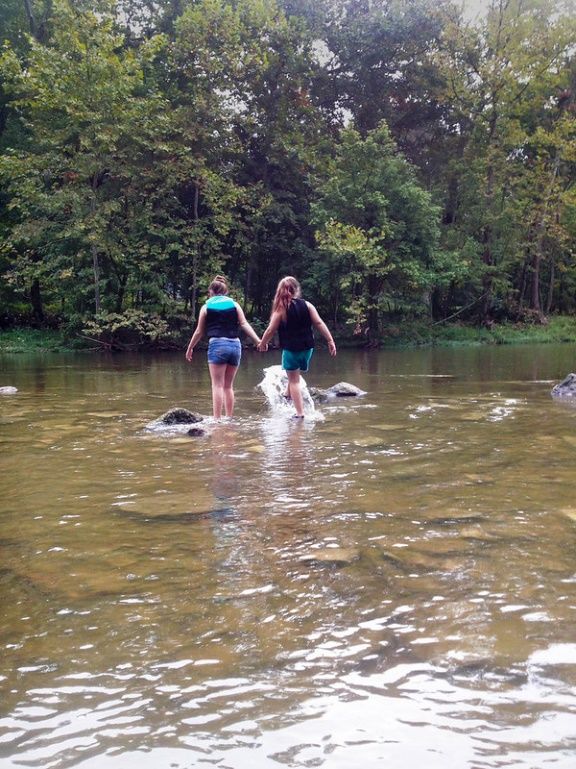
Figure 12: A blue heron takes flight at Taylorsville Lake,
one of many USACE managed lakes within the Basin.
Objective 1: By 2022, Basin states and the U.S. EPA, ORSANCO, conservation
organizations, federal agencies, and other stakeholders will develop a plan for Ohio River
Basin restoration through the identification and protection of at-risk ecosystems and the
threats to them such as acid mine drainage or emerging toxic contamination. Examples of
at-risk ecosystems include wetlands and riparian zones, habitat for threatened or
endangered species, and other areas of ecological significance.
Strategic Actions:
• Facilitate collaboration and resource coordination among the Ohio River Basin Fish
Habitat Partnership, the Southeast Aquatic Resources Partnership, The Nature
Conservancy, the National Wildlife Federation, and other stakeholders to further
cooperative development of strategic aquatic restoration and protection opportunities.
(See Appendix 1). Examples of projects include aquatic ecosystem restoration.
• In coordination with U.S. EPA, states, and local organizations, encourage and advocate
for funding for regional programs that restore, protect and manage valuable habitat and
water resources through implementation of the Ohio River Basin Fish Habitat
Partnership strategy (USACE 2009; USFW Landscape Priorities; ORBFHP 2013) (See
Appendix 1). Examples of projects include aquatic ecosystem restoration.
Objective 2: By 2025, secure funding to initiate a federal geographic program for the
restoration of the Ohio River Basin that is appropriate to the need identified by the states,
24 | P a g ePlan for the Ohio River Basin federal agencies including the U.S. EPA, ORSANCO, conservation organizations, and other stakeholders. Strategic Actions: • Taking guidance from similar federally-funded geographic restoration initiatives (i.e., the Great Lakes Restoration Initiative, Chesapeake Bay Program, and Columbia River Restoration Program), establish a novel Basin restoration initiative through efforts that seek to find and gather support for a legislative champion(s), develop formal governance procedures, define formal restoration goals and milestones, and establish advisory committees and advocacy groups that, together with public outreach efforts, build a diverse coalition that works to protect and restore the Ohio River Basin. • In collaboration with the states and interested water resource groups, pursue investment in a robust restoration economy that restores floodplains and connectivity, protects existing high quality habitat, restores and protects native aquatic populations, strategically leverages water resources to strengthen local economies, and positions the Ohio River Basin as an attractive site to draw and retain workforce (USFW Landscape Priorities; ORBFHP 2013; USACE/ORBA 2017). • Facilitate Basin-wide collaboration that expands upon the NRCS’s existing Mississippi River Basin Healthy Watersheds Initiative, among agricultural organizations and agencies to define and pursue a large-scale, healthy soil initiative to protect farmlands and improve water quality, water retention, erosion control, and fish and wildlife habitat. Objective 3: In collaboration with state and federal agencies and other stakeholders, develop and implement strategies to eradicate, control, and manage invasive species within the Ohio River Basin. Management and control strategies should be comprehensive in application and proactive in nature by utilizing sound scientific data designed to analyze and assess risk, develop and utilize effective control methods, limit dispersal, reduce the effects of invasive species, and focus conservation efforts on high-priority ecosystems within the Basin. Management and control efforts should also include the public sector via the development and implementation of education and outreach programs designed to increase the understanding of the potential ecological, economic, and social impacts of invasive species within the Basin. Strategic Actions: • Advocate for existing entities, i.e., Aquatic Nuisance Species (ANS) Task Force, to develop and implement a Basin-specific program designed to coordinate efforts to monitor, control, and study invasive species. • Advocate for full funding of Asian Carp National Plan with full funding for Ohio River Basin by 2021 (inclusive of the Tennessee and Cumberland Rivers)(USACE 2009; MICRA, 2018) 25 | P a g e
Plan for the Ohio River Basin

4.3 Knowledge and Education to Inform Decisions

Challenges and Opportunities:
Technical problems are those for which
optimal solutions can be pursued.
Selection of efficient and effective
solutions depends on the quality and
availability of knowledge at the time the
decision is made. Performing and
reporting on research related to priorities
of the Basin and providing effective
formal and informal education for the
public and for decision-makers will
provide timely, state-of-the-art
knowledge to inform decisions.

Research is needed to inform technical          Figure 13: USACE Louisville District representatives conduct a
problems in each of the other goals of        wetland delineation at the Kentucky Army National Guard Wendell H.
                                                        Ford Regional Training Center, Greenville, Ky.
this strategy (Figure 13). Examples of
needed research and education include:

    •   For informing river navigation decisions - the economic value of water uses in the Basin,
        and the dams and reservoirs that ensure the adequacy of the water;
    •   For ecosystem restoration and protection decisions - the impacts of hydromodification
        leading to erosion, flooding and habitat loss and identification of effective and efficient
        means of preventing and reversing impacts of invasive species;
    •   For abundant clean water - efficient and effective means of preventing loss of
        irreplaceable soils and excess nutrients from impacting waterbodies through runoff;
    •   For nature-based recreation – application of methods of assessing the benefits and costs
        of river recreation to the local economy as well as the benefits and costs of low head dam
        removal;
    •   And for flood risk reduction - modeling of the flood protection projects and reservoirs of
        the Basin as a system to understand interactive impacts on flooding.

Collaboration among organizations involved with relevant research and partnerships with
decision makers addressing Basin-wide priorities is needed to ensure that research and education
receives focus and funding necessary to solve technical challenges and inform decisions. The
sharing of research and data is also vital to prevent the duplication of efforts, resulting in
efficient and thorough data collection.

Public education plays a major role in the success of the Basin. Conveying the unique history
and attributes of the Basin to the public at large, particularly children, increases pride and fosters
stewardship of natural lands. While this is a powerful tool to improve the Basin, it can also be
taken a step farther to include the public in research. Volunteer surveys and citizen science such
as bird counts provide valuable data and encourage the public to invest in their natural
surroundings.

26 | P a g e
You can also read


