SUSTAINABLE MANAGEMENT OF THE SALALAH COASTAL AQUIFER IN OMAN USING AN INTEGRATED APPROACH - MAHAAD ISSA SHAMMAS MAY 2007 - DIVA PORTAL
←
→
Page content transcription
If your browser does not render page correctly, please read the page content below
SUSTAINABLE MANAGEMENT OF THE
        SALALAH COASTAL AQUIFER IN OMAN
          USING AN INTEGRATED APPROACH

                  Mahaad Issa Shammas

                            May 2007

TRITA-LWR PhD Thesis 1031
ISSN 1650-8602
ISRN KTH/LWR/PHD 1031-SE
ISBN 978-91-7178-645-6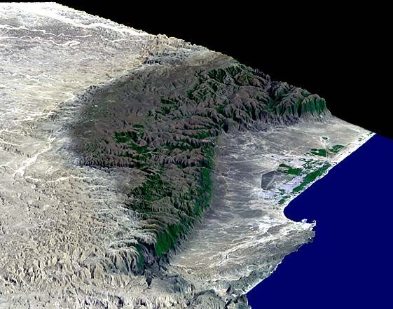
Sustainable management of the Salalah coastal aquifer in Oman using and integrated approach

 Cover Illustration:
 Satellite image of Salalah plain and adjacent Jabal Al-Qara (source,
 National Meteorological Service/Sultanate of Oman, 2004).

© Mahaad Issa Shammas 2007

Doctoral Thesis
Department of Land and Water Resources Engineering
Royal Institute of Technology (KTH)
SE-100 44 STOCKHOLM, Sweden

TRITA-LWR PhD Thesis 1031
ISSN 1650-8602
ISRN KTH/LWR/PHD 1031-SE

ISBN 978-91-7178-645-6
Universitetsservice US AB, Stockholm, 2007

                                                          ii
Mahaad Shammas                                                     TRITA LWR PhD Thesis 1031

                 I dedicate this work to my elder brother Ali, with love

                                           iii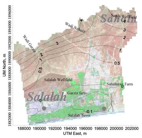
Sustainable management of the Salalah coastal aquifer in Oman using and integrated approach

                                            iv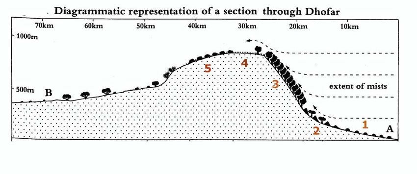
Mahaad Shammas TRITA LWR PhD Thesis 1031
ﺑﺴﻢ اﷲ اﻟﺮﺣﻤﻦ اﻟﺮﺣﻴﻢ
اﻹدارة اﻟﻤﺴﺘﺪاﻣﺔ ﻟﺤﻮض ﺳﻬﻞ ﺻﻼﻟﺔ اﻟﺠﻮﻓﻲ اﻟﺴﺎﺣﻠﻲ ﺑﺎﺳﺘﺨﺪام ﻧﻤﻮذج ﻣﺘﻜﺎﻣﻞ
)ﻣﻠﺨﺺ(
ﻻ
ﺗﻜﻮن ﺣﻮض ﺳﻬﻞ ﺻﻼﻟﺔ اﻟﺠﻮﻓﻲ اﻟﺴﺎﺣﻠﻲ اﻟﻀﺤﻞ ﻓﻲ ﻃﺒﻘﺎت ﻣﻦ اﻟﺤﺠﺮ اﻟﺠﻴﺮي اﻟﺜﻼﺛﻲ ،ﻳﻤﺘﺪ ﺷﻤﺎ ً
إﻟﻰ أﻗﺪام ﺟﺒﺎل اﻟﻘﺮا وﺟﻨﻮﺑًﺎ إﻟﻰ ﺷﺎﻃﺊ اﻟﺤﺎﻓﺔ .ﺗﻌﻠﻮ ﻃﺒﻘﺔ اﻟﺤﺠﺮ اﻟﺠﻴﺮي ﻃﺒﻘﺔ ﻣﻦ رﺳﻮﺑﻴﺎت اﻟﻌﺼﺮ
اﻟﺮﺑﺎﻋﻲ ،ﺗﺘﻜﻮن ﻣﻦ رﺳﻮﺑﻴﺎت اﻷودﻳﺔ اﻟﻐﺮﻳﻨﻴﺔ واﻟﺮﺳﻮﺑﻴﺎت اﻟﺠﻴﺮﻳﺔ اﻟﺴﺎﺣﻠﻴﺔ .ﺗﻄﻮرت ﻋﺪﺳﺔ ﻋﺬﺑﺔ ﻣﻦ
اﻟﻤﻴﺎﻩ اﻟﺠﻮﻓﻴﺔ ﻓﻲ وﺳﻂ اﻟﺴﻬﻞ ﻣﻊ وﺟﻮد ﻣﻴﺎﻩ ﺟﻮﻓﻴﺔ ﺷﺒﺔ ﻣﺎﻟﺤﺔ إﻟﻰ اﻟﺸﺮق واﻟﻐﺮب ﻣﻦ اﻟﺴﻬﻞ ﺑﻴﻨﻤﺎ
ﺗﺤﺪث ﻋﻤﻠﻴﺔ ﺗﺪاﺧﻞ ﻟﻤﻴﺎﻩ اﻟﺒﺤﺮ ﻣﻦ ﺟﻬﺔ اﻟﺠﻨﻮب.
ﺗﻢ دراﺳﺔ اﻹدارة اﻟﻤﺴﺘﺪاﻣﺔ ﻟﻠﻤﻴﺎﻩ اﻟﺠﻮﻓﻴﺔ ﻓﻲ ﺣﻮض ﺻﻼﻟﺔ اﻟﺠﻮﻓﻲ ﺑﻬﺪف اﻻﺳﺘﻐﻼل اﻷﻣﺜﻞ ﻟﻠﻤﻮرد
اﻟﻤﺎﺋﻲ واﻟﻤﺤﺎﻓﻈﺔ ﻋﻠﻴﻪ ﻣﻦ اﻻﺳﺘﻨﺰاف واﻟﻬﺪر واﻟﺘﺼﺪي ﻻﻧﺨﻔﺎض ﻣﺴﺘﻮﻳﺎت اﻟﻤﻴﺎﻩ اﻟﺠﻮﻓﻴﺔ وﺗﺪاﺧﻞ ﻣﻴﺎﻩ
اﻟﺒﺤﺮ اﻟﻤﺎﻟﺤﺔ ﻓﻲ اﻟﺤﻮض .ﻳﻌﺘﺒﺮ ﻣﻜﻤﻦ ﺳﻬﻞ ﺻﻼﻟﺔ اﻟﻤﺎﺋﻲ اﻟﻤﺼﺪر اﻟﻮﺣﻴﺪ ﻟﻠﻤﻴﺎﻩ اﻟﻌﺬﺑﺔ ﻟﺘﻠﺒﻴﺔ اﻟﻄﻠﺐ
اﻟﻤﺘﺰاﻳﺪ ﻋﻠﻰ اﻟﻤﻴﺎﻩ ﻓﻲ ﻣﺪﻳﻨﺔ ﺻﻼﻟﺔ .ﻳﺘﻢ ﺿﺦ اﻟﻤﻴﺎﻩ ﻣﻦ اﻟﺤﻮض اﻟﺠﻮﻓﻲ ﻋﺒﺮ أآﺜﺮ ﻣﻦ ) (1500ﺑﺌﺮ
إﻧﺘﺎﺟﻴﺔ ﺣﻴﺚ ﻳﻘﺪر ﻣﺠﻤﻮع اﻟﺴﺤﺐ اﻟﺤﺎﻟﻲ )2005م( ﻟﻠﻤﻴﺎﻩ اﻟﺠﻮﻓﻴﺔ ﻟﻼﺳﺘﺨﺪاﻣﺎت اﻟﻤﺨﺘﻠﻔﺔ ﺑﺤﻮاﻟﻲ )(65
ﻣﻠﻴﻮن ﻣﺘﺮ ﻣﻜﻌﺐ وﻣﻦ اﻟﻤﺘﻮﻗﻊ أن ﻳﺰداد اﻟﺴﺤﺐ ﺳﻨﻮﻳًﺎ ﺑﻤﻌﺪل ﻣﺘﻨﺎﻣﻲ ﺑﻮاﻗﻊ %3ﺳﻨﻮﻳًﺎ ﻟﻴﺼﻞ إﻟﻰ 74
ﻣﻠﻴﻮن ﻋﺎم 2020م .وﻋﻠﻴﻪ ﻓﻤﻦ اﻟﻤﺘﻮﻗﻊ أن ﻳﺘﺮاوح اﻟﻌﺠﺰ ﻓﻲ اﻟﻤﻴﺰاﻧﻴﺔ اﻟﻤﺎﺋﻴﺔ ﻟﻠﺤﻮض اﻟﺠﻮﻓﻲ ﺑﻴﻦ )9
إﻟﻰ 13ﻣﻠﻴﻮن ﻣﺘﺮ ﻣﻜﻌﺐ ﺳﻨﻮﻳًﺎ( ﺑﻴﻦ اﻟﻌﺎﻣﻴﻦ 2005إﻟﻰ 2020م ،ﺣﻴﺚ ﻳﻔﻮق اﻹﻧﺘﺎج اﻟﻜﻠﻲ ﻣﻦ اﻟﺤﻮض
اﻟﺘﻐﺬﻳﺔ اﻟﻄﺒﻴﻌﻴﺔ واﻟﺼﻨﺎﻋﻴﺔ ﺑﻨﺴﺒﺔ ﺑﻴﻦ ) %16إﻟﻰ (%21أﻋﻠﻰ ﻣﻦ اﻹﻧﺘﺎج اﻵﻣﻦ ﺑﻴﻦ اﻟﻌﺎﻣﻴﻦ 2005إﻟﻰ
2020م .اﻟﻤﻌﺪل اﻟﺤﺎﻟﻲ ﻟﻠﻀﺦ ﻏﻴﺮ ﻣﺴﺘﺪام وﺗﺪهﻮر ﺟﻮدة اﻟﻤﻴﺎﻩ اﻟﺠﻮﻓﻴﺔ واﺿﺤﺔ ﻓﻲ أﺟﺰاء آﺜﻴﺮة ﻣﻦ
ﺳﻬﻞ ﺻﻼﻟﺔ.
وﻗﺪ ﺗﻀﻤﻨﺖ اﻟﺪراﺳﺔ ﺑﻨﺎء ﻧﻤﻮذج رﻗﻤﻲ ﺛﻼﺛﻲ اﻷﺑﻌﺎد ﻟﺘﺪﻓﻖ وﺣﺮآﺔ اﻷﻣﻼح ﻓﻲ اﻟﻤﻴﺎﻩ اﻟﺠﻮﻓﻴﺔ ﻟﻤﺤﺎآﺎة
ﻣﻜﻤﻦ ﺳﻬﻞ ﺻﻼﻟﺔ اﻟﺴﺎﺣﻠﻲ .ﺗﻤﺖ ﻣﻌﺎﻳﺮة اﻟﻨﻤﻮذج اﻟﺮﻗﻤﻲ وﻓﻖ اﻟﺮﺑﻂ اﻟﺰﻣﻨﻲ ﻟﻠﺤﻮض ﻓﻲ ﻣﺮﺣﻠﺔ
اﻻﺳﺘﻘﺮار وﻋﺪم اﻻﺳﺘﻘﺮار ﺧﻼل اﻟﻔﺘﺮة ﻣﻦ 1992ﻟﻐﺎﻳﺔ 2005م .ﻗﺪرت اﻟﺪراﺳﺔ اﻟﺘﻐﺬﻳﺔ اﻟﺘﺤﺖ ﺳﻄﺤﻴﺔ
اﻟﺴﻨﻮﻳﺔ اﻟﻤﺘﺪﻓﻘﺔ ﻣﻦ ﺟﺒﺎل اﻟﻘﺮا ﺑـ 50ﻣﻠﻴﻮن ﻣﺘﺮ ﻣﻜﻌﺐ/اﻟﺴﻨﺔ .ﺗﻢ إﺟﺮاء ﻣﺤﺎآﺎة ﺗﻨﺒﺆﻳﺔ ﺗﺤﺖ ﻇﺮوف ﻋﺪم
اﻻﺳﺘﻘﺮار ﻟﻠﺘﻨﺒﺆ ﺑﺴﻠﻮك اﻟﻤﻜﻤﻦ ﻓﻲ اﻟﺨﻤﺴﺔ ﻋﺸﺮة ﺳﻨﺔ اﻟﻤﻘﺒﻠﺔ )ﺣﺘﻰ ﻋﺎم 2020م( .ﺗﺒﻨﻰ اﻟﻤﺸﺮوع
ﻣﻨﻬﺠﻴﺔ ﻹﻋﺎدة اﻟﺘﻮازن اﻟﻤﺎﺋﻲ ﻟﻠﺤﻮض إﻋﺘﻤﺎدًا ﻋﻠﻰ ﻋﺮض ﻣﺸﻬﺪﻳﻦ أﺳﺎﺳﻴﻴﻦ ،اﻷول :أﻋﺘﻤﺪ ﻋﻠﻰ ﻣﺒﺪأ
ﻻ " "business as usualﻣﻊ إﻋﺘﺒﺎر اﻟﺘﻐﺬﻳﺔ اﻟﺘﺤﺖ ﺳﻄﺤﻴﺔ اﻟﺴﻨﻮﻳﺔ ﺛﺎﺑﺘﺔ ﻋﻠﻰ إﻓﺘﺮاض أن اﻟﺤﻜﻮﻣﺔاﻟﺴﻮق أو ً
ﺳﻮف ﺗﺘﺨﺬ إﺟﺮاءات ﻟﻠﻤﺤﺎﻓﻈﺔ ﻋﻠﻰ اﻟﻨﺒﺎﺗﺎت واﻷﺷﺠﺎر اﻟﻘﺎﺋﻤﺔ ﺣﺎﻟﻴًﺎ ﻓﻲ ﺟﺒﻞ اﻟﻘﺮا ﺧﺎﺻ ًﺔ ﺗﻠﻚ اﻟﻮاﻗﻌﺔ
ﻻ " "business as usualﻣﻊ ﺗﺨﻔﻴﺾ ﻋﻠﻰ ﻗﻤﺔ اﻟﺠﺒﻞ ﺧﻠﻒ ﺳﻬﻞ ﺻﻼﻟﺔ ،واﻟﺜﺎﻧﻲ :أﻋﺘﻤﺪ ﻋﻠﻰ ﻣﺒﺪأ اﻟﺴﻮق أو ً
اﻟﺘﻐﺬﻳﺔ اﻟﻤﺬآﻮرة ﺑﻮاﻗﻊ %5ﺳﻨﻮﻳﺎً ،ﻋﻠﻰ ﺧﻠﻔﻴﺔ اﻟﻨﻘﺺ اﻟﻤﺘﻮﻗﻊ ﻓﻲ آﻤﻴﺔ اﻟﺘﻐﺬﻳﺔ اﻷﻓﻘﻴﺔ اﻟﻤﻌﺘﻤﺪة أﺳﺎﺳ ًﺎ
ﻋﻠﻰ ﻋﻤﻠﻴﺔ ﺗﺠﻤﻴﻊ ﻣﻴﺎﻩ اﻟﻀﺒﺎب ﻣﻦ اﻷﺷﺠﺎر ﻧﻈﺮًا ﻟﻠﺘﺪهﻮر اﻟﻐﺎﺑﻮي اﻟﻤﺴﺘﻤﺮ ﻓﻲ ﺟﺒﺎل اﻟﻘﺮا واﻟﺬي ﻳﻤﺜﻞ
اﻟﺸﺮﻳﻂ اﻟﺪاﺧﻠﻲ ﻟﻨﻄﺎق اﻟﺘﻐﺬﻳﺔ ﻟﻤﻜﻤﻦ ﺳﻬﻞ ﺻﻼﻟﺔ ،ﺣﻴﺚ ﻳﺰود اﻟﺤﻮض اﻟﺴﺎﺣﻠﻲ ﺑﻤﺎ ﻧﺴﺒﺘﻪ %98ﻣﻦ
ﻣﺠﻤﻞ اﻟﺘﻐﺬﻳﺔ اﻟﻄﺒﻴﻌﻴﺔ اﻟﺴﻨﻮﻳﺔ .وﺗﻢ اﻗﺘﺮاح وﺗﻘﻴﻴﻢ ﺳﺒﻌﺔ ﻣﺸﺎهﺪ )ﺳﻴﻨﺎرﻳﻮهﺎت( ﻟﻜﻞ ﺣﺎﻟﺔ ،وذﻟﻚ ﺑﺈﺳﺘﺨﺪام
اﻟﻤﺤﺎآﺎة ﻟﻔﻬﻢ واﻟﺘﻨﺒﺆ ﺑﺴﻠﻮك اﻟﻤﻜﻤﻦ ﻋﻨﺪ ﺗﻨﻔﻴﺬ ﺗﻠﻚ اﻹﺟﺮاءات ﻣﻦ ﺧﻼل ﻣﺸﺎهﺪة اﻟﺘﻐﻴﺮ ﻓﻲ ﻣﺴﺘﻮﻳﺎت اﻟﻤﻴﺎﻩ
واﻷﻣﻼح ﻓﻲ اﻟﺤﻮض ﻟﻠﻔﺘﺮة 2020-2006م وهﻢ (1 :ﻧﻘﻞ ﻣﺰرﻋﺘﻲ ﺟﺮزﻳﺰ واﻟﺒﺤﻮث اﻟﺤﻴﻮاﻧﻴﺔ ﺑﻌﻴﺪًا ﻋﻦ
اﻟﺤﻮض اﻟﻤﺎﺋﻲ اﻟﻌﺬب (2 ،ﺗﻌﻠﻴﻖ اﻟﻀﺦ ﻹﻧﺘﺎج اﻷﻋﻼف اﻟﺨﻀﺮاء ﻟﻔﺘﺮة 4أﺷﻬﺮ ﻓﻲ اﻟﺴﻨﺔ (3 ،ﺗﻐﻴﻴﺮ ﻓﻲ
أﻧﻈﻤﺔ اﻟﺰراﻋﺔ واﻟﺮي ﻓﻲ اﻟﻤﺤﺎﺻﻴﻞ (4 ،إﻧﺸﺎء ﻣﺤﻄﺔ ﺗﺤﻠﻴﺔ ﻣﻴﺎﻩ اﻟﺒﺤﺮ (5 ،اﻟﺨﻴﺎر اﻷول واﻟﺮاﺑﻊ ﻣﻌًﺎ،
(6اﻟﺨﻴﺎر اﻷول واﻟﺜﺎﻟﺚ ﻣﻌًﺎ و (7آﻞ اﻟﺨﻴﺎرات ) .(4+3+2+1ﺗﺒﻴﻦ أن أي إﺟﺮاء إداري )اﻟﺨﻴﺎرات -1
(4ﻟﻦ ﻳﺴﺘﻄﻴﻊ ﺗﺤﺴﻴﻦ اﻟﻮﺿﻊ ﺑﻤﻔﺮدة ﺧﻼل 15ﺳﻨﺔ اﻟﻘﺎدﻣﺔ .وﺑﺎﻟﺘﺎﻟﻲ ﻳﺠﺐ دﻣﺞ اﻟﺨﻴﺎرات اﻹﺟﺮاﺋﻴﺔ ﻣﻊ
ﺑﻌﻀﻬﺎ ﻟﻜﻲ ﻳﺘﻮﻗﻒ اﻟﺘﺪهﻮر وﻳﺤﺼﻞ إﺗﺰان .وﺗﺸﻴﺮ ﻧﺘﺎﺋﺞ اﻟﻤﺤﺎآﺎة إﻟﻰ أن ﻣﻨﻬﺠﻴﺔ اﻟﺨﻴﺎر اﻟﺨﺎﻣﺲ هﻲ
اﻷآﺜﺮ ﻓﺎﻋﻠﻴﺔ ﺑﺎﻟﻨﺴﺒﺔ ﻟﺘﺤﺴﻴﻦ ﻣﺴﺘﻮﻳﺎت اﻟﻤﻴﺎﻩ ﺧﻼل ﻓﺘﺮة اﻟﺘﻨﺒﺆ ﺑﻴﻨﻤﺎ ﻣﻨﻬﺠﻴﺔ اﻟﺨﻴﺎر اﻟﺴﺎدس هﻲ اﻷﻓﻀﻞ
ﺑﺎﻟﻨﺴﺒﺔ ﻟﺘﺤﺴﻴﻦ ﺣﺎﻟﺔ اﻟﻤﻠﻮﺣﺔ وﺗﻮﺻﻲ اﻟﺪراﺳﺔ ﺑﺘﻄﺒﻴﻖ ﻣﻨﻬﺠﻴﺔ اﻟﺨﻴﺎر اﻟﺴﺎدس ﻧﻈﺮًا ﻷﻓﻀﻠﻴﺘﻪ ﻓﻲ اﻹدارة
v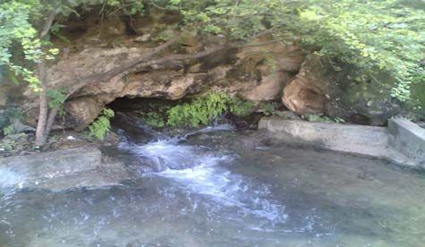
Sustainable management of the Salalah coastal aquifer in Oman using and integrated approach
اﻟﻤﺴﺘﺪاﻣﺔ ﻟﻠﺤﻮض ﻣﻘﺎرﻧ ًﺔ ﺑﺎﻟﺨﻴﺎر اﻟﺨﺎﻣﺲ .ﻳﺸﻴﺮ اﻻﺣﺘﻤﺎل إﻟﻰ ﺿﺮورة اﻷﺧﺬ ﻓﻲ اﻻﻋﺘﺒﺎر ﺗﻨﻔﻴﺬ
إﺟﺮاءات إﺿﺎﻓﻴﺔ ﺧﻼل اﻟﻌﻘﺪﻳﻦ اﻟﻘﺎدﻣﻴﻦ ﻟﻀﻤﺎن ﺗﻠﺒﻴﺔ إﻣﺪادات ﻣﻴﺎﻩ اﻟﺸﺮب ﻟﺴﺎآﻨﻲ اﻟﻤﺪﻳﻨﺔ .ﺗﻢ دراﺳﺔ
اﻟﺨﻴﺎرات اﻹدارﻳﺔ ﻋﻠﻰ ﺣﻮض ﺻﻼﻟﺔ اﻟﺠﻮﻓﻲ اﻟﺴﺎﺣﻠﻲ ،واﻟﺘﻲ ﻳﻤﻜﻦ أن ﻳﺘﻢ ﺗﻄﺒﻴﻘﻬﺎ ﻓﻲ ﻣﻨﺎﻃﻖ ﺁﺧﺮى ﻟﻬﺎ
ﻇﺮوف ﻣﺸﺎﺑﻬﻪ.
ﺗﻢ رﺑﻂ هﺬﻩ اﻟﺪراﺳﺔ ﺑﺎﻟﻌﻤﻞ اﻟﻤﻴﺪاﻧﻲ ﻟﺘﺠﺮﺑﺔ دراﺳﺔ هﻴﺪروﻟﻮﺟﻴﺔ اﻟﺴُﺤﺐ اﻟﻤﻮﺳﻤﻴﺔ وﺗﺪهﻮر اﻷﺷﺠﺎر ﻓﻲ
ﺟﺒﺎل ﻇﻔﺎر ودور اﻟﻤﻈﻠﺔ اﻟﺸﺠﺮﻳﺔ ﻓﻲ اﺻﻄﻴﺎد اﻟﻀﺒﺎب وذﻟﻚ ﺧﻼل ﻣﻮﺳﻢ اﻟﺨﺮﻳﻒ 2005-2003م .ﺣﻴﺚ
ﺗﻢ رﺑﻂ اﻟﻌﻤﻞ اﻟﻤﻴﺪاﻧﻲ ﺑﺎﻟﺪراﺳﺔ اﻟﻨﻈﺮﻳﺔ ﻟﺘﻘﻴﻴﻢ واﺧﺘﺒﺎر ﻧﺘﻴﺠﺔ اﻟﺘﻐﺬﻳﺔ اﻟﺘﺤﺖ ﺳﻄﺤﻴﺔ ﻣﻦ ﺟﺒﻞ اﻟﻘﺮا إﻟﻰ
ﻣﻜﻤﻦ ﺳﻬﻞ ﺻﻼﻟﺔ اﻟﺴﺎﺣﻠﻲ اﻟﻤﺸﺘﻘﺔ ﻣﻦ اﻟﻨﻤﻮذج اﻟﺮﻳﺎﺿﻲ اﻟﺬي ﺗﻤﺖ ﻣﻌﺎﻳﺮﺗﻪ وآﺬﻟﻚ ﻟﺘﻮﺿﻴﺢ أهﻤﻴﺔ
اﺳﺘﺪاﻣﺔ اﻟﻤﻈﻠﺔ اﻟﺸﺠﺮﻳﺔ ﻓﻲ ﺟﺒﺎل اﻟﻘﺮا ﺑﺎﻟﻨﺴﺒﺔ ﻟﻤﺴﺎهﻤﺘﻬﺎ ﻓﻲ اﻟﺘﻐﺬﻳﺔ اﻟﺠﻮﻓﻴﺔ .وﺗﻘﺪر ﻧﺘﺎﺋﺞ اﻟﻨﻤﺬﺟﺔ
اﻟﺮﻳﺎﺿﻴﺔ ﻟﻠﻤﻴﺎﻩ اﻟﺠﻮﻓﻴﺔ واﻟﻤﺤﺎآﺎة إﻟﻰ أن آﻤﻴﺔ ﻣﻴﺎﻩ اﻟﺘﻐﺬﻳﺔ اﻟﻄﺒﻴﻌﻴﺔ اﻟﺴﻨﻮﻳﺔ اﻟﺘﺤﺖ ﺳﻄﺤﻴﺔ اﻟﻘﺎدﻣﺔ ﻣﻦ
ﺟﺒﺎل اﻟﻘﺮا ﻟﺘﻐﺬﻳﺔ ﺣﻮض ﺻﻼﻟﺔ اﻟﺠﻮﻓﻲ اﻟﺴﺎﺣﻠﻲ ﺑﺤﻮاﻟﻲ 50ﻣﻠﻴﻮن ﻣﺘﺮ ﻣﻜﻌﺐ/اﻟﺴﻨﺔ ﻣﻘﺎرﻧ ًﺔ ﺑـ 53
ﻣﻠﻴﻮن ﻣﺘﺮ ﻣﻜﻌﺐ/اﻟﺴﻨﺔ اﻟﻤﺸﺘﻘﺔ ﻣﻦ اﺳﺘﺨﺮاج اﻟﻨﺘﺎﺋﺞ اﻟﻤﻴﺪاﻧﻴﺔ ﻟﻠﺘﺠﺮﺑﺔ اﻟﻤﺬآﻮرة .ﻗﺪرت اﻟﺪراﺳﺔ أن 60
إﻟﻰ %80ﻣﻦ ﻣﺠﻤﻞ اﻟﺘﻐﺬﻳﺔ اﻟﻄﺒﻴﻌﻴﺔ اﻟﺴﻨﻮﻳﺔ ﻟﺤﻮض ﺻﻼﻟﺔ اﻟﺠﻮﻓﻲ ﺗﺄﺗﻲ ﻣﻦ ﻋﻤﻠﻴﺔ اﻟﺘﺮﺳﻴﺐ اﻷﻓﻘﻲ
اﻟﺬي ﻳﺤﺪث ﻧﺘﻴﺠﺔ ﺗﺠﻤﻴﻊ اﻷﺷﺠﺎر ﻟﻤﻴﺎﻩ اﻟﻀﺒﺎب أﺛﻨﺎء ﻓﺼﻞ اﻟﺨﺮﻳﻒ.
ﻻ ﻟﻠﺸﻚ إﻟﻰ أهﻤﻴﺔ اﻟﻨﺒﺎﺗﺎتﺗﺜﺒﺖ اﻟﺘﺠﺮﺑﺔ اﻟﻌﻤﻠﻴﺔ ﻟﺪراﺳﺔ اﺻﻄﻴﺎد اﻟﻀﺒﺎب ﻓﻲ ﺟﺒﺎل ﻇﻔﺎر ﺑﻤﺎ ﻻ ﻳﺪع ﻣﺠﺎ ً
ﻓﻲ ﺟﺒﻞ اﻟﻘﺮا آﻤﺼﺪر رﺋﻴﺴﻲ ﻟﻠﺘﻐﺬﻳﺔ اﻟﺠﻮﻓﻴﺔ اﻟﺴﻨﻮﻳﺔ ﻟﻠﻤﻜﻤﻦ اﻟﺴﺎﺣﻠﻲ ﻣﻦ ﺧﻼل اﻟﻤﺴﺎهﻤﺔ ﻓﻲ اﻟﺘﺴﺎﻗﻂ
اﻷﻓﻘﻲ .وﻳﺸﻬﺪ اﻟﺠﺒﻞ اﻧﺨﻔﺎﺿًﺎ ﺳﺮﻳﻌًﺎ ﻓﻲ اﻣﺘﺪاد اﻟﻐﻄﺎء اﻟﻨﺒﺎﺗﻲ ،وهﻜﺬا ﻓﺈن آﻤﻴﺎت اﻟﻤﻴﺎﻩ اﻹﺿﺎﻓﻴﺔ
اﻟﻤﺘﻮاﻓﺮة ﻓﻲ اﻟﻤﺮاﻋﻲ ﻣﻦ ﺧﻼل اﺟﺘﺬاب اﻷﺷﺠﺎر ﻟﻠﻤﻴﺎﻩ اﻟﻀﺒﺎﺑﻴﺔ أﺧﺬت ﻓﻲ اﻟﺘﻨﺎﻗﺺ ،ﻣﻤﺎ ﻳﻌﻨﻲ اﻧﺨﻔﺎض
آﻤﻴﺔ اﻟﻤﻴﺎﻩ اﻟﻤﺘﻮاﻓﺮة ﻣﻦ هﺬا اﻟﻤﺼﺪر ﻟﺘﻐﺬﻳﺔ ﻣﺴﺘﻮدﻋﺎت اﻟﻤﻴﺎﻩ اﻟﺠﻮﻓﻴﺔ ﻓﻲ اﻟﺠﺒﻞ وﻓﻲ ﺣﻮض ﺳﻬﻞ
ﺻﻼﻟﺔ اﻟﺴﺎﺣﻠﻲ .
ﺗﻢ اﺗﺨﺎذ إﺟﺮاءات ﻣﻦ ﻗﺒﻞ اﻟﺤﻜﻮﻣﺔ ﻟﺘﺤﻔﻴﺰ اﺳﺘﺪاﻣﺔ اﻟﻤﻈﻠﺔ اﻟﺸﺠﺮﻳﺔ ﻓﻲ اﻟﺠﺒﻞ ﻣﻦ ﺧﻼل ﺗﺨﻔﻴﺾ إﻋﺪاد
اﻹﺑﻞ ﻓﻲ ﻣﺤﺎﻓﻈﺔ ﻇﻔﺎر اﻟﺘﻲ ﻣﻦ ﺧﻼل اﻟﺮﻋﻲ ﺗﻬﺪد اﻟﻐﺎﺑﺎت وﺧﺎﺻ ًﺔ ﺗﻠﻚ اﻟﻮاﻗﻌﺔ ﻋﻠﻰ ﻗﻤﺔ اﻟﺠﺒﻞ ﺧﻠﻒ
ﺳﻬﻞ ﺻﻼﻟﺔ اﻟﺘﻲ ﺗﺴﺎهﻢ ﻓﻲ ﺗﺮﺳﻴﺐ ﻣﻴﺎﻩ اﻟﻀﺒﺎب وﺑﺎﻟﺘﺎﻟﻲ ﻓﻲ ﺗﻐﺬﻳﺔ اﻟﻤﺴﺘﻮدع اﻟﻤﺎﺋﻲ اﻟﺴﺎﺣﻠﻲ ﺑﺼﻼﻟﺔ.
وﻗﺎﻣﺖ وزارة اﻟﺒﻠﺪﻳﺎت اﻹﻗﻠﻴﻤﻴﺔ واﻟﺒﻴﺌﺔ وﻣﻮارد اﻟﻤﻴﺎﻩ ﺑﺈﻧﺸﺎء ﻣﺸﺘﻞ ﻧﺒﺎﺗﻲ ﻓﻲ ﺟﺒﻞ اﻟﻘﺮا )ﻣﻨﻄﻘﺔ ﻗﻴﺮون
ﺣﻴﺮﺗﻲ 872 -ﻣﺘﺮ ﻓﻮق ﺳﻄﺢ اﻟﺒﺤﺮ( ﺑﻤﺤﺎﻓﻈﺔ ﻇﻔﺎر ﻓﻲ ﻋﺎم 2005م وﺳﻴﺘﻢ ﺗﻨﻔﻴﺬ ﺧﻄﻂ وﺑﺮاﻣﺞ هﺎدﻓﺔ
ﻻﺳﺘﺰراع أﻧﻮاع ﻣﺨﺘﻠﻔﺔ ﻣﻦ اﻟﻨﺒﺎﺗﺎت ﺑﻐﺮض إآﺜﺎرهﺎ وﻧﺸﺮهﺎ ﻋﻠﻰ ﻧﻄﺎق أوﺳﻊ ﻟﺘﻌﺰﻳﺰ ﺣﻤﺎﻳﺔ اﻷﺷﺠﺎر
اﻟﻤﺤﻠﻴﺔ وإﻋﺎدة اﻟﻐﻄﺎء اﻟﻐﺎﺑﻮي ﻻ ﺳﻴﻤﺎ وأن ﻣﺤﺎﻓﻈﺔ ﻇﻔﺎر ﺗﺤﺘﻔﻆ ﺑﺄآﺜﺮ ﻣﻦ 750ﻧﻮع ﻧﺒﺎﺗﻲ ،ﻣﻨﻬﻢ 50
ﻧﻮع ﻣﺴﺘﻮﻃﻦ ﻓﻲ اﻷﻗﻠﻴﻢ .هﺬﻩ اﻟﺪراﺳﺔ ﺗﺆآﺪ أهﻤﻴﺔ إﺟﺮاء ﺑﺮﻧﺎﻣﺞ ﻃﻮﻳﻞ اﻟﻤﺪى ﻟﺰراﻋﺔ اﻷﺷﺠﺎر ﺑﺎﻟﺠﺒﻞ
ﻹﻋﺎدة اﻟﺘﺄهﻴﻞ اﻟﻐﺎﺑﻮي وﺗﻐﺬﻳﺔ اﻟﺨﺰان اﻟﺠﻮﻓﻲ ﻟﻤﻴﺎﻩ ﺻﻼﻟﺔ .وﺗﺆآﺪ اﻟﺪراﺳﺔ اﻻﻗﺘﺮاح ﺑﺘﻨﻔﻴﺬ ﻋﻤﻠﻴﺎت
اﺳﺘﺰراع اﻷﺷﺠﺎر اﻟﻤﺤﻠﻴﺔ ﻓﻲ ﻣﻨﺎﻃﻖ اﻟﺤﺸﺎﺋﺶ ﻟﺘﻌﺰﻳﺰ اﺳﺘﺪاﻣﺔ اﻟﻐﻄﺎء اﻟﺸﺠﺮي ﻓﻲ ﺟﺒﺎل ﻇﻔﺎر ﺑﻐﺮض
ﺗﺤﻔﻴﺰ ﻋﻤﻠﻴﺔ ﺗﺠﻤﻴﻊ ﻣﻴﺎﻩ اﻟﻀﺒﺎب ﻣﻦ ﺧﻼل ازدﻳﺎد اﻋﺘﺮاض اﻷﺷﺠﺎر ﻟﻠﻀﺒﺎب وﺑﺎﻟﺘﺎﻟﻲ زﻳﺎدة ﻓﻲ إﻧﺘﺎﺟﻴﺔ
اﻟﺤﺸﺎﺋﺶ اﻟﻄﺒﻴﻌﻴﺔ ﻓﻲ اﻟﺠﺒﻞ واﻟﺘﻐﺬﻳﺔ اﻟﺠﻮﻓﻴﺔ اﻟﺴﻨﻮﻳﺔ ﻟﻤﻜﻤﻦ ﺻﻼﻟﺔ اﻟﺴﺎﺣﻠﻲ.
وﻓﻴﻤﺎ ﻳﺘﻌﻠﻖ ﺑﻤﺒﺪأ اﻟﺘﻐﺬﻳﺔ اﻟﺼﻨﺎﻋﻴﺔ ﺑﺎﻟﻤﻴﺎﻩ اﻟﻤﻌﺎﻟﺠﺔ ﻓﻲ اﻟﺸﺮﻳﻂ اﻟﺴﺎﺣﻠﻲ ﻟﺤﻮض ﺻﻼﻟﺔ ﻟﻜﺒﺢ ﺗﺪاﺧﻞ ﻣﻴﺎﻩ
اﻟﺒﺤﺮ ﻓﻘﺪ ﺗﻢ ﻃﺮﺣﻪ ﻣﻦ ﻗﺒﻞ اﻟﺒﺎﺣﺚ ﻓﻲ 1998م .ﺗﻢ وﺿﻊ ﻋﻤﻠﻴﺔ ﺗﺠﻤﻴﻊ وﻣﻌﺎﻟﺠﺔ ﻣﻴﺎﻩ اﻟﺼﺮف اﻟﺼﺤﻲ
ﻟﻤﺪﻳﻨﺔ ﺻﻼﻟﺔ وﻣﻨﺬ اﻟﻌﺎم 2003م ﺑﺪأت ﻋﻤﻠﻴﺔ اﻟﺤﻘﻦ اﻟﺠﻮﻓﻲ اﻟﻤﺒﺎﺷﺮ ﻟﻠﻤﻴﺎﻩ اﻟﻤﻌﺎﻟﺠﺔ ﻓﻲ ﺁﺑﺎر ﺟﻮﻓﻴﺔ
ﺑﻐﺮض ﻋﻤﻞ ﺣﺎﺟﺰ هﻴﺪروﺳﺘﺎﺗﻴﻜﻲ ﻟﻤﻨﻊ ﻋﻤﻠﻴﺔ ﺗﺪاﺧﻞ ﻣﻴﺎﻩ اﻟﺒﺤﺮ ﻓﻲ اﻟﺤﻮض اﻟﺴﺎﺣﻠﻲ .ﻓﻲ هﺬﻩ اﻟﺪراﺳﺔ
ﺗﻢ اﺧﺘﺒﺎر ﺗﺄﺛﻴﺮ اﻟﺠﻮاﻧﺐ اﻟﺘﻄﺒﻴﻘﻴﺔ ﻟﻠﻤﺨﻄﻂ اﻟﻤﺘﻌﻠﻖ ﺑﺎﻟﺘﺮﺷﻴﺢ اﻟﺼﻨﺎﻋﻲ ﻟﻠﻤﻴﺎﻩ اﻟﻤﻌﺎﻟﺠﺔ ﻟﻜﺒﺢ ﺗﺪاﺧﻞ ﻣﻴﺎﻩ
اﻟﺒﺤﺮ وذﻟﻚ ﺑﺎﺳﺘﺨﺪام اﻟﻨﻤﺬﺟﺔ اﻟﺮﻳﺎﺿﻴﺔ ﻟﺘﺪﻓﻖ اﻟﻤﻴﺎﻩ وﺣﺮآﺔ اﻷﻣﻼح ﻓﻲ اﻟﻤﻴﺎﻩ اﻟﺠﻮﻓﻴﺔ .ﺗﻢ ﻣﻘﺎرﻧﺔ اﻟﺒﻴﺎﻧﺎت
اﻟﻤﺸﺘﻘﺔ ﻣﻦ اﻟﻨﻤﻮذج اﻟﺮﻳﺎﺿﻲ ﺑﺒﻴﺎﻧﺎت اﻟﻤﺮاﻗﺒﺔ اﻟﻤﻴﺪاﻧﻴﺔ ﻟﻤﺸﺮوع اﻟﺘﻐﺬﻳﺔ اﻟﺼﻨﺎﻋﻴﺔ .ﺑﻴﻨﺖ ﻧﺘﺎﺋﺞ اﻟﻨﻤﺬﺟﺔ
اﻻﺣﺘﻤﺎﻟﻴﺔ ﻟﺘﺪﻓﻖ وﺣﺮآﺔ اﻷﻣﻼح ﻓﻲ اﻟﻤﻴﺎﻩ اﻟﺠﻮﻓﻴﺔ ﺑﺄن ﻋﻤﻠﻴﺔ ﺣﻘﻦ اﻟﻤﻴﺎﻩ اﻟﻤﻌﺎﻟﺠﺔ ﻓﻲ اﻟﺸﺮﻳﻂ اﻟﺴﺎﺣﻠﻲ
ﺗﺴﺎﻋﺪ ﻓﻲ ارﺗﻔﺎع ﻣﺴﺘﻮﻳﺎت اﻟﻤﻴﺎﻩ اﻟﺠﻮﻓﻴﺔ ﻓﻲ اﻟﻤﻨﺎﻃﻖ اﻟﻤﺠﺎورة ﻵﺑﺎر ﺧﻂ اﻟﺘﻐﺬﻳﺔ وﻣﻦ اﻟﻤﺘﻮﻗﻊ أن ﺗﻌﻤﻞ
ﻋﻠﻰ دﻓﻊ ﻧﻄﺎق اﻟﻤﻠﻮﺣﺔ ﻟﻠﺨﻠﻒ ﺑﻮاﻗﻊ 700ﻣﺘﺮ ﻓﻲ ﻋﺎم 2019م.
vi
Mahaad Shammas                                                                        TRITA LWR PhD Thesis 1031

ACKNOWLEDGMENTS

                      IN THE NAME OF THE ALMIGHTY
                                 ALLAH

I would like to express my sincere gratitude and appreciation to His Majesty Sultan Qaboos bin Said, Sultan of
Oman, may Allah protect him and to the Minister of the MRMEWR & his undersecretaries and the relevant Omani
Authority for giving me the opportunity to pursue higher studies.
I also wish to thank all those people who have made this project possible. I would like to acknowledge many people,
my family, friends and colleagues for help and support. First of all, I wish to express my deepest gratitude to my su-
pervisors Prof. Gunnar Jacks and Prof. Roger Thunvik at the Dept. of Land and Water Resources Engineering
(LWR) at the Royal Institute of Technology (KTH), Stockholm as well as Prof. Waleed Al-Zubari vice-Dean of
Technological Studies, College of Graduate Studies, Arabian Gulf University, Bahrain (the external advisor). In ad-
dition to providing their constructive comments, scientific guidance, valuable comments on my thesis, they have
provided helpful advice throughout the work on the thesis and in showing me how to look for the essence of
things. Their critical review of the thesis greatly improved its clarity.
This research was supported by a grant from the owner of Quality and Innovation Establishment Enterprises in the
Sultanate of Oman. I also wish to extend special thanks and appreciation to my elder brother Ali, the owner. In ad-
dition to providing continuous financial support, he has provided encouragement, motivation and advice along the
way.
I wish to extend my sincere gratefulness and appreciation to the MRMEWR staff, especially the staff of the GIS &
remote sensing, especially in the planning department, as well as to the staff of the DGEWRDG, especially to the
staff of the monitoring and studies section in DWR for support, encouragement and providing me with valued data
and information. It is a pleasure to thank the following for their assistance in various ways: Mansoor Mahwi Amer-
jeed, Abdullah Mohammad Baawain, Ali Abdullah Al-Makhzoom, Hussain Abdullah Al-Yafai and Salim Ahmed
Sakroon.
I also thank everybody at the dept. of LWR for creating a nice and friendly atmosphere in the everyday life. I wish
to record my appreciation to Prof. Emeritus Klas Cederwall, Prof. Per-Erik Jansson, Bo Olofsson, Jon Petter
Gustafsson, Prosun Bhattacharya, Prof. Bengt Hultman and Haile Estifanos, for sharing their knowledge and sup-
port. Furthermore, I wish to express my gratitude towards Aira Saarelainen, Ann-Catrine Norrström, Christina Ek,
Ann Fylkner, Lars-Erik Svahn, Jerzy Buczak, Britt Chow, Joanne Fernlund and Kerstin Indebetou for assistance
with all kinds of practical matters.
Thanks also to Olle Wahlberg, Arifuzzaman Mohammed, Ahmed Faruque Ferdous, Aziz Hasan, Dorothy Ferberg,
Jennifer McConville, Armin Hajivand and Samuel Azasu for the useful discussions, encouragement, support and
friendship. Thanks are also due to Paul Sharples of MRMEWR, Oman and Paul Wilkinson for the language correc-
tion.
I am most grateful to my brothers, Said, Ali and Salim, family and friends in Oman for their support and encour-
agement throughout all these years while doing this project. Many thanks are due to the family of my wife for their
hospitality to my daughter, Areej, in 2005 and care of my children. I am most grateful to the wife of my elder
brother Safa, and to my wife’s sisters for care and helping with my children.
Last but not least, special thanks to my beloved wife Muna, who took care of our children during the course of my
studies and to my children, who bore with me the difficult times of the project period and for understanding my
frequent absences.

                                                         vii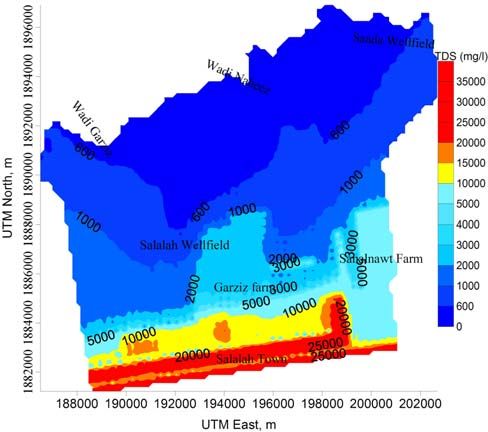
Sustainable management of the Salalah coastal aquifer in Oman using and integrated approach

                                            viii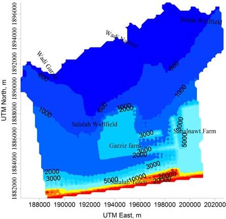
Mahaad Shammas                                                                                                          TRITA LWR PhD Thesis 1031

TABLE       OF CONTENTS
  Acknowledgments ........................................................................................................................................ vii
  Table of contents............................................................................................................................................ix
  Acronyms and Abbreviations.........................................................................................................................xi
  ABSTRACT .....................................................................................................................................................1
  Introduction.....................................................................................................................................................1
       Aims and objectives......................................................................................................................................2
       Previous studies............................................................................................................................................2
       Problem identification ..................................................................................................................................2
       Study approach.............................................................................................................................................3
       Outline of the study......................................................................................................................................3
  Description of the study area..........................................................................................................................3
       Evaporation on the plain ..............................................................................................................................4
       Hydrogeology...............................................................................................................................................5
  Groundwater development and management ...............................................................................................5
       Natural recharge...........................................................................................................................................6
          Vertical precipitation...............................................................................................................................6
          Horizontal precipitation..........................................................................................................................6
       Discharge from the groundwater ..................................................................................................................6
       Groundwater management ...........................................................................................................................6
       Monitoring of aquifer performance ..............................................................................................................7
         Recharge/flood protection dams ............................................................................................................7
         The direct injection of reclaimed wastewater...........................................................................................7
         Reduction of the camel population .........................................................................................................7
       Available measures to government................................................................................................................8
          Jabal reforestation...................................................................................................................................9
          Irrigation water distribution and efficiency of water use ..........................................................................9
          Seawater Desalination Plant ..................................................................................................................11
  Materials and Methods .................................................................................................................................11
       Numerical modelling development .............................................................................................................11
       Fogwater Collection experiment .................................................................................................................12
  Results and discussion..................................................................................................................................12
       Introduction...............................................................................................................................................12
       Piezometric surface ....................................................................................................................................14
       Solute transport..........................................................................................................................................15
       Mass balance analysis..................................................................................................................................15
       Model limitations........................................................................................................................................16
  Conclusion and Recommendations .............................................................................................................16
       Flow model- Conclusions...........................................................................................................................16
       Solute transport model– Conclusions .........................................................................................................18
       Recommendations......................................................................................................................................18
  References......................................................................................................................................................19

                                                                               ix
Sustainable management of the Salalah coastal aquifer in Oman using and integrated approach

                                            x
Mahaad Shammas TRITA LWR PhD Thesis 1031
ACRONYMS AND ABBREVIATIONS
Al-Rub Al-Khali the Empty Quarter
Ain Spring
cm centimetre
DCFC Dhofar Cattle Feed Company owns Garziz and Sahalnawt farms
D&M I; CDM Dames and Moore International; Camp Dresser and McKee, Inc
DGEWRDG Directorate General of Environment and Water Resources in Dhofar Gover-
norate, MRMEWR
DWR Department of Water Resources Affairs in the DGEWRDG
EC Electrical Conductivity
FAO Food and Agriculture Organisation of the United Nations
GDP Gross Domestic Product
GIS Global Information System
ha Hectares
HMR Hussam Mohammed Al Rawahi
Jabal Mountain
km kilometres
Khareef Monsoon
l/s litres per second
m amsl metres above mean sea level
mg/l milligrams per litre
mm/d millimetres per day
Mm3 Million Cubic Metres
μS/cm micro Siemens/cm, a measure of electrical conductivity (EC)
MAF Ministry of Agriculture and Fisheries of the Sultanate of Oman
MCM Million Cubic Metres
MRMEWR Ministry of Regional Municipalities, Environment and Water Resources of the
Sultanate of Oman
MWR (former) Ministry of Water Resources of the Sultanate of Oman
NWD Net Water Demand
NWI National Wells Inventory
OR Omani Rial, currently one OR equivalent to 2.58 US Dollars
PCDESR (former) Planning Committee for Development and Environment of the
Southern Region, Sultanate of Oman
PD-GIS The Planning Department-Geographic Information System section for
MRMEWR
SSDSCo Salalah Sanitary Drainage Services Company
STP Sewage Treatment Plant
TDS Total Dissolved Solids
Wadi Valley
yr Year
xiSustainable management of the Salalah coastal aquifer in Oman using and integrated approach
xiiMahaad Shammas TRITA LWR PhD Thesis 1031
ABSTRACT
A numerical flow model was developed for the Salalah coastal aquifer using both the MODFLOW computer code
and the MT3DMS computer code to assist in the analysis of freshwater flow and saltwater intrusion. The underflow
was derived from the developed numerical groundwater flow modelling and calibration on hydraulic heads of 1992.
A model-calculated water budget indicates that 51 million cubic metres per year of freshwater recharge the Salalah
plain aquifer system, of which 98% of this water is underflow originating from Jabal AlQara, and the remaining 2%
is the recharge on the plain.
Two baseline scenario simulations were run to calculate the potentiometric surface and salinity distribution for the
"business as usual" conditions (no-management interference) of the aquifer for the period 2006 until 2020. Baseline
scenario A, assumes "business as usual" and the underflow (constant recharge) to continue the same and baseline
scenario B, supposes "business as usual" and the underflow to decrease (changing recharge) at 5% annually. The ef-
fectiveness of seven scenarios under each baseline scenario proposed in this work was assessed in comparison with
the "business as usual" conditions. The developed simulation model was used to predict the distribution of the po-
tentiometric surface, salinity distribution, and mass balance under these proposed scenarios for the prediction pe-
riod 2006-2020.
The experimental work in Jabal AlQara was linked with the theoretical study of the flow model to optimize the re-
charge analytically in order to evaluate the output of the recharge that was obtained by the calibrated flow model.
The investigation of fogwater collection demonstrates the importance of the vegetation in Jabal AlQara as a source
of subsurface recharge by contributing to the horizontal precipitation. This project estimated that the horizontal
precipitation caused by fogwater capture by the Jabal vegetation, contributes to the annual natural recharge by 60%
to 80%. The experimental studies on fogwater harvesting in Dhofar demonstrated the importance of vegetation in
Jabal AlQara as the main source of the annual underflow to the Salalah coastal aquifer. The extent of tree cover
over parts of the Jabal is rapidly declining; in turn water from fogwater collection may decrease. This means that
there will be a decrease in the quantities of available water from this source to recharge the aquifers in the Jabal and
the Salalah aquifer.
Measures have been taken by the government to enhance the sustainability of the Jabal vegetation through the re-
duction of the camel population, which, by browsing, threatens the fogwater collecting forest on the mountain crest
behind the Salalah plain. In addition, the government (MRMEWR) established a plant nursery in Jabal AlQara (Qai-
roon hairriti- about 872 m amsl) to enhance the conservation as a result of transplantation of the indigenous plant
species to combat desertification and restore the plant canopy. The ecosystem of the Dhofar region supports more
than 750 terrestrial plant species, out of which about 50 are endemic. This study stresses the importance of imple-
menting a major programme to enhance fogwater collection. Tree planting in the Jabal grassland is proposed for re-
forestation with the principle purpose of causing an increase in fogwater interception to benefit grassland produc-
tion and increase the recharge of the Salalah groundwater aquifer.
This study investigated the effectiveness of the artificial infiltration, through the application of reclaimed treated
sewage recharge, to halt the salinity of the Salalah aquifer using a modelling technique. The study argues that the in-
jection scheme is effective in pushing back the saline zone front by 700 metres in 2019.
Ocean (Ghassemi, et al., 1996), Bahrain (Zubari et al.,
INTRODUCTION 1997, Zubari 1999, Al-Shabaani, A. H 1999, Zubari
2005 and Zubari & Lori 2005), United Arab Emirates
Most of the coastal areas around the globe depend
aquifers (Rizk et al., 1997), Lebanon (Sadek & El
totally on coastal aquifers as the major source of wa-
Fadel 1998), the Gaza Strip in Palestine (Yakirevich et
ter. There are many sources of groundwater con-
al., 1998, Hamdan, 1999 and Al-Yaqubi & Al-Jamal
tamination as a result of human influence such as
2002), the Nile Delta aquifer in Egypt (Amer, 1995,
seawater intrusion (Goudie, 1993). This problem is
Sherif & Amer 1995, Sherif, 1999 and Sherif & Singh
more severe in arid and semi-arid regions where the
2002), Cyprus and Rhodes (Greece) (Prieto, 2001),
groundwater constitutes the main freshwater re-
Coastal Alluvial Aquifer of Northern Oman-Eastern
source, as with the case of the Salalah plain aquifer.
Batinah coastal plain- (Weyhenmeyer & Waber
3% of seawater mixed with the freshwater in a
2002), Kuwait (Al-Murad, 1994 and Al-Rashed & Al-
coastal aquifer would render the freshwater resource
Senafy 2000) and the north-eastern coast of Australia
unsuitable for human consumption (Sherif & Singh
(Zhang, et al., 2004).
2002).
The Salalah plain is underlain by a shallow limestone
Seawater intrusion has been detected in many coastal
aquifer, which extends north up to the foot of Jabal
aquifer areas all over the world, as in the Quaternary
AlQara, and south to the Hafah coast (Fig. 1). Qua-
aquifer West of Tripoli, Libya (Belaid & El-Fateh
ternary deposits that include Wadi alluvium, a Cal-
1995), Tripoli, Libya (Sadeg, 1996), the coastal aqui-
carenite layer, underlain by limestone layers, consti-
fer in South and South East Asia (Jacks & Ra-
tute the Salalah aquifer. The coastal plain aquifer is
jagopalan 1996), Nauru Island in the central Pacific
1Sustainable management of the Salalah coastal aquifer in Oman using and integrated approach
a b
c
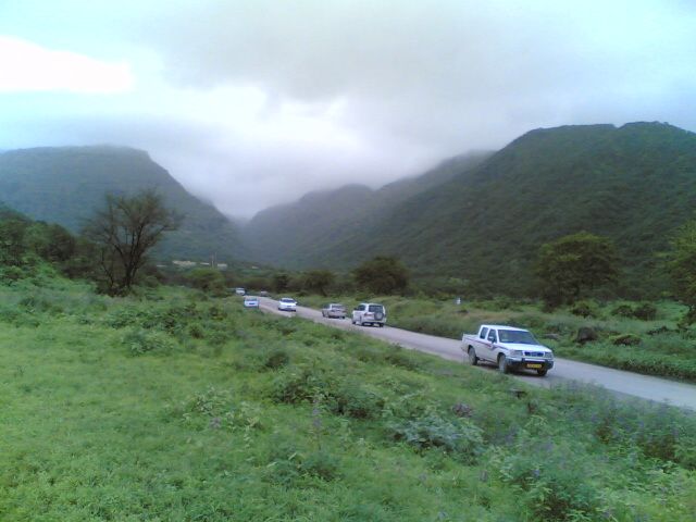
Fig. 1 The site location of the study area. Map of Sultanate of Oman (a), photograph of Salalah plain and Jabal Al-
Qara (b(, and satellite image of Salalah plain and adjacent Jabal Al-Qara (c).
historically the only natural source of water supply in 4. To study the relationship between the horizontal
the Salalah plain. Currently (2005) the average pump- precipitation in Jabal AlQara and groundwater
ing rate is more than the recharge rate. Seawater in- recharge, and the groundwater modelling of the
trusion has been reported in the Salalah plain aquifer plain aquifer (Paper 3).
by the author (1998 & 2002), and Geo-Resources 5. To design the aquifer sustainable management
(2004). This project uses MODFLOW, a three- options with which future management proc-
dimensional simulation flow model, steady state and esses for the Salalah coastal freshwater aquifer
transient in saturated zone flow, and MT3DMS for can be evaluated and assessed for proper man-
solute transport. The model is used to develop the agement using the established model (Paper 4).
aquifer domain and predict the water level variations
6. To study the effectiveness of reusing the treated
and salinity changes in the Salalah coastal aquifer and
wastewater on halting salinity intrusion into the
design the sustainable management of the aquifer.
Salalah plain aquifer (Paper 5).
Aims and objectives
Previous studies
The aim of the study was to determine a number of
The water resources of the Salalah plain and Jabal
options that could be implemented in the region to
AlQara have been studied by a number of Consult-
provide water services to the growing population as
ants, Ministries and Researchers since the mid-1970s.
well as to reduce the saltwater intrusion on the
(PAWR, 1986; WS Atkins, 1989 & 1990; Moot
groundwater resource currently being impacted by
MacDonald, 1996; COWIconsult, 1990 & 1992;
over-abstraction. This project proposed sustainable
FAO, 1992; D&MI, 1991, 1992, 1993 & 1997; De
management options for the plain aquifer and the
Jong et al., 1995; O’Boy, 1995; Milligan & Gharbi,
scenarios were examined using numerical modelling.
1995; Chebaane & Alesh, 1995; Al-Mashaikhi, 1997;
Each scenario predicted the aquifer hydraulic heads
ENTEC, 1998; Shammas, 1998 & 2002; the National
and salinity intrusion in the coming 15 years.
Water Resources Master Plan by Binnie, 1999; Elhag
The main objectives of this study are as follows: & Ghawas 2000; Baawain & Abu-Ashour 2002;
1. To determine the groundwater quality condi- Alesh, 1998 & 2003; Al-Hakmani, 2003; Qatan, 2003;
tions by investigating seawater intrusion (Paper Geo-Resources, 2004; HMR, 2004; Renardet, 2004;
1). Hildebrandt et al., 2004; Hildebrandt 2005; and
2. To provide a rational quantitative understanding Hildebrandt & Eltahir 2006.
of the hydrogeologic system of the Salalah plain
and establish the expected exhaustion of the aq- Problem identification
uifer with respect to the time (Paper 2). One of the main challenges in coastal aquifers is to
3. To use the established MODFLOW & provide the short-term water demand through ab-
MT3DMS numerical codes for the study and straction from the coastal aquifers while maintaining
simulate the hydrodynamics of the aquifer (Pa- long-term aquifer water balance. Increased extraction
per 1). of groundwater and reduction of flow towards the
2Mahaad Shammas TRITA LWR PhD Thesis 1031
coast has caused the saltwater interface to move the 30th January 2007. DOI:10.1007/s00254-
inland (Paper 1). This could further proceed due to 007-0673-2
the unbalanced situation in the aquifer water budget II. Shammas M. I. and Jacks G, 2006. Management
(Paper 2). of the Salalah aquifer, Oman. Submitted to
Consequently, seawater intrusion is expected to con- Hydrogeology Journal in the 20th June 2006.
tinue to increase, which will cause serious problems III. Shammas M. I., 2007. Impact of the Al-Qara
if solutions, such as the resource management op- mountain fogwater forest on groundwater re-
tions being proposed in this study, are not imple- charge in the Salalah coastal aquifer, Sultanate of
mented. To help with this problem, a pond injection Oman. The International Journal of Ecohydrol-
system was already proposed in 1998 (Shammas, ogy & Hydrobiology, Vol. 7, No 1, 37-49, 2007.
1998), but in view of the permeable aquifer condi-
IV. Shammas M. I and Thunvik R, 2007. Predictive
tions, well injection was chosen and the injection
simulation of flow and solute transport for man-
scheme started in April 2003. However, the 9.4 Mm3
agement of the Salalah coastal aquifer, Oman.
being injected till the end of 2005 is not sufficient to
Submitted to Water Resources Management
balance the water budget of the aquifer (Papers 1&
Journal in the 6th April 2007.
2).
V. Shammas M. I, 2007. The effectiveness of artifi-
Study approach cial recharge in combating seawater intrusion in
the Salalah coastal aquifer, Oman. Accepted for
The main approaches of this study are: - how to
publication in Environmental Geology Journal
bring balance between aquifer recharge and abstrac-
in the 20th January 2007.
tion? What are the available alternatives and the ef-
fectiveness of each in introducing an effective solu- Articles published or in press are reproduced by
tion to the problem? What is the best groundwater permission of the respective journals.
management methodology to be used to combat the
Salalah aquifer salinisation? DESCRIPTION OF THE STUDY AREA
Modelling has been done to investigate the plain aq- Salalah is a city located 1,100 km from Muscat the
uifer hydrogeological flow system (Paper 1 & 2) and capital. Salalah is the second largest city in the Sul-
to understand the effectiveness of the artificial infil- tanate of Oman with a population of 134,000 and a
tration scheme (Paper 5). In addition, the actual con- growth rate of about 2.2% a year (Oman Census
dition of the aquifer system and prediction of the 2003). Public administration accounts for 27% of the
groundwater situation due to present/future abstrac- total employment in Salalah (Oman census 1993
tion can be simulated by modelling, which can then data). This is followed by construction (16%), trading
subsequently be used for the evaluation/ suggestion (16%), manufacturing (9%) and agriculture (4%). It
of management scenarios to halt saline intrusion (Pa- was found that 18% of the area is being used for ag-
per 4). riculture out of the total developed area in Salalah.
The study was linked instrumentally with the field Agricultural net benefits contribute marginally to the
experiments on investigating the hydrology of a de- national economy (Sustainable management of the Salalah coastal aquifer in Oman using and integrated approach
a b
Fig. 2 The typical ecosystem in Jabal Al-Qara front (a) the road to Ain Garziz, and (b) Ain Tubrak (Sep. 2006)
from Umm Er Radhumma Formation. The springs Concerning the evaporation issue and its importance
in Salalah are also a tourist’s destination. Dhofar in the irrigation scheme on the Salalah plain, the au-
governorate has about 360 water springs, some of thor has executed a field survey, especially in the
which are perennial (flow constant), which include farms that irrigate grass crops. The survey concerns
Ain Sahalnawt, Razat, Tubrak etc. The water quality the timings of irrigation periods in the farms. The
found at Jabal front Ains (springs) is currently within survey took place between the 19th and 30th August
500 mg/l TDS, and there is an apparent strong link 2005. The author asked the farmers some questions
between Khareef rainfall and spring flow. such as: how many times per day do the farmers irri-
The industrial and commercial sectors in Salalah are gate their farms? How many cuttings do the farmers
also growing. The issuance of new laws and regula- make of the grass?
tions is encouraging local and international compa- Farmers irrigate grass crops on the Salalah plain as
nies to start work in Salalah, and this includes Royal follows:
Decree No. 62/2006 (that was issued in 20 June • During the hot months (i.e. March, April, May
2006) concerning the law on the establishment of a and June), the farmers irrigate the grass for two
Salalah free zone. Therefore, the water demand for to four hours between 16:00 and 20:00 hours
the industrial sector will also increase. and the next day not operational day.
Evaporation on the plain • During the Khareef season months (i.e. July and
August), the farmers irrigate the grass for two to
Regular monitoring of evaporation using the Piche
four hours between 16:00 and 20:00 hours and
method is carried out at only one site on the Salalah
then they will not irrigate the crops at all for the
plain- the Salalah airport at an elevation of 20 m
next four to five days.
amsl. The maximum average monthly evaporation
values occur during January, December, February • During the months of November, December
and November with a rate of 11.33, 11.15, 9.35 and and January, Salalah receives the northerly wind
9.13 mm/day, respectively. The lowest rates occur and sometimes the wind will be strong, espe-
during the Khareef when extensive cloud cover sig- cially during December and January, so the
nificantly restricts the evaporative potential, and an farmers irrigate the grass for two to four hours
average value of 2.23 and 1.75 mm/day occurs dur- between 16:00 and 20:00 hours every two to
ing July and August, respectively. The hot months three days.
(i.e. March, April, May and June), have average Farmers irrigate vegetables on the Salalah plain as
evaporation values of 8, 7.12, 5.85 and 5 mm/day, follows:
respectively.
• During the hot months (i.e. March, April, May
Maximum evaporation occurs during December, and June), vegetable irrigation lasts for five to six
January (>10 mm/day) and November, February (>9 hours between 15:00 and 20:00 hours and then
mm/day), with the lowest evaporation rates during there will be no irrigation for the next two to
the monsoon, typically between 2 and 4 mm/day three days.
(Renardet, 2004). The maximum mean evaporation
of about 11 mm/day is during January when the • During the Khareef season months (i.e. July and
most intense north winds occur and the lowest August), the farmers irrigate the vegetables for
evaporation mean is about 2 mm/day, during the five to six hours between 15:00 and 20:00 hours
cloud covered humid monsoon (O’Boy, 1995). and then there will be no irrigation for the next
seven to ten days.
The windy months are December and January, being
mostly northerly in direction. The rest of the year is • During the months, October, November, De-
between low to mid-speed winds, which are mostly cember and January, the farmers irrigate the
in a southerly northerly direction. vegetables for five to six hours between 15:00
and 20:00 hours each four to five days.
4Mahaad Shammas TRITA LWR PhD Thesis 1031
• During the strong winds the farmers irrigate the The second and third layers are the primary yielding
vegetables for five to six hours between 15:00 zones for domestic water supplies, as well as bore-
and 20:00 hours every two to three days. holes of the large farms, and occur on the eastern
The farmers irrigate during the evenings and night in and western margin of the central freshwater zone as
order to reduce the water evaporation losses. The a source for fodder crop irrigation. These large farms
farmers usually cut the grass after 45 days, so they cultivate grass as the major crop and the irrigation
make between 8-10 grass cuttings annually. The method is drip and spray (Chandler & Al-Abri 1995).
farmers in the Awqad area (west Salalah) mentioned Garziz farm is the largest commercial grass farm lo-
that they notice that the salinity on their farms is cur- cated in the freshwater zone, with a total cultivated
rently (2005) less than it was three to four years pre- area of 360 ha and uses 7.55 Mm3/yr. Sahalnawt
viously. All the surveyed farms were located south of farm is the second largest commercial grass farm lo-
the tube-wells of the re-injection scheme of the cated adjacent to the freshwater zone, with a total
treated sewage effluents into the Salalah plain aquifer area of 260 ha and uses about 6 Mm3/yr.
to halt saline intrusion. This may account for the arti- The main Salalah saturated aquifer layers are the up-
ficial recharge by the treated wastewater, since the per Alluvium layer of the Quaternary Age and the
operations of injection wells by the reclaimed water second layer of fractured limestone, deposited in the
along the coastal zone of the Salalah plain was com- Tertiary Age. The third saturated layer is marly lime-
menced in April 2003 and the project is still ongoing. stone, with low transmissivity and porosity. The vol-
ume of fresh groundwater in storage in the central
Hydrogeology freshwater zone was estimated by D&MI (1991) to
be about 340 Mm3 and estimated by Binnie (1999) at
The recharge to the aquifer zone in the Adawnib
362.5 Mm3. The Department of Water Resources
Formation takes place mainly from Khareef precipi-
(DWR) (1999) estimated the aquifer storage at 346
tation in the Jabal (paper 1). This water percolates
Mm3. This is the volume of groundwater with salinity
through the Umm erRhaduma of the Jabal and flows
(EC)Sustainable management of the Salalah coastal aquifer in Oman using and integrated approach
Natural recharge mated agricultural water demand in terms of net wa-
ter demand (crop consumption plus evaporation
Vertical precipitation losses) was approximately 62 MCM per annum for
The Dhofar region receives the monsoon season the 2,819 ha of net-cropped area irrigated. The huge
from late June to late September every year. During majority of volume of water used by irrigated agricul-
the Southwest monsoon, the mountains of Dhofar ture is not measured (only 4% of agricultural
are covered in a dense fog with frequent drizzle and bores/wells have meters (NWI, 1994).
light rain with a maximum duration lasting out the
monsoon. In most years more than 80% of total an- The net water demand in the agricultural sector is
nual precipitation falls during the summer monsoon calculated at 61 Mm3/yr (Geo-Resources, 2004).
months of June, July and August. Precipitation on Traditionally, the main area of agriculture on the
Jabal AlQara occurs as fine mist and rain and occult Salalah plain has been a 2 km coastal zone extending
precipitation from fog (Paper 3). The average annual some 20 km from Awqad in the west to Dahariz in
rainfall of Jabal AlQara and the Salalah plain is re- the east. These small farms produce a variety of
ported in several studies (Paper 3). crops, including coconuts, fruit, vegetables and grass
using water from wells dug in the Calcarenite (the
Horizontal precipitation upper layer). However, large-scale modern farms
Horizontal precipitation is known locally as the inter- have now been developed inland and these use water
action between trees and fogwater. The fog moisture from boreholes tapping both the fresh and brackish
collection of the Jabal Al Qara has been studied by a water zones. This increase in farming has created a
number of Consultants, Ministries and Researchers corresponding increase in water requirements, and a
since the end of the 1980s (Paper 3). The inhabitants number of private boreholes have been constructed
of the area have known about fog and mist water col- for this purpose.
lection in the Dhofar Mountains for many genera- Water resources are utilized for both urban and agri-
tions. Only a few decades ago the villages in the cultural consumption. The previous estimation of
Dhofar countryside had no access to piped domestic groundwater abstraction for agricultural demand in
water networks. Inhabitants harvested water by con- the plain aquifer of the Salalah groundwater basin
structing small reservoirs under large trees so they varies from one report to another. Most of the
could collect a lot of water during the monsoon sea- wells/boreholes of these farms do not connect to
son (Al-Khatheri, 1996). Currently, most of the in- flow metres. The exact annual abstraction by agricul-
habitants in the Dhofar Mountains have access to a ture, especially from the traditional farms, is not
reticulated water supply. known. Chandler & Al-Abri (1995) considered the
The numerical study was linked with the field ex- net agricultural demand at 62 Mm3; they also in-
periment (Hildebrandt, et al., 2004) in Jabal AlQara cluded the demand from Razat and Sahalnawt farms.
(Jojub) between the monsoon of 2003 and 2005. The This work excludes Razat farm and part of Sahalnawt
study investigated the relationship between the mon- farm consumption as they are outside the aquifer
soon, Jabal vegetations and fogwater interception, model domain of the eastern boundary. So, the net
landforms on the recharge of the Salalah plain aqui- agricultural demand is modelled in this study at 46
fer and computed analytically the underflow from Ja- Mm3/yr along the predictive period (Paper 4).
bal AlQara to the plain aquifer, to evaluate the aqui-
fer recharge optimized by the steady-state calibrated Groundwater management
flow model (Paper 3). What is being done about it? MRMEWR together
with MAF are providing the assessment, develop-
Discharge from the groundwater ment and management of the water resources in the
MRMEWR has initiated a programme of well regis- Dhofar Governate. Furthermore, the government
tration and set up a well inventory for the Salalah has implemented several measures to sustain the wa-
plain. National Well Inventory (NWI) properties sur- ter resources, which include the facts presented be-
veyed the total abstraction rates on the Salalah- low.
Taqah plain. According to the NWI (1994), the esti-
a b Fig. 3 Salalah central STP (Raysut area),
the aeration tank (a) and the collection
tank before discharge (b). Photograph by
the author (2004).
6Mahaad Shammas TRITA LWR PhD Thesis 1031
Monitoring of aquifer performance and protect Salalah City from flooding caused from a
DWR has regularly been monitoring the aquifer state temporary tropical cyclone. The cyclonic rainfall will
variables of the electrical conductivity and water lev- provide a significant recharge to the system, but it is
els since the early 1980s. A database for the EC and not expected to reverse any major increases in salin-
water levels of the plain aquifer has also been estab- ity as cyclones occur only on an occasional basis (Pa-
lished. The ministry (MRMEWR) integrated a moni- per 1).
toring network of rainfall, Wadis, springs gauges as The direct injection of reclaimed wastewater
well as wells, wetlands and dams which exceeds 4600 SSDSCo utilises a biological treatment system,
monitoring points and covers the most important ar- known as an activated sludge process, to achieve ter-
eas of the Sultanate. The staff monitoring water tiary treatment (Fig. 3). The client company expects
situations conducts routine monitoring visits, records that the plant will receive 20,000 m3 per day by the
the readings and updates the ministry water monitor- year 2007. The processes of the STP in brief are; the
ing network database. MRMEWR has a database for preliminary treatment (primary settling basins), the
monitoring changes in water levels and electrical secondary treatment (consists of aeration tanks and a
conductivity over a large part of the Salalah plain. settling tank) and the final process, disinfection (the
This database has allowed the author to develop a used disinfectant is chlorine), which is added before
calibrated aquifer model (Papers 1 to 5). The current discharge. The Salalah central sewage treatment plant
model should be used, updated and recalibrated as currently receives sewage water of some 18,000 m3
additional data become available to evaluate aquifer per day.
performance under a variety of different land uses
and management strategies. The STP effluents are treated to the tertiary level. Af-
ter the chlorination phase, effluents are discharged
Recharge/flood protection dams into a pipeline parallel to the coast and recharged
Recharge dams are useful for water resources devel- into tube-wells. The process aims to act as a hydrau-
opment. In addition to contributing to increase the lic barrier to combat saltwater intrusion and to partly
quantities of water resources and control seawater in- replace water abstracted from hand dug
trusion, these dams also act as barriers to control wells/boreholes further inland and downstream (Pa-
floods risks. On the Salalah plain, a 22 m high dam per 5).
was constructed in 1993 on Wadi Sahalnawt, near the The significance of the injection rates regarding the
Jabal front, north of Salalah. Sahalnawt dam has a water balance have increased from 2003 (Fig. 4). 90%
capacity of 6.4 Mm3 and has filled one time to date of the treated effluents daily are available for injec-
during the tropical cyclone in Dhofar, May 2002. tion, and the balance is currently discharged to Ray-
Unpublished data of the DWR recorded that 1.8 sut cement factory and Bir Bint Ahmed farm. The
Mm3 flowed over the main spillway of the dam dur- quantities of treated sewage effluents projected in
ing the cyclone event at (May 2002). The artificial re- this study, which are available for reuse, is about 6.6,
charge of the dam is assumed to be 75% (Al-Battashi 8.6 and 10 MCM for 2006, 2015 and 2020, respec-
& Syed 1998; and Atkins, 1989) of the stored vol- tively. These quantities are sufficient to irrigate be-
ume, i.e. 6.15 Mm3/yr. tween 273, 356 and 414 Ha, assuming a net water
During the last cyclone (May 2002), the existing Sa- demand at 24,170 m3/ha/yr as assumed by Geo-
halnawt dam was completely filled and some water Resources (2004). The use of treated wastewater on
even overflowed from the top of the dam to the ad- amenity plantings and water conservation measures
jacent Sahalnawt Wadi. The mid-part of Salalah was would also be appropriate.
flooded and the water was almost half a metre above
the ground surface in some areas and in roads and
Reduction of the camel population
low areas of the city itself. Most of the flooding that The government purchased about forty-five thou-
covered the mid-part of Salalah City was from the sand (45,000) camels from the owners in the Dhofar
Wadi Garziz flood. D&MI (1992) predicted that a Mountains during 2004 to 2005. The main aim was
cyclone would occur in the Dhofar region at a dura- to reduce the camel population, which in turn would
tion of once every seven to ten years. In June 1996, preserve the tree canopy in the Jabal. Camel brows-
April 1983 and June 1963, major cyclonic storms oc- ing threatens the fog forests in the mountains, espe-
curred in the Dhofar Governate. cially those on Jabal crest behind the Salalah plain,
that contribute in the plain aquifer recharge (Pa-
A design study for two recharge dams at Wadi Garziz
per 3).
in the central Salalah plain is currently underway with
a capacity of 15 Mm3. Only 75% of the stored vol- The number of animals in the Dhofar such as, sheep,
ume is assumed to be available as artificial recharge, goats, cattle and camels, were 7,605; 170,123;
which means that the existing Sahalnawt dam and 173,892; and 53,527 in 2005, respectively (Oman
two more flood control and recharge dams at a ca- livestock census, 2004-2005), whereas in 2002 the
pacity of 6.4 and 15 Mm3 would contribute in the re- numbers of goats, cattle and camels were 169,000;
charge by 16 Mm3 at times of a cyclone event like the 236,000; and 83,000, respectively. The camel popula-
one that happened in May 2002, i.e. equivalent to 2.7 tion has decreased from 83,000 in 2002 to 53,527 in
Mm3/yr. The dams will act as an artificial recharge 2005. This accounts for the camel population reduc-
7Sustainable management of the Salalah coastal aquifer in Oman using and integrated approach
Fig. 4 The artificial recharge rates from
12 the Salalah central STP effluents versus
time, 2003-2020
10
Volume, M cubic metres
8
6
4
2
0
2003
2004
2005
2006
2007
2008
2009
2010
2011
2012
2013
2014
2015
2016
2017
2018
2019
2020
Year
tion programme that took place in Dhofar between ble the current figures.
2004 and 2005. It is essential to extend the grazing So, is there is any way to bring the recharge to and
animals (camels and cows) depopulation project in abstraction from the aquifer into balance? Obviously,
the Governate of Dhofar so that livestock owners there is a need to introduce potential management
can benefit, while vegetation is used in a sustainable options to carry the aquifer to a balanced state (Ta-
manner. Saving the vegetation would enhance the ble 1). This is the main approach of this study.
horizontal precipitation and groundwater underflow.
It is obvious that the only solutions lie in developing
Available measures to government other freshwater sources or reducing freshwater de-
mand. The only potential source of new freshwater is
Salalah aquifer receives renewable water through the
annual recharge of the aquifer by the Khareef. This through desalination. Demand must be reduced
through reallocation of the fixed amount of freshwa-
study calculated the current (2005) average annual re-
charge to the aquifer at about 56 Mm3. However, the ter available, probably by limiting its use for agricul-
tural purposes. Although the majority of the work
current average annual abstraction from the aquifer is
65 Mm3. performed by the ENTEC (1998) study was directed
towards the qualitative study of the wellfields, they
Looking to the future, two things are obvious: stated that the problem of saltwater intrusion is es-
• Annual natural recharge to the aquifer will not sentially a quantitative “general” problem that can
increase (unless the reduction of the population only be solved by reducing the volume of abstrac-
of camels as well as long term tree canopy trans- tion.
planting in Jabal Al-Qara are continued and Potential groundwater management solutions to bal-
strengthened); and ance the coastal aquifer have been proposed (Pa-
• Annual demand for water from the aquifer will per 4). Table (1) shows the suggested management
increase. scenarios and their objectives. Predictive scenarios
were proposed and assessed using the numerical
Thus, the current annual deficit of over 9 Mm3 will
simulation model, in order to predict the extent of
increase over the coming 15 years to approach dou-
Table 1 Predictive scenario and their objectives
Prediction scenarios Objectives Percentage of reduction
1 Relocate Garziz and MAF farms far To see the impact of the relocation The abstraction will be re-
from the freshwater zone of the two big grass production duced by 17%
farms on the aquifer water balance
2 Suspend the abstraction of the grass To see the effect of this reduction This option will reduce the
production for 4 months a year on the aquifer, especially during 4 abstraction by 13%
months with high evaporation in
Salalah plain
3 Change in irrigation system pattern To see impact of the modern irri- This option will reduce the
gation system current abstraction by 20%
4 Establish the Desalination Plant To see the impact of the reduction This will reduce the projected
from the potable abstraction from abstraction from 14% to 15%
the municipal Wellfields on the between the year 2006 and
aquifer balance 2020
8Mahaad Shammas TRITA LWR PhD Thesis 1031
N S
Fig. 5 The vegetation covers on the Salalah plain and Jabal Al-Qara (from Miller and Morris, 1988)
water levels and salinity for the period 2006-2020 tion and restore the plant canopy. Miller & Morris
(Paper 4). (1988) mentioned that the ecosystem of the Dhofar
region supports more than 750 terrestrial plant spe-
Jabal reforestation cies, of which about 50 species are endemic (Fig. 5).
Three decades earlier there was an environmental
balance between natural resources and grazing activi- The relationship between numbers of livestock and
ties within the primary social and economic activity the available grazing areas are unbalanced as a result
in Dhofar Mountains. Currently more than half of of continuous grazing pressures on the grasslands.
the Dhofar indigenous species are about to become Currently the Jabal is facing severe overgrazing. Al-
extinct as a result of overgrazing (personal communi- Khatheri (1996) concluded that animal activities, es-
cations with Ahmed Al-Khatheri, MAF-Salalah, pecially overgrazing, had contributed greatly to the
March 2006). The population of the grazing livestock deterioration of natural grasslands in the Dhofar
(camels, cows and goats) has increased since the mid- Mountains. Natural grassland on the Jabal currently
1970s after the Omani renaissance. The government does not produce its full potential because of the ex-
has provided the Jabal inhabitants with needed ser- cessive grazing pressure problem. The importance of
vices, i.e. water, by drilling boreholes in the Jabal set- the concept of tree planting in Jabal AlQara for re-
tlements. The most significant cause of deterioration forestation and the recharge of the Salalah ground-
in the grasslands environment in the Dhofar region is water aquifer through fogwater harvesting has been
the increase in the number of animals and the result- stressed in this study (Paper 3). The higher the alti-
ing grazing pressure on the grasslands. tudinal range above sea level the higher the potential
for fogwater interception in the Dhofar Mountains
Jabal reforestation and combating desertification in (Barros & Whitcombe 1989).
Dhofar have been investigated by several studies
since the early 1980s. Atkins (1989) recommended Irrigation water distribution and efficiency of water use
policies for the Jabal reforestation in the regional de- There is a requirement to control agricultural water
velopment plan produced for the Dhofar Governate use in the Salalah plain. To put this into effect, MAF
on behalf of PCDESR. Travers Morgan (1995) stated would take responsibility for supplying water to
that the planting of 2,000 to 4,000 ha of trees on the farms through a main distribution system to individ-
Jabal will greatly improve Khareef recharge. Few of ual farms. Water input into the system would be bal-
these proposed plans for the Jabal reforestation and anced by having different abstraction rates from dif-
anti-desertification in the Dhofar Mountains have ferent wells in the region for the overall benefit of
been implemented to date. the aquifer. A metered output, providing a fixed
MAF in the 1990s fenced a couple of areas in the Ja- amount of free water in accordance to the farm size,
bal to conserve the existing genetics of the indige- would be allocated to each farm. Any water con-
nous plants in the Jabal. The government sumed above this amount would be charged for. This
(MRMEWR) established a plant nursery in Jabal would encourage farmers to practice efficient irriga-
AlQara (Qairoon hairriti- about 872 m amsl) in 2005 tion and allow smallholders to conduct very concise
to enhance the conservation of the indigenous plant control over their water.
species through transplanting to combat desertifica-
9You can also read