Feasibility Study for the Lough Conn/ Lough Cullen Recreational Trail Network - Knockmore Rathduff ...
←
→
Page content transcription
If your browser does not render page correctly, please read the page content below
Feasibility Study for the Lough Conn/ Lough Cullen Recreational Trail Network Compiled by: Meehan Tully & Associates Ltd. : + 353 71 9146500 | info@meehantully.com | : www.meehantully.com Mentoring and Business Support | Strategic Planning | Training | Community Development | Excellence Through People

This Study has been undertaken with the assistance of the LEADER Programme 2014-2020

 The European Agricultural Fund for Rural Development: “Europe investing in rural areas”
Feasibility Study for the Lough Conn/ Lough Cullen Recreational Trail Network

EXECUTIVE SUMMARY ...................................................................................................................... III
1.       INTRODUCTION......................................................................................................................... 1
     THE PROJECT ........................................................................................................................................... 1
     INTRODUCTION TO THE PROMOTERS............................................................................................................. 2
         Walking Trails ................................................................................................................................. 3
         Walking in Mayo ............................................................................................................................. 3
         Mayo Walks .................................................................................................................................... 4
         Recreational Trails .......................................................................................................................... 5
         Greenways ...................................................................................................................................... 5
2.       KNOCKMORE AND PONTOON ................................................................................................... 6
     LOCAL HERITAGE ...................................................................................................................................... 7
         Built Heritage .................................................................................................................................. 8
         Natural Heritage ............................................................................................................................. 9
     LOCAL ATTRACTIONS AND AMENITIES ......................................................................................................... 11
         Angling .......................................................................................................................................... 12
         Local Walking and Cycling Trails ................................................................................................... 13
         Local Recreational Amenities ........................................................................................................ 14
         Walking Festivals and Clubs .......................................................................................................... 15
         Planned Developments for the Region .......................................................................................... 16
3.       POPULATION OF CATCHMENT AREA ....................................................................................... 18
     DEMOGRAPHICS/ POPULATION STATISTICS OF CATCHMENT AREA .................................................................... 18
         Population ..................................................................................................................................... 19
         Age profile of population, Census 2016 ........................................................................................ 19
         Size of households, Census 2016 ................................................................................................... 20
         Family Cycle, Census 2016............................................................................................................. 21
         Disability, Census 2016 .................................................................................................................. 21
         General Health, Census 2016 ........................................................................................................ 21
         Number of carers, Census 2016 .................................................................................................... 21
         Means of travel to work, school or college, Census 2016 ............................................................. 21
         Travel time to work, school or college, Census 2016 .................................................................... 22
         Time of leaving for work, school or college aged 5+ ..................................................................... 22
         Employment by sector ................................................................................................................... 22
         Access to internet .......................................................................................................................... 22
4.       PROJECT COST ......................................................................................................................... 23
     DEPARTMENT OF TRANSPORT TOURISM AND SPORT GREENWAY STRATEGY FUNDING .......................................... 23
     DEPARTMENT OF RURAL AND COMMUNITY DEVELOPMENT OUTDOOR RECREATION SCHEME ................................ 23
     DEPARTMENT OF RURAL AND COMMUNITY DEVELOPMENT TOWN AND VILLAGE ENHANCEMENT SCHEME ............... 23
     LEADER/ RURAL DEVELOPMENT PROGRAMME ............................................................................................. 24
     FAILTE IRELAND GRANTS SCHEME FOR LARGE TOURISM PROJECTS ................................................................... 24
5.       ECONOMIC POTENTIAL ........................................................................................................... 25
     ECONOMIC BENEFITS OF WALKING AND CYCLING PROJECTS .............................................................................. 25

                                                                                                                                                             i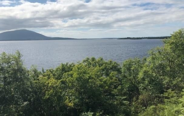
Feasibility Study for the Lough Conn/ Lough Cullen Recreational Trail Network

         Economic Analysis for a Trail ........................................................................................................ 26
         Net Visitor Expenditure ................................................................................................................. 28
         New to the Economy - Net Additional Expenditure ....................................................................... 31
     HEALTH BENEFITS OF TRAILS ..................................................................................................................... 32
6.       POLICY CONTEXT ..................................................................................................................... 34
     PROJECT IRELAND 2040 (NATIONAL PLANNING FRAMEWORK) ........................................................................ 34
     STRATEGY FOR THE FUTURE DEVELOPMENT OF NATIONAL AND REGIONAL GREENWAYS (2018) ............................ 35
     MAYO LOCAL ECONOMIC AND COMMUNITY PLAN (LECP) ............................................................................. 36
     MAYO COUNTY DEVELOPMENT PLAN (CDP) 2014-2020 ............................................................................. 37
     DESTINATION MAYO A STRATEGY FOR THE FUTURE DEVELOPMENT OF TOURISM IN COUNTY MAYO
     2016 – 2021........................................................................................................................................ 39
     MAYO COUNTY WALKING STRATEGY AND STRATEGIC ACTION PLAN ................................................................. 41
     MAYO SPORTS PARTNERSHIP STRATEGIC PLAN 2017 – 2021 ......................................................................... 42
     IRISH TRAILS STRATEGY (2007) ................................................................................................................. 43
     NATIONAL COUNTRYSIDE RECREATION STRATEGY (2006) .............................................................................. 43
     STRATEGIC OBJECTIVES IDENTIFIED FOR THE STRATEGY ARE: ............................................................................ 44
     A STRATEGY FOR THE DEVELOPMENT OF IRISH CYCLE TOURISM 2007............................................................... 44
     WILD ATLANTIC WAY OPERATIONAL PROGRAMME 2015-2019 ..................................................................... 45
     POLICY SUMMARY .................................................................................................................................. 45
7.       MANAGEMENT ....................................................................................................................... 46
         Management Structure ................................................................................................................. 46
     MAINTENANCE ....................................................................................................................................... 47
         Trail Inspection .............................................................................................................................. 47
         Safety ............................................................................................................................................ 48
         Insurance ....................................................................................................................................... 48
8.       MARKETING ............................................................................................................................ 49
     PROMOTIONAL ACTIVITIES ........................................................................................................................ 49
         Branding ........................................................................................................................................ 49
         Digital Media................................................................................................................................. 50
         Familiarisation Visits ..................................................................................................................... 50
         Print Material ................................................................................................................................ 51
     SIGNAGE ............................................................................................................................................... 51
         Trail Information ........................................................................................................................... 51
         Interpretation ................................................................................................................................ 52
9.       ACTION PLAN .......................................................................................................................... 54
10.      S.W.O.T. ANALYSIS.................................................................................................................. 55

                                                                                                                                                             ii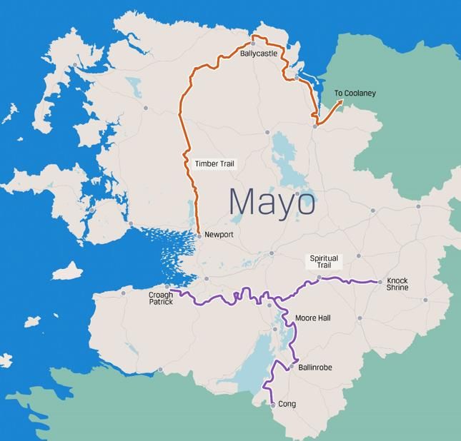
Feasibility Study for the Lough Conn/ Lough Cullen Recreational Trail Network

Executive Summary
Vision
The community’s vision for this proposed development is to create a greenway-type trail along the
shores of Lough Conn/ Lough Cullen, between Knockmore and Pontoon, as a free, family-friendly
recreational amenity. It will provide a safe, off-road link between the two ends of the community
as well as forming a key strategic part of Mayo County Council’s wider plans for a long distance
linear greenway connecting Ballina and Castlebar to the comprehensive system of walks, sites,
activities, trails and attractions found throughout County Mayo.

Description
The Lough Conn/ Lough Cullen Recreational Trail Greenway will be an almost 9km long amenity
from Pontoon to Knockmore, with the potential for linkages to Foxford in the short-term, and to
other areas of the County in the longer term, depending upon funding availability. The trail route
skirts the shoreline of both loughs and crossing the isthmus that separates them. This is an area
rich in heritage and cultural associations, as well as being a well-known destination for angling and
outdoor activities. The project will increase the region’s recreation infrastructure and boost its
reputation as a destination for adventure activity. In doing so, the Lough Conn/ Lough Cullen trail
will offer a significant opportunity to open surrounding disadvantaged rural communities to
tourism thereby increasing visitor numbers, lengths of stay, and spending, which will have a
positive impact upon these communities and their economies and will encourage and support new
enterprise and job creation.

Encouraged by the experience of the Great Western Greenway and other similar projects, and the
identification of the area in the County Development Plan as a location for greenway development,
residents of the area formed a Knockmore Pontoon Community Development Group in 2016 to
promote the development of a recreational trail along the loughs.             With LEADER/ Rural
Development Programme support, the group commissioned a feasibility study and a technical
feasibility study for the proposed amenity. This project, once delivered, will not only provide the
region with a flagship family-friendly visitor attraction, one that opens up the surrounding area to
visitors and provides connectivity with other important regional attractions and infrastructure, but
it is also an environmentally sustainable project that encourages improved health and wellbeing
through outdoor activity.

                                                                                                   iii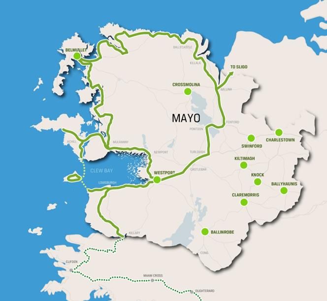
Feasibility Study for the Lough Conn/ Lough Cullen Recreational Trail Network

Project Stakeholders
The Knockmore Pontoon Community Development Group is the primary stakeholder, and
promoter, of the project and in this regard they enjoy considerable support from local community,
to include businesses, organisations, clubs and residents. Others potential key stakeholders with
an interest in the planning, delivery, and operating of the recreational trail include Mayo County
Council, Fisheries Ireland, and The National Parks and Wildlife Service (NPWS), as well as local
landowners.

As the potential lead applicant for funding for the project, the Group will assume responsibility for
its delivery, upkeep and maintenance, and insurance, though the Local Authority may be able to
provide some supports in this regard, e.g. insurance cover, etc. The Group will form a Steering
Group comprised of representatives from the community, landowners, the County Council, and
other stakeholder bodies and organisations to oversee the management, marketing and
promotion, and long term planning for the trail.

Trail Cost
The cost of constructing a 9km long trail is estimated to be in the region of € 1,437,300.

Economic Potential
The projected number of new visitors arising from the development of the Lough Conn/ Lough
Cullen Recreational Trail has been based upon Bord Fáilte and CSO research, collated from reports
such as Regional Tourism Performance 2016 (Revised March 2018) and Tourism Facts 2017
(Published 2018), which indicates that 30.6% of overseas tourists and 33% of domestic tourists
participate in hiking, walking and/ or cycling as an activity.

For the purposes of this Business Plan, the impact of the trail has been reviewed in terms of
attracting new visitors to the area, both domestic and overseas.

                                                                                                   iv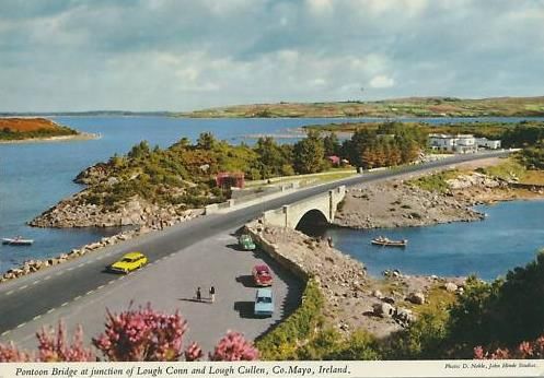
Feasibility Study for the Lough Conn/ Lough Cullen Recreational Trail Network

1. Introduction
The Project
Knockmore and Pontoon are two small
rural settlements located in north
County    Mayo     along    the   south/
southeast corner of Lough Conn, west
of Foxford town. Knockmore is a small
village serving the local area with a
limited range of services and amenities.
Situated on an isthmus separating the
                                                                   Knockmore Bay
two bodies of water that define the
wider local region, Lough Conn and Lough Cullen, Pontoon is a smaller, more dispersed settlement at the
western edge of the project area. Tributaries of the River Moy, a Special Area of Conservation (SAC), the
loughs are considered to be two of Ireland’s best lake trout fisheries and part of an important salmonid
fishery. The primary route between the two villages, and the two loughs, is the R310. As a secondary route
between Castlebar to the south and Ballina to the north, the road carries considerable traffic much of which
travels in excess of the posted 80km speed limit. The area is also home to several small businesses, a range
of community facilities, and approximately 25 active community organisations and clubs.

For many years residents of the area have been proposing the
development of recreational amenities along Lough Conn, specifically
at Tawnaghmore to the south of Knockmore. In 2016, residents of
the two villages came together, joining with the existing
Tavanaghmore Residents Group and the Twin Lakes group, to form
the Knockmore/Pontoon Development Group (hereafter referred to
as the ‘promoters’).       The aim of the Group, as stated in its
Constitution, ‘is to develop the tourism and recreational potential of
the Knockmore/Pontoon area in order to showcase its unique natural
beauty and biodiversity.’ Recognising the significant benefits of
walking and cycling amenities to local populations, and their potential
for enhancing the area’s tourism product/ visitor experience and the
local economy, the promoters wish to ‘harness the scenic potential of
this beautiful and neglected area and create a recreational experience
for locals and visitors alike.’ Towards this objective, the Group

                                                                                                          1
Feasibility Study for the Lough Conn/ Lough Cullen Recreational Trail Network

propose the development of an off-road recreational walking and cycling amenity linking Knockmore Bay
to Pontoon.

The proposed lakeshore trail, which will be approximately 9km in length when completed, will allow safe
travel between the two village areas, and between the westerner and eastern shores of Lough Conn,
thereby facilitating further access on to Castlebar to the south and Ballina to the north. The trail offers
considerable potential to revitalise the area’s tourism product, which has suffered considerably in recent
years with the closure of Pontoon’s two landmark hotels, Healy’s and the Pontoon Bridge. The proposed
trail will enhance the tourism amenity value of the area in an environmentally friendly and sustainable
manner and will encourage recreational activity leading to healthier lifestyles.        Furthermore, the
development of a trail at this location will offer opportunities for forming linkages with existing and
proposed trails, blueways, and other recreational amenities in the wider region, which will encourage and
support economic activity and job creation.

Introduction to the Promoters
The promoter, Knockmore/Pontoon Development Group, is a community group representing local
residents, businesses, clubs, and organisations. The Group is comprised of a committee of    members
oversee the activities of the Group on behalf of the wider membership of approximately       community
members. Presently, the officers of the Group are as follows:

     Name                       Position                        Occupation
     Mary Lester                Chairperson                     College Lecturer
     P.J. Duffy                 Assistant Chairperson           Branch Manager, Builders’ Providers
     Shirley Corcoran           Secretary/ Treasurer            Local Business Owner
     Mary Nallon                Assistant Secretary             Community Worker

In support of its aim to develop the tourism and recreational potential of the area, and specifically the
development of a lakeshore trail, the promoters have consulted widely with the community, Mayo County
Council, and other local stakeholders. They have raised more than €8,000 through fundraising activities
and successful applied for LEADER/ Rural Development Fund grant aid to commission a Feasibility Study
and a Technical Study for the project. The Group appointed Meehan Tully & Associates Ltd. to carry out
this Feasibility Study, which along with the accompanying Technical Study prepared by Roughan &
O’Donovan Consulting Engineers, presents the most appropriate and sustainable case for undertaking the
development of the proposed Trail to meet the needs of the local area.

                                                                                                         2
Feasibility Study for the Lough Conn/ Lough Cullen Recreational Trail Network

Walking Trails
Throughout Europe, the development of dedicated walking and cycling trails, especially off-road and loop
trails, is increasing as communities come to recognise the social, recreational, health and well-being,
environmental, and economic value of such amenities to local areas and populations. This has been
especially true in Ireland where in recent years new walks and trails have and are being constructed for
public use and enjoyment by communities, Local Authorities, State Agencies, and private individuals. The
National Trails Office (NTO), which was established in 2007 to create and maintain safe and accessible
recreational trails throughout Ireland, currently lists a total of 939 trails of all description as being registered
with the Office.       A total of 43 of these are
designated medium to long distance walking
routes referred to as National Waymarked Trails,
two which, the Croagh Patrick Heritage Trail and
the Mayo Way are located in County
Mayo.

Much     of   recent    growth    in   trail
development in Ireland has occurred
since the opening of the first section of
the Great Western Greenway in 2010,
which has resulted in County Mayo gaining an
international reputation for recreational walking
and cycling activity. Mayo’s success in this regard
is a direct outcome of the implementation of its
                                                          National Waymarked Trails (source:www.irishtrail.ie)
2007 Walking Strategy, which identified as an
objective the specific goal of establishing Mayo as the ‘walking capital of Ireland’. Presently, 93 of the trails
registered with the NTO and appearing on its website (www.irishtrails.ie), a tenth of the total 939 trails, are
located in County Mayo alone, as depicted on the map above.

Walking in Mayo
With the support of Mayo County Council, Mayo County Development Board, and other stakeholders, the
Mayo Walking Partnership to implement the Walking Strategy a direct outcome of which was the
appointment of a Walking Development Officer and the development of a dedicated website for walking in
the County mayowalks.ie. In 2009, Mayo was identified as the location for a National Cycle Network
greenway pilot project, which resulted in the Great Western Greenway (GWG), a 42km off-road, shared-
use cyclist and walking trail running between Westport and Achill. Constructed at a cost of approximately
€6 million, its development was made possible by agreement with approximately 160 local landowners who

                                                                                                                  3
Feasibility Study for the Lough Conn/ Lough Cullen Recreational Trail Network

gave permissive access for the public to cross their land. It is the longest off-road cycling trail in Ireland and
forms part of the National Cycle Network. Funding for its construction was sourced from Failte Ireland, the
Department of Transport, and the Department of Community, Gaeltacht and Rural Affairs, and Mayo
County Council’s own resources. It was reported by Mayo County Council that approximately 265K persons
travelled all or portions of the trail in 2014 and approximately 200 jobs have been created in local areas as
a result. The trail has been named as the Irish winner of the European Destination of Excellence Award. An
economic assessment carried out on the project estimated that 40 jobs were created and another 50
retained in the local economy as a result of the investment.

Mayo Walks
Mayo Walks is Mayo County Council 's website portal for promoting the County’s extensive network of
mountain, coastal, urban, and rural walking and cycling trails. It provides information in relation to trail
location, length, level of difficulty, terrain, etc., as well as route maps. The following image provides an
indication of the number of linear and loop walks presently available in the County.

                                Mayo Walks May (source: www.mayowalks.ie)

                                                                                                                4
Feasibility Study for the Lough Conn/ Lough Cullen Recreational Trail Network Recreational Trails As noted, County Mayo has an established an international reputation as a destination for walking and cycling due to the extent of trail network throughout the County and because of the recent success of the Great Western Greenway (GWG) project. In general terms, cycling and walking trails and greenways can be classified as off-road, on-road and shared use, as described in the following sections below. Off-road trails These include paths through parks, forestry lands, etc., that are designated for walking and or cycling and where vehicular traffic is prohibited. Also, specifically designed mountain bike trails. On road trails These are generally waymarked touring trails on public roads, e.g. sections of the Western Way. The public roads designated for walkers and cyclists are typically those with low traffic volumes. Shared-use/ greenways Trails catering for different users such as walkers and cyclists, and sometimes horse riders, are referred to as ‘shared-use trails’, or greenways. This type of trails is designed to ensure that the width is sufficient and the trail finish appropriate to the needs of the various authorised users. The National Trails Office’s Classification and Grading for Recreational Trails recommends shared-use trails be at least 2-3 metres in width to allow for other users and have sealed or compacted surfaces with minimal loose material (
Feasibility Study for the Lough Conn/ Lough Cullen Recreational Trail Network

2. Knockmore and Pontoon
Situated midway between the towns of Castlebar (23km) and Ballina (12km), at a strategic crossing point
between Lough Conn to the north and Lough Cullen to the south, Pontoon (Pont Abhann, ‘river point’) is a
renowned angling destination for fishermen. Nearby Knockmore (Cnoc Mór, ‘great hill’) hosts the local
parish church, a shop, public house, school, community resource centre, and playing pitches. According to
Irish folklore, the two loughs were created when Fionn MacCumhaill was hunting boar with his two hounds,
Conn and Cullin. Water began flowing from the boar’s feet as the dogs gave chase. Eventually, after several
days chase the water formed two deep pools, Lough Conn and Lough Cullen, in which the dogs drowned.

An area with a dispersed settlement pattern and little local
economic activity other than agricultural, Knockmore/Pontoon
was until relatively recently a popular visitor destination
featuring two long established hotels, the Pontoon Bridge and
Healy’s, both of which have since closed. From the 1960s, until
its closure in the 1980s, Pontoon Ballroom was a major feature of the area attracting audiences from the
surrounding region. The building, which was located adjacent to the now closed Pontoon Bridge Hotel, has
since been demolished.

The development of a recreational trail will not just facilitate safe access between the villages and provide
opportunities to experience natural and built heritage amenities but will also encourage new economic
activity in the wider area. The following section provides a brief overview of some of the local attractions
offering potential for interpretation and promotion as a means increasing the amenity value and
attractiveness of the area’s tourism product.

                                                                                                           6
Feasibility Study for the Lough Conn/ Lough Cullen Recreational Trail Network
Local Heritage
The section provides a summary of the natural and built heritage value of the Knockmore/ Pontoon area
and the attractions and amenities that exist in close proximity to the two villages. This information is
provided to give an indication of the existing amenity value of the area, and its tourism product, and the
potential for developing and enhancing archaeological sites, habitats, built structures, coastal areas, and
other features in future.
The Knockmore/ Pontoon area is on of outstanding natural beauty and significant natural and built heritage
value. The lakeshores and adjacent areas possess an abundance of historic sites to include numerous
crannogs and enclosures, as well as important habitats protected under European and Irish legislation, e.g.
Special Area of Conservation (SAC) and Special Protection Area (SPA). The two following maps visually
depict the extent of recorded built heritage and designated natural heritage sites found in the immediate
vicinity of the proposed trail route. These sites, and the scenic views and settings in which they are located,
provide considerable amenity value for future trail users.
Knockmore/ Pontoon Area Built Heritage Sites (source: webgis.archaeology.ie)
Knockmore/ Pontoon Area Built and Natural Heritage Sites (source: map.geohive.ie)
7Feasibility Study for the Lough Conn/ Lough Cullen Recreational Trail Network
Built Heritage
In addition to numerous national monuments, i.e. built heritage sites pre-dating 1700 and included in the
Record of Monuments and Places (RMP) – shown as red dots on the previous maps - the Knockmore/
Pontoon area contains several built structures from more recent periods. Due their historic significance,
two local structures are included on both the Mayo County Development Plan’s Record of Protected
Structures (RPS) and the Department of Arts, Heritage and the Gaeltacht’s National Inventory of
Architectural Heritage (NIAH), and two additional structures also included on the NIAH, as presented in the
tables below. With the exception of the Church of Christ the King, all the structures below are located in
Pontoon.
RPS No. Record of Protected Structures Description
0149 Pontoon Lodge
0150 House (A) beside
Pontoon Lodge
NIAH No. National Inventory of Architectural Heritage Description
31304801 Church of Christ the King - Detached five-bay
double-height Catholic church, under construction
1837; extant 1838; dated 1840; completed 1845
0150 Former Pontoon Hotel (Pontoon Lodge) -erected by
Richard Bingham (1764-1839), second Earl of Lucan,
'a small comfortable Inn for the accommodation of
strangers' (Fraser 1838, 343)
31306003 Former Constabulary Barrack - Detached three-bay
two-storey police station, extant 1838, on a
symmetrical plan. In use, 1901
31306004 Former Handball Alley - allegedly erected for
recreational use by officers stationed at the
adjacent constabulary barrack, extent 1908(?)
8Feasibility Study for the Lough Conn/ Lough Cullen Recreational Trail Network
Natural Heritage
The natural setting for the proposed trail, and the scenic views and landscapes it will afford access to, is an
important selling point for the project. However, it is the internationally significant habitats and species
found locally that define the character and importance of the region. It is because of this significance that
Lough Conn and Lough Cullen (Cullin) and the River Moy have been accorded designated status under
European and national legislation. This places an obligation on the Government ensure important habitats
and species are maintained and applicable conservation regulations are implemented and enforced.
Lough Conn and Lough Cullin SPA 004228
A Special Protection Area is a designation under the European Union Directive on the Conservation of Wild
Birds. Under the Directive, Ireland has a duty to safeguard the habitats of migratory birds and certain
particularly threatened birds. The Lough Conn and Lough Cullin area has been designated a SPA due to its
wetland areas and waterbirds. Combined, the two loughs cover approximately 16,000 acres with the rivers
Deel, the Addergoole and Castlehill flowing into Lough Conn and feeding Lough Cullin, which flows into the
River Moy. The SPA is of conservation interest for the following species: Greenland White-fronted Goose,
Tufted Duck, Common Scoter and Common Gull. It is one of only four breeding sites in the country for
Common Scoter and an important salmonid fishery.
River Moy SAC 002298
One of Ireland’s premier salmon waters, the River Moy system drains a catchment area of 805 km2 located
primarily in County Mayo but including parts of Counties Sligo and Roscommon. Its main tributaries are
Lough Conn and Lough Cullin, two important lake trout fisheries. The Moy is a designated SAC because of
the raised bogs, fens, old oak woodlands, alluvial forests, vegetation, and species found along its route, to
include White-clawed Crayfish, Sea Lamprey, Atlantic Salmon, and otter.
9Feasibility Study for the Lough Conn/ Lough Cullen Recreational Trail Network
Ecological Impact Statement in Relation to Proposed Development at Tawnaghmore, Co. Mayo
This 2009 report, which was commissioned and funded by the Tavanaghmore Residents Group, presents
the findings of an independent ecological assessment of the area in relation to plans for developing
recreational amenities at Tawnaghmore, between Knockmore Bay and Schoolhouse Bay. The purpose of
the assessment was to provide a baseline ecological survey of local habitats and species to inform the
community’s plans for developing a coastal footpath. Given the sensitive status of Lough Conn and the
River Moy, the Impact Statement identified a number of areas of potential ecological concern in relation to
the planned project, including the presence of the following habitats:
• Alluvial wet woodlands (a “priority” habitat)
• Raised bog (a “priority” habitat)
• Old oak woodland
• Degraded raised bog
• Rhynchosporion (bog with White-beaked sedge)
The report further identified important species found in the area, to include:
• Atlantic salmon
• Otter
• Sea lamprey
• Brook lamprey
• White-clawed crayfish
The report concluded with the finding that the proposed development would be unlikely to have ‘any
significant, long-term, adverse impact on the overall ecological integrity of the habitats’ assuming that
works were carried out in an appropriate manner. Any potential ‘habitat loss, damage and modification
would be on a relatively minor scale’ and ‘impacts on the bird population of the SPA are unlikely to be of any
significance.’ It did, however, note the occurrence of a protected plant species, the Great Burnet
Sanguisorba officinalis, and possibly a second protected plant species, along the lakeshore especially
Schoolhouse Bay. It recommended that any works at this area be carried out with extreme care.
Furthermore, the assessor stated that if the project were to be delivered and managed in the manner
recommended in the report, it could have a ‘long term conservation benefit’ on the area.
10Feasibility Study for the Lough Conn/ Lough Cullen Recreational Trail Network
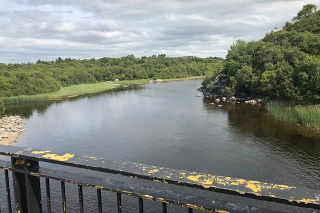
About halfway between Castlebar and Ballina is a wild
romantic district, in which Lough Conn and Lough Cullen
unite by a narrow sound, over which is a stone bridge of
one arch. Within this district, which is called the Pontoon,
the river Deel and several smaller streams flow into Lough
Conn, which discharges its superfluous waters into Lough
Cullen, into which also flow several large streams, of which
the chief is the river Moy. When these tributary streams Pontoon Bridge at Lough Conn, County Mayo, Ireland,
are swollen by mountain torrents, the Moy, which is the from 'scenery and Antiquities of Ireland' by William Henry
Bartlett
only outlet, is insufficient to carry off the redundant waters, which are forced back into Lough Conn.
The road here winding round the lake presents a succession of highly picturesque and romantic
scenery. On a rock overhanging the lake is a rocking-stone nicely poised, and at the bridge leading
from this parish to that of Kilbelfad Lord Bingham has erected a very commodious inn. Here is also a
constabulary police barrack, in which is stationed a constabulary police force.
Extract from Samuel Lewis’ 1837 Topographical Survey of Mayo
While local residents will likely be the primary users of the walking and cycling amenity, the presence of a
trail in this most scenic location will attract visitors to the area. It is recognised that while the
sporting/recreational aspect of trails and greenways will most likely appeal to the ‘Great Escapers’ target
market - those seeking an ‘escape’ from busy lifestyles to relax enjoy outdoor activity - a Knockmore/
Pontoon trail will appeal to the ‘Culturally Curious’ – those travelling to new places to explore landscapes,
history, and culture. have new experience. Visitors choose destinations based on the quality and extent of
the product available in the area, what they can do, see, and experience. Trails and greenways offer the
means of enhancing their experience by providing a safe and relaxing route through an area along which
the local story can be told through interpretation, access to heritage, scenic viewing points, etc. The
packaging and presenting of the local story can lead to a memorable visitor experience.
Local Attractions and Amenities
In the wider Knockmore/ Pontoon area, i.e.Feasibility Study for the Lough Conn/ Lough Cullen Recreational Trail Network Other basic services and amenities that can be found closer to Knockmore/ Pontoon, i.e.
Feasibility Study for the Lough Conn/ Lough Cullen Recreational Trail Network
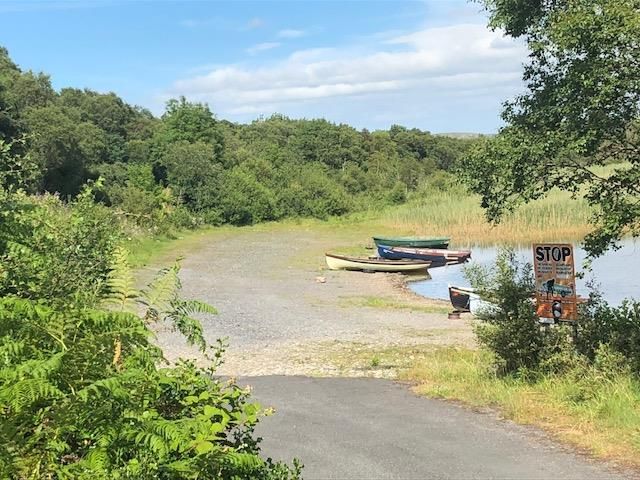
Access to the loughs is available at designated locations including three along the route of the proposed
trail: Knockmore Bay, Schoolhouse Bay, and Pontoon. Shelters for anglers have been erected around the
two loughs, but none are in the immediate vicinity of the proposed trail. Boat hire was previously available
from Healy’s Hotel and the Pontoon Bridge Hotel, formerly site of a fly fishing and angling school, and is
generally available in the wider region. Fish and tackle shops can be found in Foxford and other local areas.
Angling guides and tours are available from the following providers:
• Padraigh Kelly, Cloghans, Ballina • Vinney O’Boyle, Knockfree, Ballina • Judd Ruan, Ballina
• Tiernan Brothers, Foxford • Cloonamoyne Fishery, Castlehill • Ken Hall, Foxford
• Foxford Lodge, Foxford • Gerry Murphy, Crossmolina • Kenny Sloan, Foxford
Local Walking and Cycling Trails
In addition to the short Knockmore Trail
amenity located along the shores of
Knockmore Bay, other trails existing in the
immediate vicinity of Knockmore/ Pontoon
include the Foxford Loop walks, four
interconnecting rural and urban walks
totaling more than 50km in length. One of
these walks, the 33km Foxford Way Loop, is
considered to be one of the finest walks in
County Mayo. It provides views of the Ox
Mountains to the northeast and Nephin to
the west. Along its route walkers will
encounter bogs, mountains, lakes, rivers, and
a wealth of natural and archaeological
heritage. The trailhead is located in Foxford Foxford Loop Walks Map (source: www.mayowalks.ie)
and the estimated time it takes to complete
the route is 7-8 hours.
The Foxford Way, not to be confused with the Foxford Way Loop, is an established long-distance
waymarked route 86km in length. It is comprised of both on and off-road sections extending through the
Ox Mountains and around Lough Cullen and including a section that passes through Pontoon. Traversing
lakeshore and mountain areas, the highest peak on the Foxford Way, is in the Ox Mountains, is 360m. The
13Feasibility Study for the Lough Conn/ Lough Cullen Recreational Trail Network
Foxford Way complements the 124km Mayo section of the
National Waymarked Western Way trail, which is 200km in
length and links with the 78km Sligo Way to the north and to
Oughterard, County Galway to the south. The existing trail
route provides an opportunity to create new linkages with the
proposed Lough Conn/ Lough Cullen trail and other trails being
presently being considered for the region by Mayo and Sligo
County Councils.
Located approximately 13km south of Pontoon, at Turlough, is
the 8.8km Castlebar Greenway connecting Castlebar to
Turlough Park House, home to the National Museum of Ireland
- Country Life and the 36,000 objects held in the Irish Folklife
Collection. The Museum is one of the region’s most important
visitor attractions with more than 100,000 visitors annually. The cycling/walking trail is directly linked to
local sporting and recreational facilities, schools, residential Western Way Map (source: thewesternway.ie)
areas, and tourism accommodation and was constructed at a cost of almost €1.5million with National Cycle
Network funding and matching funds and labour costs provided by Mayo County Council.
Local Recreational Amenities
Drummin Wood is a Coillte forest recreation area
located at the northern shore of Lough Cullen, along
the route of the R318 Foxford to Pontoon road (as
depicted at right). A walking and bathing amenity
popular with local residents, Drummin Wood
contains approximately four kilometres of scenic
woodland walking trail through coniferous and
broadleaf forest. It also provides access to lakeside
beaches with parking and picnic and seating facilities.
The Foxford Way passes through the north eastern
end of the forest and on to Pontoon.
The forest features in the title of a poem ‘Drummin
Woods’ by the local Foxford poet and playwright
Frederick Robert Higgins, a student of William Butler
Yeats and member of the Board of the Abbey Theatre.
14Feasibility Study for the Lough Conn/ Lough Cullen Recreational Trail Network
Drummin Wood
As bare as a salley on the autumn waters
After red moonrise,
And a bright as the eye of a hunting otter
While the salmon lies,
She comes in the quiet of unseen dewfall-
Lightly, quietly avoiding the dewfall,
Into the wood she flies.
Ah, I fear she will frighten the little red foxes
From their ferny lair,
And the squirrel out on the juicy branches,
Sniffing the wholesome air;
But she lightly treads as if treading on blossoms-
The dead trees are bursting again in blossoms,
As she is stepping there.
O, I would we could wander while the blue stars glimmer
Through the salmon's abode;
O, to quietly wander where the fruitful hazels
Bear each unripe load
Above the rocks by the blue lake waters-
Lovers wandering down by the waters
On a shining sandy road.
Frederick Robert Higgins (1896 –1941)
Walking Festivals and Clubs
Established in 1967, the four-day Castlebar Walking Festival (www.castlebar4dayswalks.com) occurs
annually each summer and is Ireland’s oldest such walking event. It attracts more than 800 walkers from
around the world to the region to take part in organised walks and activities. The Foxford Walking Festival,
organised by the Foxford Ramblers Walking Club, has taken place in the locality in recent years. Other
walking clubs in the general vicinity include the North West Mayo Hillwalkers, Ox Mountain Ramblers,
Westport Hillwalking and Mountaineering Club, and Galway Mayo Institute of Technology Mountaineering
Club, all of which are registered with the Mountaineering Council of Ireland as is the Foxford Ramblers
Walking Club. Walking and cycling tour operators in the region include the following:
• Slainte Tours, Ballina • Croagh Patrick Walking Tours, Westport • Electric Escapes, Westport
• Trek West Tours, • Tourism Pure Walking Holidays, Castlebar • Paddle and Pedal, Ballina
Foxford
• Wild Nephin Walking, • Walking West Ireland Hillwalking Tours • Rachels Irish Adventures,
Keenagh Beg Lahardane Ballina
15Feasibility Study for the Lough Conn/ Lough Cullen Recreational Trail Network
There are numerous cycling clubs and providers in the wider Knockmore/ Pontoon area, to include:
• Ballina Cycling Club • Castlebar Cycling Club • Swinford Cycling Club
• Hopkins Bike Hire, Ballina • Ballycastle Bike Hire • Chaisil Lodge, Ballycastle
• Killala Bike Hire • Paddle and Pedal Ballina
Planned Developments for the Region
Mayo County Council’s long term plans for walking in
the County, in keeping with its stated aim of being the
‘walking capital of Ireland’, envisage having 200km of
greenways so as to establish/ reinforce its reputation
as a destination of choice for cyclists. The Council’s
recently presented Proposed County Greenway Plan
identifies future greenway projects for the County
including the development of a linear greenway from
Louisburgh to Foxford, via Achill Sound, Bellmullet,
Killala. This will have the effect of linking the
County’s two largest settlements, Castlebar and
Ballina, via Pontoon as shown in the Strategic
Greenway Network map at right. Greenway loops are also proposed for seven towns (Charlestown,
Swinford, Kiltimagh, Knock, Ballyhaunis, Claremorris, Ballinrobe). Towards this goal, the Council is currently
planning the development of 8km of walking and cycling trails as an initial stage of the Clew Bay Trail, a
19km greenway from Westport to Louisburgh. To be in the best position to secure funding for projects, the
Council will prioritise projects to ensure that they are well planned and ‘shovel ready’ in terms of delivery
in the short-term.
In 2013 the National Parks and Wildlife Service (NPWS) and Coillte signed a joint agreement designating
more than 11,000 hectares of Ballycroy National Park and the adjacent Coillte-owned Nephin Forest as
‘Wild Nephin’, Irelands first wilderness/wild area. With Mayo County Council, a key project stakeholder,
Coillte and the NPWS are progressing plans to develop improved access to and public enjoyment of the
Nephin/ Ballycroy National Park area. In August 2018, funding of €2.1m for a new 56km cycleway through
Wild Nephin Ballycroy National Park was announced. Supported by Failte Ireland funding, the cycleway will
eventually link the Park to the Great Western Greenway and on to Ballycastle. Longer term plans envision
the development of dedicated cycling and walking routes between Nephin and the Ox Mountains, and the
developing Mountain Biking Centre at Coolaney, County Sligo, via the Western and Sligo Ways, as depicted
in the map of the proposed inter-county ‘Timber’/ ‘Wilderness’ Trail below.
16Feasibility Study for the Lough Conn/ Lough Cullen Recreational Trail Network
Funding of €145,000 was announced in 2016
for the development of a Foxford Blueway
linking the town of Foxford to Knockmore
Bay via the River Moy and Lough Cullen. The
proposed Blueway project would entail
new/upgraded landing points along the
shoreline and connect with existing and new
angling, boating, walking, and cycling
amenities. The project is currently being
planned by Mayo County Council (trail map
depicted at right).
17Feasibility Study for the Lough Conn/ Lough Cullen Recreational Trail Network
3. Population of Catchment Area1
Demographics/ Population Statistics of Catchment Area2
For the purposes of this study, the catchment area for the walk has been recorded as including the electoral
divisions of Mount Falcon, Sraheen, Pontoon and Toomore. These electoral divisions have been used to
generate the demographic/ population profile in this chapter and are illustrated on the map below.
Immediate catchment area
For the purposes of this study, the immediate catchment area for the project has been recorded as including
the electoral divisions of Mount Falcon, Sraheen, Pontoon and Toomore. These electoral divisions have
been used for the purposes of the demographic/ population profile in this chapter and are illustrated on
the map below.
1 All demographic statistics are sourced from the CSO’s Census 2016
2 All demographic statistics are sourced from the CSO’s Census 2016 Small Area Population Statistics (SAPS)
18Feasibility Study for the Lough Conn/ Lough Cullen Recreational Trail Network
Expanded catchment area
The promoters have requested the expansion of the catchment area to include the urban areas of Castlebar
and Ballina. These have been incorporated into the population statistics discussed in the remainder of this
section.
Population
Total Population, Census 2016
The overall population of the immediate catchment area, as defined by specific electoral division
boundaries, is 4,481 persons; increased to 17,208 when the urban areas of Castlebar and Ballina which
reflect the wider catchment area are included.
Population
Ma l e, 8,400
Fema le, 8,808
Male Female
County Mayo has a total population of 130,638, which represents a very slight decrease on the population
recorded in 2011. In comparison, regionally, i.e. the North and West planning area, the percentage increase
in population was 1%, while it was 4% nationally.
Age profile of population, Census 2016
The population of the area is predominantly, almost half, between 19 and 59 years of age, though with
sizeable numbers of dependents, 24%, aged 18 years of age and under, and 25% aged 60 years and over.
19Feasibility Study for the Lough Conn/ Lough Cullen Recreational Trail Network
Percentage of population between 0-18 years of age, Census 2016
Age profile 0 to 4 5 to 9 10 to 14 15 to 18 Total
years years years years
Boys 596 510 543 388 2,037
Girls 542 539 532 400 2,013
Total 1,138 1,049 1,075 788 4,050
% of Total Population 7% 6% 6% 5% 24%
Years 0 1 2 3 4 5 6 7 8 9 10 11 12 13 14 15 16 17 18 Total
Boys 141 121 116 96 122 117 106 104 96 87 119 104 111 106 103 101 96 93 98 2,037
Girls 109 105 108 115 105 100 104 111 123 101 101 99 119 109 104 89 104 106 101 2,013
Total 250 226 224 211 227 217 210 215 219 188 220 203 230 215 207 190 200 199 199 4,050
% Pop. 1% 1% 1% 1% 1% 1% 1% 1% 1% 1% 1% 1% 1% 1% 1% 1% 1% 1% 1% 24%
Percentage of population over between 19-59 years of age, Census 2016
Age profile 19-24 25-29 30-34 35-39 40-44 45-49 50-54 55-59 Total
years years years years years years years years
Male 557 505 624 591 551 494 540 538 4,400
Female 588 544 653 568 558 514 566 529 4,520
Total 1,145 1,049 1,277 1,159 1,109 1,008 1,106 1,067 8,920
% of Total Population 7% 6% 7% 7% 6% 6% 6% 6% 52%
Percentage of population over 60 years of age, Census 2016
Age profile 60-64 65-69 70-74 75-80 80-84 85+ Total
years years years years years years
Male 512 514 342 280 187 128 1,963
Female 538 478 387 322 265 285 2,275
Total 1,050 992 729 602 452 413 4,238
% of Total Population 6% 6% 4% 3% 3% 2% 25%
Size of households, Census 2016
Size of households 1 2 3 4 5 6 7 8+ Total
person person person person person person person person
Number of households 2,425 2,057 1,021 790 368 176 39 42 6,918
Number of people 2,425 4,114 3,063 3,160 1,840 1,056 273 368 16,299
% of total people 15% 25% 19% 19% 11% 6% 2% 2% 100%
The total number of people recorded above is very slightly different to the total number living in the area –
this is likely due to the number of people who may not have stated the size of the household above.
20Feasibility Study for the Lough Conn/ Lough Cullen Recreational Trail Network
Family Cycle, Census 2016
The Family Cycle measures the number of families categorised according to separate criteria based upon
different stages, e.g. pre-family, pre-school, empty nest, etc. Areas with a high number of families in the
pre-school stages would generally require the greatest level of supports regarding childcare services.
Family cycle Pre- Empty Retired Pre- Early Pre- Adolescent Adult Total
family nest school school adolescent
Number of families 347 491 486 426 404 464 516 1,016 4,150
Number of people 694 982 972 1,344 1,478 1,827 2,093 3,333 12,723
% of families 8% 12% 12% 10% 10% 11% 12% 24% 100%
The average percentage of families in a pre-school cycle in the area is similar to that of the overall County.
Disability, Census 2016
17% of persons described themselves are “persons with a disability”, which is higher than the national rate
of 13.5%.
Male Female Total
Persons with a Disability 1,441 1,559 3,000
% of Total Population 17% 18% 17%
General Health, Census 2016
51% of persons in the area described their health as being “very good”, compared to 58% nationally.
Very good Good Fair Bad Very bad Not stated Total
Population by general health 8,798 5,399 2,009 389 72 541 17,208
Percentage of households 51% 31% 12% 2% 0.4% 3% 100%
Number of carers, Census 2016
Carers Male Female Total
No. of carers 269 432 701
% of Total Population 3% 5% 4%
Means of travel to work, school or college, Census 2016
Means of travel On Bike Bus Train, Motorbike Car Car Van Other Work N/A Total
foot or DART or / scooter driver pass. at
coach LUAS home
Work 1,185 83 55 14 8 3,368 299 403 16 189 262 5,882
School or college 937 26 660 10 0 163 1,492 16 2 7 146 3,459
Total 2,122 109 715 24 8 3,531 1,791 419 18 196 408 9,341
21Feasibility Study for the Lough Conn/ Lough Cullen Recreational Trail Network
Travel time to work, school or college, Census 2016
Time Under 1/4 hour 1/2 hour 3/4 hour 1 hour - 1 1/2 Not Total
15 - under - under - under 1 under 1 hours stated
mins 1/2 hour 3/4 hour hour 1/2 hours and over
Journey time 4,692 2,382 828 187 232 139 685 9,145
% of Total 51% 26% 9% 2% 3% 2% 7% 100%
Time of leaving for work, school or college aged 5+
Population aged 5+ by Before 06.30- 07.01- 07.31- 08.01- 08.31- 09.01- After N/A Total
leaving time 06.30 07.00 07.30 08.00 08.30 09.00 09.30 09.30
Number of persons 348 461 523 914 1,333 2,786 1,321 1,005 454 9,145
% of Total 4% 5% 6% 10% 15% 30% 14% 11% 5% 100%
Employment by sector
Sector Agriculture, Building & Manufacturing Commerce Transport Public Profess. Other Total
forestry construction industries and trade and admin. services
and fishing communic.
Male 127 246 539 723 192 169 437 643 3,076
Female 17 14 271 718 65 172 1,009 666 2,932
Total 144 260 810 1,441 257 341 1,446 1,309 6,008
Access to internet
Access Broadband Other No Not stated Total
Households with internet 4,163 653 1,914 173 6,903
Percentage of Households 60% 9% 28% 3% 100%
The population of the immediate catchment area for the trail is estimated to be almost 4,500 persons, 48%
of who are between 19 and 59 years of age. There are more than 1,200 families living in the area, accounting
for more than 3,800 residents, 1,966 of who are adolescent or younger. When Castlebar and Ballina are
included, the total catchment population rises to 17,208 with 52% aged between 19 and 59 years. There
are 4,150 families in this extended catchment area, representing almost 13,000 local residents of which
4,054 are adolescent or younger. In general, the health of 51% of the population (8,798) is “very good”,
less than the national average of 58%. Of those traveling to work, school, or college, 9,341 person, more
than half, 5,322, do so by car and only 10persons, travel to work (3,368) and to school or college (163) by
car, and only 2,231 travel by foot or cycle.
Given the size of the catchment area population, and the lack of similar facilities in the immediate area,
there is considerable justification for developing local walking and cycling trail infrastructure. More so, as
almost 4% of the wider catchment area population were born 2008-2010, the specific period when the birth
rate across Ireland and Europe ‘peaked’, there is a need to ensure that this and future generations have
access to healthy recreational experiences and are encouraged to have healthy lifestyles.
22Feasibility Study for the Lough Conn/ Lough Cullen Recreational Trail Network
4. Project Cost
Based upon the preliminary costs estimate of €159,700 per kilometre as provided by Mayo County Council
representatives, the projected total cost for the entire 9km trail is approximately €1,437,300. There are
several funding options open to the promoters, depending upon how the project is progressed, i.e. staged
development, etc., and each of these will have different requirements. A summary of some of the main
funding options is provided in the following section.
Department of Transport Tourism and Sport Greenway Strategy
Funding
As previously noted, the Department launched its new Greenway Strategy in July 2018 and announced €53
million for greenway development for the period 2019-2021. Applications from Local Authorities and State
bodies are invited, however priority will be accorded to national (>100km) and regional (>20km) routes,
though shorter trails will be considered where they are in excess of 20km and/or are ‘regarded as Strategic
in nature’, i.e. the provide the potential to link with or extend existing greenways.
Department of Rural and Community Development Outdoor
Recreation Scheme
A total of €12 million in funding was available under the Outdoor Recreation Scheme in 2018 for developing
and maintaining outdoor amenities such as greenways, blueways and cycleways. Under Measure 2 of the
Scheme, a maximum of €200,000 can be applied for Medium Scale Repair/Upgrade and New Trail
Development, and a maximum of €500,000 under Measure 3, Large Scale Repair/Upgrade and New Strategy
Trail Development. Collaborative applications from Local Authorities and other project partners, e.g.
community groups, etc., are invited and there is a requirement for a minimum of 20% match funding.
Department of Rural and Community Development Town and Village
Enhancement Scheme
The purpose of the Town and Village Scheme is to increase the attractiveness of towns or villages, enhance
their environment and amenities, and to promote the potential for tourism. Applications up to a maximum
of €100,000 are accepted, however projects up to €200,000 will be considered where a strong case can be
made demonstrating exceptionally strong economic benefit to a town and/or its outlying areas.
Collaborative applications from Local Authorities and other project partners, e.g. community groups, etc.,
are invited and there is a requirement for a minimum of 20% match funding.
23You can also read