Federal Triangle Heritage Trail - Assessment Study January 2010
←
→
Page content transcription
If your browser does not render page correctly, please read the page content below
Federal Triangle Heritage Trail
                     Assessment Study
                     January 2010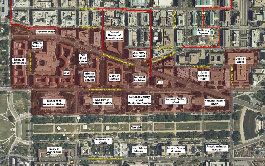
FEDERAL TRIANGLE HERITAGE TRAIL ASSESSMENT STUDY

2
NATIONAL CAPITAL PLANNING COMMISSION

Federal Triangle Heritage Trail
                Assessment Study
                January 2010

               Table of Contents
                               I. Overview             . . . . . . . . . . . . . . . . . . . . . . . . . . . . . . . . . . . . .1

                               II. Study Area                . . . . . . . . . . . . . . . . . . . . . . . . . . . . . . . . . .2

                               III. Background                   . . . . . . . . . . . . . . . . . . . . . . . . . . . . . . . .3

                               IV. Assessment Study Development . . . . . . . . . . . . .5

                               V. Possible Trail Route and Topics . . . . . . . . . . . . . . . . . . .6

                               VI. Implementation Timeline . . . . . . . . . . . . . . . . . . . . . .12

                               VII. Cost Estimate                . . . . . . . . . . . . . . . . . . . . . . . . . . . . . . .15

                               VIII. Planning Considerations                        . . . . . . . . . . . . . . . . . . . . .17

                               IX. Conclusions             . . . . . . . . . . . . . . . . . . . . . . . . . . . . . . . . . .21

                               APPENDIX A:
                                    STAKEHOLDER MEETING AND FIELD SURVEY NOTES . . . . . . . . . . . . . .22

                               APPENDIX B:
                                    POTENTIAL RESOURCES IDENTIFIED DURING STAKEHOLDER MEETINGS . . . . . .45

                               APPENDIX C:
                                     ACKNOWLEDGEMENTS . . . . . . . . . . . . . . . . . . . . . . . . . . . . . . . . . . . . .47

                                                                                                                                    CONTENTS
NATIONAL CAPITAL PLANNING COMMISSION
I. Overview
In September 2008, the National Capital Planning Commission (NCPC) partnered with Cultural Tourism DC
(CTDC), a local not-for-profit that specializes in the development of Neighborhood Heritage Trails within
Washington, DC, to work together to evaluate the feasibility of developing a heritage trail for the Federal
Triangle. This self-guided walking tour would highlight the art, architecture, history, commemoration, and
governmental functions within the Federal Triangle, with reference to the uses of the land that predate the
federal installations.
The purpose of this report is to provide a preliminary look at the research, outreach, collaboration, and
resources that will be necessary to design and implement a Federal Triangle heritage trail. It will be used
to garner federal and local support for the project, identify potential funding sources, and inform future
planning. When complete, the Federal Triangle heritage trail will satisfy a long-held desire of the federal
and local governments, as well as city residents, to put on display an area of Washington that has strong
local and national significance, and to better connect the National Mall to downtown Washington.
This report includes the following information:
A general description of heritage trails
The purpose and process for developing this assessment study
A series of possible stories that could be featured along the Federal Triangle heritage trail
A suggested timeline and preliminary cost estimate for implementing the Federal Triangle heritage trail
A collection of planning considerations that should be addressed during design and implementation
Conclusion and next steps
1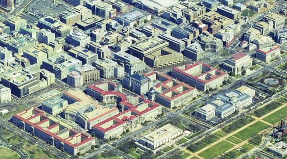
FEDERAL TRIANGLE HERITAGE TRAIL ASSESSMENT STUDY
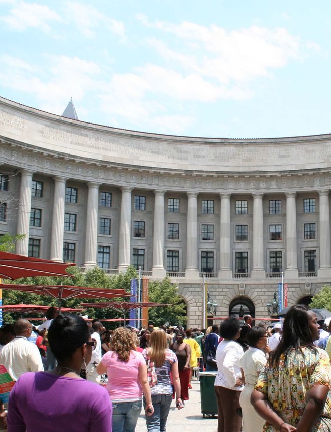
II. Study Area
The study area boundary that was used to prepare this report is consistent with the Federal Triangle
precinct of the recently adopted Monumental Core Framework Plan. This boundary encompasses the area
that is most commonly regarded as the Federal Triangle, as well as the areas immediately north of
Pennsylvania Avenue, NW, and south of Constitution Avenue, NW. The use of this study area to design a
Federal Triangle heritage trail is important for several reasons. First, by taking a 360-degree view of the
areas that immediately surround the Federal Triangle, the heritage trail will be able to convey how the
evolution of this federal precinct has influenced the surrounding neighborhood. This will also expand the
realm of content that is available for inclusion in the heritage trail, such as the history of the Federal
Bureau of Investigation, the historical uses of the Ellipse, the development of Freedom Plaza, the story of
the National Gallery of Art, and the growth of the Smithsonian Institution.
In addition, public spaces such as John Marshall Park, the National Gallery of Art Sculpture Garden, and
the U.S. Navy Memorial can be incorporated into the heritage trail route to provide users a place to relax,
and take in the monumental scale of the Federal Triangle from a distance. Finally, extending the study
area boundary to the north and south will also provide an opportunity to facilitate north-south pedestrian
connections between downtown and the National Mall by integrating the new Federal Triangle heritage trail
with the city’s existing system of Neighborhood Heritage Trails.
2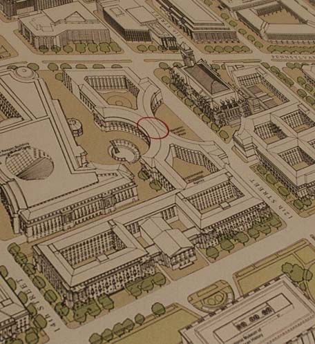
NATIONAL CAPITAL PLANNING COMMISSION

III. Background
The idea of a self-guided tour through the
Federal Triangle that would link downtown and
the National Mall was originally conceived in the
1982 Federal Triangle Master Plan, a product of
the General Services Administration (GSA).
According to this plan, the “Federal Walk,” as it
was called then, would educate visitors on the
historic significance, architectural treasures, and
governmental functions of the Federal Triangle.
The 1988 Federal Triangle Master Plan update
reinforces this idea, and states that “this walk
would be a series of attractions, or destinations that taken as a whole would provide a picture of the
Triangle’s richness and variety, yet when taken individually would provide a number of important points of
interest.” GSA further acknowledged the importance of implementing the Federal Walk when, despite the
growing concern for security in the federal workplace, it preserved this idea in its report “Urban Design
Guidelines for Physical Perimeter and Entrance Security: An Overlay to the Master Plan for the Federal
Triangle.” Most recently, the notion of implementing a self-guided walking tour through the Federal
Triangle was included in the Monumental Core Framework Plan: Connecting New Destinations to the
National Mall, prepared by the National Capital Planning Commission (NCPC) and the U.S. Commission of
Fine Arts (CFA). This plan not only recognizes the value of such a tour in showcasing the rich cultural,
social, and governmental history of this area of the nation’s capital, it also seeks to maximize its potential
to improve connections between the National Mall, the Federal Triangle, and downtown Washington, DC.

                                                                                                                         3
FEDERAL TRIANGLE HERITAGE TRAIL ASSESSMENT STUDY

               DISTRICT OF COLUMBIA NEIGHBORHOOD HERITAGE TRAILS

               When complete, the District of Columbia’s Neighborhood Heritage
               Trails system will be a collection of 17 self-guided walking trails in all
               eight of the city’s wards. Though relatively new, they have already
               become a city “brand” thanks to their distinctive design, consistent
               presentation, depth of research, and accessibility by the general
               public. The trails embrace the new social history, combining recent
               memory, as developed through extensive oral history interviewing,
               with more formal historical research. As such they represent the
               cutting edge in public historical interpretation. The result is a
               dynamic, story-telling approach to bringing history to the general
               public. In 2009, the Council of the District of Columbia designated
               the Neighborhood Heritage Trails system as the city’s “Official
               Walking Trails.”

               Each Neighborhood Heritage Trail averages 18 signs and is accompanied by a free guidebook summarizing
               the trail’s information. Signs typically have about 250 words of text, plus eight to ten images with captions.
               Thus, the history presented is brief and to the point, enhanced by the “thousand words” contained within
               each image. Typically each sign will present a primary and a secondary story. Heritage Trail signs are
               interpretive, and fabricated for a minimum ten-year lifespan. Therefore, they are not appropriate for
               displaying tourist information that is subject to frequent changes. The current design of the standard
               Neighborhood Heritage Trail sign is a component of the District’s citywide wayfinding signage system that
               was approved by the U.S. Commission of Fine Arts.

               The guidebooks are published in English and Spanish, and are designed to be distributed free to the
               public at businesses and institutions along the route as an incentive for walkers to patronize these
               establishments. The guidebooks reproduce some of the photographs used along the trail, and also add
               bibliographical information, notes on participants who developed the trail, and a list of other trails and
               their locations.

                                              The process of creating a heritage trail begins with story sharing and
                                              gathering of oral histories, extends through documentary and photographic
                                              research and expert reviews, and ends with design and installation of the
                                              signs. For each of the existing DC Neighborhood Heritage Trails, this process
                                              has typically taken 2.5 years. This has allowed for significant public input,
                                              thorough research, permitting, fabrication, and installation.

                                              Like the city’s existing Heritage Trails, the intended purpose of the Federal
                                              Triangle heritage trail is not simply to be a collection of factual markers, but
                                              rather a collection of stories and dynamic historic images that convey the
                                              social history of the neighborhood. With this approach the heritage trail will
                                              better engage viewers who search for relevant associations as they are
                                              entertained and educated.

                                              4
NATIONAL CAPITAL PLANNING COMMISSION

IV. Assessment Study Development
To assemble this report, NCPC and CTDC convened meetings with representatives from each of the federal
agencies that are currently located within the Federal Triangle. Representatives from local government
agencies such as the District Department of Transportation, District of Columbia Office of Planning, and
the District of Columbia State Historic Preservation Office also participated. The meetings focused on
three key questions:
         What stories could be told along a Federal Triangle Heritage Trail?
         Where within the area’s public space could these stories be told?
         What resources are available to help tell these stories?

In addition to meeting with interested federal and local agencies, NCPC and CTDC staff visited the Federal
Triangle to gain a familiarity with the study area and its relationship with its surroundings; get a sense of
the area’s accessibility and take a visual inventory of its cultural, recreational, and commercial assets; and
to identify areas that may be appropriate for a heritage trail sign. Additional background research was
conducted in order to inform the meeting participants and identify possible heritage trail content. The
following is a list of the federal and local agencies that participated:

  Advisory Council on Historic Preservation (ACHP)
  Department of Commerce (Commerce)
  Department of Justice (DOJ)
  District Department of Transportation (DDOT)
  District of Columbia Office of Planning (DCOP)
  District of Columbia State Historic Preservation Office (DC SHPO)
  Federal Bureau of Investigation (FBI)
  Federal Trade Commission (FTC)
  General Services Administration (GSA)
  National Archives and Records Administration (NARA)
  National Gallery of Art (NGA)
  National Park Service (NPS)
  Smithsonian Institution (SI)
  United States Commission of Fine Arts (CFA)

                                                                                                                        5
FEDERAL TRIANGLE HERITAGE TRAIL ASSESSMENT STUDY
V. Possible Trail Route and Topics
The creation of the Federal Triangle heritage trail is an opportunity to educate residents, workers, and visitors on
the area’s diverse cultural and social assets. By highlighting these assets the heritage trail will invite visitors to
explore the Federal Triangle, and use the area’s public spaces to reflect on what they’ve learned. At the same
time, the heritage trail can serve to better connect this federal precinct to the rest of the city by opening new
passages for pedestrian circulation, making public spaces more accessible, and reducing the monumentality of
the area at the pedestrian level by providing a familiar system of wayfinding signage.
The success of the Federal Triangle heritage trail will depend on the ability to effectively and concisely
communicate the area’s rich, multi-faceted history. It should demonstrate that the Federal Triangle is not just a
set of grand buildings, but it is home to important functions of the federal and local governments carried out by
dedicated public servants. In describing the area’s development history leading up to the monumental buildings
we see today, the trail should discuss the influence this acreage had on the surrounding areas, and on the
overall development of the city of Washington as both the nation’s capital and a familiar, American city.
By inviting tourists to expand their visit to the National Mall, and by offering a pleasant and healthful
walk for those who work in the area, the heritage trail will animate the many public areas of the
Federal Triangle. By linking to the city’s existing system of Neighborhood Heritage Trails, it will
encourage tourists to appreciate the rest of the city, bring more revenue to local government and
businesses by increasing pedestrian traffic, and aid workers and nearby residents in the full
enjoyment of downtown Washington. Moreover it will improve east-west connections within the
Federal Triangle, and facilitate north-south pedestrian circulation between the downtown, Federal
Triangle, National Mall, and Southwest Washington.
Heritage trail topics, and possible sign locations, that appear in the outline below are reflective of the ideas that
were generated during the government stakeholder meetings, and take into consideration lessons learned over
time from the development of the city’s existing Neighborhood Heritage Trails. For example, a very important
factor to the success of a heritage trail is its relationship to existing modes of public transportation, and in
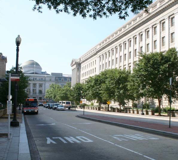
particular Metrorail. Therefore, the possible sign locations identified below take advantage of the Federal
Triangle’s namesake Metrorail station, located near 12th Street, NW and Pennsylvania Avenue, NW, and the
Archives-Navy Memorial-Penn Quarter Metrorail station located near 7th Street, NW and Pennsylvania Avenue,
NW. Other considerations that need to be taken into account include the distance between heritage trail signs;
the length of the trail and the time it takes to complete the walking tour; the number of stories told on each sign;
and the relevance of the information on a particular sign to its surroundings.
6NATIONAL CAPITAL PLANNING COMMISSION
The information presented below is in no way a comprehensive or fully resolved set of heritage trail topics and
possible sign locations, and all titles are for discussion purposes only. The true purpose of this information is to
provide a foundation upon which the future efforts to design and implement the Federal Triangle heritage trail
can rest. These efforts will undoubtedly require additional research and outreach in partnership with federal and
local agencies, current and retired public servants, and of course the general public. The outreach effort will be
useful when developing the heritage trail; it will help to uncover individual stories that may resonate on a very
personal level for some visitors, while eliciting a new-found respect from others.
7FEDERAL TRIANGLE HERITAGE TRAIL ASSESSMENT STUDY
Sign 1 Grandeur for the People
POSSIBLE LOCATION 7th Street, NW and Pennsylvania Avenue, NW
(Archives-Navy Memorial-Penn Quarter Metrorail station)
TOPICS The impetus behind the construction of the Federal Triangle and
the role of the City Beautiful Movement
1901 McMillan Plan and the creation of the
U.S. Commission of Fine Arts
The Public Buildings program, Charles Moore, and others
combined with contemporary political realities:
competition between American-style democracy and totalitarianism
The symbolic significance of the Federal Triangle and the
United States’ role as a world power.
Sign 2 On The Record
POSSIBLE LOCATION Pennsylvania Avenue, NW (between 7th Street, NW and 9th Street, NW)
TOPICS The National Archives
The plan for the Federal Triangle, siting of specific buildings,
and relationship to the L’Enfant Plan
John Joseph Earley and his polychrome concrete mosaic at the
Department of Justice
The location of the former Center Market
Sign 3 G-Men and G-Women
POSSIBLE LOCATION Pennsylvania Avenue, NW and 9th Street, NW
TOPICS The history and mission of the Federal Bureau of Investigation (FBI)
J. Edgar Hoover
The FBI Building’s “new brutalism” architectural style
FBI Building site prior to construction including
Native American artifacts found during excavation
Sign 4 And Justice for All
POSSIBLE LOCATION Pennsylvania Avenue, NW (between 9th Street, NW and 10th Street, NW)
TOPICS The Justice Department’s role in American life
Fighting crime and especially desegregating American life
and promoting civil rights;
Segregation and desegregation in the Federal workplace
Robert Kennedy, Francis Biddle, Elliot Ness
Sign 5 Paying for a Civilized Society
POSSIBLE LOCATION Pennsylvania Avenue, NW and 10th Street, NW
TOPICS The history and mission of the Internal Revenue Service (IRS)
What our tax dollars buy
8NATIONAL CAPITAL PLANNING COMMISSION
Sign 6 Preserving the Past
POSSIBLE LOCATION Pennsylvania Avenue, NW and 11th Street, NW
TOPICS The Old Post Office, the unfinished hemicycle,
and the birth of the historic preservation movement
The view from the Old Post Office Tower
History of the Old Post Office tower bells
Sign 7 Keeping It Green
POSSIBLE LOCATION Pennsylvania Avenue, NW and 12th Street, NW
TOPICS The history and mission of the Environmental Protection Agency (EPA)
The ornate and dramatic façades, arcades, and porticos of the
Ariel Rios Building
Sign 8 On the Cutting Edge
POSSIBLE LOCATION 12th Street, NW (between Pennsylvania Avenue, NW and
Constitution Avenue, NW - Federal Triangle Metrorail station)
TOPICS State-of-the-art building design in the 1930s, including central air
conditioning, courtyards for natural light and air, piped-in
steam heating.
Works Progress Administration (WPA) murals and mosaics
Publicly accessible WPA murals and mosaics located in
Ben Franklin Station Post Office
Sign 9 Appointed Rounds
POSSIBLE LOCATION Ariel Rios Courtyard (Benjamin Franklin Circle)
TOPICS Story of the U.S. Postal Service
Sign 10 An Enclave Remade
POSSIBLE LOCATION Pennsylvania Avenue, NW and 13th Street, NW (Moynihan Place)
TOPICS Pennsylvania Avenue Development Corporation (PADC)
(Moynihan Place)
The role of John F. Kennedy in remaking the avenue.
Freedom Plaza
Reagan Building
“Hooker’s Division” and the sex trade that predated the
Federal Triangle.
Sign 11 Whose City Is This?
POSSIBLE LOCATION Pennsylvania Avenue, NW and 14th Street, NW
TOPICS John A. Wilson Building and how the District of Columbia is governed
The changing role of automobiles in American life and its impact
on the design of the Federal Triangle
Streetcars along Pennsylvania Avenue
The growth of the federal workforce during WWI and WWII
The consolidation of the federal workforce
9FEDERAL TRIANGLE HERITAGE TRAIL ASSESSMENT STUDY
Sign 12 Open for Business
POSSIBLE LOCATION Pennsylvania Avenue, NW and 15th Street, NW
TOPICS History and mission of the Department of Commerce
Story of the British watching the White House burn from
Mrs. Suter’s Tavern in 1814.
The area’s history as an entertainment quarter: theaters,
Bull Run Cyclorama, Harvey’s Oyster Bar
The Federal Triangle in film and television.
Sign 13 And That’s Where the President Lives
POSSIBLE LOCATION 15th Street, NW and Constitution Avenue, NW
TOPICS The White House and the Ellipse.
Historic use of the Ellipse (commercial, recreational, etc)
Sign 14 Waterworks
POSSIBLE LOCATION 14th Street, NW and Constitution Avenue, NW
TOPICS National Aquarium in the Department of Commerce
Washington Canal and Tiber Creek
Flooding in the Federal Triangle, including the great flood of 1889
Sign 15 The Nation’s Attic
POSSIBLE LOCATION Constitution Avenue, NW (between 13th Street, NW
and 14th Street, NW)
TOPICS James Smithson’s bequest to the United States and the
birth of the Smithsonian Institution
Story of the Museum of American History
Mellon Auditorium, site of the first Selective
Service “Draft” of 1940
Sign 16 Vistas
POSSIBLE LOCATION Constitution Avenue, NW and 12th Street, NW
TOPICS The wide streets and avenues of the L’Enfant Plan
12th Street as a gateway into the city and views
through the Federal Triangle.
Challenges of building Metrorail
Sign 17 What Style Is It?
POSSIBLE LOCATION 10th Street, NW and Constitution Avenue, NW
TOPICS The building styles of the Federal Triangle, from Beaux-Arts to
Art Deco and back.
Story of the Museum of Natural History
10NATIONAL CAPITAL PLANNING COMMISSION
Sign 18 The “public walk”
POSSIBLE LOCATION 9th Street, NW and Constitution Avenue, NW
TOPICS The National Mall as planned by Pierre L’Enfant, developed
by Andrew Jackson Downing, and re-made by the McMillan Plan.
Sign 19 Washington Goes to War
POSSIBLE LOCATION Constitution Avenue, NW (between 7th Street, NW and 9th Street, NW)
TOPICS World War I and II temporary buildings on the Mall
Washington grows in response to crises
Story of John Russell Pope and the craftsmen and tradesmen who
built the National Archives building
Sign 20 The Golden Rule
POSSIBLE LOCATION 4th Street, NW and Pennsylvania Avenue, NW
TOPICS History and mission of the Federal Trade Commission (FTC), the need
for a federal watchdog to stop unfair and unsafe business practices
Story of how the FTC came to occupy the Federal Triangle’s last structure.
The simplified design of the FTC Building (Apex Building)
The immigrants of 4 1/2 St., and relocating Chinatown
Sign 21 Dollar-a-Year Man
POSSIBLE LOCATION Pennsylvania Avenue, NW and Constitution Avenue, NW
TOPICS Andrew Mellon and the story of the National Gallery.
Patriotic philanthropy and dollar-a-year men.
Sign 22 America’s Main Street
POSSIBLE LOCATION 4th Street, NW and C Street, NW
TOPICS Government Girls
Frances Perkins, first female cabinet member, Secretary of Labor
The Story of John Marshall
Sign 23 Muscular Art
POSSIBLE LOCATION Pennsylvania Avenue, NW and 6th Street, NW
TOPICS The Apex Building sculptures and the art that generally pervades the
Federal Triangle building façades
The train stations (and other businesses) that occupied the Mall.
President Garfield’s assassination inside the Baltimore and
Potomac train station
Walking the avenue: Presidential inaugural walks, protests and celebrations.
Looking at racial progress, from slave pens along Pennsylvania Avenue to
President Obama’s inauguration, racial riots of 1919
The Bonus March: confronting and dispersing the Bonus Army protestors
11FEDERAL TRIANGLE HERITAGE TRAIL ASSESSMENT STUDY
VI. Implementation Timeline
This implementation timeline is for discussion purposes only and is based largely on CTDC’s experience on
designing other DC Neighborhood Heritage Trails. For the purposes of this assessment, it has been
assumed that design of the Federal Triangle heritage trail would begin in February 2010, and would
continue for a period of approximately 22 months. An underlying assumption of this timeline is that the
design of the Federal Triangle heritage trail signs will be consistent with the city’s existing Neighborhood
Heritage Trails in order to facilitate better pedestrian connections between downtown and the National
Mall through the use of a consistent set of wayfinding signage.
The Content and Design component includes those project activities that deal
with public outreach, development of heritage trail content, and design of the
The suggested implementation timeline sign panels.
is broken into four components:
The Agency Coordination component outlines the schedule of federal and
Content and design
local coordination and review that will be necessary to implement the project.
Agency coordination
Sign fabrication Finally, the Sign Fabrication, and Permitting and Installation components
Permitting/installation describe the process of manufacturing and installing the actual heritage trail
signs. The timeline is broken into components in order to show what project
activities can take place concurrently, and to help identify areas where the
project can be expedited once design of the trail begins.
DATE CONTENT AND DESIGN AGENCY COORDINATION SIGN FABRICATION PERMITTING AND INSTALLATION
2/2010 Begin public and agency Confirm stakeholder representatives and
stakeholder meetings to identify form a Federal Triangle heritage trail
conceptual trail route and topics, working group.
and oral history subjects.
Initiate discussions with applicable
agencies on opportunities to provide
increased public accessibility to Federal
Triangle buildings.
Initiate discussions with GSA, NPS, and
DDOT on public space restrictions and
permitting processes within the study area,
particularly along Pennsylvania Avenue.
Milestone NCPC and CFA review of conceptual heritage trail route and topics.
6/2010
6/2010 Stakeholders review and comment on
conceptual trail route and topics, as well as
list of identified oral history subjects.
12NATIONAL CAPITAL PLANNING COMMISSION
DATE CONTENT AND DESIGN AGENCY COORDINATION SIGN FABRICATION PERMITTING AND INSTALLATION
7/2010 Prepare request to District of Present conceptual trail route and topics to
Columbia Heritage Trails Advisory District of Columbia Heritage Trails
Committee for inclusion in the Advisory Committee for review and
city’s Neighborhood Heritage Trail approval
program
7/2010 (**assuming approval by the Initiation of Section 106 consultation and
District of Columbia Heritage National Environmental Policy Act (NEPA)
Trails Advisory Committee **) processes (if required).
Conceptual trail route and topics
are expanded through in-depth
research, oral interviews, and
researching historical
photographs.
Preparation of draft trail script
and captions.
12/2010 Stakeholders review and comment on first
draft of trail script, sign captions, and
photo selections.
1/2011 Final edits/changes to draft trail Stakeholders review and comment on final
script, sign captions, and photo draft of trail script, sign captions, and
selections. photo selections.
Completion of Section 106 consultation
and National Environmental Policy Act
(NEPA) processes (if required).
Milestone NCPC and CFA review preliminary and final trail route and topics.
2/2011
3/2011 Route/sign locations are Initiate process for identifying Initiate process for identifying
declared final contractor(s) for sign panel and contractor(s) for sign installation.
hardware fabrication.
Begin permitting process with federal
and local agencies.
3/2011 Begin layout of trail sign panels
3/2011 Begin work on audio tour.
4/2011 Begin writing companion
guidebook (English version)
4/2011 Stakeholders review and comment on
design and layout of sign panels
5/2011 Stakeholders review and comment on
guidebook (English version)
6/2011 Guidebook copy sent to Spanish Select sign panel and hardware
translator fabricator(s)
Milestone Final design of trail signs sent to fabricator
6/2011
13FEDERAL TRIANGLE HERITAGE TRAIL ASSESSMENT STUDY
DATE CONTENT AND DESIGN AGENCY COORDINATION SIGN FABRICATION PERMITTING AND INSTALLATION
7/2011 Stakeholders review and comment on Complete all necessary permitting processes.
guidebook (Spanish version)
Select contractor(s) for installation of trail
signs
7/2011 Audio tour submitted to stakeholders for
review and comment
Milestone Audio tour is completed
8/2011
7/2011 Guidebooks sent to designer
7/2011 Design of guidebook submitted to
stakeholders for review and comment
8/2011 Guidebooks sent to printer Stakeholders arrange guidebook Trail signs received and inspected.
distribution
Milestone Guidebooks delivered
8/2011
9/2011 Signs installed
Milestone Final trail dedication event
10/2011
14NATIONAL CAPITAL PLANNING COMMISSION
VII. Cost Estimate
The following estimate reflects the typical costs associated with the planning, design and installation of a
23-sign heritage trail in the Federal Triangle. As with the suggested implementation timeline, this cost
estimate is based on the past experiences of CTDC in designing and implementing the existing system of
DC Neighborhood Heritage Trails. All costs are based on 2009 pricing and are subject to change based on
federal government procurement procedures, and when implementation of the Federal Triangle heritage
trail actually begins.
Phase 1 through Application
5 months (2/2010 - 7/2010)
Hold stakeholder meetings; compile data, write application, appear
before Heritage Trail Advisory Committee for review and approval.
Meetings & Writing Application
Staff $27,387
Supplies and Travel $230
Subtotal $27,617
Phase II Development
7 months (7/2010 - 2/2011)
Complete research, work with stakeholders on building access
questions, compile historic images, edit manuscript, submit for
stakeholders’ review, and prepare final manuscript.
Staff $112,000
Supplies and Travel $380
Photo Acquisition and Permissions $3,100
Subtotal $ 115,480
Phase III Design
6 months (3/2011 - 8/2011)
Design signs, submit for stakeholders’ comments, write and design booklets
Staff $47,883
Translator $3,082
Supplies and Travel $161
Cartography $500
Design - English book $10,914
Design - Spanish book $8,025
Design - Signs $29,532
Printing - English Book $ 8,000
Printing Spanish Book $5,350
Subtotal $113,447
Audio 5 months (3/2011 - 8/2011)
Staff $40,308
Audio producer $32,100
Subtotal $72,408
continued on next page
15FEDERAL TRIANGLE HERITAGE TRAIL ASSESSMENT STUDY
Phase IV Fabrication and Installation
4 months (6/2011 - 10/2011)
Manage fabrication including all proofs and oversee installation.
This does not include permitting costs if applicable.
Fabrication
Staff $13,829
Supplies and Travel $275
Fabrication of standard HT signs $125,350
Subtotal $139,454
Installation
Staff $6,641
Supplies and Travel $25
Installation of standard HT signs $31,050
Subtotal $37,716
Total Cost
$ 506,122
16NATIONAL CAPITAL PLANNING COMMISSION
VIII. Planning Considerations
The Federal Triangle heritage trail will be the first of hopefully a series of trails that traverse the areas
traditionally known as federal precincts which surround the National Mall. As a project located on federal
land, the project will be subject to review by federal agencies. Furthermore, since the heritage trail signs
will be located within public space, the project will most likely require review by the federal and local
authorities that have jurisdiction over this space. This section briefly describes the various public review
and/or regulatory approvals required for the project, as well as some important design issues that should
be considered in the development of the heritage trail.
FEDERAL AND LOCAL REVIEW
National Capital Planning Commission
As the central planning agency for the federal government, NCPC has review authority over federal projects
in the national capital region. Since the signs associated with the Federal Triangle heritage trail would be
located on land owned by the federal government, this project would be subject to NCPC review and
approval. NCPC review involves the determination that the proposed action is consistent with the policies
of the Comprehensive Plan for the National Capital: Federal Elements, the Monumental Core Framework
Plan, and other relevant plans and policies. In addition, as a federal agency any NCPC action is subject to
the requirements of Section 106 of the National Historic Preservation Act, and the National Environmental
Policy Act (NEPA). Therefore, depending on the scope and location of the project, the entity charged with
leading the implementation of the heritage trail may be required to initiate and complete Section 106
consultation with the District of Columbia State Historic Preservation Office, and prepare the necessary
environmental documentation in accordance with NEPA.
U.S. Commission of Fine Arts
The U.S. Commission of Fine Arts (CFA) reviews the design of public buildings, commemorative works, and
parks in the District of Columbia, among other responsibilities. In addition, the Shipstead-Luce Act
authorizes CFA to review the designs of private developments on land abutting or across from important
federal properties including Pennsylvania Avenue between the White House and the U.S. Capitol.
Therefore, the implementation of the Federal Triangle heritage trail would be subject to review by CFA.
District Department of Transportation Public Space Committee
The District Department of Transportation has management and oversight responsibility for the use and
occupancy of the public space. Public space is defined as all the publicly owned property between the property
lines on a street and includes, but is not limited to, the roadway, tree spaces, sidewalks and alleys. Depending
upon the type and location of the request to use or occupy the public space, the request may require the review
of DDOT’s Public Space Committee (PSC). The Public Space Committee meets monthly to review and render a
decision on a variety of types of permit applications, and provides a recommendation to DDOT on whether an
application can be approved without having an adverse impact on the use and safety of the public space. Since
the signs associated with the Federal Triangle heritage trail will be located within the public right-of-way, they will
most likely require the review of the DDOT Public Space Committee.
17FEDERAL TRIANGLE HERITAGE TRAIL ASSESSMENT STUDY
District of Columbia Neighborhood Heritage Trails Advisory Committee
The DC Neighborhood Heritage Trails Advisory Committee reviews and approves all applications for the
production of new DC Neighborhood Heritage Trails. The panel is chaired by DDOT, and consists of
representatives from the Federal Highway Administration, DC Parks and Recreation, DC Office of Planning,
DC State Historic Preservation Office, Historical Society of Washington, DC, and the Washington
Metropolitan Area Transit Authority. Therefore, prior to any extensive research and outreach, the Federal
Triangle heritage trail concept will first need to be approved by the advisory committee. To render a
decision, the advisory committee applies a set of criteria to determine whether a proposal is eligible to be
included in the city’s existing system of Neighborhood Heritage Trails.
Public Involvement and Interagency Collaboration
In addition to the public participation that is necessary during the federal and local review process, the
actual development of the Federal Triangle heritage trail should be based on extensive public input. As a
federal office enclave, the Federal Triangle is not a “neighborhood” in the traditional sense of the word.
However, this should not be interpreted to mean that the area lacks in strong personal connections. To a
large degree, the development history of the Federal Triangle is a physical embodiment of the story of the
United States, and therefore an opportunity to reach audiences on a national level. To ensure that
residents, workers, and visitors can personally relate to stories told on the
heritage trail, efforts should be made to collect stories from as diverse a
population as possible during the research phase of the project. The
heritage trail is also an opportunity to educate the public on the role of
government in everyday life, especially on the history and mission of the
government agencies within the Federal Triangle. Therefore, current and
retired government employees, historians, and other interested stakeholders
should work closely with those putting together the heritage trail in order to
assemble a clear and consistent message.
Building and Courtyard Access
There are opportunities and constraints to providing access to
the Federal Triangle’s courtyards and buildings. Several of the
buildings contain significant cultural resources such as murals,
sculptures, and interior architectural elements not found in any
other building in the nation. For instance, the lobbies, hallways
and library in the Department of Justice headquarters showcase
over fifty murals painted by prominent American artists 7Mall,
the east-west connections through the Federal Triangle pose a
bigger challenge, partly due to the size of the buildings, the
absence of east-west streets, and the limited pedestrian paths.
The buildings in the Federal Triangle are primarily office buildings,
where employees conduct the daily work of these federal agencies.
18NATIONAL CAPITAL PLANNING COMMISSION
As such, workplace disruption should be minimized, and work environments must be secured, if public access is
allowed in these buildings. Guided public tours could be limited to the lobbies, hallways, and communal areas
without disturbing the privacy of federal employees at work and the overall operations of the various agencies.
Individual building tours could also be coordinated, and occur on a weekly or monthly basis during times when
workplace disruption and security concerns would be minimal. Information about these tours could be included
in the heritage trail guidebooks, or on various websites.
Pedestrian Linkages
A key objective of the Federal Triangle heritage trail is to improve
pedestrian connections between the downtown, National Mall, the
Southwest neighborhood, and the waterfront. A heritage trail in the
Federal Triangle that connects to the existing “Civil War to Civil Rights”
Neighborhood Heritage Trail to the north would be an important first
step towards achieving this objective. Linking these trails would provide
pedestrians a seamless network of safe, walkable connections that have
the added amenity of offering cultural enrichment.
Although sidewalks and walking paths currently exist within the Federal
Triangle, they may not possess adequate amenities for wayfinding,
safety, and comfort of pedestrians. The large-scale buildings cut off
sightlines and long distance views of destinations, making wayfinding a
challenge. Therefore, pedestrian safety and accessibility must be a key
consideration during the heritage trail’s research and planning stages.
Taking the necessary precautions to ensure pedestrian safety and
comfort will greatly increase the trail’s success in conveying information.
This includes:
Making sure crosswalks are in good working order including paving and signal timers
Making sure sidewalks are well-maintained
Minimizing the number of street crossings
Maintaining proximity to places that have seating, shade, and refreshments
Locating trail signs far enough away from curbs and busy intersections
Locating trail signs so as not to impede pedestrian flow along the sidewalk
Locating trail signs in areas that are well lit, have multiple points of access, and are
not screened by walls or vegetation.
Therefore, it is recommended that implementation of the Federal Triangle heritage trail be carried out
simultaneously with any streetscape improvements found to be necessary.
In addition to improving pedestrian connections, the heritage trail has the potential to increase access and
visitation to local businesses and destinations. To maximize this potential, the design of the heritage trail
should take into consideration the amenities that exist within the study area. For example, in the vicinity of
the Federal Triangle are major destinations and attractions such as public plazas, museums, theaters,
cafes, and restaurants that can be visually linked to the heritage trail through the strategic placement of
the trail’s interpretive signs near primary building entryways and gateway locations.
19FEDERAL TRIANGLE HERITAGE TRAIL ASSESSMENT STUDY
Transit Linkages
To increase visibility and access, heritage trail signs should be strategically located near bus stops and
Metrorail stations. Several Metrobus routes service the Federal Triangle, making the precinct highly accessible
by transit from other parts of the District and the region. Fifteen to twenty Metrobus routes serve the Federal
Triangle via Pennsylvania Avenue, NW, and another five Metrobus routes run along Constitution Avenue, NW.
Seventh Street, NW, which is at the eastern end of the Federal
Triangle, is also a major route for buses, with 15 different routes.
The “Convention Center-SW Waterfront” route of the DC Circulator
also provides a premium transit service to the Federal Triangle. Most
significantly as it applies to the location of heritage trail signs, the
Federal Triangle enjoys excellent Metrorail access with its own
namesake station located at the Ariel Rios Building (EPA
Headquarters) on 12th Street, NW, and three other stations within
four blocks: National Archives-Navy Memorial-Penn Quarter, Gallery
Place-Chinatown, and Metro Center stations.
Sign Design and Location
The Federal Triangle heritage trail has the potential to be a unifying element of the
streetscape along Pennsylvania Avenue, Constitution Avenue, and throughout the Federal
Triangle public spaces. It also has the potential to improve pedestrian connections by
seamlessly integrating with the District of Columbia’s existing Neighborhood Heritage
Trails program. The city’s system is designed to clearly differentiate individual trails and
their neighborhoods by the use of distinctive colors, titles, and repeating pictorial
elements (icons). In other words, each trail has a unique color palette, title, and icon.
Thus trail users can clearly see which trail they are following at any given moment even
when they are in site of another neighborhood trail. Despite these variations in color and
content, the consistent sign design and graphic layout of the city’s system also provides
a level of familiarity to trail users. This has resulted in pedestrians increasingly relying
upon the signs to safely guide them along a particular trail, and into other parts of the
city. In order to maintain that level of reliability and confidence, the Federal Triangle
heritage trail should following the same process for developing signs, graphic and
narrative style, and trail content set by the city’s Neighborhood Heritage Trails
program. Finally, design and location of the Federal Triangle heritage trail signs
should be coordinated with developed design guidelines and ongoing plans for other
public amenities such as streetscape improvement plans and transit center plans.
This will aid in reducing visual clutter along the streetscape, and help facilitate
smooth pedestrian circulation.
Sign and Trail Maintenance
Prior to construction, a well-thought-out sign and trail maintenance strategy should be
assembled in order to ensure the trail’s long-term ability to educate and safely guide users.
This strategy should identify the agencies or organizations that would be responsible for the
physical maintenance of the signs, including carrying out repairs and cleaning when
necessary. It should identify and secure the sources of funding for maintenance of the signs,
and for continued publication of the free trail guidebooks. Finally, it should contain a timeline
for updating sign content and renovating sign panels.
20NATIONAL CAPITAL PLANNING COMMISSION
IX. Conclusions
Implementation of the Federal Triangle heritage trail would not only advance the goals of the recently
adopted Monumental Core Framework Plan, it would fulfill a long-standing desire to highlight the Federal
Triangle’s rich collection of cultural assets and improve connections throughout this part of the city.
Through a series of well-designed, strategically-located interpretive signs, the heritage trail will describe the
history and mission of the government agencies located in the Federal Triangle, document the evolution of
the area’s physical and social make-up, and showcase the diverse array of artistic and architectural assets
that currently exist. With such a diverse range of educational offerings, the Federal Triangle, as stated in
the Monumental Core Framework Plan, could become a museum of many parts, comparable to the
institutions on the National Mall.
As much as the heritage trail will serve to educate, it will also serve as an effective means of wayfinding,
and ultimately improve accessibility throughout the Federal Triangle by weaving together parks, plazas, and
public spaces along a flexible and easy-to-navigate trail. Through close coordination with government
agencies, the heritage trail can be implemented in a manner that provides some level of public access to
buildings and building courtyards, while balancing a secure and productive workplace. Access to building
courtyards will make the Federal Triangle more permeable by opening up new east-west passageways, and
encouraging pedestrians to explore new ways to traverse the area. Furthermore, by providing an amenity
that will likely result in pedestrians extending the length of their visit to the Federal Triangle, the heritage
trail will help to invigorate may of this area’s public spaces, and perhaps play an important role in a more
comprehensive program focused on enlivening these spaces through the use of ground-floor retail,
vending, concerts, building tours, and public art exhibits. Accessibility to the Federal Triangle will be further
enhanced by ensuring that the Federal Triangle heritage trail is seamlessly integrated with the city’s
existing system of Neighborhood Heritage Trails. In order to make this happen it is important that the
design, content, and placement of the heritage trail signs are consistent with the city’s system. This
consistency will allow pedestrians to have confidence in the trails to safely and reliably guide them, as well
as provide a consistent set of maps that pedestrians can use to navigate between downtown and the
National Mall.
21FEDERAL TRIANGLE HERITAGE TRAIL ASSESSMENT STUDY
APPENDIX A:
STAKEHOLDER MEETING AND FIELD SURVEY NOTES
FEDERAL WALK HERITAGE TRAIL
Stakeholder Meeting #1
Meeting Notes and Next Steps
Meeting location: National Capital
Planning Commission
Meeting date/time: January 28, 2009
MEETING AGENDA:
Background
Cultural Tourism DC (CTdc), the city’s agent for creating the District of Columbia Neighborhood Heritage
Trails, has been engaged to lead initial exploration of a Heritage Trail for the Federal Triangle. With the
working title of “Federal Walk,” this project will bring Heritage Trail methodologies to developing a series of
trail markers that present a self-guided walking tour of the Federal Triangle’s rich history, both as today’s
cluster of governmental workspaces, art, and architecture, and its precursor: the local neighborhood
between the Mall and Pennsylvania Avenue.
I. Introductions
Shane Dettman, Community Planner, NCPC
II. NCPC and CTdc roles
III. Overview of the District of Columbia Neighborhood Heritage Trails program
Jane Freundel Levey, Director of Heritage Programs, Cultural Tourism DC
IV. Timeline
VI. Stakeholders’ historical resources & level of involvement (including designated reviewers who
will commit to give feedback on trail materials as they develop)
VI. Questions / Discussion
Adjourn - 11:30 am
22NATIONAL CAPITAL PLANNING COMMISSION
Attendees:
Joel Porter - National Park Service (NPS)
Karen Beach - General Services Administration (GSA)
Bill Kane - GSA
Jane Freundel Levey - Cultural Tourism DC (CTdc)
Pat Wheeler (CTdc)
Bill Dowd - National Capital Planning Commission (NCPC)
Elizabeth Miller - NCPC
Stefanie Brown - NCPC
Kristi Tunstall - GSA
Shane Dettman of NCPC introduced the topic and had the attendees introduce themselves around the
table. He said that the idea for the Federal Walk dates from the mid-1980s, and is included in the current
National Capital Framework Plan, which NCPC and CFA are producing in coordination with several federal
and local partner agencies. The intention is to help move people through the Federal Triangle while
building appreciation for the structures and highlighting the cultural assets and the stories of the people.
Elizabeth Miller of NCPC noted that the Framework Plan calls for “site-specific strategies” to improve the
settings for new destinations around the Mall area and especially to improve the connections between the
Downtown, the Mall, and the waterfront. The Federal Walk can be a great way to “raise the profile” of the
Federal Triangle. It’s identified as a “near-term” initiative in the Framework Plan, and may be the first
project to come out of the Framework Plan.
Jane Levey of CTdc gave a PowerPoint presentation explaining how CTdc creates a District of Columbia
Neighborhood Heritage Trail, highlighting art and architecture, but focusing on people stories and
personifying history whenever they can. A Neighborhood Heritage Trail is a self-guided tour, and a
component of developing a heritage trail is building respect and pride in the neighborhood. Jane stated
that the current average cost to develop a trail is approximately $250,000, and the average
implementation time is two years (usually 6 months working with stakeholder groups). Other noteworthy
items that came out of the presentation include:
Access to public transportation is paramount to the success of a trail
All stories told on a Heritage Trail are linked to specific geographic locations
Maintenance of the trail signs is shared between CTdc and DDOT; DDOT funds replacements of signs
that are damaged by traffic, etc.
The typical elements of a sign are: title (theme and locator), “boilerplate” (summary,
acknowledgements and trail map), narrative, and illustrations
A finished sign contains about 250 words of narrative, not including captions
A primary consideration for CTdc is the safety and comfort of trail users (places to take a break,
restaurants, and other destinations)
DC Neighborhood Heritage Trails have been funded by DDOT, FHWA, and the Deputy Mayor for
Planning and Economic Development.
23FEDERAL TRIANGLE HERITAGE TRAIL ASSESSMENT STUDY
The presentation concluded by posing three basic questions: What are the stories that should be
told? Who can tell them/what are the resources? Where should they be told?
The ensuing discussion is summarized below:
It was stated that “the everyday strength of our government is a very important story to tell.”
Jane expressed the idea of “holding up the federal worker as the hero.”
Kristi Tunstall inquired if the “hero” needed to be a person and whether it could be an agency. She also
mentioned that long-time federal employees are retiring at a very fast rate and suggested we move quickly
to capture their stories.
Joel Porter asked whether CTdc currently had a way to measure the success of a heritage trail. Jane
replied that currently there is no “scientific” measurement but a crude measure can be made based on
the guidebooks that are made available at several venues.
It was asked approximately how many signs make up a heritage trail and whether there was formula for
figuring this out. Jane responded that typically a trail is about 1 - 1.5 miles in length, consists of 16 - 18
signs, and takes about 1.5 hours to complete.
Jane stated that one of the ideas CTdc is currently looking at is to include the walking miles and/or
something to do with the carbon footprint on the heritage trail signs.
Most of the buildings are off-limits to casual visitors (and even in some cases to visitors who seek access
through the security apparatus). NCPC and GSA will talk about access and routes through the buildings,
especially since the Triangle has wonderful courtyards that would be great to see. EPA even has a rain
garden inside its walls.
Bill Kane stated that the contrast between what used to exist in this area and what currently exists is a
unique element that could be highlighted.
Joel Porter asked “How can we weave together the different interpretive elements of the Federal Triangle
heritage trail and the future interpretative elements that are currently being looked at for the National Mall?”
Nancy Witherell, historic preservation officer, NCPC Urban Design and Plan Review Division, said that her
office and other NCPC resources could be put to work on gathering oral histories in consultation with CTdc
since CTdc doesn’t have the contract hours to begin that phase.
24NATIONAL CAPITAL PLANNING COMMISSION
Action items/follow-ups:
The next meeting will be held following the completion of the Framework Plan. Shane will work with committee members
to broaden participation, especially from CFA, NPS and GSA and the other affected agencies.
Attendees are asked to bring information on accessibility to their respective facilities. They are also asked to add to
the initial list of source materials and persons of interest to interview. Attendees are also asked to consider whether
the trail should look inward at the Triangle, or if it offers an opportunity to look at neighboring sites across the
boundaries, such as places on Pennsylvania Avenue, the Mall, etc. Finally attendees are asked to consider the
three questions posed by Jane at the end of her presentation as the basis for continuing discussion.
NCPC will set up a meeting with the CTdc and the National Park Service to discuss interpretation and
connections to the Mall.
NCPC will work with CTdc to discuss the project’s boundary
Topics
What did the Triangle look like when it was part of L’Enfant’s Plan? What elements of the plan were lost when
the Triangle was constructed?
What was the neighborhood like before the Triangle? How do we tell about brothels and taverns, enslaved
people, the role of the city canal and its deterioration into an open sewer?
City Beautiful Movement and the McMillan Commission: the distinction between the “white city” and the red
brick city.
Desire on the part of Congress and the Executive to use the capital city as a symbol of America’s new role as
a world power after the Spanish-American War (1898).
Also will be important to describe to tourists what the agencies actually do for U.S. citizens. This should be a
part of the effort to personify the federal workforce, to recognize the heroes of government and counteract the
nonstop vilifying of “Washington” by politicians and others.
Race, individuals, community, social / political, physical
Issues
Access to the courtyards and art inside the buildings - how to direct visitors if they will be permitted inside
Complementing any forthcoming NPS signage on the Mall
Keeping the system flexible enough to add other loops later, possibly doing interpretation on the Mall itself
Connecting the trail to existing Heritage Trails in Downtown and Southwest
Building consensus and attracting wide participation on the agency levels as well as among constituencies.
Other Questions that came up during the meeting
How do we want to brand “our neighborhood”?
How do you include the Mall without contradicting the NPS?
What is involved in updating the sign boards when it is time to replace them (10 years)?
What security issues will need to be overcome and how do we best address them (building and public space)
without compromising the effectiveness of the heritage trail in educating and making connections?
25FEDERAL TRIANGLE HERITAGE TRAIL ASSESSMENT STUDY
FEDERAL WALK HERITAGE TRAIL
Stakeholder Meeting #2
Meeting Notes and Next Steps
Meeting location: National Capital Planning Commission
Meeting date/time: May 27, 2009
MEETING AGENDA
I. Introductions (5min)
II. Project Overview (10 min)
III. Brief Summary of Meeting #1 (5 min)
IV. Stakeholder Input on Pre-Meeting Questions (60 min)
What stories should be told along the Heritage Trail?
What resources do you know of that will help us tell these stories?
Where within the public space in or near the Federal Triangle) should these stories be told?
VI. Brief Discussion on Building Access and Public Space (5 min)
Who should we contact in order to begin this discussion?
Who are the decision makers in determining whether or not to provide access?
What security and / or public space policies currently exist?
What land use / permitting issues need to be addressed?
What kind of access is provided today?
VI. Next Steps (5 min)
Preparation of meeting notes
Individual stakeholder meetings with CTdc and/or NCPC
Report outline
Report draft
Draft report / outline review
Meeting # 3 date and possible discussion topics
Adjourn - 2:30
Attendees:
John Robbins - National Gallery of Art (NGA)
Tom Nastich - National Archives
Joyce Tsepas - Office of Planning (OP)
Research Administration (NARA)
Chris Shaheen - OP
Michael Hussey - NARA
Bill Dowd - National Capital
Karen Beach - General Services Administration (GSA)
Planning Commission (NCPC)
Christine Ewing - GSA
Shane Dettman - NCPC
Kristi Tunstall - GSA
Elizabeth Miller - NCPC
Frank Giblin - GSA
Stefanie Brown - NCPC
Jane Freundel Levey - Cultural Tourism DC (CTdc)
26You can also read