MELAKA GLOBAL FUTURE CITIES PROGRAMME - Prosperity Fund
←
→
Page content transcription
If your browser does not render page correctly, please read the page content below
Prosperity Fund
GLOBAL FUTURE CITIES PROGRAMME

MELAKA
           CITY CONTEXT REPORT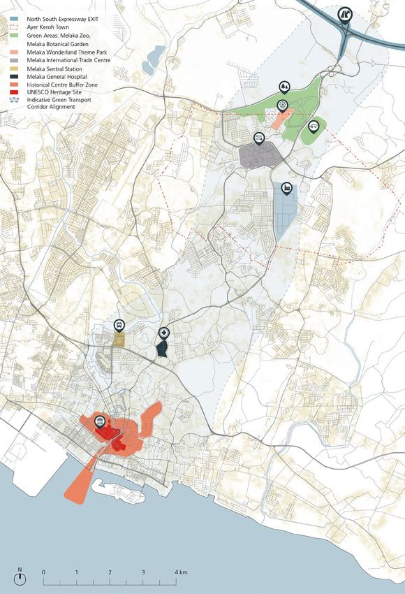
Prosperity Fund
GLOBAL FUTURE CITIES PROGRAMME

  MELAKA
           CITY CONTEXT REPORT
                    December 2018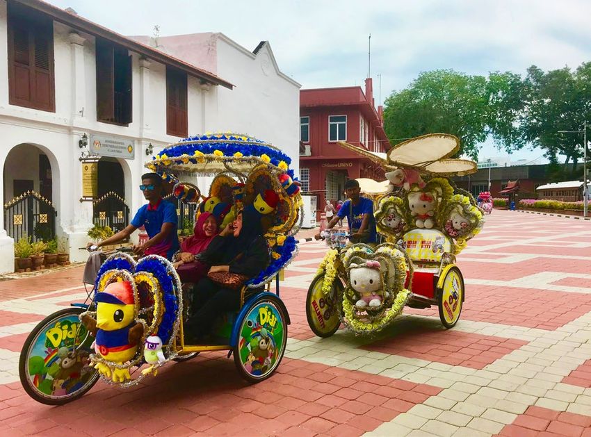
Global Future Cities Programme
MELAKA
City Context Report

UNITED NATIONS HUMAN SETTLEMENTS PROGRAMME
P.O. Box 30030, Nairobi 00100, Kenya
www.unhabitat.org

Funded by: United Kingdom Foreign and Commonwealth Office (UK FCO)
Lead executive agency: UN-Habitat: Urban Planning and Design Lab
Academic partner: International Growth Center (IGC)
Professional partner: United Kingdom Built Environment Advisory Group (UKBEAG).

Disclaimer
The designations employed and the presentation of material in this report do not imply the expression of any opinion
whatsoever on the part of the Secretariat of the United Nations concerning the legal status of any country, territory,
city or area or of its authorities, or concerning the delimitation of its frontiers or boundaries, or regarding its economic
system or degree of development. The analysis conclusions and recommendations of this publication do not necessarily
reflect the views of the United Nations Human Settlements Programme or its Governing Council or its member states.
Reference of this publication of any specific commercial products, brand names, processes, or services, or the use of
any trade, firm, or corporation name does not constitute endorsement, recommendation, or favouring by UN-Habitat
or its officers, nor does such a reference constitute an endorsement of UN-Habitat.

Acknowledgments

City context report coordinators (Melaka): Charlotte Mohn, Stephanie Gerretsen, Riccardo Maroso (UN-Habitat)

United Kingdom Foreign and Commonwealth Office (UK FCO)

Project Management 					Elizabeth Milsom
Kuala Lumpur Office						Carol Koh

United Nations Human Settlements Programme (UN-Habitat)

Project Coordination 						Laura Petrella
Project Manager      					Rogier van den Berg
Project Supervisors						Klas Groth, Naomi Hoogervorst

Local City Specialist						Syahriah Bachok, Mariana Mohamed Osman

Urban Planning and Design LAB
Niina Rinne, Jonathan Weaver, Sara Thabit, Gabriela Aguinaga, Dongni Niu, Riccardo Maroso, Charlotte Mohn,
Ban Edilbi, Jean-Noé Landry, Katherine Cashman, Princesse Samba, Yabework Kifetew, Nadia Mourid, Yumi Neder,
Stephanie Gerretsen, Shegufta Newaz, Helen Yu, Francesco Tonnarelli

International Growth Center (IGC)

Project Coordination 						Astrid Haas

Contributors
Priya Manwaring, Victoria Delbridge, Michael Blake, Oliver Harman, Shah Rukh, Sebastian Kriticos

United Kingdom Built Environment Advisory Group (UKBEAG)

Project Coordination and Strategic Advisor 			Peter Oborn
Project Lead							Adrian Mallesom
Contributor and City Visiting Expert 				Camilla Ween
CONTENTS

GLOBAL FUTURE CITIES PROGRAMME                                      4
  Introduction                                                      4
     About The Global Future Cities Programme
     Intervention Development and Validation
     The City Context Report
  Melaka                                                            9
     General Context
     Problem Statement
     Introduction to the Interventions

URBAN ANALYSIS                                                     12
  Spatial Analysis                                                 12
     Access to Melaka City
     Access and Mobility within Melaka City
     Urban Challenges
  Financial Analysis                                               18
     Financial Capacity
     Financing Mechanisms
  Legal Analysis                                                   19
     Urban Planning and Transport Governance Structure
     Legal Frameworks Relevant to the Interventions

INTERNATIONAL ALIGNMENT AND TECHNICAL RECOMMENDATIONS              22
   Potential Impact                                                22
      Short-term impact
      Medium-term impact
      Long-term Outcomes
   Contribution to Sustainable Urban Development                   24
      2030 Sustainable Development Goals
      New Urban Agenda Alignment
      Alignment To Cross-Cutting Issues And Programme Objectives
   Success Factors                                                 27
      Spatial Considerations
      Financial Considerations
      Legal Considerations

ENDNOTES                                                           32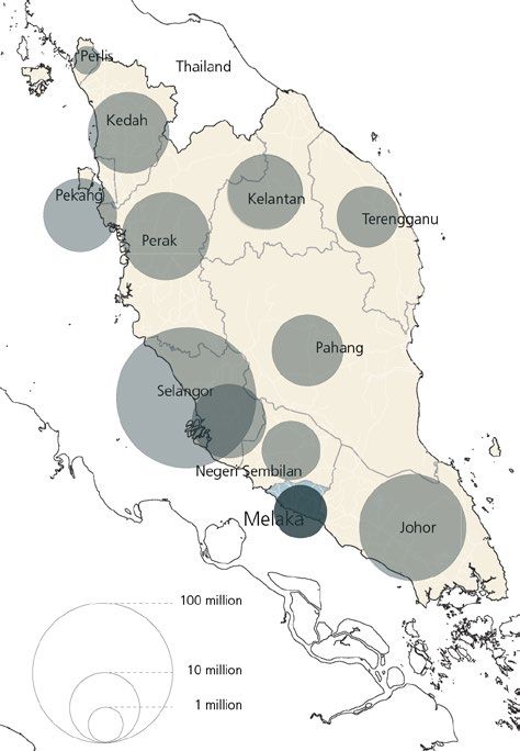
4   MELAKA - City Context Report

    GLOBAL                                                      and collectively provide further evidence for the overall
                                                                programme.

    FUTURE CITIES                                               The Programme builds upon a coherent series of
                                                                targeted interventions in 19 cities across 10 countries,
                                                                to support and encourage the adoption of a more

    PROGRAMME                                                   sustainable approach to urban development. In general,
                                                                the proposed interventions aim to challenge urban
                                                                sprawl and slum developments, thereby promoting more
                                                                dense, connected and inclusive cities that in combination
                                                                contribute to prosperity, achieving the Sustainable
                                                                Development Goals (SDGs) and implementing the New
    Introducti on                                               Urban Agenda (NUA).

                                                                The Global Future Cities Programme builds upon three
                                                                integrated pillars, that will address key barriers to
    ABOUT THE GLOBAL FUTURE CITIES PROGRAMME                    prosperity, in selected cities:

    In 2015, the UK government created a new Cross-             •   Urban planning – technical assistance for
    Government Prosperity Fund worth £1.3 billion from              spatial restructuring (Public space, Heritage
    2016-2021, in order to help promote economic growth             and urban renewal, Urban strategies and plans,
    in emerging economies. Its broad priorities include             Data systems for integrated urban planning);
    improving the business climate, competitiveness and         •   Transportation – technical assistance to
    operation of markets, energy and financial sector               support cities to develop integrated transport
    reform, and increasing the ability of governments to            systems (Multi-modal mobility strategies and
    tackle corruption.                                              plans, Data systems for multi-modal mobility);
                                                                •   Resilience – technical assistance to develop
    Emerging Economies still face considerable challenges           strategies to address the impact of climate
    such as uncontrolled urbanisation, climate change and           change and ensure development is sustainable
    high and persistent inequality which can lower long-            (Flood management plans and systems).
    term growth prospects. The Prosperity Fund supports
    the broad-based and inclusive growth needed to              In order to capitalize on the proposed interventions
    build prosperity and reduce poverty, but also make          and to ensure sustainability and impact in a longer-
    development overall more sustainable through the            term perspective, the programme has a strong focus on
    strengthening of Institutions and Improvement of the        technical support and institutional capacity development.
    global business environment.
                                                                In many of the interventions, there is a particular focus
    The Global Future Cities Programme (GFCP) is a specific     on the potential of embedding smart/digital technology
    component of the Prosperity Fund which aims to carry        and data analysis platforms in urban governance and
    out targeted interventions to encourage sustainable         management processes. Integrating smart technologies
    urban development and increase prosperity whilst            is recognized as an instrumental area that significantly
    alleviating high levels of urban poverty. The programme     can improve the efficiency in the provision of key
    will also create significant short and long-term business   infrastructure services, enhance urban resilience, support
    opportunities in growing markets, forecast to be regional   evidence-based plans and strategies and promote
    growth hubs, including for UK exporters who are world       integrated planning approaches across sectors.
    recognised leaders in urban innovation.
                                                                INTERVENTION DEVELOPMENT AND VALIDATION
    The overall strategy of the Global Future Cities
    Programme is to deliver the Programme in two phases;        Based on initial scoping studies and government-to-
    a strategic development phase (2018), followed by           government engagement carried out by UK FCO, the
    an implementation phase (2019-2021). UN-Habitat,            UN-Habitat team worked with partner local authorities
    in collaboration with the International Growth Centre       and wider stakeholders to corroborate their city
    (IGC) and the UK Built Environment Advisory Group           development strategies, and to confirm, enhance and
    (UKBEAG), has been mandated by the UK Foreign               develop the intervention proposals.
    and Commonwealth Office (UK FCO) to develop and
    undertake the strategic development phase. This in          In each city, a Local City Specialist, supported by the
    turn, will inform and shape the implementation phase,       national and regional country offices of UN-Habitat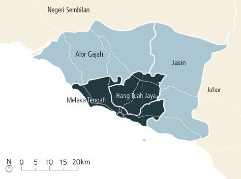
INTRODUCTION     5

and in liaison with the FCO local posts, took the             in a set of City Context Reports as well as an analysis of
lead in identifying stakeholders in a series of bilateral     the technical viability of the interventions. The analysis
meetings, interviews and focal group discussions. This        aimed at both informing the development of the Terms
has collectively gathered information and provided            of Reference and the future implementation phase of
more detailed knowledge and information on the City’s         the Programme.
visions and goals.
                                                              THE CITY CONTEXT REPORT
Based on this initial phase, a Charrette (planning
workshop) involved high-level decision-makers from            Objectives
the public and private sectors together with civil            A City Context Report is provided for each city of the
society representatives. This facilitated discussion on       Global Future Cities Programme. It serves as a tool to
the proposed and possible alternative interventions,          frame the proposed Programme interventions within
related individual interests, technical opportunities and     the characteristics and pre-conditions of each city.
constraints, as well as political objectives. The outcome
of the Charrette provided clarity on where stakeholders       The Report targets a variety of stakeholders in the
stand in relation to the strategic potential of the           Programme: administrators, city managers, policy
discussed projects and it allowed for the mobilisation        makers, legislators, private sector actors, donors, and
of support.                                                   local as well as international researchers and knowledge
                                                              generators. The Reports also provide UKFCO the
At the same time, the Charrette allowed for the technical     contextual setting of each proposed intervention, and
teams to proceed with the development of a Terms of           can in addition, be used by the Service Providers as an
Reference, outlining the specific scope and activities of     entry point for the implementation phase.
each intervention. A final Validation Workshop assured
consensus on the proposed projects and document’s             By addressing the specific challenges facing each city, the
endorsement by the authorities.                               Report illustrates how the interventions can work towards
                                                              inclusive prosperity and sustainable urban development.
Parallel to preparing the Terms of Reference, an              The benefits of each intervention, however, cannot be
evaluation of the interventions was initiated, aiming to      achieved without certain enabling conditions to ensure
address its feasibility within the local strategic context,   its success. Therefore, critical aspects for the delivery
identify potential impact on prosperity barriers and to       of the proposed interventions and its success from a
explore the optimal delivery models. This process resulted    long-term perspective are outlined. Using thematic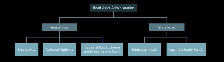
6   MELAKA - City Context Report

    best practices and evidence from global learnings and          can either facilitate or hinder the implementation and the
    research, contextualised recommendations are provided          long-term sustainability of the proposed interventions in
    on the conditions necessary for the intervention to be         transport, resilience and urban planning.
    viable and to reach a maximum impact.
                                                                   This framework follows UN-Habitat’s three-pronged
    Essentially, the City Context Report serves to ensure that     approach, recognising the three essential components
    all actors within the Global Futures Cities Programme          for a successful and sustainable urbanisation: 1. urban
    are aware of the specific conditions to be considered in       planning and design; 2. urban economy and municipal
    the delivery of the proposed interventions, on a case-by-      finance; 3. urban legislation, rules and regulations.
    case basis.
                                                                   Firstly, the spatial analysis describes the existing urban
    Set-up and Scope                                               context specific to the intervention. Urban mobility
    The first part of the City Context Report (General             systems, vulnerability of the built environment, spatial
    Overview) provides an overview of the Global Future            form and trends are considered as possible challenges in
    Cities Programme and introduces the city from the              urban management that the intervention can address.
    perspective of the urban challenge which the proposed
    intervention intends to address.                               Secondly, the financial analysis aims to identify the
                                                                   mechanisms in place by which the intervention could
    The second part of the Report (Urban Analysis) more            be sustainably financed in the long-run. This section
    critically and technically analyses a selection of factors     outlines the city’s municipal capacity, existing regional,
    which need to be considered or to be in place for              national and international financial ecosystem and
    the intervention to succeed, addressing its feasibility,       existing financing mechanisms at the municipal level.
    potential impact on prosperity barriers from a long-term
    perspective.                                                   Thirdly, from a legal perspective, the Report critically
                                                                   analyses how the intervention could be facilitated or
    The third part of the Report (International Alignment          challenged by the vision of the city and its governance
    and Technical Recommendations) presents short–and              hierarchy. Enablers and obstacles resulting from any
    mid-term expected outcomes as well as long-term                relevant legislation, as well as sectoral frameworks
    potential impacts. It further elaborates the contribution      (e.g. strategies, policies, planning frameworks and
    of the intervention to the achievement of the SDGs and         development plans, detailed plans of relevance) are also
    the implementation of the New Urban Agenda as well             described.
    as the programme objectives of the Prosperity Fund.
                                                                   This approach aims to offer implementing partners,
    As the City Context Report is tailored directly to             stakeholders and donors a general context of the city
    the Programme interventions, the analysis does not             and, with it, demonstrate the appropriateness of the
    aim to comprehensively present all aspects of urban            intervention from a spatial, financial and legal point of
    development. It does not elaborate on long term                view, while at the same time informing about potential
    planning and transformation strategies, the effectiveness      barriers and enablers for its implementation.
    of policy or urban legislation, nor the entire municipal
    financial system. As such, it also excludes urban policy       Potential Impact to the Program Objectives and the
    recommendations.                                               SDGs

    However, the Report has the scope to illustrate the            The Report also outlines the potential impact of the
    general capacity of the city for project delivery, and         interventions, based on the specific activities and
    in this regard, make recommendations to support                outputs proposed. Impact can arise from a complex
    implementation of the interventions and reaching set           interaction of context-specific factors, rather than as
    goals. The City Context Reports will be part of knowledge      result of a single action, which makes it difficult to
    management for the Programme to generate local                 empirically quantify longer-run effects that go beyond
    information and data on the cities as well as identify         the identification of program outputs. An empirical,
    gaps in knowledge, systems or governance.                      comprehensive impact assessment is therefore not part
                                                                   of the scope of this report.
    Methodology
                                                                   Nevertheless, the report outlines potential benefits
    Urban Analysis                                                 that are only achievable under certain preconditions
                                                                   and activities. Thereby, short-, medium- and long-term
    The City Context Report provides a general analysis of         outcomes are defined with reference to a project-cycle
    the spatial, financial and legal conditions in the city that   approach, which considers all the project phases from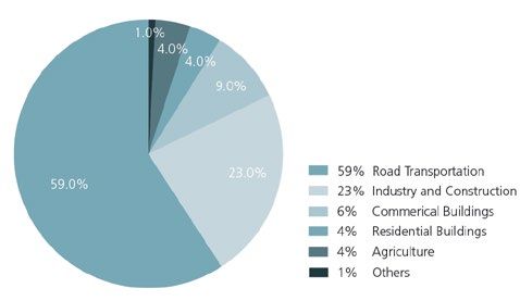
INTRODUCTION      7

                                                            The City Context Reports further connect potential
                                                            impacts to the Programme’s objectives, taking into
                                                            account also the Cross-cutting issues at the core of
                                                            UN-Habitat’s mandate from the UN General Assembly.
                                                            Consequently, the Programme’s objectives are
                                                            summarized into five principles:

                                                            •    Climate Change;
                                                            •    Gender Equality;
                                                            •    Human Rights;
                                                            •    Youth;
                                                            •    Sustainable and Inclusive Economic Growth.

                                                            Cross-cutting issues are addressed with explicit reference
                                                            to the 2030 Sustainable Development Goals (SDGs) and
                                                            the New Urban Agenda, in an attempt to ensure that
                                                            the proposed interventions are in line with the design,
                                                            implementation, review and success of the 2030 Agenda
                                                            for Sustainable Development. Consistent with UN-
                                                            Habitat’s mandate, the SDG 11 Sustainable Cities and
                                                            Communities is linked with the urban dimension of the
                                                            other 16 goals as an essential part of the localisation of the
                                                            SDGs. In this way, interventions can support localisation
                                                            processes, to support local ownership and ensure SDG
                                                            integration in sub-national strategies and plans.

                                                            Technical Recommendations and International Best
                                                            Practices

                                                            The interventions proposed in the various cities of the
                                                            Global Future Cities Programme were grouped into
                                                            clusters according to their thematic entry-point, as an
                                                            elaboration of the thematic pillars of Urban Planning,
                                                            Transport and Resilience.

                                                            These clusters are:

                                                            •    Public space
                                                            •    Heritage and urban renewal
Planning and Design through Building, to Operating and      •    Urban strategies and plans
Maintaining.                                                •    Data systems for integrated urban planning
                                                            •    Multi-modal mobility strategies and plans
Short-term outcomes are directly achieved through the       •    Data systems for multi-modal mobility
implementation of the technical assistance support,         •    Flood management plans and systems
within the 2-3 years scope of the Global Future Cities
Program.                                                    Combining the international experience in urban policy
                                                            and project implementation of UN-Habitat and the
Mid-term outcomes are only realised once the                leading academic research of IGC, each cluster was
intervention is executed through either capital             analysed to offer evidence-based recommendations for
investment, implementation of pilot projects or             a successful Implementation and a maximised impact
the actual enactment of legal documents, plans or           of the intervention. Specific reference was given to
masterplans, within a possible timeframe of 3 to 7 years.   implemented plans and international best practices.

The broader long-term impact of the interventions           The recommendations inform the Planning and Design
is linked to the sustainability of the interventions in a   phase which coincides with the timeframe of the Global
7-15 years timeframe and relates to the operation and       Future Cities Programme, and always aim for long-term
maintenance phase of the project cycle.                     sustainability of the interventions.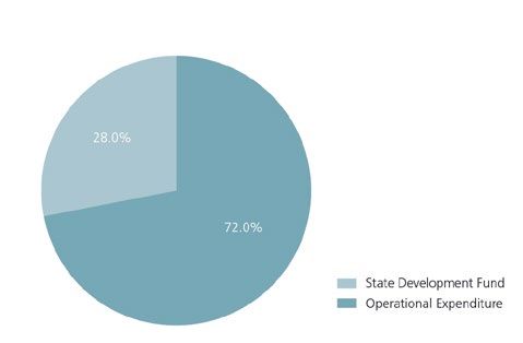
8 MELAKA - City Context Report
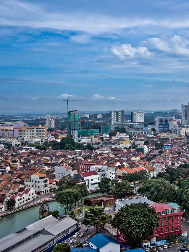
Fig. 1. Melaka Aerial View (Source: Flickr)INTRODUCTION 9
M el aka Strategically located on the Malaysian peninsula and
one of Malaysia’s oldest cities, Melaka was a prominent
historic trading post that eventually turned into a vibrant
GENERAL CONTEXT commercial centre. As a former linkage between the
Global East and West, Melaka became a multi-cultural
Melaka State is located on the southwestern coast of city, influenced by Indian, Chinese, and European
the Malaysian peninsula, facing the Straight of Melaka. culture, which manifested itself in the area’s unique
It lies between the capital, Kuala Lumpur, and Johor architecture. Melaka was established as a core historic
Bahru, which connects to Singapore. Melaka State is tourism destination in Malaysia. The historic city centre
one of the smallest of Malaysia’s 13 states, by population was inscribed on the list of UNESCO World Heritage
and area. It occupies c. 1,720 km2, nearly two-thirds Sites in 2008.
of which are categorised as environmentally-sensitive
areas (ESAs) based on ESA Phase Criteria and Integrated Between 1970 and 1975, Melaka was one of the poorest
ESA.1 Melaka State has a population of 910,000 and an states in Malaysia, considering its GDP per capita. As the
average annual population growth rate of 1.3%.2 country’s commodity exports declined during the mid-
1980s, the national government invested in tourism for
Administratively, the state is divided into three districts, development, which led to a strong initiative to expand
governed by four municipal councils, as shown in Figure the heritage tourism sector in Melaka. While many
3. The Central Melaka district (also called Melaka Tengah) Malaysian states experienced economic growth based
is governed by Melaka Historical City Council and Hang on the changes within the manufacturing, services, and
Tuah Jaya Municipal Council (HTJMC).3 Central Melaka agricultural sectors, Melaka’s economic growth, was
is the most urban district with a population density of largely impacted by the construction sector.
1,703 persons per hectare, compared to 200 persons
per hectare in Jasin.4 The other two districts, Alor Gajah Particularly in the early 2000s, Melaka’s property values
and Jasin, are host to Melaka’s rich natural assets. increased overall as historic buildings were re-adapted
and re-used into heritage hotels, museums, art galleries,
restaurants, and tourist centres.5 The aspiration to secure
Melaka City as a designated heritage tourism area and
attract half of all tourists visiting Malaysia by 2020,6 led
3 Districts 4 Local Governments
Central Melaka - Melaka Historical City Council
- Hang Tuah Jaya Municipal Council (HTJMC)
Alor Gajah - Alor Gajah Municipal Council
Jasin - Jasin District Council
Fig. 3. Three districts of Melaka State governed by four municipal councils
Fig. 2. Malaysia and States by population [Source: ADB (2014) Green City Action Plan]10 MELAKA - City Context Report
to further forms of development outside of Melaka City. tackle in order to ensure sustainable urban development
and to capitalise the benefits thereof. Balancing
The Town of Ayer Keroh in particular attracted several economic, heritage, environmental and local residents’
government and administrative offices, and tourism priorities, requires large investments for the delivery of
development projects. Ayer Keroh lies north of Melaka an adequate mobility system at state and city level.
City and is the main entry point into Melaka State and
the city from the North-South Expressway. Ayer Keroh’s The vision of Melaka is to become a world class smart
institutions, recreational parks, attractions and facilities city through green technology. A framework for the
such as the International Trade Centre and the Melaka vision to materialise was set in the 2014 Green City
Zoo, attract both tourists and other visitors, particularly Action Plan, and in summer 2018 a Smart City Advisory
during weekends. Figure 4 provides a visual overview Council was set up for the Chief Minister’s Economic
of the position of the transport corridor and its relative Planning Unit. To enhance the sustainability of the
distance to Melaka City. mobility system within Melaka, and thereby also that of
the local economy, there is a vital need to improve public
and non-motorised transport provisions and trigger
PROBLEM STATEMENT behavioural change among residents and tourists.
Melaka is exposed to several transport and environmental At the state level, this means searching for opportunities
issues; it experiences high levels of traffic congestion to integrate a high capacity public and non-motorised
that stem from a mobility system unable to effectively transport system that connects Melaka City with the
accommodate the travel demands of the burgeoning strategic road network. At the city level, comprehensive
tourism industry. Heavy reliance on private motorised plans are needed to support a modal shift away from
transport and the associated traffic congestion are private motorised vehicles to effectively protect urban
a cause of concern for the economic, social and environment and the UNESCO World Heritage Site.
environmental health of Melaka State and City. The road
network has reached its carrying capacity for private
vehicle access into and within the historic core, causing INTRODUCTION TO THE INTERVENTIONS
delays to service deliveries, local commuters, tourists
and other visitors. Two mobility interventions are proposed for Melaka; (i) a
Green Transport Corridor Implementation Plan, and (ii) a
As the usage of private transport throughout Melaka Heritage Area Integrated Mobility Plan. In combination,
State has surpassed the use of public transportation, the two interventions address mobility challenges faced by
there is an increased vulnerability in the sense of mobility the state and the city at strategic and local scale.
and connectivity for those with limited access and ability
to pay for private transportation, including children, the Intervention 1: Green Transport Corridor
elderly, women, and low-income groups. Limited choice Implementation Plan, will be undertaken with the aim
in travel reduces the accessibility to jobs, education, of enabling Melaka to implement the right infrastructure
medical facilities, and other services and amenities. and mobility system to promote sustainable travel
along one of Melaka’s key access routes. Key elements
Furthermore, the limited access to public transportation comprising the intervention are a feasibility and success
also risks to detract tourists and negatively impact the factor study and the development of a detailed technical
tourism industry by limiting mobility and creating a traffic implementation plan.
dominated urban environment. Greenhouse gas (GHG)
emissions and air pollution also have adverse effects on The proposed route alignment of the corridor is along the
both the environment and human health. M29/ M31 dual carriageway. Currently, the route attracts
a considerable amount of private vehicles, is served by a
Melaka State previously engaged in several types of number of bus lines but lacks non-motorised transport
public transport projects to mitigate traffic congestion provisions. Through the implementation of the Green
and the negative economic and environmental impacts Transport Corridor, the route would be transformed into
that are directly related to the heightened presence of a sustainable access route served by an efficient low-
motor vehicles in the region. The Melaka Aerorail was a carbon bus system, encouraging non-motorised modes
1.8 billion MYR proposed monorail line to be built in two of transport, and offering new green and public spaces.
phases extending from Alor Gajah and the Jasin district. The corridor would be designed to enable the roll-out of
Intended to be completed by 2010, the project failed to innovative public transport technologies such as smart
capture appropriate funding and thus never materialised. traffic management and smart ticketing.
Access to and within Melaka City are key challenges Some of the expected benefits of this intervention include
the state government and the local authorities ought to improvements to public and non-motorised transport,INTRODUCTION 11
and to green and public spaces along the corridor.
This in turn is expected to improve environmental
and socioeconomic conditions through a reduction in
pollution, the encouragement of healthier lifestyles, and
a reduction in travel times and cost to and from Melaka
City.
Intervention 2: Heritage Area Integrated Mobility
Plan, links in directly with the proposed Green Transport
Corridor to ensure sustainable travel not just to and
from Melaka but also in the city’s central area that is
classified as a UNESCO World Heritage Site. The aim of
the Mobility Plan is to alleviate the heritage area from
the many stresses caused by traffic congestion, unmet
parking demand and the poor provision for alternative
modes of transport.
The Mobility Plan will consider and propose alternative
modes of transport to the private and motorised vehicle,
with a focus on intelligent transport systems (ITS), public,
water and non-motorised transport. It will outline
strategies for the internal mobility system of the heritage
area as well as its connection with the wider transport
network at regional level, including a comprehensive
strategy to reduce pressure at the periphery of the
centre where visitors will be encouraged to switch to
public or non-motorised transport.
Some of the expected benefits of the intervention
include improvements to the environmental and
socioeconomic health of the city in the form of reduced
GHG emissions, reduced air and noise pollution, a safer
and calmer urban environment, heritage protection and
a more sustainable local economy. Main Stakeholder
Lastly, two Pilot Projects will serve as catalysts and first • Melaka State
steps towards the implementation of the interventions, • Malaysian Industry-Government Group for
and Capacity Building will ensure the long-term High Technology (MIGHT)
sustainability of the interventions through the sharing • Melaka Green Technology Corporation
and localising of skills and knowledge.
Possible Project Partners
In combination, the two interventions have the potential
to increase the provision and uptake of alternative modes • Melaka Historical City Council
of transport, while reducing the trips of private vehicles. • Hang Tuah Jaya Municipal Council
The anticipated modal shift towards public and non- • Public transport operators Panorama
motorised transport is expected to have positive social, Melaka and MARA Liner
economic and environmental impacts. The interventions • Think City
are expected to trigger a spatial transformation of some
of the streets and roads in Melaka. A shift towards Thematic Cluster
non-motorised travel including cycling and walking can
change the urban realm by freeing up space for other Multi-modal mobility strategies and plans
social and economic activities, thereby allowing the
intervention to act as an enabler for sustainable urban Keywords
lifestyles and a sustainable urban economy that benefits
local urban dwellers, tourist and other visitors alike. Transport corridor, Mobility plan, Public transport,
Non-motorised transport, multi-modal transport12 MELAKA - City Context Report
URBAN ANALYSIS governmental offices, including the Chief Minister’s
residence, and conference facilities such as the Melaka
International Trade Centre are located. Ayer Keroh,
sometimes referred to as the green belt of Melaka, also
attracts tourists and visitors for its nature parks, the
Melaka Zoo, and other tourist attractions.
The proposed corridor falls within HTJMC and connects
to Melaka Historical City Council. It traverses one of the
most densely populated areas, comprising residential,
commercial and industrial land uses. The corridor
passes by Melaka Sentral, a multimodal public transport
S patial An a l y si s station, several tourist attractions such as Melaka Golf
and Country Club, Hang Tuah Mall Convention Centre
(HTMCC), the Lagoon and Park Resort and many more.
Along the southern end of the corridor lie the main
ACCESS TO MELAKA CITY access routes into the heritage area.
Through the centre of Melaka State passes one of Studies undertaken for the Draft State Structure Plan 2035
Malaysia’s most strategic roads, the E2 North-South and the Local Plans show concerning trends in Level of
Expressway. This toll road connects the capital Kuala Service (LOS) on all major access roads. LOS F was reported
Lumpur in the northwest with Johor Bahru, and by on the main exits from the tolled North-South Expressway,
extension Singapore, in the southeast. The completion of including Ayer Keroh. To ease congestion, construction
the Kuala Lumpur-Ayer Keroh section of the Expressway of a flyover has already started on top of several parts of
in the early 1990s, improved the city’s accessibility for the proposed corridor close to the Ayer Keroh toll station.
domestic and international tourists and visitors, in effect, Anecdotal evidence suggests that poorly controlled
transforming Melaka into an ideal stop-over between signalling phases of the many traffic lights along the
Singapore and Kuala Lumpur. corridor are one of the causes of congestion. Long waiting
times at major junctions, are forcing road users to stop and
In total, five radial routes serve the city, as shown in wait multiple times when travelling along the corridor.
Figure 10. The city is connected to the North-South
Expressway at three toll stations, namely Simpang In the Draft Local Plan 2003-2015, the same corridor
Ampat, Lipat Kajang and Ayer Keroh. Melaka City is was chosen for the development of an Aerorail, which
also served by Federal Route 5, which provides a north- failed to materialise due to a lack of adequate funding.
south connection more closely aligned to the coastline. 7
More cost-effective alternatives are therefore needed,
The five routes are all designed for private motorised including low-carbon buses with adequate feeder
vehicles with little to no provision for alternative modes services and non-motorised transport provisions.
of transport, adding to traffic congestion. During
peak periods at weekends and during holidays, traffic
congestion increases exponentially as an influx of private ACCESS AND MOBILITY WITHIN MELAKA CITY
vehicles enter Melaka City, exceeding the road carrying
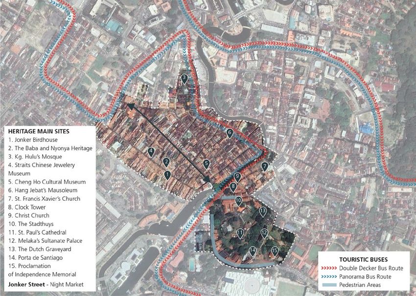
capacity. Along all major roads in Melaka State, the vast The area of Melaka City dedicated as a UNESCO World
majority of trips are made by car. The large number of Heritage Site comprises 288.1 hectare, 45.3 of which are
motorised vehicles causes congestion not just on the designated as the core zone and 242.8 hectare as the
main access routes into Melaka City, but also along its buffer zone. The combination of residential, commercial,
periphery and within the city centre itself. and civic uses within the historical city contributes to its
vibrancy. The numerous historic sites on both sides of
Ayer Keroh to Melaka City – Proposed Green the Melaka River are connected by a network of narrow
Transport Corridor and winding roads, two motor vehicle bridges and one
pedestrian bridge. Originally designed as local residential
The Ayer Keroh to Melaka City road corridor (M29/ M31) access roads, many of the roads must cope with traffic
is an approx. 16km long dual carriageway proposed for beyond their capacity. Melaka has yet to address the
redevelopment into a Green Transport Corridor. The challenges of idle buses that stop to drop-off and pick-
toll station at Ayer Keroh is one of the main turn off up tourists on the narrow streets, private cars that cruise
points from the North-South Expressway for travellers the centre in search of parking spaces, and the poor
visiting Melaka City. The corridor passes through the provision of public and non-motorised transport in a
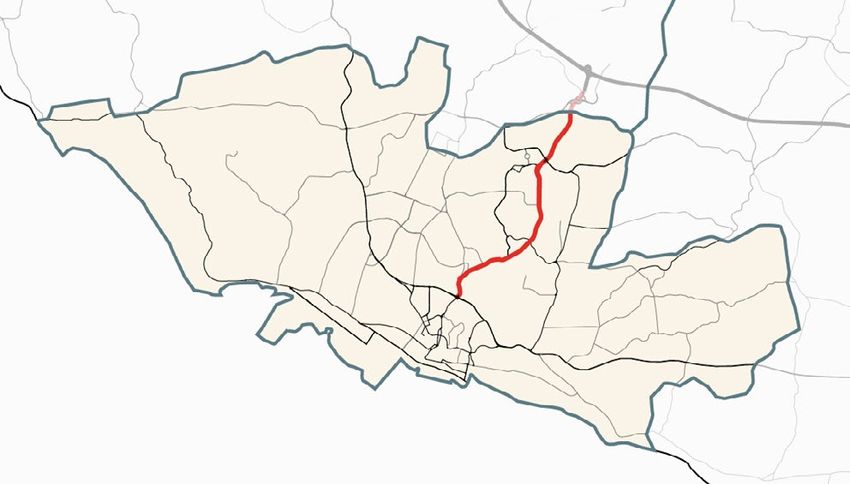
Town of Ayer Keroh, where many administrative and comprehensive manner.8URBAN ANALYSIS 13 Fig. 4. Indicative Green Transport Corridor alignment and main urban components
14   MELAKA - City Context Report

     Non-motorised Travel                                            Public Transport

     Long stretches along the Melaka River have successfully         Melaka is served by a network of public buses with the
     been turned into shared cycle and walkways, attracting          main hub located at the bus terminal Melaka Sentral.
     tourists and locals to the numerous cafes, shops and            MARA Liner, a private bus operator, is focused on rural
     restaurants along the river. Similarly, a large section of      connectivity, whilst Panorama Melaka, a privately held
     the road leading from the Stadthuys and around St               firm, owned by the Melaka State Government, serves
     Paul Hills is closed-off for motorised vehicles. However,       the key routes in, out of, and within the city. Most of
     especially the historic area to the west of Melaka              the city’s historical sites, shopping malls, and hotels are
     River is still experiencing a conflict between motorised        served by Panorama Melaka’s London Bus, a service
     vehicles, pedestrians and trishaws. The narrow streets          primarily designed for tourists and visitors. Aside from
     that are densely lined with small shops and cafes cause         the London Bus, taxis, informal rickshaws and the
     pedestrians to spill into the streets. Pedestrians, including   riverboat cruises are popular among tourists. Especially
     families with small children and other vulnerable groups,       the tri- and rickshaws and the riverboat cruise are
     are forced to dangerously manoeuvre among cars,                 primarily for entertainment rather than serving as true
     exposed to air and noise pollution. Jonker Walk, which          alternative modes of transport. Nevertheless, despite
     in the evenings turns into a night market, is one of the        the availability of several alternative modes of transport,
     busiest streets and exposed to the greatest conflicts           there is an immense influx of private motorised vehicle
     between cars and pedestrians.                                   trips as domestic and international tourists begin to
                                                                     arrive in Melaka on weekends and holidays.
     The Draft Local Plan 2003-2015 acknowledges the
     need for non-motorised modes of transport. It identifies        With the launch of a free bus service in August 2018,
     areas for pedestrianisation near some of the historic           Panorama Melaka aims to assist 290,000 locals
     landmarks in the heritage area, as shown in Figure 5.           annually.9 The three routes served by the free service

                                                                                                 Fig. 5. Melaka UNESCO World Heritage Site
URBAN ANALYSIS 15
include Melaka Sentral to Mydin Hypermarket at Ayer The trend of rapid urbanisation, coupled with population
Keroh via Simpang Kipmart, Melaka Sentral to Mydin and urban employment growth has led to large scale
via Melaka Hospital, and Melaka Sentral to Bachang and sprawling land developments, which threaten
Transit Wet Market.10 While the electric and NGV buses Melaka’s rich natural assets and compromise sustainable
are free for locals, they come at a small cost for tourists. urban development.15 The developable land identified in
The estimated cost of providing the free bus services is the Structure Plan and listed in Figure 7, is 1.2 times the
1.4 million MYR and will be made available by various area of Singapore and 0.8 times the area of Hong Kong,
governmental agencies and private firms through the both cities with significantly larger populations.16
Melaka State Government Public Transport Fund.11
The Fund is managed by the state-owned subsidiary Population Built-up Land
Panorama Melaka. One of the free bus routes runs along Melaka Structure Plan 2035 1.7 million Developable land: 848 km2
the dual carriageway proposed for the development of
the Green Transport Corridor. The proposed corridor is Singapore 2015 5.8 million 284 km2
served by the largest number of bus services, indicating Hong Kong 2015 7.2 million 270 km2
the high travel demand on this route. Anecdotal evidence
suggests that the buses are primarily used by individuals Fig. 7. Comparison of Built-up Land
with lower socio-economic standing, including migrant
workers.
Expansion of built-up areas as envisioned in the Melaka
Structure Plan 2035, could lead to a one third reduction
URBAN CHALLENGES of protected and agricultural land.17 Furthermore, Melaka
has recently focused on the development and reclamation
Melaka faces urban challenges that are multi- of coastal areas.18
fold, particularly in terms of mobility. Three of the
most notable urban challenges include a lack of In a state where nearly two thirds of land are classified
environmental sensitivity in land consumption, the as ESAs, local government officials are limited in their
increase in traffic congestion, and the limited usage of capacity to cope with complex issues in providing services
public transportation. and stewardship of the urban environment. As a result
of the land consumption trends and increasing urban
Land Consumption sprawl, the Melaka State and its local governments must
address issues such inequities in service provisions, and
Over the last two decades, Melaka has urbanised rapidly, encourage the widening of mobility options as a decrease
reaching an urbanisation rate of 86.5%.12 The city’s in density will most likely increase trip numbers and trip
population is expected to increase by 120,000 people to lengths. A need for more sustainable urban development
nearly one million residents between 2011 and 2020.13 that integrates with transport planning is evident.
Furthermore, while total employment numbers increased,
particularly urban employment, rural employment has Traffic Congestion
seen a steady decline, as shown in Figure 6.14
Melaka’s UNESCO World Heritage area has been one
of the state’s greatest assets, including for economic
growth. However, the growing number of tourists
it attracts has also been one of the major challenges
Melaka faces, particularly regarding its mobility system.
The exponential increase in traffic congestion has not
only affected Melaka’s competitiveness in attracting
tourists, but also the profitability of small businesses,
shopping malls, and entrepreneurial business ventures.
The current levels of tourist and visitor arrivals are
straining the mobility system and are causing congestion
along key access routes as well as in the central area.
Weekends, holidays and peak hours experience the
greatest volumes of traffic and result in traffic congestion.
For example, the average daily traffic volume on the
M29/ M31, the proposed Green Transport Corridor, is
Fig. 6. Melaka urban and rural employment 2010-2014 (Source: GPSC 2018) over 28,000 vehicles, of which 3,000 travel during peak16 MELAKA - City Context Report
Fig. 8. Melaka planned tourist arrivals 2015-2035 Fig. 9. CO2 emissions in Melaka (Source: GPSC 2018)
(Source: Melaka Structure Plan 2035)
hour.19 As predicted in the Melaka Structure Plan 2035 Green Transport Corridor intervention, cars have the
traffic congestion will only worsen with the increase greatest modal share at 57%, followed by motorbikes at
from 16 to 25 million tourists and visitors between 2015 30%, while buses comprise only approximately 1%, as
and 2035, if no action is taken. Congestion is further shown in Figure 10.21 Furthermore, low public transport
amplified by Melaka’s low public transport mode share and high car modal shares contribute to congestion
of approximately 2%.20 On key radial routes in and out and are also the primary sources of GHG emissions in
of the city, the modal share of public transport varies Melaka. Figure 9 illustrates that road transport causes
between 1 and 4%. Along the road proposed for the 59%of all CO2 emissions in Melaka.22
Fig. 10. Trishaws in Melaka’s Heritage Area (Source: Charlotte Mohn, UN-Habitat)URBAN ANALYSIS 17
C
A
E F
B
D G
I H
J
MAIN RADIAL ROUTES
A Luan Persekutuan 5 (Melaka - Masjid Tanan) F Jalan Negeri M31 (Jalan Bukit Kati)
B Luan Persekutuan 5 (Melaka - Sungai Udang) G Jalan Negeri M27 (Melaka - Bemban)
C Luan Persekutuan 19 (Melaka - Alor Gajah) H Luan Persekutuan 5 (Melaka - Muar)
D Luan Persekutuan 19 (Melaka - Kendong) I Jalan Negeri M100 (Bandar Hilir -Kampung Kendong)
E Jalan Negeri M2 (Melaka - Durian Tunggal) J Luan Persekutuan 5 (Melaka - Muar)
Cars Motorcycles Buses Mini- Buses Trucks
A B C D E
F G H I J
Fig. 11. Modal share on key radial routes [Source: Melaka Structure Plan 2035]18 MELAKA - City Context Report
The various Malaysian states have borrowing restrictions,
as they typically can only borrow from the federal
government. Exceptional borrowing cases must receive
the approval of the federal government and cannot last
longer than five years. Melaka State stopped borrowing
from federal government in 2013 in order to gradually
begin repaying its debts which have surmounted to
approximately 824 million MYR (or $275 million USD).
Ultimately, the goal of the State of Melaka is to become
self-reliant and attract FDI.
Financial Ana l y si s FINANCING MECHANISMS
The State of Melaka employs land-based financing
instruments, which can be used as a potential
FINANCIAL CAPACITY revenue stream. Through the land value capture
mechanism, future increases of land value within and
Melaka State raises a significant amount of own source near surrounding Intervention areas can be used as a
revenues, yet the country is still reliant on transfers from financing tool. The city is aware of the land capture
the federal government and Foreign Direct Investment mechanism as it is outlined within the city’s Green City
(FDI). The state’s revenue is estimated to be around Action Plan. The plan calls for a feasibility study to set up
374 million MYR (approximately USD 90 million), 41% a tax increment financing district in the heritage area.
of which is expected to come from own-source tax This would mean determining future revenues that
revenues. For 13 consecutive years there has been a derive from property taxes ensuring more sustainable
budget surplus with local revenue collection increasing financing of urban renewal projects.
by 6.6% between 2016 and 2017.23 Local government
own-revenues are primarily made up of property taxes, Additionally, the interventions can be financed through
which represents 70-80% of the total local generated associated fees and taxes. For example, parking fees
revenues. Moreover, the State of Melaka’s efficiency can be reinvested into the transport corridor and the
in collecting taxes is high as it manages to recoup heritage area’s mobility network. Given that 90% of
around 83% of total tax which is much higher than the travel throughout Melaka is completed by car, park and
Malaysian average of 60%.24 ride facilities have particularly high revenue potential.
The additional benefit of fees is that they can encourage
Melaka’s projected expenditure in 2018 is 374 million the use of public transport to and from the heritage site.
MYR, with operating expenditures surmounting to This could also potentially have a positive environmental
approximately 72% of the expenditures. Capital impact. However, given that parking fees at certain times
investments will compose approximately 28% as seen have recently been abolished, it might be politically
in Figure 12. difficult to reintroduce them.
Green Public Transport Corridor
Melaka’s aspirations to become a ‘Green State’ by 2020
suggests that the state has been able to attract funding
and expertise from international organisations such as
the Asian Development Bank, primary funder of the
Green City Action Plan, and the Rockefeller Foundation,
which supports Melaka’s development through the 100
Resilient Cities programme. As Melaka seeks to develop
a Green Transport Corridor, one potential financing
method is carbon financing. Yet, to access climate-based
financing, up-front investments are both extremely high
and required in order to become gold-standard certified.
Some of the necessary investments include the collection
and monitoring of environmental data to certify emission
Fig. 12. Projected 2017 Melaka State Management Expenses reductions and other potential outcomes of the project.URBAN ANALYSIS 19
As Melaka currently sets up a GHG Carbon Inventory
and Eco Budget programme as a key element of its
Green City Action Plan, the State might be in a good
position to fulfil these criteria.
Heritage Area Integrated Mobility Plan
It can be expected that several elements of the
Heritage Area Integrated Mobility Plan will require
capital investment in order to be implemented. While
some components can be financed through the city’s
internal revenues, some investments such as physical
infrastructure may be too costly for the Melaka Historical L e g a l A n a lys is
City Council. If the Council struggles to find adequate
revenue streams, it can request funding from the federal
government. There is high potential for the State of
Melaka to access national funds, such as federal level URBAN PLANNING AND TRANSPORT GOVERNANCE
grants as it aligns with the Prime Minister’s 2017 plans STRUCTURE
to enhance the State’s tourism potential.
National Level
Funding is also available from the World Heritage Fund,
which is comprised of both compulsory and voluntary PlanMalaysia is the federal department of town and
contributions from UNESCO member states. The rules country planning, under the Ministry of Housing and
for the protection and preservation of UNESCO World Local Government, which acts as the main advisor to the
Heritage Sites are detailed in an international treaty, state government in all planning matters, including the
namely the ‘Convention concerning the Protection of the use and development of land. PlanMalaysia creates and
World Cultural and Natural Heritage’ adopted in 1972.25 monitors the national development plans which inform
It states that the duty of conservation and protection is the regional and local plans. Malaysia’s second National
primarily that of the state – through its own resources Physical Plan (2015-2020) sets out guidelines, shaping
and international assistance and cooperation. It is also the direction and pattern of land use, environmental
mentioned that the ‘World Heritage Fund’ can be applied conservation and development for Peninsular Malaysia.
for by the state for emergency assistance, conservation,
and management as well as preparatory assistance. At the federal level, the Land Public Transport
Applications can be made to the fund through the federal Commission (SPAD) has the most prominent role
government. As a UNESCO World Heritage Site, Melaka in transport planning and implementation and has
is also eligible to apply for funding from the Conservation played a significant role in improving the quantity and
Trust Fund.26 sustainability of public transport in Melaka. Furthermore,
the Ministry of Public Works’ Road Planning Division is
Given that Melaka receives about 17 million tourists per responsible in the development and maintenance of
year, tourism and associated taxes and user fees may infrastructure, building and road networks.
be used to raise revenue to operate and maintain the
heritage area. There is a heritage tax of 2 MYR (0.50 State Level
USD) per person per night that is levied on hotel guests
(dependend on the category of hotel), as well as a 10 The Melaka State Government has the strongest mandate
MYR (2.40 USD) tourism tax that came into force on over urban planning. The state government develops
the 1st of July 2017. The revenue from the tax is meant the State Structure Plan and Sectoral Plans and has the
to be reinvested in the marketing of the heritage sites mandate over fund allocations to local authorities as
overseas. It is important to attract more tourists as well well as planning approval. The Melaka State Economic
as restore the sites. There is also precedence in Melaka Planning Unit (EPU) coordinates, monitors, and
for collecting entrance fees for specific buildings and evaluates policies, including land development projects
using this for heritage protection purposes. undertaken by state agencies. EPU’s review of policies
and strategies ensures their alignment with Malaysia’s 5
Year National Development Plan.20 MELAKA - City Context Report
Melaka’s state-level apparatus of the Land Public HTJMC). For example, the inefficiency of the planning
Transport Commission is responsible for coordinating administration system and unresponsive development
and planning for the state’s road public transport control system have been cited as the reasons behind
planning and development. In Melaka State, public the struggles with coastal land reclamation in Melaka.31
buses are operated by Panorama Melaka. The operator
has already commissioned a fleet of electric buses with Intervention’s Alignment to Existing Plans and
the goal of becoming more sustainable. Additionally, Policies
some of these bus routes have recently been made free
of charge to encourage greater use. SPAD is preparing the southern region Integrated
Public Transport Master Plan, setting the standard
Local Level for upgrading public transport nationwide. The Plan
is going to be implemented in stages depending on
The Town and Country Planning Act of 1976 (Act 172) financial capabilities of each state; Melaka is mentioned
designated plan development and control systems and as one of the states with this capacity.32
mandated the local government to act as the local level
physical planner.27 Thus, Melaka State is divided into Melaka has already made efforts towards sustainable
four local authorities (municipalities) under separate urban growth through the region’s 2014 Green City
jurisdictions. Action Plan, which is not a legally binding document
but rather guiding principles, outlining the goal to
Planning decisions for Melaka City are guided by the increase the public transport mode share to 60%.
Central Melaka Local Plan developed by local authorities The Plan includes Green Technology Blueprints,
and approved by the state government. However, it is a comprehensive vision to transform Melaka into
noted that these local plans are not updated frequently a Green Technology City State by 2020, and the
enough to provide a sense of certainty and transparency establishment of a Green Technology Council to
in development control.28 The most recent available plan oversee its sustainability efforts.
is from 2015.
Moreover, the Sustainable City Development effort
Concerning transportation at the local level, Melaka that Malaysia’ initiated in 2017 is a 5-year project
Historic City Council (MBMB), one of Melaka State’s that will support urban planning and management to
four municipalities, encourages the creation of new account for sustainability and related economic, social
cycling routes and regulations to provide equal and environmental matters, as well as assist in climate
opportunity to electric bicycle and trishaw riders in risk mitigation and in the adaptation of technologies.
the historic centre.29 However, in contradiction to It is a collaboration between the United Nations
this policy, free parking was recently instituted in the Industrial Development Organisation (UNIDO), several
historical centre on weekends and public holidays local government ministries, the Malaysian Industry
which counteracts this by encouraging greater vehicle Government Group for High Technology (MIGHT), and
use and traffic. the Melaka state government. There is strong political
will for ‘smart city’ interventions, supported largely
Institutional Coordination between National, by the Melaka State government and the Malaysian
State, and Local Planning Industry-Government Group for High Technology
(MIGHT).
The National Council for Local Government (NCLG)
coordinates federal, state and local planning,30 while the In July of 2018, the State of Melaka announced that they
Implementation Coordination Unit (ICU) of the Ministry were to set up a Smart City Advisory Council – managed
of Federal Territory, aims to ensures effective delivery of by the State Economic Planning Unit (UPEN) and with
policy, programmes and projects in order for the public the Melaka Chief Minister’s Department (JKMM) –
to enjoy the benefits and objectives of the national acting as a mediator between the government and the
development plans. people.Data coordination is currently limited, and most
data capture is done manually as there is no automated
Despite the instituted coordinating bodies, in practice system in place.
there appears to be a lack of coordination between
the different levels of government as well as between Furthermore, the Rockefeller Foundation’s 100 Resilient
the different local governments, causing inefficiencies. Cities is funding the development of a resilience strategy
For example, the development process can be stifled for Melaka City. The programme has appointed a
by requiring planning permission from the state resilience officer to identify major resilience stresses and
level, the Melaka Economic Planning Unit (EPU), and risks, working across government departments and with
building capacity among the local authorities (MBMB, civil society.URBAN ANALYSIS 21
Melaka’s primary focus on sustainable development Road Network Administration
is shown through the high level of involvement from
both the public sector as well as numerous international In Malaysia, road management is determined by
agencies. the federal or state authority. Federal roads include
expressway (tolled), national highways, regional road
schemes and minor access roads, whereas state roads
LEGAL FRAMEWORKS RELEVANT TO THE INTERVENTIONS include intra-state and local authority roads.
Land Ownership At a federal level, roads are planned, designed,
constructed and maintained by the Ministry of Work
National Legislation provides the federal government (MOW), in accordance to Ministerial Function Act 1969.
with ultimate ownership over land and strong powers of State roads are the responsibility of the Department of
compulsory acquisition. According to the National Land Work (Jabatan Kerja Raya (JKR)).
Code of 1965 (Act 56), all land belongs to the state
if it has not been alienated or declared as reserved or The Malaysia Highway Authority (MHA) administers all
mining land. It is rented out on up to 99-year leasehold highways and expressways, while other federal and state
agreements.33 roads are administered by JKR. Furthermore, local roads
are administered by the respective local authorities.
The Land Acquisition Act of 1960 gives the state
government compulsory purchase powers for land
needed for any “public purpose.”34 Therefore,
the government has a large scope to implement a
socially beneficial project, which may help facilitate
the acquisition of land where necessary such as for
the Green Transport Corridor. Under the Federal
Constitution 1957, Article 13 stipulates that no land
shall be taken without payment of adequate amount
of compensation to the affected landowners. However,
neither the Land Acquisition Act, nor the Constitution
define compensation, and there have been instances
of landowner dissatisfaction regarding the disturbance
caused by the Land Acquisition Act.35
Fig. 13. Road Network Administration in Malaysia (Source: Regional Land Public Transport Master Plan, 2017)You can also read