Pedestrian Connectivity Along Victoria Harbour - CORE
←
→
Page content transcription
If your browser does not render page correctly, please read the page content below
Worcester Polytechnic Institute
Digital WPI
Interactive Qualifying Projects (All Years)                                                                       Interactive Qualifying Projects

March 2016

Pedestrian Connectivity Along Victoria Harbour
Alexander Joseph Bosworth
Worcester Polytechnic Institute

Alexander S. Ing
Worcester Polytechnic Institute

Brandon J. Bozeat
Worcester Polytechnic Institute

Mengyue Yu
Worcester Polytechnic Institute

Follow this and additional works at: https://digitalcommons.wpi.edu/iqp-all

Repository Citation
Bosworth, A. J., Ing, A. S., Bozeat, B. J., & Yu, M. (2016). Pedestrian Connectivity Along Victoria Harbour. Retrieved from
https://digitalcommons.wpi.edu/iqp-all/1555

This Unrestricted is brought to you for free and open access by the Interactive Qualifying Projects at Digital WPI. It has been accepted for inclusion in
Interactive Qualifying Projects (All Years) by an authorized administrator of Digital WPI. For more information, please contact digitalwpi@wpi.edu.
44-MWJ-C165

Pedestrian Connectivity Along Victoria Harbour

                     Interactive Qualifying Project Report
          Submitted to the faculty of Worcester Polytechnic Institute
           in partial fulfillment for the degree of Bachelor of Science

                                  Submitted to:
      Sponsors: Designing Hong Kong Limited & Harbour Business Forum
        Liaisons: Paul Zimmerman, Roger Nissim, and Margaret Brooke
                   Advisors: Creighton Peet, WPI Professor
                                       and
                       Jennifer McWeeny, WPI professor

                                Submitted by:
                            Alexander Bosworth
                               Brandon Bozeat
                                Alexander Ing
                                 Mengyue Yu

                      Date submitted: 4 March 2016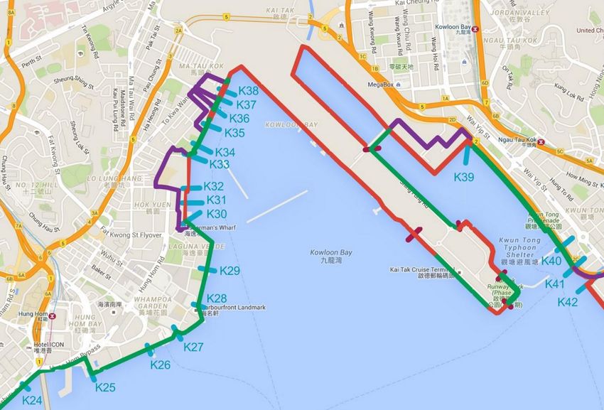
Abstract

       The goal of this project was to provide recommendations for increasing the pedestrian

continuity and accessibility of Victoria Harbour’s waterfront. Through observations, archival

research, and a public survey, we determined the current and future condition of the waterfront,

allowing us to make recommendations for improving pedestrian access. Although only

approximately one third of the harbourfront allows pedestrian access, we identified and

recommend marked detour routes to help connect existing promenades to create a continuous

pedestrian loop around Victoria Harbour.

                                                                                                   ii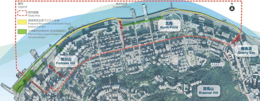
Acknowledgements

       We would like to thank Designing Hong Kong and the Harbour Business Forum for

sponsoring our project and providing us with the resources necessary to complete our research.

       We would like to give special thanks to Paul Zimmerman, CEO of Designing Hong

Kong, and Roger Nissim of Harbour Business Forum for their valuable knowledge, experience,

and guidance.

       In addition, we would like to thank Samuel Lee and the Business Environment Council as

well as Larry Chu and his colleagues from the Development Bureau for additional support for

our project.

       We would also like to thank Worcester Polytechnic Institute and our advisors, Professor

Creighton Peet and Professor Jennifer McWeeny, for providing us with the opportunity to

complete this project.

                                                                                                 iii
Authorship

Abstract ................................................................................................................... Brandon Bozeat
Acknowledgements ................................................................................................. Brandon Bozeat
Executive Summary ..................................................................................................................... All
1.      Introduction .......................................................................................................................... All
2.      Background .......................................................................................................Brandon Bozeat
     2.1      Importance of Waterfronts ................................................................ Alexander Bosworth
     2.2      Walkability .................................................................................................. Alexander Ing
        2.2.1 Definition of Walkability......................................................................... Alexander Ing
        2.2.2 Walkability Studies.................................................................................. Alexander Ing
        2.2.3 Measuring Walkability ............................................................................ Alexander Ing
     2.3 Waterfronts in Selected Cities .............................................................. Alexander Bosworth
        2.3.1 Baltimore ....................................................................................... Alexander Bosworth
        2.3.2 Singapore ....................................................................................... Alexander Bosworth
        2.3.3 Istanbul .......................................................................................... Alexander Bosworth
     2.4 Hong Kong’s Victoria Harbour ........................................................................ Mengyue Yu
        2.4.1 Hong Kong Harbour’s History .................................................................. Mengyue Yu
        2.4.2 Protection of the Harbour Ordinance......................................................... Mengyue Yu
        2.4.3 Functions of the Harbour ........................................................................... Mengyue Yu
        2.4.4 Importance of Walkability in Hong Kong ............................................... Alexander Ing
     2.5 Harbourfront Connectivity and Walkability ................................................Brandon Bozeat
        2.5.1 Connectivity and Accessibility Concerns ..............................................Brandon Bozeat
        2.5.2 Recommendations .................................................................................Brandon Bozeat
     2.6 Summary ......................................................................................................Brandon Bozeat
3.      Methodology.....................................................................................................Brandon Bozeat
     3.1 Determining the Extent of Continuity and Inaccessibility ............................. Alexander Ing
        3.1.1 Observation of the Harbourfront ............................................................. Alexander Ing
        3.1.2 Mapping the Walking Route.......................................................... Alexander Bosworth
     3.2 Determining Appropriate Detour Routes .....................................................Brandon Bozeat
        3.2.1 Comparison of Development Plans and Existing Conditions ...............Brandon Bozeat
     3.3 Determining the Opinion of the General Public............................................... Mengyue Yu
        3.3.1 Surveying Pedestrians Along the Waterfront ............................................ Mengyue Yu
                                                                                                                                                iv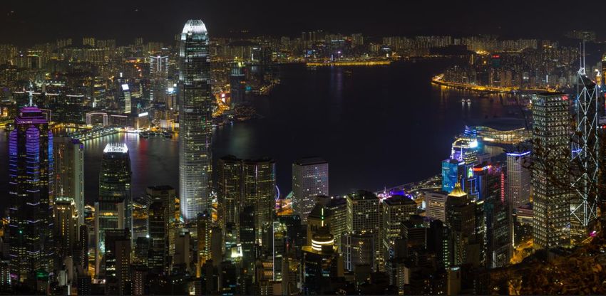
3.4 Summary ......................................................................................................Brandon Bozeat
4.      Results and Analysis .........................................................................................Brandon Bozeat
     4.1 Waterfront Access and Detours......................................................................Brandon Bozeat
        4.1.1 Tsuen Wan ....................................................................................... Alexander Bosworth
        4.1.2 Kwai Tsing ...................................................................................... Alexander Bosworth
        4.1.3 Sham Shui Po................................................................................... Alexander Bosworth
        4.1.4 Yau Tsim Mong ......................................................................................... Alexander Ing
        4.1.5 Kowloon City ............................................................................................ Alexander Ing
        4.1.6 Kwun Tong .................................................................................................. Mengyue Yu
        4.1.7 Central and Western .................................................................................... Mengyue Yu
        4.1.8 Wan Chai ................................................................................................... Alexander Ing
        4.1.9 Eastern ............................................................................................. Alexander Bosworth
     4.2 Public Opinion................................................................................................Brandon Bozeat
        4.2.1 Importance of Waterfronts.......................................................................Brandon Bozeat
        4.2.2 Boardwalk Awareness and Support .........................................................Brandon Bozeat
     4.3 Summary ........................................................................................................Brandon Bozeat
5.      Conclusions and Recommendations ................................................................... Alexander Ing
     5.1 Continuous Harbour Path ............................................................................... Alexander Ing
     5.2 Development Plans ......................................................................................... Alexander Ing
     5.3 Additional Research ....................................................................................... Alexander Ing
     5.4 Conclusion...................................................................................................... Alexander Ing
Appendices ................................................................................................................................... All
     Appendix A: Sponsor Description ......................................................................... Alexander Ing
        A1. Designing Hong Kong ................................................................................. Alexander Ing
        A2. Harbour Business Forum ............................................................................. Alexander Ing
     Appendix B: Interview with Suzanne LaPage ......................................................................... All
        B1. Interview Protocol .......................................................................................................... All
        B2. Interview Transcript ....................................................................................... Mengyue Yu
     Appendix C: Pedestrian Questionnaire .................................................................................... All
     Appendix D: Continuity Overview Map of Victoria Harbour ................................................ All
     Appendix E: Victoria Harbour Waterfront Promenades and Projects ..................................... All

                                                                                                                                                v
Table of Contents

Title ................................................................................................................................................. i
Abstract ........................................................................................................................................... ii
Acknowledgements ........................................................................................................................ iii
Authorship...................................................................................................................................... iv
Table of Contents ........................................................................................................................... vi
Table of Figures ............................................................................................................................. ix
Executive Summary ........................................................................................................................ x
1.      Introduction ............................................................................................................................. 1
2.      Background .............................................................................................................................. 3
     2.1      Importance of Waterfronts ............................................................................................... 3
     2.2      Walkability ....................................................................................................................... 4
        2.2.1 Definition of Walkability.............................................................................................. 4
        2.2.2 Walkability Studies....................................................................................................... 5
        2.2.3 Measuring Walkability ................................................................................................. 6
     2.3 Waterfronts in Selected Cities ............................................................................................. 7
        2.3.1 Baltimore ...................................................................................................................... 7
        2.3.2 Singapore ...................................................................................................................... 9
        2.3.3 Istanbul ....................................................................................................................... 11
     2.4 Hong Kong’s Victoria Harbour ......................................................................................... 12
        2.4.1 Hong Kong Harbour’s History ................................................................................... 13
        2.4.2 Protection of the Harbour Ordinance.......................................................................... 14
        2.4.3 Functions of the Harbour ............................................................................................ 15
        2.4.4 Importance of Walkability in Hong Kong .................................................................. 16
     2.5 Harbourfront Connectivity and Walkability ..................................................................... 17
        2.5.1 Connectivity and Accessibility Concerns ................................................................... 19
        2.5.2 Recommendations ...................................................................................................... 20
     2.6 Summary ........................................................................................................................... 21
3.      Methodology.......................................................................................................................... 22
     3.1 Determining the Extent of Continuity and Inaccessibility ................................................ 22
        3.1.1 Observation of the Harbourfront ................................................................................ 22
        3.1.2 Mapping the Walking Route....................................................................................... 23
                                                                                                                                                      vi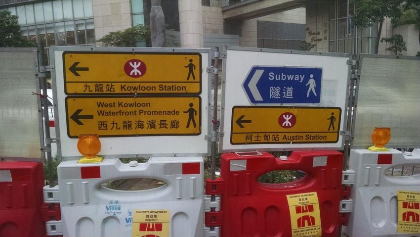
3.2 Determining Appropriate Detour Routes .......................................................................... 23
        3.2.1 Comparison of Development Plans and Existing Conditions .................................... 24
     3.3 Determining the Opinion of the General Public................................................................ 24
        3.3.1 Surveying Pedestrians Along the Waterfront ............................................................. 25
     3.4 Summary ........................................................................................................................... 26
4.      Results and Analysis .............................................................................................................. 27
     4.1 Waterfront Access and Detours........................................................................................... 27
        4.1.1 Tsuen Wan .................................................................................................................... 27
        4.1.2 Kwai Tsing ................................................................................................................... 29
        4.1.3 Sham Shui Po................................................................................................................ 29
        4.1.4 Yau Tsim Mong ............................................................................................................ 30
        4.1.5 Kowloon City ............................................................................................................... 35
        4.1.6 Kwun Tong ................................................................................................................... 41
        4.1.7 Central and Western ..................................................................................................... 44
        4.1.8 Wan Chai ...................................................................................................................... 48
        4.1.9 Eastern .......................................................................................................................... 50
     4.2 Public Opinion..................................................................................................................... 52
        4.2.1 Importance of Waterfronts............................................................................................ 53
        4.2.2 Boardwalk Awareness and Support .............................................................................. 54
     4.3 Summary ............................................................................................................................. 56
5.      Conclusions and Recommendations ...................................................................................... 58
     5.1 Continuous Harbour Path .................................................................................................. 58
     5.2 Development Plans ............................................................................................................ 61
     5.3 Additional Research .......................................................................................................... 62
     5.4 Conclusion......................................................................................................................... 63
References ..................................................................................................................................... 64
Appendices .................................................................................................................................. A-1
     Appendix A: Sponsor Description .......................................................................................... A-1
        A1. Designing Hong Kong .................................................................................................. A-1
        A2. Harbour Business Forum .............................................................................................. A-2
     Appendix B: Interview with Suzanne LaPage ........................................................................ B-1
        B1. Interview Protocol ......................................................................................................... B-1

                                                                                                                                               vii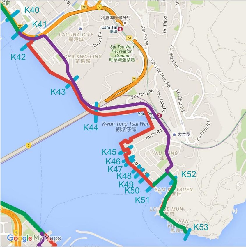
B2. Interview Transcript ...................................................................................................... B-2
Appendix C: Pedestrian Questionnaire ................................................................................... C-1
Appendix D: Continuity Overview Map of Victoria Harbour ................................................ D-1
Appendix E: Victoria Harbour Waterfront Promenades and Projects .....................................E-1

                                                                                                                                viii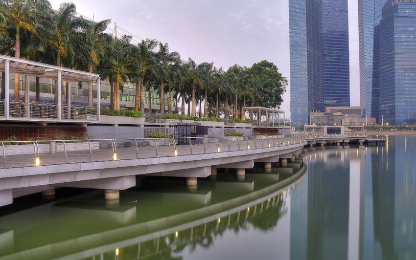
Table of Figures
Figure 2.1: Baltimore Harbor .......................................................................................................... 8
Figure 2.2: Boardwalk at Marina Bay Sands Singapore ............................................................... 10
Figure 2.3: Golden Horn, Istanbul, Turkey................................................................................... 11
Figure 2.4: Victoria Harbour in 1905 ........................................................................................... 13
Figure 2.5: Victoria Harbour in 2016 ........................................................................................... 14
Figure 2.6: Harbour Business Forum study areas ......................................................................... 19
Figure 3.1: Hong Kong resident fishing on the cement support ................................................... 25
Figure 4.1: Map of Tsuen Wan and Tsing Yi ............................................................................... 28
Figure 4.2: Map of Shim Sha Po and Tai Kok Tsui Waterfront ................................................... 30
Figure 4.3: Map of West Kowloon and Tsim Sha Tsui waterfronts ............................................. 32
Figure 4.4: Signage for West Kowloon Waterfront Promenade detour........................................ 33
Figure 4.5: Signage for the Avenue of Stars detour...................................................................... 34
Figure 4.6: Map of Avenue of Stars detour .................................................................................. 35
Figure 4.7: Map of Hung Hom, To Kwa Wan and Kai Tak ......................................................... 36
Figure 4.8: Dog waste bin ............................................................................................................. 37
Figure 4.9: Beginning of the Hung Hom Promenade Pedestrian Overpass .................................. 37
Figure 4.10: Placement of signage for Hung Hom Pedestrian Overpass ...................................... 38
Figure 4.11: Map of the Kai Tak Runway Strip ........................................................................... 40
Figure 4.12: Map of Kwun Tong, Cha Kwo Ling,Yau Tong and Lei Yue Mun .......................... 42
Figure 4.13: Map of Kennedy Town, Shek Tong Tsui and Sai Wan............................................ 45
Figure 4.14: Map of Sai Ying Pun, Sheung Wan ......................................................................... 47
Figure 4.15: Map of Wan Chai and Causeway Bay...................................................................... 48
Figure 4.16: Detour signage in Causeway Bay ............................................................................. 49
Figure 4.17: Map of North Point................................................................................................... 50
Figure 4.18: Map of the Island East .............................................................................................. 51
Figure 4.19: How important is it for the community to have a continuous waterfront walkway
along Victoria Harbour? ............................................................................................................... 53
Figure 4.20: Do you agree that "a continuous pedestrian pathway from Quarry Bay to Causeway
Bay is necessary for the public to fully enjoy the waterfront?" .................................................... 54
Figure 4.21: Are you aware of the proposed boardwalk underneath the Island Eastern Corridor?
....................................................................................................................................................... 55
Figure 4.22: Do you support the construction of a boardwalk under the Island Eastern Corridor?
....................................................................................................................................................... 55
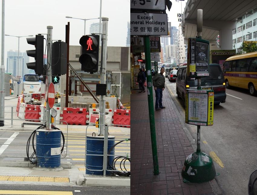
Figure 5.1: Examples of mobile sign posts. On the left is a drum filled with concrete to support a
traffic light in a construction site and on the right is a mini bus signpost .................................... 59
Figure 5.2: Potential signage for a continuous harbour promenade ............................................. 60
Figure 5.3: Victoria Harbour Logo ............................................................................................... 61
Figure 5.4: Signage for the Quarry Bay Promenade ..................................................................... 61
ixExecutive Summary
Many of the most beautiful cities around the world contain harbours with waterfront
walkways. These walkways allow for a city’s residents to enjoy the beauty of the harbour and
access the water. Harbourfronts not only contribute to the beauty of a city but can be a key
element for economic growth. Hong Kong was once a major hub for manufacturing and shipping
due to its location as a major port. However, over the years Hong Kong has refocused its
economy towards tourism and providing financial and other services. This has shifted economic
activity away from using the harbour for commercial shipping, and has led to increased focus on
the redevelopment of the city. The main focus of infrastructure within the city has been
constructing taller residential and commercial buildings, as they have become a larger source of
income and economic growth. This has been prioritized over developing a harbourfront that is
friendly to visitors and enjoyable for pedestrians. As a result, Victoria Harbour, one of the most
iconic harbours in the world, lacks a continuous pedestrian walkway along its harbourfront.
Our project goal was to provide recommendations for improving continuity along
Victoria Harbour’s waterfront. In order to meet this goal, we needed to determine the extent of
discontinuity by finding and observing inaccessible areas of the waterfront, determine detour
routes around these areas, and determine the general public’s opinion of waterfront access and
promenade continuity. After gathering this information, we were then able to determine what
must be done by businesses and the government to improve the waterfront for pedestrian use and
create a more continuous pedestrian walkway.
We were able to determine that most promenades included barrier-free access (BFA), but
did not allow dogs, except for certain areas of Quarry Bay, Tsing Yi and Tsuen Wan. Our
walking data and research allowed us to compile a large chart that summarizes the current and
xfuture status of individual waterfront areas. This chart corresponded to maps that show detour
routes, land and project ownership, and where the waterfront is accessible.
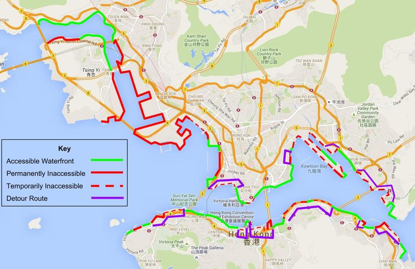
From the information we collected, we concluded that approximately 27 out of 73
kilometers of the harbourfront allows pedestrians to walk along the water. In other words,
approximately 36.7% of Victoria Harbour allows pedestrians to access the waterfront. Our
survey indicated that the general public is in favor of more waterfront access for pedestrians and
that a continuous pathway is important to fully enjoy the harbour. For inaccessible waterfront
areas, approximately 19 kilometers are temporarily inaccessible. The remaining 27 kilometers
includes areas that are permanently inaccessible due to the nature of their use, such as active
working areas and marine police stations, and will likely never be developed into pedestrian
walkways. For the detour routes, we recommend the implementation of signage using consistent
branding, including the Victoria Harbour logo, to direct pedestrians along a continuous route
between waterfront promenades. This project highlights the lack of continuity in pedestrian
walkways around Victoria Harbour and offers recommendations to improve pedestrian
connectivity and navigation.
xi1. Introduction
Coastal cities face the unique challenge of fully utilizing their waterfronts for economic
and cultural growth. A fully utilized waterfront maximizes the efficiency between the public
enjoyment of their water body and economic advantages of the city’s waterfront. If the
waterfront is designed in a way in which any pedestrian path is continuous, the public can enjoy
the waterfront as single continuous entity. If pedestrian walkways along the water are
inaccessible and discontinuous, waterfront access can be restrictive, greatly reducing benefit the
residents and tourists have by living or visiting a waterfront city. Rapid urbanization or the
prioritization of industry, has often established policies and infrastructure that disregard the
presence of continuous promenades. Some cities, such as Baltimore, have successfully balanced
their economies and industries with a pedestrian friendly waterfront, while others, such as Hong
Kong, are still implementing changes to address such concerns.
The rapid development of Hong Kong’s Victoria Harbour as an important economic and
trade center has left much to be desired for pedestrians. Hong Kong has extensively grown its
harbourfront through land reclamation before the Protection of the Harbour Ordinance in 1997
(1997) stopped this process.. Victoria Harbour’s waterfront is now permanently established,
allowing for proper urban planning to occur. However, gaps along the harbourfront promenade
exist due to the presence of businesses, roads, and bridges. In addition to the discontinuities,
certain areas of the waterfront are also difficult or impossible to access from the hinterland
because of physical impediments or the lack of pedestrian infrastructure such as bridges and
walkways (Audi, et. al, 2010).
Many groups and organizations have studied Victoria Harbour’s waterfront for the
purpose of planning a more continuous area and transforming it into a more inviting recreational
1area (Audi, et. al, 2010). In 2008, the Harbour Business Forum (HBF) (2008) identified six major
gaps along the waterfront in a report that reviewed the entire harbour. Based on that study, the
HBF produced recommendations for improving the continuity and utilization of the waterfront
for residents and tourists.
Given that over seven years have passed since the completion of the original study, the
HBF and Designing Hong Kong (DHK) believed it was time to evaluate the progress made in
implementing their recommendations from the 2008 report. Such recommendations include
removing physical barriers and temporary blockages, increasing signage, creating more open
space, and improving visibility of Victoria Harbour (Harbour Business Forum, 2008). In addition
HBF and DHK believed that another review of the Victoria Harbour continuity was in order as
since this report was published, no other research has been conducted to determine what progress
has been made in improving the accessibility and continuity of the waterfront.
The goal of this project was to provide recommendations to the HBF and DHK on how to
improve continuity of the waterfront promenades around Victoria Harbour. While the whole
harbourfront was analyzed for continuity and accessibility, the six specified areas were also
analyzed according to whether or not the recommendations from the 2008 HBF report had been
followed. This information was then mapped using Google maps to create a visual display of all
possible breakpoints and a record of types of breakpoints. The results were used to generate new
recommendations so that the harbourfront could eventually exist as one continuous and
accessible entity. All this information will help decision-makers to determine what needs to be
done by businesses and the government to improve the waterfront in terms of pedestrian
friendliness.
22. Background
This chapter discusses cities from around the world that can serve as analogs to a
problem all waterfront cities face and covers existing research pertaining to more specific project
details on Victoria Harbour’s waterfront. While waterfronts provide a unique source of beauty
and recreation, they are also useful for commercial and industrial uses. Hong Kong is particularly
aware of this problem as its economy has transitioned in recent years. Previous research as
identified pedestrian discontinuity as an issue resulting from allocating waterfront areas to
commerce in between recreational areas.
2.1 Importance of Waterfronts
A waterfront is defined as an area of land or section of a community along a body of
water. Many waterfronts were established for economic purposes such as shipping and industrial
areas. Recent waterfronts have evolved into vibrant districts with public parks, residential areas,
public attractions, and retail spaces blended together. Residents and governments establish and
maintain successful waterfronts by skillfully balancing economic and commercial activities with
public spaces, the environment and aesthetics. Engineering and design considerations for a
successful waterfront include adequate infrastructure with ease of access, transportation, public
amenities and sufficient retail space for encouraging social gatherings and social interaction.
Examples of world renowned waterfronts that enjoy substantial year-round economic and social
activity include Baltimore, London, Paris, Cape Town, Dubai, Helsinki, Istanbul, Rio de Janeiro,
San Francisco, Singapore, Sydney, and Venice.
32.2 Walkability
To have a continuous and accessible waterfront, the walkability of the harbourfront has to
be considered and methods to evaluate its walkability determined. The methods that are
commonly used for assessment have to balance both the quantitative aspects, such as physical
accessibility, ease of navigation, and number of roads crossed, with qualitative aspects, such as
how safe a path is or how crowded a path is. A method for assessing walkability, or combination
of methods must have a balance of quantitative and qualitative aspects in order to more
effectively analyze the harbourfront.
2.2.1 Definition of Walkability
Walkability as a word has no formal Oxford English Dictionary definition; however, it is
a commonly used term in engineering and urban planning and design. Steven Abely (2005),
managing director for Abley Transportation Consultants and a 2015 MacLean Citation defines
walkability in a number of his papers as “the extent to which the built environment is walking
friendly” (p. 3). This definition, while providing an accurate description of walkability for most
studies, is too broad for the specific goals of this project. A more useful definition of walkability
in Hong Kong is “the extent to which characteristics of the built environment and land use may
or may not be conducive to the residents in the area walking for either leisure, exercise or
recreation, to access services, or travel to work” (Hung et. al, 2015, p.1). This definition is
appropriate for the focus of our research because it encompasses the potential uses of the
Victoria Harbourfront. In addition, it focuses specifically on how the built environment and land
use affect walkability.
42.2.2 Walkability Studies
There are multiple studies in place to quantify and measure walkability, ranging from
simple check lists to complex algorithms to try and determine how walkable or unwalkable a test
area is (Audi et. al, 2010). The Walkability checklist produced by Safe Routes: National Center
for Safe Routes to School (2015), uses a checklist to try and answer five questions about a
walking route and uses a rating system to determine the walkability of the route in a subjective
manner. In addition, it provides simple suggestions on how to improve problems that might have
been encountered while walking the route. While unsupported in Hong Kong, the website Walk
Score (2015) uses information from a database to calculate a walk score and provide feedback on
how accessible certain amenities are to the average person walking to them.
A more in-depth analysis of walkability uses Geographic Information Systems (GIS) to
analyze how walkable a route is based on quantitative and qualitative data (Esri.com, 2015). GIS
are designed to help “capture, manage, analyze, and display all forms of geographically
referenced information” (p. 2) and then help to use those data to “understand, question, interpret,
and visualize… in ways that reveal relationships, patterns, and trends” (p. 2). In relation to Hong
Kong, papers such as those by Chan (2009), Hung et. al (2015) and Kelly et. al (2011), a study in
the United Kingdom, all use GIS to help them assess walkability. Chan’s (2009) study combines
multiple methods of existing studies and applies them to Hong Kong with the aim to quantify the
relationship between the built environment and the pedestrian. Hung et. al (2015) use the Global
Walkability Index and the Asian Development Bank/Clean Air for Asian Cities methods of
analysis and modify them to better fit Hong Kong. They ultimately track a series of nine
variables to compile their GIS.
52.2.3 Measuring Walkability
Walkability is typically measured with specific quantitative metrics as well as qualitative
observations in order to be accurate (Audi et. al, 2010). Different criteria of walkability,
however, are more important to different people. One frequently used technique to assess
walkability is the Pedestrian Environment Review System (PERS) (Transport Research
Laboratory, 2010). This technique uses quantitative and qualitative data to assess the street
environment. Crossings, public transport, public spaces, waiting areas, interchange spaces
between different modes of transport, and footways, footbridges and subways are the six factors
that the PERS uses to evaluate a given environment. The Global Walkability Index (GWI),
another index, uses 11 factors to determine walkability: availability of a crossing, pedestrian
count, length of surveyed stretch, obstructions, maintenance and cleanliness, amenities, disability
infrastructure and sidewalk width, motorist behavior, walking path, modal conflict, security from
crime, and crossing safety (Krambeck, 2008). The Scottish Walkability Assessment Tool
(SWAT) evaluates walkability by focusing on functionality, safety, aesthetics, and destination,
with each of those categories having measurable items such as type of path, pedestrian signage,
directness of path, type of pedestrian crossings, and crossing aids (Aspinall et al., 2008). The
Bikeability and Walkability Evaluation Table (BiWET) evaluates similar factors such as parks,
historic buildings (i.e., attractiveness of the path), sidewalks, green space, open space, bicycle
lanes, billboards, and residential and business areas (Hoedl et al., 2010). Each study’s criteria
cover most of the factors needed to quantitatively and qualitatively assess the walkability of a
target area, and these criteria and their associated techniques of analysis can be applied to
determine how walkable an area is in order to provide a complete study.
62.3 Waterfronts in Selected Cities
Cities around the world have waterfronts and harbours similar to Hong Kong’s Victoria
Harbour. Many cities have faced a similar problem of the underuse of their waterfronts and have
over the years found useful ways to overcome these issues. In the 1950s, Baltimore, Maryland,
began renewing its harbourfront, bringing in new businesses, entertainment, and residential
buildings (Kostopoulou, 2013). Conversely, Singapore’s economy was growing so fast that it
needed to expand to the harbour front. This encouraged the development of a harbourfront with
local businesses, tourist attractions, and residential areas (Gwee, 2012). Istanbul is an example of
an older city with a long and complex history due to its geographical location. Istanbul showed
the world that instead of adding more, and getting rid of developments along its harbourfront,
Istanbul could improve it (Alamuddin, 1987).
2.3.1 Baltimore
The Inner Harbor of Baltimore was once a large commercial center for trade, but now it
is a historic port and tourist attraction. As explained by Kostopoulou (2013), before Baltimore
struggled to adapt to the shift in economic conditions in the mid-twentieth century, its economy
developed and relied on its harbor for shipping and industry. According to Kostopoulou, the
1904 Great Baltimore Fire left much of the harbourfront destroyed, thus leaving many people
unemployed. It took many years for Baltimore to rebuild its harbourfront to allow ships to dock
in its port. Kostopoulou mentions that large cargo ships began to be used in the mid-twentieth
century and Baltimore was unable to improve its docking facilities to accommodate these larger
ships. Eventually, everything was abandoned, and the Inner Harbor was no longer a large
shipping port (Kostopoulou 2013).
7During the late 1950s and early 1960s, the renewal of the Inner Harbor began. During
that time, the waterfront was transformed by incorporating entrepreneurial activities such as
businesses and banks, commercial attractions such as shopping centers and small stores, and
environmental activities such as land parks, walkways and aquariums. Kostopoulou’s research
indicates that the city of Baltimore believed that the best way to bring in tourist and locals to the
waterfront, was to make it more enjoyable. More importantly, people are going to need to walk
around these districts, therefore, it is important to provide walkways accordingly along the
waterfront. In 1973, 1.5 million people attended the Baltimore City Fair in one weekend, with
the festival attracting more tourists to Baltimore Inner Harbour (Kostopoulou 2013). Baltimore
had set the standard for post-industrial port cities, and was awarded Urban Land Institute’s
Heritage Award. In fact, the Urban Land Institute said “the harbor now stands as the model for
post-industrial waterfront redevelopment around the world” (bmoreMedia.com, 2009, para. 3).
Figure 2.1: Baltimore Harbor (Source: Zsmurlo, 2007)
82.3.2 Singapore
Marina Bay is Singapore’s most iconic harbourfront located in the southern area of the
city. As Gwee (2012) mentions, the Marina Bay was being developed in 1969, 360 hectares of
reclaimed land was added to the existing Central Business District. The purpose of this
development was to alleviate challenges faced by economic growth and to maintain Singapore’s
position as a leader in finance and business (Gwee, 2012). As mentioned by Yee and Ng (2007),
the reclamation work began in 1969 and lasted until 1992, with long term plans for the Marina
Bay being made by the Urban Redevelopment Authority’s 1983 conceptual Master Plan. Marina
Bay is Singapore’s most iconic harbourfront located in the southern area of the city. As Gwee
(2012) mentions, the Marina Bay was being developed in 1969, 360 hectares of reclaimed land
was added to the existing Central Business District. The purpose of this development was to
alleviate challenges faced by economic growth and to maintain Singapore’s position as a leader
in finance and business (Gwee, 2012). As mentioned by Yee and Ng (2007), the reclamation
work began in 1969 and lasted until 1992, with long term plans for the Marina Bay being made
by the Urban Redevelopment Authority’s 1983 conceptual Master Plan.
9Figure 2.2: Boardwalk at Marina Bay Sands Singapore (Source: Chen, 2010)
One of the main objectives for the Urban Redevelopment Authority (URA) was
walkability along the waterfront. According to the property report done by the Marina Bay
Residences (2008), the URA planned to complete two promenades, completing a 3.5 km
waterfront loop along the bay. This walkway would link the Merlion Park, Esplanade Theatres,
and the ArtScience Museum with the integrated resort, Marina Bay Financial Centre and The
Fullerton Heritage. The property report mentions that this walkway not only connects local
businesses and entertainment venues along the bay area, but allows for visitors to walk right up
to the edge of the water. In fact, the plans for the Marina Bay loop will be part of an 11.7 km
waterfront route that goes around the Marina Reservoir. This will link the Gardens by the Bay,
the Marina Barrage and the new Sports Hub. The 3.5 km waterfront loop acts as a bridge,
connecting the entire harbourfront together, making it continuous and accessible to tourists and
Singapore local residents. Renowned Australian architect Philip Cox commended the Marina
Bay area as a “‘new focus of the city’ and a way for Singapore to become ‘the most successful
maritime city in the world’” (Marinabayresidences.com, 2008, para. 15.).
102.3.3 Istanbul
Istanbul’s Golden Horn has one of the oldest harbourfronts in the world according to
Alamuddin (1987). It was used during the Byzantine Empire by the city of Constantinople’s
navy. Because of its rich history, it has become one of the most popular tourist attractions in
Istanbul. His research depicts that prior to the 1980s, the 8 km long sea inlet was being heavily
polluted by industries located along its banks. Being a bridge between Europe and Asia, Istanbul
relied on capitalism, rather than centralized governance for its economic system; therefore, many
industries were built along the harbourfront. Alamuddin states that Mayor Dalan of Istanbul
proposed to clean up the Golden Horn in 1984, making this one of the largest environmental
improvement projects in the world.
Figure 2.3: Golden Horn, Istanbul, Turkey (Source: Yildiz and Gulsen, 2009)
According to Alamuddin, the first step to improving the harbour, involved removing
“disagreeable” buildings, relocating people, relocating industries to an industrial zone, and
restoring historic buildings for cultural and tourist use; these historic buildings would feature a
11“green area” designated for recreational use. The second step required the installation of a
sewage collection system along the coast to clean the water. The final step was to keep parks in
cleared areas to make the surrounding harbour look nice. Alamuddin notes that the reduction of
pollution and removal of industry from the harbourfront improved aquatic life and reduced
automotive traffic within the city. This allowed for more continuity along the harbourfront as
most industries were relocated. With buildings removed, industries relocated, and historic
buildings and museums restored along the harbourfront, the waterfront became more continuous
and accessible to the public. With the harbourfront being cleaner and less congested, it
encouraged more tourism in Istanbul (Alamuddin, 1987).
2.4 Hong Kong’s Victoria Harbour
Situated between Hong Kong Island and Kowloon peninsula, Victoria Harbour is the
world-renowned symbol of Hong Kong. Its natural beauty and economic value have attracted the
attention of tourists and businesspersons from all around the world to Hong Kong. Victoria
Harbour has also become one of the largest global transportation centers with its unique location
and shipping infrastructure (Carroll, 2007).
12Figure 2.4: Victoria Harbour in 1905 (Source: HK Central Library, 1905)
2.4.1 Hong Kong Harbour’s History
Victoria Harbour has always played an important role in the history of Hong Kong
(Carroll, 2007). After acquiring Hong Kong during the First Opium War (1839-1842), Britain
gained a free port to use in trade with China, and an era of high volume trading between Europe
and Asia began. After the Opium War ended, Hong Kong became the Asian headquarters for
many British companies, and similarly, the connections between local Chinese merchants and
overseas Chinese made Hong Kong a commercial base for trade with Southeast Asia. In the latter
part of the 20th century, as cheaper labor appeared in Shenzhen and other Mainland Chinese
cities, manufacturing gradually declined in Hong Kong, causing its major economic system to
change. Financial and commercial services and tourism are now the biggest supporting sectors of
Hong Kong’s economy. Due to this change and the decrease in shipping activity, Victoria
13Harbour has been undergoing a transition from an industrial and trade center to a combination of
commercial and recreational uses.
Figure 2.5: Victoria Harbour in 2016
2.4.2 Protection of the Harbour Ordinance
Since the 1800s, land reclamation within Victoria Harbour has contributed to Hong
Kong’s economic growth by adding more land to the waterfront area. In 1997, the Legislative
Council of Hong Kong passed the Protection of the Harbour Ordinance (1997), which gave
government the control over the land reclamation of Victoria Harbour. This ordinance states that
“the harbour is to be protected and preserved as a special public asset and a natural heritage of
the Hong Kong people, and for that purpose there shall be a presumption against reclamation in
the harbour” (p. 531). This was done in an attempt to solve the problems caused by the
narrowing of the harbour due to land reclamation. Although the bill does not apply to already
planned reclamation sites, no additional harbour land filling can be done for the following 999
years. The passage of the Protection of the Harbour Ordinance has significantly limited the land
14development of the harbour, thus prompting efforts to plan better uses of the harbourfront since it
is an especially important resource for Hong Kong.
2.4.3 Functions of the Harbour
Victoria Harbour serves many purposes including commercial shipping, tourism, and as a
recreational venue. Its waterfront became crucial for the growth of industry and finance,
resulting in the establishment of policies and infrastructure to support these areas of Hong
Kong’s economy. In this section, the discussion is focused on the usage of Victoria Harbour as a
commercial shipping port, and as a tourist attraction.
Victoria Harbour is strategically located adjacent to major shipping trade routes to and
from China and the rest of Asia, and it has modern marine terminals (Harbourfront Commission,
2011). It is also home to most of the port facilities, with 220,000 ships docking in the harbour on
average every year. Hong Kong Port is a world-class port and the largest container port serving
south China. The port produces 1.4% of Hong Kong’s GDP amounting to 21 billion US dollars.
The commercial port is an important foundation of Hong Kong’s economy serving a key role in
trade and logistics sectors. Hong Kong Port’s core commercial port activates are container ship
operations. Around 400 container liners serve Hong Kong weekly, connecting to over 500
destinations around the world. Passenger ships, oil tankers, and transiting ships for the Shenzhen
ports and local vessel activities also dominate part of the overall operations in the Victoria
Harbour ports. As much as the shipping brings benefits to Hong Kong’s economy, its large
occupancy of the harbour space has created problems for the harbourfront’s walkability and
accessibility.
Tourism has become extremely important to Hong Kong’s economic viability. The
famous dramatic skyline and night time viewing of Victoria Harbour attracts numerous visitors
15to the city every year. As a sophisticated international city, Hong Kong’s cultural diversity and
cosmopolitan lifestyle are also the core of its attraction. There were a total of 45 million travelers
who went to Hong Kong in 2015 alone, and the majority of them were from mainland China
(Tourism Commission, 2015). Many tourists utilize what the harbourfront has to offer, along
with enjoying Hong Kong’s impressive shopping centers and restaurants. However, many
tourists have also experienced difficulties enjoying the waterfront due to the lack of signage,
undeveloped pathways, and the absence of recreational attractions.
2.4.4 Importance of Walkability in Hong Kong
Walking in cities is an important method of transportation, as personal vehicle ownership
in cities can be difficult and public transportation does not always go exactly where an individual
needs to go . To track the number of non-mechanized (walking) trips accurately is a daunting
task without a fare collection system or a restrictive path of travel. The Harbor Business Forum’s
Sustainable Transport Opportunity report states that “on an average weekday, Hong Kong
residents made some 12.3 million mechanised trips, and some 6.8 million walk-only trips. In fact
this amounts [to] nearly 30 million walk trips since all mechanised journeys include walking at
the start and finish” (MVA Hong Kong LTD, 2008, p. 22). Hong Kong has over 7.2 million
residents, which would mean that on average each resident is making four walking trips a day.
By this measure it can be inferred that walking is an important, if not the most important, mode
of transportation in Hong Kong. This makes walkability an important issue in Hong Kong in
general, not just on the waterfront. In addition to being a primary mode of transportation in Hong
Kong, walking is also “the most sustainable form of travel because it consumes no power,
improves health, causes no pollution, is equitable and free, and promotes social interaction and
16public transport usage” (p. 22). Thus Hong Kong has a vested interest in improving walking and
walkability if it wishes to be a healthy and sustainable city.
Approximately 15 percent of the world’s population lives with a disability according to
the World Health Organization, amounting to close to 1 billion people with disabilities globally
(United Nations Secretariat for the Convention on the Rights of Persons with Disabilities, 2015).
This number of disabled persons combined with the growing population in urban areas shows
there is great potential for failure to accommodate these citizens. This failure could potentially
lead to the loss of up to seven percent of any nation’s gross domestic product (GDP) and as well
as opportunity loss of 15-20 percent of the global tourism market share for locations that depend
on tourism. If urban development focused on inclusive universal design in the beginning stages
of design, there would be low or no additional cost to the developer. Adapting to accommodate
persons with disabilities not only benefits them but also other persons who do not necessarily
have a disability but rather have accessibility limitations, such as the elderly, parents with small
children or strollers, and those carrying loads.
2.5 Harbourfront Connectivity and Walkability
Since the Protection of the Harbour Ordinance in 1997, the physical location of the
harbourfront has been constant since land reclamation ceased (Protection of the Harbour
Ordinance, 1997). As a result, many organizations and government departments have focused
their efforts on studying and planning the harbourfront area to enhance the connectivity and
general value of this iconic part of Hong Kong. In 2008, the Harbour Business Forum (HBF)
(2008) conducted a study that recognized that in terms of continuity and accessibility of the
harbourfront, Hong Kong lags behind other major cities around the world. The Harbour
Connectivity Study selected six specific areas along the harbourfront to analyze in order to
17understand the mode and extent of discontinuity in those areas so that recommendations could be
made to improve accessibility.
Because many prominent stretches of the waterfront were already under consideration by
various organizations for planning and development, the Harbour Business Forum (2008)
selected six promising areas to study:
Sai Wan to Sheung Wan
Causeway Bay Typhoon Shelter to Quarry Bay Park
Shau Kei Wan Typhoon Shelter to Heng Fa Chuen
Yau Tong to Kowloon Bay
To Kwa Wan to Hung Hom
Yau Ma Tei Typhoon Shelter to Tai Kok Tsui.
These areas are marked with green lines in Figure 2.6.
18You can also read