CONOVER / LAND O' LAKES COMMUNITY WILDFIRE PROTECTION PLAN - NORTH CENTRAL WISCONSIN REGIONAL PLANNING COMMISSION - North Central Wisconsin ...
←
→
Page content transcription
If your browser does not render page correctly, please read the page content below
CONOVER / LAND O' LAKES

COMMUNITY WILDFIRE PROTECTION PLAN

NORTH CENTRAL WISCONSIN REGIONAL PLANNING COMMISSION
CONOVER / LAND O' LAKES
            COMMUNITY WILDFIRE PROTECTION PLAN

                                  prepared for:

              Joint Town of Conover & Town of Land O' Lakes
                      Wildfire Plan Steering Committee

                                        by:

           North Central Wisconsin Regional Planning Commission

            adopted by Town of Conover Board of Supervisors on:

                                  May 7, 2009

         adopted by Town of Land O' Lakes Board of Supervisors on:

                                  May 13, 2009

________________________________________________________________________

This plan was prepared at the request and under the supervision of the Joint Town of
Conover and Town of Land O' Lakes Wildfire Plan Steering Committee and the
Wisconsin Department of Natural Resources by the North Central Wisconsin Regional
Planning Commission (NCWRPC). For more information, contact:

NORTH CENTRAL WISCONSIN REGIONAL PLANNING COMMISSION
210 McCLELLAN STREET, SUITE 210
WAUSAU, WI 54403

Telephone: 715-849-5510       FAX: 715-849-5110       email: staff@ncwrpc.org

                                 www.ncwrpc.org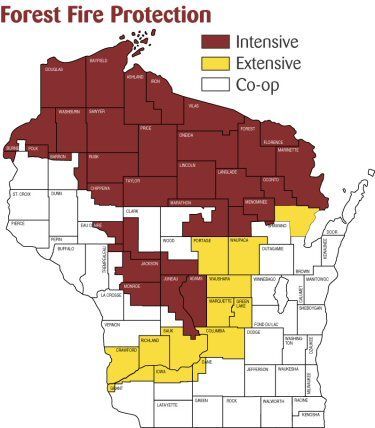
CONOVER – LAND O LAKES CWPP

CHAPTER 1:          INTRODUCTION

     Plan Purpose .         .      .        .    .      .   .   .   1
     Community Wildfire Protection Plan .        .      .   .   .   1
             Collaboration/Planning Committee .         .   .   .   1
             Statement of Intent   .        .    .      .   .   .   2
             Planning Process      .        .    .      .   .   .   2
             Planning Goal and Objectives        .      .   .   .   4

CHAPTER 2:          COMMUNITY PROFILE AND EXISTING CONDITIONS /
                    RISKS

     Location       .       .      .        .    .      .   .   .   5
     Land Ownership         .      .        .     .     .   .   .   5
     Land Use       .       .      .        .     .     .   .   .   6
     Wildland Urban Interface (WUI)         .    .      .   .   .   11
     Development Pattern .         .        .    .      .   .   .   11
     Population and Housing        .        .    .      .   .   .   11
             Publication, Estimates and Projections     .   .   .   11
             Seasonal Population .          .    .      .   .   .   13
             Population Impacts on Wildfire Risk .      .   .   .   13
             Age Distribution      .        .    .      .   .   .   13
             Age Distribution Impacts on Wildfire Risks .   .   .   13
             Employment Location            .     .     .   .   .   14
             Housing Inventory     .        .    .      .   .   .   14
     Weather Conditions/Fire Season         .    .      .   .   .   15
     Tree and Vegetation Mortality          .    .      .   .   .   15
             Insect Infestation    .        .    .      .   .   .   15
             Disease        .      .        .    .      .   .   .   16
             Drought        .      .        .     .     .   .   .   17
             Severe Storms .       .        .    .      .   .   .   17
Other Concerns Regarding Wildfire Risk       .    .   .   .   18
             Access .      .       .      .       .    .   .   .   18
             Fuels near Structures .      .       .    .   .   .   18
             Structure Flammability       .       .    .   .   .   18
     Fire Protection Background .         .       .    .   .   .   18
             Fire Suppression Responsibilities    .    .   .   .   19
     Fire Policy and Programs      .      .       .    .   .   .   22

CHAPTER 3:          RISK ASSESSMENT

     Elements of Risk Assessment .        .       .    .   .   .   24
     Planning Units.       .       .      .       .    .   .   .   24
     Risk Assessment Methodology/Analysis         .    .   .   .   28
             Risk Assessment Mapping      .       .    .   .   .   28

CHAPTER 4:          MITIGATION STRATEGY

     Proposed Mitigation Strategies       .       .    .   .   .   35

             Recommended Mitigation Actions       .    .   .   .   35

             Vegetative Treatments in Planning Units   .   .   .   37
             Public Outreach and Education        .    .   .   .   38
             Treatment of Structural Ignitability .    .   .   .   39
             Evacuation Planning .        .       .    .   .   .   43

CHAPTER 5:          IMPLEMENTATION

     Priority Mitigation Projects .       .       .    .   .   .   46
     Mitigation Action Plan        .      .       .    .   .   .   48
             Review and Update Mitigation Action Plan .    .   .   49
             Mitigation Projects Tracking .       .    .   .   .   49
APPENDIX : FUNDING OPPORTUNITIES . . . . 50
GLOSSARY . . . . . . . . . 53
List of Figures
Figure 1: WDNR Fire Protection Areas . . . . . 19
Figure 2: Risk Assessment of Analysis and Results . . . 29
List of Tables
Table 1: Land Ownership In Acres, 2008 . . . 5
Table 2: Land Use Inventory In Acres, 2008 . . . 6
Table 3: Population Trends, 1980-2000 . . . . 12
Table 4: Population Projections, 2010-2030 . . . . 12
Table 5: Age Distribution, 1990-2000 . . . . 13
Table 6: Total Housing Units, 1990-2000 . . . . 14
Table 7: Housing Unit Projections, 2010-2030. . . . 14
Table 8: WDNR Wildfire Suppression Resources . . . 20
Table 9: Local Wildfire Suppression Resources . . . 21
Table 10: Mitigation Action Plan . . . . . 48
List of Maps
Map 1: Location Reference . . . . . . . 7
Map 2: Land Ownership . . . . . . . 8
Map 3: Land Use . . . . . . . . 9
Map 4: Planning Units. . . . . . . . 26
Map 5: Fire Hazard Rating . . . . . . . 31
Map 6: Past Occurrences . . . . . . . 32
Map 7: Significant/Critical Facilities and Infrastructure . . . 33
Map 8: Protection Capability . . . . . . 34
Map 9: Evacuation Routes . . . . . . . 45CHAPTER 1: INTRODUCTION
PLAN PURPOSE
This plan is a Community Wildfire Protection Plan (CWPP) as defined in Title 1 of the Healthy
Forest Restoration Act (HFRA) of 2003. The purpose of this CWPP is to provide the Towns of
Conover and Land O' Lakes, local fire departments, Vilas County, the Wisconsin Department of
Natural Resources (WDNR), and the U.S. Forest Service (USFS) with information and tools to
help them reduce potential risks associated with wildfires and to collaboratively identify wildfire
mitigation actions that will provide solutions to address the impacts of wildfire hazards. The
plan will also assist the citizens of the two towns to prevent wildfires and be better prepared to
deal with wildfire hazards. The plan develops strategies aimed at protecting life, property, and
the natural environment.
COMMUNITY WILDFIRE PROTECTION PLAN
A CWPP is a written document that identifies how a community will reduce its risk from
wildland fires. A CWPP is mutually agreed upon by local, state, and federal representatives and
stakeholders.
A CWPP should be developed in any community that is in proximity to highly flammable
wildland fuels, or is listed as an "at-risk" community in a federal or state risk assessment. The
Towns of Conover and Land O' Lakes are interspersed with highly flammable wildland fuels and
have been identified as "high risk" communities in the Wisconsin Communities-at-Risk (CAR)
assessment.
A CWPP requires the following three elements:
• Prioritized fuels reduction – Identification and prioritization of wildland areas for
hazardous fuels reduction treatments, as well as recommending methods for achieving
hazardous fuels reductions on both private and public lands.
• Treatment of structural ignitability – Recommending measures that homeowners can
take to reduce structural ignitability throughout the at-risk community.
• Collaboration – Ensure a collaborative effort between local and state government in
consultation with federal agencies is used to prioritize fuels reductions and recommend
measures to treat structural ignitability.
Collaboration/Planning Committee
The Conover – Land O' Lakes Community Wildfire Protection Plan development process is
intended to be open and collaborative in its effort to improve the safety of the community and its
resources. The planning committee was made up of representatives from the communities, local
fire departments, and state and federal agencies. The representatives listed below comprise the
Conover & Land O' Lakes Community Wildfire Protection Plan NCWRPC 1core decision-making team that are responsible for the plan and mutually agreed on the plan's
contents:
• Steve Rhode - Conover Town Chair
• Gary Vold - Conover Fire Chief
• Rich Martinson - Conover Fire
• Mary Rasmussen - Conover Citizen
• Dan Balog - Land O' Lakes Town Chair
• Sam Otterpohl - Land O' Lakes Fire Chief
• Dennis Wasielewski - Land O' Lakes Homeowner/Lake Association
• Jim Galloway - Vilas County Emergency Management
• Larry Stevens - Vilas County Forestry
• John Huppert - WDNR Forester-Ranger
• Stephanie Jones - WDNR Wildland Urban Interface Specialist
Statement of Intent
The intent of this plan is to help fire protection agencies, community leaders, and natural
resource professionals to be better prepared to protect the community's residents, property, and
natural resources against the negative impacts of wildfire.
Planning Process
The steps in the Conover – Land O' Lakes Community Wildfire Protection Plan process were
adapted from the publication "Preparing a Community Wildfire Protection Plan: A Handbook
for Wildland-Urban Interface Communities" as follows:
1. Convene Decision Makers and Involve Federal and State Agencies
The process began with a meeting of representatives from local government, local
fire authorities, and state and federal agencies on June 26, 2008 in Conover,
Wisconsin. The meeting was facilitated by the Wisconsin Department of Natural
Resources and the North Central Wisconsin Regional Planning Commission.
• This initial meeting provided overview information on CWPPs, the planning
process, and available grant funding.
• A discussion on roles and responsibilities helped establish the planning
committee (listed above) and determined that the North Central Wisconsin
Regional Planning Commission would facilitate the process and draft the plan
for the towns.
2. Engage Interested Parties
A broad range of interested organizations and stakeholders were contacted and
encouraged to be part of the development of the CWPP. The contact list included
representatives of federal, state, and local land management agencies, homeowner
Conover & Land O' Lakes Community Wildfire Protection Plan NCWRPC 2associations, area lakes district, and others. From these contacts, a working
committee was established to guide the CWPP process.
3. Establish a Community Base Map
Working with WDNR and local representatives, the Regional Planning
Commission developed a base map of the communities that displays inhabited
areas at risk and areas that contain critical infrastructure. The base map also
identifies planning units of the towns as defined by the planning committee.
4. Develop a Community Risk Assessment
Working collaboratively, the WDNR, Regional Planning Commission and local
representatives developed a risk assessment for the area based on fuel hazards,
risk of wildfire occurrences, at-risk infrastructure and other community values at
risk, and local preparedness and firefighting capability.
5. Establish Community Hazard Reduction Priorities and Recommendations to
Reduce Structural Ignitability
From planning committee discussions, the towns established an overarching goal
to "provide for public safety from wildfire." The committees then established
prioritized objectives to achieve that goal. Objectives focused on fuel treatment,
reducing structural ignitability, and improving fire response capability.
6. Develop an Action Plan and Assessment Strategy
Mitigation strategies were developed by the planning committee to help the towns
meet the established mitigation objectives. The mitigation action plan details
specific activities the towns and WDNR plan to undertake to meet the established
wildfire protection objectives.
7. Complete the Community Wildfire Protection Plan
Adoption of the CWPP by the Towns of Conover and Land O' Lakes completes
the plan. The plan is finalized after mutual agreement from the planning
committee is achieved and public comment from open houses is considered and
incorporated into the plan as applicable.
Conover & Land O' Lakes Community Wildfire Protection Plan NCWRPC 3Planning Goal and Objectives
The Towns of Conover and Land O' Lakes CWPP planning committee identified and prioritized
the following goal and objectives to be the foundation for this Community Wildfire Protection
Plan:
Goal: Provide for public safety from wildfire.
Objective 1: Reduce hazardous fuels on private land and around structures (home
ignition zone).
Objective 2: Involve the public in assessing and reducing wildfire hazards in a safe and
effective manner.
Objective 3: Identify and mitigate safety hazards to the public and firefighters.
Objective 4: Improve intergovernmental coordination and cooperation in wildfire
planning and protection.
Objective 5: Reduce hazardous fuels on public land.
Objective 6: Create new approaches to getting wildfire prevention messages to the
public.
Objective 7: Identify needs to improve local fire department suppression capabilities
(both structural and wildfire)
Conover & Land O' Lakes Community Wildfire Protection Plan NCWRPC 4CHAPTER 2: COMMUNITY PROFILE AND EXISTING CONDITIONS/RISKS
This chapter looks at the community profile and some existing conditions in Conover and Land
O' Lakes that may add to the challenges of managing a wildfire, could further fuel a wildfire, or
are considerations related to wildfire mitigation or management.
LOCATION
The Towns of Conover and Land O' Lakes are located in northern Vilas County in north central
Wisconsin; see Map 1 - Locational Reference. The Towns are just north of the City Eagle River
and adjacent to a number of other Vilas County towns with the State of Michigan to the north.
The surrounding towns include Phelps, Washington, Lincoln, Cloverland, Plum Lake, Boulder
Junction and Presque Isle.
The Town of Conover consists of approximately 56,103 acres (87.2 square miles) while Land O'
Lakes has approximately 60,951 acres (95.3 square miles). The Towns are located adjacent to
the Chequamegon - Nicolet National Forest. Although there are no incorporated communities
within the Towns, there are nodes of development around the larger lakes and a few other areas.
LAND OWNERSHIP
Public land ownership accounts for 26,722 acres or 48 percent of Conover's total area and 12,596
acres or 21 percent in Land O' Lakes, see Map 2 and Table 1. In Conover, 44 percent of the land
is within private ownership with 66 percent for Land O' Lakes. The predominant public
landowner in the Town of Conover is Vilas County with 24,231 acres while the State of
Wisconsin has 10,678 acres in Land O' Lakes, associated primarily with the Northern Highland
American Legion State Forest. In addition, 1,030 acres of the public land is owned by the
federal government within the Town of Conover.
TABLE 1: LAND OWNERSHIP IN ACRES, 2008
Type Conover Land O' Lakes Totals
Federal 1,030 0 1,030
State 1,461 10,678 12,139
County 24,231 1,917 26,149
Private 24,564 39,951 64,515
Water 4,817 8,404 13,221
Total 56,103 60,951 117,054
Source: NCWRPC GIS
Since a large amount of land in the Towns is held publicly, government agencies manage a
significant area of the land in the towns. However, it is important to realize that the cast majority
percent of all fires are human-caused. Fires can quickly move from private lands to public land
and vice versa since most private holdings in the town are interspersed within public lands.
Conover & Land O' Lakes Community Wildfire Protection Plan NCWRPC 5LAND USE
Land use is an important determinant in the potential impact wildfire may have on an area and
the necessary mitigation actions. Land use mapping depicts the activities or usage on the land
surface such a woodlands or residential development. An understanding of the land use within
the towns is an important consideration. Map 3 depicts the land use present in the Towns.
The majority of the land in the Towns (80 percent of the total acreage) is woodlands primarily in
use for forestry and recreational activities; see Table 2. Of the remaining 20 percent of the total
area, the land uses consist of residential development (4.8 percent), transportation infrastructure
(3.2 percent), commercial and industrial development (0.5 percent), agricultural land (0.5
percent) and governmental, open space, recreation and water make up the remaining percentage.
TABLE 2: GENERALIZED LAND USE INVENTORY IN ACRES, 2008
Type Conover Land O' Lakes Totals
Agriculture 532 0 532
Commercial/Industrial 303 256 559
Governmental 0 21 21
Open Space 67 110 117
Open Water 4,809 8,411 13,221
Recreation 0 60 60
Residential 3,428 2,173 5,601
Transportation 1,773 1,919 3,692
Woodlands 45,190 48,000 93,190
Total 56,103 60,951 117,054
Source: NCWRPC GIS
Woodlands
Woodlands consist of land that remains undeveloped and includes forestlands (both managed and
unmanaged), water features, and other natural areas. Woodlands account for the largest land use
category within both Towns. With the exception of the large number of lakes with concentrated
residential and scattered development throughout, the Towns are almost entirely covered by
forest. The woodlands cover 45,190 acres of land, or 81 percent of the Town of Conover and
another 48,000 acres or 78.8 percent of the Town of Land O' Lakes.
Certain vegetation types within woodlands present a higher flammability risk than other types.
The following vegetation types in Conover and Land O' Lakes present the highest flammability
risk and are the most volatile (listed in order of highest to lowest risk): jack pine, red pine, oak,
birch-aspen, and mixed hardwoods. Detailed acreage numbers are not available for all lands
within the Towns, however, timber type acreages for County forestlands within the two Towns
provide some indication of the prevalence of certain species in the area. There are 5,148 acres of
jack pine, 2,788 acres of red pine, 756 acres of white pine and 3,347 acres of black spruce
(includes one-mile buffer area around the Towns).
Conover & Land O' Lakes Community Wildfire Protection Plan NCWRPC 6Insert Map 1 location Conover & Land O' Lakes Community Wildfire Protection Plan NCWRPC 7
Insert Map 2 Ownership

Conover & Land O' Lakes Community Wildfire Protection Plan   NCWRPC 8
Insert Map 3 Land Use

Conover & Land O' Lakes Community Wildfire Protection Plan   NCWRPC 9
Open Space
Open space consists of natural areas that do not fit into the woodlands or agricultural categories
and may include grasslands, wetlands (all types), bogs, floodplain areas, and other brush or shrub
lands. A "catch-all" type of category that comprises only 117 acres between the two towns.

Fire characteristics vary, but some of the grasses and shrubs can be a source for flashy spring
fires that create a threat for nearby structures.

Agricultural Land
Agricultural land, including croplands, pastures, and open space, account for 532 acres of land in
the Town of Conover. The agricultural land is located primarily in the central area of the Town.

Croplands/pastures are often open vegetation lands containing tall grasses that can be a source
for quick burning, flashy spring fires that create a threat for nearby structures.

Residential Land
Residential land within Conover includes about 3,428 acres or 6 percent of the Town's area. In
Land O' Lakes, residential land covers approximately 2,173 acres or 3.6 percent of that Town's
area. Residential use in the Towns is primarily made up of single-family homes (94.6 percent in
Conover and 84.2 percent in Land O' Lakes). Mobile homes make up another 4.2 and 5.6
percent in Conover and Land O' Lakes, respectively. The remaining residential land is
comprised of multi-family homes, which make up only about 1 percent in Conover but reach 10
percent in Land O' Lakes. The number of residential units for seasonal use in both Towns is
about double that of full time residences.

From a fire perspective, residential structures represent one of the primary values to protect from
wildfire. Conversely, although not a leading cause, structure fires can result in wild land fire.

Transportation Uses
The local, county, and state roads running through the Towns fall under the land use category of
transportation uses and account for 3,692 acres of land. There is a small airfield near the
intersection of US 45 and CTH B in the eastern part of Land O' Lakes. This category does not
include recreation trails.

Roads lead people into remote areas increasing fire risk in those hard-to-reach areas. However,
roads present a duality in that they are a recognized ignition source but also aid in fighting fires
by providing equipment access.

Institutional / Governmental
Institutional/governmental uses total about 21 acres of land, or 0.03 percent of the acreage in the
Town of Land O' Lakes. The town hall, fire stations, and churches are the main uses within this
category in the Towns.

Commercial / Industrial Land
Commercial and industrial uses make up 559 acres of land between the two Towns. This
accounts for less than one percent of the total area. This development is scattered but primarily

Conover & Land O' Lakes Community Wildfire Protection Plan                              NCWRPC 10
located along major roadways like USH 45 and the various county highways (CTH B and CTH
K).

Recreational Uses
Land O' Lakes has 60 acres (less than one percent) of land designated recreation within the
Town. Trails make up much of the recreation uses in the Towns. Other uses include a number
of picnic and camping sites primarily on county forestland in the Town of Conover. Due to the
town's wooded nature, a number of recreational uses exist within the woodlands land use
category that is not counted under the recreational category.

It is important for both fire management personnel and recreational users to be mindful of the
fact that campers, ATV users, and other 4x4 vehicle users bring ignition risk in difficult to access
areas with high hazard fuels.

WILDLAND URBAN INTERFACE (WUI)

People continue to move from urban and suburban areas to rural areas such as Conover and Land
O' Lakes that offer attractive recreational and aesthetic amenities, especially forests. This
demographic change is expanding the wildland-urban interface (WUI). The WUI is the area
where structures and other human development meet and intermix with undeveloped wildland.
The expansion of the WUI in recent decades has significant implications for wildfire impact and
management. The WUI creates an environment that enables fire to move swiftly between
structural and vegetative fuels. Its expansion increases the likelihood that wildfires will threaten
structures and people.

Through development of this plan, the entire towns of Conover and Land O' Lakes are identified
as wildland-urban interface area.

DEVELOPMENT PATTERN

If a wildfire threatens the forestlands of Conover and Land O' Lakes, many homes and structures
within those forestlands are threatened as well, because of the development pattern within the
towns. Development is concentrated around the town's lakes as well as being scattered along
rural roads, as is often the case in Wisconsin towns. Outside of these concentrations of
development, the vast majority of both Towns remains undeveloped with large, unfragmented
tracts of forestland.

POPULATION AND HOUSING

Population, Estimates, and Projections
Over the past 20 years, the Towns of Conover and Land O' Lakes have experienced a steady
population increase, as shown in Table 3. From 1990 to 2000, Conover experienced a significant
increase in population with a 37.7 percent increase (311 persons), representing a higher percent
change than Vilas County and the state during the same time. Land O' Lakes experienced a
nearly 10 percent increase (79 persons), but trailed the County and state in growth.

Conover & Land O' Lakes Community Wildfire Protection Plan                              NCWRPC 11
TABLE 3: POPULATION TRENDS
                               1980     1990   2000   # '80-'00 % '80-'00
              Conover             826      932  1,137      311       37.7
              Land O'             803      839    882        79       9.8
              Lakes
              Vilas        16,535    17,707    21,033             4,498        27.2
              County
              Wisconsin 4,705,767 4,891,769 5,363,675          657,908         14.0
              Source: US Census and NCWRPC

The Wisconsin Department of Administration (WDOA) Demographic Services Center annually
produces population estimates for Wisconsin counties and municipalities. The estimates are
based on the prior Census and analysis of contemporary data including housing units, dormitory
and institutional populations, automobile registrations, residential electric meters, and others.

The 2008 population estimate for the Town of Conover is 1,262 persons representing another
125 persons over the 2000 population and an 11.0 percent increase. The 2008 population
estimate for the Town of Land O' Lakes is 955 persons representing another 73 persons over the
2000 population and an 8.3 percent increase.

In 2008, WDOA prepared baseline population projections to the year 2035 for Wisconsin
counties and municipalities, utilizing a projection formula that calculates the annual population
change over three varying time spans. From this formula, the average annual numerical
population change is calculated, which is used to give communities preliminary population
projections for a future date.

The Town of Conover's baseline population projections prepared by WDOA predict a steady
increase in population from 2010 to 2030, as shown in Table 4. The projection predicts a 2030
population of 1,542, which is an increase of 405 persons over the 2000 Census. The Town of
Land O' Lakes baseline population projections predict a small drop off before rebounding for a
small increase in population from by 2030. The projection predicts a 2030 population of 974,
which is an increase of 40 persons over the 2000 Census.

                           TABLE 4: POPULATION PROJECTIONS
                             2010     2020   2030    # '10-'30 % '10-'30
              Conover         1,303    1,442   1,542       239      18.3
              Land O'           934      965     974        40       4.3
              Lakes
              Vilas        22,953    24,645    25,720             2,767        12.1
              County
              Wisconsin 5,777,370 6,202,810 6,541,180          763,810         13.2
              Source: WDOA and NCWRPC

Conover & Land O' Lakes Community Wildfire Protection Plan                            NCWRPC 12
Seasonal Population
Since the Census does not provide the number of seasonal residents within a community, the
seasonal population in the Towns was estimated by multiplying the number of seasonal housing
units by the average number of persons per household.
In 2000, the Town of Conover had a full-time population of 1,137 residents and an estimated
part-time/seasonal population of 2,173 residents. At that time there were 1,440 housing units in
Conover, of which 925 or 64% were seasonal. In Land O' Lakes, the 2000 Census showed a full-
time population of 882, and the estimated seasonal population was 1,896. At that time there
were 1,337 housing units in Land O' Lakes, of which 886 or 66 % were seasonal.
Population Impacts on Wildfire Risk
A growing population in the Towns of Conover and Land O' Lakes means more people are living
within the wildland-urban interface and more people are exposed to the threat of wildfire. Based
on statistics, population growth in the WUI is a great concern since 95 percent of the fires are
caused by people. This fact is evident in Map 6 which displays the cause of past fire occurrences
in the Towns.
In addition to the increasing full-time population, the part-time/seasonal population is growing
rapidly as more people are buying second seasonal homes and others are looking forward to
retiring "up north."
Age Distribution
Overtime, there have been moderate shifts in the distribution of population within age groups in
the Towns of Conover and Land O' Lakes, see Table 5. The median age shifts upward as the
population ages. The Towns of Conover and Land O' Lakes have a significantly older
population than the state as a whole.
TABLE 5: AGE DISTRIBUTION 1990 TO 2000
Percent of PopulationIt is helpful to keep in mind that the majority of the target audience for wildfire prevention
messages is over 40 years of age with the significant portion of the audience over 65. It is also
important to consider that the pool of volunteers for staffing local volunteer fire departments
(VFDs) will continue to face challenges. Many VFDs throughout Wisconsin and the U.S. face
recruitment challenges, especially in the 18 to 34 age group, as the median age continues to
climb – attributed to aging baby-boomers.
Employment Location
Where employment is located affects the town's protection capabilities. Protection capabilities
are at their lowest during the day because a number of volunteer firefighters work outside the
area. Many volunteer fire departments lack firefighters during the day. When only a few
firefighters are available on the scene, first responders are sometimes faced with the decision
about whether to initiate suppression activities without enough manpower to secure their own
safety, or delay the interior fire attack until additional forces arrive.
Housing Inventory
The total number of housing units within the Town of Conover grew only slightly as seasonal
units were converted to full-time. Land O' Lakes saw a significant 19.9% increase, well above
the county and state as a whole, see Table 6.
TABLE 6: TOTAL HOUSING UNITS
1990 2000 # 90 - 00 % 90 - 00
Conover 1,420 1,440 20 1.4
Land O' Lakes 1,115 1,337 222 19.9
Vilas County 20,225 22,397 2,172 10.7
Wisconsin 2,055,774 2,321,144 265,370 12.9
Source: US Census and NCWRPC
The growth in the number of housing units in the towns is reflected in Table 7. Based on past
trends for the two towns, the number of additional housing units since the 2000 Census is
estimated. A negligible number of housing units are subtracted from year to year within a given
community. For the distribution of houses and other structures within the towns, see Map 7.
TABLE 7: HOUSING UNIT PROJECTIONS
2010 2020 2030 # '10-'30 % '10-'30
Conover 1,460 1,480 1,501 41 2.8
Land O' 1,603 1,922 2,304 701 43.7
Lakes
Vilas 24,793 27,445 30,381 5,588 22.5
County
Wisconsin 2,620,571 2,958,624 3,340,286 719,715 27.5
Source: WDOA and NCWRPC
Conover & Land O' Lakes Community Wildfire Protection Plan NCWRPC 14In 2000, the Town of Land O' Lakes had 14.7 % of its housing stock built prior to 1940
compared with 6.5 % in Conover. Both towns have the same percentage, 22.6, built during the
1990's. The towns compare closely to Vilas County as a whole with regard to age of housing.
The 2000 median value of housing units in Conover was $103,500 compared to Land O' Lakes at
$127,800. For Vilas County the median housing value was $120,200
WEATHER CONDITIONS/FIRE SEASON
The weather plays a very important role in how a fire will behave on a given day. Even a slight
increase in wind speed can significantly increase the flame length and rate a fire will spread. A
drop in relative humidity can make it easier for a forest fuel to ignite and cause it to burn hotter
and faster.
The National Weather Service (NWS) provides fire weather forecasts to land management
agencies to aid in their fire planning, management, and control activities. These specialized
forecasts are based on an interpretation and understanding of weather patterns that affect fire
danger and behavior. Fire weather forecasting requires a unique understanding of environmental
conditions, especially the relationship between topography, fuels, and weather.
History indicates spring to be the most active season for fire in Wisconsin since dead fuels are
abundant, temperatures increase, winds are often gusty, and relative humidity often drops to very
low levels. During the summer, there is usually a decrease in fire danger as fine grass fuels
green up and fuel moisture increases. During the fall, there can be an increase in fire activity as
trees drop their leaves and frost cures the fine fuels. However, due to shorter day length, higher
humidity, and cooler temperatures fall fire season is typically not as active as the spring fire
season. Typical fire weather seasons in Wisconsin are as follows:
• Spring – April 1 to June 15
• Summer – June 15 to September 1
• Fall – September 1 to November 15
These fire weather seasons are general dates. Wildland fires can occur during any month of the
year whenever the ground is not snow covered.
TREE AND VEGETATION MORTALITY
Tree and vegetation mortality create more fuel for wildfire. In Conover and Land O' Lakes,
causes of tree and vegetation mortality are many. Some causes of concern in the area include
insect infestation, disease, drought, and downed trees from storms.
Insect Infestation
Forestlands in Conover and Land O' Lakes are generally in good health and free of significant
insect infestation, though periodic outbreaks do occur and problems do exist in certain stand
types. The following descriptions from the WDNR provide information on four insect
Conover & Land O' Lakes Community Wildfire Protection Plan NCWRPC 15infestations of concern in northern Wisconsin: jack pine budworm, spruce budworm, forest tent caterpillar, and gypsy moth. Trees in poor health or under drought stress may decline and die after repeated severe defoliation. Furthermore, defoliation will sometimes cause stress in otherwise healthy trees that may attract secondary pests, such as the two-lined chestnut borer. While the trees are bare, the lack of shade will decrease soil moisture during the dry season, which could cause mortality from lack of moisture. Jack Pine Budworm Outbreaks of this budworm occur predominately in stands of jack pine, although Scots, red, and white pines may also be attacked. Trees of all sizes are attacked. Defoliation by the jack pine budworm reduces tree growth, retards regeneration, and causes tree mortality. Spruce Budworm Outbreaks of this budworm occur predominately in stands of spruce and fir, although tamarack, pine, and hemlock may also be attacked. Trees of all sizes are attacked. Defoliation by the spruce budworm reduces tree growth, retards regeneration, and causes tree mortality. Forest Tent Caterpillars The forest tent caterpillar is one of the major defoliating caterpillars in Wisconsin. It is distributed throughout the United States and Canada wherever hardwood trees grow. Forest tent caterpillars cause defoliation and significant growth loss on broad-leaved trees and shrubs. Gypsy Moth The Gypsy moth is an invasive pest. The caterpillars feed on the leaves of many trees, especially oaks, and their populations can grow so quickly that they can strip all the leaves off of entire stands of trees, damaging them severely. Although gypsy moths may not directly cause tree mortality, they create a vulnerable forest that can lead to mortality. Disease Forestlands in Conover and Land O' Lakes are generally in good health and free of significant disease, though periodic outbreaks do occur and problems do exist in certain stand types. The following descriptions from the WDNR provide information on two diseases of concern in northern Wisconsin: Diplodia shoot blight and canker and Sircoccus shoot blight. Although not yet in the area, Vilas County Forestry has identified oak wilt as a pathogen of concern in its County Forest Plan. Diplodia Shoot Blight and Canker/Sirococcus Shoot Blight Diplodia shoot blight and canker and Sirococcus shoot blight are two of the most important diseases of red pine. They can be prevalent on trees of all ages but the most significant damage is generally restricted to seedlings and saplings. Both pathogens have unpredictable outbreak patterns that are often dictated by weather events. Diplodia outbreaks tend to occur during droughts or following hailstorms, while Sirococcus outbreaks often occur following cool, wet spring weather. During outbreaks, many seedlings and small trees can be killed or deformed. Multi-cohort red pine management, or growing small red pine under larger red pine, will increase Conover & Land O' Lakes Community Wildfire Protection Plan NCWRPC 16
the risk of disease development. This is because spores produced on infected large trees are rain-
splashed onto seedlings and smaller trees growing below them.
Oak Wilt
Oak wilt is caused by a fungus that forms a balloon-like swelling in the water conducting vessels
of the oak tree. The obstruction in the vessel slows the movement of water within the tree
causing the leaves to wilt and drop off.
Oaks in the red oak group (black, northern red, northern pin and others with pointed leaf edges)
are most susceptible. Oaks in the white oak group (white, swamp white, burr, and others with
rounded leaf edges) are less susceptible. Oak wilt has been confirmed in forests of northeast
Wisconsin.
Drought
Drought is defined as a deficiency of precipitation over an extended period – usually a season or
more. Drought is a normal, recurring climatic event that is expected to become more frequent as
our climate changes. It occurs in virtually all climatic zones, but its characteristics vary
significantly from one region to another.
Drought causes stress on vegetation that can cause forests to be more vulnerable to insects and
disease as well as lead to mortality in situations of prolonged drought. If mortality occurs over
contiguous forest blocks, an area of increased wildfire fuel will be present in that area. Drought
conditions create dry forest fuels that can lead to additional wildfire starts and cause increased
fire behavior. Drought can extend the active fire season into the summer and fall.
Much of Wisconsin has been suffering drought conditions for the last several years. The U.S.
Drought Monitor currently shows northern and central Wisconsin affected by hydrologic drought
conditions. Conover and Land O' Lakes are shown under moderate to severe drought.
Severe Storms
Severe storms, although not very common in Conover or Land O' Lakes, can cause significant
damage to forestlands. Strong winds from storms can break and uproot trees leading to tree
mortality and additional fuel for fires. In addition, high winds can cause trees to fall onto power
lines, which can start fires and pose an electrical risk to people.
The following is a list of high wind events reported by the National Climatic Data Center for
Conover and Land O' Lakes over the last five years:
• 09/21/07 Land O' Lakes Airport - Strong winds...downed trees, power lines, etc.
• 07/03/06 Conover - High winds...downed trees, power lines
• 06/27/05 Land O' Lakes - Thunderstorms...downed trees
• 06/13/04 Conover - Thunderstorm wind
• 08/26/03 Land O' Lakes - Thunderstorms...downed trees
• 07/20/03 Conover - Strong winds...downed trees, some power lines
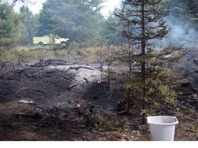
Conover & Land O' Lakes Community Wildfire Protection Plan NCWRPC 17OTHER CONCERNS REGARDING WILDFIRE RISK Other concerns regarding wildfire risk in the area includes access to property, fuels near structures, and structural flammability. These conditions may add to the challenges of managing a wildfire or could provide additional fuel to a wildfire. Educational efforts such as Firewise (discussed later in this plan) would be beneficial to residents to remedy the following situations. Mitigation tactics to address these concerns have been developed for Conover and Land O' Lakes and are discussed later in the section on "Treatment of Structural Ignitability." Access Many of the residential driveways in the Towns present challenges for firefighters to gain access to the property in case of a fire. Many driveways are very long with curves that are too sharp to allow emergency vehicles to gain access to the property. The lack of access or good turnarounds can pose a hazard to firefighters during a fast moving fire by limiting safety zones and escape routes. Some properties have a closed or locked gate making entry difficult or impossible. To exacerbate entry problems, many of the properties with closed or locked gates are owned by absentee property owners that are only around seasonally or part-time so they may be completely unaware of a wildfire situation on their property. Fuels Near Structures Within the Towns, many buildings have vegetation growing around them providing "fuel" near the structures. The area approximately 100 feet around all structures is referred to as the "home ignition zone." If left unmanaged, fire in this area can quickly move from vegetation to buildings. Structure Flammability Many residents in the Towns are not well informed about how to reduce the flammability of their home. Buildings can provide fuel in a wildfire, including garages, campers, and storage sheds. Anything attached to a structure, such as a deck, porch, or balcony is considered part of the structure. These structural attachments can provide the link for a fire to spread from the wildland to the building. FIRE PROTECTION BACKGROUND The state of Wisconsin is divided into three fire protection areas: Co-op, Extensive, and Intensive, see Figure 1, below. Each fire protection area presents a different kind and degree of forest fire problem. The degree of protection has been determined by the amount of forested lands, the hazards and the risks present in the various parts of the state. The Towns of Conover and Land O' Lakes are located within the Intensive fire protection area. Intensive fire protection areas are the most heavily forested and contain the most fire hazards and risk in the state. They have more WDNR fire suppression resources and ranger stations. Fire detection is accomplished with fire towers, aerial patrols, and citizen reporting. The most restrictive debris burning laws are in effect in Intensive fire protection areas. Conover & Land O' Lakes Community Wildfire Protection Plan NCWRPC 18
FIGURE 1 WDNR Fire Protection Areas

                                                             Source: WDNR Website

Fire Suppression Responsibilities
Fire suppression and management activities within the Towns are carried out by four
jurisdictions: state, federal, county, and local in accordance with their respective operations and
management plans and cooperative agreements between the jurisdictions. Primary responsibility
for these activities within each jurisdiction falls to the WDNR (state), USFS (federal), Vilas
County Emergency Management (county), the Conover Fire Department (local), and the Land
O' Lakes Fire Department (local).

Wisconsin Department of Natural Resources
The WDNR has 54 ranger stations that are outfitted with firefighting vehicles, tractors/plows,
and staff to support wildland fire control in Wisconsin. The Woodruff Dispatch Group includes
nine Ranger Stations and covers Lincoln, most of Vilas, Oneida, and Langlade, and parts of
Forest and Marathon counties.

The Eagle River Fire Response Unit (FRU) is the closest to Conover-Land O' Lakes for wildfire
suppression in the Towns, and resources can be drawn from other stations as necessary. Table 8
identifies primary WDNR fire suppression resources within one hour response time for a wildfire
occurring in Conover or Land O' Lakes. In addition, the WDNR hires limited term employees as
seasonal firefighters to assist with suppression and detection efforts. The WDNR has a number
of mutual aid agreements with local fire departments, county agencies, and private contractors.
The State works with fire departments to provide wildfire suppression and in turn offers training
and financial assistance through grants and group purchasing. In addition, the state often
contracts larger pieces of heavy equipment and fire suppression aircraft to augment existing

Conover & Land O' Lakes Community Wildfire Protection Plan                             NCWRPC 19
resources. The WDNR is prepared to mobilize units across the state as the need arises, and has
the ability to request out-of-state resources through either the Great Lakes Forest Fire Compact
or Eastern Area Coordination Center.
TABLE 8:
WDNR WILDFIRE SUPPRESSION RESOURCES (1 hour response window)
Station Personnel Apparatus
Eagle River 1 Forester/Ranger 1 Type 6 Engine
1 Forester 1 Type 4 Engine w/tractor plow unit
1 Forestry Technician 1 Type 8 Engine
Trout Lake 1 Forester/Ranger 1 Type 6 Engine
1 Forestry Technician 1 Type 4 Engine w/tractor plow unit
Lake 1 Forester/Ranger 1 Type 6 Engine
Tomahawk 1 Team Leader 1 Type 4 Engine w/tractor plow unit
2 Forestry Technicians 1 Type 4 Engine w/muskeg low ground unit
1 Type 8 Engine
Rhinelander 1 Forester/Ranger 1 Type 6 Engine
1 Forester 2 Type 4 Engine w/tractor plow unit
2 Forestry Technicians 1 Type 8 Engine
Source: WDNR
U.S. Forest Service
The fire management program on the Chequamegon-Nicolet National Forest (CNF) consists of
four basic factors: fire prevention, fire suppression, hazardous fuels reduction, and prescribed
fire for ecosystem maintenance.
The USFS has primary fire suppression responsibility on all lands including private lands within
the National Forest boundary. In the Conover-Land O' Lakes area, the USFS boundary primarily
abuts the eastern borders of the Towns and includes areas both north and south of Twin Lake.
The USFS-CNF staffs fire equipment and personnel at Ranger Stations in Eagle River to cover
this area. It also has the ability to shift its resources around the CNF from stations in Florence,
Glidden, Hayward, Laona, Park Falls, and Washburn, to support initial attack efforts while still
maintaining adequate fire staffing throughout its fire management units. Through Mutual Aid
and Cooperative Fire Agreements with other federal agencies, WDNR, and local fire
departments, the USFS can request reinforcements for initial and extended attack fires. The
USFS-CNF also has a responsibility to support national firefighting efforts without drawing
down personnel and equipment for adequate local fire protection within the CNF.
Vilas County
The Vilas County Emergency Management Department is available to assist with planning, grant
writing and administration, coordinating training exercises and other assistance related to
preparation and response to emergencies like wildfire. The County Emergency Management
Director is the primary point of contact to obtain additional county and state (including National
Guard) resources as needed. The County has a communications trailer it can dispatch. The
County may also supply heavy equipment primarily through the County Highway Department.
Conover & Land O' Lakes Community Wildfire Protection Plan NCWRPC 20Vilas County operates a countywide 911 emergency dispatch system. The county system has the
capability to page both the fire departments and WDNR for citizen reported fires. This system
has the capability to locate 911 calls from landlines as well as from cell phones.
Conover Fire Department
The Town of Conover Volunteer Fire Department provides fire suppression for the Town of
Conover. The station is located on CTH K adjacent to the Town Hall. The Department provides
structural and wildland fire suppression, rescue, basic emergency medical services, and a basic
level of HAZMAT response capability. The fire suppression resources of the Department are
shown in Table 9, below. The Department has 4 hydrants to access water spaced around the
Town and a well located at the fire station.
There are currently 30 volunteer members on the department including a volunteer chief. The
Conover Fire Department has mutual aid agreements with Vilas County and surrounding
community fire departments.
TABLE 9: LOCAL FIRE SUPPRESSION RESOURCES
Dept. Unit Pump Tank Drop Tank Personnel NIMS Misc. Equip.
Cap. Cap. Cap. Type
Engine 1 1,000 1,000 3 2
Engine 2 1,200 1,500 3 2
Brush 1 200 150 4 Other 200 gpm portable
Tender 1 200 3,000 3,000 2 2 200 gpm portable
Water 2 na 500 gpm portable
Conover
Supply
Rescue 1 250 300 3 na Jaws
Crew 9 5 ATV
Transport
Ambulance 3 3
Engine 1 1,250 1,000 3 2 CAFS
250 gpm portable
Tender 1 2,000 1,000/1,300 2 Other 500 gpm portable
Land 'O
Rescue 250 300 2 na
Lakes
Rescue 1 250 300 3 na ATV
Fire Boat 3 na
Ambulance 3 3
Source: Vilas County EOP
Land O' Lakes Fire Department
The Land O' Lakes Volunteer Fire Department provides fire suppression for the Town of Land
O' Lakes. The station is located in the town center area on CTH B. The Department provides
structural and wildland fire suppression, rescue, basic emergency medical services, and a basic
level of HAZMAT response capability. The fire suppression resources of the Department are
shown in Table 9. The Department has a number of water access points spaced around the Town
as well as 48 hydrants within the Land O' Lakes Sanitary District serving the town center area.
There are currently 16 volunteer members on the department including a volunteer chief. The
Land O' Lakes Fire Department has mutual aid agreements with Vilas County and surrounding
community fire departments.
Conover & Land O' Lakes Community Wildfire Protection Plan NCWRPC 21Fire Policy and Programs There are various programs and policies at the federal and state levels related to community fire planning, fire prevention, and suppression that affect the Towns. Each agency has laws regarding the use of fire and is able to investigate, enforce, and prosecute civil and criminal violations that arise out of fires originating within their jurisdiction. In general, burning laws regulate what, when, and how people can burn, and hold people responsible for damages and suppression costs if their fire escapes. Federal The following information provides a brief overview of relevant federal policies and programs: Healthy Forests Restoration Act (HFRA) – This federal law is designed to promote healthy watersheds and forests through fuels reduction projects on federal lands, community plans, insect and disease protection measures, storm damage clean-up, and threatened and endangered species protection. The HFRA also encourages biomass energy production through grants and assistance to communities to create market incentives for removal of otherwise valueless forest material. National Fire Plan (NFP) – This is a federal interagency plan that focuses on firefighting, rehabilitation, hazardous fuels reduction, community assistance and accountability. The NFP is a long-term investment intended to help protect communities and natural resources. It establishes a commitment to communication, cooperation and collaboration between federal agencies, states, local governments, tribes and interested parties. Federal fire management agencies worked closely with these partners to prepare a 10-year Strategy and Implementation Plan. The NFP also calls for the development of Community Fire Plans to aid in implementing NFP goals. State The following information provides a brief overview of relevant state policies and programs: Permits - The WDNR enforces burning laws and requires permits for debris burning. Permits can be obtained from local emergency fire wardens and DNR ranger stations. Refer to the WDNR web page at http://dnr.wi.gov/forestry/fire/burning-rp.htm to determine what is burnable with a permit and what is not permissible. Structure Zone Maps - In 2007, the WDNR prepared structure zone map books for use by emergency services personnel in Vilas County, including the Towns of Conover and Land O' Lakes. These maps document structure locations and preplanned zones used to coordinate efforts to help protect life, property, and natural resources during fire emergencies. Hazard Mitigation Program - WDNR Forestry's Hazard Mitigation program is an internal funding mechanism utilized to reduce the risk of catastrophic wildfire impacting communities. It focuses on hazardous fuels reduction, prevention/education, and community planning in the wildland-urban interface. The program is a product of the USFS State Fire Assistance - National Fire Plan and has been functioning in Wisconsin since 2001. The program has promoted Firewise practices, resulted in the creation of Community Wildfire Protection Plans, and reduced flammable wildland fuels. Viable projects located in a Community at Risk are prioritized for funding. Conover & Land O' Lakes Community Wildfire Protection Plan NCWRPC 22
This page left blank, intentionally.

Conover & Land O' Lakes Community Wildfire Protection Plan               NCWRPC 23
CHAPTER 3: RISK ASSESSMENT

The risk assessment is a primary component of the Community Wildfire Protection Plan. It
identifies the areas of the community most at risk from wildfire, enabling decision makers to
focus efforts on the higher risk areas and prioritize resource allocations and mitigation activities.

ELEMENTS OF RISK ASSESSMENT

The risk assessment evaluated wildfire risk in Conover and Land O' Lakes by analyzing four key
elements or "layers" of fire information. The four elements are hazard, risk, values, and
protection capability. The Towns were evaluated to determine the areas most at-risk based on
each of the four elements or layers of information. The four elements are defined below.

    •   Hazard - Natural conditions, including vegetation, soils, geology, and topographic
        features that may contribute to and affect the behavior of wildfire.

    •   Risk - The potential and frequency that wildfire ignitions might occur based upon
        historical occurrences over a 20-year period from 1985 to 2005.

    •   Values - The people, property, and significant / critical facilities or infrastructure that
        represent value to protect from losses in the event of wildfire.

    •   Protection Capability - The ability to protect the community from structural and
        wildland fires including preparation, response, and suppression.

PLANNING UNITS

To aid the risk assessment, the Towns of Conover and Land O' Lakes were divided into smaller,
more manageable planning units. The CWPP planning committee identified planning units
based upon commonalities within each planning unit, including distribution of developed areas
and structures. The Planning Unit Boundaries Map displays the planning units identified in the
Towns. The ten planning units are as follows:

        1.      Big Lake Unit                            6.    Portage Lake Unit
        2.      Black Oak Lake Unit                      7.    Stormy Lake Unit
        3.      Land O' Lakes Unit                       8.    North Twin Lake Unit
        4.      Jute Lake Unit                           9.    Buckatabon Lake Unit
        5.      Forest Lake Unit                         10.   Pioneer Lake Unit

The following provides a description of each planning unit including the development pattern in
the area, the number of structures, the number of significant/critical infrastructure, the total land
acreage, and the total land area under residential land use and forestlands. The remaining land
area of each planning unit is made up of open water, croplands/pastures, other non-forestland
natural areas (including wetlands), roadways, and industrial, commercial, and
institutional/governmental areas.

Conover & Land O' Lakes Community Wildfire Protection Plan                               NCWRPC 24
1. Big Lake Planning Unit The Big Lake planning unit is located in the northwest corner of Land O' Lakes north of County Highway B and west of Thousand Island Lake Road. This planning unit is comprised primarily of private woodlands with dense clustered residential areas around Big Lake, West Bay Lake, Mamie Lake and, to a lesser degree, several other lakes within the area. Land records information data indicates that there are 270 structures and one significant infrastructure - a telephone substation plus several water access points. Total land area of the planning unit is 8,655 acres with 4.5 percent (392 acres) developed residential and 91.5 percent (7,917 acres) woodlands. 2. Black Oak Lake Planning Unit The Black Oak Lake planning unit is located in north central Land O' Lakes north of CTH B. This planning unit is characterized by dense clustered residential development around Black Oak and Spring Lakes surrounded by private woodlands. There are 195 structures and significant infrastructure including cell/communications towers, telephone substation, the Conserve School with water facilities and fire hydrant plus several water access points. Land area totals 4,816 acres with 7.3 percent (350 acres) in residential and 87.5 percent (4,213 acres) woodlands. 3. Land O' Lakes Planning Unit The Land O' Lakes planning unit is comprised of the "downtown" area of Land O' Lakes including the airport. Woodlands are still the dominant land cover at 75 percent (1,431 acres) of the land area. Total land area of the planning unit is 1,904 acres with 7.2 percent (137 acres) residential. There are 229 structures and numerous significant infrastructure including: the airport, town hall, fire station, elementary school, the ski chalet historical structure/museum, bulk LP gas storage, sewer and water facilities, etc. 4. Jute Lake Planning Unit The Jute Lake Planning Unit is located in the southwest corner of Land O' Lakes south of County Highway B and west of Deer Farm, Old B and Indian Lake Roads. This planning unit is comprised primarily of county and state forestlands and private woodlands with some residential areas clustered around High and Jute Lakes and some scattered homes. There are 128 structures and two significant facilities - both campgrounds plus several water access points. Total land area of the planning unit is 18,494 acres with 1.0 percent (187 acres) developed residential and 95.1 percent (17,581 acres) woodlands. Of these woodlands, 60 percent is state forest and 6 percent county forest. 5. Forest Lake Planning Unit The Forest Lake planning unit is located in central Land O' Lakes, south of CTH B and west of West Big Portage Road. This planning unit is characterized by dense clustered residential areas around Forest and Moccasin Lakes surrounded by private woodlands. There is also significant residential development on CTH S and in scattered pockets on various other lakes. There are 245 structures and several water access points for significant infrastructure. Land area totals 9,098 acres with 6.2 percent (563 acres) in residential and 91.6 percent (8,330 acres) woodlands. Conover & Land O' Lakes Community Wildfire Protection Plan NCWRPC 25
Insert Map 4 Planning Units

Conover & Land O' Lakes Community Wildfire Protection Plan   NCWRPC 26
6. Portage Lake Planning Unit
The Portage Lake planning unit is located in the southeast corner of Land O' Lakes south of CTH
B and the airport but also includes the area east of US 45. This planning unit is characterized by
dense, clustered, residential areas around Big and Little Portage Lakes surrounded by private
woodlands. There is also significant residential development on CTH B and other scattered
locations. There are 335 structures and significant infrastructure includes the Town Garage, a
communications tower and several water access points. Land area totals 9,721 acres with 5.7
percent (556 acres) in residential and 88.9 percent (8,645 acres) woodlands.

7. Stormy Lake Planning Unit
The Stormy Lake planning unit is located in the northwest corner of Conover, north of CTH K
and west of US 45. This planning unit is characterized by dense, clustered, residential areas
around Stormy Lake, Little Tamarack Flowage, and other smaller lakes including Marshall,
Clair, Deer and Heart with other scattered residential areas. There are 393 structures and
significant infrastructure including a gas pipeline substation, a telephone substation, 3
campgrounds, and a fire hydrant. Land area totals 16,635 acres with 6.5 percent (1,085 acres) in
residential and 86.4 percent (14,376 acres) woodlands. Of these woodlands, 58 percent is county
forest and 3.4 percent is state land.

8. North Twin Lake Planning Unit
The North Twin Lake planning unit is located in the northeast corner of Conover, east of US 45
and north of Church Road. This planning unit is characterized by dense residential development
around North Twin Lake and development along CTH K, Church Road and Monheim Road.
There are 406 structures and significant infrastructure including the Town Garage, Fire
Department, Town Hall / Community Center, transfer site, electrical transmission line with
substation, cell tower, telephone substation and two hydrants. Land area totals 14,934 acres with
3.9.percent (589 acres) in residential and 91.8 percent (13,712 acres) woodlands. Of these
woodlands, 51 percent is county forest, 7.5 percent is part of the Nicolet National Forest and 6.5
percent is state land.

9. Buckatabon Lake Planning Unit
The Buckatabon Lake planning unit is located in the southwest corner of Conover, south of CTH
K and west of US 45. This planning unit is characterized by dense residential areas around
Upper and Lower Buckatabon, Hunter, and Torch Lakes with development along US 45. There
are 433 structures and significant infrastructure including Camp Ramah, three campgrounds, a
telephone substation and two hydrants. Land area totals 13,373 acres with 7.6 percent (1,019
acres) in residential and 88.3 percent (11,811 acres) woodlands. Of these woodlands, 68 percent
is county forest and 1.0 percent is state land.

10. Pioneer Lake Planning Unit
The Pioneer Lake planning unit is located in the southeast corner of Conover, south of Church
Road and east of US 45. This planning unit is characterized by dense residential around Pioneer
and Pine Island Lakes with significant development along the town road network. There are 390
structures and significant infrastructure including an electrical transmission line. Land area
totals 6,205 acres with 11.6 percent (722 acres) in residential and 83.4 percent (5,175 acres)
woodlands. Of these woodlands, 24 percent is county forest.

Conover & Land O' Lakes Community Wildfire Protection Plan                            NCWRPC 27
You can also read