Llangarron Parish Neighbourhood Plan 2021 2031 - Submission Version January 2021 - Llangarron Parish Council
←
→
Page content transcription
If your browser does not render page correctly, please read the page content below
Llangarron Parish Neighbourhood Plan
2021 - 2031
Submission Version
January 2021
Llangarron Parish Neighbourhood Plan
2021 - 2031
Welcome to the Submission version of the Neighbourhood
Development Plan (NDP) for Llangarron parish.
This version of the NDP has been prepared following the Parish
Council's consideration of the comments and representations
submitted during the Regulation 14 public consultation which was
undertaken from 1st September 2020 until 26th October 2020. Full
details of the representations made and resulting changes to the     The Llangarron Parish
                                                                     Neighbourhood
NDP are set out in the accompanying Consultation Statement. A
                                                                     Development Plan is
Basic Conditions Statement has also been prepared to show how
                                                                     being prepared to
the NDP meets the required basic conditions. All submission          help local people to

                                                                                             Llangarron Parish Neighbourhood Plan 2021 - 2031
documents are provided on the NDP website:                           have a say in future
https://llangarronparishcouncil.org.uk/llangarron-parish-council-    development in the
neighbourhood-development-plan/                                      parish.

The Llangarron Parish Neighbourhood Development Plan is being
prepared to help local people have more say in the location, type
and design of future development. It will provide a local policy
framework to guide development in the settlements of Llangrove,
Llancloudy, Llangarron and Three Ashes, as well as the wider rural
area.
Following a further formal period of consultation undertaken by
Herefordshire Council, the NDP will be examined by an independent
examiner.

                                                                                                                                                1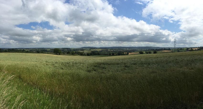
Note - Unless otherwise stated, all maps have been prepared @Crown copyright and
2   database rights [2019] Ordnance Survey Llangarron Parish Council (Licensee) License number
    OS PSMA number 100054540.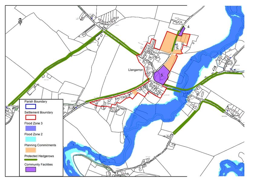
Contents
..................................................................................................................................................... 0
1.0         Introduction ................................................................................................................... 4
2.0         Plan Preparation .......................................................................................................... 6
3.0         Background and History of the Parish ...................................................................... 7
4.0         Vision and Objectives................................................................................................ 11
5.0         Planning Policies........................................................................................................ 13
6.0         Sustainability .............................................................................................................. 14
7.0         The Environment........................................................................................................ 17
8.0         Employment ................................................................................................................ 32
9.0         Housing ....................................................................................................................... 38
10.0        Roads and Traffic ...................................................................................................... 54
11.0        Community Facilities ................................................................................................. 58

                                                                                                                                                          Llangarron Parish Neighbourhood Plan 2021 - 2031
12.0        Communication .......................................................................................................... 63
13.0        Energy ......................................................................................................................... 65
14.0        Monitoring and Review ............................................................................................. 68
Appendix One.......................................................................................................................... 69
Glossary ................................................................................................................................... 70

                                                                                                                                                                                                             3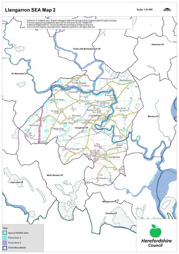
1.0 Introduction

                Map 1: Llangarron Parish Designated Neighbourhood Area and Parish Boundary

    1.1   The Llangarron Parish Neighbourhood Development Plan (NDP) is a new type of planning
          policy document. NDPs form part of the Government’s Localism agenda and are designed to
          help residents and stakeholders set out non-strategic (locally detailed) planning policies which
          will be used to shape development in their local area.
    1.2   Following on from a consultation on the Neighbourhood Plan area in September 2012, the
          Parish Council applied to Herefordshire Council for designation as a neighbourhood area on
          16th October 2012. The area was designated on 6th December 2012. The designated
          neighbourhood area is the same as the Parish boundary and is shown on Map 1.
    1.3   Building on subsequent public meetings, events and questionnaires, the Parish Council
          published a Draft Plan for formal consultation (Regulation 14) in 2017. However following
          consideration of the submitted responses, including those from Herefordshire Council which
          set out a number of concerns relating to the general conformity of the Draft Plan Policies with
          the adopted Local Plan Core Strategy 2011 - 2031, the Parish Council made the decision to
4         undertake a review of the NDP. The review process included a second Call for Sites and
          Technical Site Assessment process of submitted sites. The review also included a fresh look at
          the entire Draft Plan, covering its supporting text, Draft Policies, identified settlement
          boundaries and proposed site allocations.
1.4   The revised NDP was published for formal, Regulation 14 public consultation with local
      residents, stakeholders, landowners and consultation bodies from 1st September 2020 to 26th
      October 2020.
1.5   Neighbourhood Plans cannot be prepared in isolation. They have to have regard to national
      planning policy (as currently set out in the most up to date version of the National Planning
      Policy Framework, February 2019)1 and advice such as National Planning Practice Guidance2.
      NDPs also have to be in general conformity with the strategic planning policies of the local
      authority's development plan; here Herefordshire Council's adopted Local Plan Core Strategy
      2011 - 20313. In addition, there are various other 'basic conditions' against which the NDP
      will be tested at examination including contributing to the achievement of sustainable
      development and being compatible with EU obligations.
1.6   The plan has been prepared taking into account the key issues and objectives identified in the
      consultation process. Each key theme makes reference to both the NPPF and the Core
      Strategy.
1.7   The chapters and policies are not set out in order of importance and are not mutually

                                                                                                       Llangarron Parish Neighbourhood Plan 2021 - 2031
      exclusive. They should be read in conjunction with other policies in the Neighbourhood Plan.

                                                                                                                                                          5

      1
        https://www.gov.uk/government/publications/national-planning-policy-framework--2
      2
        https://www.gov.uk/government/collections/planning-practice-guidance
      3
        https://www.herefordshire.gov.uk/info/200185/local_plan/137/local_plan_-_core_strategy/2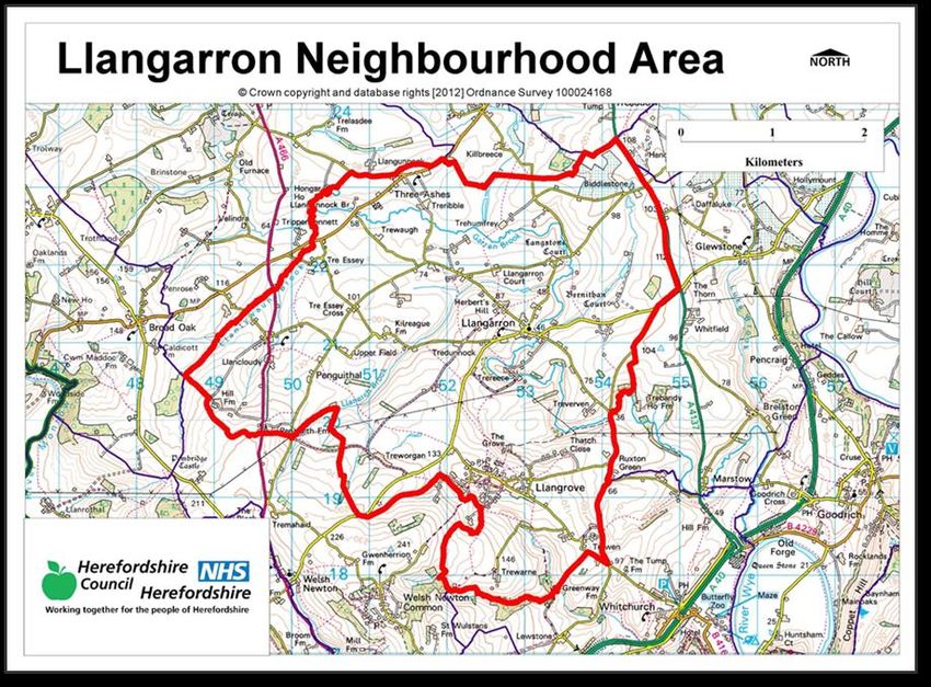
2.0 Plan Preparation
    2.1   This NDP has been prepared by Llangarron Parish Council. The Submission NDP has been
          revised and updated but it takes account of the earlier work of the former Neighbourhood
          Plan Steering Group, which included Parish Council members and residents. The Steering
          Group had significant help from community volunteers and from the dedicated
          Neighbourhood Planning Team at Herefordshire Council.
    2.2   The Steering Group was set up in January 2013 following consultation with the community in
          the form of two public meetings. An application for the designation of the Neighbourhood
          Plan Area was approved on 5th December 2012 and work commenced on a detailed
          consultation process which included:

             •   Initial questionnaires seeking the key issues

             •   Discussions with various community groups and associations

             •   A presentation to the local primary school

             •   A stand at the Llangarron Village Fete in July 2013

             •   A questionnaire to all households in the Parish and an invitation to a Neighbourhood
                 Planning for Real Event in November 2013

             •   An open day in November 2014 and follow up questionnaire relating to the Draft
                 Sustainability Statement, Draft Vision and Objectives

    2.3   These events were well attended and demonstrated an enthusiasm by the community to
          develop its own Neighbourhood Plan, which has at the heart of it the aims and objectives to
          keep the Parish a sustainable and thriving place to live and work.

6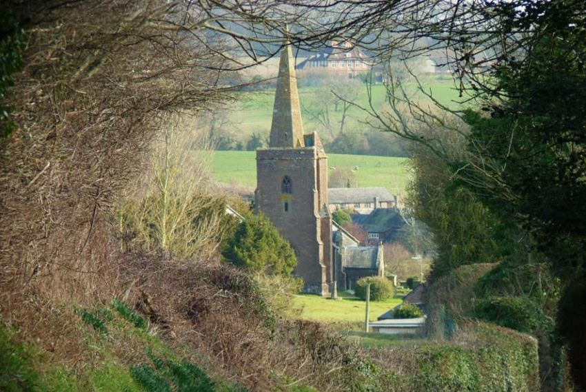
3.0 Background and History of the Parish
3.1   Llangarron Parish is a rural community of approximately 463 homes (Census 2011) mainly
      centred around the villages of Llangarron and Llangrove and nestling in picturesque
      Herefordshire countryside near the border with Monmouthshire. The parish also
      incorporates the hamlets of Llancloudy and Three Ashes as well as several smaller scattered
      individual dwellings and groups of houses.
3.2   The Parish is set in an area of attractive border countryside in the triangle formed by the
      market towns of Ross-on-Wye, Monmouth and the city of Hereford. The Wye Valley AONB
      lies just to the east. It offers an ideal combination of peaceful, rural life with amenities
      available approximately 6 miles from the thriving market towns of Ross-on-Wye and
      Monmouth. Both offer a good range of independent shops, supermarkets, primary and
      secondary schools and leisure facilities. The Cathedral cities of Hereford and Gloucester are
      approximately 13 miles and approximately 21 miles distance respectively.
3.3   Communications are excellent with the A40 dual carriageway running through Ross and

                                                                                                      Llangarron Parish Neighbourhood Plan 2021 - 2031
      Monmouth and connecting to the M50 and M4, thus providing fast access to the West
      Midlands, Bristol and South Wales. Hereford and Newport have mainline rail stations and
      nearby international airports include Birmingham, Cardiff and Bristol.
3.4   In the ancient past Llangarron Parish was part of Archenfield, a kind of no-man’s-land
      established in the 9th century with its own laws and customs, where Welsh and English were
      spoken. The Parish takes its name from Llangarron Village, an historic and important village.
      Suggestions about the name Llangarron are that it is derived from "Llan" meaning place and
      "Garron" being the name of a tributary of the Wye which runs through the heart of the
      village. An alternative view is that the village is named after the Welsh word “garan” which
      means a heron, stork or crane. This may explain the representation of such a bird on the
      church gates.

                                                                                                                                                         7
                                     St Deinst Church gates in Llangarron
Llangrove
    3.5   Llangrove’s first mention was in 1372, when it was listed as Longegroue having one hundred
          acres of underwood to cut every nine years for charcoal. It was mainly common land, and the
          settlement pattern was similar to that of Llangarron though with fewer (seven) listed
          buildings.

                               Llangrove Village (Source: Views from Above, copyright)

    3.6   Christ Church is one of the listed buildings and was designed by the ecclesiastical architect
          George Frederick Bodley and endowed by Mrs Catherine Marriott, Lady of the Manor of
          Goodrich. Christ Church was opened in 1856 by which time the village was well established
          with two chapels, a pub and three shops. The school and adjacent master's house opened in
          1875, once again as a result of Mrs Marriott’s generosity
    3.7   The local traders included a wheelwright, boot and shoemaker, carpenter and blacksmith.
          Employment up to the early nineteen-hundreds was mainly on the farms or, for the women,
          in service at the big houses. By World War I the pattern was altering and jobs such as
          engineer, miner and signalman were listed.
    3.8   The present population is around 500 which enables the village to support its school, now
          called Llangrove CE Academy, and its pub The Royal Arms. The once thriving shops and post
          office no longer exist but Llangrove Village Hall is used almost every day and provides a focal
          point for entertainment and meetings in the village.
          Llancloudy
    3.9   Llancloudy is an ancient linear settlement at the western edge of the parish and lies within a
          couple of miles of the Welsh border. The A466 Monmouth to Hereford road runs through it
8         and provides a daily bus service. The turnpike house on the main road was converted in 1840
          to a Wesleyan Methodist chapel, reflecting the strong nonconformist tradition in the area.
          The chapel remains important in the village as the main meeting place for residents. At one
          time, there was a small church, administered from Llangarron, and a pub, The Bush, now long
          gone.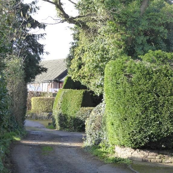
Llangarron
3.10 Llangarron is sometimes spelt Llangarren and was first mentioned in the 1086 edition of the
     Domesday Book. The village was well-settled by the 18th and early 19th centuries and was
     virtually self-sufficient by the late eighteen-hundreds. Kelly’s directories of the time list
     carters, farriers, plasterers, carpenters, bootmakers, coffin makers and millers. There were
     several working mills on the Garron, two pubs, at least two shops, a school and of course the
     ancient church.

                                                                                                       Llangarron Parish Neighbourhood Plan 2021 - 2031
                                              Llangarron Village

3.11 St Deinst Church is at the ‘heart’ of the village and is named after a Celtic saint who died in
     c584. Records of a church in Llangarron go back as far as Edward the Confessor, when a
     wooden church was consecrated. The current stone church was heavily restored in the 14th
     century and major work was undertaken in 1861 when a new aisle was added to the north to
     extend the seating capacity. More recently this aisle has been converted into a community
     space called The Garron Centre which was opened on Saturday 7th June 2014
3.12 There are two other significant listed buildings near Llangarron Village; Bernithan Court and
     Langstone Court, both of which were built at the beginning of the 17th Century. The
     importance historically of Llangarron is well documented with a total of over seventy listed
     buildings and structures including many tombs.

                                                                                                                                                          9
                           Langstone Court                         Bernithan Court
Three Ashes
3.13 Three Ashes is a dispersed small hamlet located in the north of the Parish on the boundary
bordering St Weonards Parish, with a population of around 80 residents. The B4521 from St
Owens Cross to the crossroads of the A466 (Hereford/Monmouth Road) runs through the
middle of the hamlet. The only significant historic building in Three Ashes is Treribble House,
which is on the southern edge of the hamlet and is a Grade II listed property built in 1721.
Other small clusters
3.14 The remainder of Llangarron Parish mainly comprises clusters of buildings often around farms
including Biddlestone, Langstone, Penguithal, Tredunnock, Tre Essy, Tre Evan, Trehumfrey,
Trereece and Treribble. Many of the farms and larger building have the prefix “Tre” which
means a farmstead.
Changes in the Parish
3.15 Over the years the Parish has seen many changes. In the 1950s and 60s increased
mechanisation of farming meant jobs on the land became scarce. However, village bus
services and increasing car ownership made local towns more accessible and people were
able to seek work over a wider area including in Ross, Monmouth, Hereford, even Gloucester
and the Forest of Dean. Hence the structure of the communities began to evolve. The M50
was opened in 1962 and the A40 dual carriageway in 1965, both of which gave easy access to
the Midlands, Bristol, Newport and Cardiff.
3.16 In the 1970s and 80s, with the advance of office and communication technology, there was
an increasing tendency for people to work or run businesses from home. The attraction of
living in an area like this and visiting a work-base in the city occasionally, brought new faces to
the Parish – slowly at first but increasing from the 1990s. The increase in homeworking in the
village was reflected in recent Census data. An expanding population has brought support for
village groups and clubs, new children for the school and pre-school, people volunteering to
serve on committees and offering their skills for many things including grant application and
other local projects.
3.17 The skills base of these people provides a wide range of local services including engineers,
plumbers, electricians, builders, carpenters, gardeners, chimney sweeps, computer support
specialists, upholsterers, medical and care services and many more alongside the thriving
agricultural community.
3.18 Llangarron Parish continues to retain its rural feel and the Neighbourhood Plan seeks to
maintain this whilst ensuring that the Parish continues to be a good place in which to live,
work and bring up a family. It is vital that the Parish continues to develop and that services
such as fast Broadband are fully available to enable people to live and work here. It is
important that support for village activities will continue to engender a lively and vibrant
sense of community.
104.0 Vision and Objectives
4.1 The visions and objectives set out below were developed following detailed feedback from a
questionnaire to all households in the Parish, a “Planning for Real” event and meetings with
various focus groups. These identified what the residents within the Parish considered to be
the main issues in developing the Neighbourhood Plan. As a result, the following vision
statement has been produced.
The Vision:
The Parish of Llangarron including the villages of Llangrove, Llancloudy, Llangarron and
Three Ashes will be a vibrant sustainable rural community, providing a high quality of life
for people who live and work in, and visit the parish.
During the plan period up to 2031 this Vision will be delivered through the following
Objectives:
Llangarron Parish Neighbourhood Plan 2021 - 2031
Objective 1 - Sustainability:
To promote the creation of balanced communities with sufficient housing, business
opportunities and facilities to satisfy all sectors of the community.
(To be delivered through Policy SUS1 and all other NDP Policies)
Objective 2 - Environment:
To manage and protect the countryside and heritage assets for all to enjoy, by providing
measures to protect and enhance the landscape setting and character of the villages including
conserving important heritage assets and protecting the wider countryside.
(To be delivered through NDP Policies ENV1, ENV2, ENV3 and ENV4)
Objective 3 - Employment:
To support existing businesses and to attract new employment opportunities in local
agriculture, food production and sustainable tourism opportunities, so that jobs are provided
close to where people live, and opportunities for homeworking are encouraged.
(To be delivered through NDP Policies EMP1 and EMP2)
Objective 4 - Housing:
To ensure the provision of sustainable, energy efficient housing in the Parish which is
appropriately designed to meet the needs of all sectors of the community. This will include
both private and affordable sectors. The scale, design and location of the dwellings should as
far as possible, reflect the character of the area and any new dwellings should be built to a
high standard of design.
(To be delivered through NDP Policies HOU1, HOU2, HOU3 and HOU4)
11
Objective 5 - Roads and Traffic:
To promote measures for pedestrian and cyclists’ safety and ensure there is no detrimental
impact on highway safety for all road users. Wherever possible the plan will encourage andsupport the use of public transport and roads, paths, drains etc will be maintained in good
condition.
(To be delivered through NDP Policy TRA1)
Objective 6 - Community Facilities:
To protect existing community facilities and assets and promote the improvement of services
and other facilities within the Parish such as footpaths, open space and play areas.
(To be delivered through NDP Policy CSU1)
Objective 7 - Communication:
To work effectively with the broadband supplier to encourage the development of faster
broadband and other means of communication within the Parish and so allow businesses to
operate and grow and the community to thrive.
(To be delivered through NDP Policy COM1)
Objective 8 - Energy:
To encourage the use of sustainable energy whilst seeking to ensure there is no detrimental
impact on the character of the area or the people who live in the Parish. New housing
schemes and other development will be encouraged to incorporate sustainable energy
efficiency.
(To be delivered through NDP Policies ENG1 and ENG2)
125.0 Planning Policies
5.1 The following policies have been developed as the means of delivering the key objectives and
the vision for Llangarron Parish. Each policy has been developed in the context of the
National Planning Policy Framework and the Core Strategy for Herefordshire and as a result of
the detailed consultation responses carried out with the people living and working in the
Parish.
5.2 The NPPF sets out in paragraph 29 that 'neighbourhood planning gives communities the
power to develop a shared vision for their area. Neighbourhood plans can shape, direct and
help to deliver sustainable development, by influencing local planning decisions as part of the
statutory development plan. Neighbourhood plans should not promote less development than
set out in the strategic policies for the area, or undermine those strategic policies.' The NDP
planning policies therefore have been prepared within the strategic planning framework of
Herefordshire Council.
5.3 The Policies have been revised and updated. This process included consideration of the
Llangarron Parish Neighbourhood Plan 2021 - 2031
representations submitted during the previous Regulation 14 public consulation process.
5.4 Whilst planning is predominantly about use and development of land and buildings, the
Neighbourhood Planning consultation process has raised other aspects of infrastructure
necessary to support a sustainable community. These are not included in the NDP as they are
largely non planning matters and are the responsibility of Herefordshire Council.
5.5 Once made, the NDP Planning Policies will form part of the statutory development plan. This
is very important as planning applications are determined in accordance with the
development plan unless material considerations indicate otherwise. Each policy should not
be read in isolation but in conjunction with other policies within this document. Where a
planning proposal does not fall within the scope of these policies the Herefordshire Local Plan
Core Strategy 2011 - 2031 will provide the planning policy framework. The NPPF is one of the
other material considerations.
13
Llangarron Countryside6.0 Sustainability
Objective 1:
To promote the creation of balanced communities with sufficient housing, business
opportunities and facilities to satisfy all sectors of the community.
Policy Justification
6.1 The National Planning Policy Framework sets out in paragraph 7 that 'the purpose of the
planning system is to contribute to the achievement of sustainable development. At a very
high level, the objective of sustainable development can be summarised as meeting the needs
of the present without compromising the ability of future generations to meet their own
needs.'
6.2 The NPPF goes on to say (in paragraph 8) that the planning system has three overarching
objectives, economic, social and environmental:
a) an economic objective – to help build a strong, responsive and competitive economy, by
ensuring that sufficient land of the right types is available in the right places and at the right
time to support growth, innovation and improved productivity; and by identifying and
coordinating the provision of infrastructure;
b) a social objective – to support strong, vibrant and healthy communities, by ensuring that a
sufficient number and range of homes can be provided to meet the needs of present and
future generations; and by fostering a well-designed and safe built environment, with
accessible services and open spaces that reflect current and future needs and support
communities’ health, social and cultural well-being; and
c) an environmental objective – to contribute to protecting and enhancing our natural, built
and historic environment; including making effective use of land, helping to improve
biodiversity, using natural resources prudently, minimising waste and pollution, and
mitigating and adapting to climate change, including moving to a low carbon economy.
6.3 Core Strategy Policy SS1 Presumption in favour of sustainable development sets out that
when considering development proposals Herefordshire Council will take a positive approach
that reflects the presumption in favour of sustainable development.
6.4 The results from the “Planning for Real” Event, the questionnaires and other community
consultation clearly demonstrated support throughout the Parish for future housing and
business development of a limited scale appropriate to the area.
6.5 It was felt that improvements to the infrastructure, especially roads and flooding, needed to
be carefully assessed and that any new development should not add to any further flooding
issues.
6.6 It was considered that limited development should take place in both Llangarron and
Llangrove. The responses to the housing element recognised the need for a balance in the
14
types of housing permitted in the villages.
6.7 Attracting new families and providing facilities and homes to retain young people in the
Parish was felt to be key.6.8 Protection of the environment was highlighted as a key issue and a high number of people
supported the use and provision of alternative forms of sustainable energy.
6.9 The retention and development of community facilities was considered key in maintaining the
future of the Parish. Hence the public consultation clearly demonstrated the view of the
community that sustainable development is about positive growth – making economic,
environmental and social progress for this and future generations.
6.10 Sustainability is the key thread running through the National Planning Policy Framework and
Policy SUS1 Sustainable Development provides an overarching framework to guide all
development proposals.
Policy SUS1: Sustainable Development
Development proposals will be required to demonstrate that they contribute to
sustainability and community resilience by addressing the following criteria:
1. Development proposals should conserve and enhance the natural and
Llangarron Parish Neighbourhood Plan 2021 - 2031
historic environment. Wherever possible existing trees and hedges should
be retained. This should be achieved through the design and delivery of
high quality built environment and landscaping schemes which respond
positively to local distinctiveness and rural character;
2. Proposals should minimise reliance on the private car by promoting
walking and cycling and where possible being located close to local bus
services, whilst recognising that for rural communities the car is likely to
remain an important mode of transport for many households;
3. Development proposals should enhance and maintain the vitality of local
communities by supporting local and essential services;
4. New residential development should be located within the identified
settlement boundaries of Llangrove, Llancloudy, Llangarron and Three
Ashes and should contribute to a suitable mix of housing in terms of type,
size and tenure to promote strong, balanced communities, and in
particular meet the needs of young families, the elderly and people with
disabilities. The precise housing mix should address the changing needs of
the parish over the plan-period in order to support local community and
economic wellbeing;
5. Outside these settlements development will be considered to be in
Herefordshire's countryside and will be required to comply with
Herefordshire Local Plan Core Strategy Policies RA3, RA4 and RA5;
6. Development should ensure there is no detrimental impact on essential
15
infrastructure by:
i. Minimising the risk of flooding for existing and new properties
by promoting and delivering measures to reduce flood risk; andii. Undertaking works to upgrade the shortfalls in the capacity of
other infrastructure including, utilities, waste water and land
drainage.
7. Any new development should minimise the impact on the local roads and
surrounding highway network by:
i. Introducing traffic calming measures where appropriate to
minimise the impact on local amenity and improve pedestrian,
equestrian and cyclist safety; and
ii. Promoting sustainable transport initiatives.
8. Small scale employment related development should support the local
economy, while retaining the area’s unique character.
9. Development which supports opportunities for working from home will be
supported.
167.0 The Environment
Objective 2:
To manage and protect the countryside and heritage assets for all to enjoy, by providing
measures to protect and enhance the landscape setting and character of the villages
including conserving important heritage assets and protecting the wider countryside.
Policy Justification:
7.1 Paragraph 170 of the NPPF sets out that 'planning policies and decisions should contribute to
and enhance the natural and local environment by:
a) protecting and enhancing valued landscapes, sites of biodiversity or geological value;
b) recognising the intrinsic character and beauty of the countryside, and the wider benefits
from natural capital and ecosystem services – including the economic and other benefits of
the best and most versatile agricultural land, and of trees and woodland;
Llangarron Parish Neighbourhood Plan 2021 - 2031
d) minimising impacts on and providing net gains for biodiversity, including by establishing
coherent ecological networks that are more resilient to current and future pressures;
e) preventing new and existing development from contributing to, being put at unacceptable
risk from, or being adversely affected by, unacceptable levels of soil, air, water or noise
pollution or land instability. Development should, wherever possible, help to improve local
environmental conditions such as air and water quality, taking into account relevant
information such as river basin management plans; and
f) remediating and mitigating despoiled, degraded, derelict, contaminated and unstable land,
where appropriate.'
7.2 Paragraph 118 sets out that 'planning policies and decisions should: c) give substantial weight
to the value of using suitable brownfield land within settlements for homes and other
identified needs.'
7.3 Local Plan Core Strategy Policy LD1 Landscape and Townscape requires development
proposals to demonstrate that the character of the landscape and townscape has positively
influenced design and Policy LD2 Biodiversity and Geodiversity requires development to
conserve, restore and enhance biodiversity and geodiversity assets.
7.4 Policy LD3 Green Infrastructure requires development to protect, manage and plan for
existing and new green infrastructure.
Landscape and Biodiversity
7.5 Llangarron Parish is identified in the Herefordshire Landscape Character Assessment 2004 as
being characterised as wooded hills and farmlands. The key characteristic of the area is varied
sloping topography with visually prominent field boundaries interspersed with some
woodland and with mixed farming uses. Settlements in these landscapes are typically
17
clustered dwellings, associated with the areas of open fields. Small villages and hamlets are
dispersed through the associated landscape.
7.6 The Parish lies on the south-western side of the County and is bounded to the east by the
Wye Valley Area of Outstanding Natural Beauty. There are no Sites of Special ScientificInterest (SSSIs) within the Parish. However, there are 3 Special Wildlife Sites which border
the Parish - Upper and Lower Heath Woods, Nantywain Wood and woodland at Welsh
Newton and Common hill. Also on the border are three identified Ancient Woodlands at
Trebandy Wood, St Wolstans Wood and Nantywain Wood. The River Wye lies 1.6 km to the
south east. Special Wildlife Sites are shown on Llangarron Map SEA Map 2, reproduced as
Map 2 in the NDP. Tretawdy Nature Reserve is a Local Wildlife Site.
Map 2: Llangarron Map SEA Map 2
187.7 Agricultural land classification is mainly Grades 2 and 3 (good to moderate) but with some
Grade 1 in the north east of the parish. It is important ensure that the best and most versatile
agricultural land is protected from development.
7.8 It was evident from consultation responses that residents in the Parish value the landscape in
which they live and work. The responses to the questionnaire and the information from the
“Planning for Real” Event highlighted the importance people give to the environment they
live and work in.
• 60% of respondents favoured positive management of the local environment
• 50% of respondents favoured encouraging varied local wildlife
• 46% of respondents favoured greater protection of historic and natural features
• 25% of respondents favoured increased provision of green space
7.9 Respondents also highlighted the importance of retaining the open nature and countryside,
the setting of the villages and making sure any detrimental impacts of new development are
Llangarron Parish Neighbourhood Plan 2021 - 2031
minimised. People also recognised the importance of open spaces and footpaths and put
forward suggestions regarding the maintenance of and improvement to public footpaths in
the parish.
7.10 The Parish Council has identified the following views as important in the neighbourhood area:
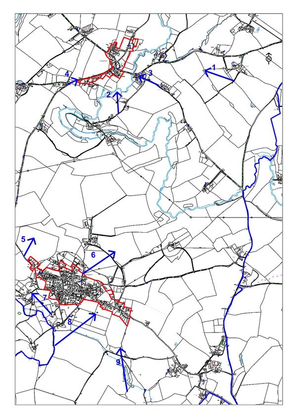
Figure 1 - Llangarron Important Views
View View 1: View from a footpath at Little View 2: View from the lane at Upper
Bernithan towards Llangarron Trereece towards the Church and Herberts
(Number 1 on Map 3) Hill (Number 2 on Map 3)
View
View 3: View from the lane behind The View 4: View of the Church approaching the 19
Three Horseshoes towards the Church village on the Llangrove Road
(Number 3 on Map 3) (Number 4 on Map 3)View 5: View from GR525194. Llangarron is
visible in the valley below (the church spire is
visible) and white houses on the RHS are at
Parkmill (Number 5 on Map 3)
Llangrove
7.11 There were several responses to the Regulation 14 consultation suggesting that
additional views should be identified around Llangrove. The following important
views were identified for inclusion in the NDP, following a further request by the
Parish Council for proposed important views:
Figure 2 - Llangrove Important Views
View 7: From footpath LG29 looking towards
View 6: From footpath LG43 Looking north north west Llangrove.
east away from Llangrove. (Number 7 on Map 3)
(Number 6 on Map 3)
20 View 8: From footpath LG28 looking from View 9: From footpath LG13 Woodland path
south towards Llangrove and beyond. leading to Llangrove.
(Number 8 on Map 3) (Number 9 on Map 3)Map 3: Important Views
Llangarron Parish Neighbourhood Plan 2021 - 2031
217.12 At the former Regulation 14 consultation Natural England suggested that the NDP should
include a specific policy commitment to the preservation, and restoration, of existing green
infrastructure, for example, trees, hedges, woodland and the creation of habitat as a resource
for the community, for example, traditional orchards. This has also been included in Policy
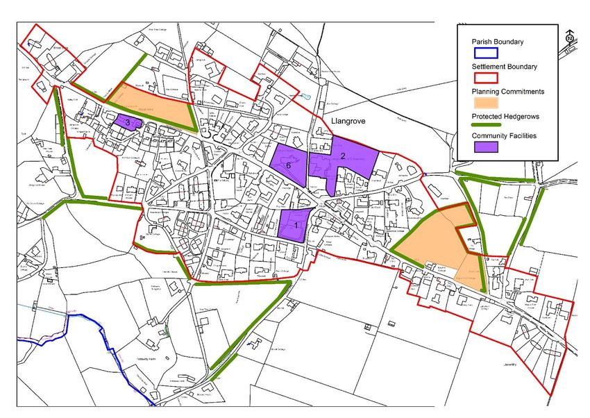
ENV1. Important traditional hedgerows are identified on the Policies Maps (Maps 4, 5, 6 and
7). These contain a range of local species and have been in existence for many years. These
were identified from old local maps and frequently follow historic road and field boundaries.
There are no streetlights in any of the settlements and residents enjoy a ‘Dark Skies’
environment. New buildings should be sensitive to the need to protect the dark skies.
Policy ENV1: Landscape and biodiversity
New proposals for development should seek to protect and enhance the
landscape character and biodiversity of the Parish. In order to protect the
landscape character new proposals should positively enhance the existing
landscape and minimise their impacts on:
1. Important views, including but not limited to, visually sensitive skylines,
valley sides and hillsides as shown on Maps 3A and 3B;
2. Nocturnal character including dark skies, from light pollution;
3. Hedgerows (see Polices Maps 4, 5, 6 and 7), unregistered parks and
gardens and ancient woodlands;
4. Public open spaces and footpaths;
5. Veteran, ancient, mature and notable trees and existing traditional
orchards; and
6. Waterways and tributaries of the River Wye.
Development proposals should demonstrate how they have addressed the
preservation, and restoration, of existing green infrastructure, for example, trees,
hedges and woodland. Wherever possible development should support the
creation of new habitats, for example by planting orchards as part of biodiversity
net gain and as a resource for the community. Traditional hedgerows should be
retained a boundary treatments and new hedgerows should use appropriate local
species which enhance biodiversity.
'Traditional orchards should be retained unless it can be demonstrated that their
loss will not reduce environmental biodiversity or be detrimental by causing loss
of wildlife habitat. Where orchards are lost developers can be expected to include
an equivalent range of varietal fruit species traditional to the local area in
landscaping schemes of at least equivalent size to that which will be lost or
provide a new orchard using traditional species for the benefit of the local
community.
22 The priority for new development should be to avoid direct and indirect impacts
upon landscape character and biodiversity. Where impacts cannot be avoided,
mitigation and then compensation measures should be provided.Llangarron Countryside
Llangarron Parish Neighbourhood Plan 2021 - 2031
Historic Buildings and Conservation
7.13 Paragraph 185 of the NPPF sets out that 'plans should set out a positive strategy for the
conservation and enjoyment of the historic environment. This strategy should take into
account:
a) the desirability of sustaining and enhancing the significance of heritage assets, and putting
them to viable uses consistent with their conservation;
b) the wider social, cultural, economic and environmental benefits that conservation of the
historic environment can bring;
c) the desirability of new development making a positive contribution to local character and
distinctiveness; and
d) opportunities to draw on the contribution made by the historic environment to the
character of a place.'
7.14 Herefordshire Local Plan Core Strategy Policy LD4 Historic Environment and Heritage Assets
requires proposals 'to protect, conserve and where possible enhance heritage assets and their
settings in a manner appropriate to their significance'.
7.15 There are 78 listed buildings and scheduled monuments in Llangarron Parish including Grade
II* Ruxton Court, Bernithan Court, Langstone Court, Grade I Listed Church of St Deinst and
Grade II Listed Christ Church4.
7.16 Whist there are no registered historic parklands in the parish, there is an unregistered park
and garden at Langstone Court that is considered to be of significant local importance and
should be protected.
23
4
https://historicengland.org.uk/listing/the-list/7.17 The consultation sought to identify which buildings, places or views that it was considered
important to protect and it was evident that respondents felt strongly about protecting views
of both the landscape and buildings in the area. These included:
• St Deinst Church Llangarron
• Christ Church, Llangrove
• Bernithan Court
• Langstone Court
• Historic buildings and monuments in general.
The view to St Deinst church/Llangarron was by far the most frequent response.
St Deinst Church, Llangarron
7.18 These buildings play a significant role in the character of the Parish and are visually
recognised as key landmarks in the area. Policy ENV2 should help to ensure any new
development does not have a detrimental impact on the setting or character of heritage
assets.
7.19 The Parish Council will work with Herefordshire Council to produce a list of locally important
Heritage Assets.
7.20 Each settlement has a distinctive local character.
24Llangrove
Llangrove - typical residential lane Llangrove village, view from west, FP LG28
Llangarron Parish Neighbourhood Plan 2021 - 2031
Listed converted barns, Llangrove New housing, Llangrove
Records are scant, but in its current recognisable form Llangrove started coming together in
the late 1700s when smallholders built houses on what was then common land. Built of local
stone, often rendered, these modest cottages are spaced well apart and frequently set at
right angles to the road. They can still be seen dotted throughout the village, particularly at
the eastern end, and with their separating hedgerows and low ridge heights are still the most
defining feature of traditional Llangrove vernacular building.
Little building then occurred until the 1950s, since when reasonable amounts of new houses
have been built. Many of these dwellings are set back from the main road with a variety of
hedging and fencing along the boundaries. There are a number of small cul-de-sacs and
private roads leading to clusters of development. The buildings are predominantly detached 25
and are single or two storeys. A recent contemporary development by the Royal Arms Public
House which is two and a half storeys, dominates the adjacent Royal Arms Public House
which is a potential undesignated heritage asset. There has been much concern about the
scale of these dwellings in relation to the rest of the village and parishioners are keen toensure that any new development is kept at two storeys or below and the scale responds to
the village's existing character. Any new development should include suitable boundary
proposals including reinstating any lost hedging.
Llancloudy
The small settlement of Llancloudy has developed along the A466 with its centre considered
to be the cluster of dwellings around the Chapel. The dwellings are predominantly detached,
and the majority are single or one and a half storey. These properties sit in good sized plots
and are screened from the road by mature hedges. This is a loose knit, scattered settlement.
In terms of materials many of the properties are of white render with slate or clay tiled roofs,
although there are a few dwellings constructed with brick or stonework. The Chapel is a
modest single storey rendered building immediately adjacent to the road and is considered to
be a potential undesignated heritage asset. It is considered that any new development in
Llancloudy should reflect the prominent characteristics of single or one and a half storey
dwellings. Any new development should include suitable boundary proposals including
reinstating hedging.
Llangarron
Local sandstone houses with outlook towards open St Deinst Church 12th Century
countryside and farmstead buildings in local sandstone Grade I Listed Church in local sandstone
26
Typical local cottages in rendered sandstone and The Old School House in the centre of the village,
walls constructed of local sandstone sandstoneHistorically the village of Llangarron has grown up around the medieval Church of St Deinst (a
Grade I listed building). There are two listed buildings within the centre of the village but
many surrounding properties are considered to be potential undesignated heritage assets,
including Trecilla House and its surrounding outbuildings, now converted into dwellings and
the Old School House also now a dwelling. These are constructed of local sandstone which is
also the traditional building material used in surrounding farmsteads. There is a cluster of
traditional dwellings close to the bridge.
The dwellings in the centre of the village comprise a range of traditional styles of varying
materials and sizes including stone and render, the majority with slate roofs. There are
several more contemporary twentieth century dwellings close to the telephone exchange.
The approach to the village in all directions is dominated by high hedges and these are
recognised as an important characteristic of the village. Several of the properties have high
stone walls which add character to the village and should be retained. Any new development
should take reference from these characteristics including scale and the use of levels to
ensure the historic centre of the village is retained and no new development dominates the
Llangarron Parish Neighbourhood Plan 2021 - 2031
skyline. Any new development should include suitable boundary proposals including
reinstating hedging.
Llangarron has a number of historic stone walls which define the village centre. These include
around St. Deinst Church where the walls are obscured by ivy, around the old school
playground and high stone walls around Trecilla House and Court.
Three Ashes
Three Ashes is a very small, fragmented settlement built around the B4521. The approach to
the settlement is one of large arable fields behind roadside hedges. The existing properties
are predominantly single or one and a half storey and built in the twentieth century.
Materials are redbrick and render with a mixture of roof types. These generally sit within
large plots. It is expected that any new development should reflect both the scale and
openness of the area. Any new development should include suitable boundary proposals
including reinstating of hedging
7.21 Policy ENV2 aims to protect local heritage and character in the Parish by requiring
development to be sensitive to the historic environment and to incorporate traditional details
and materials.
Policy ENV2: Protecting historic assets and settlement
character
Development proposals should:
1. Not adversely affect Listed Buildings, important landscapes and features,
27
and buildings considered to be of local architectural, or historic interest
which contribute to the character of the villages within the Plan area.2. Pay special attention to the need to conserve and enhance such buildings
or sites, their setting and any significant architectural, historic and
landscape features.
3. Not adversely affect settings of heritage assets which are valued by
residents. These include but not limited to:
• St Deinst Church, Llangarron;
• Christ Church, Llangrove;
• Bernithan Court, Llangarron;
• Langstone Court and its associated unregistered park and garden;
• Treribble, Three Ashes .
4. Preserve the character of each village particularly by using designs and
building materials for new development which respect local building
tradition, features and distinctiveness. Schemes should respond to the
height and scale of nearby buildings and new buildings should not exceed
2 storeys. The use of traditional Herefordshire red sandstone and render
with painted window frames preferred. Schemes which contribute to
light pollution should be avoided.
5. Protect the setting of villages and the character of the open countryside
by locating new development within the settlement boundaries, unless
there is special justification as identified elsewhere in the plan, for
example for agriculture or tourism proposals.
6. Take account of known surface and sub-surface archaeology and ensure
unknown and potentially significant deposits are identified and
appropriately considered during development. Lack of current evidence of
sub-surface archaeology is not proof of absence.
Flooding
7.22 The Parish has suffered from flooding issues in the past and floods have been exacerbated by
the excessive rainfall of the last few years. Climate change is recognised as a key threat with
the potential for increased rainfall as a result of global warming.
7.23 Paragraph148 of the NPPF sets out that 'the planning system should support the transition to
a low carbon future in a changing climate, taking full account of flood risk and coastal change.
It should help to: shape places in ways that contribute to radical reductions in greenhouse gas
emissions, minimise vulnerability and improve resilience; encourage the reuse of existing
resources, including the conversion of existing buildings; and support renewable and low
carbon energy and associated infrastructure.'
28 7.24 Herefordshire Local Plan Core Strategy Policy SD3 sets out that 'measures for sustainable
water management will be required to be an integral element of new development in order to
reduce flood risk.'7.25 The village of Llangarron suffers from flooding of the Garron Brook during heavy periods of
rain resulting all roads to and from the village being blocked off, some residents being cut off
and other dwellings being accessible only by 4WD vehicles. There are problems of runoff and
associated pollution from farmland and regular flooding events in Biddlestone and the centre
of Llangrove.
7.26 Run-off water from the surrounding land, small streams and drainage ditches results in
further flooding around the Parish and causes severe damage to the structure of the roads. In
extremely wet weather some areas are only accessible by four-wheel drive vehicles.
Therefore, it is important to ensure that there is no increase in flooding as a result of new
development and that policies are in place to manage the existing problem.
7.27 The centre of Llangarron lies within an area identified as flood zone 2 and 3 which limits the
type of development which can take place. Policy ENV3 aims to ensure new development is
located in areas at low risk of flooding and that suitable mitigation measures are put in place
to minimise a development's contribution to increasing flood risk elsewhere.
Llangarron Parish Neighbourhood Plan 2021 - 2031
Policy ENV3: Flooding
Development proposals should be located in areas at low risk of flooding wherever
possible. Development proposals in Flood Zones 2 and 3 will be subject to the
Sequential Test and (where appropriate) Exception Tests in accordance with
National Policy. Proposals also should have regard to the Strategic Flood Risk
Assessment for Herefordshire (SFRA).
1. Where the management of surface water drainage needs to be addressed,
developers should utilise sustainable drainage systems (SUDS) where this is
practicable.
2. Development on all sites should be accompanied by detailed drainage proposals
setting out the approach to foul drainage, storm water, SUDs and any proposed
flood alleviation, and infrastructure improvements including permeable surfaces,
and how these will be delivered effectively.
3. Existing utility infrastructure should not be compromised, and mechanisms should
be put in place to avoid or mitigate any possible pollution.
Wastewater Treatment and Water Quality
7.28 During the first Regulation 14 public consultation Welsh Water commented that there is no
specific reference to the capabilities of the public sewerage system or wastewater treatment
works (WwTW) to accept the foul flows from the amount of new development proposed.
Consequently, it was recommended that a policy (in line with Policy SD4 of the Herefordshire 29
Council Core Strategy) should be considered for inclusion as this would provide the assurance
that new development will only be permitted where the capacity of the public sewerage
network and/or WwTW allows.7.29 In relation to development proposals in the settlements, Welsh Water also commented the
following:
• Llangrove is served by our Goodrich Wastewater Treatment Works (WwTW) for
which there are no issues in accommodating the level of growth proposed.
• Llangarron has no public sewerage within close proximity of the former proposed
sites. As such, it is likely that alternative foul drainage methods will be required in line
with Policy SD 4 of the Herefordshire Core Strategy. The Environment Agency (EA) can
provide more information on this.
• The Herbert’s Hill and Garron View areas of Llangarron are each served by a small (in
area) public sewerage network and WwTW. Off-site sewers may be required.
Otherwise, alternative foul drainage methods will be required in line with Policy SD 4
of the Herefordshire Core Strategy. The EA can provide more information on this.
• The public sewerage network in Llancloudy is very small in terms of area served. If
dwellings are located in proximity to the public sewerage network and WwTW there
will be no issues in accommodating though off site-sewers may be required.
Otherwise, alternative foul drainage methods will be required in line with Policy SD 4
of the Herefordshire Core Strategy. The EA can provide more information on this.
• There are no public sewers or WwTW in Three Ashes, therefore the provisions of
Policy SD 4 of the Herefordshire Core Strategy will need to be adhered to. The EA can
provide more information on this.
• None of the proposed former sites had issues with the supply of water.
7.30 In addition at the former Regulation 14 public consultation Natural England submitted
comments noting that Llangarron Neighbourhood Plan Area is in the catchment of the River
Wye. The River Wye is designated as the River Wye Special Area of Conservation (SAC). This
means that it is afforded protection under the EC’s Conservation of Habitats and Species
Regulations 2010, as amended (the ‘Habitats Regulations’). The rivers are also notified at a
national level as Sites of Special Scientific Interest (SSSI). The River Wye SAC has a series of
water quality targets associated with its good condition. The targets for phosphates are being
exceeded on some stretches of the river, while on other stretches future development has
the potential to result in failures. In order to ensure the river achieves its targets, a Nutrient
Management Plan (NMP) has been produced.
7.31 The NMP has been used to inform the adopted Herefordshire Core Strategy - see Core
Strategy Policy SD4: Waste water treatment and river water quality and its supporting text.
7.32 Natural England suggested that the NDP should include a policy requirement for new
development not connected to mains sewerage, and using septic tanks and packaged
treatment plants, to include measures such as soakaway or reed bed system, where
conditions allow, to reduce environmental impacts of effluent.
7.33 Policy ENV4 has therefore been included in the NDP following the recommendations of Welsh
Water and Natural England.
30Policy ENV4: Public sewerage network and wastewater
treatment works (WwTW)
Development that may result in the capacity of the public sewerage network
and/or the wastewater treatment works (WwTW) serving the Parish becoming
overloaded will not be permitted.
In either of these instances, development will need to be phased or delayed until
capacity becomes available, either through Welsh Water regulatory investment
or, in advance of this through the developer funding the improvements
themselves via the provisions of the Water Industry Act (1991) and/or section 106
of the Town and Country Planning Act (1990).
New development not connected to mains sewerage, and using septic tanks and
packaged treatment plants, should include measures such as soakaway or reed
bed systems, where conditions allow, to reduce environmental impacts of
Llangarron Parish Neighbourhood Plan 2021 - 2031
effluent.
318.0 Employment
Objective 3:
To support existing businesses and to attract new employment opportunities in local
agriculture, food production and sustainable tourism opportunities, so that jobs are
provided close to where people live, and opportunities for homeworking are encouraged.
The Royal Arms Public House, Llangrove
Policy Justification:
8.1 NPPF identifies an economic objective as one of the three overarching objectives to achieving
sustainable development (paragraph 8). Paragraph 80 goes on to say that 'planning policies
and decisions should help create the conditions in which businesses can invest, expand and
adapt'. Paragraph 83 sets out that in rural areas, 'planning policies and decisions should
enable:
a) the sustainable growth and expansion of all types of business in rural areas, both through
conversion of existing buildings and well-designed new buildings;
b) the development and diversification of agricultural and other land-based rural businesses;
c) sustainable rural tourism and leisure developments which respect the character of the
countryside; and
d) the retention and development of accessible local services and community facilities, such as
local shops, meeting places, sports venues, open space, cultural buildings, public houses and
places of worship.'
8.2 Herefordshire Local Plan Core Strategy Policy RA5 Re-Use of rural buildings supports the
32 sustainable re-use of rural buildings which make a positive contribution to rural businesses
and enterprise and Policy RA6 Rural economy supports proposals which help diversify the
rural economy. The Core Strategy seeks to support continuing economic growth, particularly
in areas which allow for the diversification of existing farm uses either through foodYou can also read