Safety First Improving hazard resilience in the Bay Area - MARCH 2020 - SPUR
←
→
Page content transcription
If your browser does not render page correctly, please read the page content below
Safety First
Improving hazard resilience in
the Bay Area

MARCH 2020
This report is a component of the SPUR
Regional Strategy, a vision for the future of
the San Francisco Bay Area

spur.org/regionalstrategy

The SPUR Executive Board adopted this paper as official SPUR
policy on December 3, 2019.

Acknowledgements

Authors:
Laura Tam and Laurie A. Johnson

Maps:
Beki McElvain

Additional research assistance:
Kathryn Exon-Smith and Jena Metwalli

Edited by Karen Steen
Designed by Shawn Hazen
Copy edited by Valerie Sinzdak
Cover photo by Sergio Ruiz

Thank you to the funders of the SPUR
Regional Strategy:
Chan Zuckerberg Initiative
Clarence E. Heller Charitable Foundation
Curtis Infrastructure Initiative
Dignity Health
Facebook
Genentech
John S. and James L. Knight Foundation
Marin Community Foundation
George Miller
Sage Foundation
Silicon Valley Community Foundation
Stanford University

Additional funding provided by AECOM,
Fund for the Environment and Urban Life,
Hellman Foundation, Microsoft, the Seed
Fund and Stripe.
3

Contents
Executive Summary                  0
Introduction                       0

1. Hazards and Vulnerability        8

2. How California Manages
   and Governs Hazard Resilience   20

3. Policy Recommendations
   and Discussion 		               28

Conclusion                         46
4

Executive
Summary

We all want and deserve to be safe in our homes and communities. Yet for those of us who live and work in
the San Francisco Bay Area, our home is a paradox. The Bay Area is both a treasured place and a hazardous
environment where flooding, wildfires and earthquakes are common today. These hazards are likely to be-
come more frequent, larger and more damaging in the future as climate change puts the region’s people, built
environment and natural habitats at risk. Without mitigation, the impact of these hazards will only increase as
the region grows. This impact could disproportionately affect those who are more exposed and vulnerable to
various risks — and who may have fewer resources to help them cope.
  This report builds on SPUR’s work in earthquake and climate resilience over the last 10 years and supports
the SPUR Regional Strategy, a 50-year vision for how the Bay Area of 2070 can be more equitable, sustainable
and resilient. The recommendations in this report address two key questions:

1. How can we mitigate risk from hazards and secure safety as the Bay Area adds people, jobs and housing
  over the next 50 years?
2. As a region exposed to multiple natural hazards, what can we do together to improve community resilience
  that we cannot achieve as individual cities and counties acting alone?

This report characterizes the Bay Area’s changing risks from floods, fires and earthquakes and describes the
potential equity impacts of worsening hazards. It also looks at how the region manages hazards today. SPUR
found that most of the policy tools the region has to manage hazards and assure safety are not designed for
changing risks or for a growing urban and interdependent region. One community’s actions to increase resil-
ience — or its failure to act — can affect its neighbors and the region as a whole. How one community prepares
for wildfire affects the fire safety of all adjacent communities. What one community chooses to do about
earthquake-vulnerable buildings and infrastructure affects surrounding neighborhoods and the economy. How
one community alters its shoreline to manage sea level rise affects flooding for its neighbors. Failing to plan
regionally means that resilience investments might not have the expected payoff or safety benefits, or they
might not improve conditions for the community at large.
  SPUR makes 12 policy recommendations for how the Bay Area can improve data and information gather-
ing, codes and standards, community planning and funding for multi-hazard resilience. Each recommendation
includes a longer discussion about why it’s necessary, how it might be implemented and who is responsible for
doing so.
5

Policy Recommendations:

1. Develop dynamic, web-based maps that reflect current and potential future property risk across multiple
   hazards.
2. Adopt a statewide functional recovery building standard so that more buildings will be usable and easily
   repaired after a disaster.
3. Require cities and counties to inventory and screen buildings for vulnerability to wildfires, flooding and
   earthquakes in areas of known risk. Make certain retrofits mandatory within 20 years.
4. Create a regional lifelines council to identify interdependencies between utility systems, assess their vulner-
   ability to hazards, set regionwide mitigation priorities and identify ways to fund critical upgrades within the
   next 10 years.
5. Consolidate certain single-purpose special districts (such as fire or flood prevention) into multi-hazard
   resilience districts and expand their geography as needed.
6. Develop local disaster recovery frameworks in every city and county to help ensure that local jurisdictions
   are ready to manage recovery following a major disaster.
7. Change zoning codes to prevent further development in high-hazard areas that are significantly vulnera-
   ble to fire, liquefaction and sea level rise, with priority consideration in those areas where multiple hazards
   overlap. Ensure no net loss of planned housing by accommodating new development in low-hazard existing
   urbanized areas.
8. Acquire undeveloped hazard-prone lands for public ownership and use.
9. Develop a regional or state buyout program for properties repeatedly damaged by wildfire, flooding or
   other climate impacts.
10. Ensure that insurance for fire, earthquake and flood hazards remains available and affordable for residents
   and businesses. Ensure that state insurance regulations encourage and appropriately price resilient land
   use, new construction and retrofit practices.
11. Establish a regionwide geologic hazard abatement district, or a series of countywide districts, to pool re-
   sources to fund regional resilience projects.
12. Establish a regional resilience trust fund for future climate adaptation and hazard management needs.

  The recommendations are directed at state, regional and local agencies because better hazard resilience is
a function across all scales of governance. We conclude with a call to action at all of these scales to invest in
better understanding, planning and implementation to create a safer Bay Area for everyone who is already
here and everyone who is yet to come.
6

Introduction
We all want and deserve to live in a safe place. Safety underpins all human needs and ambitions: raising fam-
ilies, going to work and school, running businesses, having fun with friends, sleeping soundly at night. Safety
from natural and unnatural disasters is often not at the forefront of our minds as we conduct our daily lives.
But when safety fails, it pulls what’s important into sharp focus: Without safety, we can’t go about our normal
activities — sometimes for a very long time. Collectively, we need safety for strong communities, physical and
mental health, economic security and prosperity, and a smoothly functioning society.
  The Bay Area’s mild climate and signature geographical features — wide river valleys, coastal bluffs and
beaches, a shallow bay, steep and forested hillsides — make this area ecologically rich and, for many of us, an
extremely desirable place to live. But these features also indicate great dynamism, where things are in motion
and the landscape can change quickly.
  And it does change. The Bay Area is exposed to natural and human-driven hazards, including flooding, wild-
fire, earthquakes, tsunamis, landslides, extreme heat, poor air quality and sea level rise. Flooding and wildfire
occur periodically today, but as the climate changes, they will become more frequent, more severe and longer
in duration. Sea level rise threatens our long coastline with permanent flooding. Small and moderate earth-
quakes occur sporadically today, but larger, much more serious earthquakes have a high likelihood of hap-
pening in our lifetimes. Our region’s built and natural environments — and our safety — are at risk from these
growing threats. Without mitigation, the impact of these hazards will only increase as the Bay Area adds more
people, housing and jobs.
  Some of these problems are worse today because of choices made in the past. For example, cities once used
the Bay as a landfill site and a place to build, because the region didn’t have a better system for managing
waste or for protecting the Bay. Now, many neighborhoods built on low-lying land near the Bay shore are only
a few feet above high tide, where they are vulnerable to sea level rise, rising groundwater and the liquefaction
caused by earthquakes. Filling the Bay also reduced ecological richness and diminished the free natural flood
protection provided by the wetlands and marshes that once lay between tidal areas and higher ground. Our
earthquake risk is largely a function of now-obsolete technologies used in our buildings and infrastructure.
While these structures were built with the accepted practices of their time, many of those practices are now
widely recognized as risky, and we have been slow about addressing them. In another example of how human
decision-making has increased risk, local governments have allowed development to progress into the region’s
forested areas, which are prone to wildfires. Many of these communities have few evacuation routes. And of
course, global climate change — a force multiplier — is caused by people and worsens every day with inaction.
Our world’s inability or unwillingness to act quickly to reduce emissions will continue to worsen climate-related
hazards, and thus the risks of living in the Bay Area.
  We can do something about this. While we cannot prevent certain hazards, we don’t have to accept wors-
ening damages, community disruption, injuries and deaths as the price of living here. We can correct mistakes
made in the past. It is the job of government to protect people to the extent that science and tools such as
land use planning, building codes and emergency response allow; government has a special obligation to
address issues that require collective action, ones that individuals cannot address themselves. Preparing for
climate change, correcting past development practices and other risk mitigation will not come cheap or easy
7

— but inaction will be far more costly. The full cost of disasters is much more expensive than investing in pre-
vention and mitigation.1
  This report builds on SPUR’s work in earthquake and climate resilience over the last 10 years and supports
the SPUR Regional Strategy, a 50-year vision for how the Bay Area of 2070 can be more equitable, sustainable
and resilient. The recommendations in this report answer two key questions:

1. How can we mitigate risk from hazards and secure safety as the Bay Area adds people, jobs and housing
   over the next 50 years?
2. As a region exposed to multiple natural hazards, what can we do together to improve community resilience
   that we cannot achieve as individual cities and counties acting alone?

1
  The National Institute of Building Sciences’ 2017 study found that every $1 spent on hazard miti-
gation saved on average $6 in future disaster costs: https://www.nibs.org/page/mitigationsaves
1.
Hazards and
Vulnerability
9

Here is a brief overview of the region’s risks and hazards today and how they
might change in the future.

Wildfire
Wildfires have always been a part of California’s landscape, but as global temperatures climb and hydrolog-
ical patterns change, we can expect to have longer fire seasons, larger and more destructive fires and more
“fire weather” conditions, leading to the potential for multiple simultaneous blazes that overwhelm firefighting
response.
      The Bay Area has experienced the dramatic effects of large wildfires in recent years, including the devas-
tation of three simultaneous North Bay fires (Tubbs, Nunn and Atlas) in October 2017, over a week of hazard-
ous air quality caused by the fast-burning and deadly Camp Fire in Butte County in November 2018, and the
region’s largest-ever fire (Kincade) in October 2019. Six of California’s 10 worst wildfires have occurred in the
last three years. And six of California’s 20 most destructive wildfires (in terms of buildings lost) have occurred
in the Bay Area.2 In October 1991, the Tunnel Fire, also known as the Oakland Hills Fire, killed 25 people and
injured 150 others over five days. The 1,520 acres destroyed included 2,843 single-family dwellings and 437
apartment and condominium units. The economic loss from the fire was estimated at $1.5 billion in 1991 dollars.
      There are many reasons why fires have gotten worse and more destructive in recent years. One of these is
fire suppression policy (on both state and federal levels),3 which derived from the dual goals of protecting tim-
ber resources and keeping fire away from people and infrastructure. Evidence also shows that droughts — such
as the extreme drought that California experienced between 2013 and 2018 — contribute to larger wildfires.
The temperature increase from climate change has also simply dried out forests and left them more suscepti-
ble to burning. Across the southwestern United States, the area that burned between 1984 and 2015 was twice
what it would have been in the absence of climate change.4 Finally, fire risk has increased as local governments
have allowed housing and urban development to expand into the transitional zone between forested and de-
veloped areas, known as the wildland-urban interface (WUI), which is the fastest-growing land use type in the
United States.5 The WUI is defined as the area where houses meet or intermingle with undeveloped wildland
vegetation, with a minimum density of one unit per 40 acres.6
      According to the 2018 National Climate Assessment produced by the U.S. Geological Survey (USGS) and
the National Oceanic and Atmospheric Administration, if greenhouse gas emissions are high, fire frequency in
the southwestern United States (including California) could increase 25% by 2100, and the frequency of very
large fires could triple.7 In the Bay Area, modeling indicates that fire risk might increase by up to 50% in parts

2 D. Ackerly et al., San Francisco Bay Area Summary Report, California’s Fourth Climate Change
Assessment, University of California, Berkeley, 2018, p. 29, www.ClimateAssessment.ca.gov
3 Ibid., p. 28.
4 P. Gonzalez et al., “Chapter 25: Southwest,” in Impacts, Risks, and Adaptation in the United
States: Fourth National Climate Assessment, Volume II, U.S. Global Change Research Program,
Washington, DC, pp. 1101–1184, Figure 25.4, doi: 10.7930/NCA4.2018.CH25, https://nca2018.global-
change.gov/chapter/25/
5 V. Radeloff et al. “Rapid Growth of the U.S. Wildland-Urban Interface Increases Wildfire Risk,”
Proceedings of the National Academy of Sciences, March 27, 2018, 115 (13) 3314–3319, https://doi.
org/10.1073/pnas.1718850115
6 V.C. Radeloff et al. “The Wildland-Urban Interface in the United States,” Ecological Applications,
15 (3), 2005, pp. 799–805, https://www.fs.fed.us/pnw/pubs/journals/pnw_2005_radeloff001.pdf
7 Gonzales et al., Section 2.
10
of the Peninsula and the North Bay, due to more dense vegetation that will be drier than in the past.8 Studies
show that in the future, fire activity might be worse in the WUI than in urbanized areas or in rural and open
space areas, due to increased ignitions by humans.9 For the Bay Area, expanded development into the WUI is
likely to increase both the probability of fire in the future and the exposure of more people and structures to
its risks. The Tunnel Fire and the 2017 North Bay fires are all considered WUI fires.
Flooding
Source: Resources Agency and California Ocean Protection Council, 2017, http://www.opc.ca.gov/webmaster/ftp/pdf/docs/rising-seas-in-california-an-update-on-sea-level-rise-science.pdf
Flood risk in the Bay Area also exists today and can come from multiple sources: rainfall, creek overflows,
storm surges, combined flooding (riverine plus tidal flooding), sea level rise and rising groundwater.
California experiences some of the most episodic rainfall in the nation, with several large storms each year
responsible for supplying much of the state’s drinking water, most of which is stored in the snowpack (the layers
of snow that accumulate at high elevations) in the Sierra Nevada mountains.10 The largest storms, called atmo-
spheric rivers, generally occur in the winter and can bring extreme and heavy rainfall that causes flooding. Winter
storms are frequently accompanied by storm surges and wave action that cause coastal flood damage. Climate
change is likely to impact precipitation by making some winter storms bigger and more extreme and by making
multiyear droughts longer and more severe. There is uncertainty around how the total amount of precipitation
will change, but the form and frequency of that precipitation will be more damaging, especially if more of it falls
as rain instead of snow. Extreme rainfall, coupled with fire-scarred land, can also trigger landslides.
FIGURE 1
Projected Sea Level Rise for San Francisco
The colored lines represent likely rates of sea level rise under different
world greenhouse gas emission scenarios. The yellow line shows the
historic rate of rise. Blue and red lines indicate two well-known emissions
models, RCP 8.5 and RCP 2.6. The purple line, H++, is an extreme but
possible scenario that includes the contribution of significant ice melt from
Antarctica and Greenland on top of sea level rise from warming oceans.
300 10
250 8
H++
SEA LEVEL RISE (cm)
SEA LEVEL RISE (ft)
200 RCP8.5
RCP2.6 6
150 Historical
4
100
50 2
0 0
-50
1900 1950 2000 2050 2100
8 Association of Bay Area Governments (ABAG) and Metropolitan Transportation Commission
(MTC), Bay Area Wildland-Urban Interface: Review of Risks, Plans, and Strategies, 2018, p. 7, http://
resilience.abag.ca.gov/wp-content/uploads/Fire-Study-FINAL.pdf
9 Ackerly et al., p. 29.
10 Ackerly et al., p. 17.11
0 10 20
MILES
N
Sonoma Napa
CAL FIRE, Fire Hazard Severity Zones (FHSZ) (http://frap.cdf.ca.gov/projects/hazard/hazard.html); FEMA via ABAG (NFIP Attributes A, AE, AH) (https://www.fema.gov/pdf/floodplain/is_9_complete.pdf)
Data Sources: Association of Bay Area Governments (http://resilience.abag.ca.gov/open-data); California’s Fourth Climate Change Assessment (2018) (https://cal-adapt.org/tools/slr-calflod-3d);
Solano
Marin
Contra
Costa
San
Francisco
FIGURE 2 Alameda
Fire and Flooding Hazards in the Bay Area
This multi-hazard map shows sea level rise San
projections for 2070, current fire hazard severity Mateo
zones and current 100-year flood risk (the level of
flooding that has a 1% chance of occurring in any one
year). Coastal flood risk zones also exist in cities, but Santa Clara
in this map they are overlapped by sea level rise and
storm surge projections and, in some cases, tsunami
evacuation zones.
View an interactive version of this map
= Tsunami Evacuation Zones (2009) = Moderate Fire Hazard
= High Fire Hazard
= Max Projected Sea Level Rise/ = Very High Fire Hazard
Storm Surge*
= Flood**
* Projections represent sea level rise and storm surge ** Areas subject to inundation by a 100-year flood
for a 100-year storm, as well as flood depth/extent. event.12
Accelerating sea level rise will also worsen the risk of coastal flooding. The rate of sea level rise over the
next 20 years and beyond depends on the trajectory that world greenhouse gas emissions take in the future.11
The California Ocean Protection Council has developed estimates for sea level rise at various places along the
California coast based on various scenarios of emissions control. For the San Francisco Bay, there is a 50%
probability of at least 1 foot of sea level rise by 2050 (see Figure 1). By 2100, sea levels are likely to rise be-
tween 1 foot and 3.5 feet, with a one in 200 chance of sea levels rising 6 to 8 feet above present-day levels; an
extreme scenario of rise (known as H++) indicates 10 feet of sea level rise by 2100 and 22 feet by 2150.12
The risk of flooding increases along creeks and rivers when storm events combine with higher water levels
caused by sea level rise.13 During storm events, the head of tide will move further inland, up the creeks and riv-
ers, reducing their capacity and increasing the risk of flooding. As sea level rises, the water table will rise and
could eventually break out above the land surface in low-lying areas, reducing natural drainage, saturating the
soil and inundating the land, depending on local topography.14 In many areas near the Bay shoreline, ground-
water depth today is less than 6 feet.
Earthquake
There is a 72% probability of at least one earthquake of magnitude 6.7 or greater striking somewhere in the
San Francisco Bay region before 2043.15 And there’s a 51% probability of at least one earthquake larger than
magnitude 7.0 by that time. Earthquakes cause a multitude of other hazards beyond ground shaking, includ-
ing liquefaction (when shaking causes soils to behave like liquid), landslides and tsunamis. Following a major
earthquake, additional hazards include aftershocks and fires that may erupt from broken electrical and gas
lines.
Seven major active earthquake faults cross the Bay Area (see Figure 3), but the one most likely to gener-
ate a major earthquake in the next few decades is the Hayward Fault, which underlies the East Bay from San
Jose to San Pablo Bay. A recent major study — the HayWired scenario, led by USGS — evaluated the conse-
quences of a simulated 7.0-magnitude rupture of this fault.16 The study found widespread impacts, including
thousands of deaths and injuries from building and structural damage, business disruption, loss of water for
drinking and firefighting, and major population displacement from damaged residential buildings. The 1989
magnitude-6.9 Loma Prieta Earthquake caused damage over a region nearly 100 miles long. Susceptibility to
earthquake damage is a function of local geological and soil conditions, as well as the quality of building and
infrastructure construction.
11 G. Griggs et al. Rising Seas in California: An Update on Sea-Level Rise Science, California Ocean
Science Trust, April 2017, http://www.opc.ca.gov/webmaster/ftp/pdf/docs/rising-seas-in-california-
an-update-on-sea-level-rise-science.pdf
12 Griggs et al., p. 26.
13 San Francisco Estuary Institute and SPUR, San Francisco Bay Shoreline Adaptation Atlas, 2019,
p. 53, https://www.sfei.org/adaptationatlas
14 E. Plane, K. Hill and K. May, Minimum Depth to Groundwater for the Coastal San Francisco Bay
Area, UC Berkeley, 2017.
15 USGS, Earthquake Outlook for the San Francisco Bay Region, 2014–2043, 2016, https://pubs.
usgs.gov/fs/2016/3020/fs20163020.pdf
16 USGS, HayWired Scenario, https://www.usgs.gov/natural-hazards/science-application-risk-re-
duction/science/haywired-scenario?qt-science_center_objects=0#qt-science_center_objects13
0 10 20
MILES
N
Sonoma Napa
Data Sources: Association of Bay Area Governments (http://resilience.abag.ca.gov/open-data); USGS & ABAG - The Modified Mercalli Intensity (MMI) Scale (http://resilience.abag.ca.gov/shaking/mmipopup/)
Solano
Marin
FIGURE 3
Earthquake Hazards in the Bay Area Contra
Costa
This map shows a composite of worst-case
shaking intensities and damage from possible
earthquakes on all the major Bay Area faults. It San
is not a single scenario and does not represent Francisco
damages from a single event on any one fault. It
represents earthquake shaking intensity with a
10% probability of occurring in a 50-year period
at any of the locations shown (equivalent to a
500-year event). It also identifies major fault zone Alameda
locations, as well as areas susceptible to worst-
case liquefaction in an earthquake.
San
View an interactive version of this map Mateo
Shaking Intensity: Modified Mercalli Intensity Scale
Santa Clara
Many chimneys are broken and some collapse, damaging roofs,
MMI 7
interiors and porches. Weak foundations can be damaged.
Fault Zones
Houses shift if they are not bolted to the foundation, or are
MMI 8 = Fault Zones
displaced and partially collapse if cripple walls are not braced.
Structural elements such as beams, joists and foundations are
damaged. Some pipes break. Liquefaction Susceptibility
= High
Poorly constructed buildings are heavily damaged and some
MMI 9 = Very High
partially collapse. Some well-constructed buildings are damaged.14
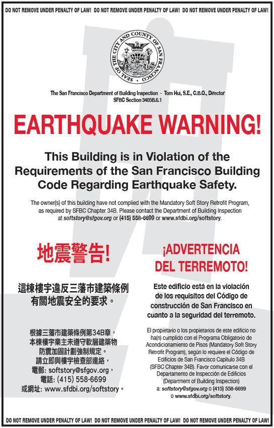
The Resilient City
In 2009, SPUR launched the Resilient City, an initiative to rebuilding and recovery in the months and years after a
address the challenge of seismic safety in San Francisco.17 major quake. SPUR’s recommendations for better seismic
The resulting series of nine policy reports addressed the resilience went on to inform San Francisco’s Community
potential for a major earthquake and what to do about it Action Plan for Seismic Safety and the city’s 30-year
in three sequenced parts: Before the Disaster, Emergen- Earthquake Safety Implementation Plan. They were also
cy Response and After the Disaster. The comprehensive instrumental in prompting former Mayor Ed Lee to create
suite of policy ideas in these reports included defining and host the nation’s first-ever Lifelines Council, which
resilience and seismic performance objectives for every- is dedicated to improving the seismic performance of
thing from homes to hospitals to power lines, addressing critical infrastructure and its interdependencies in an on-
the dilemma of existing buildings and keeping them going way. Work to implement these recommendations is
safe enough to live in after a major event, upgrading currently underway, led by the city’s Office of Resilience
“lifeline” infrastructure such as power and water lines, and Capital Planning.18
preparing for community-based disaster response, and
17 SPUR, The Resilient City, 2008–2013, https://www.spur.org/featured-project/
resilient-city
18 For more information, visit www.onesanfrancisco.org
Hazard exposure and
vulnerability
The presence of natural hazards is only one part of understanding risk. Risk is also a function of which people
and places will be exposed to a hazard, how severe the impact will be on those people and places and how
difficult it will be for them to recover.
Exposure identifies the communities that could experience the risk and the geographical extent of differ-
ent hazards, such as fires, flooding and earthquakes. Vulnerability considers the degree to which structures
and infrastructure are likely to be damaged or destroyed and how much people are likely to be impacted.
Vulnerability also assesses which populations, structures and infrastructure may be least able to cope with a
hazard or to recover quickly. To prioritize efforts to improve resilience, a city or other government agency must
understand all of these variables.
The Bay Area’s exposure and vulnerability can be measured and understood in two ways. First, a survey of
past damages allows us to understand the nature and cost of various types of events like flooding and wildfire,
as well as the geographic extent of areas that might experience recurrent hazards. Figure 4 lists some of the
major presidentially declared disasters that have affected the region in the last 50 years.15
FIGURE 4 California frequently experiences disasters
Major Presidentially Declared that impact multiple counties and cause
Disasters Affecting the Bay Area in losses in the hundreds of millions to billions
the Last 50 Years of dollars.
Sources: Multiple sources including FEMA (https://www.fema.gov/disasters) and ABAG (“Disasters Affecting the San Francisco Bay Area,1950–2009,” http://resilience.abag.ca.gov/wp-content/documents/ThePlan-D-2011.pdf)
LOSS IN U.S. DOLLARS
EVENT (NOT INFLATION- STRUCTURES
NAME OF DISASTER CATEGORY DATE COUNTIES INVOLVED ADJUSTED) LOST DEATHS
Lake, Marin, Monterey,
Russian River Flood Flood Feb. 2019 $155 million 1,900 1
Napa, Sonoma, Yolo
Tubbs, Nunn, Atlas and
Fire Oct. 2017 Napa, Solano, Sonoma $14.5 billion 8,900 44
Wine Country Fires
South Napa Earthquake Earthquake Sep. 2014 Napa, Solano $300 million 2,000 2
Alameda, Contra Costa,
Severe Storms, Flooding, Dec. 2005–
Flood Lake, Marin, Napa, Santa $300 million 1,000
Landslides and Mudslides April 2006
Cruz, Solano, Sonoma, Yolo
Severe Storms, Flooding, Jan.–April
Flood Statewide $1.8 billion 10,300 28
Landslides and Mudslides 1995
Oakland Hills Fire Fire Oct. 1991 Alameda $1.5 billion 3,000 25
Alameda, Monterey, San
Loma Prieta Earthquake Earthquake Oct. 1989 Benito, San Mateo, Santa $6.9 billion 12,000 63
Clara, Santa Cruz
Contra Costa, Santa Cruz,
Northern California Flood Flood Jan. 1982 $280 million 25–32
Sonoma
El Niño Flood 1982–83 40 coastal counties $800 million 7,800 33
Second, scenario planning can forecast the potential damage from simulated future events. For example,
USGS’s HayWired earthquake scenario examined at length the cascading consequences of a scientifically re-
alistic 7.0-magnitude earthquake on the Hayward Fault.19 The potential hazard impacts include strong ground
shaking, landslides, liquefaction, aftershocks and multiple fires following the earthquake, including the loss of
firefighting water due to broken and depressurized pipes. Estimates of property damage and losses from busi-
ness disruption come to $82 billion, with 77,000 households displaced. If other factors (such as utility outages)
are included, more than 152,000 households, or 411,000 people, could be displaced by the shaking-related
damages. Other loss estimates include 800 people killed, 18,000 nonfatal injuries and over 22,000 people
requiring rescue from collapsed buildings and stalled elevators. While the USGS and its partners in the scenar-
io study acknowledged that as much as $50 billion has been invested into seismic safety of infrastructure in
the Bay Area in the 30 years since the Loma Prieta Earthquake, there is still a lot more to be done to reduce
impacts to vulnerable people, buildings and lifeline infrastructure.
19 USGS, The Haywired Earthquake Scenario: We Can Outsmart Disaster, April 2018, https://pubs.
usgs.gov/fs/2018/3016/fs20183016_.pdf16
Equity and vulnerability
Earthquakes and climate hazards affect everyone, but some social groups are more vulnerable than others,
including people with low incomes, immigrants, communities of color, elders and young children. The poor air
quality resulting from higher temperatures and heat waves will disproportionately affect these groups, along
with those who have certain preexisting health conditions. Those with low incomes and those who don’t speak
English are less able to access emergency resources like evacuation information, emergency housing and
transportation. People who are more vulnerable often do not have sufficient insurance or the financial reserves
necessary to recover from a disaster. They are more likely to occupy housing that is made with less resistant
materials or that has not been retrofitted for earthquakes, wildfires or flooding. They’re also at greater risk of
Source: ABAG, Stronger Housing, Safer Communities: Strategies for Seismic and Flood Risks, 2015, http://resilience.abag.ca.gov/projects/stronger_housing_safer_communities_2015/
long-term displacement in the event of a major disaster. Figure 5, adapted from the report Stronger Housing,
Safer Communities by the Association of Bay Area Governments (ABAG),20 describes factors that contribute
to a community’s disaster vulnerability and to its ability to recover.
FIGURE 5
Considerations for Community Vulnerability
Many Bay Area residents are resource-constrained. This
includes households with low or very low incomes, house-
holds of all income levels that spend a high percentage of
Many community their earnings on housing and transportation, and house-
members have holds that depend on transit because they don’t have a
limited access to car. Resource-limited households are less able to prepare
for natural disasters and, if displaced from damaged
resources homes, will likely struggle to find housing that is afford-
able and near to the jobs, schools, medical facilities and
other services they rely on.
Many of the region’s residents are already cost-burdened
Housing affordability
with regard to housing, meaning that they spend more
is an existing than 30% of their income on housing. After a disaster, if
challenge that many housing units are too damaged to live in, a con-
is aggravated strained market could drive up the cost of housing even
further and aggravate the existing lack of affordable
by climate risk
housing. This will likely increase the number of people
and could hinder who leave the Bay Area because they can’t find housing
recovery they can afford.
20 ABAG, Stronger Housing, Safer Communities: Strategies for Seismic and Flood Risks, 2015,
http://resilience.abag.ca.gov/projects/stronger_housing_safer_communities_2015/17
Renters typically can’t control how their buildings are
designed, operated or retrofitted for disaster. Neither
are they likely to have hazard insurance to protect them-
Renters have limited selves and their belongings in case of a disaster. During a
ability to improve disaster, communities with a large number of renters, and
their housing in particular resource-limited renters, will need to provide
these residents with emergency shelter facilities. After a
resilience disaster, resource-limited renters will need help finding
interim affordable housing to avoid being permanently
displaced from communities due to damaged housing.
Many community Access to timely, accurate and meaningful information
members have lim- both before and after a natural disaster can be chal-
ited or inadequate lenging in all communities and can be particularly hard
to find in communities with a large number of non-En-
information about
glish-speaking households.
hazards
Up-to-date and easily accessible information about the
number of elders and young children living in a com-
munity can be challenging to find, particularly during a
Information on elders disaster. It can be difficult to evacuate these community
and very young com- members, especially if they need specialized equipment
munity members is or supervision. Emergency shelter facilities need to be
prepared to house them safely and to maintain communi-
limited cation with concerned family members.18
Figure 6 shows the number and magnitude of earthquake, fire and flooding risks in various areas, overlaid
with the location of Communities of Concern, as identified by the Metropolitan Transportation Commission and
the Association of Bay Area Governments (MTC-ABAG). These are census tracts with concentrations of disad-
vantaged groups such as minority, low-income, senior and disabled populations; people with limited English
proficiency; zero-vehicle and rent-burdened households; and single-parent families.21 While this map shows
that every part of the Bay Area is exposed to one or more hazards, it also identifies those communities that
may be less able to cope with exposure and may need extra support to prepare for, respond to and recover
from a disaster.
21 MTC-ABAG, Plan Bay Area 2040: Final Equity Analysis Report, July 2017, http://2040.planbayar-
ea.org/sites/default/files/2017-07/Equity_Report_PBA%202040%20_7-2017.pdf19
0 10 20
MILES
N
Sonoma
Napa
Solano
Marin Sacramento-
San Joaquin
RiverDelta
Contra Costa
San
Francisco
Alameda
FIGURE 6
Risks and Community Vulnerability in the San Mateo
Bay Area
Areas with multiple hazards have a higher risk of
danger. This map aggregates multiple hazards
and gives more weight to hazards that occur with
greater intensity and frequency. These areas are
then overlaid with Communities of Concern, which Santa Clara
have a higher socioeconomic vulnerability to risk.
View an interactive version of this map
Weighted hazards included: Multi-Hazard Areas
• Earthquake Shaking Intensity (MMI 7/8/9)
= 5+ Hazards (or fewer, but of greater magnitude)
• Fire Zones (Moderate/High/very High)
• Liquefaction Susceptablility (High/Very High) = 3-4 Hazards (or fewer, but of greater magnitude)
• Alquist Priolo Fault Zones = 1-2 Hazards
• Tsunami Evacuation Zones
= MTC-ABAG Communities of Concern
• Sea Level Rise (modeleled for 2040-2060)20 2. How California Manages and Governs Hazard Resilience
21

Today, disaster-related risks in the Bay Area are managed through a number of
government programs and tools, many of them implemented at the state level.

Community land use, hazard
mitigation and resilience planning
California leads the nation with its approach to managing the risks posed by earthquake and cli-
mate-related hazards. State law requires risk assessment and management as part of community-level
planning. All cities and counties must adopt a general plan to guide future development, and all gener-
al plans must include a safety element to protect the community from risks such as earthquakes, fires
and floods.
     One of seven required general plan elements, the safety element directs all cities and counties
to adopt a comprehensive plan that addresses seismic hazards, flooding, wildfire, liquefaction, other
geological hazards, hazard mitigation strategies and climate adaptation. In the last 10 years, the state
legislature has made changes to safety element requirements in response to new and increasing risks.
Cities and counties are now required to address the risk of fire in very-high-wildfire hazard areas (2012
Senate Bill 1241) and to include climate change information and adaptation strategies (2015 Senate Bill
379) in their general plans. The Governor’s Office of Planning and Research (OPR) provides general
plan guidance to cities and counties on developing safety elements. Safety elements are not frequent-
ly updated by local governments, and they are not required to be updated except to comply with
these recent changes to state law.
     Another tool that cities and counties have is the local hazard mitigation plan (LHMP). These are
not required by state law, but the Federal Emergency Management Agency (FEMA) does require them
for governments to be eligible for federal hazard mitigation grants and post-disaster funding. In prac-
tice, many local jurisdictions adopt LHMPs and include that information in their safety element as well.
(State law also encourages this.) The Federal Disaster Mitigation Act of 200022 requires that states
review LHMPs to gather hazard, vulnerability and mitigation information from the local level for use in
state-level planning; to ensure that local jurisdictions are made aware of the hazards and vulnerabilities
within their jurisdiction; and to develop strategies to reduce those vulnerabilities. The hazard mitiga-
tion planning staff at the state Office of Emergency Services (Cal OES) assists local governments in
the development of LHMPs and provides limited technical assistance, training and outreach to local
jurisdictions. Cal OES reviews all LHMPs and coordinates with local jurisdictions to ensure compliance
with FEMA’s Local Mitigation Plan Review Guide before final review and approval by FEMA. Most Bay
Area cities have adopted LHMPs.
     Other local government plans and policies that may include hazard information and resilience
policies or programs include general plans, local coastal plans (required by the California Coastal Act),
specific plans, climate action plans and resilience strategies.

22 For the text of the law, see: https://www.caloes.ca.gov/HazardMitigationSite/Documents/Disas-
ter Mitigation Act of 2000.pdf
22
Building and lifeline codes
and standards
In California, the design and construction of buildings must follow the California Building Code, which
requires that all new buildings are designed to withstand flood and earthquake loads and limit the
impacts of fires. Seismic provisions have been in place for many decades and have evolved consider-
ably over time as research and real earthquakes have tested building performance. For the most part,
current seismic provisions focus on protecting lives and avoiding life-threatening damage. They do
not address the protection of building contents or set standards for maintaining the functionality of
plumbing, electrical and other systems in the aftermath of a damaging earthquake. As a result, even a
newly constructed building can incur costly repairs and be uninhabitable for weeks or months follow-
ing an earthquake it was designed to withstand.
In 2005, California adopted the model building and fire codes of the National Fire Protection
Association, which include special provisions for the construction of new buildings in state or local fire
hazard areas. In Special Flood Hazard Areas designated by FEMA and the California Department of
Water Resources, structures must be raised above the base flood elevation by a specified amount for
the area, plus a margin of safety (called the “freeboard”).
There are many codes, standards, guidelines and manuals that govern the design, construction and perfor-
mance of transportation and lifeline systems and system components.23 Developed in a variety of ways, they
vary considerably from system to system. Most tend to cover minimum levels of safety or performance for
parts of their system (though not for systemwide performance), and most address day-to-day operations and
not extreme, low-probability, high-consequence events like earthquakes, floods and wildfire. The processes by
which lifeline codes, standards and guidelines are developed represent various levels of consensus, most typi-
cally among operators, regulators and engineering experts.
The California Public Utilities Commission regulates privately owned electric, natural gas, telecommunica-
tions, water and transportation companies. Public transportation and utilities, such as BART, Muni, AC Transit
and many of the Bay Area’s water and wastewater providers, are overseen by locally appointed or elected
boards and commissions. Most regulators adopt the latest codes and standards, and some even add more
stringent requirements for both new and existing systems. However, even if codes and standards are adopted,
their effectiveness might be jeopardized by poor enforcement during planning, design and construction of
infrastructure components, or due to a lack of funding for resilience upgrades.
23 Applied Technology Council, Critical Assessment of Lifeline System Performance: Understand-
ing Societal Needs in Disaster Recovery, National Institute of Standards and Technology, April 2016,
http://dx.doi.org/10.6028/NIST.GCR.16-917-3923
Approaches to Risk:
Avoid, Mitigate, Transfer, Retain
There are four basic options for controlling risks: avoidance, reduction or mitigation, sharing or transfer, and re-
tention.24 The challenge in risk decision-making is to find the best solution, not the only solution. The best solution
depends on the circumstances, values and priorities of the decision-makers.
Risk avoidance means deciding not to pursue a project that would introduce new risks, such as building in a
flood hazard zone. Risk avoidance tools include prohibiting development in certain areas, offering voluntary prop-
erty buyouts, making zoning requirements more restrictive and forbidding the occupancy of hazardous or dam-
age-prone buildings. Although avoidance is highly effective, it may be impractical, or it may need to be balanced
with other considerations, such as a community’s need to build new housing. Some risks, such as damage from
earthquakes, are not technically possible to eliminate at this time: We cannot stop earthquakes from occurring and
cannot practically retrofit all structures to survive them undamaged. Once a risk is known, avoidance, if possible and
affordable, may be the best course of action.
Risk reduction or mitigation strategies usually reduce the frequency or severity of the potential losses resulting
from a risk. Risk reduction tools include passing stricter building codes, instituting hazard warning systems, creating
redundant infrastructure, strengthening or retrofitting structures and infrastructure and establishing emergency
facilities for vulnerable populations before and after a disaster.
Risk-sharing or transfer strategies shift the risk-bearing responsibility to another party, and that party then
handles any losses. Insurance is a classic example of an economic risk transfer technique. Another example occurs
during the land development process, when the streets, sidewalks and other infrastructure built as part of the proj-
ect are deeded to local agencies. As part of this transfer, local agencies then assume the costs and associated risks
of maintaining infrastructure and services. Other risk-sharing tools include real estate hazard disclosures, geologic
hazard abatement districts, transfer of development rights and insurance pools.
Risk retention by public agencies occurs when they choose to fund potential losses, either wholly or partially,
with their own resources. The most visible form of risk retention is self-insurance that communities accept know-
ingly. For example, electing not to insure city-owned buildings against potential damage from floods and earth-
quakes means that those risks are self-insured. More commonly, risk is retained unknowingly because governments,
businesses and residents are unaware of the risk. In addition to self-insurance, risk retention tools include not taking
action at all, using catastrophe bonds and establishing a line of credit for lost revenues or asset losses.
24 L. Johnson, L. Dwelley Samant and S. Frew, Planning for the Unexpected: Land Use Devel-
opment and Risk, American Planning Association, 2005, https://planning-org-uploaded-media.
s3.amazonaws.com/publication/download_pdf/PAS-Report-531.pdf24
Insurance
Property insurance is a primary form of risk transfer and an important source of post-disaster financing.
For residents and businesses, California is the nation’s largest insurance market, with over 1,300 insurance
companies collecting $310 billion in premiums annually and holding $5 trillion in assets under management.25
Most local governments in the United States participate in risk pools, which effectively operate like insurance
companies to share the risk across public buildings and infrastructure and to purchase reinsurance as a group.
Nationwide, about 95% of homeowners have basic residential insurance coverage.26 In California, a
standard homeowners insurance policy covers the risk of fire but excludes earthquake- and flood-related risks.
The California Department of Insurance regularly conducts a data call to estimate the residential insurance
coverage for fires and earthquakes across the state. Across the nine-county Bay Area, there are over 2.4 million
residential fire insurance policies for homeowners, condominium unit owners, mobile homes and renters.27
If residents and businesses are unable to obtain fire insurance coverage in the voluntary private insurance
market, the California FAIR Plan Association exists as an insurer of last resort, providing basic fire insurance
coverage for residential and commercial buildings, as well as personal property coverage for residential and
business occupancies. The coverages offered on a FAIR Plan policy are much more limited than standard
residential or commercial insurance policies.
The take-up of residential and commercial earthquake insurance is far lower than fire insurance, both
because fire insurance is typically required by mortgage lenders and because earthquake insurance is very
expensive. For example, only 11% of homeowners with a fire insurance policy in the nine-county Bay Area
also have an earthquake policy.28 About two-thirds of the residential earthquake insurance policies statewide
are provided by the California Earthquake Authority (CEA), a not-for-profit, privately funded and publicly
managed organization. Most of the commercial earthquake insurance in the state covers large commercial
buildings.29
The National Flood Insurance Program (NFIP) is a primary provider of basic residential and commercial
flood insurance policies. Data from the NFIP indicate that there are even fewer properties with flood insurance
than with earthquake insurance in the nine-county Bay Area.30 High-hazard flood zones are smaller than the
areas exposed to strong ground shaking and other earthquake hazards, but flood risk exists outside the official
flood zones mapped by FEMA and is likely to be much more variable with climate change. Note that the NFIP
is not the only provider of flood insurance; many residential and commercial properties with NFIP policies also
buy an excess flood insurance policy to extend their coverage.
25 E. Mills et al., Trial by Fire: Managing Climate Risks Facing Insurers in the Golden State, Cali-
fornia Department of Insurance, September 2018, https://www.law.berkeley.edu/wp-content/up-
loads/2018/09/Trial-by-Fire-September-2018.pdf
26 C. Wilkinson, “How Many Homes Are Insured? How Many Are Uninsured?,” The Triple-I Blog,
Insurance Information Institute, January 26, 2016, http://www.iii.org/insuranceindustryblog/how-
many-homes-are-insured-how-many-are-uninsured
27 California Department of Insurance, “Fire and Earthquake Policy Count per County as of De-
cember 31, 2017,” http://www.insurance.ca.gov/0400-news/0200-studies-reports/0250-homeown-
ers-study/upload/C-Policy-Count-by-County-2_v1.pdf
28 Ibid.
29 California Department of Insurance, California Earthquake Zoning and Probable Maximum
Loss Evaluation Program: An Analysis of Potential Insured Earthquake Losses from Questionnaires
Submitted to the California Department of Insurance by Licensed Property/Casualty Insurers in
California for: 2002–2010, 2012, https://www.insurance.ca.gov/0400-news/0200-studies-reports/
upload/EQ_PML_RPT_2002_2010.pdf
30 FEMA, “National Flood Insurance Program Policy Information by State and Community, as of
June 30, 2019,” https://www.fema.gov/policy-claim-statistics-flood-insurance25
Not only are there differences in the insurance take-up rates for fire, earthquake and flood hazards, but
there are also important differences in the policy coverages.31 For example, under a standard homeowners
fire policy, there are coverages for the dwelling itself and attached structures, other structures (i.e., detached
garage and sheds), personal property and loss of use. The maximum value for dwelling coverage for both a
standard homeowners fire policy and the CEA homeowners earthquake policy is the estimated cost to rebuild
the dwelling and attached structures. The California FAIR Plan homeowners fire policy sets a maximum value
for all coverages at $1.5 million, and the NFIP residential flood policy sets a maximum value of $250,000 for
dwelling-related losses. Neither the CEA earthquake nor NFIP flood policies cover losses to other structures,
and the NFIP also does not cover loss of use.
Of the already-small portion of residents and businesses who are insured for earthquakes and floods,
many are underinsured, with a gap between the actual cost of repairing or replacing damaged property and
the payout received from a claim. Post-disaster surveys consistently find that more than half of homeowners
do not have adequate coverage to replace or rebuild their homes after disaster strikes.32 Underinsurance can
be caused by insurance limits that are too low, gaps in coverage due to policy exclusions and high deductibles.
Underinsurance delays or hinders rebuilding, compounds the trauma of loss and weakens communities’ ability
to rebound from devastating events.
Voluntary programs
In addition to required local plans, voluntary programs offer ways to improve community resilience
at the local scale and often are aimed at reducing insurance costs for property owners. For example,
FEMA’s Community Rating System is a voluntary program that provides reduced flood insurance pre-
miums for property owners in communities that participate in the National Flood Insurance Program
but proactively manage floodplains in ways that go beyond the program’s minimum requirements. Fire
safe councils are community-led organizations that educate homeowners about wildfire preparedness
and sometimes develop community wildfire protection plans. These plans provide a framework for
federal forest management and fuel reduction activities near communities, and they recommend local
actions for improving the fire safety of structures in the WUI.
31 California Department of Insurance, Residential Insurance: Homeowners and Renters, Revised
May 2018, http://www.insurance.ca.gov/01-consumers/105-type/95-guides/03-res/res-ins-guide.
cfm#coveragea; California Earthquake Authority, “CEA Homeowners Policy Coverages & Deduct-
ibles,” 2019, https://www.earthquakeauthority.com/California-Earthquake-Insurance-Policies/
Homeowners/Coverages-and-Deductibles; California FAIR Plan Property Insurance, “Dwelling
Policy,” 2019, https://www.cfpnet.com/index.php/consumers/dwelling-policy/
32 United Policyholders, “Underinsurance Help: Were You Lulled into a False Sense of Security, or
Did You Intentionally Underinsure Your Biggest Asset?,” https://www.uphelp.org/guide/underinsur-
ance-help-were-you-lulled-false-sense-security-or-did-you-intentionally-underinsure26 Summary It is worth noting that most existing tools are not designed to be cross-jurisdictional or applied at the region- al scale. Even the plans that are multi-jurisdictional recommend actions that are mostly local. This limits the effectiveness of resilience planning. One community’s actions to increase resilience — or its failure to act — can affect its neighbors and the region as a whole. A county-by-county or city-by-city approach, combined with voluntary efforts, may adequately recognize differences in goals, values and the hazards to be addressed, but it’s not enough to secure regional resilience in cases where communities are adjoining and interdepen- dent. What one community in the WUI chooses to do affects the fire safety of all adjacent communities. What one community chooses to do about earthquake-vulnerable buildings and infrastructure affects surrounding neighborhoods and the economy. What one community chooses to do on its shoreline to manage sea level rise affects flooding for its neighbors. When development occurs upstream in a watershed, it can affect flooding downstream by increasing the speed, volume and water quality of runoff. Failing to plan regionally means that resilience investments might not have the expected payoff or safety benefits, or they might not improve con- ditions for the community at large. Of course, proactive cities and counties can go above and beyond expec- tations, innovating new standards that can be broadly applied and adopted. This kind of leadership benefits those communities and increases regional resilience, though it is no substitute for a shared baseline of safety.
27
28

3.
Policy Recom-
mendations
and Discussion
29

As the Bay Area grows, our exposure and potential vulnerability to hazards will increase unless we do further
planning for risk and prioritize a variety of strategies to reduce risk. Meanwhile, there is better information than
ever before about what future hazards and impacts might look like. SPUR sees a need and an opportunity at
the regional scale to address the vulnerabilities of the region’s interconnected, interdependent infrastructure
systems and communities — and at the local scale within the region, because of its multi-hazard exposure.
In some cases, to create a level playing field and provide better information, SPUR suggests strategies at the
state level. This report makes 12 recommendations in four categories, covering how we can improve data and
information gathering, codes and standards, community planning, and funding for multi-hazard resilience in
the Bay Area.

FIGURE 7
Recommendations Summary

CATEGORY                SCALE               RECOMMENDATIONS

                                            1. Develop dynamic, web-based maps that reflect current and potential future property risk across
Data and information    State
                                            multiple hazards.

                                            2. Adopt a statewide functional recovery building standard so that more buildings will be usable and
                        State
                                            easily repaired after a disaster.

                        State, regional     3. Require cities and counties to inventory and screen buildings for vulnerability to wildfires, flooding
                        and local           and earthquakes in areas of known risk. Make certain retrofits mandatory within 20 years.

                                            4. Create a regional lifelines council to identify interdependencies between utility systems, assess
Building and lifeline
                        Regional            their vulnerability to hazards, set regionwide mitigation priorities and identify ways to fund critical
codes and standards
                                            upgrades within the next 10 years.

                                            5. Consolidate certain single-purpose special districts (such as fire or flood prevention) into multi-
                        Local
                                            hazard resilience districts and expand their geography as needed.

                                            6. Develop local disaster recovery frameworks in every city and county to help ensure that local
                        Local
                                            jurisdictions are ready to manage recovery following a major disaster.

                                            7. Change zoning codes to prevent further development in high-hazard areas that are significantly
                                            vulnerable to fire, liquefaction and sea level rise, with priority consideration in those areas
                        Local
                                            where multiple hazards overlap. Ensure no net loss of planned housing by accommodating new
Community planning
                                            development in low-hazard existing urbanized areas.

                        Local               8. Acquire undeveloped hazard-prone lands for public ownership and use.

                                            9. Develop a regional or state buyout program for properties repeatedly damaged by wildfire,
                        State or regional
                                            flooding or other climate impacts.

                                            10. Ensure that insurance for fire, earthquake and flood hazards remains available and affordable for
                        State               residents and businesses. Ensure that state insurance regulations encourage and appropriately price
Funding                                     resilient land use, new construction and retrofit practices.

                                            11. Establish a regionwide geologic hazard abatement district, or a series of countywide districts, to
                        Regional
                                            pool resources to fund regional resilience projects.

                                            12. Establish a regional resilience trust fund for future climate adaptation and hazard management
                        Regional
                                            needs.
You can also read