Draft Management Plan - Doonan Creek Environmental Reserve 2017 2027 - AWS
←
→
Page content transcription
If your browser does not render page correctly, please read the page content below

Doonan Creek Environmental Reserve
   Draft Management Plan

                       2017 - 2027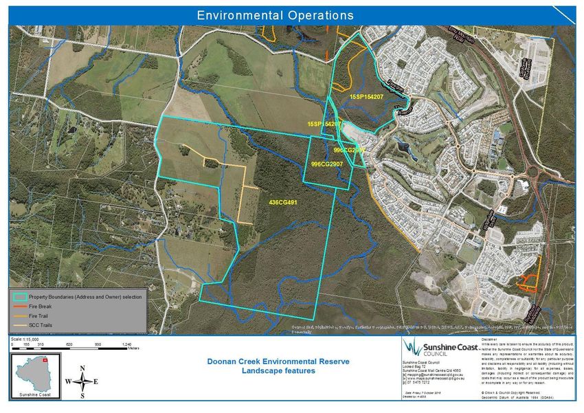
© Sunshine Coast Regional Council 2009-current.
Sunshine Coast Council™ is a registered trademark
of Sunshine Coast Regional Council.
www.sunshinecoast.qld.gov.au
mail@sunshinecoast.qld.gov.au
T 07 5475 7272 F 07 5475 7277
Locked Bag 72 Sunshine Coast Mail Centre Qld 4560
Acknowledgements
Council wishes to thank all contributors and stakeholders
involved in the development of this document.
Disclaimer
Information contained in this document is based on
available information at the time of writing. All figures
and diagrams are indicative only and should be referred
to as such. While the Sunshine Coast Regional Council
has exercised reasonable care in preparing this
document it does not warrant or represent that it is
accurate or complete. Council or its officers accept no
responsibility for any loss occasioned to any person
acting or refraining from acting in reliance upon any
material contained in this document.
Contents
Executive Summary.................................................................................. 4
1 Introduction............................................................................................ 5
    1.1 Purpose of the management plan.................................................... 5
    1.2 Management intent ......................................................................... 5
2 Description of the reserve..................................................................... 6
    2.1 Location and description ................................................................. 6
    2.2 History and landuse ........................................................................ 7
3 Establishment Works .......................................................................... 10
4. Reserve Values ................................................................................... 13
    4.1 Ecological Values .......................................................................... 13
    4.2 Cultural and Social Values ............................................................ 20
    4.3 Economic Values .......................................................................... 21
    4.4 Condition of the Values ................................................................. 22
5. Bioregional landscape Context ......................................................... 26
    5.1 IBRA ............................................................................................. 26
    5.2 Catchment ..................................................................................... 26
    5.3 Local Planning Context ................................................................. 26
    5.3 CAR Contribution .......................................................................... 26
6. Management Issues............................................................................ 27
    6.1 Regional Background .................................................................... 27
    6.2 Preliminary Threat Analysis ........................................................... 27
    6.3 Restricted Matters and Locally Significant species ........................ 28
    6.4 Plant Pathogens ............................................................................ 29
    6.5 Fire................................................................................................ 29
    6.6 Erosion .......................................................................................... 30
    6.7 Acidity/Salinity ............................................................................... 30
    6.8 Historical Land Use ....................................................................... 31
    6.9 Climate Change ............................................................................ 32
    6.10 Visitor Use ................................................................................... 32
7. Implementation Plan........................................................................... 33
    7.1 Purpose of the Protected Area ...................................................... 33
    7.2 Management Objectives ................................................................ 33
    7.3 Restoration Goals.......................................................................... 33
    7.5 Management Actions..................................................................... 34
    7.6 Finance and Resourcing ............................................................... 41
    7.7 Comminaction Plan ....................................................................... 41
    7.8 Monitoring and Plan Review Schedule .......................................... 41
Appendices ............................................................................................. 45
                                                                                                             3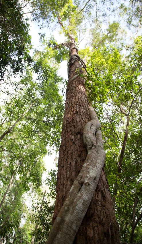
Executive Summary                                 food trees, such as Swamp Mahogany and
                                                  Forest Red Gum.
Doonan Creek Environmental Reserve
                                                  The site is a birdwatchers paradise with over
protects a key link in the Maroochy Noosa
                                                  125 different species identified including
wallum corridor—one of the most important         many migratory birds that are dependent on
coastal habitat areas on the Sunshine Coast.      the food and shelter resources found here.
The majority of the reserve (252ha) was           Some of the migratory birds which can be
acquired through Council’s environment levy       seen include the storm bird (Koel) and the
land acquisition program in 2013, creating a      channel billed Cuckoo, arriving in summer
total protected area of 334hectares of diverse    each year from as far away as New Guinea
habitat ranging from iconic coastal heath,        and South East Asia. During the winter
scribbly gum forest to melaleuca wetlands.        months other species such as the scarlet
                                                  honeyeater fly from the south during their
The reserve is located within the traditional
                                                  east coast migration. Many local bird species
boundaries identified for the Kabi Kabi people
                                                  that depend on this site also migrate from the
and the name Doonan comes from an
                                                  hinterland to the coast in winter. The brightly
Aboriginal word meaning “leaf of a tree”. The
                                                  coloured noisy pitta that is found at Mary
whole reserve and surrounding landscape has
                                                  Cairncross Scenic Reserve through the
evidence of past activities of the Kabi Kabi
                                                  summer months can be found foraging for
traditional owners making this area culturally
                                                  land snails at Doonan Environmental reserve
and historically significant.
                                                  in winter.
Doonan Creek Environmental Reserve is
                                                  The reserve contains areas of open space
situated to the west of Peregian Springs within
                                                  and ecotone which add to the complexity and
the Doonan Creek drainage basin which flows
                                                  diversity of the site as well as providing
into Coolum Creek.
                                                  opportunities for community access and
There are thirteen confirmed regional             enjoyment. In particular this site is
ecosystems (RE) within the entire reserve         distinctively located in close proximity to both
area, including critically endangered (EPBC       high density and peri-urban populations.
Act 1999) subtropical lowland rainforest (RE
                                                  Therefore the reserve is categorised as a
12.3.1) found within the new levy acquisition
                                                  “bushland” environmental reserve in which
component.
                                                  the management intent is to protect and
208 terrestrial and 84 aquatic/wetland plant      enhance the sites terrestrial, riparian and
species have been identified in the reserve,      aquatic habitats while also allowing for
including the ‘endangered’ Emu Mountain She-      opportunities in sustainable nature based
oak (Allocasuarina emuina) and Sunshine           activities where public access is guided by
Coast Myrtle (Lenwebbia sp blackall range).       the development of a landscape design.
Fauna surveys identified 10 frog species, 13      Planning will incorporate technologies in open
reptile species, 24 different mammals, and 7      data, explore the rich cultural knowledge of
freshwater fish species, including the            the area, provide sustainable access for
‘vulnerable’ Wallum Froglet which was found in    enjoyment and learning and build on
the open area drains, flooded pasture and in      partnersips with the community.
the Melaleuca forest.                             This plan guides future management of the
Koalas which are listed as ‘vulnerable’ were      reserve over the next 10 years to ensure the
also recorded in the reserve during fauna         significant ecological values are protected
surveys and the site contains areas of Koala      and maintained.

4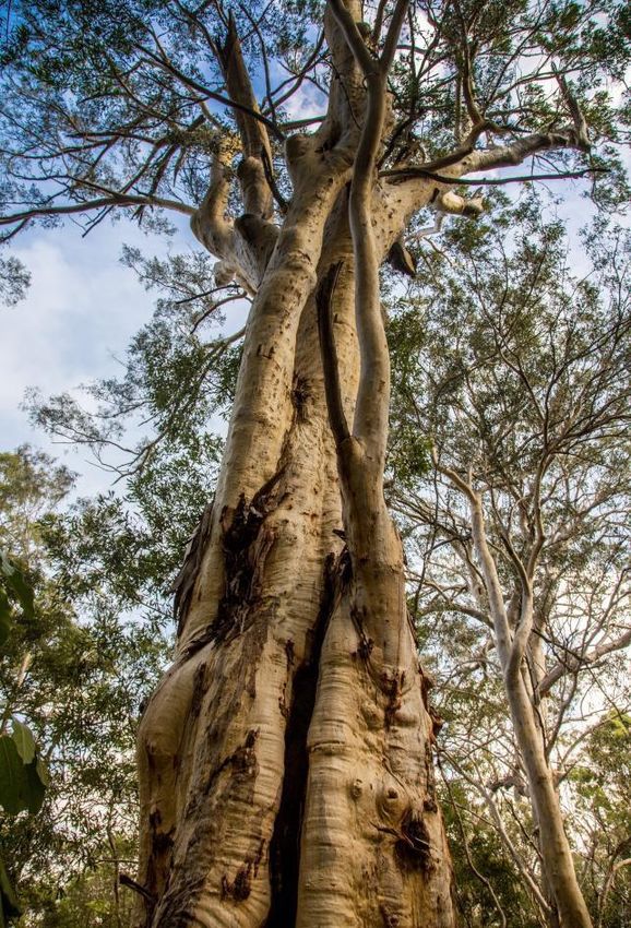
1 Introduction                                      social and economic values and express the
                                                    associated management actions required to
This management plan supports Sunshine              maintain or enhance these values.
Coast Councils corporate vision “to be
Australia’s most sustainable region – healthy,
                                                    1.2 Management intent
smart, and creative”.                               The reserve category for this site is
                                                    “Bushland” environmetal reserve. Under this
In order to achieve this, council’s Sunshine        category the management intent is to ensure
Coast Environment and Liveability strategy          the significant ecological values are protected
focuses on the preservation and enhancement         and maintained, whilst allowing for sustainable
of the natural environment and the liveability of   public access that is managed through the
the region—ensuring native plants, animals,         development of a reserve landscape design
and habitats are healthy, resilient and valued      and associated signage and purpose built
by the community. A key policy position to          infrastructure.
delivering on this outcome is that priority
habitat areas are protected, enhanced,
connected and responsive to changing
environmental conditions. This is supported
through the environment levy land
acquisition program.
Under the land acquisition program, 252
hectares of the Doonan Creek Environmental
Reserve was purchased—protecting a key
link in the Maroochy Noosa wallum corridor.
In 2015, state-owned properties to the north-
east were added to the Doonan Creek
Environmental Reserve management area—
bringing the total area to 334 hectares.
The reserve is currently managed by Council’s
Natural Areas Planning team and the Natural
Area Operations team (Appendix 2a).

1.1 Purpose of the management
    plan
This Management Plan provides an adaptive
management framework which has been
developed under nationally recognised
guidelines and principles of protected area
management (Appendix 1).
The Management Plan is subject to a 10-year
review schedule underpinned by the framework
of actions, relevant monitoring and evaluation
strategies,    and    performance   indicators
described in this plan.
The purpose of this Management Plan is to
describe the reserve’s ecological, cultural,

                                                                                                 5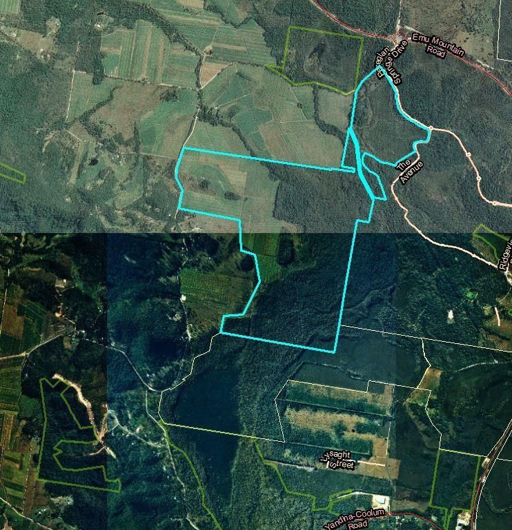
2 Description of the reserve Lot 436 on CG491 (Lot 436) -
Council freehold
2.1 Location and description Lot 996 on CG2907 (Lot 996) -
The Doonan Creek Environmental Reserve Council trustee
is situated to the west of Peregian Springs
Lot 15 on SP154207 (Lot 15) -
as shown in figure 1. The reserve can be
Council trustee
accessed for maintenance via Doonan
Bridge Road, Verrierdale on the western The terrain within the reserve is dominated
boundary and via Thomson Street in by relatively uniform floodplain associated
Peregian Springs on the eastern boundary. with Doonan Creek with low rises (10m
ASL) present in the western and north-
The reserve is comprised of the following
eastern sections of the reserve (Appendix
three allotments (shown in figure 1):
2c).
.
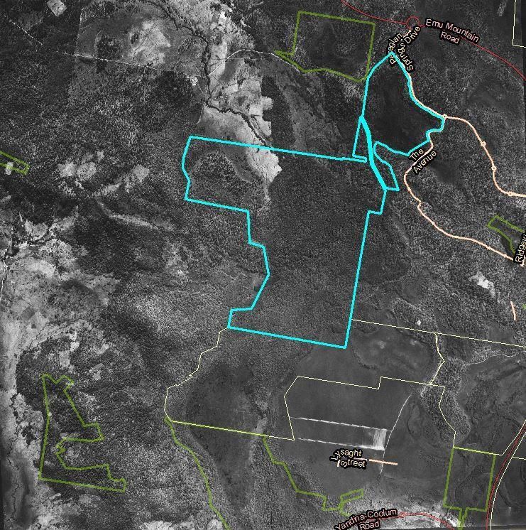
Figure 1. Doonan Creek Environmental Reserve landscape features
of the reserve into Coolum Creek. The main
2.1.1 Catchment and Landscape Context
channel of Doonan Creek enters the central
The reserve is located within the lower middle north of Lot 436 and drains to the south-west
section of the 54 km2 Doonan Creek drainage after traversing a large area of Melaleuca
basin, which flows from the southern boundary swamp forest in the southern component of the
of the Noosa Shire and discharges to the south
6
reserve. A number of artificial drainage 2.2 History and landuse
channels also occur within the reserve. The Doonan area is the traditional land of the
In combination with other Council and of the Kabi Kabi people. Prior to and
Queensland Government managed following European settlement important
conservation reserves, the site forms a resources were present in the reserve for
component of a north-south regional corridor indigenous people’s culture and economy,
identified in the Queensland Government particularly in the areas of lowland forests,
Biodiversity Planning and Assessment swamps and riverine sites along Doonan
Mapping (BPA) for SEQ (Maroochy River to Creek (Mathew 1910; Petrie 1904). For
Elliot Heads Terrestrial Corridor) (EPA 2006) example, the roots of the Bungwall or Swamp
(See map in Appendix 2d). The southern Water Fern (Blechnum indicum) that occurs
boundary of Lot 436 is linked to the Noosa extensively across the reserve were a staple
National Park. in the local indigenous diet (Mathew, 1910).
The property is also mapped as a Core To this day many remnants of the Kabi Kabi
Habitat Area in Council’s Sunshine Coast peoples land management and culture can
Biodiversity Strategy 2010 – 2020 (SCC 2014) be seen throughout the reserve and the
and forms part of the National Estate’s surrounding landscape including pathway
Maroochy-Noosa wallum corridor (Barden signs along Doonan Bridge road (Kerry
1998) (Appendix 2e) Jones, Kabi Kabi, pers comm.)
European settlement in the Doonan and
2.1.2 Land zones Coolum region commenced in the 1890’s
The reserve is identified under Queensland with bullock teams used to recover the
Government RE mapping (v8) as containing l og g e d timber and land settlement in the
the following four land zones (Appendix 2f). vicinity of the reserve was based on
Quaternary sandplain deposits in the leases where conversion to freehold was
extreme south-eastern corner of reserve contingent on land clearing
(Land Zone 2); “improvement” (Gregory 1991). Early
cadastral mapping show that the current
Quaternary alluvial river and creek flats property boundaries for the reserve were
throughout reserve (Land Zone 3); established prior to 1920 (Figure 2a).
Remnant tertiary surfaces +/- Cainozoic Other early agricultural activities included
and Mesozoic sediments on a low rise beef production, dairying, and sugar cane
that occurs in Lot 996 and Lot 15 (Land and banana crops. A gricultural
Zone 9- 10); and development of floodplain sites in the region
Mesozoic to Proterozoic igneous rocks was facilitated by the construction of a
forming low hills in the western portion network of drains to channelize the floodplain
of Lot 436 (Land Zone 12). and dry out the wetland (Windolf and Windolf
Tertiary-early Quaternary loamy and 2004).
sandy plains and plateaus In the It is likely that the freehold portion (Lot 436)
northern portion of Lot 15 (Land Zone 5) was selected as a farming block by William
Land Zone 3 (Quaternary alluvium) is the Hamilton in the Ninderry land reserve
most widespread geological type within the release of 1888. William Hamilton
vegetated areas of the reserve constructed one of the first sugar mills on his
land selection in 1893 and while early
attempts to grow sugar cane on the reserve
and in the local area failed, the mill was
7
used for many years to crush arrowroot
(Gregory 1991). I n t h e 1 9 2 0 s c a n e
farming was successfully established in the
region.

Figure 2a: Map source – Moreton 40 Chain map sheet 17 north, 1920

Figure 2b: Aerial images showing land use history 1958 and 1994

Historical aerial photography indicates that        1950’s (Figure 2b). Further clearing
much of the western section of Lot 436              occurred on the western margins of the
was cleared for agriculture or grazing by the       forested section of Lot 436 following the

8
expansion      of    cane     farming.  The          manager and has not been subject to
construction      of   drains     and    the         previous land clearing for agriculture. A
channelisation of portions of the western            cleared fire trail is located within this area
branch of Doonan Creek within the reserve            and the area is adjacent to urban streets
are likely to have been associated with the          and house lots on the western margin of
expansion of sugar cane to the site in the           the Peregian Springs estate (Figure 1.)
post 1950’s period. The aerial photography           The reserve has historically been situated in
indicates that few changes to the vegetation         a rural landscape comprising agricultural
cover have occurred in the period following          land and forested habitats on large rural lots.
the cessation of cane farming with the               In the early 2000’s an area of dense urban
exception of developing areas of Melaleuca           development was established to the east of
and Acacia regrowth on the eastern margin            the reserve at Peregian Springs and
of the cleared non-remnant component of              development in this area is ongoing
Lot 436 (Figure 2b).                                 (Appendix 2b).
Following the loss of cane allocations in the late   The proximity of the urban area has resulted
1990’s and closure of the Moreton Mill in 2004,      in some edge effects on the margin of the
the cleared areas of the reserve have been           reserve, including artificial lighting, noise
used to graze cattle.                                and weed infestations from dispersal of
State government land to the east and south of       seeds and dumping, as well as minor
the reserve was formerly held by the                 impacts from human access, domestic dogs
Queensland Department of Primary Industries          and possibly cats (P. Barden personal
as unallocated crown land and timber reserve.        observation).
A DPI research field station was established in      The fire history of the reserve is poorly
1952 on 700 hectares to the south-east of the        known. A wildfire was recorded in 2009 in
reserve (Windolf        and Windolf 2004).           t h e national park areas to the south-east
Investigations at this site in the 1950’s to         and in 2017 the Peregian-Coolum Wildfire
1980’s focused on the potential for establishing     impacted approximately 40% of the reserve.
pine plantations, pasture and cropping on
extensive coastal wallum areas held by the           Small Council planned burns w e r e
state government (Bryan 1973). Slash pine            undertaken in 2009 & 2013 within a small
(Pinus elliotii) infestations in the local area      (1.3 ha) asset protection zone on the
originated and spread from trial plantings in the    northern and eastern boundaries of the water
vicinity of the research station (DEH 1994).         and camping reserve. (Scheduled to be burnt
These schemes failed and following closure of        every 3-5 years). A burn also took place in
the station in 1983, state government land           the north west of Lot 15 on SP154207 in
(timber reserve and experimental farm) to the        2012, which was a dual purpose hazard
                                                     reduction and ecological burn covering 5ha.
south and east of the reserve were converted
to a range of contemporary land uses including       The vegetation present in the central and
urban      development      (Coolum     Ridges),     northern sections of Lot 436 (Melaleuca
conservation (Noosa National Park, West              and Eucalypt dominated canopy with
Coolum Section), community leases and an             regenerating gallery vine forest species in
industrial precinct (Windolf and Windolf 2004;       the mid-canopy) indicate that these areas
QPWS 1999).                                          have, until recently remained unburnt over a
                                                     long period of time.
Lot 996 is a state camping and water
reserve where Council is the trustee land

                                                                                                       9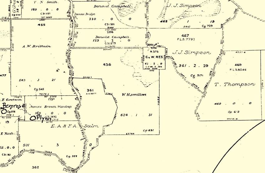
3 Establishment Works Future Directions Report (scheduled)
All properties purchased under the Fauna and flora assessments 2014-
Environment Levy Land Acquisition Program 2015)
receive an annual allocation of funding for In addition to these, the Environmental
establishment works as a percentage of the Reserves Net work manag em ent plan
purchase price from the Environment Levy ( 2017) provides an overarching
budget. This initial injection of funds covers management framework to guide priorities
the establishment costs for a period of 3-6 and review schedules for management and
years and prepares the reserve for future operational activities.
operational maintenance.
Doonan Creek Environmental Reserve will
Establishment works completed for Doonan also be assessed for potential cultural
Creek Environmental Reserve to date are values and further assessment undertaken
described in Table 1 below. It is anticipated if required.
that due to the extent of open space recovery
The on-going planning and maintenance
required at Doonan Creek Environmental
requirements of Doonan Creek
Reserve, establishment works will extend
Environmental Reserve are guided by
beyond 2018. After this the reserve will be
Council’s Service Level Reserve Score,
managed by the Natural Areas operations
(rank 1-3 for each biodiversity and
team, guided by this Management Plan and
recreation score).
supporting technical documents which are also
summarised in this plan. The scoring matrix includes a biodiversity
and a recreational score for each reserve
The following planning reports have been
based on a range of criteria including size,
completed or scheduled, with key elements
connectivity, significant species,
incorporated into this management plan.
biodiversity and recreational use.
Doonan Ck Environmental Reserve
The biodiversity score for Doonan Creek
Regeneration Works Plan (Brush
Environmental Reserve is regional reserve
Turkey Enteprises 2014)
– B1. There is currently no recreational
Bushland Operation Assessment (BTE score since recreation planning has not
2014 and Hansen 2007) been finalised. Table 2 and 3 lists
Fire Management Plan (2012) service level requirements under this
category.
Doonan Ck Environmental Reserve
public involvement plan (Group GSA
2015)
Draft Landscape Design Plan (SCC 2017)
Table 1: Status of establishment works at Doonan Creek Environmental Reserve.
Establishment Description Status
Activity
Condition Commission the preparation of a resilience based BOA completed 2007
Assessment condition assessment (Bushland Operational (Lot 15 and Lot 996) and
Assessment - BOA) to guide management. 2014 (Lot 436 and Lot
996)
Restoration Commission the preparation of a Bush Regeneration RWP completed 2014
Works Plan Works Pan (RWP) to gude management. (Lot 15 and Lot 996)
10Weed According to the works plan all high priority areas are Annual works plan
Management targeted for weed removal implemented in line with
Maintain cattle agistment in open grassed areas to service level for this reserve
prevent weed growth, pending ecological restoration,
revegetation and open space planning.
Trail Maintenance of access and fire trails Management trails
construction constructed and mapped on
and Council open space layer
maintenance Trail construction as per Landscape Design Plan completed 2015
Landscape planning
underway
Access Gate Install access gates and fencing at entrance. Access gate and fence
and fencing installed 2013
Revegetation Revegetate open areas which have not been Offset 11ha koala habitat
designated open space. planted in 2014.
Include recommendations to address shortage of Revegetation underway with
fruiting rainforest trees which are necessary to maintain annual community tree
populations of resident and migratory bird species. planting commenced in
2016.
4 305 plants including
fruiting rainforest food trees
Signage Install reserve signage at access points Signage installed 2013
Tenure Progress perpetual protection Current
Protection
Values Commission a flora and a fauna assessment at Lot Aquatic and terrestrial flora
assessment 436 and Lot 996; Undertake Cultural heritage protected surveys, 2014; mammals
matters search and follow up as required with cultural; and reptiles survey, 2014;
heritage assessment. frog and fish survey 2015;
Avian survey 2014; cultural
heritage protected matters
search, 2013.
Hazards Address following potential hazards and waste; Bulk of iron and rubbish
removed removed 2015;
Remnant of farm shed;
Regulated waste removed
General farm waste and iron 2016.
Broken fences and barbed wire Shed demolished and
removed 2017.
Regulated waste (tyres and batteries) Barbed wire fencing
removed 2017
10
8Table 2: Planning Service Levels
Category MP BOA Flora Fauna FMP Work Plan
survey survey
*B1
Frequency 10 yr 5 yr 10 yr 10 yr 10 yr 5 yr
Current Draft Complete Complete Complete Scheduled Complete
status 2014 2014 2015 review 2016 2014
*B# = Biodiversity Class
Note: The above table provides an overview of the required planning documentation required.
SMI = Statement of Management Intent, BOA = Bushland Operational Assessment, FMP = Fire
Management Plan
Table 3: Maintenance Service Levels
Category B1
Inspections Monthly
Weed Management Monthly
Revegetation Annual
Prescribed burning – if required As per FMP
Fire trail management drainage/surface Annual
maintenance
Fire trail slashing 4 x per year
Fuel reduced zones management 4 x per year
Tree management Annual
Urgent & hazardous matter arising 24-48 hours
124. Reserve Values 4.1.1 Vegetation Communities and
Ecosystems
4.1 Ecological Values Vegetation communities within the reserve
Doonan Creek Environmental Reserve have been assessed using existing RE
protects coastal regional ecosystems which mapping (Queensland Government, v8).
have been extensively cleared across the Mapping indicates that approximately 64.7%
Sunshine Coast. (216 hectares) of the reserve is covered in
remnant vegetation comprising thirteen RE
Natural values of the reserve have been
types (Appendix 2f).
documented during a number of surveys since
Council commenced management, with data The mapping shows that pursuant to the
compiled in the following resources1: Queensland VM Act (Appendix 2f).
Terrestrial flora assessment (Thomas 5.3% (17 hectares) of the reserve is
2013) mapped as an ‘endangered’ RE
Birds of the Doonan Creek ‘11.6% (38 hectares) of the reserve. is
Environmental Reserve – Avian fauna mapped as having a subdominant
assessment (Barden 2015) Endangered’ RE
Preliminary Assessment of mammal 4.3% (14 hectares) of the reserve with
and reptile fauna of Doonan Ck an ‘of concern’ RE
Environmental Reserve (O2 Ecology 40.3% (134 hectares) of the reserve
2015) where REs have an ‘of concern’
An assessment of the frog and fish Biodiversity Status (Appendix 2f and
habitat values at Doonan Ck 2g).
Environmental Reserve (Meyer 2015) 3.7% (12.14 ha) of the reserve area
Bushland Operation Assessment (BTE supports three areas of High Value
2014 and Hansen 2007) Regrowth (HVR) containing an
‘endangered’ RE. (Appendix 2j)
Aquatic flora assessment (Thomas 2014)
A number of surveys and management plans Areas of ‘least concern’ and ‘of
provide additional and historical information on concern’ HVR are also present (4.65ha
species and habitats within the local area and 0.3ha respectively
(McFarland 1989; SKM 1989; DEH 1994; Ground surveys of vegetation distribution
Barden 1998; Bergstrom 1998; within Lot 436 and Lot 996 confirmed the
McDonald2002; EPA 2007 Meyer 2010; Rose presence of seven vegetation communities
et al, .2015). and equivalent RE types within this portion
of the reserve (Thomas 2013) (Table 4 and
All fauna and flora data records have been
Appendix 2h).
entered into the state Wildnet database.
Regional ecosystems observed at the reserve
include:
RE 12.3.1, which is listed as
‘endangered’ under the Queensland
Vegetation Management Act 1999 (VM
Act) and ‘critically endangered’ under
the Environment Protection and
Biodiversity Conservation Act 1999,
1 The scope of flora and fauna assessments is restricted
to Lot 436 and Lot 996 at this reserve
10
8 RE 12.3.11, which is listed as ‘of sugar cane and urban development
concern’ under the VM Act. (Queensland Government 2014)).
RE 12.3.5 is listed as ‘least concern’ The remaining RE types observed within
(VMA Class) and ‘of concern’ Lot436 and Lot 996 are ‘least concern’ (VMA
(Biodiversity Status) under the VM Act. class) and ‘no concern’ (Biodiversity Status)
(RE 12.3.5 has been extensively under the VM Act (Table 4).
cleared in south-east Queensland for
Table 4: Regional Ecosystems observed at Doonan Creek Environmental Reserve (Lot 436 and Lot
996)
RE VMA class Short Description (Sattler and Williams Distribution in the reserve
/BD Status 1999; Thomas 2013)
12.2.12 LC / NC Closed heath on seasonally waterlogged Approximately 3 hectares in the south-east corner
sand plains. of the reserve.
12.3.1 EN / EN Gallery rainforest (notophyll vine forest) on Confined to floodplains associated with Doonan
alluvial plains Creek in the central north of the reserve.
12.3.5 LC / OC Melaleuca quinquenervia open forest on Broad areas of the alluvial plain associated with
coastal alluvium Doonan Creek. Intergrades with RE 12.3.1
(subdominant) in the central and north-eastern
sections of Lot 436.
12.3.6 LC / NC Melaleuca quinquenervia, Eucalyptus Limited area on the south-western reserve
tereticornis, Lophostemon suaveolens boundary (Lot 436).
woodland on coastal alluvial plains
12.3.11 OC / OC Eucalyptus siderophloia, E. tereticornis, Narrow distribution on the northern boundary of
Corymbia intermedia open forest on alluvial Lot 436 and 996.
plains
12.9-10.4 LC / NC Eucalyptus racemosa woodland on Occurs on the slope in the north-eastern section
sedimentary rocks of Lot 996.
12.9-10.17 LC / NC Eucalyptus microcorys, E. racemosa, E. Mapped as RE12.12.12 in Qld Govt. RE mapping,
tindaliae, Corymbia intermedia, however Thomas (2013) identified this area as a
Lophostemon confertus tall open forest on mosaic of RE12.9-10.17 and 12.9-10.4. Isolated
sedimentary rocks (Thomas 2013) remnants located in the western pasture.
LC = Least concern; OC = Of concern; EN = Endangered
Table 5. Sunshine Coast LGA status of RE’s found
at Doonan Ck Environmental Reserve (Sunshine
More recent and comprehensive vegetation Coast Council biodiversity report card, 2015
assessment data has been developed for the
Sunshine Coast local government area RE Poorly conserved SCLGA
(SCLGA) based on a fine scale (LIDAR) (10% adequacy at Vulnerable (lost >70%
vegetation mapping report. This assessment, SCC/SEQ) of pre-clear extent)
shows that four of the seven RE types found 12.3.1 SCC/SEQ -
within the reserve are poorly conserved
throughout SEQ and/ or the Sunshine Coast 12.3.6 SCC 73
(Table 5 and Appendix 3). RE 12.3.11 has 12.3.11 SCC 95
had the greatest loss relative to its pre-
clearing extent with 95% cleared in the 12.9-10.4 SCC 79
SCLGA
14Management Actions howittiana and Philotheca queenslandica
(Thomas 2013).
Undertake a detailed flora assessment at
Lot 15 on SP154207 to verify vegetation 208 native terrestrial and 84 native aquatic/
communities and equivalent RE types wetland plant species have been identified so
occurring there
far at the Doonan Creek Environmental
Reserve in 2013 – 2014, including the
4.1.2 Flora ‘endangered’ Emu Mountain She-oak and
Two hundred and eight (208) native flora Sunshine Coast Myrtle.
species in eighty-one (81) families were
A number of additional listed ‘threatened’
recorded during the terrestrial flora
and ‘near threatened’ plant species have
assessmentat Lot 436 and Lot 996 (Thomas
been reported from areas to the north and
2013). Twenty-three (23) exotic species were
east of Lot 996 (McDonald 2002), including
also identified in this portion of the reserve
Symplocos harroldii (‘near threatened’) and
(Thomas 2013).
Acronychia littoralis (‘endangered’). The
An assessment of the aquatic flora at Lot status of these species in the local area
436 and Lot 996 identified eighty-four (84) remains unknown and they were not
aquatic/ wetland native flora species and observed during recent surveys of the
ten (10) aquatic/ wetland weed species reserve (Thomas 2013).
within Lot 436 and Lot 996 (Thomas 2014).
Appendix 4 lists all flora species found in
this portion of the reserve to date. Management Actions
The area supports two observed Undertake a detailed flora assessment at
‘threatened’ plant species that are listed Lot 15 on SP154207 to verify vegetation
communities and equivalent RE types
under the EPBC Act 1999 and the occurring there
Queensland Nature Conservation Act 1992
(NC Act) (Table 6). Other significant species
recorded are Acacia flavescens, Myrsine
Table 6: Listed ‘threatened’ plant species found at Doonan Creek Environmental Reserve
Common Name Scientific Name Status
Emu Mountain She-oak* Allocasuarina emuina Endangered (EPBC Act)
Endangered (NC Act)
Sunshine Coast Myrtle Lenwebbia sp. ‘Blackall Range’ Endangered (NC Act)
(P.R.Sharpe 5387)
* A. emuina is now treated as a synonym of A. thalassoscopica (Rose et al. 2015
4.1.3 Fauna 13 reptile species
Field surveys conducted over spring and 125 bird species
summer in 2014 – 2015 at Lot 436 and Lot
996 identified 179 native vertebrate fauna 16 ground dwelling, scansorial and
species, comprising the following numbers of arboreal mammal species
species in each of the major terrestrial fauna 8 bat species
groups.
7 freshwater fish species
10 amphibian species
10
8Environmental Reserve are shown in Table 7
Appendix 5 lists all current fauna records for
below.
the reserve. Details of the status of listed
‘threatened’ species recorded at Doonan Creek All fauna records have been added to the
Queensland government Wildnet Database.
Table 7: Listed ‘threatened’ fauna species known to occur at Doonan Creek Environmental
Reserve and adjacent habitats
Common Scientific Name NC Act EPBC Record Locality Source
Name Act
Doonan Creek Environmental Reserve – Confirmed Records
Wallum Crinia tinnula Vu Flooded pasture, drains and Meyer (2015)
Froglet regrowth, western reserve
RE 12.3.5 south-eastern
reserve
Koala Phascolarctos Vu Vu RE12.3.5/12.3.1 northern O2 Ecology (2014)
cinereus central reserve
Existing Records Adjacent Areas
Wallum Litoria Vu Vu East of the reserve (Peregian McDonald
Sedgefrog olongburensis Springs area) (2002)
Wallum Litoria freycineti Vu East of the reserve (Peregian McDonald
Rocketfrog Springs area) (2002)
Glossy Calyptorhynchus Vu Open forest to the east of McDonald
Black- lathami Lot 996 (Peregian Springs) (2002)
cockatoo
Ground Pezoporus Vu West Peregian section, Noosa DEH (1994)
Parrot wallicus wallicus National Park (1994)
Powerful Ninox strenua Vu Open forest to the east of Lot McDonald
Owl 996 (Peregian Springs) (2002)
Koala Phascolarctos Vu Vu RE12.9-10.4 north-eastern McDonald
cinereus reserve margin adjacent to (2002)
Lot 996
Grey- Pteropus Vu West Peregian section, Noosa DEH (1994)
headed poliocephalus National Park (1994)
Flying-fox
Swamp Tenuibranchiurus En Regional records in wallum
Crayfish glypticus habitat (RE 12.2.12/12.3.5)
Tusked Adelotus brevis Vu Regional records Doonan area
Frog (Queensland
Museum)
16The Australian government draft recovery plan grazed pasture and regrowth Melaleuca
for Grey-headed Flying-fox (Pteropus habitat in the western section of Lot 436
poliocephalus) (2017), notes that the primary (Meyer 2015). The Wallum Froglet was also
threat to the survival of this species is loss and calling in flooded Melaleuca woodland (RE
degradation of foraging and roosting habitat. 12.3.5) in the south-eastern section of the
Key recovery actions under this plan are to reserve in January 2014 (P. Barden personal
“identify, manage and secure key foraging and obs.). The ‘vulnerable’ Koala. (Phascolarctos
roosting habitat”. This action is also included in cinereus) occurs in tall open forest (RE
Councils Regional Flying Fox Management 12.9-10.4) in the north-east section of the
Plan to encourage populations of Flying-fox to reserve (Lot 996) (McDonald 2002), and has
move out of the urban roost sites where their been recorded in core areas of the reserve
habitat footprint is diminished through various where important Koala food trees such as
roost management actions. Swamp Mahogany (Eucalyptus robusta)
and Forest Red Gum (Eucalyptus
Sunshine Coast Council has developed a
tereticornis) occur in RE 12.3.5 on the
flying fox habitat map showing the vegetated
Doonan Creek floodplain (O2 Ecology 2014).
areas of Doonan Creek Environmental
Barden (2014) provides a review of the
Reserve are suitable flying-fox habitat that is
significance of the Doonan Creek
low conflict (>300m from occupied buildings),
Environmental Reserve for migratory birds,
as shown in the appendix 2l map. It is
including regional, altitudinal, east coast
therefore noted that for the protection of the
and extra-limital migrants (see Table 8 and
vulnerable Grey-headed Fying-fox, any
9). A number of winter migrant birds,
potential foraging and roosting sites within the
including species involved in east coast
reserve will be protected and—where
migration from southern to northern
appropriate—enhanced.
Australia and birds that move from higher
Two listed ‘threatened’ fauna species are altitudes to the coastal lowlands during
known to occur in this reserve, including the winter months, were more abundant within
‘vulnerable’ Koala and Wallum Froglet. the reserve during the cool season surveys
(Barden.2014).
The ‘vulnerable’ Wallum Froglet (Crinia
tinnula) was recorded in drains, flooded
Table 8: Listed Migratory and Marine species (EPBC Act) at Doonan Creek Environmental Reserve
Common Name Scientific Name EPBC Act 1999 Habitat/RE Type
White-throated Hirundapus caudacutus Migratory/Marine Aerial/RE 12.3.5
Needletail
Rainbow Bee-eater Merops ornatus Marine Acacia regrowth, 12.2.12, 12.9-
10.14, 12.3.1, 12.3.5
Cattle Egret Ardea ibis Marine (JAMBA) Pasture
White-bellied Sea- Haliaeetus leucogaster Marine Pasture, 12.3.1
eagle
10
8Table 9: Migration systems for birds recorded within the Doonan Creek Environmental Reserve
Season Warm season Cool season east Cool season Regional Nomadic
migrants coast migrants altitudinal migrants Species
Migration Northern Australia/ East coast migration Move between higher Move between
System Extra-limital (e.g. system, moving from altitude habitats (e.g. habitats and areas in
NewGuinea, south-eastern Australia Blackall and response to
Conondale Ranges)
W allacea, Eurasia). to SEQ during the cool availability of
and coastal lowlands.
Absent or at low season Disperse to SEQ resources (e.g.
abundance during the lowland habitats during flowering events)
cool season period in cool season
SEQ
Examples Channel-billed Cuckoo Yellow-faced Noisy Pitta Rose Robin Rainbow Lorikeet
of bird Cicadabird Spangled Honeyeater Scarlet Golden Whistler Brown Scaly-breasted
species Drongo Rainbow Bee- Honeyeater Eastern Gerygone Green Lorikeet Brown
recorded Catbird Eastern
eater Eastern Koel Spinebill Silvereye Honeyeater White-
Spinebill Satin
within the White-throated Spotted Pardalote cheeked Honeyeater
Bowerbird
reserve Needletail Rufous Whistler Leaden
Flycatcher Rose Robin
Summer migrant birds that were present olongburensis) from the Peregian Springs
within the reserve include species that area (McDonald 2002). The ‘vulnerable’
migrate to northern Australia or New (EPBC Act) Grey-headed Flying- foxes
Guinea/Wallacea during the SEQ winter (Pteropus poliocephalus) is likely to feed on
(Barden 2014). flowering and fruiting trees in forested
sections of the reserve and has been
recorded in the West Coolum Section of
Noosa National Park (DEH 1994)
Closed heathland (RE 12.2.7) in the West
Coolum Section of the Noosa National Park
formerly supported a population of the
‘vulnerable’ Ground Parrot (Pezoporus
wallicus) (DEH 1994), however this species
has not been observed in this area during
recent surveys.
Rainbow Bee-eaters at Doonan Ck Enviroronmetal Reserve Fire management is an important factor in
managing Ground Parrots, with the species
The reserve also contains suitable habitat
thought to be excluded from areas that
for additional listed ‘threatened’ and ‘near
remain unburnt for long periods of time
threatened fauna species and a number of
(McFarland 1989).
these have been recorded in adjacent
habitats. These include records of the There is suitable habitat within the reserve for
‘vulnerable’ Powerful Owl (Ninox strenua), other listed ‘threatened’ species that are known
Glossy Black- cockatoo (Calyptorhynchus to occur in the region, including the
lathami), Wallum Rocketfrog (Litoria ‘vulnerableTusked Frog (Adelotus brevis)
freycineti) and Wallum Sedgefrog (Litoria
18and the ‘endangered’ swamp Crayfish habitats favoured by species such as the
(Tenuibranchiurus glypticus) Wallum Froglet and Ground Parrot.
(Management Actions
Undertake measures to The reserve supports an area of regionally
protect and enhance Wallum
uncommon riparian and floodplain forest
Froglet populations
habitats that have been preferentially
Consider the requirements of Koala clearedin SEQ. These habitat features include
when undertaking revegetation/
offset programs ie. Include locally
areas of open forests on low rises,
occurring Koala food trees (e.g. uncommon floodplain swamp forest with vine
Eucalyptus microcorys, E. forest elements, riparian gallery vine forests
tereticornis and E.propinqua) in and instream habitat along drainage lines,
tree planting
and areas of Melaleuca and heathland
Undertake fire management planning in typical of coastal wallum.
heath areas to potentially create
conditions suitable for Ground Parrots, in Management Actions
consultation with QPWS
Identify and protect remaining habitat trees
Undertake ground parrot surveys to and large hollow logs from fire damage
check for recruitment following 2017
wildfire Preserve ecotone habitat by maintaining a
dynamic edge through ecological
Undertake freshwater invertebrate processes.
surveys targeting endangered swamp
crayfish (Tenuibranchiurus glypticus)
Protect and enhance flying fox roosting
habitat.
4.1.4 Habitat
The reserve is identified as Core Habitat under
the Sunshine Coast Biodiversity Strategy 2010
- 2020 and a range of regionally significant and
uncommon species found within the reserve
are dependent on the habitat characteristics
protected by the reserve.
The reserve represents an important
component of a regionally significant habitat
corridor that provides a link between habitats
along the Noosa River to the north and
Maroochy River to the south (Barden 2014).
Areas of the reserve, including open forest
mapped as RE 12.9-10.4, support old growth
canopy trees with large numbers of hollows
and fissures that represent important roost
andnest habitat for wildlife. This includes
suitable Koala food trees (e.g. Eucalyptus
robusta and Eucalyptus tereticornis),
rainforest and ecotonal habitats required for
Mature Scribbly Gum (Eucalyptus racemosa)
rainforest birds, and heath and wallum
with numerous hollows (Image P Barden)
10
84.2 Cultural and Social Values 4.2.2 Ecological Restoration
The condition of remnant habitat with the
4.2.1 Indigenous
reserve is generally rated as ‘very good’
Doonan Creek Environmental Reserve is to ‘good’ under Council’s Bushland
located within the native title application area Operation Assessments (BOAs).
boundary of the Kabi Kabi People2. Establishment works have included
At the time of purchase there were no mapping and control of weeds targeting
Aboriginal cultural heritage sites recorded in areas with high resilience and forest edge
the State Aboriginal Cultural Heritage management.
Database or Register for Lot on plan Balance areas of the reserve (non-remnant)
15SP154207, 436CG491, 996CG2907 and are dominated by open pasture and Acacia
1P242443. However, the absence of recorded regrowth. A component of this area is currently
Aboriginal cultural heritage may simply reflect the subject of a revegetation project being
a lack of cultural heritage surveys in this area. undertaken as a biodiversity offset and further
In areas of the Doonan Creek Environmental offset revegetation is planned for additional
Reserve which are undeveloped and areas. The development of an artificial wetland
undisturbed, there is potential for unrecorded is under investigation.
Aboriginal cultural heritage to be present.
All Aboriginal cultural heritage is protected
under the Queensland Aboriginal Cultural
Heritage Act 2003, and penalties can apply
forany harm caused. The legislation applies
a cultural heritage duty of care whereby any
person carrying out an activity must take all
reasonable and practical measures to ensure
the activity does not harm Aboriginal cultural
heritage. To assist in meeting this duty of care,
there are Aboriginal Cultural Heritage Act 2003
Duty of Care Guidelines that should be
followed. It is a requirement under these
guidelines for the relevant aboriginal party to be
consulted prior to any works that will cause
ground disturbance in a previously undisturbed
area.
Management Actions
Consult Kabi kabi First nation prior to
any works that will cauise ground
Community event planting rainforest fruiting trees for birdlife
disturbance in a previously
undisturbed area.
4.2.3 Eco-recreation
There is no existing recreational infrastructure
in the Doonan Creek Environmental Reserve.
There are no existing trails or access roads
other than a gravel roadway accessing the
2QC13.03 – QUD280/2013, Kabi kabi First Nation,
western pasture areas and fire trail on the
Queensland South native Title Services Limited, Level
10, 307 Queens St, Brisbane, Q 4000.
20eastern side via Thomson Street (Appendix Management Actions
2h).
Investigate the potential for access
The reserve is located immediately to the west and other infrastructure, including
of high density urban development at Peregian boardwalks and bird hides
Springs and Coolum Ridges, with an estimated Investigate potential for constructed
population exceeding 4000 (2011 census wetlands and associated ecotourism/
data). The proximity of the reserve to this urban environmental education
infrastructure in non-remnant habitat
area indicates that recreational use could be in the western section of the site
considered, with a caveat that the ecological
Provide opportunities for public
significance of the reserve should direct uses
involvement in restoration of non-
to be designed with consideration to the remnant areas of the site where
sensitivity and significance of the habitats and appropriate
species protected in the reserve (Appendix Promote partnerships with
2h). organisations to facilitate ongoing
research and data collection within the
There is a high risk to habitats and wildlife reserve
within the reserve from increased access by
recreational users, for example through direct
disturbance by humans, increased presence 4.2.3 Reserve category
of domestic pets (particularly dogs), spread of The reserve is identified as category
weeds and pathogens and unplanned ignition ‘Bushland Reserve’, which is one of the five
of fires. North-eastern components of the categories used for the coordinated
reserve are likely to be particularly vulnerable management and promotion of the reserve
due to the close proximity of densely settled network. The ‘Bushland Reserve’ category
urban areas (Peregian Springs). Recreational reflects the extent of open space which is
use opportunities could be investigated for more resilient to external impacts and may
components of the western non-vegetated support various unsupervised nature based
areas of the reserve. An area of the western activities based on the outcomes of the
non-remnant habitat would be suitable for the landscape design. Reserve categories are
construction of an artificial wetland, which described in more detail in the Environmental
could act as a local hub facilitating bird Reserves Master Management Plan 2017 –
watching and environmental education. 2027. Appendix 6 provides evaluation of
The Sunshine Coast Council Open Space potential reserve categories for this site
Strategy 2011 includes a community hub to
the east of the reserve at Peregian
4.3 Economic Values
Springs, and there are two Future Open Conservation of natural values at the Doonan
Space Recreational Parks and one Future Creek Environmental Reserve may contribute
District Sports Groundfacility nominated by to the local and broader economy. Sunshine
the strategy within 2km of the reserve Coast natural areas represent a major draw-
(Appendix 2l). Two Local Recreation Park card for tourism, including opportunities for
upgrades are identified within this zone to nature-based tourism. Habitats preserving
the east of the reserve. biodiversity can also attract wildlife enthusiasts
and bird watchers from within and beyond the
There are currently seven existing local area
region.
recreation parks and numerous amenity
reserves in the Peregian Springs area. Four Tourism and hospitality are key industries on
educational facilities are located to the east of the Sunshine Coast, contributing $1,078.7
the reserve. million to the local economy and employing
15% of the labour force (2013/2014). In
10
8addition, protection of floodplain vegetation urban areas that may impact wildlife and
may indirectly contribute to commercial and habitat condition in the reserve include
recreational fisheries by improving water domestic animals (cats and dogs), drainage,
quality in the lower Maroochy catchment sedimentation, water quality, weeds, plant
pathogens, water pollution (nutrients and
other chemicals), waste dumping, light
pollution and noise pollution.
Community land uses for land to the south and
south-east of the reserve currently present
amenity issues (noise) in the reserve
Management Actions
Review BOA every 5 years (See Figure 3
below)
Doonan Ck Environmental reserve community field day 2017. Review Regeneration Works Plan
every 5 years
Management Actions
Subsequent BOA and Regeneration
Investigate potential for this reserve Works Plan to cover whole of
to be used for environmental reserve
education and low impact eco-
tourism (e.g. birdwatching
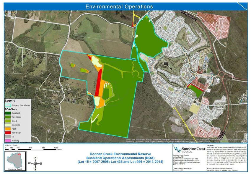
4.4 Condition of the Values Brush turkeys are Natures Bush regenerators-
Bushland Operation Assessments (BOAs)
were completed at Lot 15 and 996 in December
2007 and at Lot 996 and 436 in February 2014
(Figure 3 and Appendix 2m). The BOA
provides a vegetation condition assessment
tool used by Council to guide bush restoration
activities. The condition of the majority of
bushland assessed in 2014 is ‘very good’
(56%) to ‘good’ (8.5%).
Other areas rated by the 2014 BOA are
moderate (2.4%), poor (4.5%) and very poor
(2.2%). Cleared areas that have been retained
as pasture in the western section of the reserve
are excluded from the BOA assessment
Factors potentially influencing the Natures Bush Regenerator (Brush turkey
ecological condition of bushland include the captured by a camera trap on Doonan Creek
presence of cattle in the western portion of Environmental Reserve Image P Barden)
Lot 436, the presence of historical artificial
drainage networks within the reserve and
the potential for edge effects where the
reserve is located in close proximity to
urban areas on the north eastern reserve
boundary. Potential impacts from adjacent
22Figure 3. Bushland Operational Assessment May 2016 (Lot 436 and Lot 996) and December 2007 (Lot 15)
5. Bioregional landscape                                  5.3 Local Planning Context
  Context                                                 The area falls within the Sunshine Coast Council
The bioregional landscape descriptions which              Planning Area. Under the Sunshine Coast
have been included here may be used to                    Planning Scheme 2014 the conservation values
support any future recognition of this reserve            of this reserve have been identified and
as part of a national reserve system3                     protected.

5.1 IBRA                                                  5.3 CAR Contribution
Interim Biogeographic Regionalisation for                 Comprehensive: There are thirteen Queensland
Australia (IBRA) is endorsed by all levels of             Government mapped regional ecosystems at
government as a key tool for identifying land for         Doonan Creek Environmental Reserve that are
conservation. Australia's landscapes have                 included in the SEQ bioregion and SEQ04
been classified into 89 large geographically              Sunshine Coast – Gold Coast Lowlands IBRA
distinct bioregions based on common climate,              sub-region.
geology, landform, native vegetation and                  Adequate: The reserve comprises approximately
species information. Under the latest IBRA (7),           230 hectares of remnant and regrowth
Doonan Creek Environmental Reserve is                     vegetation, with the majority of the vegetation
located in the South-east Queensland                      assessed as being in ‘good’ to ‘very good’
bioregion (no 74) which has a total area of               condition. This indicates that the remnant
7,804,921 hectares. 13.1% of the SEQ IBRA                 habitats within the reserve have a high level of
region is protected in reserves and 13.98% of             resilience and will require lower levels of
the Sunshine Coast / Gold Coast Lowlands                  management intervention to maintain habitat
subregion (SEQ04) that includes the site is               quality.
protected in reserves (Commonwealth of                    The reserve provides important regional links
Australia 2012).                                          between other bushland reserves and regionally
                                                          significant habitat corridors. The reserve
5.2 Catchment
                                                          contributes to ecological viability for flora and
The reserve is located within the Maroochy                fauna populations, species and ecological
River Catchment on the lower middle section of            communities.
the 54 km2 Doonan Creek drainage basin,
                                                          Representative: The regional ecosystem types
which flows from the southern boundary of the
                                                          present within the Doonan Creek Environmental
Noosa Shire and discharges to the south of the
                                                          Reserve provide a representation of the pre-
reserve into Coolum Creek (Barden 2014). The
                                                          clearing landscape that previously covered the
main channel of Doonan Creek enters the
                                                          coastal lowlands of the Sunshine Coast and the
central north of Lot 436 and drains to the south-
                                                          broader South- east Queensland region. The
west after traversing a large area of Melaleuca
                                                          reserve preserves an important mosaic of
swamp forest in the southern component of the
                                                          habitats, including ‘endangered’ riparian vine
reserve. A number of artificial drainage
                                                          forests, floodplain forests dominated by
channels also occur within the reserve
                                                          Melaleuca, forest red gum, swamp mahogany
(Appendix 2b).
                                                          and Lophostemon (with uncommon vine forest
                                                          mid- canopy elements), open eucalypt forests
                                                          and heathlands. A number of these habitats are
                                                          poorly conserved in the SEQ component of the
                                                          National Reserve System

3 Australian Government, 2009, Australia’s Strategy for
the national reserve system, 2009 – 2030.
  34
6. Management Issues at Doonan Creek Environmental Reserve, will
play an important role in protecting ecological
6.1 Regional Background function and associated biodiversity for SEQ.
The SEQ region is the most densely populated 6.2 Preliminary Threat Analysis
part of Queensland, experiencing rapid growth
Throughout the establishment phase of
over the previous two decades (Ambrey and
works undertaken on this reserve, a
Fleming, 2011). The SEQ bioregion has been
range of risks have been identified which
identified as an area which is at a critical
may affect Council’s capacity to protect and
threshold, where increased development
restore biodiversity values of this reserve if
throughout the urban footprint is likely to lead
these are not addressed.
to increasing loss and degradation of remaining
ecosystems and their fauna (Peterson et al. Table 10 highlights the corresponding
2007). opportunities proposed to address each of the
threats identified for the reserve.
Therefore the restoration and recovery of
significant habitat corridors, catchments, and
remnant vegetation, such as that which occurs
Table 10: Summary of reserve management risks and opportunities
Risks Opportunities
Myrtle rust infestation Partnerships with Queensland Herbarium and Myrtle Rust researchers (eg. Garry
on Lenwebbia sp. Thomas)
Blackall Range
Trail network Proactive planning through landscape design process
impacting
sensitive
ecological areas
Lack of fruiting Planting rainforest fruit trees
plants for migratory
and seasonal birds
Fire management Ground Parrot and fire history research (eg. Partnership with Angus Collins
required for listed from Southern Cross University)
‘vulnerable’ ground
Acquisition of adjoining properties to enable joint fire management with QPWS
parrot habitat
Pinus sp. In south-east Partnerships with QPWS
Wallum Froglet habitat Plant areas of surface water with native sedges to provide frog embryos and
degraded by exotic larvae with more cover from predatory fish (Meyer 2015)
fauna including cattle
Plant breeding ponds in sandy, low-nutrient soil areas (Meyer 2015)
and Mosquitofish
Exclude cattle from important habitat areas (Meyer 2015)
35You can also read