HARTENBOS ESTUARY MANAGEMENT PLAN - MAY 2016 - 2016-2021: First Generation EMP
←
→
Page content transcription
If your browser does not render page correctly, please read the page content below
HARTENBOS ESTUARY MANAGEMENT PLAN

    2016-2021: First Generation EMP

              MAY 2016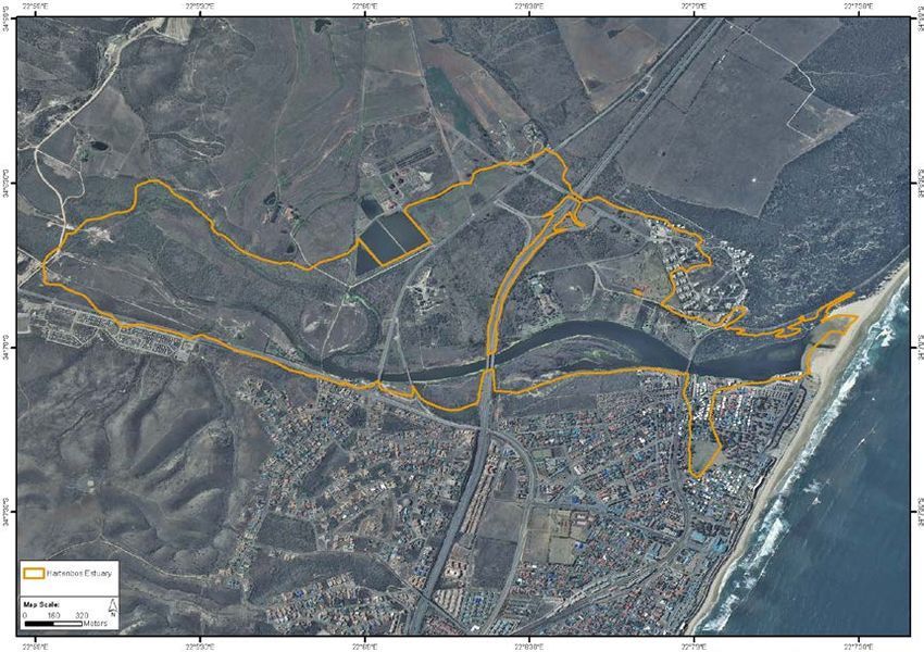
HARTENBOS ESTUARY MANAGEMENT PLAN

      2016-2021: First Generation EMP

                        May 2016

                    Report Prepared by:
        Anchor Environmental Consultants (Pty) Ltd.
8 Steenberg House, Silverwood Close, Tokai 7945, South Africa
             www.anchorenvironmental.co.za

          Vera Massie, Kenneth Hutchings and Barry Clark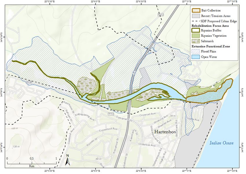
TABLE OF CONTENTS
1       INTRODUCTION ............................................................................................................................................ 1

    1.1         BACKGROUND ........................................................................................................................................... 1
    1.2         PURPOSE AND SCOPE OF THE HARTENBOS ESTUARY MANAGEMENT PLAN ............................................................. 1

2       SITUATION ASSESSMENT ................................................................................................................................ 3

       2.1.1 INTRODUCTION...................................................................................................................................... 3
       2.1.2 GEOGRAPHIC AND SOCIO-ECONOMIC CONTEXT ............................................................................................ 3
       2.1.3 ECOLOGICAL CHARACTERISTICS AND FUNCTIONING ....................................................................................... 3
       2.1.4 ECOSYSTEM SERVICES ............................................................................................................................. 5
       2.1.5 LEGISLATION AND MANAGEMENT ISSUES .................................................................................................... 5
    2.2     UITVOERENDE OPSOMMING ........................................................................................................................ 8
       2.2.1 INLEIDING............................................................................................................................................. 8
       2.2.2 GEOGRAFIESE EN SOSIO-EKONOMIESE KONTEKS ........................................................................................... 8
       2.2.3 EKOLOGIESE EIENSKAPPE EN FUNKSIONERING .............................................................................................. 8
       2.2.4 EKOSISTEEM DIENSTE ............................................................................................................................ 10
       2.2.5 WETGEWING EN BESTUUR KWESSIES ........................................................................................................ 10

3       VISION..................................................................................................................................................... 13

4       ESTUARY MANAGEMENT OBJECTIVES .............................................................................................................. 13

    4.1         IMPROVE ESTUARY HEALTH......................................................................................................................... 13
    4.2         MAXIMISE ECONOMIC BENEFITS .................................................................................................................. 13
    4.3         RESTORE AESTHETIC VALUE ........................................................................................................................ 13
    4.4         INCREASE AWARENESS............................................................................................................................... 14
    4.5         HARMONIOUS AND EFFECTIVE GOVERNANCE ................................................................................................. 14

5       STRATEGIES TO MEET MANAGEMENT OBJECTIVES ............................................................................................... 15

6       KEY RESULT AREAS AND MANAGEMENT ACTION PLANS ...................................................................................... 17

    6.1         KEY RESULT AREA 1: IMPROVE ESTUARY HEALTH ............................................................................................ 17
    6.2         KEY RESULT AREA 2: IMPROVE WATER QUALITY ............................................................................................. 20
    6.3         KEY RESULT AREA 3: EFFECTIVE MOUTH MANAGEMENT .................................................................................. 22
    6.4         KEY RESULT AREA 4: IMPROVE RECREATIONAL VALUE...................................................................................... 23
    6.5         KEY RESULT AREA 5: IMPROVE AESTHETIC VALUE ........................................................................................... 26
    6.6         KEY RESULT AREA 6: INCREASE AWARENESS AND APPRECIATION FOR THE HARTENBOS ESTUARY .............................. 26
    6.7         KEY RESULT AREA 7: RESEARCH AND MONITORING ......................................................................................... 29
    6.8         HARMONIOUS AND EFFECTIVE GOVERNANCE ................................................................................................. 29
    6.9         SUMMARY OF MANAGEMENT ACTIONS AND TIMING ........................................................................................ 32

7       APPENDICES .............................................................................................................................................. 35

    7.1     APPENDIX 1: PROPOSED HARTENBOS ESTUARY ZONATION PLAN ....................................................................... 35
       7.1.1 INTRODUCTION.................................................................................................................................... 35
       7.1.2 GEOGRAPHICAL EXTENT OF THE ESTUARY .................................................................................................. 36
       7.1.3 COASTAL PROTECTION ZONE, COASTAL MANAGEMENT LINES AND FLOOD LINES .............................................. 38
       7.1.4 PROPOSED MANAGEMENT ZONES FOR THE HARTENBOS ESTUARY .................................................................. 39
    7.2     APPENDIX 2: PROPOSED ESTUARY MOUTH MANAGEMENT PROTOCOL FOR THE HARTENBOS ESTUARY, MOSSEL BAY
    MUNICIPALITY ...................................................................................................................................................... 42
       7.2.1 PROBLEM STATEMENT .......................................................................................................................... 42

                                                                                    i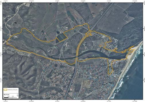
7.2.2 OVERALL OBJECTIVE OF THE LOCAL MOUTH MANAGEMENT PROGRAMME ........................................................ 43
       7.2.3 DESCRIPTION OF THE ESTUARY ................................................................................................................ 44
       7.2.4 MOTIVATION FOR ARTIFICIAL BREACHING.................................................................................................. 45
       7.2.5 BREACHING PROCEDURE........................................................................................................................ 55
       7.2.6 KEY MONITORING INFORMATION ............................................................................................................ 57
       7.2.7 ADAPTIVE MANAGEMENT THROUGH POST BREACHING REPORTING AND CONSULTATION SESSIONS ........................ 59
       7.2.8 REFERENCES ....................................................................................................................................... 60
    7.3     APPENDIX 3: ECOLOGICAL SPECIFICATIONS AND THRESHOLDS OF POTENTIAL CONCERN (TPC) FOR MONITORING
    PARAMETERS LISTED IN APPENDIX 4 .......................................................................................................................... 61
    7.4     APPENDIX 4: RECOMMENDED MONITORING PROTOCOL FOR THE HARTENBOS ESTUARY ........................................ 63
    7.5     APPENDIX 5: NATIONAL RESPONSE PROTOCOL FOR FISH KILLS ........................................................................... 70
    7.6     APPENDIX 6: LISTED ACTIVITIES FOR WHICH AN EIA IS REQUIRED FOR ESTUARIES IN THE WESTERN CAPE ACCORDING TO
    THE NATIONAL ENVIRONMENTAL MANAGEMENT ACT (NEMA) ..................................................................................... 73

8      REFERENCES .............................................................................................................................................. 78

                                                                                ii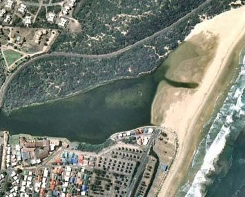
LIST OF ABBREVIATIONS
AEC        Anchor Environmental Consultants (Pty) Ltd.
C.A.P.E.   Cape Action Plan for People and the Environment
CPZ        Coastal Protection Zone
CSIR       Council for Industrial and Scientific Research
DAFF       Department of Agriculture Forestry and Fisheries
DEA        Department of Environmental Affairs
DEA:O&C    Department of Environmental Affairs: Oceans and Coasts
DWS        Department of Water and Sanitation
DEADP      Department of Environmental Affairs & Development Planning
DPWs       Department of Public Works
ECR        Ecological Reserve Category
EDM        Eden District Municipality
EIA        Environmental Impact Assessment
EFZ        Estuarine Functional Zone
EMP        Estuary Management Plan
EMF        Estuary Management Forum
IDP        Integrated Development Plan
KRA        Key Result Area
MAPs       Management Action Plans
MAR        Mean annual runoff
MSL        Mean sea level
MEC        Member of Provincial Executive Council
Mm3        Million cubic metres
MBM        Mossel Bay Municipality
NEMA       National Environmental Management Act (Act 107 of 1998)
ICMA       National Environmental Management: Integrated Coastal Management Act (Act
           No 24 of 2008)
NEMP       National Estuary Management Protocol
NWA        National Water Act, 1998 (Act 36 of 1998)
PES        Present Ecological Status
REC        Recommended Ecological Category
WWTW       Waste Water Treatment Works

                                     iii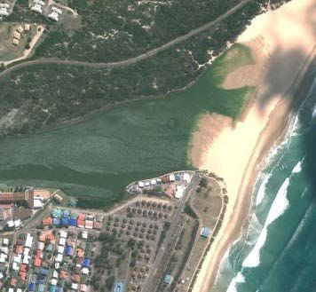
GLOSSARY
Term                              Description
Abiotic                           Non-living chemical and physical parts of the environment that
                                  affect living organisms and the functioning of ecosystems
Biotic                            Associated with or derived from living organisms
Estuarine resident fish species   Estuarine fish species, which breed in estuaries
Estuarine-dependent               Euryhaline marine species which usually breed at sea with the
                                  juveniles showing varying degrees of dependence on southern
                                  African estuaries
Euryhaline                        The ability to adapt to a wide range of salinities
Eutrophication                    Eutrophication is a process whereby water bodies, such as lakes,
                                  estuaries, or slow-moving streams receive excess nutrients that
                                  stimulate excessive plant growth (algae and nuisance plants &
                                  weeds). This enhanced plant growth, often an algal bloom,
                                  reduces dissolved oxygen in the water when dead plant material
                                  decomposes and can cause other organisms to die
Mean annual runoff                The mean of the the total quantity of water that is discharged
                                  ("runs off") from a drainage basin per year within a specified
                                  time period
Mean sea level                    An average level for the surface of one or more of Earth's oceans
                                  from which heights such as elevations may be measured

                                                iv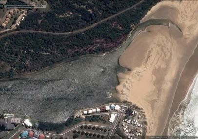
Draft Hartenbos Estuary Management Plan Introduction
1 INTRODUCTION
1.1 Background
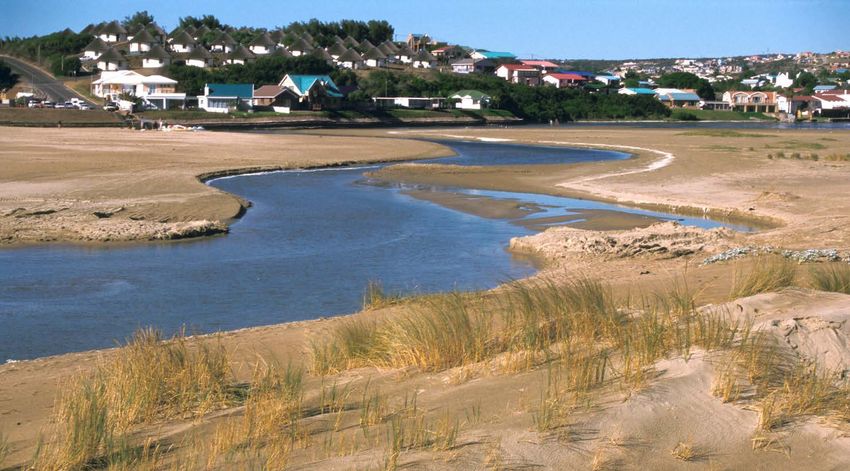
The Hartenbos Estuary is one of South Africa’s approximately 289 functional estuaries and is one of
21 estuaries within the warm temperate biogeographic region to be classified as a temporarily
open/closed (Turpie et al., 2012, Van Niekerk and Turpie, 2012. The Hartenbos is a small estuary
with a relatively large floodplain and covers in total approximately 268 ha. The Hartenbos Estuary is
ranks 74th of all South African estuaries in terms of its overall conservation importance and can be
considered as moderately important for estuarine biodiversity on a national scale. The Hartenbos
Estuary is an important recreational area along the Cape south coast, and the small resident
population of Hartenbos is bolstered considerably during holiday periods. The estuary faces
pressures from reduced freshwater inflow due to the upstream Hartebeeskuil Dam, increasing
coastal development and tourism activities and deteriorating water quality.
This document is the Draft Management Plan for the Hartenbos Estuary (from here on referred to as
Hartenbos EMP) and was compiled in accordance with the National Estuarine Management Protocol
(Regulations in terms of the National Environmental Management Integrated Coastal Management
Act No. 24 of 2008) (ICMA)).
1.2 Purpose and scope of the Hartenbos Estuary Management Plan
Drawing on the Situation Assessment prepared for the Hartenbos Estuary (Mossel Bay Municipality
2015), inputs from key stakeholders and other supporting documents prepared for the C.A.P.E.
Estuaries Programme (e.g. Turpie & Clark 2007 – Cape Estuaries Classification, Prioritisation,
Protection and Rehabilitation report), the Hartenbos EMP sets out the Vision and Management
Objectives for the Hartenbos Estuary. It also identifies Strategies needed to meet these objectives,
and indicates the main actions required in the next five years in order to achieve the overall vision.
The Hartenbos EMP focuses on strategic priorities and should be seen as a flexible document that
can be altered as required to achieve the overall vision and objectives for the estuary. While
planning for some emergencies, e.g. floods, is part of this plan, it remains possible that unforeseen
disasters could disrupt the prioritisation set out here.
A set of Key Result Areas (KRA) have been identified for the estuary for the next five years. A KRA is
a priority area of action for the estuary and addresses one or more of the strategies required to
meet the objectives. Each strategy will be implemented through a set of actions and will result in a
number of deliverables. A plan of implementation is provided for each KRA.
The implementation of the EMP strategies by the Lead Management Agency for the estuary (the
Mossel Bay Municipality) and its strategic partners (Cape Nature, DEA Oceans and Coasts, Eden
District Municipality, Western Cape Provincial Government, Department of Water and Sanitation),
will be monitored by the Hartenbos Estuary Management Forum (hereafter referred to as Hartenbos
EMF) comprising representatives of all key stakeholders groups on the estuary, using indicators
within a set time-frame. The Mossel Bay Municipality (MBM) and the appointed Estuary Manager
will ultimately be responsible for overall management of the estuary, and will play a co-ordinating
role for all other implementing agencies.
1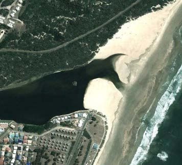
Draft Hartenbos Estuary Management Plan                                               Introduction

It is important to recognize that this document is designed to focus management attention at a
strategic level and does not provide detailed guidance on the day-to-day management actions
required for management of the estuary. Annual Business Plans will have to be developed by the
MBM and Estuary Manager in consultation with the Hartenbos EMF, and should be guided by this
EMP in that major effort should be directed towards priority activities that support the strategic
objectives identified in this plan.

Progress towards achieving the objectives set out in this EMP should be reviewed on an annual basis
by the Hartenbos EMF and focal efforts of the participating agencies adjusted to ensure targets are
met within specified time frames. The Hartenbos EMP should be updated every five years in order
to reflect goals that have been achieved and to accommodate changing priorities.

                                                2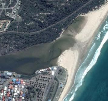
Draft Hartenbos Estuary Management Plan                               Situation Assessment Summary

2 SITUATION ASSESSMENT
2.1.1 Introduction
Recognising the importance of the Hartenbos Estuary and estuaries in South Africa more generally,
the Mossel Bay Local Municipality (MBM) commissioned Anchor Environmental Consultants (Pty)
Ltd. (AEC) to prepare an Estuarine Management Plan (EMP) for the Hartenbos Estuary.

The following executive summary is an extract from the Situation Assessment Report (SAR)
completed during 2015 and provides background material and the context for the development of
the management plan.

2.1.2 Geographic and socio-economic context
The Hartenbos catchment lies within the MBM (part of the Eden District Municipality) in the
Western Cape Province and forms part of the Breede-Gouritz Catchment Management Area. The
Hartenbos River originates in the foothills of the Outeniqua mountains and its tributaries drain a
relatively small area of approximately 205 km2 in south-easterly direction. The Hartenbos River has
a total length of approximately 34 km from the source to the mouth and drains into the Indian
Ocean 7.5 km east of Mossel Bay.

The catchment falls within the Fynbos Biome, but most of the area is transformed and under
agriculture (pasture, wheat and vegetables) or forestry. The catchment has also been invaded by
invasive alien acacias, including Acacia cyclops (rooikrans), especially in the lower reaches of the
estuary. . The mean annual temperature of the Hartenbos catchment is 17°C and is located within a
region of bimodal rainfall, where precipitation peaks in spring and autumn. The average annual
rainfall is 446 mm and is contrasted by 1400 mm mean annual evaporation with a mean annual
runoff (MAR) for the whole catchment of approximately 5.7 million m3.

The geographic trend in economic activity along the catchment is predominately agriculturally based
in the middle and upper reaches and tourism related industry near the mouth. One of the larger
tourism developments is the Afrikaanse Taal en Kultuur Vereniging (Hartenbos ATKV) Holiday Resort,
located at the estuary mouth, which includes permanent holiday cottages, caravan sites and
recreational amenities.

Urban areas in the catchment are almost exclusively in the surroundings of the estuary, while the
lower reaches of the estuary and remaining catchment are dominated by agricultural land. The
average annual growth rate of the MBM population based on the years from 2001-2011 is 2.24%
and pressures on the Hartenbos River system and estuary are likely to increase over time.

2.1.3 Ecological characteristics and functioning
The channel and mouth dynamics of the Hartenbos Estuary have been strongly influenced by
anthropogenic developments in the catchment and have been sporadically managed since the 1970s
when the Hartebeeskuil Dam was built. In the 1970s and 1980s artificial breaching was motivated
primarily by the desire of holiday makers to access holiday facilities on the northern bank. Currently

                                                  3
Draft Hartenbos Estuary Management Plan Situation Assessment Summary
artificial breaching of the estuary mouth by the MBM occurs most frequently in response to severe
water quality deterioration in summer and associated excessive algae growth when the water
becomes stagnant during closed mouth conditions. Reportedly, concerned residents or holiday
makers also occasionally open the estuary illegally for the same reason. The estuary is also dug open
illegally by bait harvesters to reduce water levels and allow easy access to the burrowing sand
prawns. Illegal opening of the mouth in January 2015 is thought to have contributed to a large fish
kill, as the dramatically reduced water levels resulted in higher water temperatures and decreased
dissolved oxygen concentrations. It is currently illegal to breach the river mouth without an
environmental authorisation or a legally recognised breaching protocol and associated management
plan in terms of Government Notice 983 (Activity 19) of the EIA Regulations 2014.
The estuary currently receives some 64% of its natural MAR due to the Hartebeeskuil Dam and water
abstractions downstream of the dam. Controlled water release records show that releases from the
dam have increased since 1988, peaking in 1998 and 2009. Overall, most water is released for
irrigation purposes, followed by downstream river ecology and the least is released for the
maintenance of ecological functioning of the Hartenbos Estuary. Water use for irrigation purposes is
seasonal and is most frequently released from the Hartebeeskuil Dam in low flow months at higher
average volumes compared to the remainder of the year. Ecological releases are much more
constant all year around, but are on average of a much lower volume than releases for irrigation.
Water is seldom released for the estuary, but when releases are made these are usually during the
hot summer months, where very large volumes are released in the hope that those will reach the
estuary.
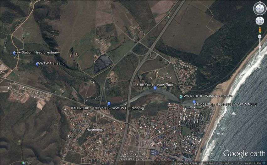
The Regional Waste Water Treatment Works (from hereinafter referred to as the Hartenbos
WWTW) became operational in 1986 and has been discharging effluent into the upper reaches of
the estuary (Figure 3.4). The WWTW has since then been upgraded to more than double the original
treatment capacity from 7.8 to 18 mega litres per day (Swartz et al., 2000). Full capacity has not
been reached to date but approximately 10 mega litres of treated effluent is released into the
estuary per day. This means that the WWTW is discharging 3.45 Mm3 of freshwater to the estuary in
addition to 2.8 Mm3 provided by the current flow regime (MAR). Consequently, the water contained
in the estuary below the WWTW currently exceeds the MAR that was provided by the flow regime
prior to the construction of the Hartebeeskuil Dam by almost 2 Mm3 per year.
Macroalgal blooms have been reported in the Hartenbos Estuary during closed mouth conditions
and form thick algal mats in the estuary. During the night photosynthesis ceases but these algal
continue to respire lowering dissolved oxygen concentrations, whilst the decay of these algal mats
further reduces available oxygen in the water. There are three main types of vegetation associated
with the Hartenbos Estuary: terrestrial vegetation including invasive plants that have encroached
into the riparian zone, intertidal and supratidal salt marsh, and macroalgae. The distribution and
extent of these vegetation types is determined by water levels in the system and salinity.
Benthic invertebrates of the Hartenbos Estuary are dominated by the sandprawn Callichirus kraussi
and the bivalve Loripes clausus. Diversity and abundance is considered to be low relative to other
temporarily open/closed estuaries in the region. The invasive tube worm Ficopomatus enigmatica
has also been reported in the estuary in the 1980s, however, the present day extent and abundance
of this aggressive species is unknown.
4Draft Hartenbos Estuary Management Plan Situation Assessment Summary
A total of 17 fish species have been recorded from the Hartenbos Estuary to date, which is
considered to be low compared to other temporarily open/closed estuaries in the region. During a
survey conducted in October/November 1997 a total of nine species were recorded of which three
taxa were estuarine resident species (Category Ia) and six species were euryhaline marine species
that breed at sea, with juveniles showing varying degrees of dependence on estuaries. The presence
of both estuarine-resident and estuarine-dependent species in the Hartenbos Estuary indicate that
fishes typical of estuarine habitats are supported by this system.
A total of 59 water-associated bird species of nine taxonomic orders, excluding rare vagrant species,
have been recorded at the Hartenbos Estuary to date. The most species-rich taxonomic group is the
Charadriiformes, which include the waders, gulls and terns. The relative contribution of taxa to the
bird numbers on the estuary differs moderately in summer and winter, due to the presence of
migratory birds in summer. There are no important populations of red data species on the estuary,
although wader numbers, especially resident wader numbers have slowly but steadily increased
since 2005. Birds of prey and kingfishers have decreased in abundance, while waterfowl abundance
has increased over time.
2.1.4 Ecosystem services
Estuaries provide a range of services that have economic or welfare value. In the case of the
Hartenbos Estuary, the most important of these are the recreational and tourism values of the
estuary as well as the provision of a nursery area for marine fish. Recreational anglers on the
Hartenbos Estuary are mainly shore anglers. Bait collection (prawn pumping) occurs regularly on the
northern and southern banks of the estuary mouth. Water-contact recreational activities are
uncommon and include occasional canoeing or pedal boating, while motorised boat use is minimal.
The Hartenbos Estuary is not extensively used for bathing due to poor water quality, however dog
walking is a common activity near the mouth.
There may be additional services, such as carbon sequestration, but these are not likely to be of
major value. Hartenbos has been a popular holiday and retirement destination for decades. The
estuary forms part of the beginning of the Garden Route and is also in close proximity to towns such
as George and Mossel Bay, and within easy reach of Cape Town and Port Elizabeth.
2.1.5 Legislation and management issues
The Hartenbos Estuary is a highly disturbed system, which has been manipulated for at least four
decades. The system is currently managed in a state which is quite different from its natural
condition, as has been necessitated by the low-lying developments around the estuary. There are a
number of factors that threaten the future health of the system and hence its biodiversity and
capacity to deliver ecosystem services. The main threats to the system or areas of potential conflict
are as follows:
1. Water quantity and quality
5Draft Hartenbos Estuary Management Plan Situation Assessment Summary
a. Reduction in freshwater inflows due to water storage in the catchment
(Hartebeeskuil Dam) and insufficient controlled releases to maintain the flood
regime of the system;
b. Increased and continuous input of treated freshwater from the WWTW into the
upper reaches of the estuary;
c. Nutrient enrichment resulting from effluent discharges by the WWTW; and
d. Loss of important habitat area such as salt marsh through eutrophication and
stagnation as inadequately treated effluent enters the upper estuary at times and
the mouth remains closed.
2. Land-use and associated disturbance
a. potential for increased residential/resort development around the estuary leading
to change in sense of place and existence value, increased human disturbance of
biota, and damage or loss of estuarine habitat.
3. Unmanaged/illegal artificial breaching of the estuary mouth
a. Water levels in the estuary in summer are low. Unmanaged/illegal artificial
breaching further reduces water levels and results in shallow and isolated ponds
with insufficient dissolved oxygen available to fish and other biota. This issue must
be considered in the context of water quality management.
Little legislation has been designed for estuaries in particular. However, the fact that estuaries
contain freshwater, terrestrial and marine components, and are heavily influenced by activities in a
much broader catchment and adjacent marine area, means that they are affected by a large number
of policies and laws. There is also no specific provision for Estuarine Protected Areas. The National
Departments of Water and Sanitation (DWS) and Environmental Affairs (DEA) are the primary
agencies responsible for estuary management in South Africa with a small amount of responsibility
(fisheries) attributable to the Department of Agriculture Forestry and Fisheries (DAFF).
Environmental management in most instances is devolved to provincial level, aside from water
resources and fisheries which remain a national competency. At a municipal level, by-laws are
passed which cannot conflict with provincial and national laws. Water quality and quantity are
mainly controlled under the National Water Act (Act No. 36 of 1998) (NWA). This makes provision
for an Environmental Reserve which stipulates the quantity and quality of water flow required to
protect the natural functioning of each water resource, including estuaries. The extent to which an
estuary’s functioning is catered for is determined by the designated future management “class”
(where classes A – F describe state of health), called the Ecological Reserve Category (ERC). In future
this will be determined using a recently-developed, holistic classification process. In the interim,
however, the amount of freshwater allocated to estuaries is determined through a “Reserve
Determination” study. The preliminary reserve determination process was recently completed for
the Hartenbos Estuary (and other systems in the Breede-Gouritz Water Management Area). The
estuarine health index score was determined to be 51, giving it a Present Ecological Status (PES) of
Category D. The RDM study also concluded that the Hartenbos Estuary should be managed as a
Recommended Ecological Category (REC) of C (moderately modified) i.e. management should
achieve an improvement in ecological status of the estuary.
The Integrated Coastal Management Act, 2008 (ICMA) requires that a management plan be
developed for each estuary in the country. The National Estuary Management Protocol (NEMP) has
been published in the in terms of ICMA and provides guidance for the management of estuaries
6Draft Hartenbos Estuary Management Plan Situation Assessment Summary
through the development of individual estuarine management plans (such as this one). The NEMP
also outlines a national vision for estuarine management in South Africa, lays out strategic objectives
for effective integrated management of estuaries in this country, and prescribes standards for the
management of estuaries.
The National Biodiversity Assessment (NBA) conducted in 2011 (Van Niekerk and Turpie 2012) did
not recommend the establishment of a protected area in the Hartenbos Estuary but did identify
focus areas for the rehabilitation of the estuary, including alien plant clearance, increasing
freshwater inflow, improving water quality, fixing of inappropriate bank stabilisation and possibly
the removal of the Hartebeeskuil Dam. Interestingly, mouth management and management of
siltation of the estuary were not recommended for the Hartenbos Estuary. It is recommended that
rehabilitation objectives also focus on restoring the aesthetic and scenic value of the Hartenbos
Estuary, which could in part be implemented in conjunction with a public awareness programme.
7Draft Hartenbos Estuary Management Plan Situation Assessment Summary
2.2 Uitvoerende Opsomming
2.2.1 Inleiding
In erkenning van die belangrikheid van die Hartenbos Riviermond en riviermondings meer in die
algemeen in Suid-Afrika, het die Mosselbaai Plaaslike Munisipaliteit (MBM) opdrag gegee aan
Anchor Environmental Consultants (Pty) Ltd. (AEC) om 'n Omgewings Bestuurs Plan (OBP) vir die
Hartenbos monding voor te berei.
Die volgende bestuurs opsomming is 'n uittreksel uit die Situasie Evaluasie Verslag (SAR) wat
gedurende 2015 gedoen is en verskaf agtergrond materiaal en konteks vir die ontwikkeling van die
bestuursplan.
2.2.2 Geografiese en sosio-ekonomiese konteks
Die Hartenbos opvanggebied lê binne die MBM (deel van die Eden Distriksmunisipaliteit) in die Wes-
Kaap en vorm deel van die Breede-Gouritz Opvang Bestuursgebied. Die oorsprong van die
Hartenbos rivier is in die voetheuwels van die Outeniqua berge en sy sytakke dreineer 'n relatief
klein oppervlakte van ongeveer 205 km2 in ‘n suid-oostelike rigting. Die Hartenbos rivier is 'n totale
lengte van ongeveer 34 km vanaf die bron na die mond en dreineer in die Indiese Oseaan, 7,5 km
oos van Mosselbaai.
Die opvanggebied val binne die fynbosbioom maar die grootste deel van die gebied is verander en is
onder landbou (weiveld, graan en groente) of bosbou. Die opvanggebied is ook oorgeneem deur
indringende uitheemse akasias, insluitend Acacia cyclops (rooikrans), veral laer af in die
riviermonding. Die gemiddelde jaarlikse temperatuur van die Hartenbos opvanggebied is 17°C en is
geleë in 'n streek van bimodale reënval, waar neerslae in die lente en herfs piek. Die gemiddelde
jaarlikse reënval is 446 mm en word gekontrasteer deur 1400 mm gemiddelde jaarlikse verdamping
met 'n gemiddelde jaarlikse afloop (MAR) vir die hele opvanggebied van ongeveer 5,7 miljoen m3.
Die geografiese neiging in ekonomiese aktiwiteit langs die opvanggebied is hoofsaaklik landbou-
gebaseer in die middel en boonste dele en is toerismebedryf gebaseer naby die mond. Een van die
groter toerisme-ontwikkelings is die Afrikaanse Taal en Kultuur Vereniging (Hartenbos ATKV)
Vakansie Oord, geleë by die riviermonding, wat permanente vakansie huisies, karavaan staanplekke
en ontspanningsgeriewe insluit.
Stedelike gebiede in die opvanggebied is byna uitsluitlik in die omliggende gebied van die
riviermonding, terwyl die laer dele van die riviermond en oorblywende opvanggebied oorheers word
deur landbougrond. Die gemiddelde jaarlikse groeikoers van die bevolking van die MBM is 2,24%,
gebaseer op die jaar vanaf 2001-2011, en die druk op die Hartenbos Rivier en riviermonding sal
waarskynlik oor tyd toeneem.
2.2.3 Ekologiese eienskappe en funksionering
8Draft Hartenbos Estuary Management Plan Situation Assessment Summary
Die kanaal en mond dinamika van die Hartenbos riviermonding is sterk beïnvloed deur
antropogeniese ontwikkelings in die opvanggebied en is sporadies bestuur sedert die 1970's toe die
Hartebeeskuil Dam gebou is. In die 1970's en 1980's is die kunsmatige oopmaak van die
riviermonding hoofsaaklik gemotiveer deur die begeerte van vakansiegangers om toegang tot
vakansie geriewe op die noordelike oewer te verkry. Huidiglik kom die meeste kunsmatige oopmaak
van die riviermonding by die MBM voor in reaksie op ernstige watergehalte agteruitgang in die
somer en gepaardgaande oormatige alge groei wanneer die water stagnant raak tydens geslote
mond omstandighede. Volgens berigte word die monding om dieselfde rede deur bekommerde
inwoners of vakansiegangers ook soms onwettig oopgemaak. Die monding word ook onwettig
oopgegrawe deur aas stropers om die watervlak te verlaag en maklike toegang tot die grawende
sand garnale te kry. Die onwettige opening van die mond in Januarie 2015 is vermoedelik bydraend
tot die wydverspreide vis sterftes, hoofsaaklik as gevolg van verlaagde water vlakke wat lei tot hoër
water temperature en verlaagde opgeloste suurstof. Dit is tans onwettig om die riviermond oop te
maak sonder 'n omgewings magtiging of 'n wetlik erkende oopmaak protokol en gepaardgaande
bestuursplan ingevolge Staats kennisgewing 983 (Aktiwiteit 19) van die OIB Regulasies 2014.
Die riviermonding ontvang tans sowat 64% van sy natuurlike MAR (afvloei) as gevolg van die
Hartebeeskuil Dam en water abstraksies stroomaf van die dam. Beheerde water vrylating rekords
toon aan dat watervrylatings uit die dam toegeneem het sedert 1988, en gepiek het in 1998 en
2009. In die algeheel word die meeste water vir besproeiingsdoeleindes vrygelaat, gevolg deur
stroomaf rivier ekologie en die minste word vrygelaat vir die Hartenbos riviermonding. Dit blyk dat
water vir besproeiingsdoeleindes seisoenaal is en meer gereeld vrygelaat word in lae-vloei maande
teen hoër gemiddelde volumes in vergelyking met die res van die jaar. Ekologiese watervrylating is
baie meer konstant dwarsdeur die jaar, maar is gemiddeld van 'n veel laer volume as vrylatings vir
besproeiing. Water word selde vrygelaat vir die riviermond maar wanneer dit gedoen word is dit
gewoonlik gedurende die warm somer maande, waar baie groot volumes vrygelaat word in die hoop
dat dit die monding sal bereik.
Die Hartenbos RSW word operasionele in 1986 en word afvalwater vrygestel in die bolope van die
monding (Figuur 3.4). Die RSW is sedertdien opgegradeer vir meer as dubbel die oorspronklike
behandelde hoeveelheid van 7,8 na 18 mega liter per dag (Swartz et al., 2000). Volle kapasiteit is tot
op datum nog nie bereik nie, maar ongeveer 10 mega liter behandelde uitvloeisel word vrygestel in
die monding per dag. Dit beteken die RSW het 'n uitvloei van 3,45 Mm³ varswater na die monding
bykomend tot 2,8 Mm³ wat deur die huidige vloei stelsel (MAR). Gevolglik oorskry die water wat
tans in die monding onder die RSW invloei die MAR van die vloei stelsel voor die bou van die
Hartebeeskuil Dam met byna 2 Mm³ per jaar.
Macroalge-plantegroei is aangemeld in die Hartenbos riviermonding tydens tye wanneer die
monding toe is. Hierdie macroalge vorm dik algematte in die monding, wat die beskikbare suurstof
in die water affekteer. Daar is drie hooftipes plantegroei wat verband hou met die Hartenbos
riviermonding: aardse-plantegroei insluitend indringerplante wat die rivieroewer sone oorskry,
tussengety en supra-gety soutmoeras en macroalge. Die verspreiding en omvang van hierdie
plantegroei tipes word bepaal deur die watervlakke in die sisteem en soutgehalte.
Bentiese ongewerweldes van die Hartenbos riviermonding word oorheers deur die sand garnaal
Callichirus kraussi en die tweekleppige Loripes clausus. Diversiteit en oorvloed word as laag beskou
9Draft Hartenbos Estuary Management Plan Situation Assessment Summary
relatief tot ander tydelik oop/toe riviermondings in die streek. Die indringende buiswurm
Ficopomatus enigmatica in die monding is ook in die 1980's aangemeld maar die huidige omvang en
hoeveelheid van hierdie aggressiewe spesie is onbekend.
Tot op datum is 'n totaal van 17 spesies vis uit die Hartenbos riviermonding aangeteken, wat as laag
beskou word in vergelyking met ander tydelike oop/toe riviermondings in die streek. Tydens 'n
opname wat in Oktober/November 1997 onderneem is, is 'n totaal van nege spesies aangeteken
waarvan drie taksa riviermonding-inwoner spesies (Kategorie Ia) is en ses spesies was euryhaline
mariene spesies wat in die see broei, met jonger weergawes wat wisselende grade van afhanklikheid
van riviermondings toon. Die voorkoms van beide riviermonding-inwoner en riviermonding-
afhanklik spesies in die Hartenbos riviermonding dui daarop dat visse van baie verskillende
lewensiklusse deur hierdie sisteem ondersteun word.
'n Totaal van 59 water-geassosieerde voëlspesies van nege taksonomiese ordes, seldsame swerwer
spesies uitgesluit, is tot op datum by die Hartenbos riviermonding aangeteken (uitgesluit seldsame
swerwers). Die mees spesieryk taksonomiese groep is die Charadriiformes, wat die waadvoëls,
meeue en sterretjies insluit. Die relatiewe bydrae van taksa tot die voëlgetalle op die riviermonding
verskil matig in die somer en winter as gevolg van die teenwoordigheid van trekvoëls in die somer.
Daar is geen belangrike bevolkings van rooi data spesies op die riviermonding, alhoewel waadvoël
getalle, veral inwoner waadvoël getalle, stadig maar seker toegeneem het sedert 2005. Roofvoëls
en visvangers (Kingfishers) het afgeneem in voorkoms terwyl die voorkoms van watervoëls
mettertyd toegeneem het.
2.2.4 Ekosisteem dienste
Riviermondings bied 'n verskeidenheid van dienste wat ekonomiese of welsyn waarde het. In die
geval van die Hartenbos riviermonding, is die mees belangrikste van hierdie die ontspanning- en
toerisme waardes van die riviermonding sowel as die voorsiening van 'n kweek gebied vir vis.
Ontspannings-hengelaars by die Hartenbos riviermonding is hoofsaaklik strand-hengelaars. Aas
versameling (garnale pomp) kom gereeld op die noordelike en suidelike oewers van die riviermond
voor. Water-kontak ontspanningsaktiwiteite is ongewoon en sluit in kano of pedaal boot, terwyl
gemotoriseerde boot gebruik minimal is. Die Hartenbos riviermonding word nie vir swem
doeleindes gebruik nie as gevolg van swak watergehalte maar die loop van honde is 'n algemene
aktiwiteit naby die mond.
Daar mag bykomende dienste wees, soos koolstofsekwestrasie, maar hierdie sal waarskynlik nie van
groot waarde wees nie. Die riviermonding is vir dekades al 'n gewilde vakansie en aftree
bestemming. Die riviermonding vorm deel van die begin van die Tuinroete en is ook in die nabyheid
van dorpe soos George en Mosselbaai en binne maklike bereik van Kaapstad en Port Elizabeth.
2.2.5 Wetgewing en bestuur kwessies
Die Hartenbos riviermonding is 'n hoogs versteurde sisteem, wat vir ten minste vier dekades
gemanipuleer is. Die sisteem word tans bestuur in 'n toestand wat heelwat verskil van sy natuurlike
toestand, soos reeds genoodsaak is deur die laagliggende ontwikkelings rondom die riviermonding.
Daar is 'n aantal faktore wat die toekomstige gesondheid van die sisteem dreig en vandaar die
biodiversiteit en die vermoë om ekosisteem dienste te lewer. Die belangrikste bedreigings vir die
sisteem of gebiede van potensiële konflik is soos volg:
10Draft Hartenbos Estuary Management Plan Situation Assessment Summary
1. Water hoeveelheid en gehalte
a. Vermindering in varswater invloei weens die opgaar van water in die opvanggebied
(Hartebeeskuil Dam) en onvoldoende beheerde vrylatings om die vloed sisteem in
stand te hou;
b. Toename en deurlopende invloei van behandelde varswater uit die RIOOL WERKE in
die bolope van die monding;
c. Voedingstof verryking as gevolg van die uitvloeisel faktor van die RIOOL WERKE; en
d. Verlies van belangrike habitat gebied soos soutmoeras deur eutrofikasie en
stagnasie soos onvoldoende behandelde uitvloeisel die boonste riviermonding
ingaan en die mond toe bly.
2. Grondgebruik en gepaardgaande versteuring
a. potensiaal vir verhoogde residensiële/oord ontwikkeling rondom die riviermond lei
tot die verandering in gevoel van plek en bestaan waarde, toename in menslike
versteuring van biota en skade of verlies aan riviermonding habitat.
3. Onbestuurde/onwettige kunsmatige oopmaak van die riviermond
a. Watervlakke in die riviermonding is laag in die somer. Onbestuurde/onwettige
kunsmatige oopmaak veroorsaak nog meer vlak en geïsoleerde dammetjies met
onvoldoende opgeloste suurstof beskikbaar vir visse. Hierdie kwessie moet in die
konteks van watergehalte bestuur oorweeg word.
Min wetgewing is ontwerp vir riviermondings in die besonder. Nieteenstaande, die feit dat
riviermondings varswater, land- en mariene komponente bevat, en sterk beïnvloed word deur
aktiwiteite in 'n baie breër opvanggebied en aangrensende mariene gebied, beteken dat hulle deur
'n groot aantal beleide en wette geraak word. Daar is ook geen spesifieke voorsiening vir
Riviermonding Beskermde Gebiede nie. Die Nasionale Departement van Waterwese en Sanitasie
(DWS) en Omgewingsake (DEA) is die primêre agentskappe verantwoordelik vir riviermonding
bestuur in Suid-Afrika met 'n klein hoeveelheid van die verantwoordelikheid (vissery) toeskryfbaar
aan die Departement van Landbou, Bosbou en Visserye (DAFF). Omgewingsbestuur in die meeste
gevalle is oorgedra aan provinsiale vlak, behalwe waterbronne en visserye wat 'n nasionale
bevoegdheid bly. Op 'n munisipale vlak word verordeninge (by-wette) aangeneem wat nie in konflik
is met die provinsiale en nasionale wette nie. Watergehalte en die hoeveelheid daarvan word
hoofsaaklik beheer onder die Nasionale Waterwet (Wet 36 van 1998) (NWA). Dit maak voorsiening
vir 'n Omgewing reservaat wat die hoeveelheid en gehalte van water vloei bepaal wat benodig word
om die natuurlike funksionering van elke waterbron, insluitende riviermondings te beskerm. Die
mate tot wat ‘n riviermonding se funksionering voorsiening voor gemaak word, word bepaal deur
die aangewese toekomstige bestuur "klas" (waar klasse A - F toestand van gesondheid beskryf),
genaamd die Ekologiese Reserwe Kategorie (ERK). In die toekoms sal dit bepaal word met behulp
van 'n onlangs ontwikkelde, holistiese klassifikasie proses. In die interim word die aantal varswater
wat aan riviermondings toegeken word bepaal deur 'n "Reserwe Bepaling" studie. Die voorlopige
reserwe bepaling proses is onlangs voltooi vir die Hartenbos riviermonding (en ander stelsels in die
Breede-Gouritz Water bestuursgebied). Die riviermonding gesondheid indeks telling was bepaal om
51, wat dit 'n Huidige Ekologiese Status (PES) van Kategorie D gee. Die RDM studie het ook bevind
dat die Hartenbos riviermonding bestuur moet word as 'n Aanbevole Ekologiese Kategorie (REC) van
C (matig aangepas).
11Draft Hartenbos Estuary Management Plan Situation Assessment Summary
Die Wet op Geïntegreerde Kusbestuur, 2008 (ICMA) vereis dat 'n bestuursplan ontwikkel word vir
elke riviermonding in die land. 'n Konsep Nasionale Riviermonding Bestuur Protokol (NEMP) is
ingevolge Die wet of Geïntegreerde Kusbestuur, 2008 (ICMA) gepubliseer en verskaf leiding vir die
bestuur van riviermondings deur die ontwikkeling van individuele riviermondings bestuurplanne
(soos hierdie een). Die NEMP beskryf ook 'n nasionale visie vir riviermondings in Suid-Afrika, lê
strategiese doelwitte uit vir effektiewe geïntegreerde bestuur van riviermondings in hierdie land, en
skryf standaarde voor vir die bestuur van riviermondings.
Die Nasionale Biodiversiteit Assessering (NBA) wat in 2011 gedoen is (Van Niekerk en Turpie 2012)
het nie die vestiging van 'n beskermde gebied in die Hartenbos Riviermonding aanbeveel nie, maar
het fokusareas geïdentifiseer vir die rehabilitasie van die riviermonding, insluitend uitheemse plant
verwydering, die verhoging van varswater invloei, verbetering van die watergehalte, herstel van
onvanpaste oewer stabilisering en moontlik die verwydering van die Hartebeeskuil Dam. Interessant
genoeg, is die mondbestuur en bestuur van toeslikking van die riviermonding nie aanbeveel vir die
Hartenbos riviermonding nie. Dit word aanbeveel dat rehabilitasie doelwitte ook fokus op die
herstel van die estetiese en skilderagtige waarde van die Hartenbos riviermonding, wat gedeeltelik
in samewerking met 'n openbare bewustheid program geïmplementeer kan word.
12Draft Hartenbos Estuary Management Plan Estuary Management Vision & Objectives
3 VISION
A vision is a high level statement which defines the strategic intent of a management intervention.
The following vision was developed for the Hartenbos Estuary using stakeholder input collected after
a stakeholder meeting held in June 2015.
“The Hartenbos Estuary has good water quality that supports a
healthy and functioning ecosystem, which contributes towards
economic growth and facilitates improved recreational use for
the benefit of present and future generations.”
4 ESTUARY MANAGEMENT OBJECTIVES
Key management objectives for the Hartenbos Estuary were identified subsequent to the
stakeholder workshop held in Hartenbos, in June 2015 and were reconfirmed at a meeting held in
Hartenbos on 2 February 2016. These objectives are displayed in the form of a circular diagram in
Figure 1 as none are considered as being of greater importance than any other.
4.1 Improve estuary health
Use of freshwater resources and land in the Hartenbos River catchment must be effectively
managed so as to improve the quality and quantity of freshwater reaching the estuary. Water
quality within the estuary must also be managed through improving effluent quality of the WWTW.
4.2 Maximise economic benefits
Increasing the recreational value of the estuary will directly benefit local and regional economic
growth. The estuary must also be managed to maximize the value of ecosystem goods and services
delivered in the long term, ensuring an equitable balance among local, regional and national
benefits.
4.3 Restore aesthetic value
The aesthetic value of the estuary needs to be restored through improving water quality and
quantity in the system. This will reduce water stagnation, excessive algae proliferation as well as
odours associated with biological decay. Furthermore, removal of alien vegetation and
rehabilitation of degraded riparian areas will play an important role in enhancing the aesthetic value
of the estuary.
13Draft Hartenbos Estuary Management Plan Estuary Management Vision & Objectives
4.4 Increase awareness
Residents and visitors need to be made aware of the importance and economic value of the estuary,
be knowledgeable regarding regulations applicable to the system, and understand the rationale for
management measures and interventions.
4.5 Harmonious and effective governance
Institutional roles and responsibilities pertaining to the management of the estuary must be clearly
defined, and coordination between responsible institutions improved and maintained.
Figure 1 Management Objectives for the Hartenbos Estuary.
14Draft Hartenbos Estuary Management Plan Strategies
5 STRATEGIES TO MEET MANAGEMENT OBJECTIVES
Strategies required for meeting the management objectives are summarized in Figure 2. Each
management objective requires a number of strategies. Note that some of the management
objectives form part of the strategy for other management objectives.
Estuary health can be improved through a multitude of strategies. Water quality must be improved
by reducing and/or treating waste water inputs to the estuary, effective catchment management
and improved agricultural practices. Estuary mouth management, securing adequate freshwater
supplies to the estuary as well as rehabilitation and alien plant clearing within the Estuarine
Functional Zone (EFZ) (defined as below the 5 m contour) will be essential to complement efforts to
reduce pollution. A clear zonation plan is required for the system to prevent further encroachment
of development onto the estuary and to ensure successful implementation of short-term and long-
term rehabilitation goals. Implementing rules and regulations through compliance monitoring will
be essential in achieving this objective. Monitoring and research into estuary health and human
utilisation of the estuary should be undertaken to ensure adequate information is available to track
changes in the health of the system and to inform best management of the system in future.
Economic objectives as well as the management of current and future development will be subject
to coastal management lines and guidelines that improve and safeguard both development and the
estuary. These guidelines will need to be integrated into regional and local development plans.
Ecotourism growth will require improving visitor facilities that draw people to the area and will also
depend on future developments being sensitive to, or even supporting rehabilitation efforts within
the estuary and its catchment.
Improving ecosystem function, especially the value of water quality improvement that natural
estuary functioning can provide, should be prioritised for improving the recreational value of the
estuary. At the same time, it must be recognised that the natural flow regime of the Hartenbos
system has been modified to the extent that natural mouth functioning is not possible and that
management is required to mitigate flood risk and water quality deterioration. The estuary mouth
should therefore be managed to improve the recreational value and ecological functioning of the
estuary, especially during peak visitor periods. The zonation plan will assist in the management of
recreational uses and ensure that those will not be in conflict with rehabilitation efforts. The
accessibility to the estuary for recreational users needs be improved (i.e. formalised) through the
implementation of facilities (e.g. boardwalks) and amenities.
To achieve harmonious and effective governance, an Estuary Management Forum (EMF) comprising
representatives from various stakeholder groups (e.g. the Hartenbos Conservancy, the Bird Club,
farming associations in the catchment, etc.) and government agencies (local, provincial and national
departments) responsible for various aspects of management of the estuary must be established for
the Hartenbos Estuary. The EMF must oversee the implementation of the Estuary Management Plan
(EMP) and ensure that local communities and stakeholders have input into and are informed about
the management of the estuary.
15Figure 2 Strategies to meet management objectives for the Hartenbos Estuary.
Draft Hartenbos Estuary Management Plan                                    Key Result Areas and MAPs

6 KEY RESULT AREAS AND MANAGEMENT ACTION PLANS
Key result areas (KRA) are management objectives and strategies (Refer to Figure 2) that were
chosen to become focus areas for action. A management action plan was compiled for each KRA,
which details at least one KRA strategy that should be implemented by means of various actions and
assessed using quantitative and measurable targets, limits or thresholds (Table 1-Table 8). The
following KRAs were identified for the Hartenbos Estuary:

    1.   Improve estuary health
    2.   Improve water quality
    3.   Effective mouth management
    4.   Improve recreational value
    5.   Improve aesthetic value
    6.   Increase awareness and appreciation of the Hartenbos Estuary
    7.   Research and monitoring
    8.   Harmonious and effective governance

6.1 Key Result Area 1: Improve estuary health
A desktop reserve determination study was conducted for the Hartenbos Estuary in 2015 under the
auspices of the Resource Directed Measures (RDM) Directorate of the Department of Water and
Sanitation (DWS 2015). As part of the reserve determination study, estuary health was assessed in
terms of the degree to which the current state resembles the natural condition. Considering
hydrology, hydrodynamics and mouth condition, water quality, physical habitat alteration and the
ability of the habitat to support fauna and flora, the estuary was assigned a Present Ecological Status
(PES) of Category D. Furthermore, the Hartenbos Estuary was considered to be “important” (score =
66/100) when considering its size, habitat performance, zonal type rarity and biodiversity
importance (Turpie and Clark 2007). The Hartenbos Estuary did not form part of the core set of
priority estuaries in need of protection to achieve biodiversity targets in the National Estuary
Biodiverstiy Plan for the National Biodiversity Assessment (Turpie et al. 2012). Having been
identified as an “important” system, it was recommended that the estuary should be managed in a
Category C (Recommended Ecological Category) (DWS 2015) (Please refer to Ecological
Specifications and Thresholds of Potential Concern in Appendix 3).

Anthropogenic pressures on the system are manifold and those that contribute most to a current
negative trajectory of change were identified as (1) reduced base flow to the estuary from the
catchment, (2) poor water quality, (3) improper mouth management (illegal and emergency
breaches), as well as (4) poor condition of riparian areas and wetlands (DWS 2015).

Freshwater flows reaching the Hartenbos Estuary have been strongly influenced by anthropogenic
developments in the catchment, of which the most significant were the construction of the
Hartebeeskuil Dam and the Hartenbos Regional Waste Water Treatment Works (WWTW). The
Hartebeeskuil Dam was constructed in 1970 and is situated 12 km upstream of the estuary,
impounding a large proportion of the MAR from the catchment. Consequently, the estuary currently
receives only 64% of its natural MAR and overall variability in the flow regime shows little

                                                  17
Draft Hartenbos Estuary Management Plan Key Result Areas and MAPs
resemblance to the natural condition, where the frequency and magnitude of floods has decreased
significantly.
The Hartenbos Regional Waste Water Treatment Works (WWTW) became operational in 1986 and
since then has been discharging effluent into the upper reaches of the estuary. The WWTW has
since been upgraded to more than double the original treatment capacity from 7.8 to 18 mega litres
per day (Swartz et al. 2000). Full capacity has not been reached to date but approximately 10 mega
litres of treated effluent is released into the estuary per day. This means that the WWTW is
discharging an estimated 3.45 Mm3 of freshwater to the estuary in addition to 2.8 Mm3 provided by
the current flow regime (MAR). Consequently, the estuary below the WWTW currently receives
approximately 2 Mm3 of water per year in excess of the MAR that was provided by the flow regime
prior to the construction of the Hartebeeskuil Dam. Although the WWTW has more than replaced
the MAR impounded by the Hartebeeskuil Dam, the water is of poor quality and has been
contributing significantly to the deterioration of estuary health (Lemley et al. 2015).
Alien invasive plant species are prevalent in the Hartenbos Estuarine Functional Zone, as well as in
the catchment as a whole. Alien invasive plants are known to have greater water requirements
compared to indigenous vegetation and rehabilitation of invaded areas throughout the catchment
could assist in increasing water availability in the estuary. Clearing efforts are currently not focused
on the Hartenbos River catchment as the Hartebeeskuil Dam does not contribute towards the supply
of potable water to the Mossel Bay municipal area. Systematic alien clearing within the EFZ could
contribute towards reducing erosion of the banks and improving health of riparian vegetation and
improve wetland areas situated within the flood plain.
Historically, artificial manipulation of the Hartenbos Estuary mouth has been used as a means to
reactively mitigate impacts of anthropogenically induced changes to the natural flow regime of the
Hartenbos system on the ecological functioning of the estuary and recreational utility. No formal
mouth management protocol is currently available for the Hartenbos Estuary and the development
of such a protocol, as well as the prevention of illegal breaches is thought to be pivotal in improving
estuary health.
The priority of this first generation EMP is to reverse the negative trajectory of change of the
Hartenbos Estuary health and therefore two of the above mentioned key pressures, namely
improving water quality and effective mouth management (addressing point (2) and (3)), were
identified as separate KRAs (Section 6.2 and 6.3). The Management Action Plan (MAP) for improving
estuary health thus only includes detailed actions concerning adequate freshwater supplies for the
estuary and eradication of alien invasive species (addressing point (1) and (4)).
Although Ecological Specifications and respective TPCs for sediment dynamics, fauna and flora are
not directly addressed through the above MAPs, it is anticipated that efforts to reverse the negative
trajectory of change over the next five years will contribute towards managing the Hartenbos
Estuary within a PES Category C.
18You can also read