COMMUNITY RISK ASSESSMENT - Squamish-Lillooet Regional ...
←
→
Page content transcription
If your browser does not render page correctly, please read the page content below
COMMUNITY RISK
ASSESSMENT
Squamish-Lillooet Regional District
Abstract
This Community Risk Assessment is a component of the SLRD Comprehensive
Emergency Management Plan. A Community Risk Assessment is the foundation for any
local authority emergency management program. It informs risk reduction strategies,
emergency response and recovery plans, and other elements of the SLRD emergency
program.

Evaluating risks is a requirement mandated by the Local Authority Emergency
Management Regulation. Section 2(1) of this regulation requires local authorities to
prepare emergency plans that reflects their assessment of the relative risk of
occurrence, and the potential impact, of emergencies or disasters on people and
property.

SLRD Emergency Program
info@slrd.bc.ca
Version: 1.0
Published: January, 2021
SLRD Community Risk Assessment
                                                          SLRD Emergency Management Program

Executive Summary
     This Community Risk Assessment (CRA) is a component of the Squamish-Lillooet Regional District (SLRD)
Comprehensive Emergency Management Plan and presents a survey and analysis of known hazards, risks and
related community vulnerabilities in the SLRD. The purpose of a CRA is to:

         •     Consider all known hazards that may trigger a risk event and impact communities of the SLRD;
         •     Identify what would trigger a risk event to occur; and
         •     Determine what the potential impact would be if the risk event did occur.

    The results of the CRA inform risk reduction strategies, emergency response and recovery plans, and other
elements of the SLRD emergency program.

     Evaluating risks is a requirement mandated by the Local Authority Emergency Management Regulation.
Section 2(1) of this regulation requires local authorities to prepare emergency plans that reflect their assessment
of the relative risk of occurrence, and the potential impact, of emergencies or disasters on people and property.

        This CRA focuses on the risks associated with the highest frequency and consequence hazards present in
the SLRD, namely:

         •     Wildland interface fire;
         •     Flooding (riverine, overland, freshet, dam failure and storm surge);
         •     Geotechnical (debris flow, debris flood and landslide);
         •     Severe storm and subsequent utility failure;
         •     Earthquake;
         •     Hazardous material release (including incidents arising from transportation accidents); and
         •     Climate change effects.

          These are not the only hazards present in the SLRD and the full range of hazards is considered in this CRA.
Further, hazards can be interconnected and have cascading effects that increase the overall severity of a risk
event. For example, a wildfire on a steep slope can decrease slope stability, leading to erosion that contributes to
debris flows and flooding.

           Climate change is both a separate hazard and one that interacts with many other hazards, increasing
both the frequency and severity of risk events. Changing weather patterns are already contributing to increased
effects from flood, wildfire, and landslide events in Canada and these changes are predicted to continue. The
cumulative effect of changing and interrelated hazards presents a challenge for community risk assessment, and
for this reason a CRA is considered a “snapshot in time” and should be updated periodically. Population growth in
the SLRD will also affect the risk profile of some communities.

          In Electoral Area A, wildfire and geotechnical hazards present the highest risks, along with a degree of
geographic isolation from larger population centers. Communities are vulnerable to being cut off from main
evacuation routes if these become compromised by wildfire or geotechnical events such as debris flows. However,
this relative isolation can also a protective factor, contributing to resilience with independent drinking water,
wastewater and other systems, along with a strong sense of community. Climate change effects may lead to
increased risk of drought conditions and water security concerns.

         Electoral Area B has a similar hazard profile to Area A but with generally less geographic isolation
(excepting the Yalakom Valley). The flood and geotechnical risks in Seton Portage are of particular note. Landslides

 Version 1.0                                         January, 2021                                             1/67
SLRD Community Risk Assessment
                                                          SLRD Emergency Management Program
from the Whitecap, Pete’s, Bear, and Spider Creeks all have potential to impact that community with damage from
debris or by diversion of creeks and rivers into inhabited areas. Wildfire is an additional hazard in the hot, dry
summers and fire starts ignited by dry lightning are not uncommon.

          Electoral Area C is at risk of flood, interface fire, and geotechnical hazard events. Volcanic hazard is also
present, with Area C located in the Garibaldi Volcanic belt and proximal to the Mount Meager volcanic complex,
north of Pemberton. The Pemberton Valley has flood risk from the Lillooet, Birkenhead and Green rivers. This flood
risk was increased by the 2010 Capricorn Creek landslide on Mount Meager, the largest landslide in recorded
Canadian history. Sediment from this event is currently moving downstream, causing the river channel to become
shallower, reducing its flow capacity and rendering current flood protection infrastructure less effective than
originally designed. Further, landslides from Mt Meager that are orders of magnitude larger than the 2010 event
are possible. An additional landslide risk is presented by Mount Currie, where a number of areas of slope instability
have been identified.

          The hazards in Electoral Area D that present the highest risk are flood and interface fire, with debris flows
also being a notable risk. Updated floodplain mapping in 2019 for the Upper Squamish Valley found that
inundation of most of the valley floor can be expected in a 50-year return period flood event. Wildfires present an
existing hazard that is increasing over time with climate change. Hotter, drier and longer summer weather is drying
the traditionally lower risk rainforest environment of the coastal mountains. Most Area D communities are
situated in or below forested areas, and some communities could experience substantial population growth due to
the proximity to Vancouver.

        The SLRD has a diverse natural hazard profile, and the risks they present to communities can be
compounded by interconnected and cascading effects, including climate change effects. The SLRD will continue to
develop and update emergency management plans and policies consistent with the most current community risk
information.

 Version 1.0                                         January, 2021                                              2/67
SLRD Community Risk Assessment
                                                                                        SLRD Emergency Management Program

Contents
Executive Summary .......................................................................................................................................................1
Contents ........................................................................................................................................................................3
Introduction ...................................................................................................................................................................9
     Key Definitions and Common Abbreviations ...........................................................................................................10
PART ONE: HAZARDS IN THE SLRD ..............................................................................................................................11
1.      Index of Hazards Affecting the SLRD ...................................................................................................................11
     1.1.        Climate Change ..........................................................................................................................................12
     1.2.        Dam Failure ................................................................................................................................................12
     1.3.        Drought ......................................................................................................................................................13
     1.4.        Earthquake .................................................................................................................................................13
     1.5.        Epidemic / Pandemic..................................................................................................................................14
     1.6.        Flooding......................................................................................................................................................15
     1.6.1.      Riverine ......................................................................................................................................................15
     1.6.2.      Freshet .......................................................................................................................................................16
     1.6.3.      Storm Surge ................................................................................................................................................17
     1.6.4.      Outburst Flood ...........................................................................................................................................17
     1.7.        Geotechnical Hazards.................................................................................................................................17
        1.7.1 Debris flow ..................................................................................................................................................18
        1.7.2 Rock Avalanches .........................................................................................................................................19
     1.8.        Hazardous Material Release / Transportation ...........................................................................................19
     1.9.        Storm / Utility Outage ................................................................................................................................19
     1.10.       Tsunamis and Displacement Waves ...........................................................................................................20
     1.11.       Volcanic ......................................................................................................................................................20
     1.12.       Wildland Interface Fire ...............................................................................................................................20
PART TWO: ELECTORAL AREA RISK ASSESSMENT .......................................................................................................22
2.      Electoral Area A ...................................................................................................................................................22
     2.1.        Overview – People, Environment and Geography .....................................................................................22
     2.2.        Electoral Area Demographics .....................................................................................................................23
     2.3.        Community Profiles ....................................................................................................................................23
        2.3.1.       Gold Bridge & Bralorne ..........................................................................................................................23
        2.3.2.       Gun Lake ................................................................................................................................................23
        2.3.3.       Tyaughton Lake ......................................................................................................................................24

  Version 1.0                                                                  January, 2021                                                                            3/67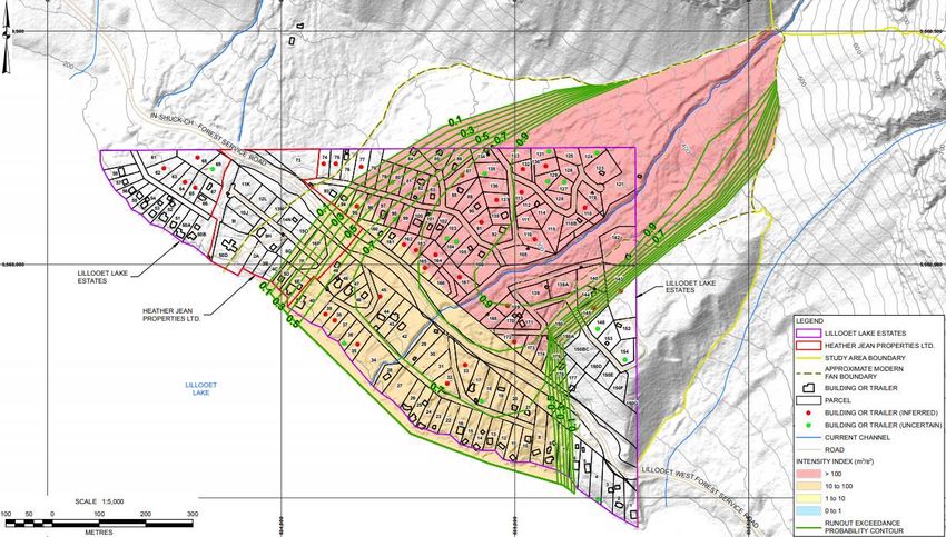
SLRD Community Risk Assessment
                                                                                      SLRD Emergency Management Program
       2.3.4.       Marshall Lake Area ................................................................................................................................24
     2.4.       Critical Infrastructure .................................................................................................................................24
       2.4.1.       Electrical Power Systems .......................................................................................................................24
       2.4.2.       Water and Wastewater Systems ...........................................................................................................24
       2.4.3.       Major Roads and Access Routes ............................................................................................................25
       2.4.4.       Air Transportation..................................................................................................................................25
       2.4.5.       Schools ...................................................................................................................................................25
     2.5.       Response Capabilities.................................................................................................................................25
       2.5.1.       Ambulance Services ...............................................................................................................................25
       2.5.2.       Fire Services ...........................................................................................................................................25
     2.6.       Emergency Response Partners ...................................................................................................................25
       2.6.1.       First Nations ...........................................................................................................................................25
     2.7.       Economy.....................................................................................................................................................26
     2.8.       Hazard, Risk and Vulnerability Analysis......................................................................................................26
     2.9.       Hazards.......................................................................................................................................................27
       2.9.1.       Flood – Moderate to Major ...................................................................................................................27
       2.9.2.       Geotechnical Hazard - Debris Flow / Landslide .....................................................................................27
       2.9.3.       Interface Fire ..........................................................................................................................................27
       2.9.4.       Storm / Utility Failure ............................................................................................................................28
       2.9.5.       Earthquake.............................................................................................................................................28
       2.9.6.       Hazardous Material Release / Transportation .......................................................................................28
3.     Electoral Area B ...................................................................................................................................................29
     3.1.       Overview – People, Environment and Geography .....................................................................................29
     3.2.       Electoral Area Demographics .....................................................................................................................30
     3.3.       Community Profiles ....................................................................................................................................30
       3.3.1.       Seton Portage ........................................................................................................................................30
       3.3.2.       Yalakom Valley .......................................................................................................................................31
       3.3.3.       Texas Creek ............................................................................................................................................31
       3.3.4.       Fountain Valley ......................................................................................................................................31
       3.3.5.       Pavilion Lake ..........................................................................................................................................31
     3.4.       Critical Infrastructure .................................................................................................................................32
       3.4.1.       Electrical Power Systems .......................................................................................................................32
       3.4.2.       Water and Wastewater Systems ...........................................................................................................32
       3.4.3.       Major Roads and Access Routes ............................................................................................................32

 Version 1.0                                                                  January, 2021                                                                            4/67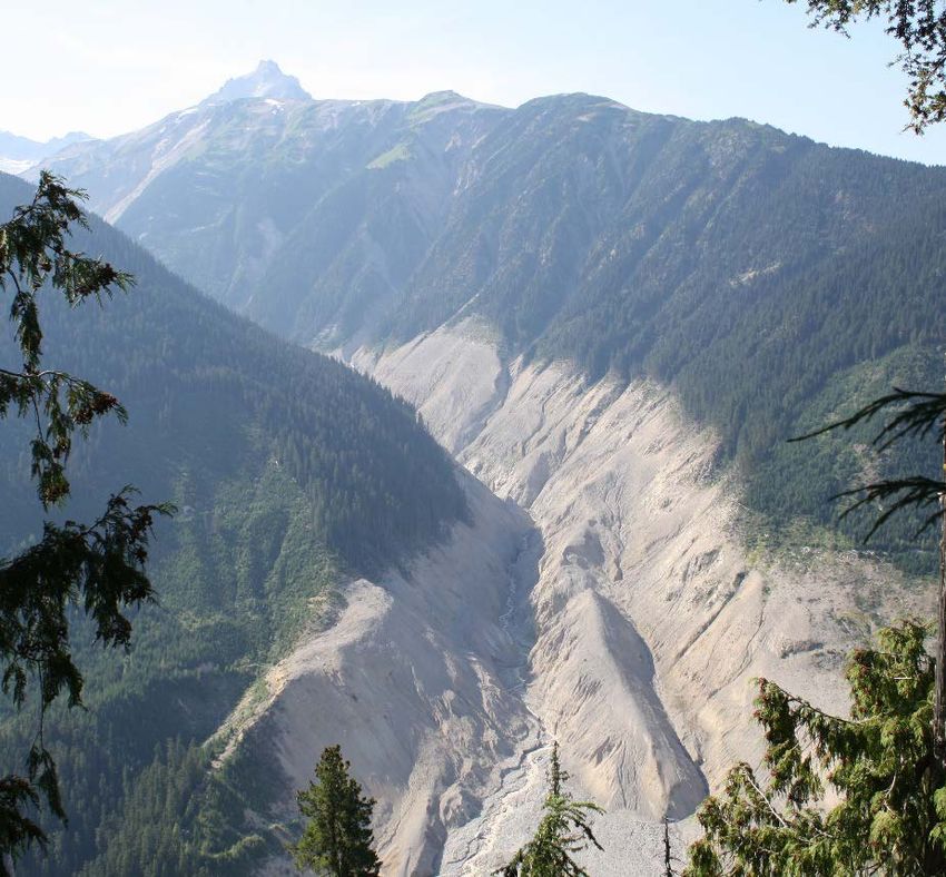
SLRD Community Risk Assessment
                                                                                       SLRD Emergency Management Program
       3.4.4.       Air Transportation..................................................................................................................................32
       3.4.5.       Schools ...................................................................................................................................................32
       3.4.6.       Health Care Facilities .............................................................................................................................33
       3.4.7.       Seniors ...................................................................................................................................................33
     3.5.       Response Capabilities.................................................................................................................................33
       3.5.1.       Police......................................................................................................................................................33
       3.5.2.       Ambulance Services ...............................................................................................................................33
       3.5.3.       Fire Services ...........................................................................................................................................33
     3.6.       Volunteer Response Capabilities................................................................................................................33
       3.6.1.       Search and Rescue .................................................................................................................................33
       3.6.2.       Emergency Social Services / Red Cross ..................................................................................................33
       3.6.3.       Victim Services .......................................................................................................................................34
     3.7.       Emergency Response Partners ...................................................................................................................34
       3.7.1.       First Nations ...........................................................................................................................................34
       3.7.2.       Municipalities.........................................................................................................................................34
     3.8.       Economy.....................................................................................................................................................34
     3.9.       Hazard, Risk and Vulnerability Analysis......................................................................................................35
     3.10.      Hazards.......................................................................................................................................................35
       3.10.1.          Flood ..................................................................................................................................................35
       3.10.2.          Geotechnical Hazard - Debris Flow / Landslide .................................................................................36
       3.10.3.          Interface Fire .....................................................................................................................................38
       3.10.4.          Storm / Utility Failure ........................................................................................................................38
       3.10.5.          Hazardous Material Release / Transportation ..................................................................................38
4.     Electoral Area C ...................................................................................................................................................39
     4.1.       The History .................................................................................................................................................39
     4.2.       Natural Environment and Geographical Setting ........................................................................................40
     4.3.       Electoral Area Demographics .....................................................................................................................40
     4.4.       Community Profiles ....................................................................................................................................40
       4.4.1.       McGillivray .............................................................................................................................................40
       4.4.2.       Ponderosa ..............................................................................................................................................41
       4.4.3.       D'Arcy & Devine .....................................................................................................................................41
       4.4.4.       Mount Currie & Pemberton Fringe ........................................................................................................41
       4.4.5.       Birkenhead Lake Estates ........................................................................................................................42
       4.4.6.       Pemberton Meadows ............................................................................................................................42

 Version 1.0                                                                   January, 2021                                                                            5/67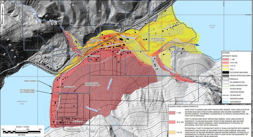
SLRD Community Risk Assessment
                                                                                   SLRD Emergency Management Program
   4.4.7.       Birken .....................................................................................................................................................42
   4.4.8.       Lillooet Lake Estates & Heather Jean Properties ...................................................................................42
   4.4.9.       WedgeWoods ........................................................................................................................................43
 4.5.       Critical Infrastructure .................................................................................................................................43
   4.5.1.       Electrical Power Systems .......................................................................................................................43
   4.5.2.       Water and Waste Water Systems ..........................................................................................................44
   4.5.3.       Major Roads and Access Routes ............................................................................................................44
   4.5.4.       Flood Protection Assets .........................................................................................................................44
   4.5.5.       Water Transportation ............................................................................................................................44
   4.5.6.       Air Transportation..................................................................................................................................45
   4.5.7.       Mental Health ........................................................................................................................................45
   4.5.8.       Schools ...................................................................................................................................................45
   4.5.9.       Health Care Facilities .............................................................................................................................46
   4.5.10.          Seniors ...............................................................................................................................................46
 4.6.       Response Capabilities.................................................................................................................................46
   4.6.1.       Police......................................................................................................................................................46
   4.6.2.       Ambulance Services ...............................................................................................................................46
   4.6.3.       Fire Services ...........................................................................................................................................46
 4.7.       Volunteer Response Capabilities................................................................................................................46
   4.7.1.       Search and Rescue .................................................................................................................................46
   4.7.2.       Emergency Social Services / Red Cross ..................................................................................................47
 4.8.       Emergency Response Partners ...................................................................................................................47
   4.8.1.       First Nations ...........................................................................................................................................47
   4.8.2.       Municipalities.........................................................................................................................................47
   4.8.3.       Pemberton Valley Dyking District ..........................................................................................................47
 4.9.       Economy.....................................................................................................................................................47
 4.10.      Hazard, Risk and Vulnerability Analysis......................................................................................................48
 4.11.      Hazards.......................................................................................................................................................48
   4.11.1.          Flood ..................................................................................................................................................48
   4.11.2.          Geotechnical Hazard - Landslide / Debris Flow .................................................................................50
   4.11.3.          Interface Fire .....................................................................................................................................51
   4.11.4.          Storm / Utility Failure ........................................................................................................................51
   4.11.5.          Earthquake ........................................................................................................................................52
   4.11.6.          Hazardous Material Release / Transportation ..................................................................................52

Version 1.0                                                                January, 2021                                                                            6/67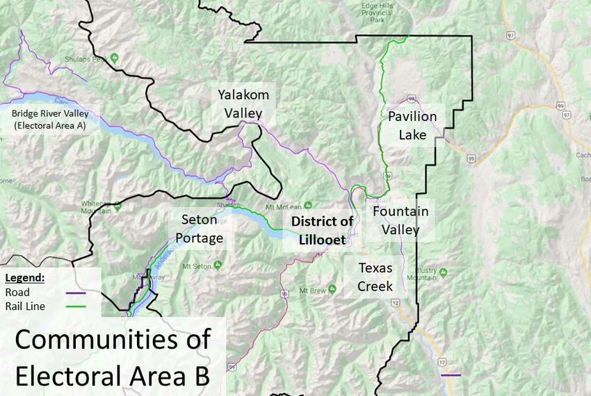
SLRD Community Risk Assessment
                                                                                       SLRD Emergency Management Program
5.     Electoral Area D ...................................................................................................................................................52
     5.1.       The History .................................................................................................................................................52
     5.2.       Natural Environment and Geographical Setting ........................................................................................53
     5.3.       Electoral Area Demographics .....................................................................................................................53
     5.4.       Community Profiles ....................................................................................................................................53
       5.4.1.       Black Tusk Village & Pine Crest Estates..................................................................................................53
       5.4.2.       Britannia Beach & Furry Creek ...............................................................................................................54
       5.4.3.       Upper Squamish Valley ..........................................................................................................................54
       5.4.4.       Tunnel Station ........................................................................................................................................54
       5.4.5.       Ring Creek ..............................................................................................................................................54
       5.4.6.       Porteau Cove .........................................................................................................................................54
     5.5.       Critical Infrastructure .................................................................................................................................55
       5.5.1.       Electrical Power Systems .......................................................................................................................55
       5.5.2.       Water & Wastewater Systems ...............................................................................................................55
       5.5.3.       Major Roads and Access Routes ............................................................................................................55
       5.5.4.       Water Transportation ............................................................................................................................55
       5.5.5.       Air Transportation..................................................................................................................................56
       5.5.6.       Mental Health ........................................................................................................................................56
       5.5.7.       Schools ...................................................................................................................................................56
       5.5.8.       Health Care Facilities .............................................................................................................................56
       5.5.9.       Seniors ...................................................................................................................................................56
     5.6.       Response Capabilities.................................................................................................................................57
       5.6.1.       Police......................................................................................................................................................57
       5.6.2.       Ambulance Services ...............................................................................................................................57
       5.6.3.       Fire Services ...........................................................................................................................................57
     5.7.       Volunteer Response Capabilities................................................................................................................57
       5.7.1.       Search and Rescue .................................................................................................................................57
       5.7.2.       Royal Canadian Marine Search and Rescue ...........................................................................................57
       5.7.3.       Emergency Social Services / Red Cross ..................................................................................................58
       5.7.4.       Victim Services .......................................................................................................................................58
     5.8.       Emergency Response Partners ...................................................................................................................58
       5.8.1.       First Nations ...........................................................................................................................................58
       5.8.2.       Municipalities.........................................................................................................................................58
     5.9.       Economy.....................................................................................................................................................58

 Version 1.0                                                                   January, 2021                                                                            7/67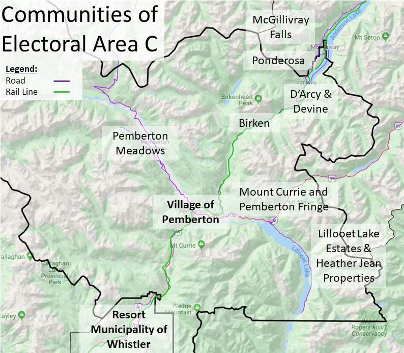
SLRD Community Risk Assessment
                                                                                       SLRD Emergency Management Program
     5.10.      Hazard, Risk and Vulnerability Analysis......................................................................................................59
     5.11.      Hazards.......................................................................................................................................................59
       5.11.1.          Flood ..................................................................................................................................................59
       5.11.2.          Geotechnical Hazard - Debris Flow / Landslide .................................................................................60
       5.11.3.          Interface Fire .....................................................................................................................................61
       5.11.4.          Earthquake ........................................................................................................................................61
       5.11.5.          Storm / Utility Failure ........................................................................................................................62
       5.11.6.          Hazardous Material Release / Transportation ..................................................................................62
6.     Figures and Tables ...............................................................................................................................................63
7.     References ...........................................................................................................................................................65

 Version 1.0                                                                   January, 2021                                                                            8/67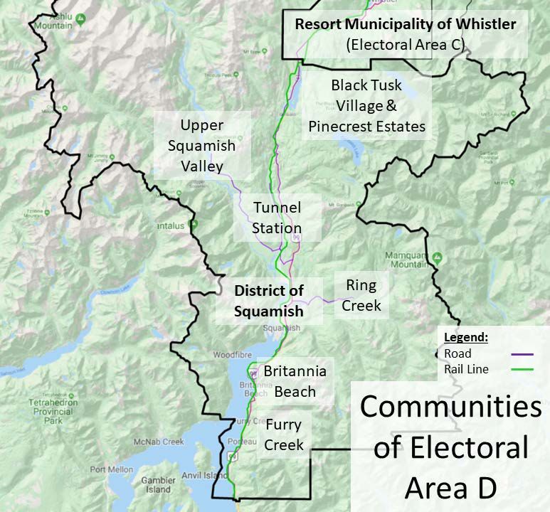
SLRD Community Risk Assessment
                                                         SLRD Emergency Management Program

Introduction
         The Emergency Program Act (1996) provides the legislative framework for emergency management in
British Columbia. The development of community emergency plans is further mandated by the British Columbia
Local Authority Emergency Management Regulation (1995), 2(2) whereby:

          Each municipal council and each board of a regional district that qualifies as a local authority
          under section 2 (1) of the Act must reflect in its local emergency plan, unless it is documented
          elsewhere,

                 (a) the commitment of the local authority to provide policy guidance and direction to
                 the emergency management organization established by that local authority under
                 section 6 of the Act, and

                 (b) the procedures by which that guidance and direction is to be provided.

The purpose of a Community Risk Assessment (CRA) is to consider all known hazards that may trigger a risk event
and impact communities of the SLRD, identify what would trigger a risk event to occur, and determine what the
potential impact would be if the risk event did occur. The results of the CRA inform risk reduction strategies,
emergency response and recovery plans, and other elements of the SLRD emergency program.

                                                                                    This CRA is organized by each
                                                                                    electoral area (A, B, C and D),
                                                                                    recognizing the distinct
                                                                                    demographic nature, inherent
                                                                                    strengths, and potential
                                                                                    vulnerabilities in each of those.
                                                                                    It focuses on the six hazards
                                                                                    that either by frequency or
                                                                                    magnitude, pose the highest
                                                                                    risk to the safety of people who
                                                                                    live, work and recreate in the
                                                                                    SLRD. These hazards are
                                                                                    wildland interface fire, flood,
                                                                                    landslide/debris flow/debris
                                                                                    flood, severe storm/utility
                                                                                    failure, earthquake, and
                                                                                    hazardous material release.
                                                                                    Additionally, the forecast
                                                                                    effects of climate change on
                                                                                    existing hazards are reviewed.

                                                                                    Figure 1 – Electoral Areas and
                                                                                    Municipalities of the SLRD

 Version 1.0                                        January, 2021                                              9/67
SLRD Community Risk Assessment
SLRD Emergency Management Program
Key Definitions and Common Abbreviations
Emergency A present or imminent event that requires prompt coordination of actions
concerning persons or property to protect the health, safety or welfare of people,
or to limit damage to property or the environment.
Hazard A potentially damaging physical event, phenomenon or human activity that may
cause the loss of life or injury, property damage, social and economic disruption
or environmental degradation.
Resilience A measure of how well prepared and equipped a community is physically, socially,
economically and environmentally to minimize the impact of or cope with
hazards. Resilient capacity is built through a process of empowering citizens,
responders, organizations, communities, governments, systems and society to
share the responsibility to keep hazards from becoming disasters.
Risk Risk in the context of emergency management is the likelihood or probability that
there will be loss of life or property or damage to the environment and the likely
size or severity of the impact or loss.
Risk Event A risk event is a hazard actualized: a wildfire, flood, landslide, other geophysical
phenomena, or human-induced accident that manifests with negative impact to
people, the environment or the economy.
Vulnerability The conditions determined by physical, social, economic and environmental
factors or processes, which increase the susceptibility of a community to the
impact of hazards.
Table 1 – CRA Key Definitions
ALARP As Low As Reasonably Practicable
CEP Community Emergency Plan
CRA Community Risk Assessment
CWPP Community Wildfire Protection Plan
DNV District of North Vancouver
EMBC Emergency Management BC
FSR Forest Service Road
HazMat Hazardous Materials
IPCC International Panel on Climate Change
MFLNRORD Ministry of Forests Lands and Natural Resource Operations and Rural
Development
NRCAN Natural Resources Canada
NSEM North Shore Emergency Management
OCP Official Community Plan
SAR Search and Rescue
Table 2 – CRA Common Abbreviations
Version 1.0 January, 2021 10/67SLRD Community Risk Assessment
SLRD Emergency Management Program
PART ONE: HAZARDS IN THE SLRD
Public Safety Canada maintains the Canadian Disaster Database, which references 60 different hazards across
three main hazard groups (natural, technological and conflict related) and 13 sub-groups, excluding war. Although
all the hazards listed have at least a theoretical possibility of occurring in the SLRD, this community risk assessment
has focused on those where there is evidence of greater exposure to the hazard type. The complete reference
table of all hazards recognized by Public Safety Canada can be found here:
https://www.publicsafety.gc.ca/cnt/rsrcs/cndn-dsstr-dtbs/rfrnc-tbl-smbls-dfntns-en.aspx
1. Index of Hazards Affecting the SLRD
Hazard Risk*
Climate Change High
Dam Failure Low
Drought Moderate
Earthquake – moderate to severe Low-Moderate
Epidemic Low-Moderate
Flood: Freshet Low-Moderate
Flood: Riverine Moderate-High
Flood: Outburst Low
Flood: Storm Surge Low*
Geotechnical: Debris Flow, Debris Flood – moderate to Moderate
severe
Geotechnical: Rock Avalanche – moderate to severe Low*
Hazardous Material Release / Transportation Low
Storm / Utility Outage – moderate to severe Low-Moderate
Tsunami Low-moderate
Volcanic Low
Wildland Interface Fire Moderate-Severe
*Note that risk may vary considerably from one electoral area and community to another, and that a low risk
event may still occur and with severe impacts. Refer to Part Two of this document for more area specific risk
assessment.
Table 3 – Index of Hazards Affecting the SLRD
Version 1.0 January, 2021 11/67SLRD Community Risk Assessment
SLRD Emergency Management Program
1.1. Climate Change
Climate change has the potential to affect the risk posed by hazards, including those described above, and
set the conditions for more severe events and cascading events where hazard effects interact. For
example, increases in the frequency and severity of atmospheric rivers (intense rainfall events) high above
the earth’s surface increase the chances of storm flooding (NHC, 2019, p. iii), high levels of precipitation
also affect slope stability (BGC, 2018a, p. iii) increasing risk from debris flow and flood hazards. Further,
unusually hot and dry conditions increase wildfire risk (Abbot & Chapman, 2018). Globally, climate change
is expected to have wide ranging effects on ecosystems across the world. The Technical Summary of the
International Panel on Climate Change’s Special Report on Climate Change and Land describes the
potential for desertification, drought, changing precipitation patterns and other forms of extreme
weather that are assessed as likely to be felt across communities worldwide (IPCC, 2019, p. 88).
Figure 2 – Changes in
global climate lead to
local conditions of
extreme weather
(Source: Government
of Canada)
1.2. Dam Failure
BC Hydro operates a number of hydro-electric power generating stations in the SLRD, which are fed by
water reservoirs created by dams. There is a low risk, high consequence assessed dam failure hazard that
would affect communities downstream due to the resulting high-volume of water suddenly released
through water channels. Dams are located at Daisy Lake in Electoral Area D and in Electoral Areas A and B
the Bridge River Power System utilizes the LaJoie Dam, upstream of Gold Bridge, and the Terzaghi Dam,
upstream of Moha. BC
Hydro maintains detailed
emergency response plans
and conducts regular
emergency response
exercises with emergency
management stakeholders
including the SLRD, and
maintains dams to the
standards set out in the
Dam Safety Regulation
(2016).
Figure 3 – BC Hydro Bridge
River Power System
(Source: BC Hydro, 2019)
Version 1.0 January, 2021 12/67SLRD Community Risk Assessment
SLRD Emergency Management Program
1.3. Drought
A drought is a prolonged shortage of water in the environment. Meteorological drought is caused by a
lack of precipitation. Hydrological drought is brought on by the depletion of aquifers, lakes and reservoirs
for reasons other than lack of precipitation. Agricultural drought is caused by soil erosion or poorly
planned irrigation that results in a shortfall of water available to crops.
In all cases, drought has the potential for significant economic, social and environmental impact
throughout the SLRD. Drought harms agriculture and tourism businesses, and reduces opportunity for
water-based recreational activities. Drought also exacerbates wildfire risk because it dries and increases
the flammability of potential fire fuel sources. Drought can be made worse by the changing weather
patterns brought on by the El Niño Southern Oscillation phase and by climate change.
Drought is a recurrent event in western Canada, sometimes lasting multiple years. The most significant
drought in recent years lasted from 1999 to 2005, with most significant impact in Alberta and
Saskatchewan. BC experiences drought in various regions on an almost annual basis. All of the SLRD has
the potential to be affected by drought, but the drier climate of Electoral Areas B is particularly
susceptible. With climate change, areas that have not historically felt the effects of drought may find
themselves more affected by this hazard.
The Ministry of the Environment and Climate Change Strategy is the lead provincial organization for
managing drought in BC, and works closely with local governments, first nations, and other provincial
agencies in planning and response. The BC Ministry of Agriculture provides advice and drought
management tools to farmers and ranchers affected by drought or loss of water.
1.4. Earthquake
The SLRD is exposed to a wide range of seismic hazard threats related to active tectonics along the North
American Plate Margin. “Source zones for earthquake events include the interface between oceanic crust
of the Juan De Fuca Plate (Cascadia subduction zone), the down-going slab of oceanic crust as it sinks
beneath western North America (Benioff zone), and interlocking networks of faults in the overriding North
American Plate that accommodate incremental strain and displacement along the Canada subduction
zone boundary (Crustal Faults)” (Journey et. al, 2015, p.197). Ground shaking, liquefaction, and
earthquake triggered landslides represent the most significant direct hazard threats and the extent of
damage will depend on the magnitude, depth and type of seismic event. Earthquakes can result in a
number of cascading effects including fires started by downed electrical lines, damaged drinking and
waste water infrastructure and damage to communication infrastructure.
Small earthquakes are common in Southwest BC and some are not even felt. However, severe
earthquakes are possible and in the Cascadia subduction zone, and geological evidence suggests that
large subduction ‘megathrust’ earthquakes have struck the BC coast every 300-800 years (Natural
Resources Canada, 2019). As the fault ruptures, tsunami, severe ground shaking and landslides are
expected, with many aftershocks possible and widespread damage predicted. Shallow crustal fault
earthquakes in the North American Plate also have potential to cause significant damage to communities
because these earthquakes occur close to the earth’s surface (Natural Resources Canada, 2011).
Liquefaction is an effect of crustal earthquakes and only occurs in saturated soil. The seismic event
creates shaking that causes the subsequent failure of water saturated sediment. Effects are most
commonly observed in low-lying floodplain areas near bodies of water such as rivers, lakes bays and
Version 1.0 January, 2021 13/67SLRD Community Risk Assessment
SLRD Emergency Management Program
oceans. Historically, liquefaction has caused extensive amounts of damage around the world and is a
major contributor to urban seismic risk. Deep intraslab earthquakes in the Benioff zone also occur, but are
less likely to cause damage to communities because of their depth (City of Vancouver, 2020). The highest
earthquake risk areas are closest to the Pacific Ocean coast in Electoral Areas C and D, with the risk
tending to reduce further inland (Natural Resources Canada, 2015).
A severe earthquake has the
potential to cause sudden and
catastrophic damage, destroying
structures, disrupting utilities,
severing transportation lines, and
death and injury from falling
debris. Severe earthquakes are a
low probability, high consequence
event, which means that it is
prudent to effectively plan for and
mitigate this risk wherever
possible, including adherence to
building codes relating to seismic
standards, household emergency
plans, and business continuity
plans.
Figure 4 – Simplified seismic
hazard map of British Columbia
(Source: Natural Resources
Canada, 2015)
1.5. Epidemic / Pandemic
An epidemic is the rapid spread of infectious disease to a large number of people within a population in a
short period of time. Aside from the obvious direct impact to people’s health, epidemics can also have
significant economic and social impacts. A pandemic is an infectious disease that has spread around the
world. Infectious diseases often disproportionately affect young children, seniors, or people at increased
risk due to other medical conditions. This, however, is not always the case. In 2009, the H1N1 “Swine Flu”
spread to an estimated 10-20 million people worldwide and is notable in that it posed significant risk for
people in otherwise good health.
Vancouver Coastal Health, Interior Health and the BC Centre for Disease Control are responsible for
monitoring disease threats to SLRD constituents.
Epidemics and infestations can also involve plants and non-human animals. These can have significant
negative impact on agricultural businesses, and food security where such events become widespread,
reducing supply and increasing prices. Plant and animal epidemics in wildlands can have cascading effects
throughout ecosystems, which in turn can impact human communities. Even small outbreaks of high-risk
diseases in agriculture can have significant economic impact because farmers may be required to
quarantine and potentially destroy a large number of livestock in an effort to contain the disease. In 2003,
the Canadian Food Inspection Agency identified a cow in Northern Alberta with bovine spongiform
Version 1.0 January, 2021 14/67SLRD Community Risk Assessment
SLRD Emergency Management Program
encephalopathy, a.k.a., “Mad Cow Disease”. Precautionary measures designed to prevent the spread cost
over $1 billion in income support for farmers. Plant and animal epidemics in the wild can have a cascading
effect throughout the ecosystem, and potentially exacerbate other hazards. For example, a plant disease
can kill forests and provide dry fuel for wildfire.
The Canadian Food Inspection Agency is responsible for monitoring livestock. Other provincial and federal
agencies monitor disease threats within their area of expertise.
1.6. Flooding
Overland flooding is the most expensive disaster in Canada (Public Safety Canada, 2019). It occurs when
rivers and other bodies of water overflow onto dry land. Traditionally, overland flood insurance has not
been available to Canadians for their private residencies. This, however, is changing over time and
overland flood insurance is becoming more readily available (Insurance Bureau of Canada, 2017). These
new insurance offerings will have implications for the way British Columbians would receive Disaster
Financial Assistance (DFA) from the provincial government. “If a flooding disaster occurs and DFA is
authorized for a disaster event, an applicant who could reasonably and readily have purchased overland
flood insurance would NOT be eligible for DFA” (EMBC, 2016).
1.6.1. Riverine
Many communities within the SLRD, as with other parts of Canada, have developed in the flat
and fertile lands of river valley floodplains. These water channels can pose flood hazard to
nearby communities, particularly during high-water events. Heavy rains can cause storm flooding
as the watershed becomes saturated and precipitation accumulates in low-laying areas,
especially during rain on snow events.
Channel aggradation is a hydrological phenomenon that occurs when sediment from debris flows
accumulates in water channels, reducing their capacity to contain high water levels. Over time,
this reduces the effectiveness of flood protection infrastructure as the sediment raises water
levels above current embankments. This sedimentation and the associated increased flood risk
has potential to occur in rivers throughout the SLRD’s mountainous environment, but has been
particularly problematic in the Lillooet River following the 2010 Mount Meager landslide. A full
analysis of this event and its implications for nearby communities is found in the NHC report
titled Lillooet River Floodplain Mapping (2018).
Climate change is correlated with future flood risk globally (International Panel on Climate
Change, 2020) and has the potential to increase flow rates in SLRD water channels such as the
Lillooet River (NHC, 2018, p. 48). Torrential downpours and unseasonal or extreme events may
become more common in the SLRD, increasing flood risk to communities. During the autumn
months typically associated with heavy rainfall events, the BC River Forecast Centre’s Coastal Fall
Flood Ensemble Estimation (COFFEE) Model provides regular flood forecasts. This is
supplemented with weather bulletins issued by Environment and Climate Change Canada and
inter-agency coordination teleconferences hosted by Emergency Management British Columbia
(EMBC).
Version 1.0 January, 2021 15/67SLRD Community Risk Assessment
SLRD Emergency Management Program
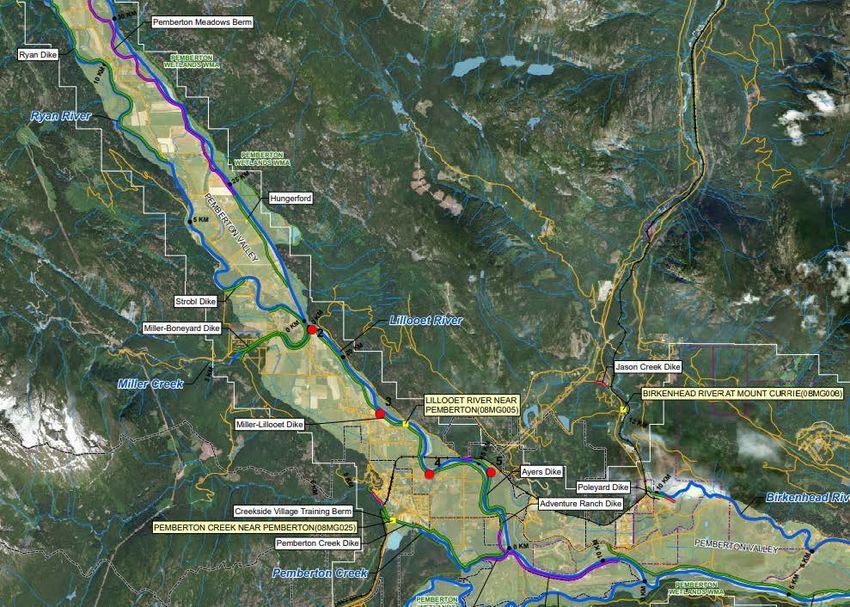
Figure 5 – Projected inundation from a 200-Year Flood event on the Lillooet River Lower Reach,
depicting the Village of Pemberton, Pemberton Meadows, Mount Currie and the Pemberton
Fringe in Electoral Area C (Source: NHC, 2019)
1.6.2. Freshet
Freshet flood is caused when a sudden occurrence of warm temperatures rapidly melts snow and
ice, turning it to liquid water at a faster rate that can be absorbed within the confines of existing
water channels (MFLNRORD, 2019, p. 10). In British Columbia, freshet floods have typically
occurred during the main spring thaw of mountain snow in the months of April to July (TranBC,
2011). The SLRD and EMBC generally
refer to the BC River Forecast Centre’s
Channel Links Evolution Efficient
Routing (CLEVER) Model to monitor
freshet hazards during this time of
year. In times of higher freshet risk,
EMBC hosts inter-agency
teleconferences with presentations by
subject matter experts to assist with
freshet event preparation and
response.
Figure 6 – Freshet flooding onto a
highway in BC. (Source: Tranbc, 2011)
Version 1.0 January, 2021 16/67You can also read