DRAFT - 2018 Hazard, Risk and Vulnerability Assessment - Bowen Island
←
→
Page content transcription
If your browser does not render page correctly, please read the page content below

Hazard, Risk and Vulnerability
          Assessment
                        2018

                        FT
                       RA
                D

Photo by Jason Wilde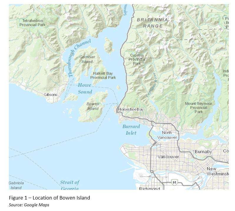
Contents
SECTION 1: INTRODUCTION ............................................................................................................................................. 1
    Hazard Risk and Vulnerability Assessment Overview ............................................................................2
    Scope & Methodology..........................................................................................................................................2
    Risk Assessment ..................................................................................................................................................... 4
    Overview of Hazards............................................................................................................................................ 5
BOWEN ISLAND MUNICIPALITY OVERVIEW ............................................................................................................9
SECTION 2: VULNERABILITY ...........................................................................................................................................10
    Social Vulnerability .............................................................................................................................................. 10
         Language Groups ............................................................................................................................................................... 10
         Age Groups ............................................................................................................................................................................ 10
         Non-Residents ........................................................................................................................................................................ 11
    Economic Vulnerability ....................................................................................................................................... 11
    Environmental Vulnerability ............................................................................................................................. 12
    Physical Vulnerability .......................................................................................................................................... 12
         Critical Response and Recovery Facilities ............................................................................................................. 12
    Critical Infrastructure .......................................................................................................................................... 13
         Energy ....................................................................................................................................................................................... 13
         Communications ................................................................................................................................................................. 14
         Finance ..................................................................................................................................................................................... 16
         Health Care ............................................................................................................................................................................ 16
         Food ........................................................................................................................................................................................... 16
         Water......................................................................................................................................................................................... 17
              Municipal Water ...................................................................................................................................................................................... 17
              Non-Municipal Water ........................................................................................................................................................................... 17
         Transportation ..................................................................................................................................................................... 18
         Safety ........................................................................................................................................................................................ 19
         Government ........................................................................................................................................................................... 19
SECTION 3: RESPONSE ORGANIZATIONS ............................................................................................................... 20
    Fire and Rescue ..................................................................................................................................................... 20
    Police.......................................................................................................................................................................... 21
    Ambulance ............................................................................................................................................................. 22
    Search and Rescue .............................................................................................................................................. 22
SECTION 4: EMERGENCY SUPPORT AND PREPAREDNESS ORGANIZATIONS ........................................ 23
    Bowen Island Municipality Emergency Program .................................................................................... 23
    Emergency Operations Centre (EOC) ........................................................................................................ 23
    Public Works Department ............................................................................................................................... 24
    Parks and Environment Department ........................................................................................................... 24
    Bowen Island Public Notification System (BowENS) ............................................................................ 25
    Amateur Radio....................................................................................................................................................... 25
    Emergency Support Services ......................................................................................................................... 25
    Neighbourhood Emergency Resource Persons (NERPs) ..................................................................... 25
SECTION 5: PRIORITY HAZARDS OVERVIEW ......................................................................................................... 26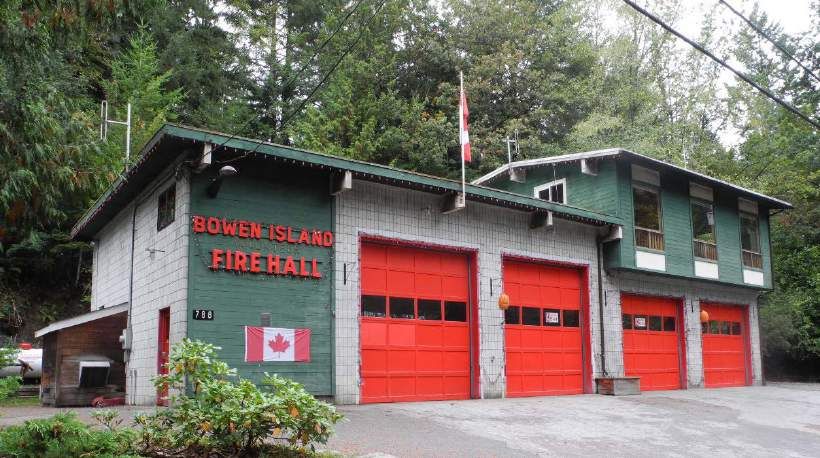
All Hazards Recommendations ..................................................................................................................... 26
          Municipal Readiness......................................................................................................................................................... 26
          Outreach and Education ................................................................................................................................................ 26
          Evacuation Planning ......................................................................................................................................................... 26
PRIORITY HAZARDS........................................................................................................................................................... 26
     Earthquake .............................................................................................................................................................. 26
          Recommendations..............................................................................................................................................................27
     Structure Fire ......................................................................................................................................................... 27
          Recommendations............................................................................................................................................................. 28
     Wildland Urban Interface (WUI) Fire ........................................................................................................... 28
          Recommendations............................................................................................................................................................. 29
     Epidemic and Pandemic ................................................................................................................................... 29
          Recommendations............................................................................................................................................................. 30
     Rockfall ..................................................................................................................................................................... 30
          Recommendations.............................................................................................................................................................. 31
     Marine Accident ................................................................................................................................................... 31
          Hazardous Materials Spills ............................................................................................................................................ 31
          Infrastructure Damage ..................................................................................................................................................... 31
          Recommendations............................................................................................................................................................. 32
     Extreme Weather Event & Power Outage ................................................................................................. 32
          Recommendation ............................................................................................................................................................... 33
NEXT STEPS ........................................................................................................................................................................... 33
APPENDIX A – RISK QUANTIFICATION INDEX ...................................................................................................... 34
APPENDIX B – BOWEN ISLAND FIRE DEPARTMENT APPARATUS INVENTORY ...................................... 35
APPENDIX C – BOWEN ISLAND HRVA UPDATE PROCESS ............................................................................... 38
APPENDIX D – BOWEN ISLAND HRVA RECOMMENDATIONS ....................................................................... 40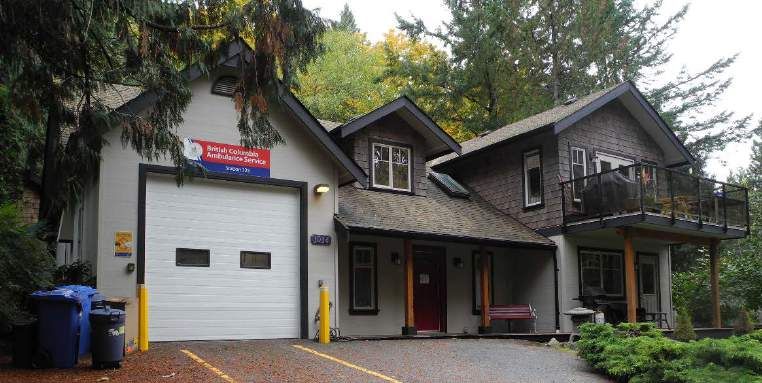
INTRODUCTION

                           Section 1: Introduction
EmergeX Planning Inc. (EmergeX) originally conducted this Hazard Risk and Vulnerability
Assessment (HRVA) for the Bowen Island Municipality in 2007. An update was conducted in
2017 by the Emergency Program Coordinator and Emergency Program Management
Committee and approved by the Emergency Program Executive Committee and Council in
2018. Further details on the 2017/2018 update process are available in Appendix C.

An HRVA is a critical part of every emergency program and is a requirement mandated by
the Local Authority Emergency Management Regulation of the BC Emergency Program Act.
Section 2(1) of this regulation requires local authorities to prepare emergency plans that
reflect the local authority’s assessment of the relative risk of occurrence and the potential
impact on people and property of the emergencies or disasters that could affect all or any
part of the jurisdictional area for which the local authority has responsibility.

No government has unlimited resources allowing them to plan for every hazard event
possible, therefore some form of ranking is required when deciding which hazards are most
important to plan for. Based on the risk rankings completed, 29 hazards that could affect the
Bowen Island Municipality were identified. This assessment identifies the risk that each
hazard presents to the Municipality, thereby allowing Bowen Island to plan for mitigation,
response, and recovery efficiently within budgetary and other constraints. A consolidated
list of recommendations can be found in Appendix D.

The information presented in this assessment can be used by the Bowen Island Municipality
to:
    • Update its emergency plan.
    • Allocate resources for risk mitigation of applicable hazards beginning with the
       highest-risk hazards.
    • Enhance community preparedness.
    • Prepare budgets for cost-effective, on-going emergency planning.

This assessment uses both quantitative and qualitative methods to determine risk ratings for
various hazards, with each hazard being assigned a relative risk ranking. The results of this
assessment identify the following eight hazards as priority risks to the Municipality as a
whole:

 Earthquake                  Wildland Urban            Power Outage           Marine
                             Interface Fire                                   Accident

 Epidemic or Pandemic        Rockfall                  Extreme Weather        Structure Fire

The Risk Quantification Index in Appendix A shows the relative ranking of all hazards
analyzed. These rankings were determined using EmergeX Best Practices methodology
combined with insight from local experts and emergency personnel; it therefore may not be
identical to risks assigned using other methods or criteria.

                                                                                                1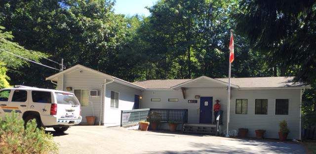
INTRODUCTION

Hazard Risk and Vulnerability Assessment Overview
Considering hazards individually may lead to a skewed set of priorities for action. It is
equally important to consider the severity of possible impacts from the hazard as well as
the frequency or likelihood of a hazard event occurring. The combination of severity and
likelihood is termed the level of risk.

In determining the severity of a hazard event, a community’s vulnerability must be examined.
Vulnerability is defined as people, property, infrastructure, industry and resources, or
environments that are particularly exposed to adverse impact from a hazard event.

Likelihood reflects the frequency of occurrence for a particular hazard event and can range
from rare events occurring every 200 years to more frequent events, which usually have a
number of recorded incidents. A Hazard Risk and Vulnerability Assessment examines the
hazards that may impact a community and the risk that each hazard event poses to the
community.

Scope & Methodology
This HRVA is designed to provide an assessment of the hazards that may present risks to the
Bowen Island Municipality. The objective of the HRVA is to:
    • Investigate prominent natural and human-caused events, and
    • Identify any threats that may require a timely and coordinated response to protect
       lives, property, and reduce economic losses.

The intent of this Hazard Risk and Vulnerability Assessment is to provide a basis from which
local planners, politicians, and responders can update the Municipality’s emergency plan,
allocate resources for risk mitigation, enhance community preparedness, and prepare
budgets for cost-effective, on-going emergency planning.

This assessment is based on both primary and secondary sources, and at times relies on
anecdotal evidence. Both quantitative and qualitative methods are used to determine
hazard ratings for the area of interest. It is worth noting that the assessment – because it is
qualitative and quantitative – includes subjective components; duplication of this
assessment by third parties may not yield exactly the same results.

The scope of this assessment will cover the geographic area of Bowen Island. Factors
considered in developing a list of hazards for the Bowen Island Municipality include:
demographics, geography, economy, transportation modes and routes, weather and
climate. In selecting these events for consideration, BIM acknowledges the potential that
other hazards may exist; the hazards identified in this assessment are considered more likely
to impact the Municipality than others.

This assessment takes an ‘all hazards’ approach, meaning both natural and anthropogenic
hazards that may impact Bowen Island are considered. The methods and tools used to
conduct this assessment are adherent to and used in conjunction with the standards
outlined by Emergency Management British Columbia’s (EMBC) Hazard Risk and

                                                                                                  2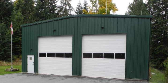
INTRODUCTION

Vulnerability Analysis Tool Kit. 1 Contextual and background information pertaining to the
Bowen Island Municipality is contained in Sections 2-4. Following these, Section 5 details
and evaluates priority hazards as stipulated by EMBC.

Each hazard was evaluated based on the likelihood of occurrence (Table 1) and severity of
its impact (Table 2). The severity of a given hazard is the sum of the impact of four factors:
people, property, the environment and the economy/society.

                        Table 1- Likelihood Rating for Occurrence of Hazards
                     LIKELIHOOD OF OCCURRENCE                                    SCORE

    Highly unlikely or anticipate less frequently than 1 in 200 years            1
    101-200 yrs occurrence                                                       2
    26-100 yrs occurrence                                                        3
    6-25 yrs occurrence                                                          4
    2-5 yrs occurrence                                                           5
    Once a year or more occurrence                                               6

The categories of impact for each factor were individually ranked on a numeric scale from
least to the most severe (Table 2). The purpose of this ranking system is to adhere to the
priorities of the British Columbia Emergency Management System (BCEMS) response goals,
which guide decision makers in prioritizing response activities. Although the goals are listed
in order of priority, “personnel take all available information into account when determining
incident-specific priorities.”2 It is worth noting that “these goals can be interpreted in
different ways based on the operational requirements of each incident. For example, it may
be determined that the best way to reduce suffering is to protect housing (essential
infrastructure) as no other shelter is available.” 3 The BCEMS response goals are:
    1. Ensure the health and safety of all responders
    2. Save lives
    3. Reduce suffering
    4. Protect public health
    5. Protect Infrastructure
    6. Protect property
    7. Protect the Environment
    8. Reduce social and economic losses

To determine which hazards are of priority for Bowen Island, a Risk Tolerance Boundary is
determined following the same criteria as used above. A comparison of the risk scores for
each hazard against the Risk Tolerance Boundary score provided the basis for determining
priority hazards.

1
  Emergency Management British Columbia. 2004. Step-by-Step HRVA Toolkit.
2
  Emergency Management British Columbia. 2016. BC Emergency Management System.
3
  Ibid

                                                                                                 3
INTRODUCTION

Risk Assessment
This section of the report examines the hazards that may impact people and property in the
Municipality and the risk that each hazard event poses. A quantitative assessment of the risk
each hazard poses is summarized in the Risk Quantification Index (Appendix A). The Risk
Tolerance value is calculated by multiplying severity by likelihood. A Risk Tolerance
Boundary of 28 points was established based on an evaluation of an acceptable level of risk
to Bowen Island. When the risk tolerance of a hazard exceeds 28, the hazard poses an
unacceptable level of risk and is discussed as a priority hazard. It is important to note that
many different combinations of criteria values are possible, and even with a high severity
ranking the hazard may still fall below the Risk Tolerance Boundary (depending on
likelihood), and vice versa.

No community has unlimited resources allowing them to plan for every hazard event
possible. Therefore, the purpose of determining a Risk Tolerance Boundary is to determine
which hazards are of the highest priority for mitigation. Even though this report has
determined a list of priority hazards, all hazards should be addressed from highest to lowest
risk in the order of their priority; hazards above the Risk Tolerance Boundary warrant review
and development of mitigation actions to reduce the risk to an acceptable level.

                                                                                                 4
INTRODUCTION

                               Table 2- Severity of Impact

         CATEGORIES                          CRITERIA                        SCORE

 PEOPLE                                                                 Max Sub-Score: 15
                                              None                              0
                                              Single                            5
 Injuries and Fatalities
                                             Multiple                          10
                                              Mass                             15
 PROPERTY                                                               Max Sub-Score: 12
                                           No Disruption                        0
                                      Temporary Disruption                      1
 Response and Recovery
                                       Multi-day Disruption                     2
 Facilities
                                            Partial Loss                        3
                                             Total Loss                         4
                                           No Disruption                        0
                                  Temporary Disruption (24hrs)                2
                                  Partial Loss of facility/services             3
                                             Total Loss                         4
                                           Not significant                      0
                                    Single property damaged                     1
 Property Damage                  Multiple properties damaged                   2
                                    Single property destroyed                   3
                                  Multiple properties destroyed                 4
 ENVIRONMENTAL                                                          Max Sub-Score: 4
                                          No Damage                             0
                                         Minor Damage                           1
                               Resources damaged with short term
                                                                                2
 Environment                           recovery (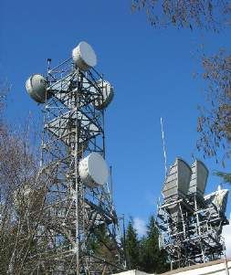
INTRODUCTION

change has the potential to affect and exacerbate multiple hazards and should be
incorporated into all emergency planning as relevant information becomes available.
Aircraft Accident
One or more aircraft either striking the ground, another aircraft or a structure, causing injury,
fatalities, destruction of property and/or forest fire.
 Animal Disease
Three types: non-infectious, infectious, and parasitic diseases with the potential to spread
between animals and potential spread to humans.
Avalanche
Gravitational movement of snow and ice down a sloped surface that commonly results from
dense, wet snow falling on dry, loosely packed snow. Ambient temperature and wind
conditions are also critical factors.
Dam Failure
A crack or total breach in a dam resulting in excess water on the down-stream side of the
dam. The amount of water flow and associated damage will depend on the size of the dam
and the extent of the break.
Dangerous Goods Transport
Solids, liquids or gases that can harm people, other living organisms, property or the
environment. The transport of these goods may cause explosions, spills or contamination.
Debris Avalanche and Debris Flow
High velocity flow of mud, rocks, brushes, trees, and other debris propelled by torrential
rains.
Drought
Abnormal shortage of water, typically occurring throughout the summer months over an
extended period. Drought can cause crop failure, depletion of municipal water sources,
increase in forest fire risk and insufficient water flow through waterways.
Earthquake
Violent shaking of the earth’s surface accompanying movement along a fault rupture.
Seismic energy traveling in waves may cause damage to structures, generate tsunamis,
trigger landslides, liquefaction or other geologic events. There are three types of damaging
seismic categories which could affect British Columbia:
Crustal Earthquakes: typically, low magnitude ground movement occurring along faults at an
average depth of 10 – 20 km.
Sub-crustal Earthquakes: Occur at a depth of 30 – 70 km are produced by fracturing and
frictional slipping of preexisting faults along a tectonic plate.
Subduction Earthquakes: The most powerful type of earthquake, these occur when there is
a massive shift at the junction of multiple tectonic plates.
Epidemic and Pandemic
A pandemic refers to an epidemic that spans a large geographic area and can often become
a global situation. An epidemic is a situation where a disease affects many people in a given
area, resulting in illness and potential death.
Erosion and Sedimentation
Erosion is the weathering away of land through the action of natural forces and increases the
risk of slope failure. Sedimentation is the buildup of land by natural or artificial means,
increasing the likelihood of flooding.
Explosion and Gas Leak

                                                                                                    6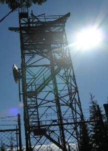
INTRODUCTION

An explosion is the ignition of a flammable substance resulting in instantaneous combustion.
A gas leak can be caused ruptured pipelines or faulty valves and can potentially result in an
explosion.
Extreme Weather Event
Unexpected, unusual, unpredictable or unseasonal severe weather, which may include
blizzards, ice storms, lightening or snowstorms.
Blizzard: Combines low temperatures, blowing snow and wind with speeds ranging from 90
to 130 km/hour. Conditions are most severe in open or deforested areas where there are no
trees or structure to act as wind breakers
Ice Storm: A combination of high wind, rain, and freezing temperature creates freezing rain,
which adheres to roads, buildings trees, power lines and electrical towers causing structures
to collapse.
Lightning: Ascending moisture laden unstable air leads to the formation of thunderclouds
which transmit electrical charges of up to 100 million volts of electricity from cloud to cloud
or ground.
Snowstorm: The accumulation of several centimeters to meters of snow that covers roads
and infrastructure.
Flooding
Local flooding is an increase in water level associated with an extreme hydrological event,
such as record rainfall or poor / blocked drainage. Whereas, freshet flooding is an overall
increase in water level due to late spring event caused by the melting of snow pack.
Hail Storm
Precipitation in the form of ice balls of five millimeters of more in diameter. These ice
pieces are formed in the upper atmosphere when updrafts carry raindrops from storm
clouds into colder areas.
Hazardous Materials Accident – In-situ
Uncontrolled release of an explosive, flammable, poisonous, corrosive, reactive, or
radioactive substance on site or during transport that poses a risk to health, safety, and
property. Spills are classified in British Columbia as urgent (Code II) or Non-Urgent (Code I).
Code II Spills pose a threat that may require evacuation.
Heat Wave
Significant rise in ambient temperature above the mean for an extended period of time, or
by a combination of high humidity and lack of air motion.
Landslide
Down slope movement of soil, rock, and organic materials as a result of gravity.
Land Subsidence
Land subsidence occurs when a surface has been undermined and deformation and ground
movement occur, which may be caused by declining groundwater levels, aquifer system
compaction, drainage of organic soils, underground mining, hydrocompaction, natural
compaction and sinkholes.
Marine Accidents
Accidents that include collisions, groundings, strikings, explosions and fires, structural
failures, accidental spills of petroleum products or chemicals, loss of cargo and human
death or injury.
Plant Disease & Pest Infestation
Plant disease refers to pathogens such as viruses, bacteria and fungi that affect the health of
plants. Pest infestation refers to foliage or root feeding insects that damage plant life.

                                                                                                  7
INTRODUCTION
Power Outage
The extended loss of electricity delivery to homes and businesses.
Riot
A violent outbreak involving many individuals with either a common or random intent to
destroy property, assault persons or otherwise disturb the peace. Commonly, riots originate
from union picket lines, strikes or protests.
Rockfall
One or more rocks fall freely from a cliff edge or rock face.
Structural Collapse
When a building or structure collapses due to engineering or construction problems, metal
fatigue, changes to the load bearing capacity of the structure, human operating error or any
other cause such as earthquake, flood, fire, explosion, and snow or ice buildup.
Structure Fire
A fire that compromises homes, offices, factories and other structures.
Tsunami
A tsunami is a large-amplitude, low frequency wave, usually generated by a seismic event
that originates in the ocean, displacing the water above it. Three categories of tsunamis
threaten British Columbia: telegenic, local marine, and local terrestrial.
Telegenic tsunamis are remote-source; in the Bowen Island Municipality, this refers to
tsunamis generated at numerous locations generated along the subduction zones of the
Pacific Rim. Local marine tsunamis are caused by terrestrial and submarine landslides.
Water Contamination
Water contamination refers to bother dangerous bacteria found in drinking water as well as
intentional contamination of the water supply. These events have the potential to cause
serious health effects or illness.
Wildland Fire
Uncontrolled burning in a relatively unpopulated grassland, brush, or woodlands.
Wildland Urban Interface Fire (WUI)
Fires that have encroached on a developed and populated area.
8BIM OVERVIEW
Bowen Island Municipality Overview
Bowen Island is located in Howe Sound, 6 kilometres west of mainland BC and accessed by
a 20-minute ferry ride that departs from BC Ferries Horseshoe Bay Terminal in West
Vancouver. There are also multiple foot-passenger only water taxis that depart from
Horseshoe Bay and downtown Vancouver to bring residents and visitors to Bowen Island.
The island itself is approximately 6 kilometres wide by 12 kilometres long, with a land area of
just under 50 square km.
Bowen Island has a permanent population of approximately 3,680 residents, 4 which has
grown 8.2% over 5 years, 5 and is a member of both the Islands Trust and Metro Vancouver.
The island experiences population surges during the summer months due to the arrival of
more than 1500 part-time residents and thousands of short-term and day-visitors. The
demographics and economy of Bowen Island are further discussed in the next section.
4
Statistics Canada, Census Profile 2016, Bowen Island Municipality.
5
Statistics Canada, Census Profile 2016, Bowen Island Municipality.
9VULNERABILITY
Section 2: Vulnerability
Vulnerability is defined as people, property, infrastructure, industry and resources or
environments that are particularly exposed to adverse impact from an emergency or
disaster. This HRVA discusses four types of vulnerability: social, economic, environmental
and physical.
Social Vulnerability
Hazards such as wildland urban interface (WUI) fires, earthquakes, floods and human health
emergencies can have particularly serious impacts on vulnerable populations such as the
elderly and the young. In this assessment, social vulnerabilities reflect the degree to which
societies or socio-economic groups are affected by stresses and hazards that negatively
impact the social cohesion of the municipality. For the purposes of this HRVA, social
vulnerability is the ability of an individual within a household to recover from a hazard’s
impacts. This HRVA analyzes 3 potentially vulnerable groups based on age, language and
residency.
Language Groups
According to Statistics Canada, less than 1% of Bowen Island residents regularly use a
language other than English as a language first learned and still understood: the same is true
for languages used most often at work. 6 Language barrier challenges, therefore, are not likely
to be a significant problem during times of an emergency.
Age Groups
At the time of the last census, approximately 17% of the Bowen Island population was 14
years of age or younger; 7 which is higher than the provincial average of 14%, and the national
average of 16%. 8 Special considerations for these young individuals are relevant, particularly
if they are separated from their parent or guardian: as such, the number of students
expected to be at school on a given day are indicated below. Schools and childcare
facilities on Bowen Island include:
• Bowen Island Community School, 1041 Mount Gardner Rd. approx. 335 students 9
• Island Pacific School, 671 Carter Rd, approx. 65 students 10
• Island Discovery Learning Community, 889 Cowan Point Drive, 10-30 students,
depending on the day11
• Bowen Children’s Centre, 650 Carter Rd, up to 40 students and 20 drop- in families 12
• Bowen Island Montessori School, 587B Artisan Lane, 8-16 students 13
6
Statistics Canada, Census Profile 2012, Bowen Island Municipality.
7
Statistics Canada, Census Profile 2016, Bowen Island Municipality.
8
Statistics Canada, 2016.
9
Personal Communication, Jan 10, 2017, Scott Slater, Principle, Bowen Island Community School.
10
Island Pacific School. About Us. http://islandpacific.org/about-island-pacific-school/
11
Personal Communication, Aug 21, 2017, Allan Saugstad, Program Director, Island Discovery Learning Community.
12
Personal Communication, Nov 30, 2017, Sarah Winny, Bowen Children’s Centre.
13
Personal Communication, Jan 14, 2018, Helen Davenport, Bowen Island Montessori School.
10VULNERABILITY
The 2016 census also indicates that approximately 21% of residents are over the age of 65,
which is higher than the provincial average of 18%, 14 as well as the national average of 17%. 15
These statistics are relevant in times of emergency, as the elderly may face more challenges,
have greater needs, and require specialized attention. Specific challenges include
transporting older adults who use assistive devices, providing appropriate health services
and nutrition, meeting the needs of people with limiting conditions (such as hearing issues or
dementia), and respecting the emotional state of senior individuals who may experience
transfer trauma associated with sudden and unexpected relocation. A higher concentration
of seniors is present at Bowen Court, a seniors housing cooperative at 1070 Miller Rd; a new
seniors residence (Snug Cove House) is also currently under construction immediately
northwest of Bowen Court.
Non-Residents
Bowen’s scenic beauty, outdoor recreation opportunities and proximity to Vancouver make
it an attractive tourist destination. Tourists may not speak the language, be familiar with the
island, or know where to go for information in the event of an emergency. In the summer
particularly, there are likely to be a large number of tourists on the island, especially on
weekends. Gathering places and centres such as Rivendell Retreat, Orchard Recovery, local
marinas, the Snug Cove area and Artisan Square are likely to have higher concentrations of
non-residents.
It is worth noting that Bowen is used as a thoroughfare by an unknown but presumably small
number of individuals moving to other areas of Howe Sound. There are Pasley Islands
residents and property owners that use Bowen Island to get to and from the mainland; these
individuals use Bowen Bay to park their vehicles and travel from. Others come via boat to
work on Bowen from Gambier Island and the Sunshine Coast. These individuals may have
unique needs and interests in the event on an emergency that affects Bowen Island.
Economic Vulnerability
Disaster literature indicates that the loss of a major industry or employer as the result of an
emergency can lead to a reduced population, increase in foreclosed homes, and reduced
tax revenue in the affected community. Loss of property tax base associated with damaged
and destroyed housing and commercial real estate can have a longer-term impact on
operating budgets. Closure or relocation of major employers – and the loss of jobs with that
employer and with related/dependent businesses - directly affects the confidence of a
community to rebuild. 16
BC stats indicates that approximately 1342 people are employed on Bowen Island, and that
the majority of businesses on island are small with 1-4 employees, and only 3 island
businesses have over 50 employees. Many residents commute daily from the Island to other
areas of Metro Vancouver for work. Economy and employment within the Municipality are
dominated by home construction, tourism and local services, with construction employing
the largest share of the workforce; the value of the construction industry in 2014 was over 15
14
Statistics Canada, Census Profile 2016, British Columbia.
15
Statistics Canada, 2016.
16
Wemple, C. 2008. Challenges of Economic Recovery Following Natural Disasters – Insights Gleaned from
Hurricane Ike. Risk Institute.
11VULNERABILITY
million dollars. 17 Tourism is also a major economic driver on Bowen Island; there were 21,800
overnight stays in 2013. 18 There are multiple restaurants and accommodation providers,
ranging from single room bed and breakfasts to multi-unit commercial rental operations.
Environmental Vulnerability
Much of the local tourism industry is driven by the attraction to Bowen Island’s natural
surroundings; the island has municipal and regional parks and trails, crown land and
numerous wetlands within its boundaries, all of which are areas important to biodiversity
and of ecological value. The shoreline is also a sensitive area, susceptible to degradation as
a result of rising sea levels, as well as off shore hydrocarbon spills. Local water reservoirs are
also vulnerable to contamination, intentional or otherwise - these include:
• Josephine Lake (Cowan Point Utility)
• Honeymoon Lake (BIM)
• Grafton Lake (BIM)
• Eagle Cliff Reservoir (BIM)
Physical Vulnerability
Within this HRVA, critical facilities are defined as facilities that are essential to the
Municipality to carry out emergency response activities. However, it is important to note
that there are numerous critical facilities external to the Municipality that are essential in
order for outside agencies to support the Municipality in an emergency (e.g. Vancouver
BCAS dispatch, the EMBC Emergency Coordination Centre [PECC] in Victoria, the Joint
Rescue Coordination Centre [JRCC] in Victoria). The following is an analysis of critical
facilities and infrastructure on Bowen Island.
Critical Response and Recovery Facilities
The primary critical facility for coordination of a large-scale disaster or (non-routine)
emergency is the Municipality’s Emergency Operations Centre (EOC). Please see Section 4,
for more information regarding Bowen Island’s EOC setup. Before, during, and after an event,
the EOC is essential for site support, including the coordination of special resources,
information, multiple departments and external agencies. In addition to the EOC, emergency
first response facilities that are of critical importance to carrying out emergency response
activities include police, fire, ambulance, ESS reception centres, and other facilities. On
Bowen Island, these include:
Fire Hall #1 788 Grafton Rd
Fire Hall #2 (Primary EOC) 1421 Adams Rd
RCMP Station 1017 Miller Rd
BC Ambulance Station #225 1034 Miller Rd
Municipal Hall (Secondary EOC) 981 Artisan Lane
Public Works Yard #1 1060 Mount Gardner Rd
Public Works Yard #2 Athletic Park Rd
17
Bowen Island Municipality, Community Profile, 2016. http://www.bowenislandmunicipality.ca/community-
profile
18
Ibid
12VULNERABILITY
Response capabilities are discussed further in Section 3.
Critical Infrastructure
Critical infrastructure consists of those physical and information technology facilities,
networks, services and assets which, if disrupted or destroyed, would have a serious impact
on the health, safety, security or economic well-being of the Bowen Island Municipality or
the effective functioning of the government. According to Public Safety Canada, critical
infrastructure spans ten sectors: 19
1. Energy and Utilities (e.g. electrical power, natural gas, oil production and
transmission systems)
2. Communications and Information Technology (e.g. telecommunications,
broadcasting systems, software, hardware and networks including the Internet)
3. Finance (e.g. banking, securities and investment)
4. Health Care (e.g. hospitals, health care and blood supply facilities, laboratories and
pharmaceuticals)
5. Food (e.g. safety, distribution, agriculture and food industry)
6. Water (e.g. drinking water and wastewater management)
7. Transportation (e.g. air, rail, marine and surface)
8. Safety (e.g. chemical, biological, radiological and nuclear safety, hazardous materials,
search and rescue, emergency services, and dams)
9. Government (e.g. services, facilities, information networks, assets and key national
sites and monuments)
10. Manufacturing (e.g. furniture, glass, truck canopies)
With the exception of manufacturing, all sectors are expanded upon below.
Energy
Energy (electrical power) and fuel (diesel, gasoline, propane) are essential to day-to-day
operations within the Bowen Island Municipality to heat homes and businesses, cook and
preserve food, communicate through email, charge cellular phones, bathe and flush toilets,
and fuel equipment and vehicles. Without electrical power, fuel is required to maintain
many of the services that the municipality relies upon. The underwater BC Hydro supply
meets land on the east side of the Bowen Island at September Morn Beach (south of Dorman
Bay), and on-island infrastructure consists of overhead and underground distribution lines.
Access to fuels, both gasoline and diesel, is considered essential in day-to-day and post-
emergency situations. Fuel is vital for emergency response and heavy equipment vehicles,
generators, and for members of the community needing to fuel personal vehicles. As a
result, fuel is expected to be in high demand post-emergency; diesel in particular will be
required to operate most heavy-duty machinery. There are two large fuel distribution and
storage facilities on Bowen Island. These include:
Gasoline and Diesel Storage, Pubic Works Yard, 1060 Mount Gardner Rd
Gasoline and Diesel Storage, Bowen Fuels Station, 1062 Mount Gardner Rd
19
Public Safety Canada. 2014. Action Plan for Critical Infrastructure (2014-2017).
13VULNERABILITY
It is necessary to note that if the ferry service is suspended or unavailable for any reason
post-disaster and the single fuel supply route is disrupted, there is a limited amount of fuel
available on Bowen Island. The possibility of bringing additional fuel to the municipality via
barge (into Snug Cove) exists, if fuel is readily available on the mainland, and a fuel truck for
transport can be secured. Of note, because both stored fuel locations on Bowen Island are
neighbouring, any emergency affecting or isolating that area of the island could exacerbate
the issue. Bowen Fuels, the only public-access fuel station, carries 5 different types of fuel:
Type Tank Capacity
Regular Gasoline 20,000 Litres
Premium Gasoline 7,000 Litres
Marked Gasoline 7,000 Litres
Regular Diesel 7,000 Litres
Marked Diesel 7,000 Litres
Bowen Fuels has at most 27,000 litres of unmarked gasoline at any given time, though in the
summer months they are likely to have far less, and occasionally run out of gasoline due to
high demand, despite once-per-week fuel delivery (Wednesdays). The fuel station does not
have the ability to pump fuel without power; in the event of a power outage, they hope to
borrow a generator to continue to operate. In the past, Bowen Fuels have borrowed a
municipal generator during power outages.
The Municipal Public Works Yard has two fuel storage tanks, one gasoline and the other
diesel, both of which have a 4,500 litre capacity. How often these tanks are refilled varies
seasonally, but averages once monthly, with more deliveries taking place in winter months
than during summer.
Privately owned Twin Island Excavating also stores diesel fuel at their quarry on Radar Hill,
and have up to 9000 litres of diesel fuel stored at any given time. 20 Privately owned Bowen
Building Centre stores propane: the 16,000-litre tank at 1013 Grafton Rd is filled to 100% in
November, and at other times of year is on average is approximately 50% full. This propane,
however, cannot be accessed during a power outage.
Communications
Television and radio broadcasting, as well as cellular and land line telephones, are
considered essential in emergency operations. Communications infrastructure is essential
for the Emergency Operations Centre, broadcasting systems, and front-line responders in
communities in the aftermath of a disaster. Communication is necessary for: assessing
damage and need; collecting information on supplies and other resources; coordinating
rescue and relief activities; accounting for missing people; and motivating public, political,
and institutional responses. It is important that communication infrastructure in a hazard
prone area be resilient with built-in redundancy.
North Shore Emergency Management and British Columbia Ambulance Service use
repeaters on Mount Gardner. The Bowen Island Fire Department, BC Hydro and the Coast
20
Personal Communication, Sept 5, 2017, Randy Arnott, Owner, Twin Island Excavating Ltd.
14VULNERABILITY
Guard have facilities on Radar Hill. The Metro Vancouver Inter Municipal Emergency Radio
System (IMERS) has a UHF repeater on Mount Gardner (Channel 2C); given that (due to
topography) this is the only link from the Provincial Regional Emergency Operations Centre
(PREOC) to the Sunshine Coast Regional District, Squamish-Lillooet Regional District, Bowen
Island, Squamish and Lions Bay Emergency Operations Centres, this repeater is a vital part of
the communications back-up system.
Telus is responsible for the provision of telecommunications service to the Bowen Island
Municipality. Cellular towers are generally equipped with back-up power that will last 4-8
hours depending on usage. The Canadian Radio-television and Telecommunications
Commission (CRTC) noted that in 2016, more Canadian households had mobile phones than
landlines, more Canadian households subscribe solely to cellular than landlines, and that
subscriptions to wireless continue to increase year over year while landlines decrease. 21
This information will be relevant with regard to public communications if cellular
communication is not available.
Telecommunications and repeater towers atop Mt. Gardner on Bowen Island
Despite built-in redundancy, cellular phone failure in emergencies is not uncommon; most
often these failures are caused by the extraordinary demands placed on cellular networks.
Even if communication infrastructure is not damaged, the emergency provokes greater
communication by the public, the result of which is often a denial of service for all, including
emergency personnel. 22 Telus will strive to keep its equipment operational with primary
emphasis on vital communications infrastructure needed by the Municipality to respond
effectively to a major emergency. In addition, there is a satellite phone at the EOC, public
works has one and the Emergency Social Services Director has a personal satellite phone.
Both Shaw and Telus provide internet service to the island, with the Municipality relying on
Shaw for internet provision at its offices and facilities. Shaw has staff and vehicles on Bowen
Island, and prioritizes Snug Cove and Artisan Square for service restoration in an island-wide
21
Canadian Radio-television and Telecommunications Commission. 2016. 2.0 Canada’s Communication System:
An Overview for Canadians.
22
National Research Council. 2002. Making the nation safer: the role of science and technology in countering
terrorism. NY, United States of America: Committee on Science and Technology for Countering Terrorism.
15VULNERABILITY
outage. Shaw’s generators rely on propane during a power outage. Amateur radio services
are also available and are discussed in Section 4.
Finance
There is only one financial institution on Bowen Island: First Credit Union, located at 106-996,
Dorman Rd. The Bowen Island branch of First Credit Union serves approximately 1800
members, and engages in business continuity and disaster recovery planning. 23 There is also
an automated teller machine (ATM) operated by Blue Shore Financial, located at 105-475
Bowen Island Trunk Rd.
Health Care
The Vancouver Coastal Health Authority provides services to the Bowen Island
Municipality. Bowen Island is included in Local Health Area #45 (West Vancouver-Bowen
Island), within North Shore/ Coast Garibaldi Health Service Area #33. There is no urgent care
clinic on island, however there are two private physician practices; one at 203-566 Artisan
Lane (Dr. Susanne Schloegl) open 4 days weekly, and one at 101-495 Bowen Island Trunk Rd
(Dr. Utah Zandy) open 1-2 days weekly. The BC Ambulance Community Paramedicine
program was introduced on Bowen in late 2017. This initiative will see 2 paramedics working
2 days per week on Bowen Island, with an aim to bridge health service delivery gaps in
collaboration with local primary care teams.
The Caring Circle Health Resource Centre is a Bowen Island based, non-profit organization
that provides health navigation services, delivers community programs, and maintains a
comprehensive list of Bowen’s extended health professionals in their Health Resource
Guide.
Pharmaceutical supplies are essential to the treatment of chronic medical conditions, acute
injuries, environmental exposures, and infectious diseases during emergencies. In post-
emergency situations, high demand is placed on pharmaceutical supplies. Medicines are
needed for the treatment of injuries and diseases as a result of emergencies, as well as
medicines for chronic illness that are often worsened by post-emergency conditions. 24
Bowen Island has one pharmacy, Cates Pharmacy, which is open 6 days per week and
located at 203-495 Bowen Island Trunk Rd.
Food
Emergencies can disrupt food supply and delivery resulting in food shortages. Groceries can
be purchased on island at the Snug Cove General Store and the Ruddy Potato Whole Foods
Market, and prepared food can be purchased at one of many island restaurants. The General
Store grocery food supply is roughly 2-4 days for perishables, and 1-2 weeks for non-
perishables, under normal consumption. 25 There are also several small farms that produce
seasonal goods on island, and these farms, combined with the restaurants (approximately 8),
could potentially increase the amount of available food. Emergency rationing could also
make the limited supply last longer. Due to the isolated nature of the Municipality, any
disruption in ferry service could quickly lead to food shortages.
23
Personal Communication, Aug 16, 2017, Kevin Manning, Manager (Bowen Island), First Credit Union.
24
Jhung, M. 2007. Chronic Disease and Disasters Medication Demands of Hurricane Katrina Evacuees. American
Journal of Preventative Medicine. 33(3): 207-10.
25
Personal Communication, Snug Cove General Store, Aug 21, 2017.
16VULNERABILITY
Water
Safe and accessible water for drinking and sanitation is imperative to the health and well-
being of the residents and visitors within the Bowen Island Municipality. According to Public
Safety Canada, approximately 206,080 litres of water is needed to sustain Bowen Island’s
population of 3680 for 14 days. 26 This amounts to four litres per person per day for the two-
week duration. The Municipality’s current water supply consists of both municipal and
private water sources.
Municipal Water
The Municipality is responsible for provision of water to approximately 1500 properties; of
these, approximately 1100 are active users. Census data from 2016 indicates that there are
1915 private dwellings on the island; the municipality thus provides water for approximately
57% of Bowen’s households. 27
The municipality operates 7 water systems across the island, and has enough backup
generators to ensure that all systems can be maintained without hydro, if diesel fuel is
available. The Municipality can continue to provide water to all homes on the municipal
system in the event of a power outage, assuming there is no damage to infrastructure and
that municipal staff are available, for as long as fuel is available. In the event of disruption to
multiple systems, restoration of water supply is likely to be prioritized based on the number
of users on the system.
Water System Approx. number of active users
King Edward Bay 19
Bowen Bay 60
Hood Point 89
Eagle Cliff 98
Tunstall Bay 128
Bluewater Park 142
Cove Bay (includes Valhalla and Cates Hill) 630
Non-Municipal Water
There are approximately 11 non-municipal water systems; 28 it is unknown how many total
users are on these systems. The largest non-municipal water system is Cowan Point Utility,
which has approximately 89 connections. 29 There are backup diesel generators on site at
both the pump-house and the treatment plant for this system, and thus users could continue
to access treated water in the event of a power outage. As well, this pump could
theoretically pump untreated water directly from the local lake in the event of infrastructure
damage to the water system. Most of the remaining homes on Bowen are serviced by
individual wells or groundwater supplies. The island has 7 distinct aquifers, the majority of
which (5) are deep fissure.
26
Canada Department of Public Safety and Emergency Preparedness. 2015. Frequently Asked Questions.
https://www.getprepared.gc.ca/cnt/rsrcs/faq-en.aspx#a02
27
Statistics Canada, Census Profile 2016, Bowen Island Municipality.
28
Wiltshire House Publishing. 2017. Bowen Phone Book, page 7.
29
Personal Communication, June 15, 2017, Larry Adams, Cowan Point Utility.
17VULNERABILITY
Transportation
During and after an emergency or disaster, transportation is an essential component of
effective emergency response and recovery. Bowen Island is accessible via water and air
transport. Due to the dependency of the community on the water and water-based
transportation, climate change, including rising sea level, poses a threat to critical
community infrastructure and should be monitored and accounted for in planning.
BC Ferries operates 14 daily roundtrip sailings between the Horseshoe Bay and Snug Cove
terminals, with a one-way trip lasting 20 minutes. Water taxis (for passengers) and barge
service (for freight, fuel and supplies) are available locally, both on Bowen Island and
throughout Howe Sound. The municipality maintains 2 public boat docks on Bowen Island,
one at Mount Gardner and one in Snug Cove; there are also many private docks around the
island. Numerous access locations for water taxi service exist both on the island and the
mainland. Small barges are typically brought into the Snug Cove boat ramp, which is
operated by the Union Steamship Company Marina, though there are also two unmaintained
boat launches, one at Sandy Beach (just north of Snug Cove), and one at Tunstall Bay (West
side of island) that could potentially be utilized as barge landing sites in an emergency.
Air transport is via helicopter (weather dependant) or floatplane (seasonal). Float plane
travel, both private and chartered, is available from Vancouver to Snug Cove on a regular
basis during summer months. Bowen Island has no Transport Canada approved helipads,
however numerous helipads and helicopter landing sites exist across the island, including
the Coast Guard helipad and rock quarry on Radar Hill, which has been used in the past by
the RCMP. BC Ambulance helicopters will not land on Bowen at night, however during the
day these helicopters may land at either the golf course and at the Snug Cove Picnic Area in
Crippen Park (the “Bowfest Field”).
The Municipal Public Works department is responsible for the operation, maintenance and
construction of the Municipality’s roads. Most of Bowen Island’s roads, with few exceptions,
are terminating, meaning sub-communities are not connected by more than one main
thoroughfare. The consequences of these sub-communities becoming isolated may include
difficulty receiving medical attention, inability to communicate for assistance, dependence
on stored supplies, and delays in fire response. Priority roads include Bowen Island Trunk,
Grafton, Adams, Miller, Eagle cliff, Bowen Bay. Only 3 bridges are part of the municipal road
network, located on Carter Rd, Arbutus Bay Lane and Cape Lane.
Public transportation options are limited within the municipality. First Transit is the service
provider for TransLink’s Community Shuttle buses on Bowen. They are reachable in the
event of an emergency on Bowen Island and will provide driver(s) as needed for emergency
transportation and/ or as a shelter coach as officially requested by the Bowen Island
Municipality. 30 There are also private transportation providers on island, including a taxi and
private bus company.
30
Personal Communication, May 23, 2017, Norm Fraser, Manager, Coast Mountain Bus Company.
18You can also read