Distressed Properties: Pathways of Decline and the Emergence of Public Safety Risk - Len Garis, Larry Thomas, and Alex Tyakoff
←
→
Page content transcription
If your browser does not render page correctly, please read the page content below
Distressed Properties: Pathways of Decline and the
            Emergence of Public Safety Risk

Len Garis, Larry Thomas, and Alex Tyakoff
May 2016
Executive Summary

The intent of this study is to develop an understanding of the forces and factors that trigger and
accelerate the decline of residential properties in the City of Surrey, British Columbia (BC), and to
create a framework for action that can stem such decline. Identifying residential properties
trending toward a distressed state is essential given the effects of declining neighbourhoods and
inherent risks to the community. There are numerous implications of declining properties and
neighbourhood distress which include heightened fire risk, crime and disorder, and by-law
violations at or near such places. This study selected distressed residential areas in Surrey for
intensive problem management and, crucially, areas that are undergoing shifts in land economics
and tenure. By identifying neighbourhoods and residential properties tipping toward a state of
distress, local government can take pre-emptive measures to avert the most adverse problems
before they occur.

Another issue relates to the desire to purchase land for development during favourable housing
market conditions. Investments can be undertaken by investors buying up smaller parcels on the
same block and eventually assembling them into a large land package for re-development. In some
cases, the land is purchased, but then it is up to the investor when they want to build. This means
they have little, if any, incentive to stop houses falling into decay. Disinvestments occur when
maintenance is deferred or completely withheld, resulting in an individual unit that is vacant or an
increase in abandoned residential properties that are vulnerable to intrusion, theft, vandalism, fire
risk or arson. Some distressed properties have been re-purposed into drug recovery group homes,
rooming houses or similar uses and vulnerable people will gravitate to such places wherever they
exist. Residential custodianship at these properties is low or absent. Other properties will fall victim
to criminal activity or disorder. Speculative land practice and disinvestment in housing are
pathways to neighbourhood distress and the emergence of public safety risk.

Perhaps the most important lesson from the study is the difficulty of pinpointing a specific trigger
that initiates residential distress and neighbourhood decline. Indeed, neighbourhood decline does
not have a readily identifiable starting point or single isolated cause. Rather, decline is triggered by
a set of circumstances that is specific to particular cities. Once underway, decline and disinvestment
tend to be evolutionary and accretive. In essence, neighbourhood decline is a complex, self-
reinforcing phenomena in which symptoms of decline themselves become causes.

                                                                                                           3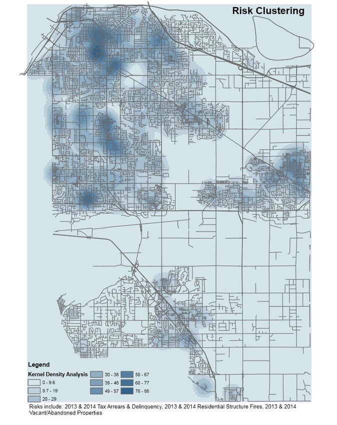
KEY FINDINGS
The study is conceptualized and framed in terms of stages of neighbourhood decline.
Neighbourhoods are shaped, to a large extent, by local and regional economic drivers and
demographic shifts in the resident population. They typically evolve through phases of
growth, stability and decline, and stressed residential areas often undergo five stages of
decline. They are: (1) incipient decline; (2) imminent decline; (3) clearly declining; (4)
accelerating decline; and (5) abandonment. The stages of neighbourhood decline are not
linear nor necessarily terminal, they can be managed, halted or reversed depending on the
ability of residents and responsible tiers of government to act. However, the ability to pre-
empt or otherwise halt the trajectory and velocity of a declining neighbourhood is made
increasingly difficult at the more advanced stages of decline. It is imperative to focus on the
full life-cycle of places, and interrupt the cycle of decline at the onset, not just focus on
abandonment, which is the last stage in the decline cycle.
In 2014 there were 12,646 residential properties in Surrey that were classified as older,
pre-1980s housing stock built on high value land. Overall, their land value is higher than the
value of the structure and, therefore, is subject to development pressures. Spatially, there is
clustering of such properties north and west of Surrey City Centre and in Newton. They are
located at or near areas with a higher density of crime and fire risk, and suffer from low
levels of residential guardianship. These areas are well-known to local authorities and first
responders as chronic hotspots that consume a disproportionate share of resources
compared to other areas in Surrey. However, this study also points to emerging areas of
residential distress when looking at land economics, that is, Cloverdale and South Surrey,
communities that are undergoing development pressures. In settings where the value of a
lot far exceeds the value of a building, the property may tip into disinvestment and decline
or be purchased on speculation by investors with a view to developing the property and
adjacent properties. Depending on the housing market and timetable of investment, these
residential properties can sit vacant for a lengthy period of time and are susceptible to fire,
crime, and disorder.
A proxy of incipient decline is property tax arrears and property tax delinquency, objective
indicators of neglect and pathways to neighbourhood distress. Unlike vacancy, property tax
arrears do not have definitive indicators visible on the street. However, they represent
important economic markers of neighbourhood distress which are rarely considered in
neighbourhood distress studies. Spatial analysis was conducted on abandoned residential
properties, residential structure fires, and tax delinquent residential properties in Surrey.
What is notably different from existing hotspots is risk clustering in the Cloverdale area of
Surrey. Risk densities in the Cloverdale area are comparable to those existing in the area
north and west of Surrey City Centre and in Newton. Spatial analyses of abandoned
properties, residential structure fires, and property tax arrears points to an entirely new
area of public safety risk in Surrey.
4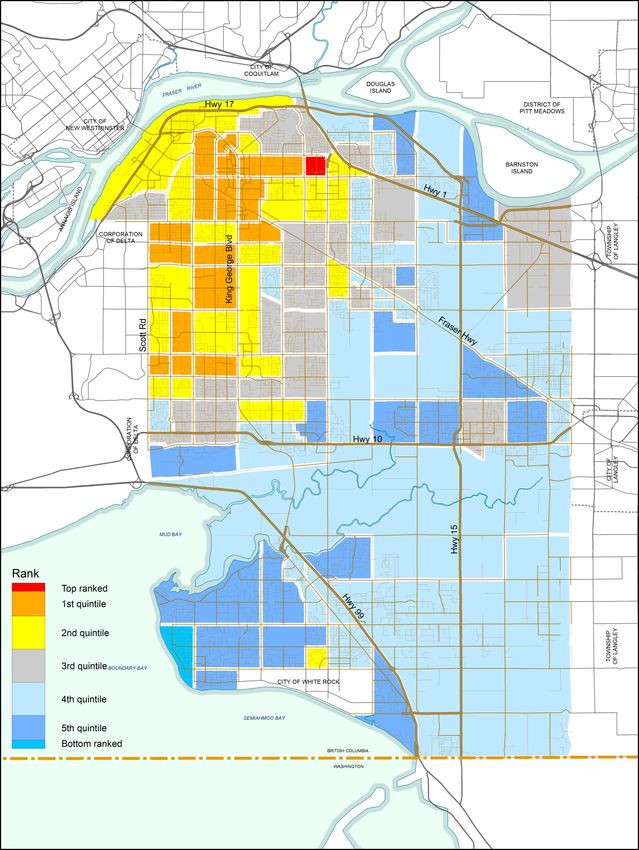
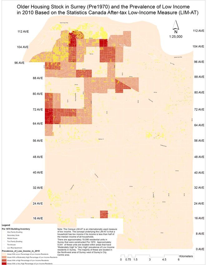
The Census Low Income Measure after Tax (LIM-AT) is an internationally used measure of
low income. The concept underlying LIM-AT is that a household has low income if its
income is less than half of the median income of all households. There are approximately
19,086 residential units in Surrey that were constructed pre-1970 according to the 2015
Surrey Building Inventory. Approximately 9,041 of these units are located within areas that
have ‘moderately high’ to ‘very high’ number of low income residents in Surrey. The LIM-AT
insert map reveals clustering in the area north and west of Surrey City Centre and cluster in
space with other risk measures such as fire, crime, and disorder.
A Neighbourhood Vulnerability Index (NVI) revealed concentrations of distressed areas in
Surrey. A comparison of the NVI map with LIM-AT spatial clustering shows overlap: the
tract bounded by 112th Avenue to the north, 96th Avenue to the south, and bordered by 132
Street to the west and 140 Street to the east. These stress maps identify hotspots where fire,
police, and emergency medical calls-for-service intersect. However, when building values
and lot values are considered along with property tax arrearage, parts of Cloverdale and
South Surrey are apparently entering imminent decline. In addition to addressing chronic
hotspots, namely, the area north and west of Surrey City Centre and Newton, the study also
considered long-range strategies to relieve emerging distress in Cloverdale and South
Surrey.
Introduction
SCOPE, NATURE, AND IMPACT OF DISTRESSED PROPERTIES AND PERSONS
Cities as places of human habitation have multiple and interwoven impacts on the built and natural
environment and upon their inhabitants. Many impacts are positive and contribute to liveability
and a better quality of life for residents, while others erode the fabric of life. Distressed cities,
neighbourhoods and their inhabitants suffer from a disproportionate share of social and economic
malaise relative to healthy and resilient cities and neighbourhoods, and vulnerable people tend to
consume a larger share of government services in distressed places. These range from social
housing and welfare programs and services to police, fire, by-law, and ambulance services.
Vulnerable people gravitate toward distressed neighbourhoods seeking affordable, subsidized, and
supportive housing and rental accommodation as well as access to transit, government, and
community-based services. They tend to avoid more affluent parts of a city as unwelcoming places,
while criminal sub-groups target these very areas and people in a predatory cycle. Many vulnerable
people fall victim to the push/pull effect of social dynamics in cities which can be polarizing and
stigmatizing for individuals, neighbourhoods, and communities (Gaffikin and Morrissey 2011). For
example, high-frequency service users struggle with mental health and addiction issues which often
lead to recurring medical or psychiatric crises, evictions, homelessness, criminal acts or incivilities.
In a 2015 Vancouver-based study, two cohorts of persons with complex co-occurring disorders
(concurrent mental illness, substance dependence, multiple convictions, hospitalizations, and
shelter assistance) consumed a substantial array of public services.
5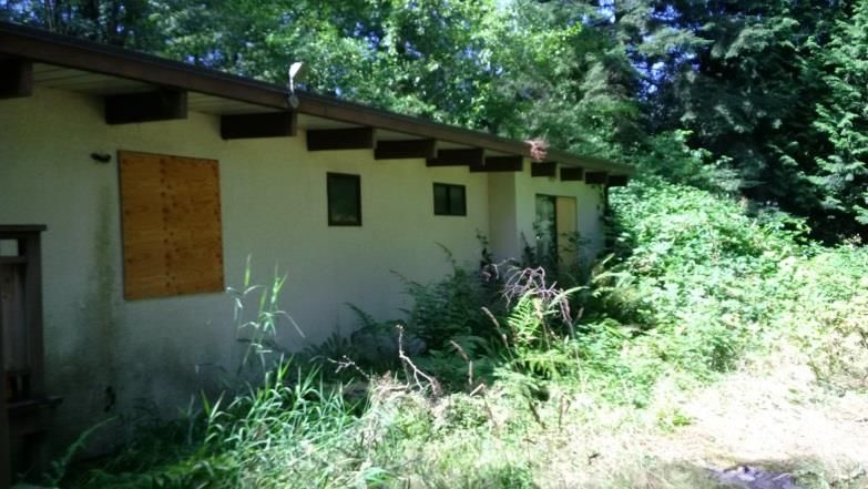
From more than 14,000 offenders sentenced in Vancouver’s Downtown Eastside, very high
    frequency service users associated with community (n=216) and custody (n=107) sentences
    incurred average attributable public service costs of $168,000 and $247,000 respectively over a 5-
    year period of observation. Health-related costs for both groups were over $80,000 per person,
    primarily associated with hospital admissions (Somers et. al. 2015, 1).

    Across both groups, 99 per cent had been diagnosed with at least one mental disorder and over 80
    per cent had co-occurring substance use and another mental disorder (Somers et. al. 2015, 1).
    Substance dependence fuels the rapid cycling through of public services with life-threatening
    implications for those who use illicit narcotics such as fentanyl. In 2015, there were 465 apparent
    illicit drug overdose deaths in BC with fentanyl detected in 30 per cent of them, an increase from
    the previous year (BC Ministry of Health, 2016).

    Regardless of their diagnoses, high-frequency service users cannot work which means that
    government benefits, property crime or panhandling becomes their primary revenue source. From
    the victim’s perspective, this is particularly costly. Addicts can spend anywhere from $70 to $1,000
    per day on their substance of choice. In order to support their drug habit, addicts will steal goods
    worth up to 10 times that amount (Plecas 2014, 12). The immediate and downstream costs to
    Canadian society and toll on persons with complex co-occurring disorders are staggering. Costs are
    also borne by distressed neighbourhoods where property crime, drug trafficking, and chronic
    substance use intersect. Drug trafficking operations at the street level drives neighbourhood
    distress in Canadian communities. Drug dealers continually seek out new clients who are, for the
    most part, high-frequency service users. Demand and supply drives this lucrative enterprise. It is
    estimated that drug dealers in BC may generate anywhere from $7,000 to $15,000 per day at the
    low end. A drug line shift worker on a high end established drug line in Surrey will see potentially 4
    clients per hour in a 12 hour shift, at minimum $300 per person. This equals $14,400 per 12 hour
    shift. The more established drug lines can generate anywhere from $14,000 to $28,000 per day.
    Drug traffickers operate 365 days a year, 24 hours a day (Bemister 2015).

    Research has demonstrated that burglaries and residential structure fires occur in the same places
    but at different times (Wuschke, Clare, and Garis 2013, 1-2). Areas with higher rates of
    unemployment, single parent headed families, and low-income households, as well as
    neighbourhoods with more vacant properties, older properties, and properties in need of repair,
    are associated with higher crime rates. Risks are elevated for households with at least one young
    child, seniors or person with a disability. In addition, rental units, households in low-income areas
    also experience elevated risk. Neighbourhood distress can take many forms and may, if left
    unchecked, cascade in a self-reinforcing process of decline that potentially leads to heightened
    public safety risk (Morckel 2013, 469; Han 2013, 316; Appel et. al., 2014, 161; Xiong, Bruck and Ball,
    2015).

    There exist concentrations of stressed and vulnerable people living or gathering at distressed
    places in the City of Surrey, and these individuals experience greater levels of risk and self-harm
    arising from the social, economic, medical, and legal upheaval in their lives. Social disorganization
    and civic disengagement may ensue which ultimately detracts from the underlying health and
    welfare of viable communities. A spread effect exists where social disorder and accompanying risk

6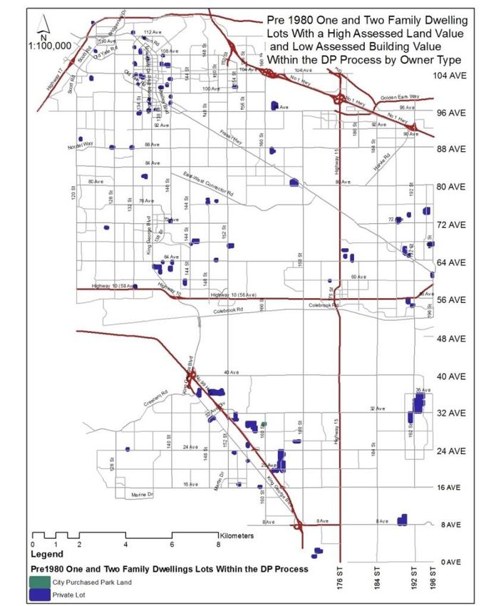
can potentially go beyond the range and limits of distressed neighbourhoods and erode healthy and
resilient communities. Local government is often left having to address a wide variety of seemingly
intractable and increasingly complex societal issues with existing city resources and limited
municipal authority to act. The consequences of this dynamic have far-reaching implications for the
community as a whole. Neighbourhood distress and social conflict may lead to heightened public
safety risk which is the catalyst for residential fires and medical emergencies, criminal activity and
disorder, all of which beset Canadian cities and neighbourhoods to some extent. Surrey is no
exception.

RATIONALE
In 2007, Surrey City Council implemented the Crime Reduction Strategy, an innovative problem-
solving approach to addressing the causes and effects of crime or put more broadly, neighbourhood
distress. Neighbourhood distress is defined as a situation reflecting concentrated social and
economic conditions which point toward lower quality of life standards for residents, and where
such conditions can present public safety hazards and raise service demands on local, provincial,
and federal government and community non-profit organizations (Jennings 2012, 465). Several
studies have recently addressed the issue of neighbourhood distress in Surrey. In 2014, BC
government unveiled their Report of the Blue Ribbon Panel on Crime Reduction which examined the
complex and multi-faceted aspects of crime and disorder in BC, and local initiatives such as those
existing in Surrey. In the same year, the Surrey Criminal Justice Task Force was formed and charged
with examining the unique justice needs and challenges in Surrey. It assessed a variety of public
safety issues such as domestic violence, mental health, and illicit substance use, as well as prolific
property offending, and considered promising local initiatives. Related efforts such as the Surrey
Integrated Services Network, an inter-agency provincial and municipal committee focussed on
enhancing justice and public safety service delivery in the City, represents yet another initiative in
dealing with neighbourhood distress. The topic of neighbourhoods in transition was addressed in
2016 by members of the City of Surrey’s Emerging Leaders Program (ELP), and was discussed at a
City-sponsored Innovation Forum on Distressed Properties and Public Safety.

These studies and local initiatives pointed to interconnected socio-economic, health, crime and
disorder issues in Surrey with a growing number of vulnerable segments of the population residing
at or gathering in distressed neighbourhoods or places within the City. With the presence of
distressed neighbourhoods or hotspots invariably come offenders and victims alike as well as
vulnerable persons some of whom engage in risky behaviours and lifestyles. These behaviours are
expressed in a variety of ways ranging from criminal or delinquent activity to reckless or negligent
acts that may lead to heightened public safety risk. The net effect of these acts and behaviours has
significant and enduring negative implications for the safety and welfare of the City and its
residents.

                                                                                                         7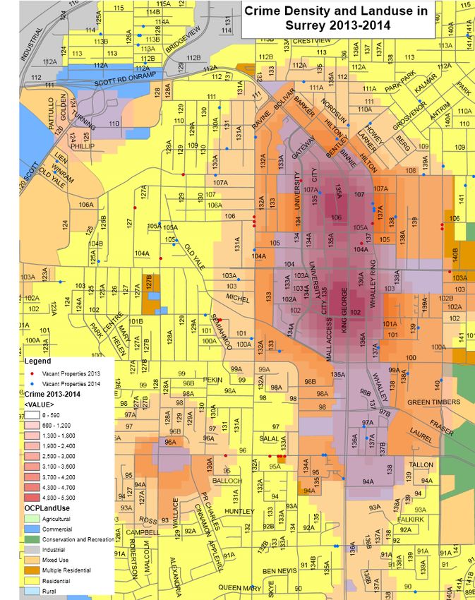
A challenge facing many BC municipalities is the identification and treatment of depressed
residential properties in distressed neighbourhoods and, crucially, residential properties on the
verge of decline. Properties at a tipping point are difficult to identify as they are not beset by
obvious signs of decline characteristic of derelict or unsightly properties, that is, broken windows,
graffiti, refuse, etc. Therefore, it is essential to understand when a residential property starts its
decline so that efforts can be focussed on pre-emptive problem-prevention measures. Successful
early intervention and treatment to minimize or potentially reverse the harmful spillover effects of
distressed residential properties is arguably the best course of action because deterioration
compounds quickly over time (Raleigh and Galster 2014; Morckel 2013, 470; and Gilreath 2013).
Three specific questions are posed and frame this study:
1. Is there a sequence of events that lead to distressed residential properties and neighbourhood
distress? If so, where in this continuum should local government act to effectively pre-empt
decline and address public safety risk?
2. Are property tax arrears and land value versus building value effective proxies of incipient
decline? If so, what long-term strategies can be developed to prevent the decline of properties
and neighbourhoods? How can evidence-based, data-driven solutions be leveraged for early
intervention?
3. How can the City integrate departmental data in order to identify those residential properties
or problem properties that require attention? What regulatory tools and strategies does the
City have in place to tackle these issues?
In order to answer these three questions, the scope of this research involved:
Undertaking a review and assessment of 12 datasets relating to neighbourhood distress
including land value metrics, a critical literature review of three distinct yet complimentary
academic and professional studies, as well as extensive consultation with law-enforcement and
fire experts. Field studies were also conducted.
INTENT OF STUDY
The aim of this study is to identify Surrey neighbourhoods and residential properties that are
declining or at-risk of decline and ensuing fire hazard and public safety risks. Recommendations are
made relating to the identification of vulnerable residential properties for treatment, problem
management, and evaluative purposes. The study employed a retrospective analysis of fire events,
and dealt primarily with intra-city analysis from the perspectives of the neighbourhood, building,
and household level. It is conceptualized in terms of risk to people and property and focusses on
vulnerable persons and problem properties. Ultimately, it is the residents or occupants of
distressed residential properties and nearby settings that are most at-risk for fire loss and injury.
8
The implications of non-compliance with the Fire Code are not trivial, and may result in tragedy if
left unaddressed. In 2010, a rooming house fire occurred at 2862 Pandora Street, Vancouver where
three individuals died. The house was designed as a single family dwelling, but its owner had rented
rooms to transients on a monthly basis. Conditions leading up to the fatal fire at Pandora Street are
similar to non-compliance issues and associated risks existing at many recovery houses in Surrey.
The Pandora Street rooming house was used in a manner that went beyond its intended design, that
is, to house a family.
The residence had frequently come to the attention of Vancouver City officials in ways similar to
how non-compliant recovery houses are identified in Surrey. That is, through fire safety inspections
or public complaints. The owner of the Vancouver rooming house was ordered to make
improvements to the property in order to bring it into compliance with the Fire Code, but did not
comply. Whether a rooming house or a recovery house, both facility types carry a similar level of
risk especially when they are non-compliant with the Fire Code, have a high occupancy load, and
lack effective fire safety devices. Occupants of these facilities are all vulnerable persons, the risk of
fire-related death or injury is equally present, and the owners/operators are often aware of the
problems but unconcerned about fixing them.
Study Area
The City of Surrey is part of the Vancouver Census Metropolitan Area, and is one of Canada’s largest
and most rapidly growing cities. Covering a total of 314.7 km2, the 2011 Canadian Census reports
that Surrey has a population of 468,251: an 18.6 per cent growth since the previous census period
(as compared to the national average growth rate of 5.9 per cent). The urban area is experiencing
rapid redevelopment, growth, and population expansion. Surrey is bordered on the north by the
Fraser River and on the south by the United States Canada international border, and is bounded on
the west by the Corporation of Delta and to the east by the Township of Langley. The City contains a
variety of land uses, ranging from high-density residential areas and commercial zones, through to
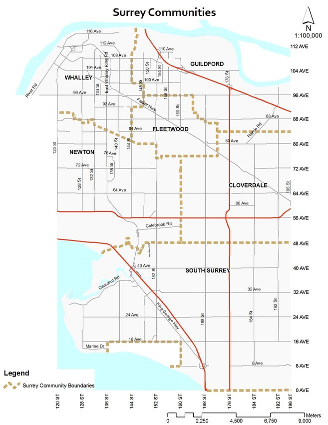
parks and farmland. Surrey is comprised of six distinct communities which are shown in Figure 1.
9FIGURE 1:
Source: City of Surrey Planning and Development Department
Surrey's population has grown significantly between 2004 and 2014 and continued growth is
expected for the foreseeable future. During these 10 years, the City's population has increased by
approximately 100,000 residents (Estimates are based on a combination of Surrey's Building
Permit Data and BC Assessment information). According to 2016 population estimates and
projections, the City can anticipate approximately 577,595 residents by the year 2021.
10Along with population growth comes challenges and opportunities in terms of meeting the needs of
all Surrey residents with municipal infrastructure, access to recreation and fitness, transportation,
police and fire services as well as green spaces to ensure a vital part of a livable, modern city. A
challenge related to such unprecedented growth and prosperity is addressing the reverse or
opposite side, that is, neighbourhood distress. This entails meeting the needs of vulnerable
segments of society and addressing public safety issues. Another challenge relates to the desire to
purchase land for re-development purposes. The land is bought, but then it is up to the developer
when they want to build. This means they have no incentive to stop it falling into decay. Vulnerable
persons will often gravitate to such problem properties wherever they exist in Surrey, thereby
increasing public safety hazards at or near these places. It is a perfect storm.
Precipitating Factors in Neighbourhood Distress: Literature Review
Measuring and mapping levels of neighbourhood social and economic distress can enhance our
understanding of the needs of vulnerable persons and communities and ensure their health and
safety. Importantly, it can facilitate civic engagement in the development of long-range strategies,
remedies, and place-based responses to address public safety risk. To that end, a multi-disciplinary
literature review was carried out that anchors the latest research in the current understanding of
urban growth and social challenges in Surrey.
The study examined literature from several academic disciplines and professional fields as they
relate to neighbourhood distress and public safety and fire risk. The material references leading
practices in several countries with an emphasis on the Canadian experience. The literature is
divided into three distinct yet complimentary areas of inquiry:
1. environmental criminology, including community and land use planning
2. fire risk and life safety
3. urban land economics
Literature relating to demography, a key aspect of this study, is also examined. The study
incorporated established theories, practices, and principles from the three literatures and
combined them into a theoretical construct for identifying distressed neighbourhoods and
residential properties in Surrey.
CRIME AND DISORDER & NEIGHBOURHOOD DISTRESS
Perhaps the most widely known body of literature to public safety professionals is environmental
criminology theory, a sub-set of criminology (Brantingham and Brantingham, 1981). Environmental
criminology (such as routine activity theory and crime pattern theory) is different from traditional
criminological theories because it does not attempt to explain the root causes of crime and why
people become criminals. Instead, it focuses on the various aspects of ‘settings’ and ‘opportunity’ in
which crime occurs. In order for a crime to occur, a likely offender must engage a suitable target at
a setting that lacks proper custodianship. Figure 2 shows the intersection of these three elements:
11FIGURE 2: ROUTINE ACTIVITY
Poor custodianship
Suitable target Likely offender
Source: Cohen and Felson, 1979
A setting is a location for recurrent use for a particular activity at known times. It is held that crime
is not uniformly distributed throughout a city but is concentrated within certain areas or settings
and absent in others. The idea of settings was popularized in an article written by George L. Kelling
and James Q. Wilson titled Broken Windows which appeared in the March 1982 issue of The Atlantic.
The authors stated that incivilities such as window-breaking, if left unrepaired, is a signal that no
one cares which can ultimately lead to the emergence of property crime and serious crime (Kelling
and Wilson 1982). At the community level, disorder and crime are usually inextricably linked, in a
kind of developmental sequence. Kelling and Wilson and environmental criminologists alike had
argued that indicators such as vacant and abandoned properties as well as unsightly properties and
broken windows are vital cues of neighbourhood distress.
Areas where crime and disorder cluster are generally termed ‘hotspots’ (Paulsen 2013, 15). While
there is no established definition of hot spots, they are generally understood to be settings that
have a greater than average number of crimes (or fires), or settings where people have a higher
than average risk of victimization. In terms of geographic size, hot spots range from a single
address, to a neighbourhood block, a group of blocks or even an entire neighbourhood. Hotspot
crime mapping at the micro-geographic level centred along street segments is of value to this study
as it informs an understanding of the scope, nature, and impact of crime and distressed properties
(Weisburd et al. 2012, 5; Appleyard 1981, 243). These crime hot spots are highly stable over time,
and thus present a particularly promising focus for crime prevention efforts and, by virtue of
geographic overlap, fire prevention efforts (Weisburd et al. 2012, 5; Wuschke, Clare and Garis 2013,
3; and Chainey, 2013). Hotspots rarely ‘move around the corner’ as a result of targeted policing
efforts, they must be frequently re-engaged by authorities. Moreover, research indicates that place-
based crime prevention does not necessarily lead to crime displacement as there is a tight coupling
of crime and place (Weisburd et al. 2012, 53).
12According to environmental criminologists, urban design that may unintentionally give rise to
crime opportunities include:
1. connectivity or the physical configuration of a street network
2. mixed land use
3. zoning practices
4. transit-oriented design
There is a sizeable literature on parks, trails and greenbelts as they relate to crime and disorder.
However, this material is outside the scope of this study. In terms of connectivity, the physical
configuration of a street network inhibits permeability by physically constraining access and
movement within a neighbourhood and influences crime risk. It is generally held that overprovision
of connectivity increases the risk of burglary victimization. Simply, high levels of permeability are
associated with higher levels of crime and residential properties located at major streets,
permeable gridded street networks, corner locations, and cul-de-sacs linked to other spaces via
pedestrian walkways are at greater risk (Paulsen 2013, 18-22; Johnston and Bowers 2010; Cozens
and Love 2009; Schneider and Kitchen 2007, 50). While it is obvious that every modern city has
these types of arterials, street networks and design configuations, they act as important node and
edge reference points in any spatial risk assessment that employs multiple variables, including non-
crime data.
FIGURE 3: THE EVOLUTION OF STREET PATTERNS & DESIGN CONFIGURATIONS IN NORTH AMERICA
Source: Schneider and Kitchen 2007, 49
The benefits of mixed land use are fairly well known and include improved vibrancy in the urban
core, more active environments, increased affordability of housing, reduced car dependence, and
safer communities (Paulsen 2013, 22). These are important sustainability goals and objectives and
found in the official community plans and land use designations of many cities and towns in BC,
including Surrey. However, the extent to which mixed land use contributes to safer communities is
open to discussion given relevant criminological research stating that residential burglary increases
the closer a residence is to mixed land uses and commercial properties (Paulsen 2013, 23). Certain
types of land uses and facilities generate crime due to the daily activities associated with them and
the number and types of people they attact. The presence of specific land uses, that is, increased
diversity of land uses; is theoretically predictive of crime levels in the neighbourhoods surrounding
them (McCord and Ratcliffe 2009, 18).
13Research has found that increased diversity of land uses is strongly associated with increased levels
of physical deterioration and physical disorder within neighbourhoods. Physical deterioration and
disorder have been found to precede serious crime within neighbourhoods as well as increase the
fear of crime. Thus, increased diversity of land use can be accurately said to be associated with
neighbourhood distress. Additionally, settings with large numbers of multi-family dwellings tend to
have higher crime rates ranging from property crimes to violent crimes and increased levels of
neighbourhood distress. Demographically, older multi-family developments tend to have more
transient and vulnerable persons as tenants, leading to decreased community ties and decreased
levels of community efficacy, both of which have have been found to increase criminal victimization.
A finding relevant to this study is that one and two-family residential dwellings located next to
poorly-run multi-family housing units tend to be at greater risk of crime and disorder, in particular
property crime.
Closely related to the discussions of mixed land use and connectivity is the impact of zoning
practices on crime patterns. Well-intentioned minimum standards for parking, fencing, landscaping,
and open space have the unintended consequences of increasing opportunities for crime. Research
has found that lack of surveillance or clear sightlines, often caused by improper landscaping and
fencing, increases victimization. In addition, minimum parking standards for multi-family
residential zones often require one parking space per bedroom, leading to large surface parking lots
that provide ample criminal opportunities. This coupled with insufficient street lighting at or near
older multi-family developments amplifies the crime risk these places pose to nearby residential
properties (Anderson, MacDonald, Bluthenthal, and Ashwood 2013).
Often discussed within the context of mixed use developments, transit-oriented developments are
structures that incorporate residential and commercial components around a central transit hub.
While the type of hub varies depending on whether light rapid transit is involved, all transit-
oriented developments put a premium on walkability, public transit, and density of uses. However,
transit-oriented developments also inspire concern because of the issues associated with crime and
fear of crime. Research has conclusively established that crime occurs two to three blocks away
from well-protected light rapid transit stations, and less serious crimes take place at bus stops close
to negative uses such as abandoned and vacant residential properties. Relevant criminological
theories support the contention that connectivity, mixed land use, zoning, and transit-oriented
design have a bearing on crime and disorder and; therefore, are important considerations for this
study.
However, environmental criminological theory and advocates of place-based crime deterrents and
target hardening are sometimes viewed as contrary to the tenets of planning theory and advocates
of social inclusion and free access to public spaces (Paulsen 2013, 1-7; Nan 1997, 101-114). As with
most such debates, the reality lies somewhere in between these two perspectives as they are not
mutually-exclusive with local government striving to find a balance between public safety and
inclusionary social practices. While environmental criminology is a valuable theory in explaining
how the built environment gives rise to crime and disorder, it does not account for the social
dynamics of offending and the impact of land economics as precursors to neighbourhood distress
and the emergence of public safety risk.
14FIRE RISK & NEIGHBOURHOOD DISTRESS
Fire is both a social and physical phenomenon. As Charles Jennings observed, “fire transcends the
individual, and simultaneously affects the built environment, which includes knock-on effects for
the economic livelihood of communities and viability of individual buildings and their surrounding
neighbourhoods.” (C. Jennings 2014, 14). Jennings and other fire researchers examined the
association of socio-economic factors, fire incidence and risk largely from an urban perspective,
observing that residential fires were shown to exhibit the strongest correlation to levels of
deprivation (C. Jennings 1999; and Corcoran et. al 2007, 628). In particular, researchers analyzed
the demographics of fatalities and injuries from fires and found that in a local setting, low socio-
economic status was associated with increased fire risk. Jennings identified related areas of risk,
including high levels of smoking and alcohol consumption among individuals and areas with higher
than average proportions of young children, the elderly, and disabled.
Jennings concluded that several different variables exhibit, to varying degrees, correlations of
significance between socio-spatial characteristics and different types of fires. These characteristics
are:
o age of structure
o average rent
o property value
o percent units occupied
o percent units owner occupied
o percent commercial properties
o percent population over 65 years of age
o poverty rate in community
o percent of residential structure
o education of occupants
o average number of persons per room or population density
o family stability in community
(Jennings 1999, 7-34).
Guldaker and Hallin expanded upon Jenning’s typology and examined the association between
distressed neighbourhoods characterized by social stress, substance abuse, mental health, as well
as crime and disorder and the potential for residential fires (Guldaker and Hallin 2014, 73).
Wuschke, Clare and Garis considered the relevance of environmental criminology theory for
understanding the temporal and spatial distributions of residential structure fire calls in addition to
residential burglaries in Surrey. The study revealed that residential fires and burglaries occur in the
same places or settings but at different times. Areas with higher rates of unemployment, single-
parent headed families, and low-income households, as well as neighbourhoods with more vacant
properties, older properties, and properties in need of repair, are also often associated with higher
crime rates. In a similar way, there is evidence that fire experiences cluster with respect to victims
and building type. Findings suggest that fire risk is increased for the very old, the very young, and
the socially-disadvantaged. From a dwelling perspective, fire risk has also been demonstrated to
increase as a function of characteristics such as building age and construction type.
15Wuschke, Clare, and Garis provides an understanding of why older or abandoned residential
properties are the foci of crime and disorder as well as fire risk, and why these places and their
occupants – who are the victims of crime, fire loss and injury – constitute an essential starting point
in addressing distressed neighbourhoods (Wuschke, Clare, and Garis 2013, 3; and Chainey 2013,
30). In essence, they are inextricably linked, that is, today’s burglarized residential dwelling located
within a low-income area of a city may become the scene of tomorrow’s residential structure fire
and victimize the same individuals as well as surrounding properties and residents. The fire
literature supports a systemic approach to addressing problem-oriented persons, places, and
properties, including a city-wide strategy involving fire, police services, and by-law services.
Schacterle et al. examined the contribution of vacant buildings to the incidence of fires in Baltimore,
Maryland. Since fires in vacant buildings are more likely to spread beyond the structure of origin,
they pose an inordinate risk to neighbouring properties (Schacterle et al. 2013, 100; Jennings 2014,
15). The concern is an obvious one: proximity to a fire hazard equates to risk. However, Schacterle
et al. were able to distinguish between mere presence of vacant dwellings in the census tract and
actual distance from vacant properties to fire-affected properties. By geo-coding both fires and
vacant dwellings, they found statistically-significant evidence that vacant properties elevated risk of
fire for properties within 100 metres and that he risk was higher the closer a property was to a
vacant dwelling (Schacterle et al. 2013, 100; Jennings 2014, 15).
The authors explored the relationship between vacant buildings and fire rates at the census tract
level by examining overlap between the rate of fires per census tract and the proportion of vacant
buildings per census tract. Negative binomial regression was used to estimate the association
between vacancy rates and incident fire rates per dwelling. In addition, the relationship between
vacancy and fires was examined at the level of the individual dwelling with a Poisson multi-level
model (Schacterle et al. 2013, 99). While fire codes, building materials, and side yard setback
provisions existing in Baltimore are appreciably different from those in Surrey, the findings are
empirically-valid and methods are transferable to other urban settings.
Corcoran et al. have published numerous studies incorporating geographic information systems
(GIS) and spatial statistics in recent years. Using the spatial statistic of kernel density estimation
(KDE), they used GIS to visualize the density of fires against geographic areas or other proxies of
population at risk. By examining fire incidents by type, and employing regression analysis, they
were able to associate socio-economic characteristics with both risk and concentration of specific
types of incidents within space (Jennings 2013, 16; Corcoran 2007, 637-641). Corcoran et al.
expanded on traditional conceptions of fire risk modeling to consider weather and calendar event
in addition to socio-economic patterns (Corcoran et al., 2009).
In sum, fire studies offer the potential for deep transformative insight into specific causes and may
be effective at identifying specific interventions by which to target fire scenarios. Studies conducted
by the University of the Fraser Valley (UFV) in Abbotsford, Canada, have conclusively established
that fire incidence varies systematically according to socio-economic characteristics of residents, as
well as by housing and neighbourhood conditions. In practical terms, these findings have informed
and guided the design and implementation of Surrey Fire Service’s HomeSafe program, a targeted
campaign to addressing fire risk in Surrey.
16This latest research lays the essential foundation for fire prevention initiatives and emphasizes the
importance of demography and health data when developing strategies to address fire risk across
communities in BC. It confirms that present, functioning smoke alarms have been demonstrated to
save lives, reduce fire-related injury, reduce the spread of fires, and reduce the damage of fires.
URBAN LAND ECONOMICS & NEIGHBOURHOOD DISTRESS
The literature examined thus far reveals that neighbourhood conditions, including functional or
economic obsolescence of housing units could lead to greater risk of fires, abandonment of
properties, as well as crime and disorder. It is important, therefore, to consider the economic
determinants leading to obsolescence of housing stock and corresponding neighbourhood distress.
A consideration of urban land economic practices and principles is essential. One such principle,
highest and best use or highest or best use (HBU), is a concept in real estate appraisal that shows
how the highest value for a property is arrived at. In a case where the market value of real property
is sought, that value must be based on its highest and best use. Highest and best use is always that
use that would produce the highest value for a property, regardless of its actual current use. The
Appraisal Institute of Canada defines highest and best use as “that reasonably probable and legal
use of vacant land or an improved property that is physically possible, legally permissible,
appropriately supported, financially feasible, and that results in the highest value” (The Appraisal of
Real Estate, 14th Edition, 2015).
Any proposed or theoretical use of a property must pass a series of tests before it can be accepted
as the highest and best use of a given property. These four tests are applied in their corresponding
order, in other words the test of legally permissible must be met before the test of physically
possible may be applied, and so forth.
FIGURE 4: HIGHEST AND BEST USE
Maximally
productive
Financially
feasible
Physically
possible
Legally
Permissible
Source: The Appraisal of Real Estate 2015, 331
Highest and best use underpins the practices of investment and disinvestment, and left unchecked,
can potentially have negative implications for the stock of older residential properties. Building
speculation can be undertaken by developers, landlords or owners and can occur as an investment
or a disinvestment. Investments typically occur in the face of increasing returns, when future profit-
taking is anticipated.
17Disinvestments usually occur in the face of decreasing returns, when future profit-taking is either
uncertain or unlikely. Thus, current disinvestments translate into current profit-taking, which may
decrease and possibly vanish in the future. Investment can occur at a smaller scale when residents
upgrade their properties with enhancements of kitchen, bathroom, and living areas or the addition
of legal secondary suites. At a larger scale, investments can be undertaken by investors or
developers buying up smaller parcels on the same block and eventually assembling them into a
large land package. This may lead to the eventual tear down of residences and construction of
multiple family developments. Disinvestments can occur when maintenance is deferred or
completely withheld, possibly resulting in an individual unit that is vacant or an increase in
abandoned residential properties that are vulnerable to intrusion, theft, vandalism, fire risk or
arson (Whitaker and Fitzpatrick 2013).
From an urban land economics perspective, the presence of an older residential dwelling built on
high value land is not generally considered highest and best use, and may be seen as an impediment
to realizing maximal return on investment. From a criminological perspective, the negative impacts
of investment and disinvestment can potentially lead to urban decay and increasing levels of crime
and disorder. From an urban planning perspective, poor investment and disinvestment practices
may potentially lead to a reduction in the supply of affordable housing, the erosion of livability, and
eventual decline of stable neighborhoods. These are systemic and inter-related dynamics, which
may over time result in the abandonment of residential properties or tear downs, with public safety
and fire risk implications.
Property values decline through disinvestment and reduced commerce, tourism, and aesthetic
appeal. Adjacent properties may require higher insurance premiums or be denied casualty
insurance altogether. Lower property values equate to lower property tax revenue, which reduces
funding for government services. As property taxes increase, property owners, particularly those
who invest to maximize wealth, may invest less in repairs and improvements. As the rise continues,
property owners may consider selling, defaulting on the mortgage and abandoning the property.
When the current mortgage exceeds the property’s value, it is more likely the owner will dispose of
the property. If a residential property is older, it may be rendered obsolete by features that limit its
functionality and marketability, such as:
limited off-street parking
small footprint, fewer bathrooms, no garage
a small or non-conforming lot
too expensive to rehabilitate or remediate (e.g., lead paint and asbestos abatement,
marijuana grow operation and toxic mould abatement, etc)
too close to an adjacent house
located in a mixed use area among warehouses, junkyards, or stores and subjected to noise,
smoke and vibration
18The cycle of disinvestment and neighbourhood decline is complex. Many theories contribute to an
understanding of these processes, but none dominate the literature. Characteristics of declining
neighbourhoods are well understood and ways to measure them are conceptually clear, although
not always empirically-available. Nonetheless, important indicators are proposed to identify
neighbourhoods experiencing decline and to measure the level of this decline. It may be also
possible to identify thresholds or levels beyond which decline reaches a ‘point of no return.’ At the
core of the disinvestment process in many urban areas is the ‘market gap problem,’ which arises
when the cost of renovation and property acquisition exceeds the market value of a renovated
home. When circumstances in a neighbourhood begin to induce decline in property values and
these values drop below the cost of new construction or renovations, conventional financing by
private capital becomes impossible. In these circumstances, work that would prevent further
deterioration and eventual abandonment of residential units is not done. This has often been a
signal to lenders and insurance companies to either ‘redline’ the area, or to at least raise interest
rates, premiums and equity requirements to cover the increased risks.
The market gap problem illustrates the self-reinforcing nature of the decline and disinvestment
process: the development of one symptom often leads to the emergence or aggravation of other
symptoms, thus exacerbating neighbourhood distress. The market gap problem also illustrates why
the private sector cannot, on its own, reverse disinvestment once it reaches an advanced stage; the
risk and possibility of loss are simply too great. Under such circumstances, effective intervention to
reverse decline and associated public safety issues will require the public sector to reduce risk. The
following stages of neighbourhood decline is proposed based on a review of the relevant literature
as well as an understanding of the forces and factors at work in Surrey (Raleigh and Galster 2014).
Five Stages of Neighbourhood Decline
Neighbourhoods typically evolve through phases of growth, stability, and decline, and stressed
places undergo five stages of decline over a period of many years. These are shaped, to a large
extent, by local and regional economic drivers and demographic shifts in the resident population.
The stages of neighbourhood decline are not linear or necessarily terminal, they can be managed,
halted or reversed depending on the ability of residents and responsible tiers of government to act.
However, the ability to pre-empt or otherwise halt the trajectory and velocity of a declining
neighbourhood is made increasingly difficult at the more advanced stages of decline (Raleigh and
Galster 2014).
19FIGURE 5: A CONCEPTUAL FRAMEWORK OF NEIGHBOURHOOD DECLINE
As a neighbourhood moves into the initial stage of incipient decline, two changes transpire that
will adversely affect stability of the area: low-value structures built on high-value land and property
tax arrears and delinquency. As the neighbourhood enters the next stage of decline, imminent
decline, the profile of in-movers begins to differ from that of current residents (and out-movers) in
terms of socio-economic status and more dwellings shift from owner to renter occupancy. In the
next life-cycle stage of clearly declining, the above changes become intensified and are
supplemented by two other forces that will contribute to decline: more single-parent headed
families (fewer resources for supervision of youth); and widespread minor deficiencies in home
repair (unsightly properties, visible disorder). In the next stage of accelerating decline, prior
forces grow more powerful and are supplemented by fewer residential vacancies and the start of
spot residential abandonment. The final stage is abandonment, the end state of a long-term
process and most powerful signal of neighbourhood decline (C. Jennings 2016). At this point, the
only remaining residents are of the lowest socio-economic status, the local rental market has
collapsed (rent collection problems, eviction) and the physical environs are characterized by
generalized dilapidation, housing abandonment, and vacant lots. It is at this stage of the
neighbourhood life-cycle that police, fire, and ambulance services are frequently engaged to
address risk-causing places and risky occupants. It is imperative to focus on the full life-cycle of
places, and interrupt the cycle of decline at the onset, not just focus on abandonment, which is the
last step in the decline cycle.
20Measuring and Mapping Neighbourhood Distress
INCIPIENT DECLINE
The pressures on neigbourhoods can be measured in a variety of ways. There exist two economic
proxies that may serve to determine whether residential properties and lots in Surrey are entering
incipient decline. They are land value versus building value and property tax arrears and property
tax delinquency (Goldsmith and Crawford 2014, 119-138). For this study, the assessment value
ratio was used with land value versus building value to determine the economic standing of one
and two-family dwelling lots. Together they indicate the value of the land times the value of
buildings on the lot. It also provided an assessment of how many residential properties were in the
City’s development permit application process, a pathway to investment or disinvestment (i.e., tear-
down, abandonment, etc.). According to the 2014 Surrey Building Inventory, there existed 111,497
residential housing units in the City. Of these, 12,646 were pre-1980s private residential dwellings
with a high assessment ratio that could theoretically be demolished. Two hundred and eleven
residential dwelling lots were in various stages of the development permit application process.
While some of these residential properties will be improved by owners, others may be subject to re-
development or speculative practices. They represent residential properties in transition that are
situated on high-value land. In some cases, their land value is 36 times higher than the structures
themselves, and subject to highest and best use principles and eventual development.
Figure 6 reveals the locations of pre-1980s residential dwelling lots with a high assessed land value
and low assessed building value. It reveals clustering of residential properties in the area north and
west of Surrey’s City Centre and Newton and corresponds with prevailing knowledge of these
communities. That is, areas with a higher density of crime and fire risk, older housing stock and the
prevalence of low-income dwellers and vulnerable persons. However, it also points to emerging
areas of concern when looking at land metrics, that is, South Surrey and Cloverdale, communities
that are undergoing development pressures. These pressures and land value to building value
indicators are early markers of incipient decline, and can be monitored along with more traditional
risk measures.
21FIGURE 6:
Source: City of Surrey Planning & Development, 2014
Another proxy of incipient decline is property tax arrears and delinquency, an objective indicator of
neglect. Unlike vacancy, tax arrearage do not have definitive indicators visible on the street. If the
homeowners are unwilling or unable to pay their property taxes, which could result in tax
foreclosure, it is very likely that they are unwilling or unable to maintain the property. These
properties include homes owned by the landlords who choose not to pay the taxes to increase their
profit or minimize their losses. The possibility of losing the home to a tax foreclosure is a risk they
are willing to absorb. Presumably, these owners perform the absolute minimum maintenance
necessary to attract tenants to the property in the case of rental units. In other cases, homeowners
whose incomes have fallen due to retirement or job loss cannot cover the costs of homeownership.
22These households would have difficulty paying for the home repairs that would maintain property
values on their block (Whitaker and Fitzpatrick 2013, 80).
The Local Government Act requires BC municipalities to sell at tax sale all properties whose taxes
are in a delinquent balance, which reflects three years of unpaid taxes. Owners of residential
properties that are tax delinquent for 24 months will often struggle to recover. These tax
delinquent properties are considered, to a large extent, ‘economically-abandoned’ (Arsen 1992,
363). Residential properties that are in tax arrears for a period of 12 months are seen to be tipping
into incipient decline (Morckel 2013, 480). While the homeowner may become tax current or
eligible for tax deferment, it is also possible that the financial situation may potentially worsen and
force a tax sale. In either scenario, the residential property can decline owing to homeowner cash
flow problems and deferred maintenance (Morckel 2014, 9).
In some cases, ownership abandonment is not a random or unexpected event, but a planned
occurence. These markets are said to attract specialized entrepreneurs for whom ownership
abandonment is but the last step in a planned process of deferring maintenance, dropping services,
and generally trading-off immediate profits against a lengthening of the owned lifetime of the
building. Landlords follow a particular order in reducing expenses. First, they delay or drop non-
essential repairs. Second, they default on mortgage obligations. This may lead to foreclosure by the
lender, but often does not if the lender does not wish to own the building. Third, property tax
payments are stopped. This starts a timetable for loss of ownership, since local government take
over properties whose taxes are in arrears for a certain number of years, usually three. Thus, the
decision to cease paying property taxes is a decision to abandon the building, once tax arrears
exceed the City’s foreclosure period (White 1986, 312-313). Whether property tax arrears are the
result of financial hardship or speculative practice, these residential properties are economically-
distressed and; therefore, susceptible to incipient decline and a heightened level of community risk.
Kernel density analysis was undertaken for abandoned residential properties, residential structure
fires, and tax arrears and delinquency data for 2013 and 2014. The Risk Clustering map is
congruent with the Census Low Income Measure after Tax (LIM-AT) and Neighbourhood
Vulnerability Index (NVI), risk maps depicted in Figures 8 and 9 respectively. What is different from
LIM-AT and NVI maps is risk clustering in the Cloverdale area. The statistically-higher KDE scores
of 78 to 86 are comparable to spot densities existing in the area north and west of Surrey City
Centre and Newton. The inclusion of abandoned properties, residential structure fires, and tax
arrearage data points to an entirely new area of public safety risk.
23FIGURE 7: RISK CLUSTERING OF TAX DELINQUENT PROPERTIES, RESIDENTIAL STRUCTURE FIRES
AND ABANDONED PROPERTIES: 2013-2014
Sources: City of Surrey Finance Department & Surrey Fire Service (2013-2014)
24You can also read