Creating an earthquake scenario in China: A case study in Weinan City, Shaanxi province - INASP
←
→
Page content transcription
If your browser does not render page correctly, please read the page content below
Creating an earthquake scenario in China: A case study in Weinan City,
Shaanxi province
Janise Rodgersa, *, Guiwu Sub, Wenhua Qib, David Milledgec, Alexander Densmored, Craig
Davise, Philip Englandf, John Youngg, Yue Caoh, Arrietta Chakosi, Xiaoli Lij, Timothy Simk,
Emily Sol, Barry Parsonsf, Lei Sunm, Junlei Yun, Chunlan Guok
a
  GeoHazards International, Menlo Park, California, USA
b
  Institute of Geology, China Earthquake Administration, Beijing, China
c
  School of Engineering, Newcastle University, Newcastle, UK
d
  Department of Geography, Durham University, Durham, UK
e
  Los Angeles, USA
f
  Department of Earth Sciences, University of Oxford, Oxford, UK
g
  INASP, Oxford, UK
h
  Overseas Development Institute, London, UK
i
  Urban Resilience Strategies, Berkeley, California, USA
j
  China Earthquake Networks Center, Beijing, China
k
  Department of Applied Social Sciences, The Hong Kong Polytechnic University, Hong Kong, China
l
  Department of Architecture, University of Cambridge, Cambridge, UK
m
   Center for Crisis Management Research, School of Public Policy and Management, Tsinghua University,
  Beijing, China
n
  Research Center of Emergency Management, School of Public Management/Emergency Management, Jinan
  University, Guangzhou, China

Abstract

In efforts to address government-identified gaps between top-down policies and local-level
preparedness approaches, a team from China, the UK and the US undertook a transdisciplinary,
participatory project to develop an earthquake scenario for two administrative districts of Weinan,
Shaanxi province, located east of Xi’an. We designed the scenario study and communication
materials, a first of their kind in China, to help local agencies describe and communicate
earthquake risk to local decision-makers and the public. Weinan was destroyed by the 1556 M8¼
Huaxian earthquake, China’s deadliest so far, and damaged by the 1568 M~7 Shaanxi Gaoling
earthquake (also known as the M6¾ Northeast Xi’an earthquake). We chose a repeat of this 1568
event, because earthquakes of the size of the 1556 Huaxian event are extremely rare in the Weihe
basin (and similar tectonic environments worldwide). We modelled the ground motion of the 1568
event, prepared a loss estimate, conducted field charrettes comprising field work and local
consultations, and carried out disaster issue-focused social surveys to understand Weinan’s main
earthquake risk problems. We used a storytelling approach to create two science-based narratives,
in Chinese and English, of the scenario earthquake’s aftermath. One is a short graphic novel with
earthquake mitigation and preparedness tips for the general public; the other is a narrative story
with technical content and recommendations for relevant local agencies. The narratives can help

*   Corresponding author.
    E-mail address: rodgers@geohaz.org (J. Rodgers)

                                                      1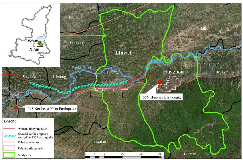
people visualize the estimated losses and impacts, and provide mitigation and preparedness
recommendations that, if implemented, will help reduce earthquake damage and consequences.

Key words: Transdisciplinary; participatory; narrative; storytelling; landslides; loss estimation

1. Earthquake scenarios: international experience and implications for China

    Scenarios have emerged over the last few decades as a useful method to bring together physical,
environmental and social scientists, engineers, policymakers, government agencies, private sector
companies and citizens to plan for possible future events. They provide a forum to assemble
existing scientific and other forms of knowledge about what might happen and to decide
collaboratively what could be done to mitigate the impact of harmful events, or maximize the
benefit of positive events. They have been used for a very wide range of events, including defense
planning (for example by RAND Corporation) to develop a large scale early warning system for
incoming ballistic missiles [1], governance reform (for example the Mont Fleur scenarios to
deliberate the future of South Africa after the end of apartheid in 1991-92 [2]), and most relevant
to our purposes, for planning to mitigate the impact of natural disasters (for example the United
States Geological Survey (USGS) California ShakeOut earthquake scenario [3]).
    Since the 1960s, scenarios have been used to understand and communicate the potential
consequences of earthquakes, and as a basis for mitigation, preparedness, response and recovery
planning. In California alone, scenarios have been used to inform disaster preparedness planning
for local, regional, state and federal authorities; to develop guidelines and municipal ordinances
for residential seismic strengthening; to provide guidance for policy and legislation development
in scenario-affected regions; to serve as the basis for large-scale preparedness exercises; and to
inform development of response, recovery and resilience plans. As used in this paper, an
earthquake scenario refers to a study of the consequences from a specific, hypothetical earthquake,
conducted for the above purposes. The same approach can be used for other natural hazard events.
A scenario includes the technical “core” consisting of a loss estimate and documentation of how
the estimate was made, along with a description of impacts, often in narrative form that presents
the hypothetical disaster unfolding. Some scenarios also include recommendations to reduce losses
and action plans to implement them, or specialized products for public communications and
response simulation exercises. The scope, level of technical detail, and presentation style can vary
widely between scenarios, but all share the common intent of presenting risk information in a way
that allows the audience to conceptualize potential damage and its consequences. Guidance on
scenario preparation, based on experience described below, is available from several sources (e.g.,
[4,5,6]).
    A detailed, 15-year-long study of the effects of a repeat of the 1923 M7.9 Kanto earthquake on
contemporary Tokyo, released in 1978 (described in [7]), was probably the first comprehensive
earthquake scenario. In the early- and mid-1970s, the US National Oceanic and Atmospheric
Administration (NOAA) and USGS released a series of loss estimates for potential US West Coast
earthquakes [8,9,10,11], which were the beginnings of earthquake scenario use for preparedness
in the US. Beginning in 1980, the California Division of Mines and Geology (CDMG, now the
California Geological Survey) began to prepare infrastructure-focused earthquake scenarios for
planning purposes (e.g., [12,13]). FEMA-176 [14] includes a list of early studies in the US, and
lays out a significant portion of the conceptual framework that later scenario studies would follow.
During this period and in the decades that followed, much practical progress was made in

                                                 2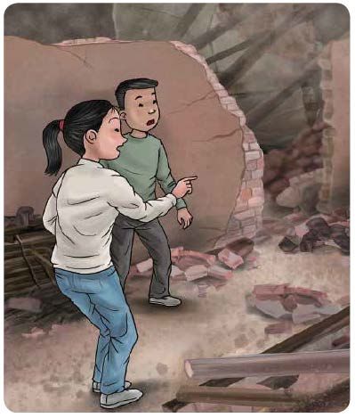
earthquake loss estimation (e.g., [15,16]), including the debut of freely available HAZUS loss
estimation software, which supported more robust scenario studies.
    In the 1990s, GeoHazards International (GHI) pioneered the use of earthquake scenarios for
risk reduction in emerging and developing countries, adapting methods from California and Japan.
In early examples of transdisciplinary, participatory approaches to scenario creation, GHI worked
with local professionals to create scenarios in Quito, Ecuador [17] and Kathmandu, Nepal [18], as
well as in additional cities under the RADIUS project [19]. Transdisciplinary approaches involve
practitioners and researchers from multiple disciplines working together with stakeholders to solve
difficult problems (see [20] for further information). GHI’s Kathmandu scenario appears to have
been the first to use the storytelling approach of following a fictional character in its narrative.
GHI’s more recent scenarios include Aizawl, India [21] and three districts in Nepal [22,23,24].
    Meanwhile, use of scenarios for planning continued in the US, with major scenarios by the
Earthquake Engineering Research Institute (e.g., [25,26,27]), and a series of large-scale scenarios
by USGS, including the Southern California ShakeOut scenario [28]. The ShakeOut is probably
the most widely known and used earthquake scenario to date, with extensive public outreach and
communications described in [3]. The most recent is the Haywired scenario [29,30], focused on
earthquake impacts to technology and lifelines in the San Francisco Bay Area. Researchers in
Japan (see [7]; numerous studies by the Central Disaster Prevention Council for internal use; [31]),
New Zealand (recent examples include [32,33]), Colombia (e.g., [34]), Nepal (e.g. [35,36]), India,
Turkey, Kazakhstan, and others also prepared scenarios for similar purposes.
    Because of the long-lasting, painful experience of the 1976 M7.8 Tangshan earthquake, China
began to conduct work on earthquake disaster loss assessment (earthquake loss estimation/ELE)
in 1980 [37]. For example, in 1980, the Institute of Engineering Mechanics, China Earthquake
Administration (CEA) launched a two-year long project on earthquake building damage
assessment in Anyang city, Henan Province [38]; in 1981, the Institute of Geology, CEA and the
Institute of Engineering Earthquake Research, Chinese Academy of Building Sciences, launched
a three-year long program on earthquake loss estimation (ELE) in Yantai City (Shan Dong
province) and Xuzhou City (Jiangsu province) [39].
    In the 1990s, with the start of the UN International Decade for Natural Disaster Reduction
(IDNDR) campaign, the CEA set up the work on ELE as one of its key research topics. In 1989,
CEA established the “Research Group/Task Force on Future Earthquake Loss Estimation”, and
carried out research on “China Earthquake Loss Estimation in the Forthcoming 50 Years” [40,41].
In order to further promote and guide ELE work, the CEA issued the "Work Outline for Earthquake
Loss Estimation (Draft)" in early 1990, which advanced China's ELE to enter a new stage [37]. In
1993, research on “Prediction of Chinese Earthquake Losses with Scale of Ten Years” was carried
out as a national research planning priority [42]. During the “9th Five-Year” planning period (1996-
2000), ELE and earthquake disaster mitigation demonstration research and applications were
carried out in multiple regional cities including Zigong, Sichuan Province, and Quanzhou, Fujian
Province [43]. Reflecting years of progress, the standard GB/T 19428-2003: Code for earthquake
disaster evaluation and its information management system was released in 2003 [44] and revised
recently in 2014 (GB/T 19428-2014, [45]). The basic logic of China’s ELE methodology originated
primarily in the US Applied Technology Council methods (e.g., [15]). As early as in 1991, Chinese
researchers translated ATC-13 Earthquake Damage Evaluation Data for California into Chinese
[46]. Since then, the ATC-series documents have been widely referred to in the nation. Substantial
efforts over the past three decades in China have resulted in earthquake loss estimates for around
40 large and medium-sized cities nation-wide.

                                                 3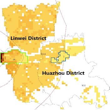
Although significant progress in earthquake loss estimation in China has been achieved, there
is still considerable space for further work, considering the full spectrum of internationally
available earthquake scenario work. The major such areas for ELE in China are as follows:
    • Although the work scope described in GB/T 19428-2014 is quite inclusive, most past
         analyses (especially the early ones) have often disproportionately centered on buildings,
         lifelines, and casualties and direct economic losses caused by damage to them. The analysis
         on other aspects such as earthquake-induced geo-hazards and secondary disasters has often
         been very limited, due to various factors such as resource limitations, end-user
         requirements, and limited availability of certain necessary expertise to assist the work team.
    • Almost all existing ELE studies (i.e., the ELE work conducted for large and medium-sized
         cities) were mainly focused on urban areas, with rural areas barely or seldom addressed.
    • Loss estimates have frequently focused on physical vulnerabilities of buildings and
         lifelines, with limited discussion of functionality and the consequences of damage on
         systems and people, thus reducing practical applicability. Communication between
         researchers and local relevant agencies has often been insufficient, resulting in researchers
         often having limited understanding of actual risks to functionality (i.e., if a water pipeline
         breaks, how many people would be impacted), and end-user agencies often lacking
         understanding of how researchers’ work may be relevant to their responsibilities and
         ongoing work.
    • Existing ELE work mainly aimed to help government and its relevant agencies to improve
         their top-down disaster reduction practices, with little bottom-up consideration on how to
         directly serve the broad civil society, especially the general public and grass-roots groups.
         For example, apart from physical damage of buildings and infrastructure, other situations
         the general public and communities may face (e.g., family and community level impacts
         and response) have barely been addressed. Associated human and social science-focused
         elements have almost never been examined substantively.
    • There has been little examination of contextual information to understand: how the local
         population understands and practises earthquake preparedness; how ELE work can be
         understood and used; and how the work results and products should be made more useful.
    • Past loss estimation work (particularly the earlier estimates) frequently ended with
         production of a report focused on detailed technical explanations of buildings and lifelines,
         with some general, high level recommendations. End-users often found these reports dry
         and difficult to understand, and unmanageable to use, creating a barrier to actually using
         the results to reduce risk. Recently, the products of some ELE work in China also included
         “an information management system” which was often sophisticated in information
         technology and professional in earthquake hazard and disaster analysis but seems more
         suitable for researchers to maintain and use than for end-users.

    Given the above, and with the opportunity provided by the UK Natural Environment (NERC)
and Economic and Social (ESRC) Research Councils and the Natural Science Foundation of China
(NSFC) through their jointly supported project “Pan-participatory Assessment and Governance
of Earthquake Risks in the Ordos Area (PAGER-O)”, we decided to prepare a pilot earthquake
scenario for Weinan area, Shaanxi province, China, using the GHI approaches described above.
The PAGER-O project is one part of the UK-China collaboration programme “Increasing
Resilience to Natural Hazards in Earthquake-Prone regions in China (IRNHiC)", whose aim is to
introduce international experience relevant to China’s earthquake loss estimation work and beyond,

                                                  4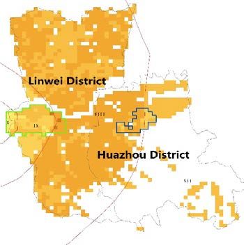
advance earthquake scenario practice where possible, and address simultaneously the government-
identified gap between top-down and bottom-up disaster risk reduction approaches in China
[47,48], to the extent possible.

2. Weinan context

     The study area in Weinan City consists of two municipal/administrative districts (Fig. 1),
Linwei District and Huazhou District, which have a total population of over 1.30 million and a
GDP of 46.55 billion RMB in 2017. Geographically, the study area is east of Xi’an in Shaanxi
Province, along the Weihe River in the Weihe basin that lies south of the loess plateau and north
of the Qinling Mountains. This great difference in the geomorphological point of view among high
mountains, relatively flat Weihe basin, and uneven loess tableland in the area results in a variety
of land use and land coverage. The climate is suitable for agriculture, although occasionally crops
in this area suffer from summer drought and autumn floods. Weinan is a predominantly agricultural
area, but there are also several large-scale chemical factories and thermal power plants, especially
in the study area, which might experience secondary disasters when an earthquake occurs. On the
route between Beijing and Xi’an, Weinan City is well served by multiple transportation modes
including highways, regular and high-speed rail lines, and expressways.
     Tectonically, Weinan City lies in the eastern part of the Weihe basin, south of the Ordos block
of the North China platform, with the active tectonics of the Weihe sub-seismic belt well developed
[49]. The Weihe basin contains a number of active faults (see Fig. 1 in Feng et al. [50], this issue),
and was affected by at least 20 major earthquakes since 600 CE for which historical records exist
(see Fig. 1 in Ma et al. [51], this issue, reprinted from [52]). Destructive earthquakes affecting
Weinan City occurred primarily in two periods, 793-879 and 1501-1568. Between 1501 and1568,
three major earthquakes occurred, including China’s deadliest earthquake to date, the 1556 M 8¼
Huaxian earthquake. This period of strong seismic activity also included the 1501 M7 Chaoyi
and1568 M~7 Shaanxi Gaoling earthquakes (see Ma et al. [51], this issue, for details of the latter),
and three smaller earthquakes with magnitudes of M~5½ [53]. Secondary geologic hazards in the
study area mainly include landslides in rock and loess, surface fault rupture, ground fissures and
subsidence, liquefaction and lateral spreading.

                                                  5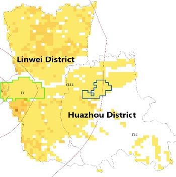
Fig. 1. Map of Linwei and Huazhou districts, Weinan city. Image source: Bing

3. Developing the Weinan scenario: Process

   This section provides a brief overview of the main processes the team used to develop the
scenario. These processes are based primarily on GHI’s practice experience [4,6] and scenario
development practices by others (e.g., [3,5]).

3.1. Project initiation and planning

    The project’s approach was developed collaboratively in planning workshops in Oxford
(January) and Beijing (April) in 2016. We identified key objectives for the scenario development
process, which included:
    • Testing the use of scenario-building as a transdisciplinary process tool for both earthquake
       risk analysis and local engagement on earthquake risk governance in China; and creating a
       model scenario process that local researchers or relevant agencies could replicate in other
       earthquake-threatened areas;
    • Basing the scenario on technically credible science and disaster loss estimates to give
       confidence in the results; and
    • Most importantly, motivating both relevant local agencies and the public to take actions to
       more effectively mitigate earthquake risk and increase resilience.

                                                        6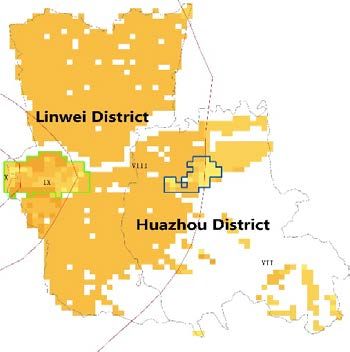
3.2. Scenario city selection

    Through online communications since the initial planning workshop in Oxford, the team
selected the scenario city candidates based on the following main criteria, discussed extensively
during the April 2016 Beijing launch workshop: a) modest population size, to keep the scope
manageable; b) strongly shaken by one of four major historical earthquakes: 1920 Haiyuan, 1739
Yinchuan, 1709 Zhongwei and 1556 Huaxian; c) previous work on historical earthquakes, active
tectonics, disaster loss estimates, earthquake hazard micro-zonation, and disaster preparedness,
along with potential for meaningful additional physical and social science research; d) receptive
local government and community; e) local research and practitioner partners available; f)
representative buildings and infrastructure; g) landslide hazard; and h) China Earthquake
Administration (CEA) or Ministry of Civil Affairs (MoCA) disaster risk reduction demonstration
sites present. We selected these criteria to identify a setting that would allow us to demonstrate
how to address a full range of risk problems including infrastructure, buildings and social issues,
and possible linkages between top-down and bottom-up earthquake disaster risk reduction (DRR)
approaches in China. Labor division was also discussed in this launch workshop, during which
Institute of Geology, China Earthquake Administration (IGCEA) and The Hong Kong Polytechnic
University, China (Poly-U Hong Kong) teams decided to focus on social science-relevant issues
and bottom-up earthquake DRR elements in particular. Between April and November 2016, the
China team visited all candidate cities to meet officials and assess each against the key criteria,
including the level of interest in collaboration, and selected Weinan as the scenario city.

3.3. Initial site visits, field research and planning meetings

    In December 2016, the international team made a technical site visit to Xi’an and Weinan,
including meetings with the Shaanxi Earthquake Administration (Shaanxi EA) and local NGOs in
Xi’an, field reconnaissance in the two districts of Weinan, and meetings with relevant Weinan
authorities and agencies. We held detailed discussions about possible scenario earthquakes and
refining the scenario process for the China context.
    The Chinese team began field research, including a detailed survey of buildings by a team of
over 30 local engineering students, and around 20 Shaanxi EA staff; interviews and analysis of
mobile phone data to gather information on building occupancy; visits to water, power and
telecoms companies; and collection of information about existing earthquake preparedness and
response capacity of government agencies. Research work on preparing shaking intensity maps
began. The Chinese team visited the UK in May 2017 to meet with, share experiences with, and
learn from other groups working on earthquake disaster risk reduction.

3.4. Charrette 1

    In June 2017, the team held a charrette, an intense, focused collaborative effort to solve a
problem, a process originating in architecture, in Weinan and Xi’an. This charrette focused on
understanding the main earthquake risk problems in Linwei and Huazhou districts. Using field
charrette processes GHI developed in prior scenario work in India, team members from multiple
disciplines spent time together in the field to jointly observe tectonic features and geologic
evidence of historical earthquakes (including earthquake induced landslides), lifelines, rural and
urban buildings, schools, hospitals and DRR demonstration communities. The team met frequently

                                                  7
to review emerging data and ideas, held large-scale participatory stakeholder consultation
meetings with officials in Xi’an and Weinan, and selected the scenario earthquake.
3.5. Scenario preparation and review
Following Charrette 1, the Chinese team prepared loss estimates for buildings in rural and
urban areas of the scenario districts, and further explored vulnerabilities of lifeline infrastructure
(see the subsequent technical approach and methods section for discussion). The Chinese team
visited California in October 2017 to meet with organizations involved in earthquake safety and
scenarios, and to work with GHI to review the loss estimate results and identify missing
information. In November 2017, key international and Chinese team members met in Beijing to
present the emerging scenario findings to officials from Shaanxi and Weinan EAs, and agree on
the next steps including the most useful products and mechanisms for local engagement and action
planning. At this meeting, we agreed on a storytelling approach, and began to prepare the narrative
story. Following this meeting, the IGCEA team began to prepare for a large-scale questionnaire
surveys to understand local people’s awareness of earthquake risks and, personal and household
earthquake resilience, and relevant disaster preparedness across the Weinan prefecture. In addition,
the Poly-U Hong Kong team performed face to face interviews in three villages within the study
area, specially probing the relationship between poverty and natural-hazard related disasters (Yu
et al. [54], this issue). The purposes of these surveys and interviews included addressing, in
particular, bottom-up earthquake DRR issues and to inform the development of the narrative story.
3.6. Charrette 2
The second transdisciplinary field charrette in May 2018 was timed to coincide with national
events to mark the 10th anniversary of the 2008 Wenchuan earthquake, and focused on discussing,
presenting and ground-truthing estimated impacts of the scenario earthquake with local agencies
and experts. We presented emerging findings (e.g., building loss estimation results) to government
officials in Weinan, and consulted with earthquake administration officials and experts in Xi’an to
finalize the most effective form and content of the narrative and start the action-planning phase.
We held collaborative writing sessions to improve the narrative and incorporate local feedback.
3.7. Scenario finalization and closing workshop
We incorporated all of the local feedback from Charrette 2, prepared the final building loss
estimates, and completed estimates of landslide probability and likely impact on lifelines. We then
worked with an illustrator and a book designer to create the scenario narratives for audiences
consisting of the general public and local officials, with their input, in both Chinese and English.
We presented these draft documents at a January 2019 workshop in Beijing, with participating
Chinese experts and officials from CEA, UNICEF China, Beijing Normal University, Ministry of
Emergency Management, the Chinese Academy of Sciences, and both Shaanxi EA and Weinan
EA acting as peer-reviewers, to obtain feedback on the scenario narratives and the replicability of
the transdisciplinary project approach. The workshop produced 30 immediate recommendations
to improve communication products, which were incorporated in the final versions of the scenario
narratives, as well as exploring ideas for wider replication of the approach. The team also reviewed
the overall achievements of the project against the original objectives as set out in the PAGER-O
project’s original proposal and “Project Initiation and Planning” section in an internal team
8meeting. The final project results and products were presented at the IRNHiC program-end
workshop in Beijing in March 2019, during which two officials from the Huazhou earthquake
office of Weinan also attended, reflecting the continuing participation of the relevant local officials
during the entirety of this scenario development effort. The project results and products were well
received.
4. Preparing the Weinan scenario: Technical approach and methods
This section provides an overview of the methods used to generate scenario results, which
other papers in this issue describe in detail. The scenario development team realized that sharing
local data is very complex, resulting in all direct work with local data being accomplished by the
China team members alone, as the international participants could not access local data.
International participants worked with summary results that the China team provided and data
available outside China, such as publicly available satellite imagery. Any references to the team’s
direct use of local data refer to China team members only.
4.1. Selecting the scenario earthquake and estimating shaking
The team confined its consideration of possible scenario earthquakes to repeats of historical
earthquakes, for two principal reasons. First, communication of the risks and mitigation strategies
is more direct if they are based on a real, rather than hypothetical, earthquake. Second, had we
chosen to place the scenario earthquake on one of the active faults in the region that have not
hosted a historical earthquake, there would have been the unavoidable risk that some would regard
our choice as resembling a forecast of future seismicity. We considered three historical events: the
1501 M7 Chaoyi, 1556 M 8 ¼ Huaxian, and 1568 M~7 Shaanxi Gaoling earthquakes. Of these,
we selected the last, because it generated strong but not completely devastating shaking in Linwei
and Huazhou (Ma et al. [51] and Chen et al. [55], this issue). Given the number of active faults in
the Weihe Basin, the team’s earth scientists considered this level of shaking to have a plausible
likelihood of occurring, within the next 100 years, somewhere within the region of responsibility
for the authorities with whom we were engaged.
In contrast, a ~M8 earthquake, like the 1556 Huaxian event, is expected to occur on the
Huashan fault once in more than 5,000 years. Studies of how humans perceive risk (see [56]) and
past scenario user needs assessments [14] indicate that it is difficult to motivate action to prepare
for threats of such rarity. The 1568 earthquake was preferred to the 1501 Chaoyi earthquake
because the causative fault is now well characterized (Feng et al. [50], this issue) and the historical
record of ground shaking can be reliably related to the fault (Ma et al., this issue). Furthermore,
the epicenter of the 1501 earthquake was too far east to produce damaging shaking in urban Linwei
District or the loess tableland, both of significant interest for scenario studies in this area.
Estimates of ground shaking for the 1556 and 1568 earthquakes were prepared using the
methods of Chen et al. ([55], this issue), to confirm that the M~7 1568 Shaanxi Gaoling earthquake
was the appropriate choice. Local ground motion prediction equations (GMPEs) are not available
for the Weihe basin and, although commonly used GMPEs contain some information from
earthquakes within mainland China, such data are sparse and it was considered essential to
compare computed shaking intensity distributions with historic isoseismals for the M8 ¼ 1556
Huaxian earthquake, which is the best documented of Weinan’s historical earthquakes. It was
found (Chen et al. [55], this issue) that a satisfactory fit to the historical isoseismals could be
9obtained by using intensities having a uniformly lower probability of exceedance than predicted
by the median values of the parameters to the GMPE ASK13 (see Chen et al. [55], this issue,
Figures 4 and 5). The same GMPE and modelling assumptions used for the 1556 earthquake were
then used to compute shaking intensity distributions for the scenario repeat of the M~7 1568
earthquake, for which considerably less historic documentation is available. Based on studies by
Feng et al. ([50], this issue), this earthquake was modelled as occurring on a 56-km segment of the
Weinan-Jinyang Fault, a 105km nearly east-west striking, north-dipping normal fault.
4.2. Determining effects of potential fault rupture, liquefaction, and lateral spreading
According to recent studies (Feng et al. [50], this issue), causative Weinan-Jinyang fault
ruptured the surface in the 1568 Shaanxi Gaoling event, so the scenario assumes that surface
rupture occurs. Based on published scaling relationships [57], the amount of offset in the scenario
event is estimated to be between 0.6 m and 1 m, which is consistent with geologic observations of
offset on the order of 1 m (Feng et al. [50], this issue). The assumed scenario surface trace was
overlaid on satellite imagery to determine whether the scenario surface rupture would intersect
infrastructure.
Past earthquakes, including the 1556 M 8¼ Huaxian and 1501 Chaoyi earthquakes [52,58]
have triggered liquefaction in the Weihe basin. Based on liquefaction potential maps (Shaanxi
Earthquake Administration, unpublished report, 2011) reviewed by IGCEA team, saturated
alluvial soils near the Weihe River and local tributaries such as the Youhe River are expected to
be particularly susceptible to liquefaction. (Liquefaction refers to the phenomenon that occurs
when saturated sandy soils lose their strength due to earthquake shaking, often associated with the
flow and ejection of subsurface water and soil onto the ground surface.) Near the Weihe River,
liquefaction-induced lateral spreading may occur as subsurface layers of soil liquefy, resulting in
ground settlement, and large blocks of soil above them slide toward the free faces created by the
river’s steep banks. The team qualitatively estimated the impacts of liquefaction on infrastructure
by comparing the areas of liquefaction potential against infrastructure locations.
4.3. Estimating the extent of coseismic landslides
Several major northern China earthquakes since 1900, including the 1920 Haiyuan and 2008
Wenchuan earthquakes, have triggered numerous and deadly landslides. Historical records
indicate that the 1556 Huaxian earthquake [52,58] and the 1568 Shaanxi Gaoling earthquake (Ma
et al. [51], this issue) also triggered landslides in the Weinan area, but there is less detailed
information on the extent of landsliding or its consequences. Because landslide hazard appeared
significant, the PAGER-O team collaborated with researchers from a related project on
Community Based Disaster Risk Reduction in China (CBDRRiC), part of the same IRINHiC
China-UK collaboration program as PAGER-O. CBDRRiC researchers developed estimates of the
likelihood of significant landslides (>100 m2 in area) during the scenario event (Milledge and
Densmore, unpublished report, 2018). Technical details of the methodology are reported here,
because, unlike other components, they do not appear elsewhere in this issue.
To create estimates, Milledge and Densmore (unpublished report, 2018) differentiated between
areas underlain by loess and by bedrock because these rock or stratum types show important
differences in coseismic landsliding. Hill slopes within the Weinan region considered by PAGER-
O can be divided into two broad material types that have very different material strengths: loess,
which is weakly-consolidated fine-grained sediment deposited by wind, and all other rock types,
10collectively termed ‘bedrock’. While this is a very simplified division, it is noticeable at the
landscape scale. Loess underlies the broad tableland immediately to the south of urban Linwei
district (colloquially, Weinan city) and the short but steep hillslopes that form the margins of the
tableland and the valleys that dissect it. Bedrock underlies the higher mountainous areas to the
south and southeast of Weinan city.
Landslide hazard was estimated with statistical models trained on exemplar coseismic
landslide inventories: the 1920 Haiyuan earthquake for loess areas, and the 2008 Wenchuan
earthquake for bedrock areas. Landslides triggered by the Haiyuan earthquake were derived from
the inventory of [59], while those triggered by the Wenchuan earthquake were derived from the
comprehensive inventory of [60].
For each inventory, logistic regression was applied to develop a functional relationship
between peak ground acceleration (PGA), skyline angle of the topography, and landslide hazard
(the probability that a grid cell is covered by either scar or runout). Skyline angle was calculated
for each 90x90 m pixel (using [61]) from SRTM digital elevation data with a 90 m spatial
resolution. PGA estimates for the Wenchuan earthquake are from the USGS ShakeMap version
3.5.1586 [62]. Haiyuan earthquake shaking intensity estimates are from the Seismological Institute
of Lanzhou, CEA and the Seismological Team of Ningxia Hui Autonomous Region (quoted in
[59]), converted to Modified Mercalli Intensity (using Appendix I of GB/T 17742-1999) and then
to PGA (using [63]).
Logistic regression equations were applied to forward-predict landslide probability for the two
separate domains in the Weinan study area mapped as loess and bedrock, using the parameters
from their respective exemplar earthquakes. The same method as for the training inventories [61]
was used to derive skyline angle from SRTM elevation data. PGA estimates for the PAGER-O
scenario earthquake were linearly interpolated to the same 90 m grid. Finally, the two coseismic
landslide probability predictions for loess and bedrock areas were combined to generate a single
landslide hazard map. Use of different logistic regression equations for the two different domains
is a novel feature of this work.
Ten scenario realizations of landslide occurrence were generated from the landslide probability
map to provide an indication of potential landslide impacts that could be more readily understood.
Loess and bedrock domains were treated separately, picking landslides from the appropriate
empirical size distributions of the Haiyuan [59] and Wenchuan [60] inventories, then randomly
assigning their locations guided by the landslide probability from the hazard map and constrained
by a feasibility rule such that landslides were only placed where there was sufficient relief for them
to occur. The total landslide area for each realization was defined by the expected landslide area
from the landslide probability map.
4.4. Modeling building damage, casualties, and direct economic losses
Two research teams prepared loss estimates related to building damage in the urban and rural
areas of Linwei and Huazhou districts, respectively. Due to significant differences in the building
stock and number of buildings to cover, the teams used different approaches. Li et al. [64] and Liu
et al. [65] (this issue) from Institute of Geology, China Earthquake Administration (IGCEA) and
China Earthquake Networks Center (CENC) presented new methods involving the combination of
remote sensing, building-relevant local knowledge, and broad online data resources [66,67] used
for rural areas, while Wang and Gao [68] and Wang and Wang [69] (this issue) from China
Earthquake Disaster Prevention Center (CEDPC), described new methods used for urban parts,
though the central logic of loss estimation calculations adhered to existing, tested approaches that
11are described in the relevant national standard GB/T 19428-2014: Code for earthquake loss
estimation and its information management system [45].
Both teams collected large georeferenced building inventory datasets, and followed the general
procedures in government standard GB/T 19428-2014.These procedures specify that estimates of
damage be made for each intensity VI through X on the Chinese Seismic Intensity Scale
(GB/T17742-2008, included as an appendix in Ma et al. [51], this issue). Using the scenario
shaking intensity maps from Chen et al. [55] (this issue), the research teams assigned the correct
intensity to the georeferenced building inventory with the help of the spatial-join tool of ArcGIS
V10 software to arrive at the overall loss estimate. Damage matrices and vulnerability functions
that form the basis for building damage estimates were developed using damage data from Chinese
historical earthquakes. For urban areas, this included a large database of damaged masonry
buildings [70] and published damage data from the 2008 Wenchuan earthquake and several
subsequent earthquakes in China with M>6. For rural buildings, vulnerability functions were
created on the basis of historical destructive earthquake records and corresponding earthquake loss
evaluation compilations (1993-2016), employing the fitting method of beta probability density
functions (BPDF), in order to estimate losses for intensities above VIII for which data are scarce,
as Li et al. [64] (this issue) describe. Casualties and economic losses were estimated using
published relationships [70] based on data from less recent Chinese earthquakes. We assumed the
scenario earthquake occurs at 2:02 pm on a Saturday in April.
4.5. Understanding potential threats to utility infrastructure and transportation systems
Like any sizeable city, Weinan relies on its water, electric power, communications, gas and
fuel, and transportation infrastructure to function. Weinan is located in a key corridor between
Xi’an and Beijing (more broadly, between eastern and western China), and important
transportation routes such as the G30 expressway, National Road 310, and regular and high-speed
rail lines pass through Linwei and Huazhou districts. Weinan’s location in the Weihe basin means
that components of these infrastructure systems are located in areas susceptible to ground failure,
cross active faults, or are close enough to them to experience strong shaking. Infrastructure
locations are also constrained to some degree by the presence of the Weihe River floodplain; the
G30 expressway and regular rail lines run just north of the northern margin of the Weinan loess
tableland, and of the Huashan mountain front, avoiding the floodplain. Only the high-speed rail
line and local roads and rail lines are located out in the basin.
We focused on identifying concerns about the intersection of utility and transportation
infrastructure with known geologic hazard areas, such as locations where infrastructure crosses
active faults and areas of heightened landslide susceptibility or high liquefaction potential. Publicly
available satellite imagery and limited field observations were the main tools to understand the
severity of geologic hazard impacts on them.
Because water systems are critical for overall resilience of an area and past earthquakes
demonstrate that system damage frequently causes water service interruptions [71,72,73]. The
team’s water system engineer, landslide geologist, and structural geologists conducted joint
fieldwork with local EA and water agency staff at the key water infrastructure sites, such as the
main drinking water reservoirs and treatment plants. This transdisciplinary process allowed the
team to rapidly understand the multiple disciplinary dimensions of the water system’s earthquake
risk problems. Based on these consultations with local water professionals/staff and fieldwork, we
developed a qualitative understanding of the four subsystems (using the classification of [72]) that
comprise the water supply system in Linwei and Huazhou districts: raw water supply systems,
12treatment systems, transmission systems and distribution systems, and of their potential seismic
and seismic-induced geo-hazard vulnerabilities.
As frequently occurs in other countries due to security concerns, it was difficult for utility
system operators to share information on their systems with anyone outside the organization. This
is particularly true for operators of electric power and gas systems; the team was able to obtain
only minimal information on these systems. However, utility and transportation system operators
can use this scenario as a starting point to prepare their own detailed loss estimates for their
systems, using the scenario shaking and identified areas of higher susceptibility to ground failure
of various types. We also investigated infrastructure interdependencies qualitatively, with a focus
on identifying areas in which damage and loss of function in one system would substantially
adversely impact another.
4.6. Understanding social impacts and bottom-up earthquake DRR-focused issues
Apart from modelling typical impacts on the local population and economy, such as casualties,
injuries, ‘homeless population’ who need temporary shelter, and direct economic loss, (see Li et
al. [64], this issue), and trying to understand in the sense of a pilot study what other situations the
general public and local community (village) would face, apart from physical damage of buildings
(see Liu et al. [65], this issue), we particularly emphasized on how aware local people at the grass-
roots are of earthquake issues, to what extent they have practised earthquake preparedness and
mitigation, and how resilient they are currently. We believe this context is a contributing factor
that helps determine whether our scenario work can be understood and used more broadly, and if
so, how we should make our results and products more useful. We also believe understanding this
context is crucial for improving relevant bottom-up earthquake DRR approaches.
To obtain this big picture, the IGCEA team, collaborating with educators from Beijing Normal
University, firstly proposed an education-oriented framework of public awareness of earthquake
disasters and two actor level-sensitive models of personal and household earthquake resilience.
For the awareness framework, we established it after carefully examining the implications of
UNISDR’s general term of public awareness [74], systematically summarizing our 10 year-long
similar prior work (e.g., [75]), and incorporating the enlightenment through careful study of what
Environmental Education Objectives mean [76,77] in particular. We value UNESCO-UNEP's
Environmental Education Objectives because they are all very “actual application-oriented,” thus
we think the proper intake of such understanding of UNESCO-UNEP is also helpful for dealing
with practical earthquake disaster education issues, and beneficial for society by raising people’s
earthquake disaster awareness through better education practices. Generally, UNESCO-UNEP's
Environmental Education Objectives are as follows: to help individuals and social groups to
acquire “awareness, knowledge, attitudes, skills” of/for (resolving) environmental problems and
to facilitate them to “participate” in actual actions. For the two resilience models, we mainly based
them on our similar prior work (e.g., [75]) and UNISDR’s definition of resilience [74,78], and also
incorporated relevant pieces from disciplines outside geo-sciences and engineering, including
understanding of people’s psychological resilience and family resilience from psychology and
family studies [79,80,81,82]. With these frameworks and models, we then developed a large set of
earthquake disaster awareness and resilience measurement questionnaires (over 20 in total). These
tools closely align with broad China contexts (e.g., the nation’s powerful and effective top-down
disaster management, which might cause the general public to shift too much responsibility to the
government and lower their own motivation to prepare) and various local realities (hazard and
disaster, building and housing practices, disaster management, education and disaster education,
13etc.) and to deliberately target different public groups: primary and high school students in
different grades, their parents and teachers, and broad general public. In 2018, both pilot and
formal surveys that covered almost the entire Weinan prefectural area (not just Linwei and
Huazhou districts) were completed, with over 15,000 copies of various questionnaire data
collected.
With a multi-hazard point of view, the Poly-U team then used structured face-to-face
interviews to look at hazard and disaster understanding, and actual disaster reduction practices of
the rural population in the study area. They conducted interviews in three carefully selected sample
villages (communities) in Linwei district, which have distinct topographical and geomorphologic
differences: Weihe basin, loess tableland, and Qinling mountains, where commonly experienced
natural hazards are also different. Apart from addressing people’s risk perception, disaster
preparedness, adaptation intentions, interpersonal communications, and associated interaction
mechanism(s) between them, this team particularly emphasized the relationship between poverty
and disasters. The three case study villages are all the government-named “poverty villages” (e.g.,
Yu et al. [54], this issue; and [83]). Incorporating poverty issues becomes very relevant when
dealing with disaster risk reduction, because poverty and natural disasters are frequently “twin
brothers” in many rural areas in mainland China. Poverty alleviation and disaster reduction should
be synergistic; people living in poverty are frequently more vulnerable to disasters (e.g., [84,85];
and Yu et al. [54], this issue). And most importantly, integrating earthquake disaster reduction
mobilization into poverty alleviation activities might be more effective for the general public in
such areas, because people may view strong earthquakes as being too far removed from their daily
life.
Based on these social science-focused studies and thinking, the necessity of conveying the role
that social vulnerability, for example “poverty”, plays in exacerbating disaster risk shaped greatly
the risk communication strategy for the scenario results. This included prominently featuring a
more vulnerable population common in the poor rural area of Weinan, and most poor rural areas
of mainland China—so-called “left-behind children”—as main characters in the fictional narrative
describing what happens during and after the scenario earthquake.
As scenario work progressed, it became clearer that “community-based disaster risk reduction
(CBDDR), school-based DRR, family-based DRR, and broad disaster reduction knowledge
dissemination and education” should be the most feasible and sustainable linkages between top-
down and bottom-up earthquake DRR approaches, because these items are all closely related to
government or its relevant agencies’ daily responsibilities and functions. For example, promoting
“disaster reduction knowledge dissemination and education” has long been a key daily function of
the CEA system. We invested great effort to produce interesting scenario narratives useful for
these DRR education functions.
5. Scenario results and findings regarding Weinan earthquake risk
A repeat of the 1568 M~7 Northeast Xi’an / Shaanxi Gaoling earthquake in present-day Linwei
and Huazhou districts would have devastating consequences: thousands of building collapses, over
2100 deaths, more than 10,000 serious injuries, substantial damage to infrastructure and disruption
of utility services, and over 41 billion Yuan RMB in direct economic losses from building damage
alone which almost equals the present-day annual GDP of the two districts (46.55 billion Yuan
RMB in 2017). Repairing the damage to infrastructure and restoring services would add substantial
costs. Unreinforced masonry buildings, most prevalent in rural areas but also present in urban parts
14of the study districts, would suffer the most damage. Fig. 2 shows the extent of building damage,
using a damage rate allowing comparisons of damage severity.
a b
c d
Legend
Urban area of Linwei Damage Rate (%)
Urban area of Huazhou 0 10 20 30 40 50 60 70 75
Isoseismal line
Fig. 2. Estimated damage rate of buildings with different damage degrees: a) slight damage; b) moderate damage; c) severe damage;
and d) collapse. The regions marked in green and blue respectively show the locations of the urban area of Linwei and Huazhou.
Rural areas in western Linwei district are among the areas that would experience the heaviest
damage, due to very strong shaking. Most rural buildings in these areas were not constructed to
any building code and without any earthquake-resistant measures. In rural Linwei, nearly 9,840
houses with an area of 1.3 million square metres of these masonry buildings alone would collapse,
and a further 22,350 houses with an area of 3.0 million square metres would be too badly damaged
to use. In urban Linwei, small commercial and older residential masonry buildings would also
suffer proportionally heavier damage. Many of these buildings were built before modern
earthquake-resistant codes. In newer buildings, damage to finishes and partition walls would need
repair. Huazhou district is further from the portion of the fault that ruptures, so the shaking is not
as strong and there would be less damage.
15Unfortunately, infrastructure near the northern tableland margin is exposed both to long-runout
loess landslides and to strong shaking and fault rupture from the Weinan-Jinyang fault that runs
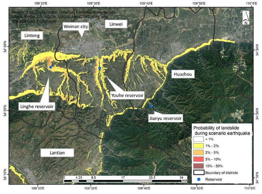
near the tableland margin in this area. Landslides along the margins of the loess tableland
(estimated to be 30-40 landslides with area >8000 m2) and along its valleys (estimated to 70-110
landslides with area >8000 m2) would damage infrastructure, including roads, rail lines and the
Youhe Reservoir, urban Linwei’s secondary drinking water reservoir, and disrupt access to the
tableland, as Fig. 3 shows. In the Weihe River flood plain, liquefaction would damage roads, water
lines, irrigation canals, and buildings. Along the Weihe River itself, thin layers of soil are expected
to liquefy, causing large areas of soil above them to slide slowly toward the river, a process known
as lateral spreading. Floodwalls and embankments would be damaged in several locations, causing
significant damage to flood protection systems for Linwei district. Vertical offsets of up to 1 m
created by surface rupture of the Weinan-Jinyang fault would damage roads, rail lines, pipes, and
flood protection structures crossing the fault.
Fig. 3. Probability of landslides with area greater than 100 m2 during the scenario earthquake. Note the concentration of potential
landsliding along the northern edge of the tableland, located just south of Weinan city, and in the incised valleys within the
tableland.
Damage to the water system would leave some local residents without water service for hours
to months, depending on their location. Some facilities are expected to lose pumping capacity due
to power outages caused by damage to the electrical system. Loess landslides along the tableland
16valley margin may damage the Youhe Reservoir and could affect the dam itself. The primary
drinking water reservoir for Linwei district, the Jian Yu reservoir, is located far enough away that
it should escape any significant damage. Soil failures would damage the canals and buried
pipelines that bring water from the Yellow River to the new North water treatment plant,
interrupting its supply. In the treatment plants, buildings crack and equipment slides and overturns.
Unanchored chlorine tanks would roll from their cradles, break their lines, and release dangerous
gas; these can easily be restrained. In rural areas, brick water towers located above borewells would
suffer heavy damage, and some would collapse. Even towers that have been taken out of service
pose a hazard to people nearby.
These results illustrate several major earthquake risk problems Weinan faces:
• Seismically vulnerable unreinforced masonry residential buildings, both in urban and rural
areas;
• Older hospitals;
• Water system vulnerabilities;
• Areas susceptible to earthquake-induced landslides along the tableland margin and valleys,
and along the mountain front in Huazhou district;
• Areas with soils susceptible to liquefaction and liquefaction-induced lateral spreading;
• Infrastructure (roads, railways, gas pipelines, etc.) that crosses major local active faults or
is exposed to landslides, liquefaction or lateral spreading; and
• Vulnerabilities created by family separation and the prevalence of rural households
consisting of “left-behind” children, grandparents, and in some cases, women.
These risk problems are expected to create substantial consequences in a number of different
potential damaging earthquakes, not only the scenario event. Weinan leaders and residents can
begin to address these problems by taking practical measures such as: educating and empowering
rural owner-builders on construction of earthquake-resistant buildings; replacing older, vulnerable
hospitals with new earthquake-resistant ones and instituting functional continuity programs that
seismically protect equipment and backup utility systems and implement preparedness measures;
improving infrastructure systems and making them more robust and redundant over time; avoiding
new development in geologic hazard zones such as along active faults and areas of high landslide
and liquefaction hazard; and planning for the types of damage and consequences that this scenario
describes. Infrastructure system operators can assess the risk earthquakes pose to their systems,
and prepare their own internal loss estimates and scenarios, as an extension of this scenario.
6. Risk communication approaches to disseminate and use the scenario
We chose to present the scenario’s main findings and recommendations to local officials and
the public using storytelling approaches, in order to make the technical information accessible and
more approachable for people who are not earthquake and disaster professionals, and to motivate
action. Storytelling approaches provide a powerful method of influencing behaviour and decision-
making (e.g., [86,87,88,89]). To do this, we prepared two versions of a fictional narrative that
describe a local rural family’s experiences in the earthquake and its aftermath [90,91]. According
to communications with local officials, they were most interested in the personal story format,
compared with other possible formats such as a technical narrative arranged by topic, a newspaper
17story, and an impersonal narrative arranged by time of occurrence. For technical and research
audiences, including those outside China, we prepared the papers in this issue and elsewhere.
We first prepared a narrative story for local agencies, with boxes, graphics, and maps
presenting the loss estimation results, key technical details, risk problems, recommendations, and
associated earthquake DRR policy information woven into the storyline. The narrative helps
people in these agencies visualize the losses described in the loss estimate, as well as important
impacts–such as lifeline interdependencies–that are difficult to quantitatively model using
currently available approaches, so as to improve to associated top-down DRR practice. Fig. 4
provides an example illustration and a paragraph of the story, describing the reaction of parents
who finally reach their rural family home from the cities where they work (Shanghai and Xi’an)
only to find it severely damaged, and their children, left behind with their grandmother while they
worked, missing.
After four long hours, the truck rolled to a stop in the
lane outside their house, and Haiyan jumped out.
With Jianguo behind her, she ran through the gate
into the courtyard.
“Xiaoshuai! Xiaomei! Ma! We’re here!” she
shouted. Everything was completely still. She dashed
around to the back of the house, and saw the gaping
hole in the back corner. It appeared there had been a
rescue of some sort – bricks were piled in odd spots
and boards of different lengths and sizes were lying
about. That meant someone had been underneath all
those bricks. Haiyan couldn’t breathe for a moment.
Jianguo held her by both shoulders.
“They are going to be okay. They are going to be
okay, Haiyan. Maybe they’re at the Wang or Zhang
house,” Jianguo said slowly. “Let’s go.”
Fig. 4. Example illustration by Siu Kuen Lai, and story paragraph from the narrative version for government officials.
For the general public, we adapted the story into a short graphic novel, removed overly
technical information, and added practical preparedness tips for local families. We carefully
constructed the plot of the story to highlight key earthquake risk problems facing Weinan, such as:
seismically vulnerable rural housing inhabited by populations comprised mainly of older people
and “left behind” children; older seismically vulnerable urban buildings; landslides in the loess
tableland; damage to the health system; and disruptions to transportation, communications, and
utility service. We designed our characters to experience realistic emotions and to model a
progression in attitude from being indifferent to earthquake risk, to actively adopting important
earthquake safety measures such as building an earthquake-resistant house. It is our intent that
readers become educated and then motivated to act to make themselves and their families safer
from earthquakes. We created these two different versions of narratives simultaneously, with the
18You can also read