UPDATE EAST STOKE - The Parish Plan Prepared by the Steering Committee April 2006
←
→
Page content transcription
If your browser does not render page correctly, please read the page content below
UPDATE EAST STOKE

       The Parish Plan
Prepared by the Steering Committee
            April 2006

         © Copyright East Stoke Parish Council 2006
CONTENTS

FOREWORD BY DAVID TOPP                        5

ACKNOWLEDGEMENTS                              5

EAST STOKE PARISH                             6

PART 1        INTRODUCTION AND BACKGROUND     7
1.1    A Picture of the Parish                 7

1.2    Why a Parish Plan for East Stoke        7

1.3    Management Structure                    8

1.4    Research and Consultation               8

1.5    Communications Strategy                10

1.6    Structure of the Plan                  10

PART 2        SOCIAL                          11
2.1    Community Spirit                       11

2.2    Housing                                11

2.3    Education                              12

2.4    Sport and Leisure                      13

2.5    Village Hall                           14

2.6    The Village Pub                        16

2.7    The Farm Shop                          16

2.8    Employment                             17

2.9    Law and Order                          17

2.10   Tourism                                18

2.11   Healthcare                             19

2.12   Communications and Consultation        20

PART 3        INFRASTRUCTURE                  21
3.1    Roads Infrastructure                   21

                                          2
3.2    Highways Maintenance                        21

3.3    Road Safety                                 21

3.4    Purbeck Way                                 23

3.5    Footpaths, Bridleways and Rights of Way     23

3.6    Purbeck Cycleway                            24

3.7    Public and Private Transport                24

3.8    Railways Crossings                          25

PART 4         ENVIRONMENTAL                       26
4.1    Scope                                       26

4.2    Planning and the Environment                26

4.3    River Management                            26

4.4    Flooding                                    27

4.5    Farming                                     29

4.6    Area of Outstanding Natural Beauty (AONB)   30

4.7    Common Land                                 31

4.8    Wildlife                                    31

4.9    Forestry                                    32

4.10   Trees and Hedgerows                         32

4.11   River Laboratory                            33

4.12   Dorset Waste Management Plan                33

4.13   Domestic Recycling                          34

4.14   Energy Conservation                         34

PART 5         HERITAGE AND HISTORICAL             35
5.1    Preservation                                35

5.2    Village History Booklet                     35

5.3    Ruins of the Old St Marys Church            36

5.4    War Memorial                                37

5.5    Village Pound                               38

5.6    The Chapel                                  38

                                             3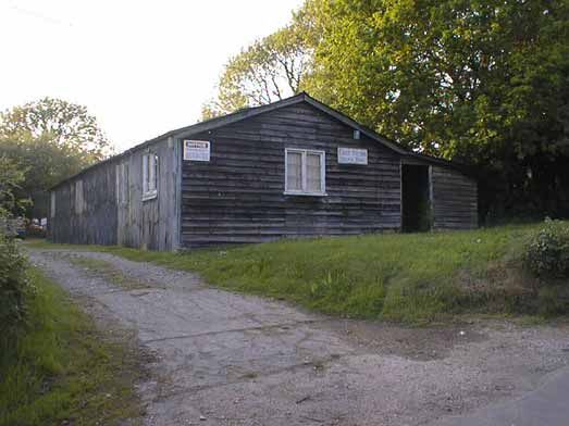
5.7   The Mission Room                            38

5.8   Modern St Marys                             39

5.9   Holmebridge                                 39

PART 6       ACTION PLAN                          41
6.1   General                                     41

6.2   Social Issues                               42

6.2   Infrastructure Issues                       43

6.3   Environmental Issues                        43

6.4   Heritage and Historical Issues              44

ANNEX A – WORKING GROUP TERMS OF REFERENCE        45
A1    General                                     45

A2    Social and Infrastructure Working Group     45

A3    Environmental Working Group                 46

A4    Heritage and Historical Working Group       48

ANNEX B – HOUSEHOLD SURVEY                        49

                                              4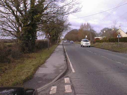
Foreword by David Topp

It was a privilege to be involved with the Steering Committee responsible for preparing this
Parish Plan on behalf of the people of East Stoke. It has been a challenging and sometimes
daunting task; there have been many times when I wondered if we had bitten off more than
we could chew. Producing the Plan has taken slightly longer than originally intended as we
are all busy people with full time or seasonally intensive day jobs. However we have
followed the Countryside Agency model of full consultation with the community to involve
them in the process and we have had some fun along the way.

The dispersed community in East Stoke coupled with the modern way of life makes
community involvement more difficult but we were encouraged by those who did make the
effort to respond to surveys and attend the various meetings and events. We have also had
positive feedback on the Newsletters used to promote the process as well as letters of support
including ideas for benefit of the community.

The results of the consultation process and where appropriate as italicised quotations are
acknowledged in this Parish Plan, which on behalf of the Steering Committee, I commend to
you.

Acknowledgements
We are grateful to the following for their support and contributions during the development of
the East Stoke Parish Plan:

The Countryside Agency and DEFRA, for the essential funding necessary to complete the
plan.

Dorset Community Action (DCA), especially Simon Thompson for his unstinting support and
encouragement together with Andy Lloyd for his assistance with the affordable housing
survey.

Purbeck District Council (PDC), especially Ros Cartwright for her enthusiasm, support and
encouragement throughout together with Lemaki Curulala, Tim Huxley, Jan Dutton, Danni
Nicholl, Chris McDermott and Jon Rae for their contributions.

Dorset County Council (DCC).

South and East Dorset Primary Care Trust (PCT), Rachael MacCready.

Dorset Police: Inspector Angie Downer and Anita Rigler.

Bournemouth University, Professor Iain Hewitt

William Bond, Jenny Goldsack, Nikki Bond, Jeremy Selfe

                                              5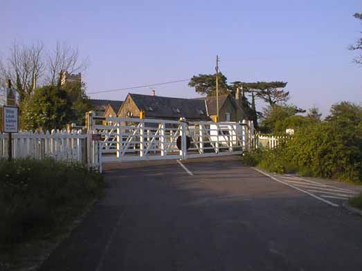
East Stoke Parish

         Scale 1: 50,000. Reproduced from the Ordnance Survey mapping with permission of the controller of Her Majesty’s Stationary. Unauthorised reproduction infringes
         Crown Copyright and may lead to prosecution or civil proceedings. Purbeck District Council Licence LA10002058, 2004.

                                                                                           6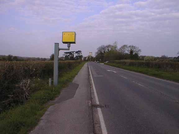
Part 1         Introduction and Background
1.1     A Picture of the Parish

1.1.1   East Stoke is a relatively large rural parish in south Dorset covering some
        1900 hectares (4600 acres). However the density of the population is very low
        with approximately 450 residents and 165 dwellings.

1.1.2   The parish is primarily farmland bisected by the river, A352 road and the main
        Weymouth-Waterloo railway line. It is bounded to the south and west by the
        Army training areas and to the north by active and closed quarries. To the east
        are the parishes of Arne and East Holme, the latter being a similar but much
        smaller parish.

1.1.3   The centre of the parish is approximately 3 miles from the market town of
        Wareham to the east and a similar distance from the village of Wool to the
        west. East Stoke is not a nuclear village but comprises the settlements of East
        Stoke, Stokeford, Rushton, Highwood, Hethfelton, Binnegar, West Holme,
        Holmebridge and Woolbridge. Perhaps this lack of a centre is why it is not
        featured in many guide books. Historically the heart of the parish was
        centered on the church which was originally located in the meadows at East
        Stoke but in the 19th century a new church was built in Stokeford. These sites
        can be identified in the map on page 6.

1.1.4 “East Stoke lacks everything that makes Wool a village e.g. a shop, school,
      playground, surgery and active church.” Most of these amenities have
      gradually disappeared within the last 50 years. The main village shop finished
      in the 1950s, the primary school closed in the mid 1970s, the garage and
      church went in the 1980s and the post office closed in 2001 with only the
      dilapidated village hall and the pub remaining.

1.2     Why a Parish Plan for East Stoke

1.2.1 A presentation on the Vital Villages project was given at the Parish Council
      meeting in October 2003 by Simon Thompson of Dorset Community Action.
      This meeting was attended by members of the parish and several expressed an
      interest in being involved with the development of a Parish Plan.

1.2.2 The Parish Council then voted to prepare a Parish Plan in the New Year as a
      means of engaging the public to determine what exactly people would like to
      see in East Stoke for the benefit of the community and to engender community
      spirit. The Parish Plan is also seen as a valuable tool to support the Parish
      Council in its dealings with local government and other external agencies.

1.2.3   In May 2004 Ros Cartwright from Purbeck District Council (PDC) gave a
        presentation in the village hall on community planning and how the Parish
        Plan linked to the other tiers of community planning at district and county
        levels.

                                           7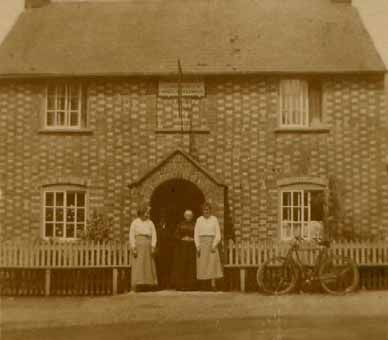
1.3     Management Structure

1.3.1   Following the funding award, a Steering Committee was formed from
        members of the parish who had expressed an interest in being involved with
        the development of the plan; however no formal constitution was adopted.

1.3.2   The Steering Committee has retained largely the same membership
        throughout, though the chairmanship changed at an early stage. Whilst this
        meant that the role of chairman was now vested in the Chairman of East Stoke
        Parish Council rather than a non Parish Council member it has been beneficial.
        There has been continuity of leadership from the submission of the grant
        application to the delivery of the plan. As the other members of the Steering
        Committee are not Parish Councillors, the Chairman’s wider visibility of
        issues within the Parish and at District or County level has been advantageous.

1.3.3   In order to develop the threads within the plan three Working Groups were
        finally agreed to research different topics, engage with the community and
        report to the Steering Committee:
            • Heritage and Historical
            • Social and Infrastructure
            • Environmental

1.3.4   It was originally intended that there would be separate Social and
        Infrastructure Working Groups but as the membership was largely from the
        Steering Committee it was decided to merge the two activities. The output for
        the topics addressed is however reported separately in Parts 2 and 3
        respectively.

1.3.5   Terms of Reference were produced for each Working Group and these are
        included at Annex A.

1.4     Research and Consultation

1.4.1   In the early stages of the development of the Parish Plan (in addition to the
        residents of East Stoke) we identified a number of Stakeholders and agencies
        with which we wished to engage, these included:
            • Dorset Police
            • Dorset County Council (DCC):
               • Senior Countryside Officer
               • Youth Services
               • County Councillor
            • Purbeck District Council (PDC):
               • Environmental Services
               • Planning Department
               • Housing
               • Sport and recreation development
               • District Councillor
            • Purbeck Housing Trust
            • Purbeck Community Partnership

                                           8
• South and East Dorset Primary Care Trust (PCT)
• Local businesses
• Local Landowners
1.4.2 The overall approach was aligned with the Purbeck Community Plan although
the nature of the community in East Stoke means that the topical emphasis in
terms of what is important to local residents varied in some areas.
1.4.3 A household survey was conducted in conjunction with a Newsletter drop
during 2004. The survey covered a variety of topics identified by the Steering
Committee in a workshop and could be completed anonymously though in
order to gauge the demographic range of respondents an indication of age was
requested. It included open and closed questions but was designed to be
concise (2 sides of A4) and not too onerous to complete although additional
comment was encouraged. - It is frightening to answer a questionnaire is it a
threat?” We allowed up to two weeks for responses and the Steering
Committee personally collected the completed forms an approach that had
mixed success. The member who was most successful in retrieving the
completed forms was the one that stated “he would be back the following
evening to collect them”. Had we all adopted this approach then perhaps we
would have done even better than the 52% completion we achieved. A copy
of the questionnaire and summary of the results are included at Annex B.
1.4.4 Regular Public Meetings were held to brief progress and discuss specific
topics including a two day event over the weekend of 6th - 7th November 2004.
Some sixty people attended on each day to see the activities of the three
working groups with some further offers of support and involvement.
Parish Plan Open Day - November 2004
91.5 Communications Strategy
1.5.1 The geographical spread of the Parish is wide and the density of the population
is very low so communication across the community is difficult as there is no
real hub. Within the hamlets that make up East Stoke though people do
communicate and whenever there is a key issue such as planning applications
people will get together and generally the Parish Council will be informed of
local views. In communicating the Parish Plan process and progress made the
communications strategy centred on the use of newsletters, notice boards and
public meetings. Additionally the Parish Plan was a standing agenda item for
the Parish Council with a regular update being provided by the Chairman of
the Steering Committee.
1.5.2 The five notice boards were an essential means of communicating the events
that were planned in the development of the Parish Plan and as all of these
were in poor condition replacement or refurbishment was funded. The notice
boards are well positioned throughout the Parish to provide the best
accessibility by residents.
1.5.3 The Steering Committee produced regular Newsletters that were interspersed
with those produced by the Parish Council to provide frequent updates on the
progress made.
1.5.4 We also tried with varying degrees of success to engage the media particularly
the local press (Dorset Echo and Wareham Advertiser) and BBC Radio Solent
in publicising events but this never resulted in the full coverage of events we
had hoped for.
1.5.5 E-mail was found to be a useful and efficient tool in communicating meeting
notes, agenda and other related information with the Steering Committee,
Parish Clerk and the external bodies, DCA, PDC and the Countryside
Agency/DEFRA.
1.5.6 It was noted by the Steering Committee that the overall communication with
local and national authorities is not always as good as it should be and this is
addressed further in Part 2.
1.6 Structure of the Plan
1.6.1 This Parish Plan is structured such that discrete parts are assigned to the output
from each of the working groups with an exception being that Social and
Infrastructure are given separate parts. Comments from consultation with the
community are shown as italicised quotes.
1.6.2 The Parish Plan is seen as a living document that will be reviewed and updated
periodically in order to maintain its currency and to be of value to the Parish
Council and the community of East Stoke in the future. In particular some
topics not fully addressed by the working groups may be tackled in the future
along with any new issues that may arise.
10Part 2 Social
2.1 Community Spirit
2.1.1 The geographical spread and density of the population within East Stoke
coupled with modern lifestyles makes active participation in community
events more difficult to organise.
2.1.2 However the people of East Stoke have in the past demonstrated community
spirit, for example fundraising events to save the church but most recently for
the Queen’s Golden Jubilee celebrations. This initially started as an initiative
by the residents of Middlefield Cottages but grew to include a Parish wide
event. It is an objective that the Parish Plan will help build on that foundation
and promote a spirit of inclusiveness within the community.
Community spirit in action at East Stoke
2.2 Housing
2.2.1 There are a wide range of property types in East Stoke but mostly they tend to
fall in the upper price bracket for the Purbeck area. There are some properties
for private renting but rents tend to be high and about 10% of all dwellings
within the Parish are second homes or holiday cottages. These second homes
reduce the supply of available and affordable housing for local people or those
relocating to the area through work. In some cases, the owners have extended
their homes resulting in an increase in its value taking them out of the reach of
the first or second time buyer.
2.2.2 Middlefield Cottages originally formed Purbeck District Council’s housing
stock within the parish. This development of 31 bungalows and houses dating
11from the 1950s is now mostly privately owned with only 14 having been
recently transferred to the Purbeck Housing Trust.
2.2.3 A Housing Survey was conducted by the Parish Council in conjunction with
the Rural Housing Enabler at Dorset Community Action during 2003 to
identify affordable housing needs within the Parish. The results showed
support for affordable housing for local people but a very low potential
requirement at only two persons. This was partially to be expected given the
overall population of East Stoke. However recent planning applications
suggest that the potential need is high enough to warrant further investigation.
2.2.4 Statistics produced by PDC showed a large number of family units interested
in affordable housing within East Stoke including about 30% interested in
shared ownership. However all of these have no direct connection with the
parish and it is of concern that there are local young people who are not on the
list because they feel they will never get enough points to qualify for a house.
What the community do not want is for affordable housing to be built which
does not benefit local people.
2.2.5 An Action Plan will therefore revisit the potential requirement for affordable
housing to produce more accurate figures, priorities and local connections.
2.2.6 Determining possible sites for affordable housing within East Stoke presents
its own planning problems as there is no defined settlement boundary therefore
a supportable exception case would need to be made.
2.3 Education
2.3.1 The village school in East Stoke closed in 1977 and the buildings have been
converted to housing. Children from within the Parish now attend various
schools in the surrounding area and statistics provided by Dorset County
Council show this distribution in the state sector to be:
Stoborough First School 3
West Lulworth CE First School 1
Sandford St Martins's CE First School 2
Wool CE VA First School 7
St Mary's Catholic First School, Wool 1
The Purbeck School 21
Wareham Middle School 11
Bovington Middle School 9
Total 55
2.3.2 The consultation process “Education the great debate” for the future of schools
in Dorset was not communicated well by Dorset County Council, therefore the
Steering Committee made best efforts to alert parents to the documents
published on the website and to the public meetings that were being held.
2.3.2 Because of worries about the future of local primary schools and the
combining of age ranges within classes some parents feel that to safeguard
12their children’s education at an acceptable level they have little choice but to
send their children to private schools. It is of concern within the parish
however that those parents that do not have the means to send their children to
private schools have no choice but to accept what is provided by DCC.
2.3.3 This situation is of course driven by demographic trends i.e. falling school
numbers and is inextricably linked to the affordable housing issue for local
young families although this could change with the new housing in Wool.
2.3.4 Outside of the Parish are a number of pre-school nurseries and after school
clubs. Private initiatives aside, there is no ongoing Parish involvement in this
stage of education because parish facilities do not conform to the strict Health
and Safety requirements needed.
2.3.5 The only way that the community within East Stoke are likely to be able to
influence the educational issues is through proper consultation and
representation linked to a combined approach through liaison with the
neighbouring parishes.
2.4 Sport and Leisure
2.4.1 The term leisure is best thought of as use of time other than for work or
domestic chores. Leisure opportunities can be divided into activities and
facilities. These can be further decomposed into formal, informal, structured
and unstructured activities with built facilities and open spaces. Therefore
there is some overlap with the coverage of this topic in this section and how it
is also addressed in other parts of the plan. For example dancing or yoga
classes could require an adequate village hall which is covered in section 2.5.
Similarly cycleways are covered in Part 3.
2.4.2 There are no formal sports and leisure facilities within East Stoke but these are
generally accessible at the Purbeck Sports Centre in Wareham or at the private
facilities in the surrounding area. A small fenced play area is situated at
Middlefield which caters for limited ball games. There is also a yoga class run
at the River Laboratory
2.4.3 The Parish Council also owns a piece of common land available to the
community as a recreation ground though it has not been used as such for
many years. In recent years it has been let for grazing but currently it is let for
private recreational use.
2.4.4 Living in East Stoke offers the opportunity for children to enjoy traditional
unstructured play in open fields, woods, streams and the river in relative
safety. This is considered very important for children’s development though
recognising that structured play in the form of organised games and use of
play equipment should not be neglected. The nearest playgrounds are in Wool
or Wareham which therefore entails a car journey to use them.
13Family fun in East Stoke Mill Stream
2.4.5 In 2003 Middlefield Community Group building on the success of their
Jubilee celebrations launched an initiative to try and provide a playground at
Middlefield Cottages. A playground had been provided in the early 1970s by
the Parish Council but had fallen into disrepair and was removed a few years
ago. East Stoke Parish Council do not have the financial resources to fund a
playground as even a modestly equipped facility would cost around £30,000
and would attract annual running costs of around £1000 to cover ground rent,
insurance, safety inspections and maintenance.
2.4.6 A consultation paper as part of the “Our Space 2” initiative was issued by
DCA on the subject of Play and a comprehensive response was provided by a
member of the Social and Infrastructure Working Group qualified in this field.
This response took into account the responses to the household survey. “Free
play is OK but it would be nice to have some apparatus for all to use within
East Stoke.”
2.4.7 The achievement of an improved outdoor structured play area within the
Parish therefore remains a goal and an action plan will be drawn up to try and
secure funding to achieve this.
2.5 Village Hall
2.5.1 The Village Hall was established just after World War 1 when a former
barrack hut was brought from Wareham Camp and the Village Hall and Social
Club was formed. The building is owned by the Parish Council and the site
has been leased from the local Landowner for a peppercorn rent. The Village
Hall was the centre of social life in East Stoke for many years though more
recently its use has declined.
14East Stoke Village Hall
2.5.2 The Village Hall Committee that had run the hall and social events in East
Stoke since the mid 1970s recently decided to stand down. The majority of
this committee no longer lived in East Stoke and all were now of an age that
they no longer had the energy to continue and thought that it was time to hand
over to a younger team.
2.5.3 The Household Survey results demonstrated that most people that responded
would like to see a village hall continue but recognise that the current building
is at the end of its useful life. This is particularly in respect of modern health
and safety as well as other legislation. The general fabric of the building is in
very poor condition for its current role but some materials could be reclaimed
and re-used for say agricultural purposes.
2.5.4 In August 2005 the Parish Council as sole users of the hall decided to take up
an offer from Brian Godfrey of the Freshwater Biological Association (FBA)
of the use of the conference room at the River Laboratory. The River
Laboratory offers scope for ecological study by the FBA the Centre for
Ecology and Hydrology and the Environment Agency but is seeking to attract
new business as it is an under utilised facility with much to offer the local
community.
2.5.5 There were many suggestions as to the type of activities people have enjoyed
in the past and would like to see in the future. A small number had stated on
the returns that they were prepared to serve on the Hall Committee. Any
replacement building would need to be funded but the aspiration could be for a
more modest facility compared to some of the village halls recently developed
within the Purbeck area.
152.5.6 An interim caretaking committee has been formed to administer the hall in the
short term and this will be expanded in order to implement an action plan for
the long term future of a village hall facility.
2.5.7 The long term usage of the River Laboratory for Parish Council meetings and
other community activities however is not assured and it remains a goal to
achieve a permanent venue under the control of the local community. The
caretaking committee have had discussions with the landowner as a key
stakeholder over the future of the Village Hall site and have obtained his
support and buy-in to the process.
2.6 The Village Pub
2.6.1 The Stokeford Inn formerly called the Black Dog has been the village pub for
over a hundred years and central to social life in East Stoke in the past. The
current landlord has kept the house since 1990.
2.6.2 The Household Survey however showed that it is not well used by the
residents of East Stoke. This is considered to be due to the position on the
main road away from the centre of habitation combined with a general trend
whereby people have more sophisticated tastes preferring restaurants in the
towns or, because of drinking and driving, entertainment at home.
Village Pub circa 1910
2.7 The Farm Shop
2.7.1 Goldys Farm shop on the B3070 has an ethos of providing a good outlet for
locally sourced fresh vegetables and other produce. It is collocated with the
16Holme Farm Nurseries and well supported by the wider local community and
passing trade.
2.7.2 The Household Survey results (although some seemed unsure as to where it
was) showed that it was also fairly well used by the residents of East Stoke as
it was now the only real shop within the Parish. The Proprietor was involved
in the preparation of the survey questions and included “what else might be
provided by the Farm Shop?” Although some stated there was a requirement
for a post office facility to replace that lost in 2001 most people felt they
would be content to travel to Wool or Wareham.
2.8 Employment
2.8.1 There are a number of sources of employment within East Stoke principally
these are:
• Tourism - hotel, guesthouses and campsites
• Agriculture and agricultural diversification
• Mineral extraction - quarries
• Other small businesses operated from homes or other premises.
• Care facilities.
2.8.2 Whilst the number of jobs within the Parish is relatively high compared with
the population of working age residents, a straw poll showed that the number
actually filling jobs within the Parish with the exception of those self-
employed is very low.
2.8.3 However taken as a whole the number in local employment is encouraging.
The reasons why people work where they do are complex reflecting changing
national social trends, ambitions and rewards, individual skills and trades, cost
of housing, family ties and so on.
2.8.4 This is an area that merits further investigation as it informs the development
of the Community Plan for Purbeck and provides valuable data to enable more
informed responses to be provided for the various surveys and initiatives
originating at District, County and National level.
2.9 Law and Order
2.9.1 The crime levels within East Stoke are generally very low as one would expect
in a rural community however that is not to say that people are not concerned
about the safety of themselves and their property. Police manning levels are a
concern and in common with other parishes in Purbeck we were not impressed
with the recent rushed consultation over Force mergers. It is currently difficult
dealing with a call centre in Bournemouth where they do not know the local
area, it will be increasingly so if that call centre is in the future in Exeter.
2.9.2 The visible policing presence in East Stoke is limited to the helicopter passing
overhead and police cars speeding along the A352. The Community Support
Vehicle does not visit but a Community Beat Officer (CBO) to cover a rural
area that included East Stoke was appointed in 2004. He never actually
17engaged with the community before he went long term sick and retired. A
replacement was appointed in early 2005 and came to one Parish Council
meeting attended by the public but then she too went sick and was
subsequently transferred to other duties. It is the intention of the local
Inspector in Wareham that another CBO will be appointed in 2006 and the
hopefully the community can build a rapport to tackle crime prevention and
detection.
2.9.3 Currently there is appears to be a difference between what is known by those
gathering crime statistics at county level, what is known by the local
community and the police station in Wareham. There are a number of
warning and reporting schemes operating within the Parish including Home
Watch, Camp Watch and Farm Watch that are coordinated from the Divisional
Police Headquarters. The Watch schemes however are somewhat stove piped
in the reporting process and the Parish Council as a focal point are not
included in the loop. The community wishes to be better informed.
2.9.4 Local crime tends to be theft from outbuildings particularly from agricultural
or commercial premises. The CBO could again provide a visible police
presence during working hours maintaining links with the local community
and providing a two way feedback on local crime.
2.9.5 Antisocial behaviour within East Stoke is thankfully rare but there have been a
number of illegal Raves held at sites on the Puddletown Road which have
caused a nuisance and disturbed the sleep of both local residents and visitors.
The police and Environmental Health Officers have been somewhat impotent
in their tackling of this issue though the Parish Council has been proactive in
encouraging landowners to take steps to provide better security for their sites.
The CBO again is seen as having a key role in learning from experience and
bringing together the stakeholders to try and avoid the reoccurrence of Raves.
2.9.6 An objective is to lobby for the early reinstatement of the CBO and to better
coordinate the crime prevention efforts within East Stoke. This could include
including crime prevention as a standing item on the Parish Council Agenda
and also as regular topic for the Parish Newsletter.
2.10 Tourism
2.10.1 Tourism is important to Purbeck and the local economy. Within East Stoke
Parish, Kemps Hotel, the Stokeford Inn, the three licensed campsites, and
several bed and breakfast establishments provide accommodation for visitors
to the area. The “Monkey World” ape rescue centre also lies within the
western parish boundary.
2.10.2 Why do people come to East Stoke? The reasons are varied but include:
• The campsites which all lie within the AONB have many regular visitors
who return year on year because they enjoy the peace and quiet of the sites
which are situated in relatively unspoilt countryside. For this type of
visitor good washroom facilities are important but they do not want over
18development with the club houses and organised entertainment found on
some of the larger coastal sites.
• East Stoke is well positioned for access to the many tourist attractions both
close by in Purbeck such as Lulworth Cove and the Jurassic Coast,
Monkey World and the Tank Museum as well as those a little further away
such as the beaches at Studland, Swanage and Weymouth.
• The cost of campsites and accommodation is competitively priced.
2.10.3 What would visitors like to see improved in East Stoke? Consideration should
be given to conducting a simple survey of visitors at the campsites, hotel and
B&B to gather data that could assist in providing informed responses to
questions on planning, infrastructure improvements or environmental issues.
2.10.4 What could we do to promote tourism in East Stoke? There are amenities and
aspects of the natural and built heritage within East Stoke that may be of
interest to visitors and these could be promoted through the development or
awareness of:
• A heritage trail
• Links to the Purbeck Way
• More cycleways or promotion of quiet lanes.
• Footpaths
• Local sport and recreational facilities such as fishing, shooting and gliding
2.11 Healthcare
2.11.1 Healthcare for East Stoke residents is provided through the South and East
Dorset Primary Care Trust (PCT) facilities in Wool or Wareham. There are
263 residents registered as patients with the Health Centre in Wareham
219 residents registered as patients with the Surgery in Wool.
2 residents registered as patients with the Surgery in Bere Regis.
2.11.2 Within the PCT there are four community hospitals: St Leonard’s Hospital,
Swanage Hospital, Victoria Hospital Wimborne, and Wareham Hospital.
These community hospitals provide a wide range of services to their local
population including rehabilitation services, outpatients clinics, diagnostic
services and in-patient and day care surgical treatments, although not all
services are provided at all of the four hospitals. St Leonard’s and Wareham
Hospitals are also the bases for the intermediate care schemes in East Dorset
and Purbeck respectively.
2.11.3 The health related issues considered during the development and compilation
of the Parish Plan and following consultation with the PCT included:
• The age of the population.
• Any issues relating to carers i.e. those people caring for anyone with a long
term illness.
• Volunteers in the community.
19• Access to shops - access to healthy foods.
• Access to sport/physical activities – e.g. activities in the village hall.
• Transport.
2.11.4 The difficulty with addressing these issues in any depth was intrusion and
confidentiality but we found that most were covered either by support from
family, friends and neighbours or the extant Social Services or healthcare
system. Therefore we decided that the pragmatic approach was to provide
information supplied by the PCT at the Open Days for example the use of the
Purbeck Sports Centre facilities through the GP referral scheme and to
communicate health care information in the Parish Newsletter.
2.11.5 The PCT states in their booklet “The Way Forward” that the general health of
the Trust’s population is good, with 92.1% in East Dorset and Purbeck
reported as being in fairly good health (source 2001 Census). However in the
same Census, people over the age of retirement, 9.3% of East Dorset and
Purbeck reported as having limiting long term illness.
2.11.6 A representative from East Stoke was appointed to the Patients Involvement
Group (PIG) for Wool surgery and representation from within the Parish was
also sought for the “Shaping Health” scheme. A goal is to have regular liaison
with the PCT in order to communicate issues such as these to the Parish and to
provide feedback where possible to inform the review of the PCT core values.
2.12 Communications and Consultation
2.12.1 It is considered essential that at local and national level the people of East
Stoke are properly consulted through effective communications to ensure that
they are fully informed and that their views and interests properly represented.
However this is not always an effective two way process and it is therefore a
priority goal to improve this situation, particularly with DCC.
2.12.2 Poor or untimely communication is not good practice especially if it is
supposed to be part of a consultative process for example over the Parish
Boundary review, future of Dorset schools and council tax. There has been
too much reliance on Public Information Points, poorly placed press adverts
and use of the Dorset for You website as the primary means of communication
with the public. This could be viewed as deliberate obfuscation to prevent real
consultation delaying the implementation of a pre-planned agenda.
2.12.3 Communication by e-mail can be particularly effective within the community
and with other Parish Councils, Dorset Association of Parish and Town
Councils (DAPTC) and Dorset Community Action (DCA). E-mail sent to
PDC or DCC should be treated in the same way as a normal letter and an
appropriate response produced. Regrettably a reply is not always forthcoming.
2.12.4 Liaison with the adjacent Parish Councils over issues of common interest or
concern is also considered important. It is proposed to try and formalise a
regular liaison meeting through the District and County Councillors as part of
an overall communication strategy for East Stoke Parish.
20Part 3 Infrastructure
3.1 Roads Infrastructure
3.1.1 The roads infrastructure within East Stoke present challenges for modern
levels of traffic. This is particularly so with the smaller lanes within the
AONB where they are unsuitable for large volumes of traffic or use by heavy
vehicles.
3.1.2 In some cases the lanes are barely 3 metres wide and there are no passing
places. These lanes are used extensively by locals and visitors alike for
walking, cycling and by horse riders to gain access to the forest.
3.1.3 The roads infrastructure is an issue that is inevitably raised with any major
planning application within, or affecting East Stoke. The community were
pleased by the initiative shown by Purbeck District Council in making
contributions to the infrastructure a condition of major planning consents.
3.1.4 There is significant local concern reflected in the household survey that
Bindon and Holme Lanes are becoming rat runs. A goal therefore is to
investigate the feasibility of officially designating these as “Quiet Lanes”
especially as they are integral parts of the Purbeck Cycleway.
3.2 Highways Maintenance
3.2.1 The Parish Council tries to keep on top of highways maintenance issues and
problems are reported to DCC Highways staff as soon as they are identified.
3.2.2 In 2003 DCC introduced the Parish Maintenance Units (PMU) to establish
stronger links with the local communities in tackling the smaller road
maintenance jobs within the parishes. The PMU is programmed to visit East
Stoke twice during the year in January and July.
3.2.3 The system worked well initially and we were encouraged by this proactive
approach however changes in personnel at Parish and County level meant that
the management contact was broken for many months. This has now been re-
established and a single point of contact within the parish identified. Briefing
and feedback sessions will be conducted by DCC during 2006.
3.2.4 Through the Parish newsletter there will be a regular reminder that the
community are encouraged to report problems to the Parish point of contact or
any of the councillors. There will also be feedback articles on progress with
repairs and maintenance.
3.3 Road Safety
3.3.1 The main road safety concern of the community is over the speed of traffic on
the A352 with the latest statistics recording a daily traffic flow of 12,000
21vehicles in 1999. Although a 50mph speed limit is in place between
Holmebridge and Binnegar reducing to 40 mph between Binnegar and
Stokeford and with a further 40 mph restriction between the western edge of
Hethfelton and Woolbridge, these are consistently ignored by motorists.
3.3.2 The 40 mph restriction between Binnegar and Stokeford, on a relatively
straight piece of road was introduced in January 1997 following two fatalities
and a number of other serious accidents in this area. A speed camera was also
installed on the south side of the road close to the cemetery at the same time.
3.3.3 Just beyond the speed camera there is a deceptive “S” bend which has been the
scene of a recent fatality as well as other accidents both serious and minor.
There is a tendency for drivers and motorcyclists to accelerate away in both
directions once they have cleared the speed camera. This means that
motorcyclists in particular can be travelling at very high speeds by the time
they reach the junction with Binnegar Lane.
A352 in East Stoke
3.3.4 There was a recent unsuccessful initiative by local residents to have the speed
limit reduced to 40 mph all the way through to Woolbridge. This was because
of the concealed exits from houses in Hethfelton Hollow south of the A352,
those in Hethfelton north of the A352 and also the number of deer straying
onto the road. This issue was reiterated in the Household Survey. The
children from Hethfelton Hollow have to be driven the half mile or so to pick
up the school bus in Stokeford as there is no footpath on this unrestricted
stretch of road.
3.3.5 The Puddletown Road causes some concern for safety as it is unrestricted
apart from a 50 mph restriction at the eastern end outside of the current Parish
22boundary. There are a number of dangerous bends and hidden dips with heavy
gorse growth on either side and a large deer population on both sides. The
road is also used by slow moving quarry traffic, cyclists and occasionally
hikers from the Scout Camp at Buddens Farm.
3.3.6 The Army are regular users of the A352, B3070, C6 and the Puddletown Road
both for training and as transit routes between Bovington and Lulworth
Camps. There are limitations on the timings for movement of heavy armoured
vehicles as well as additional speed limits for these types of vehicle. It is of
note that the military do in the main observe the established rules and there are
good relationships to date. Although there have been notable increases in
military usage of the roads recently, which can be linked to the operational
deployments of our Armed Forces, few problems are reported.
3.3.7 The community are keen to work with the Police, Dorset Camera Partnership
and DCC to reduce accidents and make the roads in East Stoke safer and an
action plan will address this issue.
3.4 Purbeck Way
3.4.1 The Purbeck Way (West) runs through the fields roughly central through the
Parish and is an important route for Ramblers as well as the casual walker.
3.4.2 It is a goal to try and make this route more identifiable and interesting to locals
and visitors through the use of information boards explaining the local built
and natural heritage.
3.5 Footpaths, Bridleways and Rights of Way
3.5.1 A community Footpath Liaison Officer (FLO) was appointed some years ago
to monitor the footpaths within the Parish and there has been no problem in
filling this post when it has become vacant because the community place very
high value on access to the countryside. The FLO plays an important role in
providing feedback to the Parish Council on problems or maintenance
requirements relating to footpaths, bridleways and rights of way.
3.5.2 The community has been fully involved in the Right to Roam consultation
process and has provided local input to the Register of Common Land and
Open Country. Issues raised by the FLO are reported back to the Senior
Countryside Officer at Dorset County Council. The community are keen to
prevent the illegal occupation of common land by travellers and the illegal use
of footpaths and bridleways by motor vehicle users for recreational purposes.
3.5.3 There is a paved footpath running alongside the A352 for approximately one
mile through East Stoke. This is primarily on the south side of the road and
starts opposite Binnegar Lane currently ending in Stokeford where the final
few hundred metres is on the north side of the road in front of the dwellings to
the Stokeford Inn.
233.5.4 From informal feedback it would be a goal to extend the footpath alongside
the A352 possibly to Wareham in the east and beyond the pub to provide safe
access to the forest in the West.
3.6 Purbeck Cycleway
3.6.1 The Purbeck cycleway Frome Valley Route passes through East Stoke
utilising Holme and Bindon Lanes and is relatively safe. Cycling along the
A352 however is potentially dangerous even though a 40 mph speed limit
prevails along much of the road.
3.6.2 It is therefore a goal to convert the current footpath alongside the A352 which
is essential to pedestrians but relatively lightly used into a combined footpath
and cycleway. This would provide a safe route between the pub and Church
lane with access to the Purbeck Cycleway as well as east to Kemps Hotel,
Binnegar Lane and the links to the Puddletown Road.
3.7 Public and Private Transport
3.7.1 The spread of the rural community within East Stoke means that there is a
high reliance on private vehicles for both domestic use and pleasure. This is
borne out in the results of our household survey where most rely on a car to
get to work in diverse locations, providing little opportunity to car share.
3.7.2 Access to public transport within East Stoke had been in decline in recent
years but new initiatives now provide an hourly X53 bus service along the
Jurassic Coast to Poole in the east and Exeter to the west. New bus stops have
been installed at Middlefield and the service is now starting to be used by local
people and visitors. The other scheduled bus provided a limited local service
but has now been withdrawn and the replacement dial-ride scheme is not
proving popular. An interim solution now being promoted by DCC does not
provide a scheduled service to Wareham leaving the residents of East Stoke
and visitors disadvantaged should the X53 service be full.
3.7.3 A survey of children at Purbeck School showed little or no interest in using a
public transport service to attend youth activities in Wareham in the evenings.
This is primarily because the children still need to be transported to and from
the bus stops and it is therefore more practical for parents to organise a rota to
take children to and from the youth club direct.
3.7.4 Access to the railway services is provided at the station in Wool or Wareham
which means transport to and from the station may require a lift, taxi or trying
to tie in the journey with the bus service.
3.7.5 The Home Hopper service is also available to residents in East Stoke without
private transport and this is promoted through the local newspapers and the
East Stoke Parish Council Newsletter. This service is cost effective compared
with taxi fares and slightly more expensive than the bus but does provide a
door to door service.
243.8 Railways Crossings
3.8.1 There are three railway crossings within East Stoke Parish, a manned crossing
at Stokeford, an unmanned crossing with manually operated gates at Rushton
and an unmanned automatic barrier crossing at Holmebridge. Safety of the
public at these crossings is a key issue.
3.8.2 The route over this crossing is important to local residents and farmers as well
as visitors accessing the campsites. A successful campaign was mounted by
the Parish Council in 1997 to retain the manned crossing after it was
threatened with change to an unmanned crossing. However the proposed
change could not be achieved without considerable improvement to the sight
lines at not insignificant expense.
Manned Level Crossing at Stokeford
3.8.3 The relationships between the staff manning the Stokeford crossing, visitors
and local residents have been strained at times when the staff appear to be
slow in opening the gates and drivers have sounded their horns. This is
particularly annoying for residents in the early hours and action has been taken
through the Parish Newsletter to raise awareness of this inconsiderate activity.
3.8.4 There have been several incidents at Holmebridge crossing in recent years.
One involved a near miss where a contractor working on the railway line
disabled the warning signs. The others involved the grounding of vehicles as
they passed over the crossing following the installation of a new rubber
surface. The latter problem is exacerbated by the lack of speed restrictions on
the B3070 either side of the crossing. The community is to be encouraged to
monitor the situation at all the crossings and to report any safety issues.
25Part 4 Environmental
4.1 Scope
4.1.1 The scope of the environmental topic is wide ranging and there are many
diverse stakeholders each of which has their own agenda covering their own
particular area of interest. This Parish Plan only addresses some of the key
issues outlined in the terms of reference as they currently affect the people of
East Stoke.
4.1.2 However it is intended through action plans and future updates to broaden the
scope to embrace more of the stakeholders in an attempt to coordinate efforts
to achieve mutually satisfactory environmental goals.
4.2 Planning and the Environment
4.2.2 A key theme throughout the consultation process during the development of
the Parish Plan is the importance that the community place on the countryside
and the preservation of the natural heritage in East Stoke. It is why people
enjoy living here and reflects the issues addressed in the Purbeck Heritage
Strategy “Making Purbeck More Special”.
4.2.3 It is important to the Parish therefore that the local authorities do indeed work
proactively to preserve the natural heritage and implement positive plans so
that “Making Purbeck More Special” does not remain just a glossy brochure.
4.2.4 There are examples of planning approvals within East Stoke where conditions
imposed have not been rigorously enforced and this has been to the detriment
of the local environment.
4.2.5 A key wish is that local planners and councillors do not approve controversial
plans which are out of keeping with the countryside and local surroundings
because it is perceived that they are too worried about meeting Government
targets or the costs of appeals.
4.3 River Management
4.3.1 The effective management of the rivers was traditionally the preserve of the
landowners and involved the removal of weed and silt deposits as well as the
management of fish stocks and control of fishing by local water bailiffs.
4.3.2 The emphasis on river management has changed over the years and the
responsible body is now the Environment Agency who has permissive powers
to maintain and improve main rivers for the efficient passage of flood flow and
the management of water levels. These powers include the construction and
maintenance of flood defences. The River Frome is a Site of Special
Scientific Interest (SSSI) and this designation affects the way the Agency
manages the river while fulfilling their flood defence obligations. This latter
26aspect gives the community in East Stoke the impression that it is used as an
excuse by the Agency to just let nature take its course.
Build up of weed in the River Frome
4.3.3 The effect of the weed and silt build up is illustrated in the photograph above
taken during the summer of 2004, note the small dog in the centre of the
picture. The Environment Agency are also partners in a Heritage Lottery Fund
(HLF) bid to support a Landscape Project to restore the wetland pasture and
marsh in the River Frome floodplain between Moreton and Wareham. It is not
the stated intention of the Agency to deliberately raise the river levels but to
enable landowners to better manage them.
4.3.4 Clearly the Environment Agency is not communicating their message on the
river management and in particular alleviating the concerns of the community.
A goal therefore will be to establish better links with the Agency through the
activities of the Landscape Project in order to get more local people actively
involved. This could be through monitoring the landscape using for example
fixed point photography to provide evidence of change and through dialogue
with the project managers establishing whether any change is as expected.
4.4 Flooding
4.4.1 Flooding is a potential hazard in East Stoke as quite an area of the Parish is
within the floodplain. The household survey showed that 60% of respondents
thought that DCC, PDC and the Environment Agency should do more to
prevent flooding in East Stoke. The concern is primarily over the perceived
threat to property from rising river levels as a result of changes to management
practices.
274.4.2 The photograph below shows flooding in Church Lane and the meadows south
of the Stokeford Crossing in 2001 after the River Frome burst its banks.
Whilst these meadows are expected to flood after heavy rain water levels this
high are exceptional.
Flooding at Church Lane East Stoke
4.4.3 The flood map published on the internet by the Environment Agency has led
to concerns being raised by the members of community over the accuracy of
the projected areas liable to be flooded. Whilst this represents the 1:100 year
and 1:1000 year flood extent it is seen as an umbrella put up by the
Environment Agency to protect them from criticism should flooding occur
rather than being based on real scientific and historical evidence. The
consequence is that insurance premiums are likely to rise significantly as a
result of the insurance companies using flawed information from the website.
4.4.4 The recent cases of flooding in the Binnegar area were thought by residents to
be attributable to the landfill site at Hines Pit south of the Puddletown Road.
However investigation by the Environment Agency suggested that this was not
the case and it appears to be the result of a combination of factors including
excessive water run off from the high ground, a high water table, blocked or
inadequate land drainage and water transfer through a redundant gas main.
4.4.5 The Parish Council have previously been proactive in getting the stakeholders
together to discuss the problems with water run off affecting properties in
Middlefield and have had some success in instigating preventative measures to
reduce the chances of peoples homes being flooded. However six respondents
to the household survey living in Middlefield stated that there were still
problems with water “cascading through the gardens” flooding sheds and
running through ventilation bricks. The support from the Environmental
Services department at PDC on this issue has been poor placing sole
responsibility for the effects on to the property owners who purchased their
28homes under the “Right to Buy” scheme. It is a goal to ensure that a proper
resolution to this problem in Middlefield is identified and the causes are
properly addressed.
4.4.6 The Parish is represented on the Flood Wardens Scheme which is to utilise
new technology and weather monitoring systems operated by the Environment
Agency to provide improved flood warnings. This is intended to predict
conditions such as caused the Boscastle floods and provide advance warning
of severe storms to residents in order that they can make preparations.
Attendees at recent briefings noted that it is the householder’s responsibility to
provide flood defences for their homes and property.
4.4.7 It is a key concern that the lack of river management and the perceived
deliberate raising of the water levels will artificially increase the risk of
properties that have previously been unaffected being flooded. It is a goal to
communicate the flood management issue within the parish and to identify
residents that are particularly vulnerable and in need of support. The
community Flood Wardens will strive for better engagement with the
Environment Agency and seek clarification on their policies then work with
the local authorities to determine how best to implement the precautionary
measures.
4.5 Farming
4.5.1 There is still a strong farming community within East Stoke but some farmers
have diversified into other activities such as boat and caravan storage,
campsites and leasing of fields for grazing. There is particular concern within
the community however over the selling off of agricultural land where this
might be exploited by developers such as the proposed development at
Worgret.
4.5.2 The Landscape Partnership have conducted two presentations in Wareham and
Wool to publicise their bid for Heritage Lottery Fund (HLF) to provide
incentives and support to farmers to change from intensive farming to
conservation grazing and provide business advice to ensure this is a viable
option. A DEFRA stewardship scheme will provide wetland grazing cattle to
replace the unsuitable dairy cattle currently grazing the water meadows.
4.5.3 In addition the Landscape Project will see trees removed in the floodplain to
encourage wading birds and the ditches upgraded to assist in controlled
flooding. It is understood that the tree felling will be limited to rows of
incongruous Poplars which may have been originally planted for harvesting as
timber. There appears to have been quite a lot of woodland clearance in the
Holmebridge area recently possibly as part of the Landscape Project scheme
and this is being monitored by the Environmental Working Group for any
adverse effects. The incongruity of the trees is debateable but the unnecessary
felling of trees was something the community felt very strongly about in the
Household survey and is addressed further in paragraph 4.10.
294.5.4 This part of the Landscape Project will also involve reinstatement of sluices
clearance of existing ditches and the provision of scrapes lined with clay. It is
intended to establish an oral history of farming along the Frome as part of the
Landscape Project and so the involvement of some of the older residents of
East Stoke could validate some of objectives.
4.5.5 The retention of an active farming capability is essential to the preservation of
the character and identity of East Stoke but the diversification needs to be
sympathetic to the AONB as discussed in the next section. The Landscape
Partnership claims to have consulted extensively but there is little local
evidence within East Stoke to support this (e.g. the FBA at the River
Laboratory were only consulted after the public meetings). During their
presentations there was little opportunity for questions from residents that may
be affected by this scheme who not unnaturally felt that their views were
considered irrelevant.
4.5.6 This is not a negative reaction to the Landscape Project but the community
feel that the progress of this scheme must be monitored to ensure that all local
interests are addressed. Therefore a near term goal in line with that stated in
paragraph 4.3.4 is to have better engagement of the community and
stakeholders with the Landscape Partnership through a public meeting to be
held in East Stoke.
4.6 Area of Outstanding Natural Beauty (AONB)
4.6.1 Most of the area south of the A352 is within the AONB and thus development
is limited but not precluded. The local community have been very resistant to
any development within this area that is considered excessive or at odds with
its status or where planning rules are being unfairly exploited.
4.6.2 It is recognised that it is a working countryside with traditional activities such
as forestry, plantations, nurseries and farming sitting alongside the caravan
and camping sites together with the army ranges. A meeting of the local
AONB forum was held at Lulworth Castle on 1st November 2005. This
stressed the importance of reclaiming rural highways, and facilitating relevant
countryside access. It also stressed the need to facilitate diversification by
farmers in sympathy with the AONB. The community approach to sustainable
management of the AONB area within East Stoke should conform to the
overarching Dorset AONB Partnership’s Management Plan.
4.6.3 In order to preserve the AONB status and its aesthetic value to locals and
visitors alike careful consideration must be given to all planning applications
and the rules enforced vigorously but fairly.
4.6.4 Also in early November 2005 the Parish Council received a letter and
questionnaire from an independent consultant concerning DEFRA guidance on
statutory obligations for AONB. The aim of the questionnaire and covering
letter was to find out the level of knowledge and to raise the level of awareness
amongst Parish Councils of the need for them ‘to have regard to’ AONB and
30You can also read