LONDON & SOUTH COAST RAIL CORRIDOR STUDY - DEPARTMENT FOR TRANSPORT - Gov.uk
←
→
Page content transcription
If your browser does not render page correctly, please read the page content below
LONDON & SOUTH COAST
RAIL CORRIDOR STUDY
DEPARTMENT FOR TRANSPORT

                           APRIL 2016
LONDON & SOUTH COAST RAIL CORRIDOR STUDY DEPARTMENT FOR TRANSPORT FINAL Project no: PPRO 4-92-157 / 3511970BN Date: April 2016 WSP | Parsons Brinckerhoff WSP House 70 Chancery Lane London WC2A 1AF Tel: +44 (0) 20 7314 5000 Fax: +44 (0) 20 7314 5111 www.wspgroup.com www.pbworld.com
iii
TABLE OF CONTENTS
1 EXECUTIVE SUMMARY ..............................................................1
2 INTRODUCTION ...........................................................................2
2.1 STUDY CONTEXT ............................................................................................. 2
2.2 TERMS OF REFERENCE .................................................................................. 2
3 PROBLEM DEFINITION ...............................................................5
3.1 ‘DO NOTHING’ DEMAND ASSESSMENT ........................................................ 5
3.2 ‘DO NOTHING’ CAPACITY ASSESSMENT ..................................................... 7
4 REVIEWING THE OPTIONS ......................................................13
4.1 STAKEHOLDER ENGAGEMENT.................................................................... 13
4.2 RAIL SCHEME PROPOSALS ......................................................................... 13
4.3 PACKAGE DEFINITION .................................................................................. 19
5 THE BML UPGRADE PACKAGE ..............................................21
5.1 THE PROPOSALS ........................................................................................... 21
5.2 OUR ASSESSMENT ........................................................................................ 24
5.3 STAKEHOLDERS’ VIEWS .............................................................................. 26
5.4 RECOMMENDED WAY FORWARD................................................................ 27
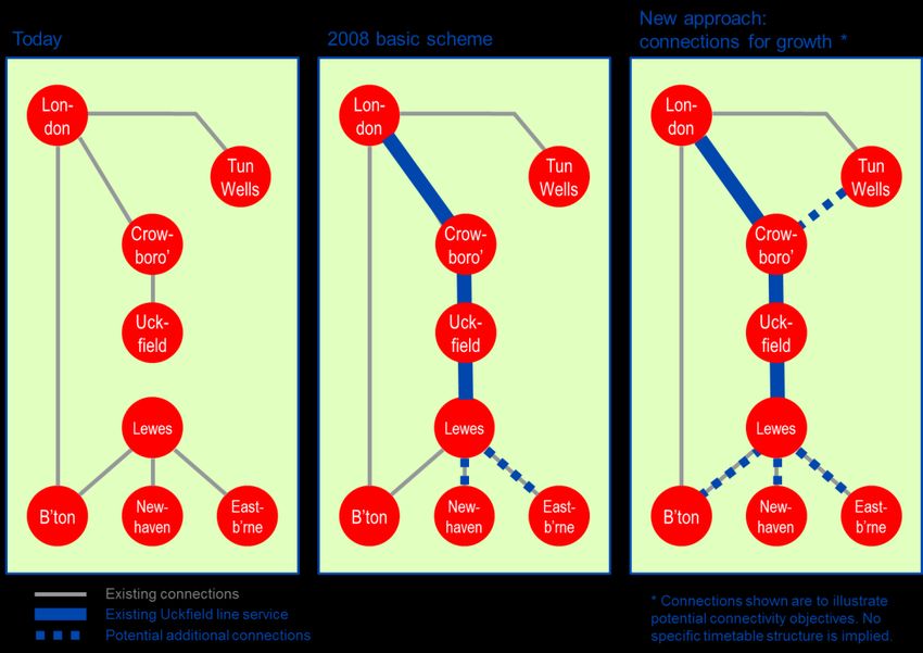
6 LEWES-UCKFIELD REOPENING AND THE TUNBRIDGE
WELLS LINK ..............................................................................29
6.1 THE PROPOSALS: LEWES-UCKFIELD LINE ............................................... 29
6.2 OUR ASSESSMENT: LEWES-UCKFIELD LINE ............................................ 30
6.3 THE PROPOSALS: TUNBRIDGE WELLS LINK WITH THE UCKFIELD
LINE .................................................................................................................. 33
6.4 OUR ASSESSMENT: TUNBRIDGE WELLS LINK WITH THE
UCKFIELD LINE............................................................................................... 34
6.5 STAKEHOLDERS’ VIEWS .............................................................................. 37
London & South Coast Rail Corridor Study WSP | Parsons Brinckerhoff
Department for Transport Project No PPRO 4-92-157 / 3511970BN
April 2016iv
6.6 RECOMMENDED WAY FORWARD................................................................ 38
7 NEW LINES ................................................................................44
7.1 THE PROPOSALS: BML2 LONDON SECTION ............................................. 44
7.2 OUR ASSESSMENT: BML2 LONDON SECTION .......................................... 46
7.3 OTHER NEW LINE SCHEMES ........................................................................ 49
7.4 RECOMMENDED WAY FORWARD................................................................ 50
8 OTHER SCHEMES .....................................................................54
8.1 UCKFIELD LINE REDOUBLING AND ELECTRIFICATION........................... 54
8.2 THE ARUNDEL CHORD .................................................................................. 55
9 CONCLUSIONS AND STRATEGIC PLAN.................................58
9.1 KEY CONCLUSIONS ....................................................................................... 58
9.2 STRATEGIC PLAN .......................................................................................... 58
London & South Coast Rail Corridor Study WSP | Parsons Brinckerhoff
Department for Transport Project No PPRO 4-92-157 / 3511970BN
April 20161
1 EXECUTIVE SUMMARY
The corridor connecting London and the south coast is a critical transport link for supporting the
region’s daily life and economy. Base passenger demand across the corridor is forecast to double
in the next 40 years, even if no further improvements are made beyond those already committed
in Control Period 5 (CP5, 2014-2019). But known network infrastructure constraints already
compromise the ability of its train and infrastructure operators to deliver an efficient and reliable
service for the public.
In this context we were asked to carry out a strategic study into improving rail links between
London and the south coast. This was targeted at the Brighton Main Line (BML) corridor,
upgrades to existing routes, and the ‘BML2’ proposal. We were also asked to re-assess proposals
for reopening the rail link between Lewes and Uckfield.
Our study has concluded that the key strategic priority for this corridor is to pursue Network Rail’s
upgrade proposals for the existing Brighton Main Line. Our analysis has shown that no other
proposals would deliver a similar level of improvements in similar timescales.
The early parts of Network Rail’s upgrade package should be progressed for implementation
during a window of opportunity in CP6 (2019-2024). These interventions, centred on the Croydon
area bottleneck, form the bedrock for future incremental capacity improvements that will create
50% more peak hour fast-line train paths into London. Our analysis supports Network Rail’s view
that the full upgrade package will enable expected demand to be met in the corridor for at least 30
years, and perhaps through to the late 2050s, dependent on the scale of housing development in
the corridor.
A CP6 implementation timing of Network Rail’s proposals is consistent with our demand
forecasts, but this timing is also opportunity-based. In particular, implementing the key elements
of a BML upgrade in this timescale would avoid a likely loss to redevelopment of the critical land
in the central Croydon area, which is necessary to upgrade the railway. It would also facilitate
major synergies in aligning well with Network Rail’s signalling system renewals programme, the
timescale for which is driven by asset condition.
Provided the BML upgrade package is progressed in line with the timeframes Network Rail has
indicated, our study indicates that there is no need in capacity terms to start planning for a new
line now, or to pursue the full ‘BML2’ scheme that incorporates a link between Croydon,
Lewisham, Stratford and beyond. New lines would be costly and, whilst providing benefits, do not
serve an existing strategic need. Furthermore, investment in reliability and resilience for the
corridor should be focused on BML itself, not diversionary routes via Uckfield or Arundel.
Our study has found there is a poor transport case for reopening the Lewes-Uckfield line, and for
National Rail services between Eridge and Tunbridge Wells. However, a stronger case could
potentially be built by harnessing the economic growth agenda, rather than just traditional
transport benefits. For these schemes to proceed, local authorities and Local Enterprise
Partnerships (LEPs) need to lead on determining how improved regional connections, centred on
Lewes-Uckfield, can contribute to economic growth, and how this investment can be funded.
We are grateful to the Department for Transport for commissioning this study, and wish to thank
the many stakeholders and other parties that have contributed to it.
London & South Coast Rail Corridor Study WSP | Parsons Brinckerhoff
Department for Transport Project No PPRO 4-92-157 / 3511970BN
April 20162
2 INTRODUCTION
2.1 STUDY CONTEXT
The rail corridor between London, central Sussex and the south coast – centred on the Brighton
Main Line (BML) – is a critical transport link for supporting the region’s daily life and economy. As
well as delivering workers into London and other employment centres along the route, it provides
access to Gatwick Airport and connects communities along and beyond the corridor.
Base passenger demand across the corridor is forecast to double in the next 40 years, even if no
further improvements are made to the route beyond those already committed in Control Period 5.
But known network infrastructure constraints already compromise the ability of its train and
infrastructure operators to deliver an efficient and reliable service for the public. The route
struggles to meet current demand levels and to achieve satisfactory performance, consistently
falling at the lower end of the Public Performance Measure (PPM) nationally, with a moving
annual average (MAA) of 81.6% at March 2016.
It is therefore important to understand the extent of the capacity challenges that this network will
face over the coming decades, and to explore the range of options for meeting these challenges.
In addition, there are long-standing stakeholder aspirations to improve the connectivity offered by
the region’s rail network, particularly centred on the Uckfield line and opportunities for reopening
to Lewes.
In the July 2015 Summer Budget, the Chancellor therefore announced a study to look at
improving rail links between London and the south coast. This was targeted at the BML corridor,
upgrades to existing routes, and the ‘BML2’ proposal. This study fulfils that commitment, and also
an earlier commitment in the March 2015 Budget to look again at Lewes-Uckfield reopening.
2.2 TERMS OF REFERENCE
The Terms of Reference document1 produced by the Department for Transport lists the key
questions that the study is intended to address. The questions fall within three main categories:
demand for services; proposals and their feasibility; and finally, the priorities for investment in the
short, medium and long term. The questions are listed in full in Figure 1.
The study was intended to focus on infrastructure options. We therefore have not explored rolling
stock strategies, demand management policies or other non-physical interventions, although we
recognise that in some cases these would offer perfectly valid solutions. We were not asked to
develop any new infrastructure solutions beyond those which have been proposed by
stakeholders, and were asked to use previous studies and existing evidence in our assessment
where available. As a result we have not sought to challenge existing cost estimates unless there
is good reason to do so.
1 London and South Coast Rail Corridor Study: Terms of Reference. DfT, October 2015.
https://www.gov.uk/government/uploads/system/uploads/attachment_data/file/465342/London_and_Sout
h_Coast_Corridor_Study.pdf
London & South Coast Rail Corridor Study WSP | Parsons Brinckerhoff
Department for Transport Project No PPRO 4-92-157 / 3511970BN
April 20163
Figure 1: Extract from Terms of Reference
1. What is the anticipated demand for services in the Study Area over the short, medium and long term,
based on rail industry projections, and future housing and commercial development?
2. Describe the proposed rail schemes identified by Network Rail, Transport for London, local
authorities, and Local Enterprise Partnerships that are relevant to the Study Area
3. Describe the proposed rail schemes advocated by stakeholders for entirely or largely new lines
between the South Coast and London, including concepts such as ‘BML2’.
4. What is the feasibility of the proposed rail schemes in 2 and 3 above, based on:
a. How they respond to demand, as identified in 1 above?
b. Network design factors, including interactions with other track infrastructure, the availability of
land and any tunnelling constraints?
c. Operational impacts, including journey time savings, the passenger flow effects of any new travel
paths to London terminals, and resilience benefits offered by new infrastructure in times of
perturbation to existing lines?
d. Estimated cost, as identified in any relevant work performed to date, or estimates based on the
cost of projects of a similar nature?
e. The extent to which they can be funded by private sector contributions?
5. Based on the above, what are the priorities for investment over short (5-10 years), medium (10-20
years) and long term time horizons (20+ years)?
6. What, if any, potential conflicts exist between priorities for investment in the short, medium and long
term, and how are these likely to be best resolved?
The ‘study area’, or ‘corridor’, referred to throughout the study is based on the requirements of the
Terms of Reference, where it was defined as: “the Brighton Main Line corridor and surrounding
catchment areas, as well as routes and catchment areas to the north east and south east of
Croydon that relate to the ‘BML2’ concept.” Given that the Government has yet to make a
decision about increased airport runway capacity in London and the South East, we were asked
to assume that Gatwick Airport remains in its current single runway configuration.
The study area boundary and stations and lines that are considered ‘in scope’ are shown in
Figure 2.
London & South Coast Rail Corridor Study WSP | Parsons Brinckerhoff
Department for Transport Project No PPRO 4-92-157 / 3511970BN
April 20164
Figure 2: Study area
LONDON BRIDGE
LONDON VICTORIA
Norwood Junction
Clapham Junction
East Croydon
n
d
ow
ea
sd
st
er
le
dd
nd
South Croydon
Ri
Sa
Upper Warlingham
Ta
tte
W
Purley Oaks Woldingham
Co
oo
nh
ul
dm
h e
e
am
sd
Ki
u t af
af
m
Ta
Ch
Re
ng
on
So tele
an
le
ha
dw
Co
ip
Oxted
ey
ed
te
sw
st
r
To
s
te
hy
nl
rn
or
hy
er
te
h
oo
Purley
w
am
Ke
Ca
er
th
W
ne
ad
W
d
n
Coulsdon South Hurst Green
Merstham Edenbridge Town
ge
Re
rid
ig
nb
at
Redhill Lingfield Hever
To
e
North Downs Line Kent Coast
Earlswood Dormans Cowden
Brighton Main Line (BML)
Salfords East Grinstead Ashurst
Other lines ‘in scope’
Horley Eridge
Stations omitted for clarity
Gatwick Airport Crowborough
Other lines ‘out of scope’
Three Bridges Buxted
Crawley
Balcombe
Ifield Uckfield
Faygate Haywards Heath
ge
rid
on
Littlehaven
sb
pt
e
es
d
um
ok
yn
w
Wivelsfield ick
Co
Le
Gl
Pl
Horsham
rw
Be
te
ga
le
Burgess Hill
Po
Southease
West Sussex Coast Kent Coast
via Arundel Newhaven Town
Hassocks
Falmer Newhaven Harbour Hampden Park
Preston Park Moulsecoomb
Bishopstone Eastbourne
West Sussex
Coast London Road (Brighton)
g
ea
g
g
ve
Seaford
in
in
in
S
Ho
nc
th
th
y-
BRIGHTON
or
La
-b
or
m
W
W
a
st
eh
Ea
or
Sh
London & South Coast Rail Corridor Study WSP | Parsons Brinckerhoff
Department for Transport Project No PPRO 4-92-157 / 3511970BN
April 20165
3 PROBLEM DEFINITION
3.1 ‘DO NOTHING’ DEMAND ASSESSMENT
We created a bespoke demand forecasting model to initially set out the anticipated ‘do nothing’
base demand over the study time horizon (from 2015 to 2060). This was based on an assessment
of current demand levels, informed by the LENNON ticket sales database, to which background
growth factors and an allowance for additional housing development were applied. The ‘do
nothing’ base case assumes no further interventions or enhancements will be implemented
beyond those already committed in CP5 (2014-2019). These include Thameslink Key Output 2
(KO2) and the Uckfield Line 10-car train lengthening scheme.
All of the demand and capacity modelling undertaken and reported as part of this study refers to
the morning ‘high peak hour’, i.e. arrivals into London or Brighton from 08:00 to 08:59. This
ensures that the peak flow into London or Brighton, i.e. the limiting case, is captured.
An annual background demand growth factor of 2.0% was applied across the study time horizon,
representing the average of the four demand growth scenarios presented in the London and
South East Market Study2. The Market Study scenarios are based on Passenger Demand
Forecasting Handbook (PDFH) elasticity assumptions that primarily capture the effects of GDP
and employment growth.
Planned housing growth (as the main determinant of development growth) was estimated at
between 7,900 and 10,250 new homes annually across the study area. The annual housing
targets for the district and unitary councils in the corridor are summarised in Figure 3.
Figure 3: Annual housing delivery targets for district and unitary councils in the Study Area
ANNUAL HOUSING
DISTRICT/UNITARY
TARGET SOURCE
COUNCIL
(NEW HOMES)
Adur 181 - 214 Local Plan (2014) / SHLAA (October 2014)
Arun 640 – 2,028 SHLAA (May 2012)
Brighton and Hove 565 - 596 Housing Strategy (2015) / SHLAA (June 2014)
London Plan (2014) / Five Year Supply of Deliverable Land for
Bromley 641 - 648
Housing (June 2015)
Housing Implementation Strategy (November 2014) / Housing
Crawley 308 - 333
Trajectory (September 2014)
Croydon 1,435 London Plan (2014)
2Long Term Planning Process: London and South East Market Study. Network Rail, October 2013.
http://www.networkrail.co.uk/publications/market-studies/london-and-south-east-market-study.pdf
London & South Coast Rail Corridor Study WSP | Parsons Brinckerhoff
Department for Transport Project No PPRO 4-92-157 / 3511970BN
April 20166
Eastbourne 400 Housing Strategy (2013)
Horsham 750 - 830 Position Statement (July 2015)
Lewes 376 - 490 Housing Land Supply Position (April 2015) / SHLAA (June 2014)
Mid Sussex 325 - 650 District Plan (March, 2015) / SHLAA (November 2015)
Reigate and Banstead 392 - 460 Core Strategy (July 2014) / SHLAA (December 2014)
Sevenoaks 165 Core Strategy (February 2011)
Tandridge 93 - 125 Core Strategy (October 2008) / SHLAA (March 2011)
Tonbridge and Malling 665 Local Plan (February 2015)
Local Plan (June 2010) / Site Allocations Development Plan
Tunbridge Wells 285 - 300
Document (Draft, February 2015)
Strategic Housing Market Assessment (October 2015) / SHLAA
Wealden 675 - 906
(December 2013)
TOTAL 7,894 - 10,245
Note: range represents minimum (constrained) and maximum (unconstrained) targets.
Our demand forecasts are ‘unconstrained’. This means that they do not specifically take into
account the effects of crowding on the rail network, and therefore represent the total demand for
rail travel if passengers were not put off travelling due to overcrowding. This assumption
significantly simplifies the analytical processing burden and is appropriate in a strategic study that
seeks to identify and prioritise measures that can remove capacity constraints.
Demand forecasting in this manner over such a long time horizon is complicated and in some
cases subjective. Approaches for the application of traditional exogenous demand drivers are well
defined, but overlaying development is more difficult, primarily because policy and strategy are
sometimes inconsistent over the forecast period, and because housing and transport are not
necessarily joined up centrally. It is also possible that overlaying development above traditional
background demand growth can cause double-counting. For this reason we have presented base
demand ‘without (housing) development’ and ‘with (housing) development’ separately throughout
this report. In the ‘with development’ case our analysis assumes a core scenario with total annual
housing growth delivery of 8,500 new dwellings, applied across the study time horizon.
The results of our ‘do nothing’ base demand growth analysis from 2015 to 2023, 2043 and 2060
towards London are presented in Figure 4, alongside Network Rail’s own growth estimates. Our
forecasts broadly mirror the growth ranges estimated by Network Rail in both the ‘with’ and
‘without’ development scenarios, although we accept that Network Rail’s figures have a base year
of 2011 rather than 2015 so are not directly comparable – particularly for the 2023 estimates. Our
2015 base year demand estimates align closely with Network Rail’s 2011 base year if four years
of pro-rata growth is added, even though our method of estimation is different.
London & South Coast Rail Corridor Study WSP | Parsons Brinckerhoff
Department for Transport Project No PPRO 4-92-157 / 3511970BN
April 20167
Our forecasts expect passenger demand in this corridor to have doubled from 2015 levels by the
late 2050s to late 2060s depending on whether housing development progresses as planned and
assuming no further rail interventions take place beyond the end of CP5. Clearly, if rail investment
in the corridor continues beyond the end of CP5, making rail travel more attractive, then
passenger numbers can be expected to grow at an even faster rate than the base forecasts.
Figure 4: Daily high peak hour base demand from Study Area towards London
Base year Demand increase on base year
Total Demand 2023 Forecast 2043 Forecast 2060 Forecast
Our estimate
32,600 11-15% 46-60% 90-112%
(Base year: 2015)
Network Rail estimate
27,300 a 40% b 56-74% c 74-101% d
(Base year: 2011)
Notes: a) combined 2011 peak hour passenger demand presented in London and SE Market Study 3 for
London Bridge ‘Thameslink & Sussex fast’ and London Victoria ‘Sussex Routes – fast services’.
b) Network Rail estimated high peak hour growth range over 2011-2023 horizon for service groups in (a),
presented in London and SE Market Study Figure 6.5.
c) Network Rail estimated high peak hour growth range over 2011-2043 horizon for service groups in (a),
presented in London and SE Market Study Figure 6.7.
d) Network Rail estimated growth range in (c) extrapolated to 2060 using equivalent annualised growth rates.
3.2 ‘DO NOTHING’ CAPACITY ASSESSMENT
Similarly to our base demand assessment, the London-bound base capacity assessments reflect
the ‘do nothing’ scenario, i.e. they present the maximum capacity that would remain on the
network if no further infrastructure or rolling stock interventions were made beyond those already
committed in CP5. The assessments compare future demand (‘with’ and ‘without’ development,
as defined in Section 3.1) against the capacity of rolling stock for the planned train service
specification, producing a forecast load factor for each year of the study horizon.
Figure 5 and Figure 6 show the load factor forecasts for the BML towards London for the study
horizon 2015 to 2060, while Figure 7 and Figure 8 show the same for the Uckfield line. The
colours in the Figures indicate the following:
Green ( █ ) indicates average demand is less than the average seating capacity for the link,
i.e. the average load factor is between 0% and the total seating capacity threshold. Therefore,
on average, there is enough seating for all passengers.
Amber ( █ ) indicates average demand is greater than the average seating capacity but less
than the average total capacity for the link, i.e. the average load factor is between the total
seating capacity threshold and 100%. Therefore, on average, there are passengers standing
but the number of standees does not exceed capacity.
Red ( █ ) indicates average demand is greater than the average total capacity for the link, i.e.
the average load factor is greater than 100%. Therefore, on average, demand exceeds
capacity, also known as ‘passengers in excess of capacity’ (PIXC).
Black ( █ ) indicates average load factors greater than 150%. We have selected this threshold
as a means of highlighting where crowding is particularly severe. Typically, this represents an
average crowding level of more than twice the density of standees allowed within the
standard total capacity.
3 ibid. Figures 6.5 & 6.7.
London & South Coast Rail Corridor Study WSP | Parsons Brinckerhoff
Department for Transport Project No PPRO 4-92-157 / 3511970BN
April 20168
Figure 5: BML ‘do nothing’ high peak hour load factors, without housing development
CP 6 CP 7 CP 8 CP 9 CP 10 CP 11 CP 12 CP 13
2018 - Rolling Stock CP5
(2019 - 2024) (2024 - 2029) (2029 - 2034) (2034 - 2039) (2039 - 2044) (2044 - 2049) (2049 - 2054) (2054 - 2059)
East Croydon--London ## ## ## ## ## ## ## ## ## ## ## ## ## ## ## ## ## ## ## ## ## ## ## ## ## ## ## ## ## ## ## ## ## ## ## ## ## ## ## ## ## ## ## ##
South Croydon--East Croydon ## ## ## ## ## ## ## ## ## ## ## ## ## ## ## ## ## ## ## ## ## ## ## ## ## ## ## ## ## ## ## ## ## ## ## ## ## ## ## ## ## ## ## ##
Purley Oaks--South Croydon ## ## ## ## ## ## ## ## ## ## ## ## ## ## ## ## ## ## ## ## ## ## ## ## ## ## ## ## ## ## ## ## ## ## ## ## ## ## ## ## ## ## ## ##
Purley--Purley Oaks ## ## ## ## ## ## ## ## ## ## ## ## ## ## ## ## ## ## ## ## ## ## ## ## ## ## ## ## ## ## ## ## ## ## ## ## ## ## ## ## ## ## ## ##
Coulsdon South--Purley ## ## ## ## ## ## ## ## ## ## ## ## ## ## ## ## ## ## ## ## ## ## ## ## ## ## ## ## ## ## ## ## ## ## ## ## ## ## ## ## ## ## ## ##
Merstham--Coulsdon South ## ## ## ## ## ## ## ## ## ## ## ## ## ## ## ## ## ## ## ## ## ## ## ## ## ## ## ## ## ## ## ## ## ## ## ## ## ## ## ## ## ## ## ##
Redhill--Merstham ## ## ## ## ## ## ## ## ## ## ## ## ## ## ## ## ## ## ## ## ## ## ## ## ## ## ## ## ## ## ## ## ## ## ## ## ## ## ## ## ## ## ## ##
Earlswood Surrey--Redhill ## ## ## ## ## ## ## ## ## ## ## ## ## ## ## ## ## ## ## ## ## ## ## ## ## ## ## ## ## ## ## ## ## ## ## ## ## ## ## ## ## ## ## ##
Salfords Surrey--Earlswood Surrey ## ## ## ## ## ## ## ## ## ## ## ## ## ## ## ## ## ## ## ## ## ## ## ## ## ## ## ## ## ## ## ## ## ## ## ## ## ## ## ## ## ## ## ##
Horley--Salfords Surrey ## ## ## ## ## ## ## ## ## ## ## ## ## ## ## ## ## ## ## ## ## ## ## ## ## ## ## ## ## ## ## ## ## ## ## ## ## ## ## ## ## ## ## ##
Gatwick Airport--Horley ## ## ## ## ## ## ## ## ## ## ## ## ## ## ## ## ## ## ## ## ## ## ## ## ## ## ## ## ## ## ## ## ## ## ## ## ## ## ## ## ## ## ## ##
Three Bridges--Gatwick Airport ## ## ## ## ## ## ## ## ## ## ## ## ## ## ## ## ## ## ## ## ## ## ## ## ## ## ## ## ## ## ## ## ## ## ## ## ## ## ## ## ## ## ## ##
Balcombe--Three Bridges ## ## ## ## ## ## ## ## ## ## ## ## ## ## ## ## ## ## ## ## ## ## ## ## ## ## ## ## ## ## ## ## ## ## ## ## ## ## ## ## ## ## ## ##
Haywards Heath--Balcombe ## ## ## ## ## ## ## ## ## ## ## ## ## ## ## ## ## ## ## ## ## ## ## ## ## ## ## ## ## ## ## ## ## ## ## ## ## ## ## ## ## ## ## ##
Wivelsfield--Haywards Heath ## ## ## ## ## ## ## ## ## ## ## ## ## ## ## ## ## ## ## ## ## ## ## ## ## ## ## ## ## ## ## ## ## ## ## ## ## ## ## ## ## ## ## ##
Burgess Hill--Wivelsfield ## ## ## ## ## ## ## ## ## ## ## ## ## ## ## ## ## ## ## ## ## ## ## ## ## ## ## ## ## ## ## ## ## ## ## ## ## ## ## ## ## ## ## ##
Hassocks--Burgess Hill ## ## ## ## ## ## ## ## ## ## ## ## ## ## ## ## ## ## ## ## ## ## ## ## ## ## ## ## ## ## ## ## ## ## ## ## ## ## ## ## ## ## ## ##
Preston Park--Hassocks ## ## ## ## ## ## ## ## ## ## ## ## ## ## ## ## ## ## ## ## ## ## ## ## ## ## ## ## ## ## ## ## ## ## ## ## ## ## ## ## ## ## ## ##
Brighton--Preston Park ## ## ## ## ## ## ## ## ## ## ## ## ## ## ## ## ## ## ## ## ## ## ## ## ## ## ## ## ## ## ## ## ## ## ## ## ## ## ## ## ## ## ## ##
Figure 6: BML ‘do nothing’ high peak hour load factors, with housing development
CP 6 CP 7 CP 8 CP 9 CP 10 CP 11 CP 12 CP 13
2018 - Rolling Stock CP5
(2019 - 2024) (2024 - 2029) (2029 - 2034) (2034 - 2039) (2039 - 2044) (2044 - 2049) (2049 - 2054) (2054 - 2059)
East Croydon--London ## ## ## ## ## ## ## ## ## ## ## ## ## ## ## ## ## ## ## ## ## ## ## ## ## ## ## ## ## ## ## ## ## ## ## ## ## ## ## ## ## ## ## ##
South Croydon--East Croydon ## ## ## ## ## ## ## ## ## ## ## ## ## ## ## ## ## ## ## ## ## ## ## ## ## ## ## ## ## ## ## ## ## ## ## ## ## ## ## ## ## ## ## ##
Purley Oaks--South Croydon ## ## ## ## ## ## ## ## ## ## ## ## ## ## ## ## ## ## ## ## ## ## ## ## ## ## ## ## ## ## ## ## ## ## ## ## ## ## ## ## ## ## ## ##
Purley--Purley Oaks ## ## ## ## ## ## ## ## ## ## ## ## ## ## ## ## ## ## ## ## ## ## ## ## ## ## ## ## ## ## ## ## ## ## ## ## ## ## ## ## ## ## ## ##
Coulsdon South--Purley ## ## ## ## ## ## ## ## ## ## ## ## ## ## ## ## ## ## ## ## ## ## ## ## ## ## ## ## ## ## ## ## ## ## ## ## ## ## ## ## ## ## ## ##
Merstham--Coulsdon South ## ## ## ## ## ## ## ## ## ## ## ## ## ## ## ## ## ## ## ## ## ## ## ## ## ## ## ## ## ## ## ## ## ## ## ## ## ## ## ## ## ## ## ##
Redhill--Merstham ## ## ## ## ## ## ## ## ## ## ## ## ## ## ## ## ## ## ## ## ## ## ## ## ## ## ## ## ## ## ## ## ## ## ## ## ## ## ## ## ## ## ## ##
Earlswood Surrey--Redhill ## ## ## ## ## ## ## ## ## ## ## ## ## ## ## ## ## ## ## ## ## ## ## ## ## ## ## ## ## ## ## ## ## ## ## ## ## ## ## ## ## ## ## ##
Salfords Surrey--Earlswood Surrey ## ## ## ## ## ## ## ## ## ## ## ## ## ## ## ## ## ## ## ## ## ## ## ## ## ## ## ## ## ## ## ## ## ## ## ## ## ## ## ## ## ## ## ##
Horley--Salfords Surrey ## ## ## ## ## ## ## ## ## ## ## ## ## ## ## ## ## ## ## ## ## ## ## ## ## ## ## ## ## ## ## ## ## ## ## ## ## ## ## ## ## ## ## ##
Gatwick Airport--Horley ## ## ## ## ## ## ## ## ## ## ## ## ## ## ## ## ## ## ## ## ## ## ## ## ## ## ## ## ## ## ## ## ## ## ## ## ## ## ## ## ## ## ## ##
Three Bridges--Gatwick Airport ## ## ## ## ## ## ## ## ## ## ## ## ## ## ## ## ## ## ## ## ## ## ## ## ## ## ## ## ## ## ## ## ## ## ## ## ## ## ## ## ## ## ## ##
Balcombe--Three Bridges ## ## ## ## ## ## ## ## ## ## ## ## ## ## ## ## ## ## ## ## ## ## ## ## ## ## ## ## ## ## ## ## ## ## ## ## ## ## ## ## ## ## ## ##
Haywards Heath--Balcombe ## ## ## ## ## ## ## ## ## ## ## ## ## ## ## ## ## ## ## ## ## ## ## ## ## ## ## ## ## ## ## ## ## ## ## ## ## ## ## ## ## ## ## ##
Wivelsfield--Haywards Heath ## ## ## ## ## ## ## ## ## ## ## ## ## ## ## ## ## ## ## ## ## ## ## ## ## ## ## ## ## ## ## ## ## ## ## ## ## ## ## ## ## ## ## ##
Burgess Hill--Wivelsfield ## ## ## ## ## ## ## ## ## ## ## ## ## ## ## ## ## ## ## ## ## ## ## ## ## ## ## ## ## ## ## ## ## ## ## ## ## ## ## ## ## ## ## ##
Hassocks--Burgess Hill ## ## ## ## ## ## ## ## ## ## ## ## ## ## ## ## ## ## ## ## ## ## ## ## ## ## ## ## ## ## ## ## ## ## ## ## ## ## ## ## ## ## ## ##
Preston Park--Hassocks ## ## ## ## ## ## ## ## ## ## ## ## ## ## ## ## ## ## ## ## ## ## ## ## ## ## ## ## ## ## ## ## ## ## ## ## ## ## ## ## ## ## ## ##
Brighton--Preston Park ## ## ## ## ## ## ## ## ## ## ## ## ## ## ## ## ## ## ## ## ## ## ## ## ## ## ## ## ## ## ## ## ## ## ## ## ## ## ## ## ## ## ## ##
Figure 7: Uckfield line ‘do nothing’ high peak hour load factors, without housing development
CP 6 CP 7 CP 8 CP 9 CP 10 CP 11 CP 12 CP 13
2018 - Thameslink CP5
(2019 - 2024) (2024 - 2029) (2029 - 2034) (2034 - 2039) (2039 - 2044) (2044 - 2049) (2049 - 2054) (2054 - 2059)
East Croydon--London ## ## ## ## ## ## ## ## ## ## ## ## ## ## ## ## ## ## ## ## ## ## ## ## ## ## ## ## ## ## ## ## ## ## ## ## ## ## ## ## ## ## ## ##
South Croydon--East Croydon ## ## ## ## ## ## ## ## ## ## ## ## ## ## ## ## ## ## ## ## ## ## ## ## ## ## ## ## ## ## ## ## ## ## ## ## ## ## ## ## ## ## ## ##
Sanderstead--South Croydon ## ## ## ## ## ## ## ## ## ## ## ## ## ## ## ## ## ## ## ## ## ## ## ## ## ## ## ## ## ## ## ## ## ## ## ## ## ## ## ## ## ## ## ##
Riddlesdown--Sanderstead ## ## ## ## ## ## ## ## ## ## ## ## ## ## ## ## ## ## ## ## ## ## ## ## ## ## ## ## ## ## ## ## ## ## ## ## ## ## ## ## ## ## ## ##
Upper Warlingham--Riddlesdown ## ## ## ## ## ## ## ## ## ## ## ## ## ## ## ## ## ## ## ## ## ## ## ## ## ## ## ## ## ## ## ## ## ## ## ## ## ## ## ## ## ## ## ##
Woldingham--Upper Warlingham ## ## ## ## ## ## ## ## ## ## ## ## ## ## ## ## ## ## ## ## ## ## ## ## ## ## ## ## ## ## ## ## ## ## ## ## ## ## ## ## ## ## ## ##
Oxted--Woldingham ## ## ## ## ## ## ## ## ## ## ## ## ## ## ## ## ## ## ## ## ## ## ## ## ## ## ## ## ## ## ## ## ## ## ## ## ## ## ## ## ## ## ## ##
Hurst Green--Oxted ## ## ## ## ## ## ## ## ## ## ## ## ## ## ## ## ## ## ## ## ## ## ## ## ## ## ## ## ## ## ## ## ## ## ## ## ## ## ## ## ## ## ## ##
Edenbridge Town--Hurst Green ## ## ## ## ## ## ## ## ## ## ## ## ## ## ## ## ## ## ## ## ## ## ## ## ## ## ## ## ## ## ## ## ## ## ## ## ## ## ## ## ## ## ## ##
Hever--Edenbridge Town ## ## ## ## ## ## ## ## ## ## ## ## ## ## ## ## ## ## ## ## ## ## ## ## ## ## ## ## ## ## ## ## ## ## ## ## ## ## ## ## ## ## ## ##
Cowden Kent--Hever ## ## ## ## ## ## ## ## ## ## ## ## ## ## ## ## ## ## ## ## ## ## ## ## ## ## ## ## ## ## ## ## ## ## ## ## ## ## ## ## ## ## ## ##
Ashurst--Cowden Kent ## ## ## ## ## ## ## ## ## ## ## ## ## ## ## ## ## ## ## ## ## ## ## ## ## ## ## ## ## ## ## ## ## ## ## ## ## ## ## ## ## ## ## ##
Eridge--Ashurst ## ## ## ## ## ## ## ## ## ## ## ## ## ## ## ## ## ## ## ## ## ## ## ## ## ## ## ## ## ## ## ## ## ## ## ## ## ## ## ## ## ## ## ##
Crowborough--Eridge ## ## ## ## ## ## ## ## ## ## ## ## ## ## ## ## ## ## ## ## ## ## ## ## ## ## ## ## ## ## ## ## ## ## ## ## ## ## ## ## ## ## ## ##
Buxted--Crowborough ## ## ## ## ## ## ## ## ## ## ## ## ## ## ## ## ## ## ## ## ## ## ## ## ## ## ## ## ## ## ## ## ## ## ## ## ## ## ## ## ## ## ## ##
Uckfield--Buxted ## ## ## ## ## ## ## ## ## ## ## ## ## ## ## ## ## ## ## ## ## ## ## ## ## ## ## ## ## ## ## ## ## ## ## ## ## ## ## ## ## ## ## ##
Figure 8: Uckfield line ‘do nothing’ high peak hour load factors, with housing development
CP 6 CP 7 CP 8 CP 9 CP 10 CP 11 CP 12 CP 13
2018 - Thameslink CP5
(2019 - 2024) (2024 - 2029) (2029 - 2034) (2034 - 2039) (2039 - 2044) (2044 - 2049) (2049 - 2054) (2054 - 2059)
East Croydon--London ## ## ## ## ## ## ## ## ## ## ## ## ## ## ## ## ## ## ## ## ## ## ## ## ## ## ## ## ## ## ## ## ## ## ## ## ## ## ## ## ## ## ## ##
South Croydon--East Croydon ## ## ## ## ## ## ## ## ## ## ## ## ## ## ## ## ## ## ## ## ## ## ## ## ## ## ## ## ## ## ## ## ## ## ## ## ## ## ## ## ## ## ## ##
Sanderstead--South Croydon ## ## ## ## ## ## ## ## ## ## ## ## ## ## ## ## ## ## ## ## ## ## ## ## ## ## ## ## ## ## ## ## ## ## ## ## ## ## ## ## ## ## ## ##
Riddlesdown--Sanderstead ## ## ## ## ## ## ## ## ## ## ## ## ## ## ## ## ## ## ## ## ## ## ## ## ## ## ## ## ## ## ## ## ## ## ## ## ## ## ## ## ## ## ## ##
Upper Warlingham--Riddlesdown ## ## ## ## ## ## ## ## ## ## ## ## ## ## ## ## ## ## ## ## ## ## ## ## ## ## ## ## ## ## ## ## ## ## ## ## ## ## ## ## ## ## ## ##
Woldingham--Upper Warlingham ## ## ## ## ## ## ## ## ## ## ## ## ## ## ## ## ## ## ## ## ## ## ## ## ## ## ## ## ## ## ## ## ## ## ## ## ## ## ## ## ## ## ## ##
Oxted--Woldingham ## ## ## ## ## ## ## ## ## ## ## ## ## ## ## ## ## ## ## ## ## ## ## ## ## ## ## ## ## ## ## ## ## ## ## ## ## ## ## ## ## ## ## ##
Hurst Green--Oxted ## ## ## ## ## ## ## ## ## ## ## ## ## ## ## ## ## ## ## ## ## ## ## ## ## ## ## ## ## ## ## ## ## ## ## ## ## ## ## ## ## ## ## ##
Edenbridge Town--Hurst Green ## ## ## ## ## ## ## ## ## ## ## ## ## ## ## ## ## ## ## ## ## ## ## ## ## ## ## ## ## ## ## ## ## ## ## ## ## ## ## ## ## ## ## ##
Hever--Edenbridge Town ## ## ## ## ## ## ## ## ## ## ## ## ## ## ## ## ## ## ## ## ## ## ## ## ## ## ## ## ## ## ## ## ## ## ## ## ## ## ## ## ## ## ## ##
Cowden Kent--Hever ## ## ## ## ## ## ## ## ## ## ## ## ## ## ## ## ## ## ## ## ## ## ## ## ## ## ## ## ## ## ## ## ## ## ## ## ## ## ## ## ## ## ## ##
Ashurst--Cowden Kent ## ## ## ## ## ## ## ## ## ## ## ## ## ## ## ## ## ## ## ## ## ## ## ## ## ## ## ## ## ## ## ## ## ## ## ## ## ## ## ## ## ## ## ##
Eridge--Ashurst ## ## ## ## ## ## ## ## ## ## ## ## ## ## ## ## ## ## ## ## ## ## ## ## ## ## ## ## ## ## ## ## ## ## ## ## ## ## ## ## ## ## ## ##
Crowborough--Eridge ## ## ## ## ## ## ## ## ## ## ## ## ## ## ## ## ## ## ## ## ## ## ## ## ## ## ## ## ## ## ## ## ## ## ## ## ## ## ## ## ## ## ## ##
Buxted--Crowborough ## ## ## ## ## ## ## ## ## ## ## ## ## ## ## ## ## ## ## ## ## ## ## ## ## ## ## ## ## ## ## ## ## ## ## ## ## ## ## ## ## ## ## ##
Uckfield--Buxted ## ## ## ## ## ## ## ## ## ## ## ## ## ## ## ## ## ## ## ## ## ## ## ## ## ## ## ## ## ## ## ## ## ## ## ## ## ## ## ## ## ## ## ##
London & South Coast Rail Corridor Study WSP | Parsons Brinckerhoff
Department for Transport Project No PPRO 4-92-157 / 3511970BN
April 20169
It should be noted that the definition of PIXC loading also includes passengers standing for more
than 20 minutes. Our modelling approach does not explicitly capture this, but it can be inferred
that any standing (amber, red or black colours) indicated on line sections from Brighton/Uckfield
to East Croydon is effectively longer than 20 minutes, as most passengers standing will continue
to stand from East Croydon to London, which itself is journey of around 20 minutes. Our LENNON
ticket sales analysis for the study area indicates that only 3-4% of total peak hour London-bound
passengers exit at Croydon.
It should also be noted that the capacities used in determining the load factors reflect ‘perfect’
operating conditions, achieving the planned timetable and rolling stock allocation (primarily based
on MOIRA data). The load factors therefore do not capture the variations in loading that arise
from delays, cancellations or other service disruption.
The Figures show that in 2018 seating capacity is able to fully meet unconstrained demand up to
Gatwick Airport in both scenarios for at least 10-15 years as a result of the additional capacity
released by the committed Thameslink Key Output 2 works. On the Uckfield line, the committed
10-car train lengthening scheme due for completion in CP5 already results in major crowding
alleviation, with seating capacity able to fully meet unconstrained demand on the entire branch
until at least CP9 (2034-2039). The effect of housing development on demand is significant,
causing PIXC loading thresholds to be surpassed as much as a decade earlier than the ‘without
development’ case.
Figure 9 to Figure 11 illustrate the range of load factors on the BML and Uckfield Line for three
discrete years of the study horizon: 2023, 2043 and 2060 respectively. These use the same
colour coding as the earlier load factor charts.
Figure 9: ‘Do nothing’ load factors, high peak hour, Year 2023
Without housing development With housing development
CENTRAL LONDON CENTRAL LONDON
(London Victoria / London Bridge) (London Victoria / London Bridge)
am
am
n
n
d
d
gh
gh
EAST CROYDON EAST CROYDON
ow
ow
ea
ea
lin
lin
sd
sd
st
st
ar
ar
er
er
le
le
rW
rW
nd
dd
nd
dd
South Croydon South Croydon
am
am
Sa
Ri
Sa
Ri
pe
pe
Up
Up
gh
gh
n
n
di
di
ol
Purley Oaks Purley Oaks ol
W
W
d
d
te
te
Ox
Ox
Purley Purley
Tattenham Corner Caterham Tattenham Corner Caterham
Coulsdon South Hurst Green Coulsdon South Hurst Green
East Grinstead East Grinstead
Merstham Edenbridge Town Merstham Edenbridge Town
Redhill Hever Redhill Hever
Reigate Tonbridge Reigate Tonbridge
Earlswood Cowden Earlswood Cowden
Salfords Ashurst Salfords Ashurst
Horley Eridge Horley Eridge
Gatwick Airport Crowborough Gatwick Airport Crowborough
Three Bridges Buxted Three Bridges Buxted
Arun Valley via Horsham Arun Valley via Horsham
Balcombe UCKFIELD Balcombe UCKFIELD
Haywards Heath Haywards Heath
Wivelsfield Wivelsfield
Lewes Lewes
Burgess Hill Burgess Hill
Hassocks Hassocks
Preston Park Preston Park
West Coastway via Hove East Coastway via Lewes West Coastway via Hove East Coastway via Lewes
BRIGHTON BRIGHTON
London & South Coast Rail Corridor Study WSP | Parsons Brinckerhoff
Department for Transport Project No PPRO 4-92-157 / 3511970BN
April 201610
The left-hand side of Figure 9 illustrates the average load factors on the BML and Uckfield Line
for the high peak hour in the ‘without development’ scenario, effectively combining Figure 5 and
Figure 7, but for 2023 only. This can be considered to present a lower-end estimate of load
factors, as it doesn’t allow for the additional demand that will be introduced to the network due to
new housing developments. The right-hand side of Figure 9 illustrates the load factors for the high
peak hour in the ‘with development’ scenario, effectively combining Figure 6 and Figure 8, but for
2023 only. This can be considered to present a high-end estimate of load factors, accounting for
additional demand from new housing development.
The BML (London to Brighton) elements of the Figures are directly comparable to Figure 30 in
Network Rail’s Sussex Route Study4 (‘Seat Utilisation on the BML 2023 including committed CP5
interventions’). Comparing our load factor estimates with Network Rail’s seat utilisation forecasts
for 2023, there are several key differences. Network Rail expects seating availability between
Brighton and Haywards Heath, and then between Gatwick Airport and East Croydon, with
standing between Haywards Heath and Gatwick Airport, and then from East Croydon to London.
Our estimates are slightly less favourable, indicating in both scenarios seating availability only
between Brighton and Haywards Heath. Standing from Haywards Heath to East Croydon and
beyond exceeds the 20-minute standing threshold for PIXC. On the Uckfield branch there is not
expected to be a particular capacity problem by 2023, although there is the potential need for
some passengers to stand north of Riddlesdown or Upper Warlingham.
Figure 10: ‘Do nothing’ load factors, high peak hour, Year 2043
Without housing development With housing development
4South East Route: Sussex Area Route Study. Network Rail, September 2015.
https://www.networkrail.co.uk/Sussex-Area-Route-Study-FINAL.pdf
London & South Coast Rail Corridor Study WSP | Parsons Brinckerhoff
Department for Transport Project No PPRO 4-92-157 / 3511970BN
April 201611
CENTRAL LONDON CENTRAL LONDON
(London Victoria / London Bridge) (London Victoria / London Bridge)
am
am
n
n
d
d
gh
gh
EAST CROYDON EAST CROYDON
ow
ow
ea
ea
lin
lin
sd
sd
st
st
ar
ar
er
er
le
le
rW
rW
nd
dd
nd
dd
South Croydon South Croydon
am
am
Sa
Ri
Sa
Ri
pe
pe
Up
Up
gh
gh
n
n
di
di
ol
ol
Purley Oaks Purley Oaks
W
W
d
d
te
te
Ox
Ox
Purley Purley
Tattenham Corner Caterham Tattenham Corner Caterham
Coulsdon South Hurst Green Coulsdon South Hurst Green
East Grinstead East Grinstead
Merstham Edenbridge Town Merstham Edenbridge Town
Redhill Hever Redhill Hever
Reigate Tonbridge Reigate Tonbridge
Earlswood Cowden Earlswood Cowden
Salfords Ashurst Salfords Ashurst
Horley Eridge Horley Eridge
Gatwick Airport Crowborough Gatwick Airport Crowborough
Three Bridges Buxted Three Bridges Buxted
Arun Valley via Horsham Arun Valley via Horsham
Balcombe UCKFIELD Balcombe UCKFIELD
Haywards Heath Haywards Heath
Wivelsfield Wivelsfield
Lewes Lewes
Burgess Hill Burgess Hill
Hassocks Hassocks
Preston Park Preston Park
West Coastway via Hove East Coastway via Lewes West Coastway via Hove East Coastway via Lewes
BRIGHTON BRIGHTON
The left-hand side of Figure 10 illustrates the expected load factors on the BML and Uckfield Line
for the high peak hour in the ‘without development’ scenario for 2043. As before, this can be
considered to present a lower-end estimate of load factors. The right-hand side of Figure 10
illustrates the load factors for the high peak hour in the ‘with development’ scenario for 2043,
again representing a high-end estimate of load factors.
The BML elements of the Figures are directly comparable to Figure 31 in Network Rail’s Sussex
Route Study (‘Seat utilisation on the BML 2043, with no interventions after CP5’). As before, there
are several key differences between our load factor estimates and those of Network Rail. Whilst
both estimates expect seating availability between Brighton and Preston Park, and standing on
the rest of the BML, the density of crowding differs. Network Rail expects total capacity (seats
plus standing) to be exceeded between East Croydon and London, whereas our estimate
indicates that this could occur as early as Purley Oaks or Merstham. In both cases, the need for
passengers to stand from Preston Park or Hassocks onwards to London – a journey of up to one
hour 15 minutes - would be classed as PIXC. On the Uckfield branch standing would be expected
from Crowborough onwards; also a journey of up to one hour 15 minutes.
Figure 11: ‘Do nothing’ load factors, high peak hour, Year 2060
Without housing development With housing development
London & South Coast Rail Corridor Study WSP | Parsons Brinckerhoff
Department for Transport Project No PPRO 4-92-157 / 3511970BN
April 201612
CENTRAL LONDON CENTRAL LONDON
(London Victoria / London Bridge) (London Victoria / London Bridge)
am
am
n
n
d
d
gh
gh
EAST CROYDON EAST CROYDON
ow
ow
ea
ea
lin
lin
sd
sd
st
st
ar
ar
er
er
le
le
rW
rW
nd
dd
nd
dd
South Croydon South Croydon
am
am
Sa
Ri
Sa
Ri
pe
pe
Up
Up
gh
gh
n
n
di
di
ol
ol
Purley Oaks Purley Oaks
W
W
d
d
te
te
Ox
Ox
Purley Purley
Tattenham Corner Caterham Tattenham Corner Caterham
Coulsdon South Hurst Green Coulsdon South Hurst Green
East Grinstead East Grinstead
Merstham Edenbridge Town Merstham Edenbridge Town
Redhill Hever Redhill Hever
Reigate Tonbridge Reigate Tonbridge
Earlswood Cowden Earlswood Cowden
Salfords Ashurst Salfords Ashurst
Horley Eridge Horley Eridge
Gatwick Airport Crowborough Gatwick Airport Crowborough
Three Bridges Buxted Three Bridges Buxted
Arun Valley via Horsham Arun Valley via Horsham
Balcombe UCKFIELD Balcombe UCKFIELD
Haywards Heath Haywards Heath
Wivelsfield Wivelsfield
Lewes Lewes
Burgess Hill Burgess Hill
Hassocks Hassocks
Preston Park Preston Park
West Coastway via Hove East Coastway via Lewes West Coastway via Hove East Coastway via Lewes
BRIGHTON BRIGHTON
Figure 11 illustrates the same load factor estimates, this time for 2060. Network Rail’s route study
did not look as far ahead as 2060, and therefore the diagram is not directly comparable. However,
our high-end estimate (the right-hand side of the Figure) expects standing throughout the high
peak hour on the entire BML and Uckfield Line if no further interventions are made beyond CP5.
Total capacity (seats plus standing) will be exceeded north of Haywards Heath on the BML, and
intermittently north of Crowborough. Levels of crowding between East Croydon and London
stations would on average be at least twice the permitted density in the high-end estimate.
Overall, our ‘do nothing’ capacity assessment has shown that without further interventions and
investment post-CP5 the BML (and to a lesser extent, the Uckfield Line) will see unacceptable
periods of standing as the norm and PIXC commonplace for much of the high peak hour, with
total rolling stock capacity regularly exceeded in certain locations by as soon as CP7 (2024-
2029). With the addition of rapid housing development and resulting rail demand growth, we
expect crowding to become an even more pressing issue than described in Network Rail’s
Sussex Route Study. However, our central load factor forecasts broadly align with those of
Network Rail.
London & South Coast Rail Corridor Study WSP | Parsons Brinckerhoff
Department for Transport Project No PPRO 4-92-157 / 3511970BN
April 201613
4 REVIEWING THE OPTIONS
4.1 STAKEHOLDER ENGAGEMENT
As part of the consultation element of this study we have spoken to nearly 30 stakeholder groups,
as well as receiving written representations from a smaller number of local groups and individuals.
The relatively short timescale for delivering this study meant that a full and detailed consultation
with formal submissions from all interested parties was not feasible. However, it was important to
understand the views and priorities of key groups: in particular we met with Network Rail, TfL,
GTR (the rail operator), Gatwick Airport and key local authorities and Local Enterprise
Partnerships. We also identified and met local interest groups, statutory passenger representative
groups, rail user groups and known scheme promoters for the corridor.
4.2 RAIL SCHEME PROPOSALS
The steps taken in identifying and analysing rail scheme proposals were as follows:
Gather high level information on formally proposed and advocated schemes for the corridor to
create a long-list, compiling a technical summary of the evidence for each proposal
Complete an assessment and sifting exercise (based on the DfT’s Early Assessment and
Sifting Tool (EAST) method) to eliminate options that fail to meet prioritisation criteria,
strategic aims or to respond to known capacity issues, revealing a short-list of rail schemes
Condense short-listed scheme options into realistic packages of schemes, based on
assumptions about deliverability and compatibility of individual proposals, and develop outline
service specifications for each scenario to enable demand impacts to be tested
The long-list of rail scheme proposals is provided in Figure 12. Marshlink (Ashford-Hastings)
electrification, North Downs Line (Reigate-Reading) electrification, improvements to Coastway
services to/from Brighton, and the Reigate 12-car platform were all deemed to be outside our
scope early in the study process, and therefore were not included on the long-list.
Figure 12: Long-list of rail scheme proposals and summary description
REF. SCHEME NAME SUMMARY
ARU-01 Arundel chord New chord (North to east spur at Arundel Jn) providing direct link between
Arun Valley line (via Horsham) and West Coastway (via Worthing).
BML-01 Network Rail route upgrade The key CP6 infrastructure options proposed by Network Rail are:
package – CP6 ‘core works’ 2 extra platforms at East Croydon station (to give eight in total) plus
full station reconstruction
Grade separation of Windmill Bridge Junction, Selhurst Junction and
Cottage Junction
Additional tracks between East Croydon and the Selhurst triangle, to
tie the above proposals together
Reigate new 12 car platform
Norwood Junction track layout alterations
South Croydon minor signalling improvements
BML-02 Network Rail route upgrade As BML-01 but with the addition of the key CP7 infrastructure options
package – CP7 ‘further works’ proposed by Network Rail as follows:
Keymer Junction grade separation and Wivelsfield Station rebuild
24tph at London Bridge low level, through the Digital Railway
programme
Gatwick track layout modifications (fast line capability enhancements)
Haywards Heath track layout modifications (London-end turnback
enhancements)
London & South Coast Rail Corridor Study WSP | Parsons Brinckerhoff
Department for Transport Project No PPRO 4-92-157 / 3511970BN
April 201614
REF. SCHEME NAME SUMMARY
BML-03 Network Rail route upgrade As BML-02 but with the addition of the key long term (assumed CP8 or
package – CP8+ ‘maximum beyond) infrastructure options proposed by Network Rail as follows:
capacity’ Clapham Junction remodelling
Victoria remodelling
Grade separation at Stoats Nest
Redhill south end remodelling
Three Bridges remodelling
ETCS & Traffic Management
BML-04 Partial quadruple-tracking of An additional two tracks on the existing BML between:
BML Haywards Heath and Hassocks; and
Preston Park and Brighton.
Assumes that in the remaining double-track locations, automatic train
control can provide the necessary capacity and mix of stopping and faster
trains. This avoids quadrupling the tunnels.
BML-05 Full quadruple-tracking of BML As BML-04 but extended northwards to include Balcombe Tunnel and New
south of Balcombe Tunnel Jn to Copyhold Junction. Requires additional platforms at all stations between
Brighton Balcombe and Preston Park.
LEW-01 Uckfield-Lewes reopening: Reinstatement of the former Uckfield-Lewes line, approx 12km (7.5 miles).
Facing east at Lewes (2008 South end faces east towards Lewes, using the original (1858) route via
scheme) Hamsey (or near equivalent) to meet the existing Keymer Jn-Lewes line
west of Lewes. Relocated Uckfield station with associated closure of
B21201 (High Street) to traffic.
LEW-02 Uckfield-Lewes reopening: As LEW-01, plus a turnback east of Lewes to allow Uckfield line trains to
Turnback siding(s) or loop east continue to/from Brighton. The turnback would be one of:
of Lewes LEW-02a: Turnback siding(s) east of Lewes station
LEW-02b: Turnback loop along north side of Lewes Bypass
LEW-02c: Turnback loop at Southerham Junction (in the vee where
the Eastbourne and Newhaven lines diverge)
LEW-03 Uckfield-Lewes reopening: With As LEW-01, plus:
new Ashcombe Tunnel (BML2 A new direct connection between the Uckfield-Lewes line near
Sussex Phase) Hamsey and the Lewes-Brighton line west of Lewes, requiring a
2.4km (1.5 mile) tunnel under the South Downs (Ashcombe tunnel)
and a bridge over the A27. This allows direct train services between
Brighton and the Uckfield line.
Additional platforms at Brighton, to accommodate the additional
trains.
There would still be a connection between the Uckfield line and Lewes, as
per LEW-01.
LEW-04 Uckfield-Lewes reopening: New Creates a Lewes-Uckfield route using:
corridor Isfield-Ringmer-Glynde The historic alignment from Uckfield to Isfield (approx. 3 miles)
A new alignment from Isfield via Ringmer to a west-facing junction
with the Eastbourne-Lewes line east of Glynde (approx. 7 miles).
The existing line from this new junction to Lewes (approx. 3 miles)
A potential addition is an east-facing junction at Glynde to allow Uckfield
line trains to serve Eastbourne directly.
LON-01 Croydon-Lewisham reopening: New cross-London through line from Uckfield/East Grinstead routes at
direct cross-London route to Selsdon, to Lewisham, Canary Wharf and Stratford, with onward
Canary Wharf and beyond via connections to West Anglia and/or Great Eastern main lines.
Selsdon Junction (BML2 Specifically it involves a combination of existing and disused rail corridors
London Phase, variant 1) between Selsdon and Lewisham, and a new tunnel between Lewisham
and Stratford.
LON-02 Croydon-Lewisham reopening: New cross-London through line from East Croydon to Lewisham, Canary
direct cross-London route to Wharf and Stratford, with onward connections to West Anglia and/or Great
Canary Wharf and beyond via Eastern main lines.
East Croydon (BML2 London This involves a tunnelled route under East Croydon (with an underground
Phase, variant 2) level to the station), continuing to Addiscombe, and then continuing
northwards as per LON-01.
LON-03 Croydon-Lewisham reopening: New cross-London through line from both BML and East Grinstead /
direct cross-London route to Uclfield corridors Croydon to Lewisham, Canary Wharf and Stratford, with
Canary Wharf and beyond with
London & South Coast Rail Corridor Study WSP | Parsons Brinckerhoff
Department for Transport Project No PPRO 4-92-157 / 3511970BN
April 201615
REF. SCHEME NAME SUMMARY
BML connection and 'Croydon onward connections to West Anglia and/or Great Eastern main lines. This
Gateway' station (BML2 London is as per LON-01, but with the addition of:
Phase, variant 3) A connection at Selsdon between BML (south to/from Gatwick) and
BML2 (north to/from Lewisham)
A potential ‘Croydon Gateway’ interchange station at Selsdon
LON-04 Croydon-Stratford tunnel: New Thameslink 2 route via Canary Wharf linking BML at East Croydon
Thameslink 2 longer-distance with Great Eastern and West Anglia Main Lines at Stratford, as follows:
services New cross-London tunnelled route via Docklands, avoiding Central
London, linking BML (for Gatwick, Brighton and South Coast) with
West and East Anglia routes
New underground interchange platforms at Lewisham, Canary Wharf
and Stratford
Three options for location of southern portal:
near Purley, with underground platforms at East Croydon
immediately north of East Croydon, with sixth track between South
and East Croydon (this could be grade-separated to avoid the
need for the flat junction at South Croydon)
north of Norwood Junction, with sixth track between South and
East Croydon and seventh and eighth track between East
Croydon and Cottage Junction
LON-05 Croydon-Stratford tunnel: Similar to LON-04 new Thameslink 2 but instead offers metro route via
Thameslink 2 metro route Canary Wharf linking BML at East Croydon with Overground, East and
West Anglia lines at Stratford, as follows:
New cross-London through route from Gatwick avoiding Central
London with tunnelled line from East Croydon to Addiscombe Railway
Park or between Blackhorse Lane and Woodside
New tunnelled line Lewisham - Stratford via Canary Wharf, to join
Overground and East/West Anglia lines
Double track only Elmers End-Lewisham. Bakerloo Line not extended
beyond Lewisham (as to do so would overload the Bakerloo Line
central Zone 1 section). Short distance metro services to BML
branches and Gatwick, interleaving with Hayes trains.
New underground interchange platforms at Lewisham, Canary Wharf
and Stratford
Three options for location of southern portal:
near Purley, with underground platforms at East Croydon
immediately north of East Croydon, with sixth track between South
and East Croydon (this could be grade-separated to avoid the
need for the flat junction at South Croydon)
north of Norwood Junction, with sixth track between South and
East Croydon, seventh and eighth track between East Croydon
and Cottage Junction, and northern portal between Clock House
and New Beckenham
NEW-01 Entirely new ‘high speed’ BML New high speed railway, mainly in tunnel, between Brighton and London.
to London Victoria Potentially three tracks, to allow 24/7 operation with one track undergoing
maintenance. Automatic operation. Timetable philosophy to combine many
short trains into long trains, to provide high frequencies without fighting for
scarce paths. Train portions attach and detach without stopping. 50 miles
(26 miles 3 track) in total, 30 miles (20 miles 3 track) in tunnels, 2 miles on
viaduct, 2
new stations plus rebuild Victoria and Brighton.
NEW-02 Entirely new ‘high speed’ BML As per NEW-01, but with new central London underground station instead
to new central London station of rebuilding Victoria. Option to link with Great Western Main Line and/or
HS2.
NEW-03 BML2 (full proposal Full BML2 proposal, consisting of:
incorporating Sussex, Kent and Sussex Phase:
London Phases) Lewes-Uckfield reopening. At the south end there would be an
east-facing connection towards Lewes station (see LEW-01 for full
details), and a west-facing connection towards Brighton with a new
tunnel under the South Downs (see LEW-03 for full details). Note:
BML2 does not propose any intermediate stations between Lewes
and Uckfield
Additional platforms at Brighton (see LEW-03 for full details)
Uckfield branch upgraded as a re-doubled, electrified 100mph
railway
London & South Coast Rail Corridor Study WSP | Parsons Brinckerhoff
Department for Transport Project No PPRO 4-92-157 / 3511970BN
April 2016You can also read