Comprehensive Outdoor Recreation Plan 2016 2021 - Adopted October 3, 2016

Page created by Lloyd Gordon
 
CONTINUE READING
Comprehensive Outdoor Recreation Plan 2016 2021 - Adopted October 3, 2016
Comprehensive Outdoor
   Recreation Plan
     2016 - 2021
    Adopted October 3, 2016
Comprehensive Outdoor Recreation Plan 2016 2021 - Adopted October 3, 2016
Acknowledgements

Village of Weston Board of Trustees                          Village Plan Commission
Barb Ermeling, President                                     Loren White, Chair
Scott Berger                                                 Fred Schuster, Vice Chair
Fred Schuster                                                Dave Diesen
Jon Ziegler                                                  Tina Kollmansberger
Loren White                                                  Marty Johnson
Mark Porlier                                                 Dennis Lawrence
Kevin Ostrowski                                              Hooshang Zeyghami
Sharon Jaeger, former Trustee                                Mike Stenstrom, former member
Karen Schmutlzer, former Trustee

Village Parks & Recreation Committee                         Planning Consultant
Kevin Ostrowski, Chair                                       MDRoffers Consulting LLC
Scott Berger                                                 4324 Upland Drive
Roger Esker                                                  Madison, WI 53705
                                                             (608) 770-0338
Lindsey Lewitzke                                             www.mdroffers.com
Kartrina Clark
Sharon Jaeger, former member
Joe Abt, former member
Tina Kollmansberger, former member

Village Staff                                                Village of Weston
Daniel Guild, Village Administrator                          5500 Schofield Avenue
Jennifer Higgins, Director of Planning & Development         Weston, WI 54476
Shawn Osterbrink, Dir. of Parks, Recreation and Forestry     (715) 359-6114
Keith Donner, Director of Public Works                       http://westonwi.gov/
Michael Wodalski, Deputy Director of Public Works
Nathan Crowe, Director of Technology Services
Scott Tatro, Building Inspector
Valerie Parker, Planning Technician
Jared Wehner, Assistant Planner

                              CONDITIONS AND ISSUES VOLUME             AMENDED: OCTOBER 3, 2016
                                   COMPREHENSIVE PLAN                                   PAGE 2
Comprehensive Outdoor Recreation Plan 2016 2021 - Adopted October 3, 2016
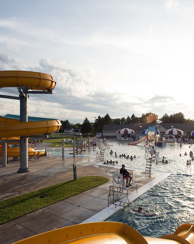
Chapter 9: Parks and Recreation
Overview
                                                                 Parks and Recreation Summary
As of 2015, the village owns 315 acres of active use
areas, passive use areas, and conservancy areas. (This          •   Combined with the Parks and
does not include the Prohaska property, acquired in                 Recreation chapter in the Vision
2016.) Village parklands are spread throughout the                  and Directions volume, this
village. The main community park (J.F. Kennedy) is                  chapter meets WIDNR
located in the older, more heavily urbanized western                requirements for a
section of the community.                                           comprehensive outdoor
                                                                    recreation plan.
The D.C. Everest School District owns and maintains
four developed outdoor recreation areas adjacent to             •   The village’s park and
schools and one school forest that adds to the village’s            recreational system features
recreation base. These recreation areas are available for           larger community parks and
use by Village residents during non-school hours. The               trails providing and array of
school recreation facilities account for approximately              amenities and activities.
131 additional acres of active use area, plus the 48-acre
                                                                •   The D.C. Everest School District,
school forest. The active use areas are mostly located in
                                                                    Marathon County, and private
the older, more heavily urbanized section of the
                                                                    providers are important
community. The two largest and most intensively
                                                                    contributors to the recreational
developed school recreation areas, D.C. Everest High
                                                                    land and facility base in
School and D.C. Everest Jr. High School, are both located
                                                                    Weston.
within one-quarter mile of Kennedy Park.
                                                                 • The village technically has an
There are several privately owned and managed
                                                                      adequate supply of park
recreation areas that contribute to the village’s
                                                                      acreage, though that does not
recreation base. These facilities are open to the public,
                                                                      necessarily reflect actual and
and provide the same opportunities as a public park or
                                                                      emerging demand for
recreation area. For the purposes of this chapter, the
                                                                      recreational activities.
private recreation area acreages are not included in the
Village Park acreage totals, but privately owned
recreation facilities are included in the village recreation facility totals.

Finally, within Marathon County there are several significant state and county parks, trails, and
recreation areas. Although they are outside of the Village of Weston they provide unique or
exceptional recreational opportunities to community residents. These areas are not included in the
acreage or facility analysis, but are included in the overall analysis because they are readily
accessible to Village residents. These facilities provide Village residents with needed and desired
facilities that are not feasible or suitable for the Village to provide.

                                 CONDITIONS AND ISSUES VOLUME                 AMENDED: OCTOBER 3, 2016
                                      COMPREHENSIVE PLAN                                         PAGE 41
Comprehensive Outdoor Recreation Plan 2016 2021 - Adopted October 3, 2016
Village Parks
The following is an inventory of the Village’s park system. Individual park maps are included in the
Parks and Recreation chapter of the Vision and Directions volume of this Comprehensive Plan.

J.F. Kennedy Park
Kennedy Park is a 38.8-acre community park that is located in the older developed section of the
Village. It is the most developed and heavily used park in the park system. It has a wide variety of
active use, passive use, and support facilities that provide residents with year-round opportunities.
The park is situated roughly on one city block and is bounded on all four sides by local streets
(Jelinek Ave. on the South, Alderson St. on the East, Alta Verde St. on the West and Neupert Ave. on
the North).

Kennedy Park is home to the Village’s outdoor swimming facility. The Weston Aquatic Center was
constructed in 1999 and is 13,223 square feet and has a capacity of 867 people. The facility
features a 300-foot water slide, a speed slide, a large drop slide that dumps into the deep end of the
pool, zero-depth entry, a one meter diving board, lap swimming lanes, water play structures, a
children’s sand play area, sand volleyball court, sunbathing area, bathhouse and concession area.
The facility is open every day from June through August and attracts approximately 50,000
swimmers each year.

Kennedy Park has a variety of organized athletic fields that receive heavy public use and use from
nearby D.C. Everest High School and Junior High School students. There are three baseball
diamonds: two irrigated Little League diamonds and an irrigated Babe Ruth diamond that is used
by the D.C. Everest Junior Varsity baseball team. There is a lacrosse field. There are two irrigated,
regulation sized soccer fields that are used by the D.C. Everest Youth Soccer Association, as well as
other area soccer organizations.

There is one sand volleyball court with permanent standards that receives heavy use. There are
also two horseshoe pits that also receive heavy use. Finally, there is one lighted hockey rink and
one lighted open skating rink that receive heavy seasonal use. A warming house that has restroom
facilities serves the skating rinks.

In the spring of 2008, the Village of Weston constructed an 8,000 square foot concrete skate park
located at the end of the large paved parking lot on the east side of the park. The skate park
includes several grinding obstacles, a bowl, and a pool.

Kennedy Park also has a number of passive and support facilities that complement the active use
facilities in the park. The park has one open sided shelter building, and two freestanding
permanent restroom buildings. There are two children’s play equipment areas in the park and an
unstructured open play area. The unstructured play area is used for a variety of activities: Frisbee,
golf, kite flying, school physical education and model airplane flying. There are two small sledding
hills on a north-facing slope adjacent to a creek on the south side of the park. There are also

                                CONDITIONS AND ISSUES VOLUME               AMENDED: OCTOBER 3, 2016
                                    COMPREHENSIVE PLAN                                       PAGE 42
Comprehensive Outdoor Recreation Plan 2016 2021 - Adopted October 3, 2016
numerous picnic tables, grills and benches throughout the park. Finally, there are approximately
250 parking stalls divided among four paved parking lots and two unpaved lots in the park.

Yellowbanks Park
Yellowbanks Park is a former Marathon County Park (Sandy Beach Park) that did not meet county
park criteria. The Marathon County Parks Department transferred the ownership and maintenance
responsibilities of Yellowbanks Park to the Town of Weston in 1993, and it has become one of the
most popular parks in the Village Park System.

Yellowbanks Park is a community park that is located on the Eau Claire River, west of, and adjacent
to Camp Phillips Road, in the north-west section of the Village. Park facilities include: restrooms,
two open-sided shelters, a drinking fountain, picnic tables, grills, children’s playground equipment,
a sand volleyball court, a canoe/kayak launch, and horseshoe pits. The park also has two paved
parking lots that service each shelter.

In the fall of 2011, the Village began the relocation and construction of a new 18-hole disc golf
course located on the south bank of the Eau Claire River. A parking lot has been constructed with
the entrance off of newly expanded Camp Phillips Road. So far 11 holes have been completed, and
all 18 holes are expected to be operational in the near future. Volume 2 highlights several potential
new and reconfigured uses for Yellowbanks Park.

Kellyland Park
Kellyland Park is a 105.6-acre community park complex located near Rogan Lane and Heather
Street in the east central section of the Village. Kellyland Park, which was formerly known as Rogan
Park, is also located adjacent to, and west of, the Eau Claire River Nature Center, and is adjacent to,
and north of the Weston Dog Park. Active use facilities at Kellyland Park include an open play area,
a children’s play equipment area, a basketball court, horseshoe pits and four soccer fields that are
primarily used by the Wausau Area Home Educators. Passive recreation facilities at Kellyland Park
include an open shelter (built 1997), picnic tables, benches and grills. Support facilities include a
restroom, two unpaved parking lots and a paved parking lot that also services the Weston Dog Park.

Kellyland Park lies mostly in the floodplain of the Eau Claire River. There are 35 acres of wooded
areas and an access to the Eau Claire River through the Eau Claire River Trail. The ten-acre upland
area including the active use facilities, are near public utility mains, and are suitable for additional
development. Volume 2 includes some preliminary ideas for such development.

The Eau Claire River Trail is a 1.3-mile walking/biking trail located on the south bank of the Eau
Claire River in the east central section of the Village. The trail extends from the north end of Ryan
Street and continues northwest to access points at Brook Court and Tricia Street at the north end of
the park. The trail is an eight-foot wide granite pathway with six bridges and sections of
boardwalk. Along the trail are seven benches and two picnic areas. Residents are welcome to
donate benches and picnic tables to expand the trail facilities.

Kellyland Park also includes the 20.6-acre undeveloped area that was previously known as Callon
Park. This area is situated north of Schofield Avenue and west of the Eau Claire River in the east
                                 CONDITIONS AND ISSUES VOLUME                AMENDED: OCTOBER 3, 2016
                                     COMPREHENSIVE PLAN                                         PAGE 43
Comprehensive Outdoor Recreation Plan 2016 2021 - Adopted October 3, 2016
central section of the Village. This is a wetland area along the Eau Claire River, which provides a
scenic nature area with a large variety of wildlife living in the area.

The Weston Dog Park at Kellyland Park was developed in 2005 through the help of donations and
volunteers. It is built on the old Weston Landfill site. The park is a completely fenced in 40-acre
area and contains picnic tables, benches and a small dog exercise area. In the spring of 2012, the
Village added several beginner level dog agility course obstacles. The Dog Park not only receives
use from Weston residents, but also is a regional destination for people to let their dogs run free of
a leash. The Dog Park is maintained by the Village, along with MiTech (former CWE) and WIDNR
due to the park being located on the old landfill.

Machmueller Park
Machmueller Park is a 32.1-acre community park acquired in 2002. 13.4 acres were acquired from
the Sandy Lane subdivision developers, John and Forrest Tappe, through parkland dedication and
18.7-acres were purchased by the Village, with support from the Town of Weston. The park is
located in the northeastern section of the Village in a heavily developed new residential area.
Machmueller Park is the only park in this section of the Village.

Active use facilities in the park include children’s play equipment, a Little League baseball field, 3
tee ball fields, one regulation sized soccer field with bleachers, a large open play area, a 10-station
“born learning” trail for children and a ¾ mile walking path with fitness course. Passive use
facilities include an open shelter, picnic tables and grills. Support facilities include a paved road
into the park and a large paved parking lot.

The park is connected to sanitary sewer; however, it uses a combination lift station/grinder pump
for service.

Williams Park
Williams Park is a 2.5-acre neighborhood park that is located about 400 feet north of Schofield
Avenue in the central section of the Village. Williams Park has few facilities, but receives
moderately heavy use from the surrounding neighborhood. Active use facilities in the park include
a sand volleyball court, an open play area and children’s play equipment area. The park has some
picnic tables, grills, benches, and approximately seven off-street lighted parking stalls in an
unpaved lot.

Sandhill Meadows Park
Sandhill Meadows Park is a 2-acre neighborhood park that is located at the corner of Shorey
Avenue and Alderson Street in the southwest corner of the Village. It was built in 2001. Sandhill
Meadows Park is currently the only park serving the southern section of the Village. The park
offers a children’s play equipment area, soccer field, volleyball court, a basketball hoop, an open
shelter, grills, restrooms and a paved parking lot.

Robinwood Park
Robinwood Park is a 5.1-acre neighborhood park that is located south of Schofield Avenue in the
east central section of the Village. It was built in 1996 and named for the subdivision around it.
                                CONDITIONS AND ISSUES VOLUME                 AMENDED: OCTOBER 3, 2016
                                     COMPREHENSIVE PLAN                                         PAGE 44
Comprehensive Outdoor Recreation Plan 2016 2021 - Adopted October 3, 2016
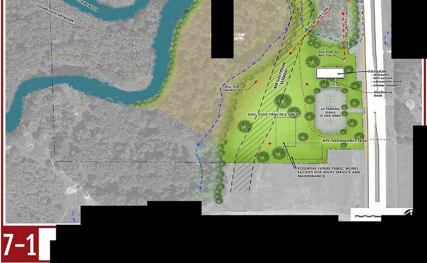
Active use facilities in the park include a Little League baseball diamond, children’s play equipment,
a basketball court and open play areas. Passive facilities include an open shelter, picnic tables, and
grills. Support facilities include two paved parking lots and restrooms.

Dale E. Smith Waterfowl Refuge
The Business Park South is a 30-acre area that the Village acquired in 2007. The land is not
developable due to wetlands. The Village has designated this area as a conservancy area. The area
has a waterfowl pond. Passive use facilities include 17-foot observation tower and two open
shelters. All are accessible via gravel walking paths off of Progress Way. Crane Meadows Golf
Course is located 1/8 of a mile from the Waterfowl Refuge.

Prohaska Family Nature Center
The Village in 2016 acquired approximately 90 acre parcel east of Ryan Street and north of and
Weston Avenue, most of which has been known as the Prohaska Tree Farm. This property is
wooded and has six ponds. Ideas for this site are put forward in Volume 2.

Undeveloped Lands
The Village in 2016 acquired additional lands south of Highway 29 near Zinser Street that are
suitable for sports field use. Ideas for a “Regional Sports Complex” are included in Volume 2.

Other Village of Weston Multi-Use Paths
The Village of Weston is currently working with neighboring communities to create an inter-
municipality trail system. This trail system will give constituents the opportunity to safely move
between communities on designated paths.

Aside from the Eau Claire River Trail, described above, the Village of Weston has an asphalt multi-
use path along Camp Phillips Road from the northern edge of the Village at Northwestern Avenue,
which connects the Village to the City of Wausau and to the southern edge of the Village, which
connects to the Village of Kronenwetter. There is also a concrete multi-use path along Weston
Avenue to the west, which services the St. Clare’s Hospital area. Opened in late 2011 was a
pedestrian bridge across Highway 29 at Birch Street. A multi-use path was also extended south on
Birch to Weston Avenue. Added during the Ross Avenue reconstruction in 2010 was a bike
lane/multi-use path. The path runs from the western edge of the Village, connecting with Schofield,
and runs to the east out as far as River Bend Road. This bike/multi-use path also runs a few blocks
away from the Eau Claire River Trail.

                                CONDITIONS AND ISSUES VOLUME               AMENDED: OCTOBER 3, 2016
                                    COMPREHENSIVE PLAN                                       PAGE 45
Comprehensive Outdoor Recreation Plan 2016 2021 - Adopted October 3, 2016
9-1
                                                                                                                                                                                                                                                                                                Village of Weston
                                                                                                                                                                                                              Kersten Rd

                                                                                                                                                                                                                                                                                               Comprehensive Plan
                                                                                      er   n Ave
                                                                             Northwest

                                                                                                                                                                                    Machmueller

                                                                                                                                                                                                                                                                                               Existing Park and Recreation Facilities
                                                                                                                                                                                       Park

                                                                                                                                              Sandy Ln
                                                                                         Yellowbanks
                                                                                             Park

                                                                                                                                                                                                                                                                                                                            Map Data Date: 3/24/2015

                                                                                                                                                                                                  Kramer Ln
                                                                                                                                                                                                                                                                                                        I
                                                                                                                                                                                                                                                                                                                           Map Adoption Date: 10/3/16
                                                                                                                                                                             Ross Ave
                                                                                                                                                                                                                                                                                                                      Created by the Village of Weston
                                                                                                                                                                                                                                                                                                                           Tech. Services Department

                                                                     Eau Claire Ave                                                                                                                                                                       Gusman Rd

                                                                                                                                                                                                                                                                       J
                                                                                                                                                                                                                                                                      Rd
                                                                                                                                                                                                                                                                                                  0    0.25     0.5                 1 Miles

                                                                                                                                                                                                                                                                      Co
                                     Alderson Ave

                                                                                               Sternberg Ave

                                                                                                                                Mesker St
                                                                                                                                                                Kellyland
                                                                                                                                                              Community Park

                                                                                                                                                         Fu
                                                                                                               Williams
             y 51

                                                                                                                                                            lle
                                                                                                                 Park

                                                                                                                                                                                                                                                                                 Rd

                                                                                                                                                               r
                                                                                                                                                                                                                                                                           River
             e Hw

                                                                                                                                                            St
         Stat

                                  Kennedy
                                    Park
                                                      Jelinek Ave                                                             E Jelinek Ave

                                                                                                                                                                                                                                                                                                 Legend
                                                                                                               Von Kanel St
                                                                                                                                                                                                                                  Schofi
                                                                                                                                                                                                                                           eld Av
                                                                                                                                                                                                                                                 e
                                                                    Birch St

                                                                                                                                                                                                                                                                                  Ringle Ave
                                                                                                                                                                   Robinwood Park

                                                    State Hwy 29                                                                                                                                                                                                                                              Mountain Bay Trail

                                                                                                                                                                                                                                                                                                              Eau Claire River Trail

                                                                                                                                                                                                                                                                                                              Surface Water
                                                                                                                                                                                                                                             Dale E. Smith
                                                                                                                                                                                                              Weston Ave                    Waterfowl Refuge
Volkman St

                                                                                                                                                                                                                                                                                                              Public Parks
                                                                     Birch St

                                                                                                                                                                                                                      Zinser St
                                                                                                                                                                                Ryan St
     Military Rd
                                                                                                                                 Heeren St
                    Margaret St

                                                                                                                                              Shorey Ave
                                   Sandhill
                                   Meadows
                                     Park

                                                      Howland Ave
                                                                      Camp Phillips Rd
Comprehensive Outdoor Recreation Plan 2016 2021 - Adopted October 3, 2016
School Recreation Areas
The following is an inventory of recreational areas owned, provided, operated, and maintained by
the D. C. Everest School District. These are open to the public during non-school hours or when
otherwise not being used for school-related purposes.

D.C. Everest Senior High School
D.C. Everest High School is located at the corner of Jelinek Avenue and Alderson Street, due south of
J. F. Kennedy Park. The high school site includes a 34-acre recreation area, which functions as a
neighborhood park. It contains eight tennis courts, two sand volleyball courts, two softball fields, a
baseball diamond and an open play area. Primarily the high school teams use the baseball and
softball diamonds, which includes bleachers, dugouts, batting cages, and pitcher’s warm-up areas.
The tennis courts, volleyball courts, and open play area are available for use by community
residents when they are not being used for school related purposes.

D.C. Everest Middle School
D.C. Everest Middle School was opened in 2002, and is located on the corner of Schofield Avenue
and County Road J. The middle school site includes a 33.3-acre recreation area, which functions as
a neighborhood park. It includes seven soccer fields, a football field, two recreation softball fields
with backstops, dugouts and bleachers and an open play area.

D.C. Everest Junior High School
D.C. Everest Junior High School is located at the corner of Jelinek Avenue and Machmueller Street,
about one half mile west of the D.C. Everest High School. The Junior High School site includes a 34-
acre recreation area, which functions as a neighborhood park. It contains a lighted stadium with a
one-quarter mile running track and turf football field, complete track facilities, seven tennis courts,
a baseball diamond with a backstop, a football practice field with goal posts, and one soccer field.
The stadium complex was updated in 2005 from a grass surface to Sports-turf surface and is used
primarily by the high school football and track teams for interscholastic competition. This track
and field are not available to the public for use, due to their high cost of maintenance and
replacement.

D.C. Everest School ForestEau Claire River Nature Center
The Eau Claire River Nature Center is a 48-acre conservancy area located east of, and adjacent to
Kellyland Park. The nature center is operated mainly as an environmental-interpretive center for
students. The Eau Claire River Nature Center has one picnic shelter, picnic tables and grills and a
variety of hiking and interpretive trails. The Eau Claire River Trail passes through the school
property on the south side of the Eau Claire River.

Weston Elementary School
Weston Elementary School is located at the corner of Camp Phillips Road and Ross Avenue in the
central section of the Village. The school site includes a 30-acre recreation area, which functions as
a neighborhood park. It includes four soccer fields, a softball diamond (that overlaps with one
soccer field), basketball court, an open play area with two softball backstops, and a large children’s

                                CONDITIONS AND ISSUES VOLUME                AMENDED: OCTOBER 3, 2016
                                     COMPREHENSIVE PLAN                                        PAGE 47
Comprehensive Outdoor Recreation Plan 2016 2021 - Adopted October 3, 2016
play equipment area. The children’s play equipment area includes eight sets of swings, one
climbing tower, twirling bars, an obstacle course, two slides, four training bars, one beehive
climber, three tether poles, and one fireman’s climber.

The Weston Elementary School recreational area also includes a skating rink and warming house
with restrooms. The Village owns the building and has historically operated this facility. The use of
the ice rink has been discontinued, and the future of the site will be discussed.

Since the ice rink was initially funded with federal money, whatever is built in its place must be of
equal or increased value. There are restrictions on the site’s use; the site must be used by a
recreational facility and the restriction is in perpetuity.

Rudolph Education Center (REC)
The Newman Catholic School’s outdoor classroom is a 33-acre parcel of land in the Village
of Weston with diverse topography, flora, and fauna. From bottomland, flood-prone forest, marsh,
and oxbow to dry, upland and field areas, students can explore many of the biological and physical
processes that occur all over Wisconsin. Opportunities to help control invasive species and monitor
deer overgrazing provide Newman students with important immersion into real problems.
Conservation clubs at Newman Catholic High School and Middle School, elementary classes, and
Eagle Scout candidates have all provided projects to clean-up or improve the property with signs, a
bridge, a building with composting toilet, trails, and other improvements.

Greenheck Field House
The Greenheck Field House is located at the D.C. Everest High School. The facility was opened in
1997 and was built for $6 million, largely from private donations. The facility was expanded in
2012 and 2014 and currently contains over 100,000 square feet. Activities that participants can
enjoy at Greenheck and in the Village are ice-skating, hockey, basketball, volleyball, and soccer.
Greenheck also has racquetball courts, a fitness center with aerobic and strength training
equipment, and a multi-use field house. Greenheck provides a Community Services Department
that organizes outdoor recreation and youth sports programs in the community. Many of the
activities offered at Greenheck carry over to outdoor facilities in the Village of Weston.

Figure 9-1 provides a summary of Village and School District owned park facilities as of 2015.

                                CONDITIONS AND ISSUES VOLUME                AMENDED: OCTOBER 3, 2016
                                     COMPREHENSIVE PLAN                                       PAGE 48
Figure 9-1: Park Land Summary
                                          Village Parks (2015)
                  Park                                     Type                 Acres
                  Kennedy Park                             Community             38.8
                  Yellowbanks Park                         Community             52.8
                  Kellyland Park (including Dog Park)      Community            106.4
                  Machmueller Park                         Community             31.1
                  Williams Park                            Neighborhood            2.5
                  Sandhill Meadows Park                    Neighborhood             2
                  Robinwood Park                           Neighborhood            5.1
                  Dale E. Smith Waterfowl Refuge           Conservancy             30
                  Total Acreage                                                 268.7
                                        School Recreation Areas
                  D.C. Everest Senior High School          Neighborhood            34
                  D.C. Everest Junior High School          Neighborhood            34
                  D.C. Everest Middle High School          Neighborhood            33
                  Weston Elementary School                 Neighborhood            30
                  D.C. Everest School Forest               Conservancy             48
                  Rudolph Education Center                 Conservancy             33
                  Total Acreage                                                   212

Private Suppliers of Recreation Facilities in Weston
In addition to Village Parks and D.C. Everest Schools, there are several private suppliers of public
recreation facilities located within the community that meet identified needs for public recreation.
These private suppliers own and maintain softball diamonds, volleyball courts, golf courses, and
support facilities that are available for public use. These facilities are available to the public on a
non-discriminatory basis. The general public can pay a fee to use these facilities, or they can belong
to an organized team that pays a fee to use the facilities, just as if the facility was managed by the
Village of Weston Parks, Forestry & Recreation Department.

Aspirus YMCA
This YMCA is affiliated with the Woodson YMCA in Wausau and opened in 2005. This facility offers
a variety of activities, including aquatics and gymnastics programs for youth and general health and
wellness activities and facilities for all ages and abilities. Community garden space is also available.
The facility is located at the corner of Howland Avenue and Camp Phillips Road.

Crane Meadows Golf Course
Crane Meadows Golf Course is a nine-hole golf course open to the public and is located south of
State Highway 29 on the east side of the Village of Weston.

                                  CONDITIONS AND ISSUES VOLUME              AMENDED: OCTOBER 3, 2016
                                      COMPREHENSIVE PLAN                                       PAGE 49
Kelly Athletic Club
The Kelly Athletic Club is located at the corner of Ross Avenue and Felch Road. This private facility
includes a lighted softball diamond, two sand volleyball courts, four horseshoe pits and restrooms
that support several adult softball, volleyball and horseshoe leagues. Facilities are open to the
public on a user fee basis.

Wiggly Field
Wiggly Field is a private athletic field that is located south of, and adjacent to Schofield Avenue in
the western section of the Village. This private facility includes four outdoor lighted volleyball
courts, an indoor volleyball complex, and restrooms. These facilities support several volleyball
leagues that are open to the public on a user fee basis.

Antlers Archery
Antlers Archery is a pro shop that offers indoor 3-D archery, allowing for sportsmen to practice
year-round. It is located at the corner of Machmueller Street and Everest Avenue.

Weston Trap Club
Weston Trap Club offers clay target shooting. The facility has six trap fields and offers instruction,
as well as youth programs. It is located on Zinzer Street, just north of Shorey Avenue.

Gym-Sport Gymnastics
Gym-Sport Gymnastics provides private gymnastics instruction to 10,000 square foot facility offers
state-of-the-art gymnastics equipment for the instruction of all areas in gymnastics including
preschool gymnastics, recreational gymnastics, competitive girls & boys artistic gymnastics,
trampoline & tumbling and cheerleading. It offers programs for youths ages 18 months to 22 years.
It is located on Rickyval Street.

Premier Sports Academy
The Premier Sports Academy provides baseball and softball training for grade school to high school
athletes through camps and clinics. The facility is aimed at those who wish to compete at the state
and national level. It offers rentals and training for all field sports including baseball, softball,
soccer, football, lacrosse and golf. It is located on Progress Way in the Weston Business and
Technology Park-South.

Weston Lanes
Weston Lanes, the second largest bowling facility in the State of Wisconsin with 60 lanes. This
facility hosts many bowling leagues and competitions., such as the Badger State Games, the High
School State Tournament, and Men’s & Women’s National Tournaments. Weston Lanes also offers
beach volleyball leagues during the summer months. It is located on Schofield Avenue, near the
Municipal Center.

                                CONDITIONS AND ISSUES VOLUME                 AMENDED: OCTOBER 3, 2016
                                     COMPREHENSIVE PLAN                                         PAGE 50
Regional Public Recreation Facilities
Rib Mountain State Park
Rib Mountain State Park is a 1,600-acre state park located on Rib Mountain in central Marathon
County, approximately five miles west of the Village of Weston. In addition to picnic areas, trails,
and scenic overlooks, the state park leases about 400 acres to Granite Peak Ski Area, a privately
operated downhill ski resort, through a concessionaire agreement.

Marathon Park
Marathon Park is one of the county’s most popular and heavily used parks. It is a 78-acre special
use county park that is located on the west side of the City of Wausau, about five miles to the
northwest of the Village of Weston. Marathon Park is well known for being the home of the
Wisconsin Valley Fair, having a large stand of second-growth White Pine, and houses numerous
historic exposition buildings that provide area residents variety of specialized recreation facilities
that also attracts visitors from a multi-county area.

Dells of the Eau Claire Park
The Dells of the Eau Claire Park is one of the most popular parks in the region. It is a 214-acre
County Park that is located about 10 miles northeast of the Village of Weston. The park is famous
for the rock outcroppings and rapids along the Eau Claire River, which runs through the park. The
park offers a variety of active and passive recreation facilities. The Eau Claire River is dammed east
of the County Road Y bridge, and has a swimming beach and shower building. An on-site ranger
resides in the campground during the summer. A large rentable shelter is situated to the west of
the highway, north of the River. Campgrounds are provided on both sides of the highway, north of
the River.

The Dells of the Eau Claire Park provides a variety of support facilities, including restrooms, picnic
tables, grills, benches, drinking fountains, and children’s play equipment. Finally, there is an
extensive trail system throughout the park, including a section of the Marathon County Segment of
the Ice Age Trail and a marked nature trail through the state scientific area that affords access to
many natural features of the area.

Sunny Vale Park & Sunny Vale Softball Complex
This is a well-used 300-acre park located on the west side of Wausau. Popular activities at this park
include snow biking, swimming, fishing, picnicking, pond hockey, and using the model airplane
flying area called Sunnyvale RC Park. There are no lifeguards on duty at the lake; swim at your own
risk. There is a roped off swim area, 2 open shelters with grills & stationary tables, scattered grills,
changing room, picnic tables, vault toilet, water pump & 2 shelters, 2 volleyball courts (bring your
own net), hiking trail around lake, fishing pier, paved paths, dumpster, and recycling station. The
Big Rib River flows through the park however, there is no developed access provided to the river.

Within the park boundaries is the five diamond Sunny Vale Softball Complex, a 71-acre recreation
area that provides facilities for organized softball activities. The softball complex is managed by the
Wausau Area Softball Association through a contract with Marathon County. Its facilities include 5

                                CONDITIONS AND ISSUES VOLUME                AMENDED: OCTOBER 3, 2016
                                     COMPREHENSIVE PLAN                                        PAGE 51
lighted softball fields each with dugouts, bleachers, score boards, and press box, concession stand
with restrooms, centrally located parking lot, and open sided shelters. The fields and lights are
available for a fee.

Bluegill Bay Park
This park offers access to Lake Wausau on its west shore. The park has double boat launch ramp
with courtesy piers. Bluegill Bay Park is heavily used by boaters and by ice fisherman to gain access
to Lake Wausau year-round. Its north section provides a boat landing, benches, picnic area, well,
open shelter, flush toilets, walking trails, volleyball court (no net provided), dumpster, paved path.

In its south section there are two open shelters. One large open shelter (#4) can be reserved, has
no electricity and has a capacity of 75 people. There is also a picnic area, well pump, vault toilets,
volleyball court, hiking trails, horseshoe pits, dumpster, grills-scattered, play equipment, recycling
center, fishing pier, limited parking, play equipment, recycling station.

Nine-Mile County Forest Unit
The Nine-Mile County Forest Unit is a 4,894-acre County forest located in central Marathon County,
about 10 miles southwest of the Village of Weston. The unit, which has multiple timber and
recreational uses, contains seven parking lots and a variety of year-round trails, including; cross-
country ski trails, snowmobile/ATV trails, hunter/walking trails, Boy Scout hiking trails, and
mountain biking trails. The Nine Mile County Forest Unit is known in particular for hunting,
mountain biking, cross-country skiing facilities (including trails, toilets, and a year round chalet),
and the 440-acre wetland that it contains. The cross-country skiing events of the Badger State
Winter Games are held on the trails of the Nine-Mile County Forest Unit. Within the Forest Unit
boundary is the Shooting Range County Park. This park contains a variety of pistol and rifle ranges,
an archery range, a trap skeet area, and a police firing range.

Kronenwetter County Forest Unit
The Kronenwetter County Forest Unit is a 5,075-acre County forest located in southeast Marathon
County, about five miles south of the Village of Weston. The Unit, which has multiple timber and
recreational uses, contains five parking lots, two pit toilets, and a variety of year-round trails,
including; six and one-half miles of the Ice Age Trail, snowmobile/ATV trails, equestrian trails,
hunter/walking trails, and six miles of dog sled trails.

Mountain-Bay State Park Trail
The Mountain-Bay State Park Trail is an 83-mile trail running from the Village of Weston in
Marathon County, passing through Shawano County and ending in the Village of Howard in Brown
County. The trail right-of-way, the former Chicago Northwestern Railroad right-of-way, is owned
by the Wisconsin Department of Natural Resources (WIDNR) except the western 3.5 miles, which is
owned by the Village of Weston. The respective counties through which the trail passes are
responsible for operation and maintenance of the trail. Marathon County manages approximately
17 miles of the Mountain-Bay Trail from within the County boundaries. The trail consists of a
crushed stone trail tread placed over existing railroad ballast. Allowed uses of the trail in
Marathon County include bicycling and hiking during non-snow cover periods and ATV and

                                CONDITIONS AND ISSUES VOLUME                AMENDED: OCTOBER 3, 2016
                                     COMPREHENSIVE PLAN                                       PAGE 52
snowmobiling during snow cover periods. The Village of Weston is the trailhead on the west end of
the trail and provides a parking area, restrooms, drinking water, and rest area.

Village of Weston Recreation Issues
Trail System Development
One of the highest priorities identified in the Statewide Comprehensive Outdoor Recreation Plan
(SCORP) is the need for more facilities to accommodate walking, jogging, and bicycling. The Village
continues to develop an overall trail system to interconnect the community and other local and
regional trail systems through a series of on-road bicycle lanes and off-road multiuse paths. These
trails have been planned to link with the trails of adjacent communities. In 2013, the Wausau MPO
worked with communities of the Wausau Metro area to establish an interconnected system of bike
routes, utilizing suitable roadways and already existing paths. The MPO has plans to expand this
network in coming years and has benefitted from timely grant support and community-wide
enthusiasm for the trail network. This system utilizes the bike and pedestrian bridge over State
Highway 29 at the extension of Birch Street, which was constructed in 2011. Along with that bridge
is a ten-foot walking path extending south to Weston Avenue. A ten-foot walking path was also
constructed in 2006 along with the reconstruction of County Road X (Camp Phillips Road), south of
Weston Avenue to Howland Avenue, the site of the Aspirus YMCA. County Road X, north of Ross
Avenue to Northwestern Avenue was reconstructed in 2011 with the addition of a ten-foot path.
Walking and bike access now spans from the southern edge of the Village to the northern edge of
the Village, connecting with Wausau on Northwestern Avenue.

Mini-Parks
The future development of mini-parks should be reviewed carefully. Although mini-parks provide a
place for tots to play in proximity to their homes, they are becoming less attractive to park systems
due to their high maintenance costs. However, mini-parks do have a role in the community and
many residents within existing neighborhoods as well as developers feel future mini-park
development is warranted. Their position is that mini-parks often provide an alternative to
children who might otherwise play in the streets.

Universal Design/ADA
The Americans with Disabilities Act of 1990 (ADA) is a sweeping civil rights law, intended to
eliminate discrimination against people with disabilities in all aspects of American life. ADA
includes provisions regarding employment, state and local government services, state and local
government public transit service, public accommodations provided by private entities, and
communications.

Under ADA, any unit of state or local government is prohibited from discriminating on the basis of
disability in the provision of state or local government services against an individual who, with or
without a reasonable accommodation, meets essential eligibility requirements for receipt of that
service. State and local government services are broadly interpreted to include every program,
service and activity of such an entity. A reasonable accommodation shall include but is not limited
to, the changing of rules, policies, and practices; the removal of architectural, transportation, and

                                CONDITIONS AND ISSUES VOLUME               AMENDED: OCTOBER 3, 2016
                                    COMPREHENSIVE PLAN                                       PAGE 53
communication barriers; and the provision of auxiliary aids and services. Units of local government
must conduct a self-analysis to identify discriminatory practices and barriers, and shall remove all
barriers as soon as is possible.

Using this definition, municipalities are required, under ADA to provide reasonable access to park
and recreation facilities and opportunities. Also, municipalities are required to upgrade non-
accessible facilities and opportunities to allow reasonable access to parks and other recreation
opportunities. ADA does not necessarily require that municipalities upgrade all park facilities
within their jurisdiction, only that the municipalities provide reasonable access to the park and
recreation system.

A realistic method for complying with ADA is “universal design.” Universal design is an evolving
idea, a method of looking at facilities and opportunities objectively, that results in programs,
services, and facilities that work for everyone. This is very different from providing special facilities
that highlight the differences between people.

Universal design results in equal opportunity facilities that enable all people to benefit from their
desired recreation experiences. The needs of all users are incorporated as an integral part of the
architecture, landscape design, and program. All people are welcome to use the facilities with little
or no assistance needed. This offers feelings of dignity, independence, self-reliance, and the
opportunity to socialize with other users. Mainstream participation is facilitated through careful
consideration of different physical, mental, and social needs. These human factors are matched
with the natural opportunities and limitations of a site in the design process. Success is best
portrayed by simple solutions that solve many problems and support many types of use. This “one
size fits all” approach is initially more complex during design, but results in simple but multi-
functional solutions.

Park Operations and Maintenance
The operations, maintenance, and upkeep of park and recreation facilities are an important
component of the overall community recreation experience. It is important that the Village of
Weston maintain adequate staff and budget appropriate funds to maintain their parklands.

The Village of Weston currently has a full-time Director of Parks, Recreation and Forestry, a full-
time (shared) administrative specialist, three park maintenance employees and 3-4 seasonal part-
time maintenance employees. The Director, who receives policy and program guidance from the
Weston Park and Recreation Committee, administers park and recreation department duties and
guidance on operations matters from the Village Administrator. The Parks and Recreation
Committee, in turn, receives guidance and approval on policy, procedure, and budget issues from
the Weston Village Board.

The Village of Weston owns and maintains several pieces of capital equipment necessary to
maintain Village parks. This equipment includes four riding mowers, a tractor, four pick-up trucks,
a skid-steer and other smaller equipment. Furthermore, the Director of Parks, Recreation and
Forestry and staff has access to other Village equipment, when necessary, for park maintenance.
                                CONDITIONS AND ISSUES VOLUME                 AMENDED: OCTOBER 3, 2016
                                     COMPREHENSIVE PLAN                                        PAGE 54
The Village maintains this equipment in good condition, but has a regular replacement schedule for
all capital equipment.

Recreational Needs Analysis
The number and type of parks and recreation facilities needed within a community depends on the
recreational needs and wants of the residents of the community. Identified recreation needs and
wants of community residents provides the basis for justifying funding and maintaining existing
recreational facilities. Most recreational needs and wants can be identified using the following five
methods of recreational needs analysis:

       1. Acreage Standards Comparison

       2. Service Area Standards Comparison

       3. Facility Standards Comparison

       4. Existing Quantitative Studies Review

       5. Public Input

Each method focuses on one specific element of recreation. Taken individually, they do not provide
an accurate representation of community-wide recreation needs. However, taken as a group,
recreation needs and wants can be aggregated and identified, and additional or new parks and
recreation facilities can be justified. Therefore, all five of these methods are used in combination to
determine the need for additional parks and/or recreational facilities in the Village of Weston.

Acreage Standards Comparison
The first method of evaluating a community’s recreational acreage needs is to determine the
number of people the existing system serves (or has the capacity to serve) and then compare it to
National Recreation and Park Association (NRPA) standards. This is accomplished by assigning an
acreage requirement for recreation areas per 1000 persons in the Village. A standard of 12 acres of
active use land per 1,000 residents is used as a basis for determining acreage needs. This Village
park acreage should be distributed throughout the community, so that all residential areas, age
groups, and activity needs are served in the best and most cost-efficient manner.

Utilizing the park standards above and the acreage totals for each park type (see Figure 9-1: Park
Land Summary), current parkland supply was calculated. Figure 9-2 shows the results of this
comparison. The Village in 2015 provided 21.03 total acres of parkland per 1,000 residents, or
about 9 total acres more than the recommended standard. Using the projected 2020 population of
the Village, it is also possible to project the recreational acreage needs for that time. According to
Figure 9-2. the Village will have a surplus of 133.1 acres or about 20.7 acres of parkland per 1000
residents in 2020.

                                CONDITIONS AND ISSUES VOLUME                AMENDED: OCTOBER 3, 2016
                                     COMPREHENSIVE PLAN                                       PAGE 55
Figure 9-2: Acreage Needs Compared to NRPA Standards
     Assumptions                                            2013*             2020**
     Acreage Need (12 acres/1000 population)                180.5 acres       201.2 acres
     Supply (Village Parks)                                 268.7 acres       268.7 acres
     Acreage Surplus                                        88.2 acres        67.5 acres
     *based on 2013 population of 15,045
     **based on 2020 projected population of 16,770

The Village has plans to expand and develop new parks. Some may question why this is necessary if
the Village already has a surplus of parkland based on recreational standards. Almost 100 acres of
current parkland is undeveloped or acts as a conservancy area. These places require very little to
no maintenance and often, in the case of the natural area at Kellyland Park, act as a floodplain. The
opportunities for public use at these places is limited.

Service Area Standards Comparison
The second method of evaluating a community’s parkland needs and adequacy of service is to plot
park service areas on a base map and then identify areas that are not being served. As a minimum,
residential groupings should be served by either a neighborhood park or community park facility.
To measure the adequacy of service the Weston park system provides residents within the Village,
park service areas were determined. Utilizing the park service radius criteria established by the
NRPA, park service areas were mapped for existing neighborhood and community parks (see Map
9-2).

Map 9-2 shows the concentration of Village parks within the older, more urbanized areas. Many
residents of the Village are well served by outdoor recreation facilities. However, there are several
neighborhoods that are not currently served by community or neighborhood parks. These areas
are on the fringe of the urbanized sections of the Village; primarily north of Ross Avenue, west of
Fuller Street, and southeast of Schofield Avenue.

It is important to know where future growth is likely to occur in the Village to project future
population concentrations and project future park service areas. These factors become very
important when recommending the location, type, and size of future park areas.

Village demographics suggest steady growth in the fringe areas of the Village. Most of the
residential growth will likely occur on and beyond the Village’s current east side, mostly north of
State Highway 29 and north of Ross Avenue. Finally, significant residential growth is expected to
occur in the south and southeast sections of the Village. These areas include east of Camp Phillips
Road (County Road X) and south of State Highway 29. As the Village expands, future park locations
will need to be assessed.

                                   CONDITIONS AND ISSUES VOLUME            AMENDED: OCTOBER 3, 2016
                                           COMPREHENSIVE PLAN                                PAGE 56
9-2
                                                                                                                                                                                                                                                                                                                               Village of Weston
                                                                                                                                                                                                                                                                                             k
                                                                                                                                                                                                                                                                                          ee
                                                                                                                                                                                                                                                                                     Cr
                                                                                                                                                                                                                                                                                dy

State
                                                                                                                                                                                                                                                                          San

                                                                                                                                                                                                                                                                                                                              Comprehensive Plan

                                                                                                                                                                                                                                                     Lester St
                                                                                                                                                                                                                                                                 Little
                                                                               NORMAN AVE

  Hw y
                                                              WHISPERING PINE AVE

                                            LAUGHLIN ST

   51
                                                                                                                                                                                                               k
                                             LINN ST

                                                                                                                                                                                                             ee
                                  DUNN ST

                                                                                                                                                                                                                                                                                                                                Public Park Service Area for 2014
                                                                                                                                                                                                           Cr
                                                                                                                                                                                                       y
                                                                                                                                                                                                    nd
                                                                                                                                                                                               Sa
                                                                                                                                                                                         Big                                                                                                                                                                    Map Date: 3/24/2015

                                                                                                       Northwest
                                                                                                                ern Ave
                                                                                                                                                                                                                           Kersten Rd
                                                                                                                                                                                                                                                                                                                                          I             Map Adoption Date: 10/03/16
                                                                                                                                                                                                                                                                                                                                                     Created by the Village of Weston
                                                                                                                                                                                                                                                                                                                                                          Tech. Services Department

                                                                                                                      Yellow
                                                                                                                      Banks                                                                         Machmueller
                                                                                                                                                                                                                                                                                                                                 0     0.25   0.5            1 Miles

                                                                                                                                                                        Sandy Ln
                                                                                                                                                                                                       Park

                                                                                                                                                                                                               Kramer Ln
                                                                                                                       Park

                                                                                                                                                                                               Ross Ave

                                                                                                                                                                                                                                                                                                                              Legend
                                                                                                  Eau Claire Ave                                                                                                                                         Gusman Rd

                                                                                                                                                                                                                                                                                                                                     Mountain Bay Trail
            Ave

                                                                                                                                                                                                                                                                                                                                     Eau Claire River Trail
           S Grand

                                                                                                                               Weston
                                                                                                                         Sternberg Ave

                                                                                                                                                          Mesker St
                                                                                                                                                                                                                                                                                                                                     Neighborhood Park (1/4 mile radius)
                                                                                                  Birch St

                                                                                                                               School                                                Kellyland
                                                                                                                                                                                       Park

                                                                                                                                                                               Fu
                                                                                                                                                                                                                                                                                                                                     Community Park (1 mile radius)
                                                                                                                                                        Williams

                                                                                                                                                                                  lle
                                                                                                                                                                                                                                                                                                       Rd
                                                                                                                                                                                                                                                                                                 River

                                                                                                                                                                                     r
                                                                                                                                         Von Kanel St
                                                                                                                                                         Park

                                                                                                                                                                                   St
                                                                                                                                                                                                                                                                                                                                     Surface Water
                                                                   Kennedy
                                                                          Alderson Ave

                            Jelinek Ave                              Park                                                                               E Jelinek Ave

                                                                                                                                                                                                                                         Schofi
                                                                                                                                                                                                                                                  eld Av
                                                                                                                                                                                                                                                                                                                              Existing Facilities
                                                                                                                                                                                                                                                        e
                                                                                                                                                                                                                                                                                                                                     Municipal Building
                                                                                                                                                                                                                                                                                                            Ringle Ave
                                                                                                                                                                                                                                                                                                                                     Public Parks
                                                                                                                                                                               Robinwood
                                                                                                                                                                                  Park
                                                                                                                                                                                                                                                                                                                                     Privately Owned Recreational Facilities
                                                                                                                                                                                                                                                                  State Hwy 29
                                                                                                                                                                                                                                                                                                                                     Public School Recreational Facilities
                                                                                                                                                                                                                                          Weston Ave                                                                                 Village of Weston Boundary
                     Volkman St

                                                                                                                                                                                                                                                                                                                                     Other Municipalities
                                                                                                   Birch St

                                                                                                                                                                                                                             Zinser St
                                                                                                                                                                                                 Ryan St
Military Rd
                                                                                                                                                          Heeren St
                                                Margaret St

                                                                   Sandhill
                                                                   Meadows                                                                                              Shorey Ave
                                                                     Park

                                                                                         Howland Ave
                                                                                                   Camp Phillips Rd

                                                                                                                                                                                                                                                                                                                    Co Rd J
Co Rd Xx
Recreational Facility Needs
The third method of determining recreational needs in a community is to compare existing facilities
and equipment to NRPA standards. The standards suggest how many users a particular
recreational resource or facility can support each day. The NRPA standards used by the Village of
Weston are shown in Figure 9-3.

                Figure 9-3: NRPA Suggested Outdoor Facility Development Standards

                                                                             No. of Units Per
                     Recommended

                                         Recommended

                                                            Recommended

                                                                                                                             Location Notes
                                                                                                     Service Radius
                     Requirements

                                          Dimensions

                                                             Orientation
     Activity

                                                                               Population
                                            Size And
                         Space

                                                                                                                          Usually in
                                    Singles – 17’x44’                                                                       school,
                                                                                                   ¼-                     recreation
                                                         Long axis           1 per
 Badminton          1620 sq. ft.                                                                   1/2                     center or
                                                        north-south          5000
                                                                                                   mile                church facility.
                                    Doubles – 20’x44’                                                                  Safe walking or
                                                                                                                         bike access.
                                                                                                                            Same as
                  Youth: 2400-                                                                                           badminton.
                                       46-50’x84’
                   3036 sq. ft.                                                                                        Outdoor courts
                                                                                                                               in
                   High School:                                                                                         neighborhood
                                                         Long axis           1 per                 ¼-½
                   5040-7280             50’x84’                                                                      and community
                                                        north-south          5000                  mile
 Basketball           sq. ft.                                                                                            parks, plus
                                                                                                                             active
                    College:                                                                                          recreation areas
                   5600-7980             50’x94’                                                                        in other park
                     sq. ft.                                                                                               settings.
                   with 5’ unobstructed space on all
                                 sides
                                                                                                                       4-wall usually
                                                         Long axis                                                     indoor as part
                                                                                                   15-30
                                        20’x40’ –       north-south.                                                       of multi-
                  800 sq. ft. for                                                                  minut
                                    Minimum of 10’ to                        1 per                                    purpose facility.
  Handball           4-wall                                                                           e
                                      rear of 3-wall                        20,000                                     3-wall usually
                                                                                                   travel
                                     court. Minimum     Front wall at                                                 outdoor in park
                                                                                                    time
                   1000 for 3-        20’ overhead       north end.                                                        or school
                      wall              clearance                                                                           setting
                                                                            Indoor –                                        Climate
                                      Rink 85’x200’
                                                                              1 per                                       important
                                       (minimum                                                    ½-1
                   22,000 sq. ft.                         Long axis         100,000                                    consideration
                                        85’x185’)                                                   hour
 Ice Hockey          including                          north-south if     Outdoor –                                   affecting no. of
                                     Additional 5000                                               travel
                   support area                            outdoor          depends                                     units. Best as
                                      sq. ft. support                                               time
                                                                                on                                      part of multi-
                                            area
                                                                             climate                                  purpose facility.

                                    CONDITIONS AND ISSUES VOLUME                                AMENDED: OCTOBER 3, 2016
                                         COMPREHENSIVE PLAN                                                                  PAGE 58
No. of Units Per
                   Recommended

                                       Recommended

                                                            Recommended

                                                                                                                             Location Notes
                                                                                                     Service Radius
                   Requirements

                                        Dimensions

                                                             Orientation
     Activity

                                                                               Population
                                          Size And
                       Space
                                                                                                                      Best in batteries
                 Minimum of          36’x78’. 12’                                                                      of 2-4. Located
                 7,200 sq. ft.    clearance on both                                                ¼-                         in
                                                         Long axis          1 court
  Tennis         single court         sides; 21’                                                   1/2                neighborhood/c
                                                        north –south       per 2000
                 (2 acres for     clearance on both                                                mile               ommunity park
                  complex)              ends.                                                                           or adjacent to
                                                                                                                            school
                                                                                                                       Same as other
                                  30’X60’. Minimum
                 Minimum of                               Long axis          1 per                 ¼-½                 court activities
 Volleyball                       6’ clearance on all
                 4,000 sq. ft.                           north-south         5000                  mile                      (e.g.
                                         sides
                                                                                                                         badminton)
                                  Official: Baselines    Locate home
                                  – 90’ Pitching            plate to
                Official: 3.0-
                                  distance 60 ½’            pitcher
                3.85 acres
                                  foul lines – min.        throwing                                                        Part of
                minimum
                                  320’ Center field –     across sun       1 per                                       neighborhood
                                  400’+                 and batter not     5000                                          complex.
                                                                                                   ¼-½
  Baseball                                              facing it. Line    Lighted 1                                   Lighted fields
                                    Little League:                                                 mile
                                                          from home        per                                             part of
                                   Baselines -- 60',
                Little League:                          plate through      30,000                                       community
                                   Mound Distance
                   1.2 acres                                pitchers                                                     complex.
                                    46', Foul lines
                  minimum                                 mound run
                                  Min. 2000', Center
                                                          east-north-
                                  Field 200' to 250'
                                                              east.
                                                         Fall season –                                                 Usually part of
                                                           long axis                               15-30                  baseball,
                                  180’ x 300’ with a
                                                         northwest to                              minut               football, soccer
                Minimum 1.5        minimum of 6’                             1 per
Field Hockey                                              southwest.                                  e                  complex in
                   acres           clearance on all                         20,000
                                                          For longer                               travel                community
                                        sides.
                                                            periods                                 time              park or adjacent
                                                         north-south                                                   to high school.
                                                                                                   15-30
                                  160’ x 360’ with a
                                                                                                   minut
                Minimum 1.5        minimum of 6’        Same as field        1 per                                     Same as field
  Football                                                                                            e
                   acres           clearance on all       hockey.           20,000                                       hockey.
                                                                                                   travel
                                        sides.
                                                                                                    time
                                                                                                                      Number of units
                                                                                                                        depends on
                                  195’ to 225’x330’                                                                     popularity.
                                   to 360’ with a                                                                     Youth soccer on
                                                        Same as field        1 per                  1-2
  Soccer        1.7 – 2.1 acres     minimum 10’                                                                        smaller fields
                                                          hockey.           10,000                 miles
                                    clearance all                                                                       adjacent to
                                        sides.                                                                           schools or
                                                                                                                       neighborhood
                                                                                                                           parks.

                                  CONDITIONS AND ISSUES VOLUME                                  AMENDED: OCTOBER 3, 2016
                                       COMPREHENSIVE PLAN                                                                    PAGE 59
No. of Units Per
                   Recommended

                                       Recommended

                                                            Recommended

                                                                                                                             Location Notes
                                                                                                     Service Radius
                   Requirements

                                        Dimensions

                                                             Orientation
     Activity

                                                                               Population
                                          Size And
                       Space
                                                           Long axis
                                                                                                                        Part of a golf
                                                         south-west-                                  30
                                   900’x690’ wide.                                                                    course complex.
                13.5 acres for                             northeast                               minut
Golf-driving                      Add 12’ width for                          1 per                                    As separate unit
                 minimum of                               with golfer                                 es
  Range                            each additional                          50,000                                         may be
                   25 tees                                  driving                                travel
                                         tee.                                                                             privately
                                                            toward                                  time.
                                                                                                                           owned.
                                                           northeast.
                                                         Long axis in
                                                                                                                       Usually part of
                                                          sector from
                                   Overall width –                                                 15-30               high school, or
                                                        north to south
  ¼ Mile                            276’ Length –                                                  minut               in community
                                                           to north-         1 per
 Running          4.3 acres         600.02’ Track                                                     es              park complex in
                                                         west-south-        20,000
  Track                            width for 8 to 4                                                travel               combination
                                                           east with
                                     lanes is 32’.                                                  time                with football,
                                                         finish line at
                                                                                                                         soccer, etc.
                                                        northerly end.
                                    Baselines – 60 ‘,
                                  Pitching distance -                                                                       Slight
                                      46' min. 40'                            1 per                                    differences in
                                  women. Fast pitch                         5,000 (if                                 dimensions for
                  1.5 to 2.0                               Same as                                 ¼-½
  Softball                         field radius from                       also used                                  16" slow pitch.
                    acres                                  baseball                                mile
                                  home plate - 225',                       for youth                                    May also be
                                  Slow pitch -- 275'                       baseball)                                  used for youth
                                      (men), 250'                                                                         baseball.
                                       (women)
  Multiple
                                                         Long axis of
Recreation
                                                           courts
   Court                                                                     1 per                  1-2
                9, 840 sq. ft.        120’ x 80’        with primary
(basketball,                                                                10,000                 miles
                                                        use is north-
 volleyball,
                                                            south
  tennis)
                                  Well defined head
                                    maximum 10’
                                  width, maximum
                                  average grade is
                                                                           1 system
                                  5% not to exceed
   Trails            N/A                                     N/A              per                   N/A
                                    15%. Capacity
                                                                            region
                                   rural trails – 40
                                  hikers/day/mile.
                                  Urban trails – 90
                                  hikers/day/mile.

                                  CONDITIONS AND ISSUES VOLUME                                  AMENDED: OCTOBER 3, 2016
                                       COMPREHENSIVE PLAN                                                                   PAGE 60
No. of Units Per
                  Recommended

                                      Recommended

                                                           Recommended

                                                                                                                           Location Notes
                                                                                                   Service Radius
                  Requirements

                                       Dimensions

                                                            Orientation
     Activity

                                                                             Population
                                         Size And
                      Space
                                    300’ Length x
                                    Minimum 10’
                                    wide between
                                   targets. Roped
                                                                                                   30
                                    clear space on
                                                       Archer facing                             minut              Part of regional
  Archery        Minimum            sides of range                          1 per
                                                        north = or –                                es               or metro park
   Range         0.65 acres         minimum 30’,                           50,000
                                                        45 degrees.                              travel                 complex.
                                      clear space
                                                                                                  time
                                   behind targets
                                     minimum of
                                     90’x45’ with
                                        bunker.
                                    All walks and
                                  structures occur
                                    within an area
                                   approximately
                                 130’ wide by 115’
                                   deep. Minimum
                                                       Center line of
                                   cleared area is
                                                        length runs                                30
Combination                       contained within
                                                         northeast-                              minut                  Part of
 Skeet and      Minimum 30        2 superimposed                            1 per
                                                         southwest                                  es              regional/metro
Trap Field (8      acres           segments with                           50,000
                                                       with shooter                              travel              park complex
  Stations)                       100-yard radii (4
                                                           facing                                 time
                                   acres). Shot-fall
                                                         northeast.
                                   danger zone is
                                  contained within
                                  2 superimposed
                                   segments with
                                 300-yard radii (36
                                        acres).
                                                                                                                    9-hole course
                 Par 3 (18                                                                                          accommodate s
                                  Average length
                hole), 50-60                                                                                        350
                                 vary 600-2700 yd.
                   acres                                                                                            people/day. 18-
                                                                                                                    hole     course
                                                                          1/25,000                                  accommodates
                   9-hole                                                                         ½ to
                 standard,       Average length –      Majority of                                                  500-550
                                                                                                    1
                Minimum 50         2250 yards           holes on                                                    people/day.
    Golf                                                                                          hour
                   acres                               north-south                                                  Course may be
                                                                                                 travel
                                                           axis                                                     located       in
                                                                                                  time
                                                                                                                    community or
                   18-hole                                                                                          district   park,
                  standard,       Average length                                                                    and not be over
                                                                          1/50,000                                  20 miles from
                Minimum 110        6500 yards
                      A                                                                                             population
                                                                                                                    center.

                                 CONDITIONS AND ISSUES VOLUME                                 AMENDED: OCTOBER 3, 2016
                                      COMPREHENSIVE PLAN                                                                  PAGE 61
No. of Units Per
                      Recommended

                                           Recommended

                                                                Recommended

                                                                                                                                Location Notes
                                                                                                         Service Radius
                      Requirements

                                            Dimensions

                                                                 Orientation
      Activity

                                                                                   Population
                                              Size And
                          Space
                                                                                                                              Pools for
                                                                                                                               general
                                         Teaching-                                                                        community use
                                       minimum of 25                                                                          should be
                                      yards x 45’ even                                                                      planned for
                                      depth of 3 to 4 ft.        None-           1 per
                                                                                                                              teaching,
                                                            although care       20,000
                                                                                                       15 to              competitive and
                   Varies on size                           must be taken       (should
                                                                                                         30                 recreational
                    of pool and                               in siting of     accommo
  Swimming                                                                                             minut               purposes with
                    amenities.         Competitive –           lifeguard        date 3-
    Pools                                                                                                 es               enough depth
                   Usually ½ to      minimum of 25 m          stations in        5% of
                                                                                                       travel                 (3.4m) to
                    2 acre site.     x 16 m. Minimum          relation to      populatio
                                                                                                        time               accommodate
                                     of 27 square feet         afternoon         n at a
                                                                                                                             1m and 3m
                                      of water surface            sun.           time.)
                                                                                                                           diving boards.
                                       per swimmer.                                                                          Located in
                                     Ratios of 2:1 deck                                                                      community
                                         vs. water.                                                                        park or school
                                                                                                                                 site.
                                                                                                                            Should have
                                     Beach area should                                                                      sand bottom
                                      have 50 sq. ft. of                                                                     with slope
                                     land and 50 sq. ft.                                                                   maximum of 5
                                     of water per user.                                                                        % (flat
 Beach Areas            N/A          Turnover rate is 3.        N/A              N/A                    N/A                 preferable).
                                      There should be                                                                      Boating areas
                                      3-4 A supporting                                                                       completely
                                        land per A of                                                                     segregated from
                                           beach.                                                                            swimming
                                                                                                                                areas.
Source: National Recreation and Park Association (1990)

In order to project facility deficiencies, Weston’s existing facilities were compared to the NRPA
standards and assumptions previously outlined. Figures 9-4 and 9-5 summarize the current
recreation facilities within the Village. Based on these national standards, the Village of Weston has
two community-wide recreation facility deficiencies. The Village of Weston has no softball fields or
no tennis courts. However, the D.C. Everest School System provides tennis courts and softball
fields. The Village has no plans to add tennis courts, but is considering a few locations for softball
fields.

                                     CONDITIONS AND ISSUES VOLUME                                   AMENDED: OCTOBER 3, 2016
                                           COMPREHENSIVE PLAN                                                                   PAGE 62
Figure 9-4: Current Recreational Facilities, Village of Weston Owned

                                                                                                             Machmueller
                                                           Yellowbanks

                                                                                      Robinwood
                                                                          Kellyland
                                      Kennedy

                                                Williams

                                                                                                  Sandhill
                   Facility                                                                                                Total

              Ball Diamonds           3                                               1                       4             8
              Basketball Courts                                            1          1           0.5                       2.5
              Volleyball Courts       1         1           1              1                      1                         5
              Horseshoe Pits          2                     1              1                                                4
              Hockey Rinks            1                                                                                     1
              Soccer Fields           2                                    4                      1           1             8
              Softball Diamonds                                                                                             0
              Outdoor Pool            1                                                                                     1
              Tennis Courts                                                                                                 0
              Ice Skating Rink        1                                                                                     1
              Restrooms               2                     1              1          1           1           1             7
              Shelters                1                     2              1          1           1           1             7
              Play Structures         2         1           1              1          1           1           1             8

                  Figure 9-5: Village of Weston Recreational Facility Analysis
   Facility                    Total Facilities                          Current Needs                               2020 Needs
   Baseball Diamond            5                                         Adequate                                    Adequate
   Basketball Court            2.5                                       Adequate                                    Adequate
   Volleyball Courts           5                                         Adequate                                    Adequate
   Horseshoe Pits              4                                         Adequate                                    Adequate
   Hockey Rinks                1                                         Adequate                                    Adequate
   Soccer Fields               8                                         Adequate                                    Adequate
   Softball fields             1                                         2                                           3
   Outdoor Pool                1                                         Adequate                                    Adequate
   Tennis Courts               0                                         6                                           7
   Ice Skating Rink            2                                         Adequate                                    Adequate
   Restrooms                   7                                         Adequate                                    Adequate
   Shelter                     7                                         Adequate                                    Adequate
   Play Areas                  8                                         Adequate                                    Adequate
   Trail System                3                                         Adequate                                    Adequate

Existing Quantitative Studies Review
The fourth method of determining recreation needs is to use local, regional, and state quantitative
recreation studies that apply to the area. These quantitative studies are statistically defensible
surveys, polls, and other instruments that help identify user trends, needs, and wants by soliciting
user responses to uniform sets of questions. These studies are very useful since they are a good
indicator of recreation needs as perceived by recreation users.

                                   CONDITIONS AND ISSUES VOLUME                                                 AMENDED: OCTOBER 3, 2016
                                           COMPREHENSIVE PLAN                                                                      PAGE 63
You can also read