LRTP 2045 - UPDATE Danville MPO Connections to 2045 - Adopted June 11, 2020 - DANVILLE AREA TRANSPORTATION STUDY
←
→
Page content transcription
If your browser does not render page correctly, please read the page content below
LRTP 2045 - UPDATE
           Danville Area Transportation Study
           Long Range Transportation Plan Update

Danville MPO
Connections to 2045

Adopted June 11, 2020
Chapter 1- Introduction        DANVILLE AREA
                        TRANSPORTATION STUDY MEMBERS

                Technical Committee                             Policy Committee

                      Vermilion County Highway              Rickey Williams      City of Danville
   Adrian
                      Department                                (Chairman)                Mayor
   Greenwell,
                      Highway Engineer
   (Chairman)
                                                       PROXY: Logan Cronk
                      Vermilion County Highway
   Janet Payonk       Department                              Larry Baughn,    Vermilion County
                                                            (Vice-Chairman)     Board Chairman
                      City of Danville
                                                       PROXY: Craig Golden
                      Community Development
   Logan Cronk        Grants & Planning
                                                               Scott Neihart     IDOT District 5
                      Manager
                                                                                      Engineer
                      Newell Township
   Jim Wilson         Supervisor                                  Sam Cole       Danville/DATS

                      City of Danville
                      Danville Mass Transit                                    Vermilion County
   Lisa Beith                                                 Craig Golden
                      Director                                                            Board
                      Vermilion County
   Mike
                      Airport Authority
   Vadeboncoeur
   McLain, Shelley    Village of Catlin

   Amy Brown          CRIS Services, CEO

   Robert Nelson      IDOT District 5

      FHWA/FTA – Betsy Tracy (non-voting)

      IDOT District 5 – Thomas Caldwell (non-voting)
                        Brian Trygg (non-voting)

      CITY OF DANVILLE STAFF

      Sam Cole, PE - City Engineer and MPO Director

      Logan Cronk - Grants and Planning Manager

      Adam Aull - GIS Coordinator

      Alicia Gonzalez -
      Department of Public Works, Engineering, Grants and Planning Division Administrative Assistant

      Natasha Elliott - Planner I

                                                                                                    2
Chapter 1- Introduction

                    Table of Contents

Chapter 1 | Introduction – page 4
Chapter 2 | Existing Conditions – page 12
Chapter 3 | The Vision Moving Forward – page 44
Chapter 4 | 2045 Needs – page 50
Chapter 5 | Recommendations – page 59
            Appendix – page 71

                                                  3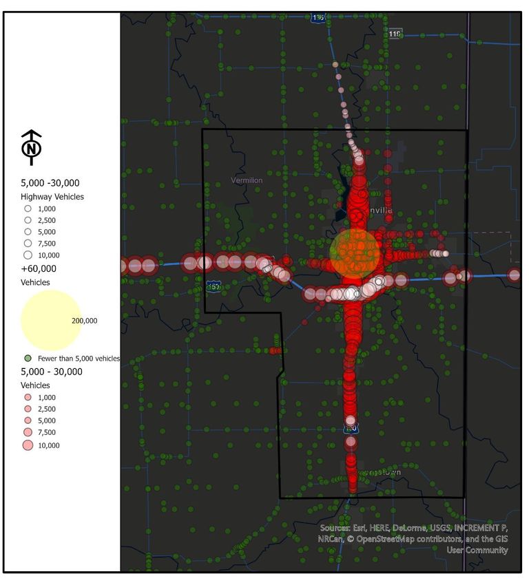
Chapter
 Chapter1-1 Introduction
            - Introduction

As a central component of daily life and something that affects everyone, transportation
represents a critical segment of our area’s social and built infrastructure. The Danville
Area Transportation Study’s 2045 Long Range Transportation Plan defines the local
strategy for creating a regional transportation system that accommodates the current
mobility needs of residents and looks to the future to anticipate where new needs may
arise. The 2045 LRTP is the largest planning effort required of the Danville Area
Transportation Study (DATS), it is also the most far-reaching. The plan fulfills federal
requirements and serves as the region’s transportation vision moving forward. It seeks
to characterize current and future transportation needs, outline the region’s long-range
transportation vision, document multi-modal transportation strategies, and identify long-
term opportunities beyond the current ability to fund projects.

Through the 2045 Long Range Transportation Plan (LRTP) process, we recognized that
the past approach for determining transportation investments did not provide an
adequate balance among modes. The 2045 LRTP sets the framework for a balanced
and forward thinking system of transportation alternatives, and stabilizes levels of
investment among these modes.

What is a Long Range Transportation Plan?

The Long Range Transportation Plan (LRTP) is a community driven process that
establishes a vision for mobility in the Danville Urbanized Area. The LRTP is an update
to the long-range vision for how the metropolitan planning area’s surface transportation
system will develop over the next 25 years. The LRTP identifies goals, needs,
investment priorities, and an implementation plan for the future transportation system.
The Plan must be developed, adopted, and updated by the Metropolitan Planning
Organization (MPO) through a process which engages the communities and all
participating agencies within the Metropolitan Planning Area (MPA).

The scope of the 2045 LRTP includes establishing goals for the region, reviewing
current plans and studies, analyzing transportation and land use conditions, engaging
stakeholders and the community, identifying multi-modal recommendations, and
developing a financially-constrained plan. The planning process was guided by DATS
Technical Committee that offered feedback throughout the plan development.

The LRTP is a forecast of future projects, given available or reasonably expected
funding, and it must be consistent with the performance-based planning standards
established in the Moving Ahead for Progress in the 21st Century Act (MAP-21).
“MPOs…in cooperation with State and public transportation operators shall develop
long-range
transportation plans and transportation improvement programs through a performance-
driven, outcome-based approach to planning.” (23 USC Section 134© (1)).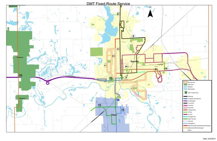
Chapter 1- Introduction

          The DATS 2045 LRTP addresses the following national planning factors:

   1. Support the economic vitality of the metropolitan area, especially by enabling global
      competitiveness, productivity & efficiency
   2. Increase the safety of the transportation system for motorized and non-motorized users
   3. Increase the security of the transportation system for motorized and non-motorized
      users
   4. Increase the accessibility and mobility of people and for freight
   5. Protect and enhance the environment, promote energy conservation, improve quality of
      life, and promote consistency between transportation improvements and State and local
      planned development patterns
   6. Enhance the integration and connectivity of the entire transportation system, across and
      between modes, for people and freight
   7. Promote efficient system management and operation
   8. Emphasize the preservation of the existing transportation system

Danville Metropolitan Planning Organization

Transportation planning in Danville and the Urbanized Area (UA) in Vermilion County is
the responsibility of the Danville Area Metropolitan Planning Organization or DATS
MPO. The MPO is a policy-making organization made up primarily of local elected
officials from each of the region’s ten member jurisdictions. Although these individuals
come to the table with multiple and sometimes conflicting perspectives, they work
together to establish local and regional priorities for the transportation improvements
that are eligible for state and federal funding.

The metropolitan transportation planning process investigates connections between
mobility, multi-modal transportation systems, environmental conditions, economic
development, and safety. DATS is responsible for conducting the 3-C planning process
in a manner that is Continuing, Cooperative, and Comprehensive.

Our Pledge

The Danville Area Transportation Study’s commitment is to move people, to create jobs
and to strengthen communities within our planning area and the surrounding region.
Through our long range planning efforts, we have made significant strides in meeting
these goals. This document builds on previous efforts by laying out a 25 year plan for
strategic transportation investments in our planning area that will improve quality of life,
maximize mobility options and promote a fiscally sustainable future.

                                                                                             5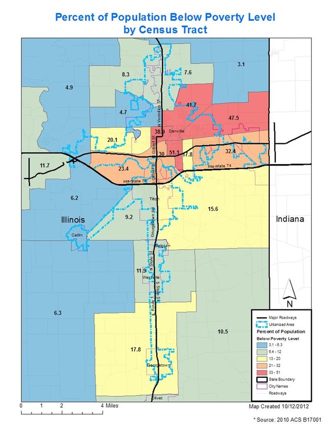
Chapter 1- Introduction
 Through outreach efforts, we know that the key to moving people is having a broad
 range of options suited to serve a range of mobility needs and economic circumstances.

 This plan will increase mobility options, including public transit, to provide our residents
 a wider variety of alternatives to driving a personal automobile for their everyday needs.
 Making the planning area more competitive in the local, regional and global economies
 is key to creating jobs.

 Our Planning Partners

 In the development of the 2045 LRTP we have sought the input of many segments of
 our communities. The outreach process intended to collect many voices and opinions
 applicable to the transportation planning process, from outreach to every day users to
 the inclusion of private sector stakeholders. Public agencies engaged in transportation
 activities, such as planning, construction, and operation of transportation infrastructure
 at the regional and state levels, were also included in this outreach.

 The Study Area

 The Danville Area Transportation Study (DATS) planning area covers a large portion of
 Vermilion County, which is located in east central Illinois. The county shares its’ eastern
 border with the state of Indiana. DATS is responsible for transportation policy
 development, planning and programming for the City of Danville and surrounding areas
 of Vermilion County.

 Under federal requirements, the study area for the Danville Area MPO must encompass
 both the existing urbanized area and the contiguous area expected to become
 urbanized during the time period covered by the Long Range Transportation Plan (for
 this document the horizon year is 2045). Map 1-1: DATS Planning Area depicts current
 DATS planning boundaries.

Transportation infrastructure in the Danville Urbanized Area (UA) offers a significant
resource that can be leveraged in a competitive marketplace. The challenge is to enhance
it by making thoughtful decisions regarding needs today and those that can be realistically
anticipated in the future. Since the last plan update, roads have been reconstructed,
bridges have been built, and the off-street shared-use path network has expanded. Given
the increasing competition for limited transportation funds, it is imperative to outline a list of
priorities and develop an implementation plan to see those projects to completion.

                                                                                               6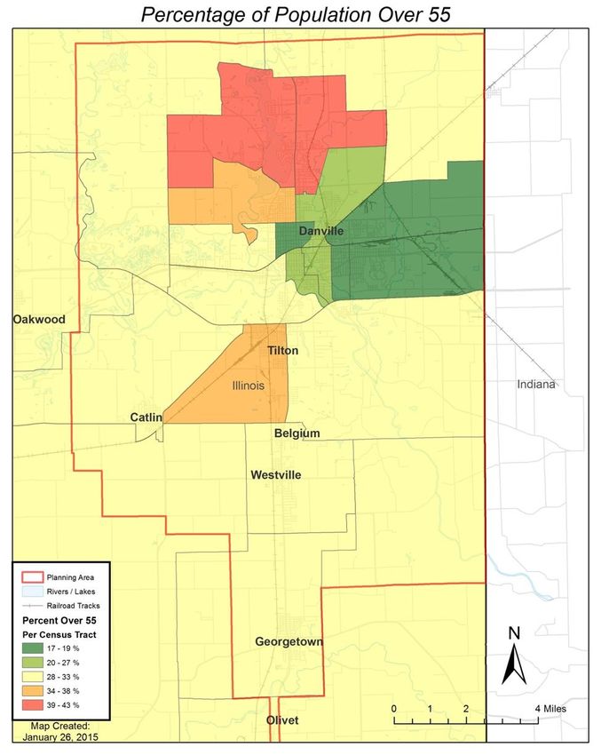
Chapter 2-Existing Conditions & Issues

                                         7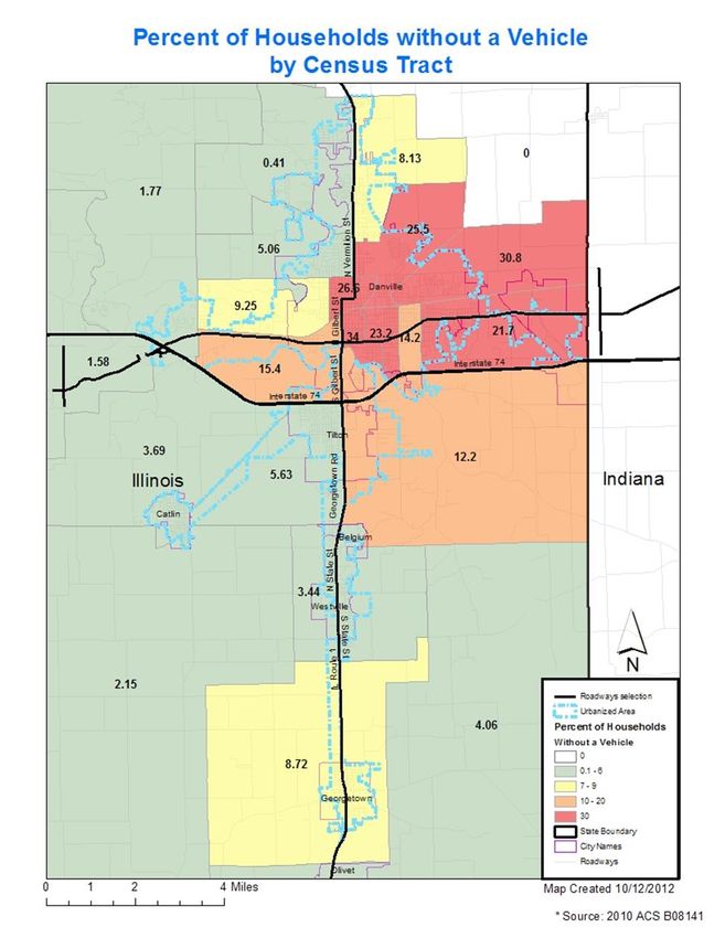
Chapter 2-Existing Conditions & Issues
Planning Process
The DATS 2045 LRTP represents a collaborative effort to establish a vision for the
Danville area’s transportation network and identify a coordinated set of multimodal
projects to achieve it. The plan addresses existing issues and anticipated future
concerns for congestion, safety, access, and connectivity. The planning process
requires a cooperative process between multiple jurisdictions, key stakeholders, and
citizens, designed to create an open dialogue among the community.
The planning process began with analysis of socioeconomic conditions, a review of
current plans and policies, and an assessment of the current transportation network.
Once a full set of recommendations were developed, a prioritization process was
enacted and potential projects through the year 2045 were identified. This plan
provides a blueprint of transportation projects over the next 25 years.
Community Outreach
Citizen involvement, whether through direct contact or by the input of community
representatives, was an integral part of this plan’s development. As a result, MPO staff
reached out to the community throughout the planning process. Along the way, several
overarching issues emerged:
The plan should provide strategies to address the area’s most important corridors
and the most problematic intersections
The plan should consider previous planning efforts
The plan should acknowledge that the movement of people and goods in and
around the area directly affects economic competitiveness
Methods
Several public participation methods were employed throughout the LRTP process, in
attempt to gather the views and needs of our current transportation providers and users.
Transit Providers- DATS Staff contacted both Danville Mass Transit and CRIS
Rural Transit to discuss future needs and to establish their directions moving
forward. In addition to in person meetings, DATS regularly corresponds with
both transit providers.
Bicycle & Pedestrian Focus Groups- DATS staff discussed long-term goals
with Public Health representatives, bicycle enthusiasts, and gathered data from
local Law Enforcement.
8
Chapter 2-Existing Conditions & Issues
American Planning Association-Coordinated LRTP webinars which were
attended in order to keep updated on transportation planning ideas.
Freight Study – Commissioned a freight study completed by Hanson
Engineering, Planning, and Allied Services
Member Input – Solicited via questionnaire
Employer Input Survey- A survey created and distributed for regional
employers was distributed to learn about their experiences, needs and desires.
DATS Technical Committee- Through the production of the 2045 LRTP, DATS
Technical Committee members were asked to review chapter drafts and also
contacted about future project ideas and desires
Milestones Reached
Following the adoption of the 2015 Long Range Transportation Plan to 2040, the MPO
members worked to bring several projects to fruition.
Wayfinding and Signage Study
Wayfinding is a means by which people
can identify where they are relative to
other sites, districts or facilities. It is a
system of easily recognizable identifiers
that connect people to their surroundings
and integrates different geographic areas
by letting people know where they are,
where the path(s) ahead will lead them,
and how they can get there. This system
was designed to project a consistent
image (the brand), guide visitors, and be
sustainable as well as expandable.
9
Chapter 2-Existing Conditions & Issues

Danville MPO Greenways & Trails Plan

The goal of this Greenways and Trails Plan is to
provide a comprehensive inventory for Vermilion
County to use as a resource when developing
various strategies to preserve and protect the
green infrastructure of the region, coordinating
local and regional efforts of various agencies and
community groups, as well as increase
stewardship through understanding and
appreciation of Vermilion County’s natural,
historical, and cultural resources.

Re-Envisioning Danville Downtown Riverfront Conceptual Plan

Connectivity, beautification and potential future uses are the primary focus of this Plan.
In presenting alternatives for underutilized
land along the Vermilion River, this Plan
offers an opportunity to address issues of
growth and quality of life by taking
advantage of available resources and
future development opportunities. The
Downtown Riverfront Plan should serve as
a guide to the City of Danville and other
stakeholders in their efforts to reinvent
and reclaim the Riverfront, connect the
River to the Downtown, and attract
reinvestment in the area.

Bowman Avenue and Vermilion Street Study

Hanson Professional Services and RATIO were
hired by the Danville Area Transportation Study
(DATS) to review Bowman Avenue and Vermilion
Street and evaluate economic and transportation
related alternatives for reducing the concentration
of traffic along Vermilion Street.

                                                                                         10
Chapter 2-Existing Conditions & Issues
Freight Study
The City of Danville commissioned a freight study to
leverage the unique multimodal transportation assets in
the region to facilitate economic growth. However, the
viability of multimodal transportation and freight
development is generally driven by the economic
advantages it provides to the industries served. Thus,
the primary goals of the freight study was to identify
ways to provide an economic advantage to freight
stakeholders; encourage freight-related development
and economic growth; and identify locations where
investment in multimodal infrastructure is economically justified and feasible. Additional
objectives of the freight study included preservation or improvement of the existing
transportation system.
The City of Danville serves as the seat of government for Vermilion County, Illinois.
According to 2010 U.S. Census data, of the County’s 81,625 residents, 50,949 comprise
the Metropolitan Statistical Area. As discussed in depth following, the population of
Vermilion County is expected to decrease by 7.3 percent over the next 30 years. The
population and household growth factors from 2010 to 2050 for the planning area are
shown in Figure 2-1: Forecasted Changes in County Population. By the year 2050, the
population of Vermilion County has been forecasted to reach about 77,219, with 45,792
of those people living in the metropolitan planning area. If this decrease occurs,
Danville will lose its metropolitan status, and the direct MPO funding from FHWA may
dissolve.
Figure 2-1: Forecasted Changes in County Population
Population Source Actual Actual Percent Actual Projected Projected Projected Projected Percent
2000 2010 Change 2015 2020 2030 2040 2050 Change
2000-2010 2010 to 2050
Vermilion Woods and 83,299 81,588 -2.05% 81499 81,406 80,584 78,835 77,219 -7.30%
County Poole
US Census 83,919 81,625 -2.73% 79.394 77,223 75,112 73,061 -12.94%
2010-2010
Trendline
DATS MSA US Census 60,904 58,830 -3.41% 56,827 54,891 53,022 51,214 -15.9%
2010-2010
Trendline
DATS US Census 52,327 50,949 -2.63% 49,607 48,301 47,029 45,792 -12.49%
Urbanized 2010-2010
Area Trendline
City of US Census 33,904 33,027 -2.59% 32,173 31,430 30,530 29,739 -12.28%
Danville 2010-2010
Trendline
Vermilion Lochmueller 83,919 81,625 -2.73% 80,750 80,250 79,176 77,014 -8.23%
County Group Proposed
11Chapter 2-Existing Conditions & Issues
Background & Data Sources
Population data gives a clear picture of the number of people in a designated area,
where people live within that area, and where the population is shifting. Existing
population and demographic data establish a background for future transportation
policies and decisions to address. Analysis of this data illustrates population shifts and
social trends relevant for creating an effective transportation plan.
Because the transportation network is influenced by where people live and work,
patterns need to be identified and considered in order to address changing habits of the
region’s population. This document uses 2010 U.S. Census data for population,
households, automobiles, and employment data for the MPA.
The DATS committees include representation from the City of Danville, City of
Georgetown, CRIS Rural Transit, Danville Mass Transit, Village of Belgium, Village of
Catlin, Village of Tilton, Village of Westville, Catlin Township, Danville Township,
Georgetown Township, Newell Township, Vermilion County, Vermilion Regional Airport,
and the Illinois Department of Transportation.
Population & Households
The municipalities and townships listed above fall within the Metropolitan Planning Area
(MPA) boundary. The MPA includes the Urbanized Area, which is defined as including
a central city (Danville) and contiguous areas totaling at least 50,000 people and a
density of over 1,000 per square mile. The total population for the Urbanized Area as of
2010 was 50,949. See Figure 2-2: MPO population Distribution.
Figure 2-2: MPO Population Distribution
12Chapter 2-Existing Conditions & Issues
Population density is helpful in understanding where the population is concentrated.
MAP 2-2: 2010 Population Density shows densities are highest around city centers with
the exception of Danville, where higher densities occur in the eastern and mid-western
portions of the city; Population density in Danville still tends to be rather low at about
1.31 dwelling units per acre in the City as a whole. However, there are parts of Danville
where this figure rises significantly.
Housing preference is one area that can be heavily influenced by demographic factors.
Like much of the country, a large segment of the planning area’s population was born
during the “Baby Boom” of 1946-1964. At the same time, Vermilion County has
experienced a change in racial and ethnic demographics. A desire for smaller homes,
and homes with lower maintenance requirements are commonly expressed among our
populations. Additionally, household size in the planning area has continued to decline
over the past 50 years, from 2.54 people per household in 1980 to 2.38 in 2010,
according to U.S. Census data.
1
The formula used Danville’s total housing units divided by Danville’s total acreage.
13Chapter 2-Existing Conditions & Issues
MAP 2-2: 2010 Population Density in the Planning Area
14Chapter 2-Existing Conditions & Issues
Aging Population
According to 2010 Census, the MPA had 21,178 citizens age 55 or older, representing
29% of the planning area’s population. As the “baby boomers” continue to age, the
area may see an increased need and usage of transit and paratransit services.
Improvements in roadway signage, lighting, and other elements will also be needed to
accommodate a higher number of drivers with visual or other physical challenges due to
aging.
Maintenance of or an increase in population size will require a positive increase in
health, inbound migration, or both. Access to quality medical facilities means that
people can extend their lifespan and more children are likely to survive at birth. This
reduction in mortality leads to a sustained and even increased population. In Danville,
Carle Foundation Hospital is currently developing a new medical campus to improve
access to lifesaving and preventative health care measures to the people in the DATS
MPA.
Figure 2-3: shows the 2010 Population over 55 years by jurisdiction.
Similarly, Map 2-3: Percentage of Population Over 55 shows the concentration of
population 55 years and older by census tracts.
15Chapter 2-Existing Conditions & Issues
Map 2-3: Percentage of Population Over 55
16Chapter 2-Existing Conditions & Issues
Disabled, Minority, Low Income and Limited English Proficiency Population
Regulatory framework within Title VI regulations- directs every federal agency to identify
and address the effects of all program policies and activities on traditionally
disadvantaged groups defined as “Minority Population”, “Low-Income Population”, and
“Persons with Limited English Proficiency”. The MPO provides for non-discrimination in
transportation planning and programming: through oversight and representation by its
members, by following federal legislation and the 3C transportation planning process,
and by reflecting the legislation in its objectives, policies, and plans.
Environmental justice within the DATS 2045 LRTP is based on three fundamental
principles derived from guidance issued by the USDOT:
To avoid, minimize or mitigate disproportionately high and adverse human health
and environmental effects, including social and economic effects on minority and
low-income populations
To ensure the full and fair participation by all potentially affected communities in
the transportation decision-making process
To prevent the denial of, reduction in, or significant delay in the receipt of
benefits by minority and low-income populations
Minority Population
Poverty level data is vital to the assessment of regional conditions. The American
Community Survey (ACS) collects detailed demographic information regarding racial
identity and cultural origin. Minority populations in the DATS study area represent
similar state and national percentages at approximately 71% Caucasian and 30%
minority. Figure 2-4: Minority Population Comparison Data shows graphs comparing
local, state, and national minority distribution percentages.
17Chapter 2-Existing Conditions & Issues
Figure 2-4: Minority Population Comparison Data
Vermilion County Population Illinois Population
4.3%
0.2% 0.6%
15.8%
13.0%
4.6%
0.2%
14.0%
72.0%
83.0%
United States Population Danville Metropolitan Area
16.3% 1% 5%
0%
4.8%
23%
0.9%
12.6%
72.4%
71%
White African American American Indians Asian Hispanic
18Chapter 2-Existing Conditions & Issues
Map 2-4: Percent of Population Below Poverty Level by Census Tract
Poverty and Income
The average percentage of population below poverty level in a census tract, using 2010
census data is approximately 19.12%. Map 2-4: Percent of Population Below Poverty
Level by Census Tract displays the poverty level average per census tract based on
2010 U.S. Census data. The map also depicts the central and eastern portion of
Danville having the highest concentration of poverty, while the northwest section of the
planning area has the lowest concentration of population below the poverty level.
19Chapter 2-Existing Conditions & Issues
Economic Indicators Influence Transportation Decisions
Aside from population and age data, regional economic analysis is a significant factor in
creating a transportation system that services the needs of the entire population. By
examining factors such as means of transportation to work, commuting times and
vehicle availability, we are building a foundation for discussion of future transportation
projects.
Vehicular travel is the most predominant use of travel in the planning area, with 96
percent of workers driving to work (cars, trucks, or vans); this number illustrates the
extent of the workforce that is dependent on the roadway system. In March 2020, the
world experienced the beginning of the COVID-19 pandemic that negatively impacted
the economy and travel. “Shelter in Place” orders reduced the extent to which
businesses operated causing many of them to close. In fact, the Illinois Department of
Employment Security received over 500,000 unemployment claims between March 1
and April 4 of 2020. In the same time frame, restaurants converted into delivery-only
facilities and other industries allowed employees to work from home. The development
of COVID-19 has had a tremendous impact on the number of vehicle miles travelled.
According to Streetlight Data, the DATS planning area saw nearly a 41% reduction in
VMT from March 2 (with a reported 2,890,000 miles traveled) to April 2 (with a reported
1,720,000 miles travelled).
These factors and events can negatively affect population growth/maintenance unless
steps are taken to minimize the impact. A commonly accepted method of increasing
population density has been to combine street life and walkability with lower crime and
good public services. However, until rationale is presented for people to behave
differently, social distancing will likely remain a priority. This means that fewer people
are migrating at this time; but, once the travel bans are lifted, it is possible that people
from larger cities will seek to relocate to areas with smaller populations and more open
space to lower the likelihood of infection. The American Planning Association reported
that cities that have re-opened during this pandemic saw a decrease in public transit
use, an increase in technology use for interpersonal contact, and an increase in the use
of personal vehicles and active transportation methods**.
https://www.streetlightdata.com/vmt-monitor-by-county/#emergency-map-response
20Chapter 2-Existing Conditions & Issues
Figure 2-5: Means to Work
Means to Work
Drive to Work Walk
Public Transportation Bicycle, Motorcycle, Other
2% 1%
96%
Employment
Figure 2-6: Major Employers in Vermilion County shows the 34 largest employers in
Vermilion County. In 2010, the total employed population in Vermilion County was
31,751 2 with Danville hosting the largest employment numbers in the region. The total
employment for the region in 2045 is projected to be approximately 33,132 which would
be an increase of almost 4.35% from 2010.
2
Woods and Poole Data supported by Lochmueller Group research
21Chapter 2-Existing Conditions & Issues
Figure 2-6: Major Employers in Vermilion County
Top Employers in Vermilion County, Illinois
Rank Employer Industry
1 Veterans Affairs Illiana Health Care System Healthcare
2 Vermilion County Public Schools including Education
Danville D#118
3 McLane Midwest Company, Inc. Distribution
4 OSF HealthCare Sacred Heart Medical Center Healthcare
5 Vermilion County Government Government
6 Insurance
Blue Cross Blue Shield
Processing
7 Quaker Oats Manufacturing
8 KIK Custom Products Manufacturing
9 AutoZone Distribution
10 Danville Metal Stamping Manufacturing
11 Carle Physician Group Healthcare
12 Watchfire Signs Electronics
13 Thyssen-Krupp Crankshaft Manufacturing
14 Viscofan Manufacturing
15 Danville Correctional Center Government
16 Cannon Cochran Management Services, Inc. Financial Services
17 The Sygma Network Distribution
18 Walgreen Accounting and Help Desk Center Financial Services
19 Genpact Financial Services
20 City of Danville Government
21 Liberty Village Healthcare
22 Thyssen-Krupp Presta Manufacturing
23 Hyster-Yale Manufacturing
24 Danville Area Community College Education
25 Private Parochial Schools in Vermilion County Education
26 Mervis Industries Manufacturing
27 Full-Fill Industries Manufacturing
28 Flex-N-Gate Plastics Manufacturing
29 Teasdale Foods Manufacturing
30 Bunge Milling Manufacturing
31 Silgan Manufacturing
32 Steelgrip Manufacturing
33 Fiberteq Manufacturing
34 Trigard/Greenwood Plastics Manufacturing
Source: Vermilion Advantage survey of businesses, June 2020
22Chapter 2-Existing Conditions & Issues
Land Use
Since the late 1970s the majority of development in the planning area has occurred
along the north and western edges of Danville. Suburban style development with
separated land uses prevails, although there is a clear differentiation between the urban
and rural areas. The existing transportation system has focused on the personal
vehicle since the mid-20th Century with the older parts of the County maintaining a
strong grid street system, and the newer residential streets developed in more
curvilinear patterns with cul-de-sacs being common in some neighborhoods.
Summarizing current land use patterns and local zoning generates an understanding of
the existing built environment in the MPA. Zoning and land use patterns also assist in
projecting future growth areas. The Urbanized Area covers approximately 31 square
miles, which is roughly 19,850 acres.
As fuel costs continue to rise, the need for transportation options, as well as lifestyle
options, becomes more apparent. It is likely that the personal vehicle will continue to be
the dominant form of transportation for the foreseeable future. However, the ability to
conveniently access alternate modes of transportation, such as bicycling, transit, and
walking, is becoming increasingly important.
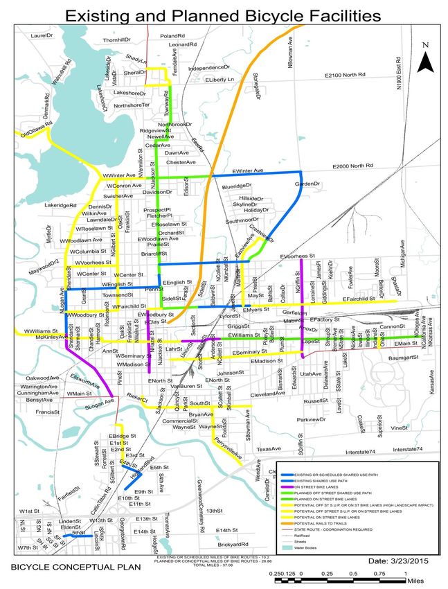
Environment
Protecting and enhancing the environment is a concern shared throughout the
transportation community. MAP-21 planning factors provide guidance to protect the
environment, integrate the planning and environmental processes, and promote a
streamlined process for reviews and permitting. The coordinated effort of the LRTP
supports the protection and enhancement of the environment and sets the stage for the
streamlined process outlined by NEPA (National Environmental Policy Act) regulations.
Map 2-5: DATS Environmental Water Features depicts the existing relationship between
green space, built infrastructure, and bodies of water.
23Chapter 2-Existing Conditions & Issues
Map 2-5: DATS Environmental Water Features
24Chapter 2-Existing Conditions & Issues
Automobile Ownership
The American Community Survey considers household access to a vehicle to help
determine the need for special transportation services for the elderly and disabled, and
also to plan for emergency transportation services for areas with high concentrations of
households with no vehicle available. The automobile ownership data used in this
document is from the Illinois Department of Motor Vehicles and the 2010 U.S. Census.
92 percent of workers in the MPA drive or carpool to work; this number illustrates the
dependency of our working class on our roadway system. As of July 2014, Vermilion
County had over 81,000 registered vehicles (See Figure 2-7). However, almost 31
percent of households in eastern Danville reported no vehicle ownership.
FIGURE 2-7: Vermilion County Registered Vehicles July 20143
3
Registered Vehicle Data was gathered in July 2014 from the Illinois Department of Motor Vehicles
25Chapter 2-Existing Conditions & Issues
Map 2-6: Percent of Households Without a Vehicle by 2010 Census Tract
26Chapter 2-Existing Conditions & Issues
Existing Transportation Conditions
The existing transportation system within the MPA contains assets, opportunities, and
challenges for the community. Identifying areas experiencing congestion and planned
improvement projects will enable a more efficient and accessible transportation system.
At this time, most cities in the United States are concerned with the costs associated
with the operation and maintenance of transportation facilities. These financial
challenges demand a closer look at the priorities of the community. Maintenance costs
can be significantly reduced if maintenance is done when streets and other
transportation infrastructure are in relatively good condition. As maintenance is
deferred, condition continues to decline and the costs of repairs rise dramatically.
Techniques for reducing traffic demands by deferring trips to alternate modes or
minimizing peak demands can reduce the need for projects that increase capacity on
roads, resulting in a reduction in the cost for new projects.
Pedestrian and Bicycle Facilities
Pedestrian facilities are provided and planned throughout the metropolitan planning
area. Provision of an adequate system of pedestrian sidewalks and bicycle or multi-
purpose pathways is critical for public safety and as a means of encouraging alternative
modes of travel. The current bike route network for the planning area is closely tied to
the street network (See Map 2-7: Existing and Planned Bicycle Facilities). It includes
existing paved and unpaved routes, proposed trails and trail easements, on-street
bicycle routes, bicycle lanes, and multi-use paths. Bicycles play an important role in the
community by providing a healthy alternative to the automobile, reducing traffic
congestion, improving air quality, increasing public health, and creating a more
balanced transportation system.
27Chapter 2-Existing Conditions & Issues
Map 2-7: Existing and Planned Bicycle Facilities
28Chapter 2-Existing Conditions & Issues
Public Transit System
Public transportation is an essential component of the existing transportation system
and should be integrated with all other transportation modes. Providing efficient transit
service relies on good pedestrian connections at the beginning and end of the trip.
Transit service is also influenced by development density, community policy, location of
transportation corridors and activity centers, as well as by the design of activities along
those corridors and the uses they serve. Other factors such as an abundant supply and
low cost parking, low travel time, gas prices and minimal congestion also affect transit
demand. These public services are critical to those persons who are dependent on
public transportation, especially our low-income and elderly populations.
Danville Mass Transit (DMT) provides fixed-route bus service within the City of Danville
and parts of Vermilion County, as well as bus service between Vermilion and
Champaign counties. With 14 regular fixed-routes in operation (See Map 2-8: DMT
Fixed-Route Service), DMT provides nearly 650,000 rides annually (Figure 2-9: DMT
Annual Ridership).
Map 2-8: Fixed Route Service
29Chapter 2-Existing Conditions & Issues
In addition to providing services for the transit dependent, DMT also offers
services as an alternative to the automobile for the non-transit dependent or
choice riders. The regular fixed route transit system runs Monday through Friday
from 6:15 am to 9:45 pm. These routes service major employment and education
service areas.
Figure 2-8: DMT Route Descriptions
Route Service Areas
1 Grant/Logan Lakeview College of Nursing, City Hall, Vermilion County Museum, Lamon
House, OSF Hospital, Center for Children's Services
2 Gilbert Edison Elementary, Garfield Elementary, Liberty Elementary, Schlarman
Academy, City Hall, Village Mall, Wal-Mart Plaza, Vermilion County Museum ,
Carle Clinic, Christie Clinic, CRIS Senior Services, Social Security
Administration, IDES
3 Vermilion Edison Elementary, First Baptist Christian School, Liberty Elementary,
Schlarman Academy, Danville Public Library, Village Mall, Vermilion County
War Museum, Carle Clinic
4 Bowman Danville Lutheran School, Danville Care Center, Wal-Mart, Deercreek Manor,
Meijer , Kohl's, TJ Maxx, Lowe's, Christie Clinic, County Market, Winter
Park, Bowman Estates, Edison School
5 Fairchild Danville High School, East Park Elementary, Northeast Magnet School,
Danville Housing Authority, Municipal Pool and Sprayground, Boys and Girls
Club
6 Main/Fairchild Danville Area Community College, Danville High School, East Park Elementary,
Northeast Magnet School, Trinity Lutheran School,
Veteran's Affairs Medical Center, Danville Area Community College, Municipal
Pool and Sprayground, Boys and Girls Club
7 Williams/Main Danville Area Community College, Trinity Lutheran
School, Veteran's Affairs Medical Center
8 Douglas Park Vermilion County Courthouse, Public Safety Building, Vermilion County Health
Department, David S. Palmer Arena, IL Department of Human Services, City
Hall
9 Georgetown Illinois Secretary of State Office, Westville High School, Westville Village Hall,
Georgetown City Hall, Georgetown High School
10 Danville-Champaign Carle Hospital, OSF Hospital, Illinois Terminal, Various stops along University
Avenue
11 Vermilion Edison Elementary, First Baptist Christian School, Liberty Elementary,
Schlarman Academy, Danville Public Library, Village Mall, Vermilion County
War Museum, Carle Clinic
12 Heights- South Danville Crosspoint Human Services, Southview Upper Elementary School, Vermilion
County Court House, City Hall, Danville Stadium, Ellsworth Park
13 Tilton Southwest Elementary School, Illinois Secretary of State office, Gardenview
Manor
14 Lynch Danville High School, Danville Housing Authority, Trailways Bus Station, Meade
Park School, Danville Area Community College,
Veteran 's Affairs Medical Center
30Chapter 2-Existing Conditions & Issues
Two bus routes provide DMT service to the MPA outside of the City of Danville,
connecting the MPA as a whole. Route 9 provides service between Danville
and Georgetown. Route 13, implemented in June 2008, provides bus service
between Danville and Tilton. A third route, Route 10, provides service outside
of the MPA to Champaign's Illinois Terminal. This route provides a connection
to Carle Hospital, OSF Hospital, and the University of Illinois.
DMT Ridership
Ridership numbers indicate growth in transit use and reveal trends for future
growth. Riders with disabilities that exclude them from using the Danville Mass
Transit (DMT) fixed-route service may be eligible for para-transit service after
completing the ADA certification process with DMT. This service is offered in
accordance with the Federal Americans with Disabilities Act (ADA). All ADA
ride tickets are purchased at the DMT office.
Figure 2-9: DMT Annual Ridership
Number of Passengers
Annual Trend
7
Month
31Chapter 2-Existing Conditions & Issues
CRIS Senior Rides
CRIS Rural Mass Transit District provides transportation options to meet the
needs of Vermilion County residents, especially the elderly and persons with
disabilities. CRIS has multiple programs through which transportation services are
provided. Mainly, CRIS is a coordinated public transit service provider that
operates curb-to-curb demand response services open to residents in Vermilion
County. As part of its service network, CRIS also holds contracts to provide
service for several area programs.
Figure 2-10: CRIS Ridership Data
FY 2010 FY2011 FY2012 FY2013 FY2014
Vermilion 42,438 38,443 47,471 61,289 63,503
County
Champaign 2,003 15,811 16,972 17,091
County
Total 42,438 40,446 63,282 78,261 80,594
All riders over the age of 60 who are picked up and dropped off within the corporate city
limits of Danville are eligible for CRIS Senior ride service with a donation-based fare.
Rides may be to and from any origin in the service area and for any purpose as long as
a reservation has been made with CRIS.
Additionally, CRIS provides contract service transportation for Crosspoint Human
Services, Worksource Enterprises, McCall’s Key Club Adult Day Care and almost every
nursing home and assisted living facility in Vermilion County. Additional senior
transportation services within the MPA include Danville and Newell Township Senior
transit operations. Although they are small scale transportation operations, they provide
a necessary and convenient senior transit option in the MPA for seniors 60 and over.
Streets and Highways
A detailed profile of existing roadway conditions, road safety factors, and corridors of
significance is necessary for moving forward with planning priorities. Existing roadway
conditions analysis includes variables such as ADT counts, number of lanes, and
functional classification designations. Additionally, significant corridors in the planning
area described in detail, including the corridor function, surrounding land uses, and
potential development within that corridor are necessary. This analysis leads to a list of
planned roadway improvements through 2045.
32Chapter 2-Existing Conditions & Issues
The Danville MPO is served today by an extensive system of streets and highways.
This system ranges from interstate roadway down to local residential streets that help
form the character of neighborhoods. The street and highway system provides vital
connections within the region, connections to other cities and regions, and connections
among various modes of travel within the metropolitan area.
The roadway system primarily consists of a typical grid system. This includes
Interstate, U.S. and State Highways, major arterials and collector streets, and local
streets. Local streets are by far the largest portion of the total containing over 286 lane
miles.
ILLINOIS DEPARTMENT OF TRANSPORTATION
Office of Planning and Programming – Planning & Systems Section
Mileage by 5-Year Functional Classification
Table HS-4 Published December 2017
*Measured In Lane Miles
The Federal Highway
* Administration notes that “The concept of functional classification
defines the role that a particular roadway segment plays in serving this flow of traffic
through the network.”4 This classification system provides for relatively efficient
movement throughout the community, resulting in good circulation. Exceptions can be
found during peak travel periods, particularly on North Vermilion (IL Route 1) and South
Gilbert (IL Route 1), but flow is enhanced by synchronized traffic signals.
4
FHWA Highway Functional Classification Concepts, Criteria and Procedures 2013 Edition
33Chapter 2-Existing Conditions & Issues
Map 2-9: Roadway Functional Classification
34Chapter 2-Existing Conditions & Issues
Map 2-10: 2020 Average Daily Traffic
Planning Area
35Chapter 2-Existing Conditions & Issues
Safety
An important part of the Danville MPO’s transportation planning process involves the
collection of transportation related crash data. One of the MPO’s goals is to reduce the
overall number of crashes, fatalities and injury crashes throughout the planning period.
To achieve these fundamental goals, it is important that national, state and local
standards align with education, enforcement, engineering, and evaluation. Bridges and
overpasses have been improved in recent years to make travel safer and easier. By
separating trains and cars we are working to reduce the potential for collisions, as well
as reducing the delay motorists experience while waiting on trains to pass.
Figure 2-11: Fatal Motor Vehicle Crash Data for MPA
Fatal Motor Vehicle Crashes1
Crash Date Crash Date (Month)
(Year) January February March April May June July August September October November December Total
2013 1 0 0 1 2 1 0 2 1 2 0 0 10
2014 0 1 0 1 0 0 0 1 1 2 1 0 7
2015 1 0 2 1 0 1 1 2 0 2 0 0 10
2016 0 1 2 0 1 0 0 0 1 2 0 1 8
2017 0 1 0 2 1 0 3 0 3 2 2 1 15
2018 2 1 0 2 0 0 0 2 0 1 0 3 11
Total 4 4 4 7 4 2 4 7 6 11 3 5 61
Data Sources:
1
Fatality Analysis Reporting System (FARS): 2004-2017 Final File and 2018 Annual Report File (ARF)
As a result of the Federal Highway Administration’s (FHWA) emphasis on transportation
safety, the primary focus of highway planning and investment is on improving the safety
of the transportation system. The Illinois’ Strategic Highway Safety Plan (SHSP) is a
statewide initiative to eliminate all fatal and serious injury crashes on all Illinois
roadways. The Danville MPO, along with the participating municipalities and Vermilion
County, has been involved in several efforts to address the emphasis areas of the
state’s SHSP. Map 2-11: January 2013-December 2018 Crash Data displays the
results from a crash analysis of state and local crash reports from January 2013-
December 2018.
36Chapter 2-Existing Conditions & Issues
Map 2-11: January 2013- December 2018 Crash Data for MPA
All Crashes
By Year
SOURCE: National Highway Traffic Safety Administration (NHTSA) Motor Vehicle Crash Data Querying and Reporting
Motor Vehicle Crashes Years: 2013-2018
37Chapter 2-Existing Conditions & Issues
Significant Corridors within the MPA
The corridors listed below have been identified as significant transportation corridors for
the DATS MPA. These corridors were selected based on attributes such as regional
connectivity and ADT. Additionally, this list highlights areas of focus for future regional
transportation planning and improvements.
1. Main Street Corridor: The Main Street (US Route 150 and US Route 136)
corridor is the major east-west arterial route through the City of Danville. This
route is paralleled by Interstate 74, but still carries high traffic volumes on its’ four
to five undivided lanes. The US Route 150 portion of this roadway covers the
western portion of the MPA, an area with opportunity for future development.
Within the City of Danville, Main Street is the primary connection between
several major community institutions including Danville Area Community College
and the Veterans Administration hospital. East of Bowman Avenue, Main Street
provides vital connections to Eastgate employment center. Recent widening of
Main Street intended to increase the roadway’s freight traffic capability. A 2014-
2015 corridor study focused on improving the East Main Street Corridor (From
Bowman Avenue- Kansas Street); recommendations from this study should be
implemented in the coming years.
2. Fairchild Street Corridor: This corridor provides a vital east-west connection for
local traffic in the City of Danville. In 2014, an extensive grade separation was
completed, to provide continuous connection free of train delays. Fairchild
provides access from residential neighborhoods to medical centers, the public
high school, and other community services.
3. Voorhees Street Corridor: Voorhees Street provides an integral connection to
employment and industrial areas in the eastern part of the planning area, from
the residential portions of the region. The corridor includes two at-grade railroad
crossings, which causes frequent unplanned delays for roadway users.
4. Bowman Avenue Corridor: Bowman Avenue is a major north-south arterial
connection within the MPA. The existing Interstate 74 interchange provides the
potential for commercial development, with quick access to I-74. This roadway
also provides a regional connection to residential, employment, and service
areas, as well as the Vermilion Regional Airport.
5. Winter Avenue Corridor: The Winter Avenue corridor is a collector roadway
providing service to residential areas along with connection to employment
centers. Additionally, Winter Avenue provides connection to the City of Danville’s
Winter Park and AMBUCS Sprayground for Everyone. Recent construction
improvements including a railroad overpass reconstruction and shared-use path
creation provide safety and functionality to this roadway.
38Chapter 2-Existing Conditions & Issues
6. IL Route 1 Corridor- The IL Route 1 corridor is the major north-south arterial
connection for the MPA. Outside of capacity and congestion issues, this corridor
experiences conflicts with land use developments and access management.
Due to ADT and vehicle speeds, this corridor is not recommended for on-street
bicycle facilities. However, bicycle and pedestrian accommodations need to be
considered in connecting the retail development to the surrounding residential
areas.
a. North of Winter Avenue: IL Route 1 north of Winter Avenue is bordered
by commercial development and surrounded by residential
neighborhoods. With the prevalence of retail business, health care
services, and residential neighborhoods, Route 1 north of Winter Avenue
hosts a number of regional destinations and major transit stops. Current
ADT counts peak above 25,000 for this portion of the corridor.
b. Fairchild Street to Winter Avenue: The IL Route 1 connection between
Fairchild Street and Winter Avenue serves predominantly through traffic.
Current ADT counts in this area peak around 19,000 vehicles per day.
Surrounding uses are primarily residential along with some commercial
businesses.
c. Interstate 74 to Fairchild Street: A mix of uses surrounds IL Route 1
between Interstate 74 and Fairchild Street, including residential, retail and
strip development. Traffic volumes throughout this corridor are in excess
of 24,000 vehicles per day. This corridor has great redevelopment
potential for the City of Danville, due to its proximity to Interstate 74, and
appropriate land uses should be studied to determine how to
accommodate alternative modes of transportation from the City center.
Efforts should be made to examine improvements around the Interstate 74
interchange, as well as improve access management along the corridor.
d. Interstate 74 to Lyons Road: This section of IL Route 1 serves as a
through traffic connection for residents of the southern portion of the MPA
by providing access to Interstate 74 and the City of Danville. This corridor
has great development and redevelopment potential for Tilton and
Hegeler, both of which have begun to capitalize on. It has an ADT of
1600.
e. South of Lyons Road: This corridor is a major regional connection into
the MPA, functioning primarily as the main north-south transportation
route for the City of Georgetown and Village of Westville. IL Route 1
south of Lyons Road acts as the southern gateway into and out of the
MPA to employment centers, retail development, and Interstate 74.
39Chapter 2-Existing Conditions & Issues
7. Lynch Road Corridor: This collector road connects Danville’s Main Street with
Interstate 74 on the eastern edge of the MPA. Lynch Road is a vital connection
for the industrial and commercial employment centers, as it provides direct
connection to the Eastgate industrial park and Interstate 74 interchange. This
roadway provides transportation connections for employees working in the area,
visitors lodging at hotels, and freight coming in and out of the MPA.
8. Interstate 74 Corridor: The Interstate 74 Corridor is the primary route for
through traffic in the MPA and provides a major transportation asset to the MPA
because of its connection to the regional and national transportation networks.
Freight Transportation
Rail, aviation and truck freight transportation modes play an important role in the
region’s transportation system and economy. These modes provide a vital connection
for manufacturing corporations located in the area to move goods throughout Illinois, the
Midwest, and the nation as a whole.
Trucking is an important freight distribution component for the DATS MPA’s
transportation system. Trucks transport manufactured products from industries to all
parts of the country, they make farm-to-market shipments to Illinois grain producers,
deliver coal and other minerals to Illinois ports, and ship consumer goods to retailers
throughout the state.
The National Truck Network created by Surface Transportation Assistance Act (STAA)
of 1982, provides a connected system for truck travel. As a result of STAA, a
“Designated State Truck Route System for Large Vehicles and Combinations” was
developed and implemented in Illinois. This system, designated by IDOT, provides safe
accommodations for trucks and governs the mobility and accessibility of the truck
transportation network. The designations include the classifications listed below:
SELECTION OF DESIGN VEHICLE AT INTERSECTIONS
(Functional Classification)
Highway Type Design Vehicle Maximum Length Maximum Length
of Trailer Kingpin to Center
Allowed (m) Rear Axle (m)
Class I WB-67 (WB-20) 53′ (16.16 m) 45.5′ (13.87 m)
Class II WB-65 (WB-20) 53′ (16.16 m) 45.5′ (13.87 m)
Non-designated State WB-55 (WB-17) 53′ (16.16 m) 42.5′ (12.96 m)
Non-designated Local WB-50 (WB-15) Not Specified Not Specified
Source: http://www.idot.illinois.gov/assets/uploads/files/doing-business/manuals-split/design-and-
environment/bde-manual/Chapter%2036%20Intersections.pdf
40Chapter 2-Existing Conditions & Issues
There are three designated truck routes within the DATS MPA (see Figure 2-12) that fall
within the IDOT truck route designated classification system. Additionally, the City of
Danville identifies Bowman Avenue, East Voorhees Street, Vermilion Street, Gilbert
Street, Lynch Spur Road, and Southgate Drive as designated truck bypass routes.
Figure 2-12: Designated Truck Routes
Designated Location Route
Truck Route From To Classification
I-74 Indiana State Line Champaign County Line I
US 136 Champaign County Line Indiana State Line II
US 150 I-74 Edgar County Line II
Map 2-12: Truck ADT within the City of Danville
SOURCE: 2019 GIS- Getting Around Illinois Map - Illinois Department of Transportation 2300 S. Dirksen Parkway Springfield, IL 62764.
41Chapter 2-Existing Conditions & Issues
Rail Overview
The Danville area is served by four railroads consisting of two Class I railroads (CSX
and NS) and two shortline railroads (Kankakee, Beaverville, & Southern Railroad and
Vermilion Valley Railroad). The Norfolk Southern line bisects the City from southwest to
northeast and carries approximately 50 trains per day.
The CSX line enters the City from the southeast and carries approximately 15 trains per
day. The CSX rail line has several spur connections to industries on the east side of
Danville. The nearest rail passenger station is provided by Amtrak and is available at
the Illinois Terminal in Champaign, Illinois. There are over 50 at-grade crossings within
the Danville Urbanized Area. These at-grade rail crossings can be a significant source
of traffic delays and safety concerns, as well as an impediment to the provision of
services and movement of people in and around the community.
The DATS MPA contains one intermodal development site, which is located in the
Eastgate Industrial Park and provides regional connections to Chicago and Indiana.
These connections link the DATS MPA with the surrounding region, but also bring a
large volume of train traffic that passes through the MPA.
Aviation Overview
Officially activated in 1946, the Vermilion Regional Airport (VRA) provides runway
facilities and associated taxiways. The longer runway is able to accommodate large
corporate and commercial aircraft. The VRA supports private and corporate owned
aircraft by providing hangar rentals, land leases, fuel services, and airport infrastructure
maintenance. A critical function of the airport is to facilitate economic development by
providing a means for regional, national, and international corporations to have direct
access to the community by means of corporate aircraft.
Of the 817 total acres located at the airport facility, the property includes approximately
177 acres of developable land. The VRA authority is marketing this land as a business
development park for companies that wish to take advantage of the aviation link. The
Industrial/Business Airpark Plan prepared by Crawford, Murphy & Tilly, Inc. in 2000,
provides a detailed plan for the future development of this land. Infrastructure
improvements to the planned development area include improving ground access.
Future improvements to Bowman Avenue and the addition of the proposed Beltline
Road would provide sufficient airport access.
42Chapter 3-The Vision Moving Forward
The success of the LRTP lies within a well-rounded public outreach effort that fosters
community interaction. The primary mechanism for on-going public input to the Long
Range Transportation Plan is through the MPO’s Technical Advisory Committee; which
is composed of regional business leaders, but was also guided by public sentiment
about long term transportation investments in Vermilion County. The 2045 LRTP was
based upon continuous dialogue with stakeholders, government officials, economic
development interests, the general public, and other community organizations.
A page on the DATS website (http://dats-il.org/2045LRTP) was developed for the 2045
LRTP update which included information about the timeline, meeting agendas, the
scope of work, and other information about public engagement.
This LRTP reflects the DATS 2045 goals and objectives which were updated and
reviewed by the DATS Technical Committee and moves DATS closer to addressing the
MAP-21 and subsequent FAST Act performance measures. In 2018, the MPO voted to
adopt the performance measures established by IDOT. This data is used as a baseline
to determine how well each standard is being met.
Performance-based Planning
Performance-based planning refers to the application of performance management- a
“strategic approach that uses performance data to support decisions to help achieve
desired performance outcomes.” Performance-based planning occurs within the
context of established transportation planning and programming processes used by
agencies to deliver a multimodal transportation system. The outcome of performance-
based planning is a constant, or a desired incremental improvement in reaching our
goals. If a particular project did not help us meet our stated goals, or was more
effective than originally thought, that information can help us make better decisions in
the future. Done properly, performance-based planning can not only bring transparency
and an increasing movement towards our goals, it can also serve to make a compelling
case for LRTP 2045 and why our communities are and should be invested in its
outcome.
Measuring how well we achieve our goals is both an art and a science. There are two
types of measures: goals such as numbers of crashes, which are easy to quantify, and
subjective measures such as “quality of life”, which are tougher to measure but are just
as important.
MAP-21 identifies several national goal areas and requires DOTs and MPOs to develop
a performance-based approach to support the national goals. As part of this process,
USDOT in consultation with state DOTs, MPOs, and other stakeholders will establish
performance measures corresponding to the national goals. State DOTS and MPOs
43You can also read