Byron Bay Bus Interchange Redevelopment - SMEC Statement of Heritage Impact Final - Transport for NSW
←
→
Page content transcription
If your browser does not render page correctly, please read the page content below
Byron Bay Bus Interchange
Redevelopment
Statement of Heritage Impact
Final
SMEC
November 2018
Document Control Page
CLIENT: SMEC
PROJECT: Byron Bay Bus Interchange Redevelopment - Statement of Heritage Impact
ADDRESS: Butler Street, Byron Bay
EXTENT HERITAGE PTY LTD INTERNAL REVIEW/SIGN OFF
WRITTEN BY DATE VERSION REVIEWED APPROVED
T Brassil
12/06/18 1 RB
07/11 V2
Copyright and Moral Rights
Historical sources and reference materials used in the preparation of this report are acknowledged and referenced in
figure captions or in text citations. Reasonable effort has been made to identify, contact, acknowledge and obtain
permission to use material from the relevant copyright owners.
Unless otherwise specified in the contract terms for this project EXTENT PTY LTD:
Vests copyright of all material produced by EXTENT HERITAGE PTY LTD (but excluding pre-existing material and
material in which copyright is held by a third party) in the client for this project (and the client’s successors in title);
Retains the use of all material produced by EXTENT HERITAGE PTY LTD for this project for EXTENT HERITAGE
PTY LTD ongoing business and for professional presentations, academic papers or publications.
EXTENT HERITAGE / Byron Bay Bus Interchange Redevelopment – STATEMENT OF HERITAGE IMPACT ii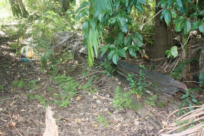
CONTENTS

STATEMENT OF HERITAGE IMPACT ..................................................................................
1     INTRODUCTION................................................................................................. 1
    1.1     Project Description .................................................................................................................. 1
    1.2     Approach and Methodology .................................................................................................... 1
    1.3     Limitations ............................................................................................................................... 1
    1.4     Authorship ............................................................................................................................... 1
    1.5     Ownership ............................................................................................................................... 2
    1.6     Terminology............................................................................................................................. 2

2     SITE .................................................................................................................... 3
    2.1     Location ................................................................................................................................... 3

3     LISTINGS AND CONTROLS .............................................................................. 5
    3.1     Statutory Listings ..................................................................................................................... 5

4     HISTORIC CONTEXT ......................................................................................... 8
    4.1     Byron Bay - Indigenous Background. ..................................................................................... 8
    4.2     European Colonisation .......................................................................................................... 10
    4.3     Byron Bay Railway Station .................................................................................................... 13
    4.4     The Loco Siding Area ............................................................................................................ 17
    4.5     Byron Bay Railway Water Supply Arrangements.................................................................. 23
    4.6     Railway Water Tanks: 1892 - 1898 ....................................................................................... 26

5     PHYSICAL DESCRIPTION .............................................................................. 29
    5.1     The Loco Siding area ............................................................................................................ 29
    5.2     The Water Tower .................................................................................................................. 31
    5.3     Other features ....................................................................................................................... 36

6     HERITAGE SIGNIFICANCE ............................................................................. 42
    6.1     Byron Bay Railway Station .................................................................................................... 42
    6.2     Water Tower .......................................................................................................................... 45
    6.3     Significance of Other Elements ............................................................................................. 48

7     PROPOSED WORKS ....................................................................................... 49
    7.1     Scope .................................................................................................................................... 49
    7.2     Rationale ............................................................................................................................... 50
    7.3     The Water Tower .................................................................................................................. 57

8     ASSESSMENT OF HERITAGE IMPACT ......................................................... 61
    8.1     Built Heritage ......................................................................................................................... 61
    8.2     Landscape Heritage .............................................................................................................. 62
    8.3     Curtilage ................................................................................................................................ 62
    8.4     Views and Settings ................................................................................................................ 63

EXTENT HERITAGE / Byron Bay Bus Interchange Redevelopment – STATEMENT OF HERITAGE IMPACT                                                                iii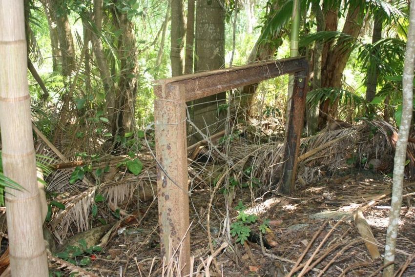
8.5     Heritage Items in the Vicinity ................................................................................................. 63
    8.6     Non-Indigenous Archaeology ................................................................................................ 63
    8.7     Indigenous Archaeology ........................................................................................................ 64
    8.8     Compliance with CMP Recommendations ............................................................................ 64
    8.9     Compliance with SHR Management Recommendations ...................................................... 66

9     STATUTORY CONTROLS ............................................................................... 67
    9.1     Heritage Act 1977 ................................................................................................................. 67
    9.2     Byron Local Environmental Plan 2014 .................................................................................. 69
    9.3     Byron Development Control Plan 2014 ................................................................................. 69

10 CONCLUSION AND RECOMMENDATIONS ................................................... 71
    10.1    Statement of Heritage Impact ............................................................................................... 71
    10.2    Recommendations ................................................................................................................ 71

EXTENT HERITAGE / Byron Bay Bus Interchange Redevelopment – STATEMENT OF HERITAGE IMPACT                                                        iv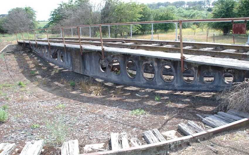
1 INTRODUCTION
1.1 Project Description

In 2018, EXTENT Heritage Pty Ltd was commissioned by SMEC to prepare a Statement of Heritage
Impact for the redevelopment of the western side of Byron Bay Railway Station to create a Bus
Interchange area accessed from Butler Street, Byron Bay. The purpose of the report is to assess the
proposed works for the potential impacts they may have on the heritage significance of the Byron Bay
Railway Station and Yard group, which is a place of State heritage significance listed on the NSW
State Heritage Register.

1.2 Approach and Methodology

The methodology used in the preparation of this Statement of Heritage Impact is in accordance with
the principles and definitions as set out in the guidelines to The Burra Charter: The Australia ICOMOS
Charter for Places of Cultural Significance and the latest version of the Statement of Heritage Impact
Guidelines (2002) by the NSW Office of Environment and Heritage.

This Statement of Heritage Impact (SOHI) will review the relevant statutory heritage controls, assess
the impact of the proposal on the subject property and make recommendations as to the level of
impact.

1.3 Limitations
                                                                                           th
The site was inspected and photographed by the authors of this report on the 12 of March and 29
August, 2018. The inspection was undertaken as a visual study only.

The historical overview provides sufficient historical background to provide an understanding of the
place in order to assess the significance and provide relevant recommendations, however, it is not
intended as an exhaustive history of the site.

This report considers the non-indigenous heritage and archaeology at Byron Bay Railway Station
relevant to the proposal. It does not address Aboriginal archaeology, which has been subject to a
separate assessment.

1.4 Authorship

The following staff members at EXTENT Heritage Pty Ltd have prepared this Statement of Heritage
Impact:

         Tony Brassil                              Senior Heritage Advisor
         Vidhu Gandhi                              Senior Heritage Advisor

EXTENT HERITAGE / Byron Bay Bus Interchange Redevelopment – STATEMENT OF HERITAGE IMPACT             1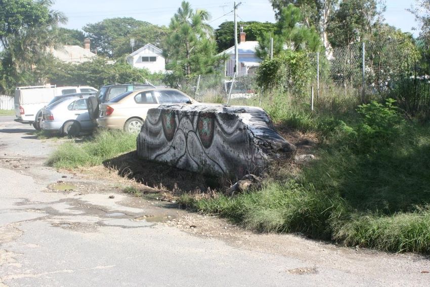
1.5 Ownership

The site is owned by Transport for NSW and managed by John Holland Rail – CRN.

1.6 Terminology

The terminology in this report follows definitions presented in The Burra Charter. Article 1 provides the
following definitions:

          Place means site, area, land, landscape, building or other work, group of buildings or other
          works, and may include components, contents, spaces and views.

          Cultural significance means aesthetic, historic, scientific, social or spiritual value for past,
          present or future generations.

          Cultural significance is embodied in the place itself, its fabric, setting, use, associations,
          meanings, records, related places and related objects.

          Places may have a range of values for different individuals or groups.

          Fabric means all the physical material of the place including components, fixtures, contents,
          and objects.

          Conservation means all the processes of looking after a place so to retain its cultural
          significance.

          Maintenance means the continuous protective care of the fabric and setting of a place, and
          is to be distinguished from repair. Repair involves restoration or reconstruction.

          Preservation means maintaining the fabric of a place in its existing state and retarding
          deterioration.

          Restoration means returning the existing fabric of a place to a known earlier state by
          removing accretions or by reassembling existing components without the introduction of new
          material.

          Reconstruction means returning the place to a known earlier state and is distinguished from
          restoration by the introduction of new material into the fabric.

          Adaptation means modifying a place to suit the existing use or a proposed use.

          Use means the functions of a place, as well as the activities and practices that may occur at
          the place.

          Compatible use means a use that respects the cultural significance of a place. Such a use
          involves no, or minimal, impact on cultural significance.

          Setting means the area around a place, which may include the visual catchment.

          Related place means a place that contributes to the cultural significance of another place.

EXTENT HERITAGE / Byron Bay Bus Interchange Redevelopment – STATEMENT OF HERITAGE IMPACT                 2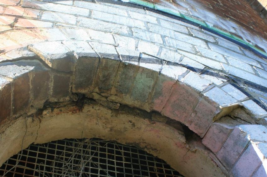
2 SITE
2.1 Location

The land which is the subject of this report is a part of Byron Bay Railway Station and is located
between the Railway Station and Butler Street, Byron Bay. It is part of Lot 4729, DP1228104. This
area is referred to in this report as the ‘Loco Siding’ area.

   Figure 1.            Red outline on map indicating the location of the Loco Siding area at Byron Bay
                                        Railway Station (Source: LPI SIX).

 Figure 2.           Red outline on Aerial Photo indicating the location of the Loco Siding area at Byron
                                     Bay Railway Station (Source: LPI SIX).

EXTENT HERITAGE / Byron Bay Bus Interchange Redevelopment – STATEMENT OF HERITAGE IMPACT                    3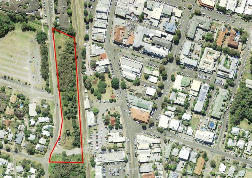
Figure 3.           Aerial Photo indicating the location of the key elements at Byron Bay Railway Station
                                                (Source: LPI SIX).

EXTENT HERITAGE / Byron Bay Bus Interchange Redevelopment – STATEMENT OF HERITAGE IMPACT                    4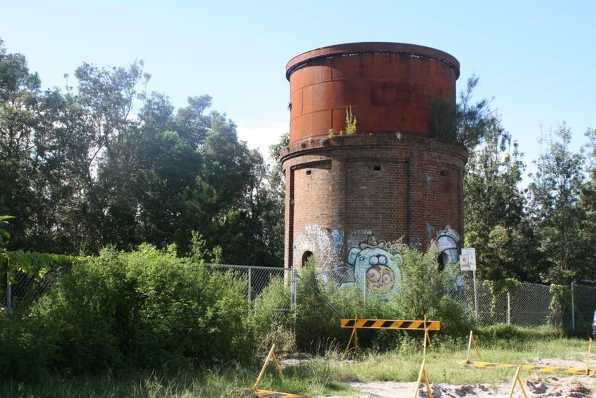
3 LISTINGS AND CONTROLS
3.1 Statutory Listings
3.1.1     Environment Protection and Biodiversity Act 1999
The site is not included on the National Heritage List under the Environmental Protection and
Biodiversity Act 1999.

3.1.2     NSW Heritage Act 1977
State Heritage Register
The site is included on the State Heritage Register (SHR) as Byron Bay Railway Station and yard
group (Item 01107). The statutory curtilage is contained within Lot 4729, DP1228104 and is shown
below in Figure 3.

 Figure 4.            The SHR curtilage for Byron Bay Railway Station and yard group, shown within the
                                          red boundary. (Source: OEH).

State-Agency Heritage and Conservation Registers
Section 170 of the Heritage Act requires all State-Agencies to maintain a Heritage and Conservation
Register, listing all places and items under their control that are recognised as having heritage
significance. RailCorp is a State Agency and Byron Bay Railway Station and yard group is included in
the RailCorp Heritage and Conservation Register. In recent years, reorganisation of the NSW Railway
system has seen the separation of various parts of the network into separate operating divisions,

EXTENT HERITAGE / Byron Bay Bus Interchange Redevelopment – STATEMENT OF HERITAGE IMPACT                 5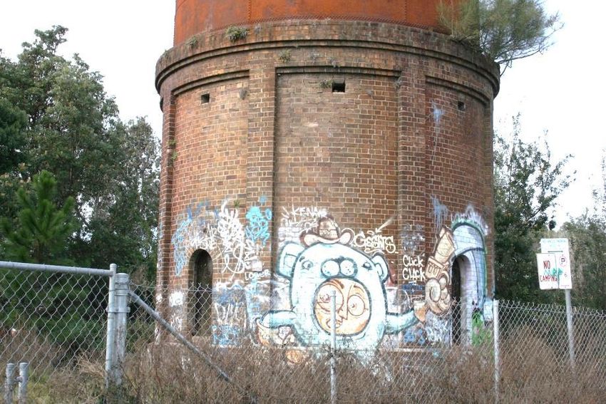
under the control of Transport for NSW. In 2011, the part of the network that includes Byron Bay
Railway Station was transferred to the Country Regional Network (CRN).

The Country Regional Network (CRN) is owned by Transport for NSW and is operated and
maintained by a commercial rail infrastructure manager, John Holland Rail (JHR), under a 10-year
contract that commenced in January 2012.

3.1.3     Local Environmental Plan
Schedule 5 - Environmental Heritage of the Byron Local Environmental Plan 2014 includes the
following items relating to the Byron Bay Railway Station site:

                Item                          Address                     Property ID         Signific     Item No.
                                                                                                ance
Former railway water tower               Butler Street            In road reserve adjacent    Local       I064
                                                                  to railway line
Cottage                                  60 Butler Street         Lot 10, DP 1027557          Local       I065
House including brick pier               62 Butler Street         Lot 11, Section 34 DP       Local       I066
fence mouldings                                                   758207
Byron Bay Visitors Centre                Jonson Street            Lot 1, DP 827049            Local       I072
Cottage                                  86 Jonson Street         Lot 1, DP 1001454           Local       I077
Railway station                          86 Jonson Street         Lot 1, DP 1001454 and       State       I078
                                                                  adjoining railway land

The Railway Station is also within or adjacent to two Heritage Conservation Areas.

          Name of heritage conservation area                        Identification on Heritage Map     Significance
Burns Street Conservation Area                                    Shown edged heavy red,              Local
                                                                  hatched and marked C002
Railway precinct, Byron Bay Conservation Area                     Shown edged heavy red,              Local
                                                                  hatched and marked C004

These Heritage Conservation Areas, along with the identification of individually-identified items, are
shown in the Byron LEP Heritage Map 03CC. The relevant extract from this map is shown in Figure 4
below.

It is relevant that the specific area of Byron Bay Railway Station land between the railway tracks and
Butler Street, i.e. the area containing the Water Tower, is outside of the boundaries of both
Conservation Areas.

EXTENT HERITAGE / Byron Bay Bus Interchange Redevelopment – STATEMENT OF HERITAGE IMPACT                              6
Figure 5. The Heritage Map for Byron Local Environmental Plan 2014 (Source: Byron Shire
Council).
3.1.4 Byron Development Control Plan 2013
In 2014, the Byron Shire Development Control Plan 2014 (Byron DCP 2014) was gazetted to control
development in the Byron Council area. Chapter C1 addresses the management of Non- Indigenous
Heritage in Byron Shire. The DCP does not identify any additional heritage items, relying on the items
listed in the LEP. It does provide design objectives and standards for assessment of proposed works
to or in the vicinity of heritage items and heritage conservation areas.
EXTENT HERITAGE / Byron Bay Bus Interchange Redevelopment – STATEMENT OF HERITAGE IMPACT 74 HISTORIC CONTEXT
4.1 Byron Bay - Indigenous Background.
When the far North Coast was first entered by Europeans, the area around Byron Bay and the
Brunswick River was the land of the Arakwal people, one of the tribes of the Bundjalung Nation whose
traditional country extended along the east coast between the Clarence River in New South Wales
and the Albert River region in southern Queensland and west to the Great Dividing Range. Arakwal
country extends from Seven Mile Beach south of Broken Head to the Brunswick River up north, out to
1
the escarpment west of Byron Bay and east out into the Tasman Sea . Byron Bay (‘Cavenbah’) was
an important meeting place for the Arakwal, neighbouring clans and people of the Bundjalung
nation. Cape Byron was ‘Walgun’. Other tribes travelled to Arakwal country to spear and trap fish
during the mullet runs up the coast.
However, with the arrival of the cedar-getters in the late 1850’s and the passing of the Crown Lands
Alienation (Settlement) Act in 1861, the Arakwal world changed dramatically. In the 1880’s the first
European settlers claimed and cleared land, which was now regarded as individually and exclusively
owned. Forests were replaced by grass or crops and native animals were replaced by cattle and
sheep. Arakwal families continued to live in the area but, by the late 1800’s, Arakwal people found it
2
increasingly difficult to use their country and their traditional way of life collapsed.
Figure 6. Extract of the Aboriginal Nations map, showing the Bundjalung lands on the far
North Coast of NSW (Source: https://aiatsis.gov.au)
1
http://arakwal.com.au
2
http://byronbayhistoricalsociety.org.au/history-trail/
EXTENT HERITAGE / Byron Bay Bus Interchange Redevelopment – STATEMENT OF HERITAGE IMPACT 8The NSW Aborigines Protection Board was established in late 1883 and, amongst other actions,
created Aboriginal Reserves, forcing Aboriginal people to relocate to these places. An Aboriginal
reserve was set aside in the vicinity of today’s Island Quarry, on the Ewingsdale Road, in 1880 and
another in 1890 on part of what is now the Byron Bay golf course. Another reserve was established
west of Tallow Creek, enduring from 1908-1924. Larger reserves existed at Ballina and at Cabbage
3
Tree Island in the Richmond River .
From the 1960s, Aboriginal people, including the Bundjalung, have achieved recognition as citizens
and of their rights as prior owners of the lands now occupied by Europeans. In 1985, a 16 hectare
section of the southern part of Goanna Headland, near Evans Head, became the first Aboriginal land
4
grant in New South Wales . The major part of Goanna Headland is now a reserve which is managed
for the wider community by the Dirawong Trust. In 2007, the Bundjalung achieved Native Title
recognition over an area of about 2,750 square kilometres, from Evans Head north-west to Casino,
inland to Busby Flats and south to Junction Hill near Grafton.
Figure 7. Arakwal Country extends from Seven Mile Beach south of Broken Head to the
Brunswick River up north, out to the escarpment west of Byron Bay and east into the Tasman Sea.
(Source: Arakwal People of Byron Bay- http://arakwal.com.au/about-us/)
3
http://nma.gov.au/blogs/inside/files/2011/02/connectkin_guide1.pdf
4
https://en.wikipedia.org/wiki/Bundjalung_Nation_Timeline
EXTENT HERITAGE / Byron Bay Bus Interchange Redevelopment – STATEMENT OF HERITAGE IMPACT 94.2 European Colonisation
5
Between 1828 and 1860 , European cedar cutters and a very small number of pioneer settlers
became active in the far north coast area but the Byron Bay area remained largely untouched by
development. A government reserve around the Cape Byron area was identified on a map in 1861, a
month before the lands in the surrounding districts were opened for free selection under the Crown
Lands Alienation Act 1861. This reserve wasn’t surveyed on the ground until 1881, when surveyor C
F Napier North also surveyed the first conditional land purchases at the same time.
Until the 1880s, transport and commerce with settlements to the south was based on a small landing
area at the mouth of the Brunswick River, with a cedar getters camp at Brunswick River recorded in
1849. A track developed between Lismore and Brunswick River (Brunswick Heads) during the 1860s,
the alignment following today’s Eureka, Federal and Goonengerry Roads through Mullumbimby to the
coast. However, the mouth of the Brunswick River was a difficult landing place and, in the early
1880s, the NSW Harbours and Rivers Department pursued a plan to develop the Byron Bay area as a
shipping locality. The first official government land sales at Byron Bay were held in 1881 and, in 1884,
a government surveyor had laid out a town plan for the village of ‘Cavvanba’. The NSW Government
co-incidentally allocated funding for the construction of a public jetty at Byron Bay in 1884. Sales of
land took place from 1886 and construction of the government jetty commenced the same year.
Figure 8. The SS Orara at Byron Bay Jetty c 1910 (Source: EJ Wright Collection #274 –
Richmond Tweed Regional Library)
5
This section is summarised predominantly the information provided in Byron Bay Historical Society website:
byronbayhistoricalsociety.org.au, and Weir Philips Heritage, Byron Bay Railway Station Conservation Management Strategy,
2018.
EXTENT HERITAGE / Byron Bay Bus Interchange Redevelopment – STATEMENT OF HERITAGE IMPACT 10The decision to develop the jetty demonstrated that, while there may have been little settlement, the
Government in Sydney was interested in the establishment of a serviceable port area to aid the
commerce of the region and attention had settled on Byron Bay, on the north side of Cape Byron. In
1883, Captain Frederick Howard, a Nautical Surveyor in the Department of Harbours and Rivers,
made an examination of the bay and expressed the opinion that Byron Bay was ‘well fitted to become
the port of this district, and, if facilities for shipping were given, would soon become an important
place’.
The jetty opening occurred in July 1888 and, the same year, the decision was made to build a branch
line from the Great Northern Railway, from Lismore to the Tweed River at Murwillumbah. The opening
of this railway line in 1894 had a profound effect on the pattern of settlement within the area. In
particular, the railway catapulted Byron Bay from a small seaside village to an industrial and port
town. The railway station itself was named Byron Bay and the name of the village was changed in
1894 to match.
The railway provided a reliable link between the agricultural hinterland and the seaport and facilitated
the reliable export of local products. It was provided with goods sidings which included a rail
connection to the Jetty, with horses and, later, steam shunting engines transferring goods between
the jetty and the railway station sidings. The timber industry remained an important activity in the
district, with attention turning from cedar to the other native forest trees, such as Ironbark and
Turpentine. However, the timber industry was dwindling and, by the turn of the century, was of minor
importance.
Dairy farming in the hinterland of the Far North Coast was responsible for opening the district to
settlement, and this, together with the development of large-scale refrigeration, enabled the marketing
of dairy products from the North Coast region throughout Australia and to the British butter market.
The North Coast Fresh Food and Cold Storage Co-operative Company butter factory opened in 1895
in Byron Bay alongside the railway line and soon became the major industry at Byron Bay. The
factory added pork and smallgoods processing and, by 1939, employed 350 people. A meat cannery
opened in the 1912 at Belongil and, after a fitful start, became a significant local industry.
Figure 9. The Byron Bay NORCO Factory in 1947, located south of the railway station (Source:
SLNSW)
EXTENT HERITAGE / Byron Bay Bus Interchange Redevelopment – STATEMENT OF HERITAGE IMPACT 11Figure 10. Jetty goods sidings at the north end of Jonson Street, circa mid-1920s - The level
crossing gates are at Lawson Street and the Water Tower in in the centre background (Source: EJ
Wright Collection #226 – Richmond Tweed Regional Library)
The township of Byron Bay was at its most prosperous between 1900 and 1928, when grand hotels
were built, dining and amusement parlours were popular, the railway provided a comfortable form of
local transport and the Literary Institute provided a library, films, and a venue for community
organisations and recreational clubs. A police station, courthouse and Post Office were added and a
number of banks were established.
The wreck of the SS Wollongbar at the Jetty in 1921 highlighted the deficiencies of this now aged
structure and a new jetty was constructed at Belongil, completed in 1928. The old jetty remained as a
popular fishing pier until its removal in 1948. The old jetty goods sidings evolved into the present day
Lawson Street carpark.
The second half of the twentieth century brought many changes to Byron Bay. The (new) jetty was
destroyed by a storm in 1954, coinciding with the collapse of the coastal shipping industry, and the
growth of the trucking industry and the spread of private car ownership saw the decline in the
importance of the railway. Newer industries, including sand mining and whaling, came and went but,
by the 1970s, changing economics saw the closure of the Norco factory and the meat processing
works followed in 1983. As the old industries were waning, though, Byron Bay was discovered by the
tourist and holiday industry as well as the ‘alternative life-stylers’ and the tourists, holiday-makers,
surfers, hippies and environmentalists created a new economy.
By the 2000s, Byron Bay was again a thriving town, with a services-based economy and high land
prices. This new economy has generated new tensions between residents, visitors and investors, with
considerable pressure to develop the land balanced by strong desires to protect the qualities that
underlie the attractiveness of the area.
EXTENT HERITAGE / Byron Bay Bus Interchange Redevelopment – STATEMENT OF HERITAGE IMPACT 12Figure 11. Byron Bay, looking east from the Jetty sidings to the intersection of Bay and Jonson
Streets, circa 1920s (Source: EJ Wright Collection #224 – Richmond Tweed Regional Library)
4.3 Byron Bay Railway Station
As the primary industries of Byron Bay expanded and changed, the local railway network adapted to
these changes. These began in 1898 and started with the addition of a fireman’s cottage. Shortly
after, in 1900, the creamery siding was extended and the goods siding was converted to a crossing
loop. In 1904, a suite of new works followed which included the replacement of the original 40-foot
turntable with a 50-foot turntable, the addition of a new water tank and sidings and a Station Master’s
house for the newly appointed Station Master. By 1906, a refreshment room, lamp room and ‘Out-of’
shed were added to the station precinct and the creaming siding was once again extended.
Figure 12. Byron Bay station circa 1896. Note the rail track is at building level and the
Refreshment Room has not been added. (Source: NSW Railway Archives; reproduced in Byways
of Steam, op cit).
EXTENT HERITAGE / Byron Bay Bus Interchange Redevelopment – STATEMENT OF HERITAGE IMPACT 13By 1908, the railway station required two porters, two junior porters, a gatekeeper and a Station
Master. Apart from the operation of a frequently-used network of sidings and the goods lines to the
jetty, station staff also undertook the day-to-day maintenance of the station and its facilities. On the
night of 13 September 1908, a fettler noticed flames coming from the Refreshment Room kitchen and
notified the Stationmaster in his nearby house. The Stationmaster punctured the adjacent water tanks
with a reaping hook and the water extinguished the fire. A railway engineer, Mr Watson, noted that the
6
damage had been restricted to about £20. A fire was also quickly extinguished in similar
circumstances in 1914.
In 1914, a major improvement program was commenced. A notable part of this work was the
construction of a platform of 194 metres (210 yards) long and 4.5 metres (15 feet) wide in front of the
station buildings. The platform was to improve passenger amenity at the station by allowing
passengers into carriages without using step ladders. The platform had a brick retaining wall with
concrete coping and was paved with blue-metal gravel. The works were designed to minimise the
impact to traffic schedules and, rather than realigning the station, the floors were lifted and the walls
of the original buildings were raised to suit the height of the new platform. A new parcel room was
constructed and the Refreshment Room was extended to nearly twice its former length, with a kitchen
and yard added. The water column for supplying engines was relocated to between the lines, to
7
enable its use by locomotives on either of the two lines.
Figure 13. Passengers leaving the Byron Bay station circa 1915. Note the Refreshment Room on
the left and the Water Tower in the background. This picture also shows the Alcorn monument in
the left foreground. (Source: EJ Wright Collection – Richmond Tweed Regional Library).
6
Grafton Argus and Clarence River General Advertiser; 17th September 1908; ”Fire at Byron Bay”, p.2.
7 Northern Star; 26th April.1915, “Railway Improvements”, p.3.
EXTENT HERITAGE / Byron Bay Bus Interchange Redevelopment – STATEMENT OF HERITAGE IMPACT 14Figure 14. Similar to Figure 15, in this view, the horse traps have been replaced by motor cars
and telegraph poles have appeared. There is an extra section on the southern end of the
Refreshment Room on the left (Source: EJ Wright Collection – Richmond Tweed Regional Library).
Throughout the 1920s and 1930s, a series of precinct improvement works were undertaken, typically
aimed at improving the look and surrounds of the station. In 1920, at the request of local residents,
the Railway Department provided a park rail fence for a division between the entrance gate and the
signal cabin. They also supplied topsoil for the shallower portions of the site, to level out the precinct.
The Department also provided timber sleepers and wire for a fence to divide the station from nearby
8
swamp land, though these were to be erected by local residents. In 1927, the newly appointed
Stationmaster, Mr G. Harris, took to installing garden beds and planting Pepper trees and Willows
along the lines, in an effort to improve the look of the station. Following this, the railway department
dispatched fifty plantings to Byron Bay.
In the 1950s, the North Coast Line became one of the earliest to convert to all-diesel locomotive
operations. By the early 1960s, there were no steam engines in use on this line (apart from rare
Vintage Excursion trains). At Byron Bay, this rendered the loco siding, including the coal stage, ash
pit, water tower and turntable obsolete. By 1956, the water jib had been removed from the water
9
tower. The water column was likely removed from the track area at the same time.
The station continued in operation until May 2004, when the last rail service from Casino to
Murwillumbah was discontinued and the line, and the station, closed permanently. The
Stationmaster’s House was restored and transferred to the Local Council. It now serves as the Byron
Bay Visitor Information Centre. The main station building itself is vacant but the former Refreshment
Room continues to operate as a licensed bar known as the ‘Railway Friendly Bar’.
8
Tweed Daily, 5 August 1920 ‘Improvements at Byron Bay Station’, p.2
9
Plan 40013 – Department of Railways - Byron Bay Water Service 3/12/1935 – amended 1951 & 1956.
EXTENT HERITAGE / Byron Bay Bus Interchange Redevelopment – STATEMENT OF HERITAGE IMPACT 15Figure 15. The south end of Byron Bay Station in 1929, with the Water Tower in the background.
(Source: C Henshaw - Museums Victoria Item- MM 8739).
Figure 16. Passengers at Byron Bay station in the 1930’s. (Source: EJ Wright Collection #1055 –
Richmond Tweed Regional Library).
EXTENT HERITAGE / Byron Bay Bus Interchange Redevelopment – STATEMENT OF HERITAGE IMPACT 16Figure 17. Captain Cook Bicentenary Special Train, hauled by Loco 1243 (176), passing through
Byron Bay in 1970. Note the Water Tower in the background, served by the inclined loco siding
(Source: EJ Wright Collection – Richmond Tweed Regional Library).
4.4 The Loco Siding Area
4.4.1 General Arrangement
Byron Bay Station was established with a Loco Service siding on the western side of the main line,
equipped with a Water Tower, coal stage, ash pit and turntable. These elements were all necessary
for refuelling and replenishing the water tanks for steam locomotives.
The siding was accessed along a single line of straight track, branching south-west from the main line
approximately 100 metres north of the station buildings. The track terminated approximately 15
metres south of the turntable used to reverse the locomotive. The water tower and coal stage were
situated on either side of the track, with the ash pit located between and below the tracks.
Later, the Loco Siding was also used for loading and unloading live animals; usually pigs, onto
wagons. A stockyard and ‘race’ were erected on the western side of the siding. Early plans show the
stockyard and race on the south side of the turntable (see Figure 19). Later plans and photographs
show the stockyard and race on the north side of the water tower (See Figures 20 and 21).
EXTENT HERITAGE / Byron Bay Bus Interchange Redevelopment – STATEMENT OF HERITAGE IMPACT 17Figure 18. Extract from the General Arrangement plan of 1892, showing the turntable, ash pit
and coal stage. (Source: ARHS – reproduced in Weir Phillips; Byron Bay Station and Yard Group
Conservation Management Strategy; 2018).
Figure 19. Extract from Byron Bay Station Plan circa 1914, showing the Loco Siding and the
layout of water tower, turntable and coal stage. Pig pens and a fenced race are shown on the
western side, south of the turntable. (Source: Sydney Trains).
EXTENT HERITAGE / Byron Bay Bus Interchange Redevelopment – STATEMENT OF HERITAGE IMPACT 18Figure 20. Extract from the Byron Bay Station Track Diagram, circa 1926, showing stockyard
and race located on the north side of the water tower, as illustrated in Figure 21. (Source: ‘Byways
of Steam’ op cit).
Figure 21. Pigs being loaded onto a train at Byron Bay circa 1930s. This view is from the vicinity
of Butler Street, with the visible wagons standing on or near to the turntable. Note the timber
fencing and ramp. (Source: J. Hackett via Byron Shire News 12/06/2016).
EXTENT HERITAGE / Byron Bay Bus Interchange Redevelopment – STATEMENT OF HERITAGE IMPACT 194.4.2 The Turntable
The turntable at Byron Bay was initially a 12.2 metre (40 feet) diameter standard locomotive turntable,
replaced with a larger 15.2 metre (50 feet) diameter turntable in 1904. Depending upon local
conditions, turntables were typically mounted in a pit, approximately 1 metre deep, with brick or
concrete side walls. In some cases, the outer wall of the pit was reinforced with concrete.
The turntable was comprised of a pair of fabricated iron plate girders, attached to a central cast iron
pivot frame, turning on the pivot mount which was fixed to a concrete footing in the centre of the
earthen floored well. The girders carried two heavy timber beams which were fixed to the track.
Support wheels attached to the outer ends of the girders ran on a circle of rail fixed to short sleepers.
No photos of the Byron Bay turntable have been identified, however, it was one of several built to the
same design along the Lismore to Tweed Railway Line and later replaced with a larger sized turntable
in the early twentieth century. The turntable at Byron Bay is believed to have been removed in the
1960s.
Figure 22. Murwillumbah railway turntable in 1904, showing the original 40ft turntable
arrangement. This turntable, like Byron Bay, was replaced with a larger type in the early twentieth
century. (Source: Tweed Library: MUS2015.60).
Figure 23. Murwillumbah’s 60ft railway turntable circa 2005. Note the lowered side walls and
concrete wings below the railway track at either end. (Source: RailNet).
EXTENT HERITAGE / Byron Bay Bus Interchange Redevelopment – STATEMENT OF HERITAGE IMPACT 204.4.3 The Coal Stage
The Coal Stage was a standard-design timber coal stage, which was a timber platform with three
sides (the open side fronting the track), carried on short timber posts. The Coal Stage at Byron Bay
was 18.9 metres (61.5 feet) long and 3.9 metres (12.5 feet) wide, carried on seven rows of three
posts. Each row of posts was founded upon a timber tie beam, with each post connected into the tie
beam with a mortise and tenon. The platform, sheeted with 228 millimetres (9 inch) wide and 76
millimetres (3 inch) thick butted boards, was set at a height of 1.2 metres (4 feet) above rail level. The
Coal Stage is believed to have been demolished in the 1960s.
Figure 24. Drawing: “Coal Stage at Cavvanba”, circa 1892, showing the structure of the coal
stage at Byron Bay Station. (Source: Sydney Trains).
4.4.4 The Ash Pit
Ash pits were provided at every locomotive service point throughout the NSW railway system. Also
known as Engine Pits, ash pits were typically a rectangular brick-lined pit located below and between
the rails, approximately 6.1m (20 feet) long, 1.2m (3.5 feet) wide and 1.5m (5 feet) deep. One end
was usually given steps down from ground level. No photos of the Byron Bay ash pit have been
identified. It is believed to have been buried in situ (or removed) in the 1960s.
EXTENT HERITAGE / Byron Bay Bus Interchange Redevelopment – STATEMENT OF HERITAGE IMPACT 21Figure 25. Ash Pit surviving and exposed at Bombala railway station. (Source: P. Buckley;
http://sydneyrailwaystations.wordpress.com/).
4.4.5 The Water Tower
The Water Tower at Byron Bay was erected in 1894 and comprises a cylindrical wrought-iron (or
steel) tank with a capacity of 20,000 gallons standing on a cylindrical brick masonry tank stand. The
tank consisted of three rings of riveted plates, each made up of seven panels of curved wrought iron
plates. The brick tank stand was provided with windows and a door and provided storage under the
tank.
Figure 26. Byron Bay Railway Station in the 1970s, viewed from the south-western (Butler St)
with the water tower in the foreground. Note the cleared and level nature of the Loco Siding area.
(Source: EJ Wright Collection – Richmond Tweed Regional Library).
EXTENT HERITAGE / Byron Bay Bus Interchange Redevelopment – STATEMENT OF HERITAGE IMPACT 22Figure 27. Photo showing a steam locomotive watering from the water-column located between
the tracks at the south end of Byron Bay Station. (Source: J L Buckland, reproduced in ‘Byways of
Steam 18’ op cit).
The water tank supplied water to an outlet pipe mounted on the side of the brick tower base, serving
locomotives on the adjacent siding. Another pipeline led to a water crane located at the southern end
of the station platform, between the main line and the passing loop. The water tower operated until
the removal of steam locomotives from the Line in the 1950s. It is believed that the window frames
and door were removed from the water tower in the 1960s.
4.5 Byron Bay Railway Water Supply Arrangements
The water supply arrangements for Byron Bay Railway Station are shown in Figures 28, 29, 30 and
31 below. Archival plans do not always accurately reflect the arrangements as they may have been
built and documentary records may not always be complete.
Figures 28 and 29 are contemporary (both pre-date the opening of the station) and reflect the original
(or planned, at least) water supply arrangements. The water tank was filled by a small self-contained
steam pumping plant drawing from a well sunk into the ground and delivering through an underground
103 millimetres (4 inch) diameter cast-iron pipe. The water tank supplied water to a 231 millimetres (9
inch) diameter cast-iron pipe running eastwards underground to a water crane (or ‘water column’)
located at the southern end of the Byron Bay Station Platform (on the eastern side of the Main Line).
The well is shown to be 14.2 metres (46 feet) (centre of tank to centre of well) from the water tank,
with the pump house located approximately 6.2 metres (20 feet) from the water tower brick wall. The
direction of the pipework shown in the plan suggests that the well and pumping hut were located to
the east of the water tower. No other drawings or plans suggest that this arrangement was enacted.
EXTENT HERITAGE / Byron Bay Bus Interchange Redevelopment – STATEMENT OF HERITAGE IMPACT 23Figure 28. Extract from the General Arrangement plan of 1892, showing the turntable, ash pit,
coal stage and 9 inch pipeline to a water column at the south end of the platform (Source: ARHS –
reproduced in Weir Phillips; op cit).
Figure 29. Pumping Engine House at ‘Cavvanba’ (corrected to “Byron Bay”), circa 1890,
showing the water tower supplied from a well via a small steam pumping plant. The plan states
that there is 45 feet between the centre of the tank and the centre of the well. (Source: Sydney
Trains).
EXTENT HERITAGE / Byron Bay Bus Interchange Redevelopment – STATEMENT OF HERITAGE IMPACT 24Figures 30 and 31 are contemporary and date from the mid-1930s. Figure 30 dates from 1934 and,
while it is a ‘signals’ diagram, it shows a ‘pump house’ located between the loco siding and the main
railway line (noting also that the water tower is not shown in this plan). The distance between the
centre of the water tower and the location of the pump house in this plan is approximately 33.9 metres
(110 feet). For this reason, it seems unlikely that this is the same pump house shown in Figure 29 (if
that was, in fact, ever built).
Figure 31 is a water service diagram and shows that water supply to the tank is obtained from a
103mm (4 inch) pipe coming from a dam 923 metres (3000 feet) away. This dam is shown as a 20.3
metres x 46.2 metres x 6.2 metres (66 feet x 150 feet x 20 feet) deep rectangular ‘dam’ located on the
south side of Carlyle St, with the measured distance indicating a location in the vicinity of Massinger
Street. The pump house is located adjacent to the dam. There is no indication of the means for filling
this dam. In this context, then, the purpose of the pump house shown in Figure 30 is unknown (unless
it represents a situation that predates the operation of the Carlyle St dam). It is also speculated that
the kink shown in the course of this pipeline, east of the water tower, may indicate the location of the
original pump house and well.
Figure 30. Extract from Byron Bay Signal Layout plan circa 1934. This plan shows a pump
house between the station and the Loco Siding, although the dimensions do not match those
shown on the original plan in Figure 42 above. (Source: Sydney Trains).
Figure 31 also shows that water is still delivered to the water crane via a 231mm (9 inch) underground
pipe, however, the station platform appears to have been extended southwards and, as a
consequence, the water crane has also been moved southwards. The 231 millimetre (9 inch) pipe
from the water tank connects to a transverse 231 millimetre (9 inch) pipe laid between the railway
tracks running southwards approximately 30.8 metre (100 feet), with the water crane standing
between the Main Line and the Loop Line (see also Figure 27). This plan also indicates that there was
a water ‘jib’ attached to the side of the water tower, for supplying locomotives parked on the loco
siding. An annotation on Figure 31 indicates that this jib was removed in 1956.
EXTENT HERITAGE / Byron Bay Bus Interchange Redevelopment – STATEMENT OF HERITAGE IMPACT 25Figure 31. Extract from Byron Bay Water Service Drawing - 3/12/1935, showing the Loco Siding
with water tower, turntable, ash pit and coal stage. Note the water supply line to the water column
between the tracks at the south end of the station. Also note that supply is now obtained from a
3000 feet long, 4 inch diameter pipe along Carlyle Street from a dam. (Source: Sydney Trains).
4.6 Railway Water Tanks: 1892 - 1898
The early years of the NSW Railways, from 1855 to 1892, saw a range of water supply facilities used
10
to supply water to the steam locomotives. From the earliest years, when each situation was given a
tailored solution, two standard designs for railway water tanks evolved.
These early water tanks were rectangular, built up using wrought iron plates and were supported on
timber and brick or stone masonry stands; there were two types. The first was a ‘plate’ type, using
square buckled plates riveted to each other by joining strips, with internal steel rod bracing. The joints
between plates are expressed on the exterior by double rows of rivets between each plate. The
second type used flat plates with flanged edges which were riveted on the inside of the tank, leaving
little external evidence of the joints. Both types of tank had shortcomings, the most critical being that
they could not be increased in capacity, if required.
From the 1890s, the main (trunk) lines were largely completed and railway construction was largely
focussed on the construction and extension of branch lines in regional areas. Responsibility for the
design, construction and maintenance of new structures and facilities was transferred to the Public
Works Department (PWD) in 1888 but wasn’t fully in effect until 1892. This led to the redesign of
many of the standard structures, including station buildings, bridges and watering facilities. The
10
The historical material for this part is summarised from previous report “Watering Facilities – Country Regional Network -
Heritage Planning and Conservation Planning Report” prepared by Extent Heritage Pty ltd for John Holland Rail; 2016.
EXTENT HERITAGE / Byron Bay Bus Interchange Redevelopment – STATEMENT OF HERITAGE IMPACT 26railway extension from Nyngan to Cobar in 1892 used entirely new water tank designs, one at Boppy
Mountain and the other at Cobar.
The new design, with a capacity of 20,000 gallons, was cylindrical and consisted of three rings, each
made up of seven panels of curved wrought iron plate standing on a cylindrical brick masonry tank
stand. The brick tank stand had windows and a door and provided storage on the underside of the
tank. In addition to Boppy Mountain and Cobar, other early examples were located at Brocklesby,
Corowa, Milsons Point, Springdale, Meranburn, Mandagery, Parkes, Forbes, Lismore and Byron Bay.
All but the Milson’s Point water tower remained in use until the end of steam locomotion.
Within a short time, a second, economical style of ‘round tank’ was developed. Constructed between
1894 and 1899, these tanks were basically the same as the first set but they no longer included the
architectural features present in the previous brick tank stands. This second style was used along
branch extensions in Murwillumbah, Carlachy, Condobolin, Warren, Finley and Yagobie.
At the end of the 1890s, economic and political circumstances led to a greater emphasis on economy.
From 1898 through to 1915, the PWD introduced a more economical design of water tank. Consisting
of a steel plate tank on a timber or steel frame, these tanks utilised standardised flanged plates that
could be bolted together in various patterns to increase or decrease the holding capacity. The tanks
also sat on new ‘T’ shaped brackets which simplified their attachment to the stands. The sizes of the
tanks ranged from 5000 to 15,000 gallons and were installed according to the requirements of the
line.
These water tanks were manufactured for lines extending to Koorawatha, Grenfell, Lockhart,
Brewarrina, Tarrion, Inverell, Holbrook, Mount Horeb, Tumut, Barmedman, Wyalong, Wee Waa,
Burren, Clearfield, Gurranang and Grafton. After 1915, there were few new railway constructions in
NSW and, consequently, little development in the design of water tanks. The stands became
universally fabricated from steel RSJs; a development that occurred owing to the commencement of
steel manufacture in NSW at Newcastle from 1915.
Figure 32. Early style of metal-plate water tank used on the NSW Railways (Source: Extent
Heritage).
EXTENT HERITAGE / Byron Bay Bus Interchange Redevelopment – STATEMENT OF HERITAGE IMPACT 27Figure 33. Later style of metal-plate water tank used on the NSW Railways (Source: Extent
Heritage).
Figure 34. Meranburn (L) and Murwillumbah (R) are the two surviving railway water tanks of this
type (Source: Extent Heritage).
EXTENT HERITAGE / Byron Bay Bus Interchange Redevelopment – STATEMENT OF HERITAGE IMPACT 285 PHYSICAL DESCRIPTION
5.1 The Loco Siding area
The Loco Siding area is a strip of land on the western side of Byron Bay Railway Station, between the
railway tracks and Butler Street. The land is vacant and overgrown with vegetation, the only visible
structure being the brick water tower in the south-western corner. The Byron Motor Lodge Motel is
located beyond the northern boundary and, to the south, the land is occupied by more substantial
native vegetation, merging southwards into the bushland of the Currumbin Swamp.
Figure 35. Aerial views of the Loco Siding area, in circa 2012 (left) and 2017 (right). Note the
growth of vegetation around the water tower (Sources: LPI Six (l) NearMap (r))
EXTENT HERITAGE / Byron Bay Bus Interchange Redevelopment – STATEMENT OF HERITAGE IMPACT 29The land is generally flat, with a gentle fall from the centre northwards into swampy ground. The
eastern side is bound by the embankment of the railway permanent way, which is approximately 1 – 2
metres below the level of the Loco Siding area. The western side is bound by a chain mesh fence
along the eastern side of Butler Street, the verge of which is used as public parking, predominantly
during daylight hours.
The southern end of the Loco Siding area is dominated by the informal side road off Butler St, which
provides additional car parking and terminates at the western side of the railway track reserve. A
fenced pedestrian pathway crosses the railway tracks at this point and this pedestrian level crossing
is an important and long-standing access route from one side of the railway line to the other. The
roadway is an old access road into the railway land and is not a gazetted road.
South of this roadway, the land is heavily vegetated and drops approximately 0.5 – 1 metre in height
and is consequently swampy as it collects the stormwater runoff from the surrounding lands.
Figure 36. The
Loco Siding area
viewed south-
eastwards from
Butler Street
Figure 37. The
Loco Siding area
viewed north-
eastwards from
Butler Street
EXTENT HERITAGE / Byron Bay Bus Interchange Redevelopment – STATEMENT OF HERITAGE IMPACT 30Figure 38. The
informal side road
leading to the
pedestrian crossing
of the railway
tracks
Figure 39. The
area south of the
side road is heavily
vegetated, low-
lying and swampy.
5.2 The Water Tower
The former railway water tower is a circular brick tower, 6.5 metres in height, surmounted by a riveted
wrought iron water tank of 6.4 metres diameter and 3.3 metres height. The brick tower has expressed
pilasters framing eight recessed panels, with a strong, simple cornice around the top. Every second
panel features a semi-circular arched opening, each with two rows of brick voussoirs, infilled with wire
mesh, with the one on the eastern side larger in dimensions to form a person opening.
The interior of the brick tower is empty, with only the base of the tank and the pipework visible
overhead. Exterior pipework is located on the eastern side, with the outlet pipe projecting through the
brickwork at approximately 4 metres above ground and the inlet pipe running from ground level up the
side of the tower and tank to the top of the tank.
The brickwork is generally in good condition except around the cornice, where vegetation has become
established in the mortar of the coping and between bricks. The iron plates of the tank are very
corroded, with many pinholes in the sides.
EXTENT HERITAGE / Byron Bay Bus Interchange Redevelopment – STATEMENT OF HERITAGE IMPACT 31Figure 40. The Water
Tower, seen from Butler
Street.
Figure 41. The Water
Tank on the top of the
brick tower has some
notable corrosion
issues
Figure 42. The brick
tower is generally in
good condition, except
where affected by
vegetation and metal
corrosion around the
top.
EXTENT HERITAGE / Byron Bay Bus Interchange Redevelopment – STATEMENT OF HERITAGE IMPACT 32Figure 43. The
underside of the water
tank and outlet piping
viewed from within the
brick tower. The tank
floor appears to be
relatively sound.
Figure 44. Brickwork
around the upper rim is
badly affected by
vegetation growth.
Figure 45. The metal
work of the tank already
shows evidence of
previous corrosion
repairs
EXTENT HERITAGE / Byron Bay Bus Interchange Redevelopment – STATEMENT OF HERITAGE IMPACT 33Figure 46. The floor
of the tank has become
largely detached from
the sides
Figure 47. The lower
flange attached to the
tank and the rendered
coping on the brickwork
were designed to shed
stormwater but both are
in poor condition.
Figure 48. Viewed
from above, the
corrosion of the tank
floor at the connection
to the tank walls is very
apparent. There is
vegetation growing in
the rust and debris on
the floor of the tank.
EXTENT HERITAGE / Byron Bay Bus Interchange Redevelopment – STATEMENT OF HERITAGE IMPACT 34Figure 49. The
corrosion of the upper
horizontal tank lip
appears more advanced
than corrosion of the
vertical surfaces.
Figure 50. The arch
brickwork of the
western window has
moved and one brick
has been crushed.
Figure 51. This
brickwork crack is
moving vertically
downwards and is
apparent on the inside
of the brickwork as well.
EXTENT HERITAGE / Byron Bay Bus Interchange Redevelopment – STATEMENT OF HERITAGE IMPACT 355.3 Other features
A number of other features and elements were identified on or in the ground within the Loco Siding
area. These are:
The circle of brick/concrete at ground level which is the top of the wall of the turntable pit;
The concrete slab pier on the north side of the turntable pit;
The large concrete slab pier on the southern side of the turntable pit, outside of the fence
within the side road;
A concentration of coal ash in the soil in the vicinity of the location of the ash pit; and
Scatters of old rail and remains of railway fence lines.
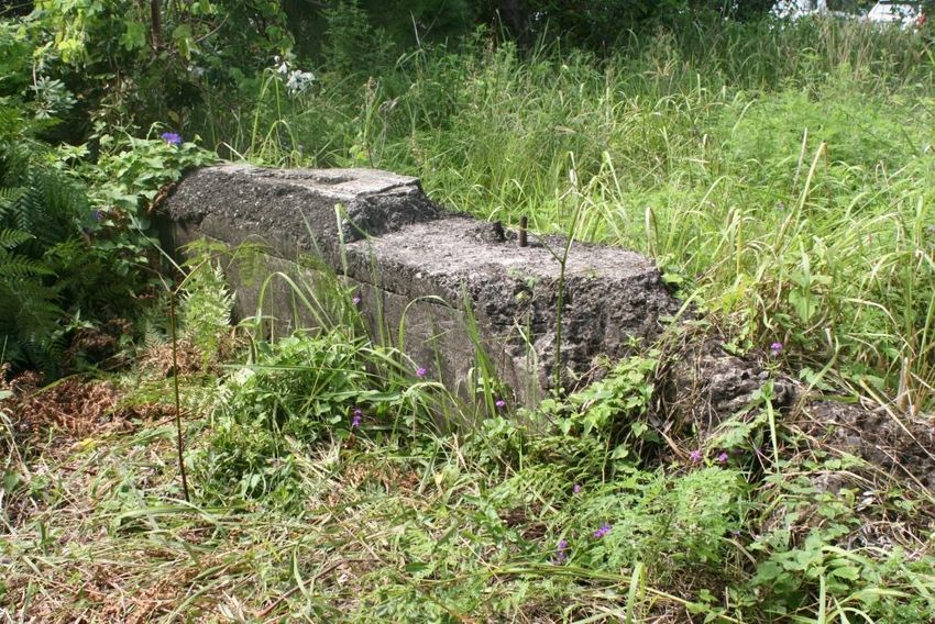
The turntable pit and concrete piers are related items, with the concrete piers supporting the railway
track where it crossed over the edge of the pit.
5.3.1 The Turntable Pit
The turntable was a 15.4 metre (50 foot) diameter railway turntable, comprising a central iron or steel
bridge revolving on a central pivot and an outer circular rail. In this case, the turntable was specifically
for the purpose of reversing the direction of locomotives and a single line of track approached the
turntable from the northern side. A short length of track is shown on drawings on the opposite (south)
side, provided as an end siding for flexibility on working the locomotives on and off the turntable.
The turntable bridge is missing and the pit has been filled with soil to its uppermost level, leaving only
a circle of bricks and concrete visible in the ground. (Note that, on some occasions, the pit floor was
on ground level, with the track set on an embankment.) Consequently, it is unknown what remains
within the pit. Typically, turntable pits had a slightly concave conical concrete floor with the pivot
bearing in the centre and an outer circular rail, which may be located on the floor or may be located
on a step on the outer wall. Figures 55 – 57 below illustrate different arrangements of turntable pits
used within the NSW railway system.
To support the weight of the locomotive, the railway track at the edges of the pit was supported by
sturdy piers. At Byron Bay, these piers are of mass concrete, approximately 2 metres long and 30 cm
thick, with the height above present ground level indicating that the track was carried on an
embankment which has subsequently been removed.
EXTENT HERITAGE / Byron Bay Bus Interchange Redevelopment – STATEMENT OF HERITAGE IMPACT 36You can also read