2021-2051 Infrastructure Strategy - Supporting documentation for the 2021-31 Long Term Plan Consultation Document - Say It Napier logo
←
→
Page content transcription
If your browser does not render page correctly, please read the page content below
2021-2051
Infrastructure
Strategy
Supporting documentation
for the 2021-31 Long Term Plan
Consultation Document
Contents
2021-2051                                                              1
Draft Infrastructure Strategy                                          1
1.     Executive Summary                                               4
     1.1 Context                                                       5
     1.2 Key Issues to be addressed                                    5
     1.3 Overall Vision for Council Infrastructure                     7
       1.3.1 What are the major projects?                              7
       1.3.2 What is the Cost?                                         8
2.     Introduction                                                    9
     2.1 Serving our Community                                         10
     2.2 Purpose of this document                                      12
3.     Introduction to Napier                                          13
     3.1.      Context                                                 13
       3.1.1 Location and Geography                                    13
       3.1.2 Climate                                                   13
     3.1.3     Population                                              13
     3.1.4     Natural Hazards                                         14
4      Key Assumptions                                                 15
     4.1       Growth                                                  15
       4.1.2     HPUDS Updated Projections and Forecasts 2015 – 2045   16
     4.2       Covid 19- Impacts                                       17
     4.3       Three Waters Reform                                     18
     4.4       Natural Hazards and Infrastructure Resilience           19
       4.4.1 Critical Infrastructure                                   20
     4.5       Climate Change                                          21
     4.6       Legislation Change                                      22
     4.7       Technology Change                                       22
     4.8       Asset Management Journey                                22
       4.8.1 Data Quality and Confidence                               23
5      Key Infrastructure Issues                                       24
     5.1       Our Infrastructure Teams                                24
     5.2       Key Infrastructure Issues                               25
     5.3       Themes / Summary/ Impacts and key projects to address   30
     5.4       Introduction to Water Supply Projects:                  31
     5.5       Introduction to Stormwater Projects:                    32
     5.6       Introduction to Wastewater Projects:                    33

                                                                        2
5.7    Introduction to the Transportation projects:                 34
    5.8    Introduction to the Parks and Reserves Projects:             35
    5.9    Plan on a Page: Infrastructure Programme of Work 2021-2051   36
6     Infrastructure Summaries                                          37
    6.1 Renewals Expenditure                                            38
                                                                        39
    6.2 Transportation                                                  39
    6.3 Three Waters                                                    45
    6.3.1 Drinking Water Supply                                         45
    6.3.2 Wastewater                                                    50
    6.3.3 Stormwater                                                    55
    6.4 Parks, Reserves, Sportsgrounds, Cemeteries and Public Toilets   59
      6.4.1 Sportsgrounds                                               61
      6.4.2 Cemeteries                                                  65
      6.4.3 Public Toilets                                              68
      6.4.4 Reserves                                                    70
    6.5 Building Asset Management                                       72

                                                                         3
1. Executive Summary
                                                                                   History of Napier Infrastructure
This Infrastructure Strategy covers the Council’s provision of
                                                                       Napier First Surveyed     1852
transportation, water supply, storm water, wastewater, parks
and reserves, and buildings                                                                      1857    First Main Road Built

Infrastructure is the area that oversees the physical assets that       Severe Earthquake        1863
the Council owns and maintains to deliver services to the
                                                                                                  1867    Ngaururoro River
community. This includes cemeteries, public bathrooms,
                                                                                                          Bridged
parks, sportsgrounds as well as the water network, roads that
are not state highways and buildings such as libraries,              Napier- Taradale Rd Built   1870
aquariums and theatres.                                                                           0
                                                                                                          Flood Destroys Napier
                                                                                                 1873
Infrastructure is the foundation upon which Napier is built;                                              - Taradale Road
                                                                      Constructed
without these fundamental assets the town could not function         Street Forming & Lighting
                                                                                                  1877
and flourish.                                                       (gas)
                                                                                                           Reservoir, pipeline &
                                                                                                  1883
What has happened since the last Long Term Plan …                                                          well completed (150,000
                                                                         Great  Fire (gas)
                                                                                     (26                   gallons / day)
                                                                          Lighting
                                                                         Buildings Destroyed)    1886
Since the last Long Term Plan our city has grown, and
development is occurring faster than expected. We have also                                                 Major Flooding (3/5 of
                                                                                                  1897
come together in the national fight to contain Covid 19 and                                                 Heretaunga Plains)
have experienced a one in 250-year flooding event that left                  Land donated for
                                                                                                 1910
many without habitable homes and stretched infrastructure                    McLean Park
                                                                                                           McLean Park
past its designed capacity.                                                                       1912
                                                                                                           Grandstand Built
On the heels of the Havelock North Water Crisis there has
                                                                            Electric Street
been a Three Waters review by the Government and we have                                          1915
                                                                            Lights
undertaken a chlorine free review. We have developed
                                                                                                  1931   Napier Earthquake
masterplans and strategies for the majority of our key
infrastructure and Council is reviewing and moving forward                   First Streets in
with these plans.                                                                                 1949
                                                                             Onekawa Sold
These events have changed the way we have viewed our
infrastructure, how we maintain and use it, and ultimately has                                    1950 Napier Proclaimed City

shaped the way that we have developed our infrastructure
strategy.                                                                  Anderson Park Land
                                                                                                  1962
                                                                           acquired.

                                                                                                 1964     Hawkes Bay
                                                                                                          Airport Opened
                                                                         New Outfall Pipeline-
                                                                         Awatoto                 1973

                                                                                                 1991    Miliscreen Plant
                                                                                                         Opened

                                                                               MTG Opened         2013

                                                                                                  2014   Biological Trickling Filter
                                                                                                         (Wastewater) Opened
                                                                    McLean Park Drainage &        2018
                                                                    Re-turf

                                                                                                                               4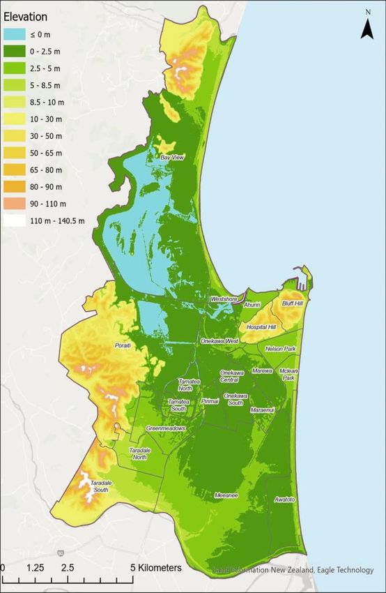
1.1 Context
Council provides various services to a community of around
25,000 households. The key infrastructure identified in this
strategy includes:

    -    Water Supply
                                                                                  Enabling Growth
    -    Wastewater

    -    Stormwater                                            Napier is a medium- high growth city with a requirement to
                                                               enable and provide affordable development under a
    -    Roads and Footpaths                                   National Policy Statement – Urban Development. This
                                                               external driver coupled with increased regional migration,
    -    Community Property
                                                               productive soil protection, low-lying risk prone land and a
    -    Parks and Reserves                                    small geographical area makes it a difficult balancing act to
                                                               provide for sustainable growth.
These assets contribute to the wellbeing and prosperity of     Council’s Response: Three major developments are
Napier city and have a combined value of around $2 Billion.    underway or planned in Napier. Council are delivering
                                                               properties through its own development - Parklands
                                                               Residential Estate. Te Awa is experiencing significant
                                                               development and infrastructure is going in now to support
                                                               this growth. The Mission development is progressing.
1.2 Key Issues to be addressed                                 Council is looking at how to encourage intensification
The internal and external landscape at Council has changed     through the District Plan Review.
significantly over the last three years since the last Long-
Term Plan. There are a number of major factors that
influence the decisions being made by staff, and elected
members, to enable service levels to be maintained and for
infrastructure to be kept at a level that compliance with
legislation is maintained in a changing environment. The
standards that are required, particularly in the Three                            Future Proofing
Waters Activities, are becoming more stringent and Council
                                                               Napier is moving from a small regional centre to a more
is planning for this.
                                                               modern, vibrant city. To support this change and to meet
                                                               increasingly stringent regulatory and environmental
                                                               guidelines whilst balancing risks around natural hazards and
                                                               climate change, the city needs to plan carefully to optimise
                                                               its investment in the future. Providing for this growth is a
Below are the nine Key Issues that have been identified for
                                                               large component of this strategy and the associated Long-
this Long-Term Plan period and the main actions required
                                                               Term Plan.
to address the issues:

                                                               Council’s Response: Ultimately Council wants to deliver
                                                               timely, robust infrastructure in a sustainable way. Part of
                                                               this involves detailed planning, which was the focus of the
                                                               last Long-Term Plan, now the teams are reviewing the long-
                                                               term master plans and prioritizing work to make our
                  Affordability                                infrastructure more resilient and compliant. Superimposed
                                                               on this is understanding the highest risk areas in the city and
Napier has historically operated with a very financially
                                                               various studies are underway with external parties to
prudent perspective combining low debt and minimised
                                                               understand the impact of natural hazards, evacuation
operational     spend.    With     increasing   regulatory
                                                               routes and what Infrastructure is required to support the
requirements and aging assets that require improved levels
                                                               community during an incident. Together, these pieces of
of operational and maintenance expenditure alongside
                                                               work, combined with climate change planning and growth
capital upgrades, this promotes a change in the operating
                                                               planning will assist Council to provide appropriate
ethos for both the Council and the community.
                                                               infrastructure that meets compliance and the city’s needs.
Council’s Response: Council is concentrating on maintaining
what we already have, including increasing allowances for
renewals and deferring a number of non-essential projects.

                                                                                                                             5
Capacity to Deliver and
                                                                                    Supporting Economic Recovery
                  Supporting Improved
                                                                The government is driving economic recovery through
                  Environmental Outcomes
                                                                stimulus packages. This will increase the number of
The environment sustains our city, is the cornerstone for       projects to be delivered, which results in additional
our tourism sector and the reason we love living here. There    workload and reporting requirements over a condensed
is a need to protect our natural resources in alignment with    timeframe. E.g., Shovel Ready Projects and Three Waters
cultural values. This promotes the need to focus on             Reform projects. Council has been delivering capital plans
supporting our Natural Heritage through meeting increased       over the last 4 years that range between $20 and $50m in
regulatory requirements, while working with the local           total. The projections for the latest Long-Term Plan
community and stakeholders collaborating to ensure that         significantly exceed this value (excluding stimulus
all of us are invested in improving outcomes.                   work) and given current staffing levels and potential
                                                                industry constraints there are hurdles to jump through to
Council’s Response: Over the last few years, Council has        ensure that Council can deliver the planned capital
been building an Environmental Solutions team of scientists     programme.
who are focused on improving the quality of our open
waterways and reducing the contamination of our                 Council’s Response: Council has a large amount of work to
stormwater network. This team and other infrastructure          deliver in a constrained industry with a lot of competition.
teams are working on projects such as: reduced leakage,         Council is working with other Regional territorial authorities
optimised water use on Parks and Reserves, fixing and           to see how we can work together to deliver these programs
replacing the wastewater outfall pipe, planning for             of work. This is already starting with five regional projects
increased requirements around wastewater treatment and          being delivered as part of the three waters reform. The
discharge. Longer term we are also going to store and treat     opportunity for Council is to encourage new players into the
stormwater at Lagoon farm, assisting with the quality of        Hawkes Bay market by reviewing our procurement
water going into the Estuary.                                   methods, bundling work together and also prioritising the
                                                                work that is most important to complete. Where Council
                                                                resources are stretched, we are looking at external
                                                                assistance where needed, for example where we need
                                                                additional technical expertise or project management
                                                                assistance.

                  Natural Hazards and Climate
                                                                                    Streamlining BAU Processes and
                  Change.
                                                                                    Data Quality

Until now, there has been no targeted approach to monitor       The Council is in a state of transition, moving from outdated
and address climate change, hazards management,                 models of working to embracing new technology and an
sustainability and the journey towards Carbon Zero. The         efficient future. The systems we use are outdated and no
next 30 years will see significant changes in these areas and   longer fit for purpose, which takes officer time away from
Napier needs to have sufficient resources to guide our local    delivering our services in the most efficient way and
direction, and a policy that is aligned with research and       optimising our operational capacity.
direction regionally and nationally. This will support the
delivery of appropriate infrastructure and provide for a        Having the appropriate tools, systems, processes and data
resilient and sustainable future.                               to understand our current state, the risks and
                                                                improvements required, will enable optimised decision
Council’s Response: In addition to the actions mentioned
                                                                making and reduce uncertainty and will deliver costs
above around understanding natural hazard risks and how
                                                                savings.
to manage these, the Council is focussing more closely at
energy use, optimising equipment, setting materials
                                                                Council’s Response: This is a high priority area that is being
standards and is moving towards reducing our Carbon
                                                                worked on by a number of teams. Leading up to this Long-
footprint.
                                                                Term Plan Council are investing in new computer systems,
                                                                one of which includes an upgrade of Council’s main Asset
                                                                Register. This is funded via the three waters reform
                                                                programme. An Asset Management Continuous
                                                                Improvement Plan (AMCIP) has been developed and this
                                                                will guide the Infrastructure related BAU processes.

                                                                                                                             6
Prioritisation of asset replacements and upgrades are taking
place to identify what is essential, and what is well utilised
along with what is affordable.
Preparing for Three Waters Reform
Programme
Council’s plan is to ensure that more money is set aside for
depreciation over the next 10 years and ensure that we are
Council is operating within an uncertain environment proactive in our management of upcoming renewals, rather
regarding the future of Water. The industry is undergoing than waiting for their end of life before attending to them.
major reform that may result in these services being
delivered at a regional or multiregional level. The objectives
of the reform are to provide everyone with more equitable
access to safe and affordable water and improved
environmental outcomes.
Napier has been provided with an initial $12.51m to work
towards meeting the reform objectives between November
1.3 Overall Vision for Council Infrastructure
2020 and March 2022. This will enable Council to make
good headway with the management of data, systems,
Council’s overarching vision for Infrastructure is:
tools, and processes in combination with some key capital
projects. This stimulus package adds additional workload to
teams that are already at or over capacity. The funding
provides for additional staff or resources which should
“Providing infrastructure that supports and enhances
assist with these capacity constraints.
the quality of life in our city”
Council’s Response: This is a great opportunity for Council to
bolster the upfront work on the Three Waters Capital Over the thirty-year period of this plan the main vision for
programme and to set up the Three Waters team in a way Infrastructure is to maintain what we have and optimise our
that enables greater focus on operational planning, networks and services and ensure that these are kept to a
strategic planning and project planning. In addition, the standard that meets levels of service and meets
programme is enabling improvements in asset compliance. Due to affordability issues there were
management tools, systems and practices and will also discussions around potential changes to levels of service.
assist the broader Council team when asset management The decision has been made to postpone some projects
practices improve in this area. There will be a balance to that are not core infrastructure and to loan fund some
ensure that the Three Waters reform projects are delivered, renewals to cover funding gaps.
this is why additional external resources have been engaged
to assist.
1.3.1 What are the major projects?
Deferred Renewals
The main projects that have been put forward in this
strategy are summarized very briefly here:
Council has not kept up with replacing and upgrading all of
its assets. Some are well past the end of their useful life and
Water:
are getting beyond repair. At the same time, the money
Install New Borefields
historically put aside each year to save for when we need to
Replace Enfield Reservoir
work on our assets has been too low.
Demand Management- Network and Control Zones
Council’s Response: Costs to renew assets have increased
These will help deliver the vision of safe, clean water.
alongside industry standards. It is simply unaffordable to
commit to all the work that needs to be done at once.
7
Wastewater: These will assist with compliance, improved operation
Replace Outfall Pipe and Pump Station and future proof our network.
Pump Station Improvements (SCADA)
Treatment Plant Upgrade
Onekawa Park Upgrade
Stormwater: Purchase of Cemetery Land
Stormwater Storage at Lagoon Farm Ahuriri Masterplan
CBD & Onekawa Flood Alleviation To maintain and improve existing assets used by the
Marewa- Whitmore Park Flood Alleviation community
Improve the quality of discharged stormwater.
Community Buildings:
Parks, Reserves, Sportsgrounds, Cemeteries, and Public Faraday Centre
Toilets: Civic Precinct
McLean Park Turf Renewal and Harris Stand To ensure that community buildings are fit for purpose
Replacement
1.3.2 What is the Cost?
The Capital cost for this thirty-year plan equates to $824.45million the profile for this expenditure is shown below
Figure 1: Total Capital Expenditure - Infrastructure
As compliance standards change and the city grows and assets age it is necessary to spend more to maintain assets to meet the
level of service. The total operational spend for the 30 years is $482.3 million, an average of $16 million per year. The breakdown
by Activity group is provided later in the document
Figure 2: Total Operational Expenditure - Infrastructure
8
2. Introduction
“Providing infrastructure that supports and enhances the quality of life in our city”
This is Napier City Council’s 2021-2051 Infrastructure
Strategy. The strategy sets out our longer-term plan for Water Supply
managing our assets over a 30-year period to ensure that
Council continues to deliver on levels of service. It has been Wastewater
prepared from Council’s 2020 suite of underlying Stormwater
documents including the Activity Management Plans
Roads and Footpaths
provided by each area of the Infrastructure team and it
ultimately forms part of Napier City Council’s Long-Term Community Property
Plan. The Infrastructure Strategy should be read in
Parks and Reserves
conjunction with the Financial Strategy.
The goal that underpins our strategy for Napier over the The issues discussed within this document reflect the
next 30 years is to provide infrastructure that supports and current legislative environment and the communities’
enhances the quality of life in our city. Through the priorities across the city and anticipates the coming
provision of infrastructure that supports a good quality of changes in requirements and standards in the Water
life for all residents in the city, by addressing issues such as Industry and works towards achieving anticipated higher
water quality and an enhanced transport network, growth standards, which have not yet been set.
and positive environmental outcomes will naturally follow. This infrastructure strategy:
Our strategy is based on the Council’s vision of: Identifies our significant infrastructure issues for
roading, water, wastewater, stormwater, parks and
reserves and buildings over the next 30 years (2021-
“A vibrant and innovative city that provides for the 2051)
wellbeing of our community now and into the future”
Highlights our vision for the activities and where we
would like to be by 2051
The Council has identified community outcomes and from Summarises the main options we have for managing
these we have formulated the top eight Infrastructure those issues, our strategic response and likely course
issues that are addressed in this strategy. of action
The likely cost implications of managing infrastructure
Council is focused on ensuring our infrastructure services
over the next 30 years.
meet both current and future requirements.
The financial forecasts are estimates and while the
This Infrastructure Strategy covers the following core reliability of the forecasts decreases beyond ten years, they
Assets owned and managed by Council: are indicative of current thinking within Council and of the
direction in the medium to long term.
Assets Covered Asset Components Replacement Cost Depreciated RC
Water Supply Pipes, Valves and Hydrants $205,625,903 $106,874,424
Treatment Plants and Pump stations $34,750,974 $15,821,753
Wastewater Pipes, manholes $337,936,600 $139,815,551
Treatment Plants and Pump stations $81,523,093 $48,365,483
Stormwater Pipes, manholes, outfalls, culverts and pump stations $306,808,041 $178,604,372
$34,588,944 $25,497,022
Roads and Footpaths Roads, footpaths, bridges, streetlights $451,498,542.82 $261,096,540
Community Facilities Community housing and facilities. * $134,685,065
Parks, Reserves, Sportsgrounds * $239,660,563
and public toilets
*This figure is not calculated
9
Council has set six Community Outcomes that support the overall vision for Napier. These are provided below in addition to
the Key Infrastructure Issues that are addressed in this strategy.

                                                   COUNCIL COMMUNITY OUTCOMES

                                                    We are a city that              Our services and        Our community is          We treasure our
 Our community            Our Water is clean
 and Council are              and safe               thrives with its                infrastructure          connected, safe,       culture, our heritage,
      one.                                             community                        meet our           healthy and resilient      our environment
                                                                                      community’s
                                                                                         needs

                                                     KEY INFRASTRUCTURE ISSUES

                                      Supporting                                                                                     Improving
                                      Economic                           Enabling                       Future
                                                                                                                                   Environmental
       Affordability                                                                                   Proofing
                                      Recovery                           Growth                                                     Outcomes

                     Addressing
                   Natural Hazards                  Streamlining
                      & Climate                    BAU Process                           3 Waters
                                                                                                                       Deferred
                       Change                      & Data Quality                         Reform
                                                                                                                       Renewals

2.1 Serving our Community

Council provides key services to the community and engages on a regular basis to understand what is important to our residents
and ratepayers. During the last customer engagement survey (undertaken quarterly over the last year), it was clear that drinking
water and wastewater services were not meeting the community’s expectations. The results showed that although satisfaction
had increased over the year there was still considerable dissatisfaction with drinking water. Sewerage had the largest fall in
satisfaction in 2020. Sportsgrounds had the highest satisfaction rating at 94% and improvement is required in swimming pools
and parking in the CBD. Overall customer satisfaction with Council as a whole has increased from 67% to 75% over the last year.

In August and September last year, Council undertook some pre-engagement work with the community. This involved empathy
interviews, online and physical blackboards (“my big dream for Napier is…”) and focus groups to understand what the community
needs. Key themes included safety, connectedness, water, fun, nature and local amenity. A subsequent campaign went ahead
in December. Respondents were asked to rank five statements in order of importance. The two themes about water were ranked
as the most important, with drinking water being ranked slightly higher than wastewater and stormwater. Of those who
responded, 51% rated drinking as their top priority: 31% as their second priority.
                                                                                                                                                             10
Local and accessible amenities and safe communities were ranked as third most important, and city vibrancy and green/open
spaces coming in fourth and fifth respectively.
Council reports on a number of defined levels of service on a quarterly and annual basis. Overall Council meets its levels of
service across most of its activities but the results from last year do show that there are some areas for improvement. The
graphic below shows how Council achieved across the key Activity areas:
Transportation: Wastewater:
The three performance measures that were not met last The reason for not meeting all performance measures in
year include resident’s satisfaction with road maintenance wastewater related to the leaks detected in the wastewater
and lighting, and the adequacy of renewal of road surfacing outfall pipe. These leaks initiated an abatement notice from
and maintenance of footpaths. The transportation team the regional Council. These repairs have now been
had an audit from NZTA last year where the audit showed completed.
that our reseal programme is outdated and the condition of
road surfaces exceeds requirements. Footpaths do need a
greater focus.
Stormwater: Water Supply:
The one performance measure not achieved last year The two measures here relate to customer satisfaction with
involved resident’s satisfaction with the service. Satisfaction the service and the total number of complaints per 1,000
fell from 61% to 60%, the target being 89%. Customers in connections. Current complaints are excessive due to the
Ahuriri and Nelson Park wards were less satisfied with the current dirty water issues. Some work is required with
urban drainage network. service providers to better identify customer complaints
and categorize these appropriately. A significant amount of
work is underway to address the dirty water issues and
complaints fell in the second half of last year when reliance
on two bores that are higher in manganese levels was
reduced.
112.2 Purpose of this document
The Infrastructure Strategy is a legislative requirement under the 2014 amendments to the Local Government Act 2002.
The aim of the strategy is to identify:
the key infrastructure issues facing the Council,
the implications of the identified issues; and
the principal options for managing these issues.
It is a guiding strategy that sets out how we want to develop our various networks and assets into the long term so that we can
meet required levels of service. The following figure shows how Council’s various documents work together to form our Long-
Term Plan.
LONG TERM PLAN
Council’s Vision and Community Outcomes
Infrastructure Strategy Financial Strategy
Internal Factors Activity Management Plans External Factors
Policies, Strategies,
Customer Factors
Financial Strategy Plans
Expectations Technology
District Plan
Climate Change
Population Growth
City Vision
Statutory Requirements
Demographics Health Act 1956
Organisational
Economic Drivers Local Govt Act 2002
Capacity and
Land Transport Act
Capability
1998
Council Policies Building Act 2004
RMA 1991
Health & Safety at
work Act 2015
Regional Linkages
Heretaunga Plains
Urban Development
Scheme
HB Regional Land
Transport Plan
Regional Economic
Development Strategy
(REDS) 123.1.2 Climate
3. Introduction to Napier Napier, Hawke’s Bay has a temperate marine coastal climate
that is by global standards mild with no dry season, and
3.1. Context
warm summers. Heavier precipitation occurs during the
3.1.1 Location and Geography mild winters which are dominated by mid-latitude cyclonic
weather patterns (lows).
Napier City is situated on the Hawke’s Bay coastline near the
bottom of the Hawkes’ Bay bite. It extends from Bayview in The average annual temperature is 14.3 degrees Celsius.
the North to Awatoto in the South and into the hills near Average monthly temperatures vary by 10.3 °C. Total
Poriati and Puketapu in the West. It is bounded on the annual Precipitation averages 809.7 mm which is
Eastern side by the Pacific Ocean (Hawke Bay). Napier’s equivalent to 809.7 litres /m². On average, there are 2281
main topography is flat, with a large amount of land having hours of sunshine per year.
been uplifted during the 1931 Earthquake.
Average High and Low Per Season
Napier covers 105.75 square km, with 43.04 square km of
this being urban (this currently excludes both Parklands and
Mission subdivisions that are not yet re-zoned as urban),
which means that approximately 41% of its territory is
urban.
Napier’s boundaries contain both Hawke’s Bay Airport and
the Port of Napier, both of which service the wider Hawke’s
Bay and East Coast regions. On the landside it is bounded in
all directions by the Hastings District, and both Napier City
and Hastings District are located within the catchment area
of the Hawke’s Bay Regional Council.
3.1.3 Population
Figure 3.1 Location Map Napier has experienced a steady level of growth since 2001
increasing in population from 53,661 (2001 census) to
62,241 (2018 census) and is projected to rise to
approximately 71,140 by 2051 (an increase of 11.6% over
the next 30 years).
The city experienced 9% growth between 2013 and 2018
and with 500 applications for social housing and Council’s
own residential housing with a long waiting list, the need to
provide and service additional growth is a necessity. With
the rapid growth experienced over the last decade, the
11.6% projection to 2051 may be a conservative projection.
Napier
133.1.4 Natural Hazards
Napier is located in a seismically active area adjacent to the Figure 3.3 Land Topography, Napier
Hikurangi Subduction Zone and has experienced a number of
large magnitude large earthquakes in known history.
The most recent substantial event was in 1931 which resulted
in destruction of large parts of the city and the up thrust of
large areas of the former estuary. This event provided
additional land into which the city has grown and on which the
airport is now located. The presence of the subduction zone
and potential for megathrust earthquakes also poses a known
tsunami risk to the City and wider coastal region. (Figure 1)
Napier contains suburbs which are built on hill formations
including; Hospital and Bluff Hill, parts of western Taradale,
Poriati and Heipipi (above Bay View), however approximately
90% of the city, by developed area, is low-lying and very flat
ranging in elevation from at or just below sea level at in some
foreshore suburbs, to about 5m above sea level at the base of
the northern and eastern parts of the hills. This means this
infrastructure is vulnerable to movement during earthquakes
and flooding events. It is also unfavorable for new
development and is expensive to service.
Developments in this flat area are built on a mixture of alluvial
gravels, former swamp, and the portion of the former lagoon
bed that was lifted in the 1931 earthquake and subsequently
drained to convert the swamp to useable land. As such, the
low-lying suburbs not directly adjacent to the waterfront are
vulnerable to both ground-water level rise and liquefaction
(see Figure 3.3), this places additional pressure on the ability to
convey wastewater and storm water.
The map of Napier (Figure 2) illustrates the extent of low lying
land in Napier, where mean sea level (sea level at half tide) is set
to 10 meters in elevation and the dark green shaded areas show
land up to 12 meters in elevation (i.e. up to 2 meters above mean
sea level).
Figure 3.2 Hikurangi Subduction Zone
144 Key Assumptions
In order to plan for the long term, it is necessary to understand the current intern and external environment to make
assumptions about future scenarios.
Schedule 10 of the Local Government Act 2002 requires that the Council identifies the significant forecasting assumptions and
risks underlying the financial information set out in the Long-Term Plan. Where there is a high level of uncertainty the Council is
required to state the reason for that level of uncertainty and provide an estimate of the potential effects on the financial
assumptions. The level of uncertainty is determined by reference to both the likelihood of occurrence and the financial
materiality.
All key assumptions have an inherent level of uncertainty. The assumptions that have a high level of uncertainty include:
Natural disasters causing significant harm.
Outcome of the three waters reform and future delivery options.
Exposure drafts for the new drinking water standards.
Impact of Covid-19 and recovery.
The following sections summarise some of the underlying assumptions used to develop the Infrastructure Strategy.
4.1 Growth
Projected total City population growth over the ten years of the Long-Term Plan is 3,450 (5.4%). The projections are halfway
between Medium and High Statistics NZ projections. As previously noted, Napier experienced an increase in population of 9%
between 2013 and 2018, there is therefore the potential that population increases may be higher than anticipated.
Napier Projected Population Growth
72,000 1
70,000 0.9
0.8
68,000 0.7
0.6 % Change
66,000
Population
0.5
64,000 0.4
62,000 0.3
0.2
60,000 0.1
58,000 0
2018
2020
2022
2024
2026
2028
2030
2032
2034
2036
2038
2040
2042
2044
2046
2048
2050
Year
Population % Growth
Napier’s population during the term of this Long-
Variations in the projected population growth will
Term Plan is not considered significant.
impact the growth of households and the demand for
community facilities over time. Changes may require
Napier’s population will also continue to age, and
acceleration or slow-down of growth-related
ethnic diversity will increase.
projects. Council’s Financial Strategy outlines how
such projects are to be funded. Impacts on individual The projected total City household growth over
ratepayers will not be significant unless growth is the next ten years is 1,853 (7.1%) The projections
significantly above that forecast or the cost of are halfway between Medium and High Statistics
development in new greenfield areas is excessive. NZ projections.
The following assumptions have been applied:
Based on historic data and the growth
Any impacts from the changing demographics of
assumptions in this Long-Term Plan, an allowance
15of 0.30% per annum has been included for Road and Puketapu Road. These developments are
additional rates revenue. As a result of growth in being serviced by the existing infrastructure
the rating base it is possible that the rate of growth networks with no immediate risk to continued levels
will differ materially from the above projections. of service. Various network models currently being
This would impact the revenue from Development developed and/or updated will inform Council on
Levies/ Financial Contributions and Consents. the impacts of future development on these
Council will carefully monitor growth and adjust networks.
the timing of growth-related projects based on
Two main Greenfield developments are underway in
revised market demand and revenue timing.
Parklands (administered by Council) and Te Awa
Council is in the process of reviewing the current
(Private developments). The cost of servicing these
District Plan and is proposing changes to the
developments is high and work is underway to
existing contributions policy to provide clarity
address Council’s responsibilities under the National
around the way that contributions are charged
Policy Statement –Urban Development and to plan
and to ensure that sufficient funds are collected
for growth in a way that provides the best outcome
to support growth. for the city. Parklands will fund itself until it is
complete when it is expected that a fund of around
The current level of growth is evident in subdivision
$30m will be available at the end of the ten years to
developments occurring including those in Te Awa
fund other key projects.
and multiple sites in the Western Hills near Puketitiri
4.1.2 Heretaunga Plains Urban 5% in rural areas.
Development Strategy (HPUDS) Updated
Projections and Forecasts 2015 – 2045 To achieve the intensification targets above, HPUDS
Napier City Council is a participant of the Heretaunga Plains aspires to a general residential density target of 15
Urban Development Strategy (HPUDS) which has shaped its households per hectare for greenfields/suburban
approach to managing urban growth since the adoption of development, and 20-30 households per hectare for
this regional strategy by the Council in 2010. intensification areas by the end of the Strategy period.
During this period most new greenfield developments have
HPUDS considers the following growth drivers and the
been limited to the areas indicated in Map 3 below (note
relative demands they place on land in both Hastings and
that this does not include greenfields sites already within
Napier:
the urban boundary which are not included in HPUDS).
Commercial and Industrial
Note that HPUDS is due to be reviewed over the next
Retirement sector couple of years. As part of the preparation for this review,
Rural Residential development Council is working on the development of a Spatial Picture
Urban residentialdevelopment that will involve the development community and help to
form a summary vision for growth across the city.
Intensification (infill)
Affordability and sustainability
In the move towards more compact urban form for the
Heretaunga Plains sub- region, an increasing proportion of
the residential growth has been identified to take place
through intensification, by redevelopment within existing
residential and rural residential areas.
Development is expected to transition from current
development allocation levels to the following by 2045:
60% intensification (10 – 20% intensification of
brownfields)
35% greenfield
164.2 Covid 19- Impacts tourist attractions including the National Aquarium and the
Art Deco festivals (the Winter one primarily) that would
have been held in a normal year.
Covid 19 has had a minor impact on physical Infrastructure
works over the 2019 / 20 year, as essential work could still
Napier City Council conducted a wellbeing survey to identify
be undertaken under the essential work banner during
the impacts of Covid-19 on the Napier Community. Overall,
lockdown. All maintenance activities and some operational
the residents felt that Napier is safer than other cities and
activities were reduced during the lockdown but resumed
the risk of catching the virus is considered low. The main
as normal following return to Level 1. Capital works were
concern raised was related to the economy, loss of jobs,
put on hold and Council’s Parklands development fell
income and business closures coupled with uncertainty
marginally behind due to contractors being unable to
around the severity and duration of these impacts. From
continue to work. Remediation of the wastewater outfall
the survey the council identified six goals for recovery:
pipe in Awatoto was also affected by the country lockdown
and Auckland’s lockdown (due to vessels being contained in
Everyone has access to safe drinking water, food and
Auckland) however other factors such as weather have
housing.
played a part in this also.
The effects across other areas of the Council have however We are healthy and active.
been far reaching and primarily financial due to a reduction Our businesses and not-for-profit organisations are
in revenue. In the case of Parklands, this has had a knock-
resilient and innovative.
on budgeting effect delaying anticipated revenue for the
Our city centre and local centres are vibrant and
year as sales of sections were completed after initial
estimated dates. sustainable.
Our community is safe, fair, connected, and resilient
With visitor numbers drastically reduced due to the
Renewal of our city respects, protects, and celebrates
cessation of cruises throughout the Pacific there has been a
our cultural heritage and environment.
flow on effect with substantially less revenue for our main
This recovery plan was fed into a regional approach.
174.3 Three Waters Reform
In July 2020, the Government launched the Three Waters need to comply with these in the first year of the Long Term
Reform Programme - a three-year programme to reform local Plan. Funds have been set aside to address these changes
government three waters (3W) service delivery arrangements. through the early delivery of the Water Master Plan. Council is
(Water Supply, Wastewater and Stormwater). The reform is an committed to the permanent, resilient changes that need to be
outcome of the Havelock North Enquiry and covers aspects of made to the Water Supply network. This means that instead of
delivery and regulation of water services to communities. On reaching compliance within the one-year timeframe driven by
the 1st July 2021 a new regulator, Taumata Arowai, will come central government that it may take 4 to 5 years. The reason
into existence. This Crown Entity will be responsible for for this is to achieve a long-term, resilient solution that will hold
administering and enforcing a new regulatory system for the city in good stead for the next 30-50 years rather than
drinking water. Water supply will be the initial focus with taking a quick fix approach that would delay the modernisation
wastewater and stormwater to follow. of the supply.
IN 2019, the Councils across Hawkes Bay worked together to Council is responsible for the ongoing delivery of the service
develop a Three Waters review for the Bay. This was to and is therefore moving forward with the delivery of key
investigate how a regional water supplier could be set up and projects that help to maintain our assets, our services and to
the various issues surrounding the potential change. This continue to meet current and future compliance
project was cofunded by the government and the result was a requirements.
report that was issued July 2020. Due to the government’s
three water reform process the local review was halted.
The Government’s starting intention is to reform local
government’s three waters services into a small number of
multi-regional entities, which will remain in public ownership,
to improve access to safe water and to manage affordability
issues around meeting required standards. The exact size,
shape and design of these entities is still being worked through
and is due to be consulted on in early- mid 2021.
The Water Service Bill proposes the removal of the
reasonableness provisions of the Health Act, which places the
emphasis on service providers to meet the Drinking Water
Standards, with affordability issues no longer being a valid
reason for not undertaking required work. In addition, the Bill
outlines powers of the regulator and mechanisms for
enforcement.
Participation in the initial stage of the reform is voluntary, with
local Councils given the opportunity to receive funding to
deliver Three Waters projects. To this end Napier signed an
Memorandum Of Understanding (MOU) with the Government
and has $12.51 million to deliver projects that are additional to
Council’s current Annual Plan. A number of the projects
agreed upon look to streamline the delivery of Three Waters
services and address some of the key issues identified in this
Infrastructure Strategy around data management, processes
and systems used for decision making.
The assumption applied to this Infrastructure Strategy and the
Long Term Plan is that the Drinking Water Standards will
change within the first year of the Long Term Plan (based on
Exposure Drafts released in late 2020) and that suppliers will
184.4 Natural Hazards and Infrastructure Resilience
Defence Emergency Management Group), planning
Seismic events in Canterbury and the
related initiatives (building Act/RMA/District Plan) and
Kaikoura/Marlborough Regions as well as recent nation-
infrastructure augmentation. These initiatives are
wide flooding events have taught Emergency Management
identified by the Council and the community to enhance
and Infrastructure professionals that resilience to
effective resilience within a realistic cost model. This will
earthquakes, flooding and other significant natural hazards
determine the most effective and practical actions for each
is not solely an Infrastructure matter.
of these aspects’ investigations into likelihood of
Resilience to seismic and other significant natural hazards disruption events and relative timeframes of inoperability
is now considered to be a matter of multi-faceted of core infrastructure.
community resilience, of which Infrastructure resilience is
Insurance Companies and GNS are starting to work with
a part of. This recognises that it is impractical and
councils in this space. Council anticipate utilising their
unaffordable to build network wide infrastructure that can
modelling knowledge to better assess Napier’s challenges
withstand significant seismic or flooding events.
with a view to making Napier as resilient as it can be.
The communities of the Hawke’s Bay, and in particular
A programme of work to commence such investigations
Napier are at the beginning of the journey to develop
will need to be developed and implemented.
robust community resilience. Napier City Council and
Hawke’s Bay Emergency Management are partners in this The main natural hazard events that have been identified
regard and have the benefit of the learnings of the for Napier have been summarised in Table 1.
Canterbury and Kaikoura events.
Progress towards community resilience will involve
community education (underway with Hawke’s Bay Civil
Table 1: Summary of Natural Hazards and Related Actions
Natural Description Risk for Napier Action/Investigations
Hazard
Seismic Risk of earthquakes up to MM8 (New Risk of earthquakes with Council is working with various parties to
Impacts Zealand Modified Mercalli Intensity. ground level changes, better understand the risks associate
liquefaction, lateral spread and with earthquakes and to identify
Location to the Hikurangi trench
tsunami evacuation routes and to better support
community resilience
Ground level The 1931 raised significant parts of This could lead to widespread Council needs to consider the
changes Napier, however Recent geological damage, particularly of consequences of this and what the
research indicates that over the long underground infrastructure. appropriate infrastructure responses are
term the ground levels in the area have to be to this risk. This can include
also gone down during earthquakes of reviewing material types, redundancy
similar or greater intensity. and emergency response.
Liquefaction Liquefaction is a known risk across all The implications have yet to be Spatial planning that is underway is
the low-lying suburbs and has recently properly considered. However, considering the best areas for growth and
been re-evaluated as part of the it is known that the liquefaction intensification and takes into account
Hawke’s Bay Liquefaction Hazard risk is amplified by the presence natural hazards.
Assessment Report released in of high groundwater which will
November 2017. be exacerbated by forecast sea
level rise.
Lateral This impacts ground conditions in close Damage to Napier’s open Recent works undertaken in relation to
Spread proximity to Napier’s extensive open waterways. open drains has involved the construction
drain network. of gravel curtains flanking open drains
where space is available as well as the
19Natural Description Risk for Napier Action/Investigations
Hazard
installation of box culverts where
required.
Tsunami As a coastal city located in a seismically The HB Civil Defence planning Studies are underway to assess the
active area, Napier’s low-lying suburbs and Community potential for strategic overland corridors
are considered to be vulnerable to a and vertical evacuation routes
Services Directorate have
major tsunami. (earthquake and tsunami resilient
identified the need for the
development of suitable structures). These routes will require
evacuation routes throughout strategic consideration, and likely
the city that are resilient to a collaboration between different public
severe earthquake. and / or private sector stakeholders to
enable cost effective solutions.
4.4.1 Critical Infrastructure
All Infrastructure networks inherently contain critical assets.
Critical assets are the key elements of our infrastructure that Resilience has been a key requirement in the development of
sustain a service and would have a major consequence if they Master Plans over the last two years.
failed.
The criticality analysis undertaken to date has focused on assets
To improve knowledge and ultimately mitigate its risk, Council owned and operated by Council. It has been identified that
have completed a criticality study of the Three Waters networks Council’s ability to provide infrastructure related services is to
and have documented their critical assets. These include (but some degree reliant on the availability of assets and/or services
are not limited to): delivered by third parties, such as electrical and
communications services. Another example is the reliance on
Awatoto Wastewater Treatment Plant. Hawke’s Bay Regional Council’s assets to discharge stormwater.
Enfield Reservoir water rising main.
Understanding the interdependences of council and non-
Trunk sewer main into the Wastewater Treatment Plant. council assets and what actions are necessary to provide a
greater level of assurance of such critical enabling services being
Stormwater Pump Stations.
available during/following disruption events will form a key
Water Reservoirs. component of the future work programme.
Wastewater Outfall Pipe.
Council recognises that this will require working together with
Transportation whilst maintaining a lot of assets, has no one many organisations including energy and telecommunications
critical asset and retains a lot of redundancy within the companies, and GNS to complete this work.
network.
Building on Council’s existing knowledge base, further work is
required to identify specific plans incorporating operations,
maintenance and renewal approaches for each of the critical
assets identified, in order to improve the resilience of the city
networks to continue to operate when events may occur. This
work will also need to consider what level of resilience is
required of these assets to enable an appropriate level of
service to be delivered in the wake of a significant disruption
event.
204.5 Climate Change
A detailed review of the impacts on the wider impacts of climate change have been provided within the Long-Term Plan.
The following table summarises the predicted impacts on Councils Infrastructure and the plans to address these issues.
Table 2: Summary of Climate change Impacts
Activity Main Impacts Action/Investigations
Water Supply Drier summers, low river flows, Water Restrictions introduced each summer
increased and competing demands for
TANK plan change implications on water takes
water.
Likely cap on water take for Napier’s Supply in the future
Sea level rise and potential saltwater
intrusion potentially impacting water Leak detection programme underway
abstraction Two borefields planned for resiliency
Wastewater & High intensity rain events with Projected rainfall changes are factored into the stormwater model
Stormwater stormwater network capacity and master plans
exceeded. Additional storage being provided at the Wastewater treatment
plan to assist with flooding events and maintenance shutdowns
Ability to pump during storm events
Storage to be provided at lagoon farm to assist with water being
Sediment runoff impacting plant taken away from impacted areas faster
Infiltration into the Wastewater Review of materials for below ground assets
network reducing capacity and
potential overflows.
Parks and Reserve plantings and street trees may Water Conservation study completed for Parks and Reserves.
Reserves be impacted by drier weather,
increased salinity in soils and damage Water meters to be installed on parks and reserves
during severe rain events. Move to drought resistant plants and tree species
Potential loss of coastal reserves
Ensuring sufficient reserve space is available
Council buildings Increased susceptibility to flooding due Any investment in existing buildings must consider the impacts of climate
& Facilities to increased intensity and frequency of change and be designed appropriately, and any proposed new builds
flooding events. must be underpinned by robust site analysis which takes climate
Key assets susceptible to sea level risk projections into account.
(aquarium, MTG, Bayskate, Ocean Spa)
Transportation & Roading network acts as storage during Investment decisions will need to be made on those inner harbour assets
inner Harbour severe flooding events, reducing levels owned and managed by Napier City Council, as well as involvement in
of service and likely damage. future decisions of Council-owned leased land occupied by various clubs.
Potential tomo development due to
rising groundwater levels.
Rising sea levels impacting the inner
harbour infrastructure
214.6 Legislation Change
Significant legislative changes that impact Council are either underway or are on the horizon.
This is a changing landscape that Council and its various teams need to adapt to. The main changes that will impact Council in the
short to medium term include:
1. Water Services Bill – this bill is currently being consulted on and various groups such as Water New Zealand, SOLGM and many
water suppliers are submitting feedback on the bill. The main impacts on the bill relate to role of the new regulator, Taumata
Arowai, the need for water safety plans, a multi-barrier approach and the provision of a residual disinfectant.
2. Exposure Drafts – Drinking Water Standards New Zealand – drafts of the new drinking water standards have been released
and they indicate that “bore security status” will not apply; meaning that source water treatment will be required and
additional monitoring of the source water and network will be required.
3. Changing Discharge Standards – the Government has signalled that changes are to be made to the standards applied to
discharge of treated wastewater. These standards are not yet known; however Council has prepared masterplans to work
towards increased wastewater treatment requirements.
4. Climate Change Response (Zero Carbon) Amendment Act – This act sets the framework for New Zealand’s transition to a low
emissions and climate resilient economy. More emphasis will be placed on Council’s emissions related to the delivery of
services and development of infrastructure.
4.7 Technology Change
Popular and mainstream discussions around new technologies suggest that there will be a considerable social shift over the
coming years as emerging and future technologies affect what work is done, how it is done, and how this flows on to affect
economic and social paradigms. A variety of studies have been carried out, but as yet no definitive guidance is available as to
what the future may hold or when any changes might occur, or how the City intends to respond to the various scenarios.
Consideration of the following issues should be clearly articulated as part of the City’s strategic development plan.
4.8 Asset Management Journey
Council has a number of systems that support Asset Management functions that are out of date and have not been optimised
in the past. Council is in a position - due to the teams it has set up, resources employed and funding from the three waters
reform- to really bring life back into transformation of asset management for Council.
Over the last three years more emphasis has been placed on automating planned maintenance scheduling and this is moving
into the next stage with teams using devices in the field and automating information and workflows. In addition, two reviews
have been underway to identify the Asset Management improvements that need to be addressed and an assessment of the
quality of our data.
These two pieces of work form the backbone of the Improvement Plan. By March 2022 it is anticipated that a new cloud-based
asset management system will be in place and our data set will be vastly improved. There is a cultural change to occur within
relevant teams to prioritise the management of asset data and this will set the organisation up for the future and will support
optimised decision making.
224.8.1 Data Quality and Confidence
In 2020 Council undertook an assessment of the completeness and accuracy of our Asset Data. This was an extensive piece of work
and covered all attributes assigned to each asset. The outcome of this report highlighted that Council needed to review the data
collected for each asset, and to work towards asset completeness rates that align with the importance of the assets being managed.
An external review was also completed in 2019/2020 to look at Council’s asset management practice. This highlighted that Napier’s
asset register data and performance & condition data is generally at a “core” level which needs substantial improvement in order
to assist with decision making and operational management.
Part of the data improvement strategy is to move towards a cloud - based version of Accela, Councils main asset register. This will
enable greater functionality of the system. As part of the Three Waters Reform, Council is specifically focused on improving
information on Three Waters assets. To enable this, an exercise to finalise the minimum attributes required for critical assets will
occur and existing datasets will be checked prior to starting field surveys. Council are distributing handheld devices to field staff so
that information can be captured, and any changes or errors can be made to data in the field once the new system is in place.
Napier City Council Data Quality and Confidence Maturity 2019 / 2020
235 Key Infrastructure Issues
5.1 Our Infrastructure Teams
Napier City Council Infrastructure is comprised of nine teams: Transportation, Water Supply, Wastewater, Stormwater, Parks
and Reserves, Building Asset Management, Major Developments, Environmental and Asset Intelligence. Asset Intelligence
and Environmental are not included in this Infrastructure Strategy – both are included in the overall Long-Term Plan for the
Council and therefore would be duplicated in this document.
Transportation is responsible for all roads that are not NZTA owned (state highways or parts thereof)
footpaths, streetlights, bridges etc.
Water Supply, Wastewater and Stormwater sit under the Three Waters banner and have unique roles within
this team. They are accountable for all drinking water and associated assets, wastewater, and the dispersal
of stormwater.
The Parks and Reserves team manages all sportsgrounds, parks, reserves, and cemeteries within Napier
including McLean Park and the Marine Parade foreshore.
Building Asset Management is a reasonably new team that looks after the planning and compliance
requirements of all buildings owned by Napier City Council. They are responsible for maintaining the buildings
to a high standard and the procurement of services to maintain them.
Major Developments oversees the development of large greenfield subdivisions across the city. The team
manages the Parklands Residential Estate on behalf of Council and works closely with the development
community to service growth in other areas such as The Mission and Te Awa areas. The Parklands subdivision
provides revenue to the council though the sale of the serviced land to invest in further infrastructure across
the city.
TRANSPORTATION WATER SUPPLY WASTEWATER STORM WATER
PARKS AND RESERVES BUILDING ASSET MAJOR DEVELOPMENTS
MANAGEMENT
ENVIRONMENTAL ASSET INTELLIGENCE
24You can also read