West Gippsland Regional Catchment Strategy
←
→
Page content transcription
If your browser does not render page correctly, please read the page content below

JUNE 2020

West Gippsland
Regional Catchment Strategy
Review and Preparation for Renewal

Final Report – Part A: Key findings

West Gippsland Catchment Management Authority

5/16 Gilbert Street, Torquay Victoria 3228
PO Box 620, Torquay Victoria 3228

rmcg.com.au — ABN 73 613 135 247 — RM Consulting Group Pty Ltd

Victoria — Tasmania — ACT — NSW
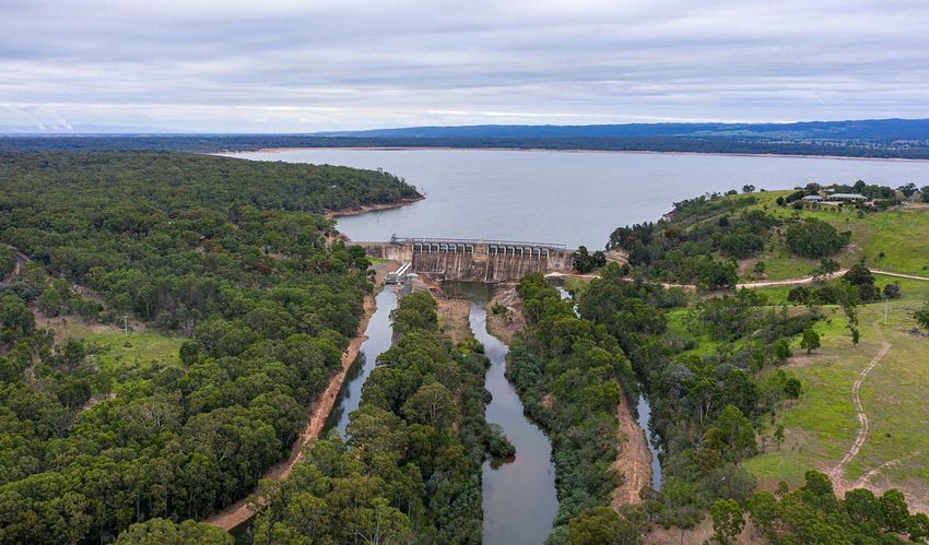
Table of Contents

 Acknowledgement                                      i

 Report summary                                       ii

 1 Introduction                                       1
    1.1    KEY OBJECTIVES                             1
    1.2    REGIONAL CATCHMENT STRATEGY GUIDELINES     1
    1.3    REPORT SCOPE                               3

 2 Background                                         4
    2.1    THE REGION                                 4
    2.2    VISION                                     5
    2.3    SOCIO-ECONOMIC PROFILE                     5
    2.4    CATCHMENT DRIVERS AND EMERGING ISSUES      6
    2.5    THEME BASED REVIEWS                       18

 3 Water                                             19
    3.1    INTRODUCTION                              19
    3.2    ASSESSMENT OF CURRENT CONDITION           20
    3.3    DESCRIPTION OF MAJOR THREATS AND TRENDS   23
    3.4    FUTURE DRIVERS AND EMERGING ISSUES        24

 4 Land                                              28
    4.1    INTRODUCTION                              28
    4.2    ASSESSMENT OF CURRENT CONDITION           29
    4.3    DESCRIPTION OF MAJOR THREATS AND TRENDS   30
    4.4    FUTURE DRIVERS AND EMERGING ISSUES        32

 5 Biodiversity                                      35
    5.1    INTRODUCTION                              35
    5.2    ASSESSMENT OF CURRENT CONDITION           36
    5.3    DESCRIPTION OF MAJOR THREATS AND TRENDS   37
    5.4    FUTURE DRIVERS AND EMERGING ISSUES        38

 6 Coasts and marine environment                     41
    6.1    INTRODUCTION                              41
    6.2    ASSESSMENT OF CURRENT CONDITION           42
    6.3    DESCRIPTION OF MAJOR THREATS AND TRENDS   44
    6.4    FUTURE DRIVERS AND EMERGING ISSUES        45

REVIEW AND PREPARATION FOR RENEWAL
7 Community                                         48
    7.1    INTRODUCTION                              48
    7.2    ASSESSMENT OF CURRENT CONDITION           49
    7.3    DESCRIPTION OF MAJOR THREATS AND TRENDS   51
    7.4    FUTURE DRIVERS AND EMERGING ISSUES        51

 References                                          54

 Appendix 1: Key themes and drivers                  56

REVIEW AND PREPARATION FOR RENEWAL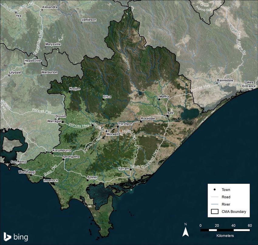
Acknowledgement
The authors of this report acknowledge the Traditional Owners of Country throughout Australia and recognise
their continuing connection to land, waters and community. We pay our respects to elders both past and
present.

We particularly acknowledge and pay our respects to the Traditional Land Owners and other indigenous people
within the West Gippsland catchment area: the Gunaikurnai, the Bunurong and Boon Wurrung, and the
Wurundjeri people. We also recognise the contribution of Aboriginal and Torres Strait Islander people and
organisations in land and natural resource management.

The authors of this report would also like to thank the RCS Steering Committee and the following organisations
and staff who contributed to this report through their participation in the four stakeholder workshops and/ or
review of the workshop discussion paper and draft report:
§   Agriculture Victoria, Neville Fernando
§   Bass Coast Shire, Phillip Pritchard
§   Baw Baw Shire, David Hair
§   Department of Environment Land Water and Planning (DELWP), Ryan Incoll
§   Environment Protection Authority, Stacey Clark
§   Gippsland Water, Debbie Archer
§   Gunaikurnai Land and Waters Aboriginal Corporation (GLaWAC), Daniel Miller and Lisa Hocking
§   Bunurong Land Council Aboriginal Corporation (BLCAC), Rohan Henry
§   Landcare - West Gippsland, Kathleen Brack and Sam Shannon
§   Latrobe City, Daniel Kelabora, Kevan Delaney and Les Hilton
§   Parks Victoria, Kerri Villier, Dan Brown
§   South Gippsland Shire, Vera Fordyce
§   South Gippsland Water, Kerry Matthews
§   Southern Rural Water, Ryan Wilson
§   Trust for Nature, John Hick
§   Wellington Shire, Andrew Wolstenholme
§   West Gippsland CMA, Adam Dunn, Belinda Brennan, Dan Garlick, Eleisha Keogh, Shelley McGuinness
    and Martin Fuller.

REVIEW AND PREPARATION FOR RENEWAL                                                                           i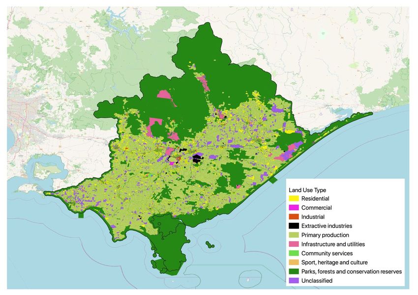
Report summary
This report has been prepared for the West Gippsland Catchment Management Authority (CMA) for stage 1
of the renewal and update of the West Gippsland Regional Catchment Strategy (RCS).
It provides a broad review of the existing RCS, particularly the condition of land, water, biodiversity, coasts and
marine, and community, as well as key current and emerging regional drivers and trends impacting the region,
based around:
§   Climate change
§   Population and demographic trends
§   Land use change
§   Industry outlook
§   Operating environment.

What we have found through this review is that West Gippsland is a complex region, with a diverse array of
high value environments and landscapes, from rare alpine peatland ecosystems to complex coastal wetland
and estuarine systems that are internationally recognised for their waterbird habitat values. These natural
landscapes hold special significance for the region’s Traditional Owners, the Gunaikurnai, the Bunurong and
Boon Wurrung, and the Wurundjeri people, and their aspirations will play an increasing role in how these
landscapes are managed into the future.

Whilst set amongst a backdrop of continued long-term ecological decline, not unique to the region, many areas
of the catchment are still in good condition. Despite a range of current and emerging threats, large areas are
demonstrating ecosystem resilience. This has been helped in part through the range of coordinated regional
NRM programs aimed at protection and restoration, supported through the last RCS. Notable examples
include:
§   the stabilisation in the extent of sea grass communities at Corner Inlet
§   the reduction in Spartina from coastal salt marsh communities
§   the extensive removal of willows from upstream catchments
§   the recovery and delivery of water for the environment
§   removal of major barriers to fish movement (such as the Thomson Fishway)
§   the protection of the Alpine peatlands ecological community, particularly on the Baw Baw plateau
§   protecting remnants of the critically endangered Red Gum Grassy Woodlands ecological community on
    the Gippsland Plain.

We have also found the region is currently going through major change from a range of influences. This change
is creating uncertainty for regional communities and presents significant challenges for future planning. The
major influences include:
§   population growth and changing demographics, particularly in coastal areas and from Melbourne’s
    continued urban growth
§   the continuing effects of climate change, particularly on sea level rise, water availability and the
    frequency and severity of major climatic events (droughts, fire and flood)
§   large scale industry transitions centred around mine closures in the Latrobe Valley and a move to
    renewable energy sources, land use change with smaller land holdings and growth in more intensive
    agriculture and a shift from harvesting native forests to plantations.

REVIEW AND PREPARATION FOR RENEWAL                                                                               ii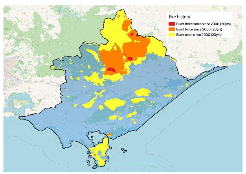
Population growth

The population in the West Gippsland catchment is expected to increase by 20% by 2036. Whilst this rate may
be smaller than other regional areas neighbouring Melbourne, such as Ballarat and Geelong, this growth will
continue to put pressure on the region’s natural assets. This is particularly the case in the western edge of the
region, which is influenced by Melbourne’s peri-urban fringe (with Warragul predicted to grow by 66% by 2036)
and in coastal areas (with Wonthaggi predicted to grow by 43% during the same period).

A growing population will also put more pressure on the use of the catchment’s waterways, coastlines, national
parks and other public open spaces. Increasing low-density greenfield development will also put additional
stress on the region’s riverine corridors and coastal environments. Protection and conservation of the region’s
natural landscapes is therefore paramount in order to prepare the catchment for this added pressure.

Climate change

The changing climate presents some significant challenges for the long-term management of the region.
Declining rainfall, higher temperatures and longer (and more frequent) droughts are predicted, as well as more
frequent and severe storm events and bushfires. There has been significant progress to secure water for the
environment over recent decades with the establishment of an environmental water reserve, and specific
environmental water entitlements for the region’s rivers. However, these actions have aimed to protect current
environmental values based on historic climate patterns. As the region experiences further effects of climate
change, the current arrangements may not be sufficient to sustain the long-term health of these waterways.

Expected sea level rise is also an emerging threat that could pose particular threats to the region’s low-lying
vegetation communities, including important areas of coastal saltmarsh. Rising sea levels and increased
coastal inundation and erosion will present major future planning challenges for coastal communities and for
the continued protection of the region’s two Ramsar sites, the Gippsland Lakes and Corner Inlet.

Land use change and industry transition

Private land used for farming makes up a large proportion of land use in the region. The scale, nature and
intensity of farming in the catchment is also changing. Some farmers are changing their practices and
expanding their operations to remain competitive in domestic and export markets, and to achieve sustainable
returns on investment. This includes increasingly intensive operations, such as growth in horticultural
production on land previously used for dairy farming. At the same time in some parts of the region there is an
increasing trend to smaller holdings, as farms are subdivided to create lifestyle properties.

Recent studies demonstrate many land managers in the catchment are aware of the value of protecting and
enhancing natural resources, and the benefits that some practices can provide both in lifting farm productivity
and contributing to broader catchment health, such as revegetation, and weed and pest animal control. Key
agencies, industry groups and community groups, (such as Landcare), are partnering to assist land managers
to adopt and implement improved land management in the region. This is being supported by better
coordination of effort and investment; ongoing research and improved sharing of knowledge and information,
including that held by landholders; and innovative incentive programs that engage new participants.

The other major changes include the closure of the Hazelwood mine and power plant, and the potential closure
of the Yallourn coal-fired power station in 2032 and Loy Yang in 2048. This transition is expected to have a
large impact on the local economy affecting local jobs and businesses in the Latrobe Valley. The other is the
Government’s transition from native forest timber harvesting to plantation, with the 2019 announcement that
logging in native forests would be phased out by 2030, and the immediate cessation of logging of old growth
forests.

REVIEW AND PREPARATION FOR RENEWAL                                                                             iii
A region in transition

Since the development of the last RCS, there have been of a number of major events and significant changes
to the operating environment (including legislative reform, new plans and strategies) that will have an impact
on the management of the catchment into the future. The following timeline captures these major changes.

                                   A REGION IN TRANSITION (2013-2020)

 West Gippsland RCS (2013-19)                                GLaWAC and West Gippsland CMA MoU signed
 launched                                                    Caring for Our Country (over 5 years)
                                                             Trust for Nature State-wide Conservation Plan
                                                     2013    Victorian Waterway Management Strategy

 West Gippsland Waterway Strategy (2014-22)                                                  Hazlewood mine fire
 Victorian Coastal Strategy
                                                     2014

 Gunaikurnai Whole-of Country Plan                           Lower Latrobe meander reinstatement
                                                             Threatened Species Strategy 2015

                                                     2015

 Significant                                                 Water for Victoria
 flooding in                                                 Our Catchments Our Communities
 Avon River
                                                             Environmental Contribution Tranche 4
                                                     2016    Victorian Auditor-General’s Report
                                                             (VAGO) - Ramsar Wetlands
                                                             West Gippsland NRM Climate Change
                                                             Strategy

 Return of 8 billion litres to the Thomson River             Victoria's Climate Change Adaptation Plan
 Hazelwood coal mine closes                          2017    Agriculture Victoria Strategy
                                                             Protecting Victoria’s Environment Biodiversity 2037

 Wellington and East Gippsland Shires in drought             Rural Drainage Strategy
 Lake Wellington Land and Water Management Plan              National Landcare Program - Regional Land Partnership
 West Gippsland Floodplain Management Strategy       2018    (over 5 years)
                                                             Climate Change Act
                                                             Marine and Coastal Act

 Black                                                       Thomson River Fishway installed
 Summer                                                      BLCAC and West Gippsland CMA MoU signed
 bushfires
                                                             Phase out of native forest harvesting by 2030
                                                     2019    Water Act Amendment Act
                                                             Australia's Strategy for Nature 2019-2030
                                                             Gippsland Integrated Water Management Strategic
                                                             Directions Statement

 Environmental Contribution Tranche 5 (four years)           COVID-19 Pandemic
 Long-term Water Resource Assessment for Southern
 Victoria (LTWRA)                                    2020
 Marine and Coastal Policy

REVIEW AND PREPARATION FOR RENEWAL                                                                                   iv
1           Introduction
This report has been prepared for the West Gippsland Catchment Management Authority (CMA) for stage 1
of the renewal and update of the West Gippsland Regional Catchment Strategy (RCS).
It provides a broad review of the existing RCS, particularly the major themes (land, water, biodiversity, coasts
and marine, and community). As part of the preparation of this report, current and future trends and
opportunities were tested with the West Gippsland CMA Board and key regional stakeholders through a series
of online workshops.
This report forms the first stage of a three-step process to develop West Gippsland’s fourth regional catchment
strategy (RCS 4) and has been timed to inform and provide the foundations for stage 2, the development of
RCS 4 – due for completion and Ministerial sign-off by July 2021 (refer Figure 1-1 below).

1.1         KEY OBJECTIVES

RMCG was engaged by West Gippsland CMA to deliver a project that examined the drivers and emerging
issues related to the major themes of the RCS. The objectives of the project were to:
§   Review and update information from the last 2013-19 RCS (RCS 3)
§   Integrate new strategies, plans and learnings into an updated regional focus
§   Identify current and future trends
§   Identify opportunities for future areas of NRM focus
§   Test current and future trends and opportunities with the Board and key regional stakeholders.

This report is the key product of the project.

                Stage 1                                                                 Stage 3
              Review and                              Stage 2                      Final draft, public
             preparation for                     RCS 4 development               consultation and final
                renewal                                                           Ministerial sign off

December 2019                                       July 2020                               July 2021

Figure 1-1: Review and RCS Renewal Stages

1.2         REGIONAL CATCHMENT STRATEGY GUIDELINES

The RCS is the primary integrated planning framework for land, water and biodiversity in each of the ten CMA
regions of Victoria. The Catchment and Land Protection Act 1994 (CaLP Act) in s.12(1)(a) stipulates that each
CMA must prepare an RCS for its region and to co-ordinate and monitor its implementation; as well as details
as to the contents of an RCS.
State-wide guidelines have been developed by the Victorian Catchment Management Council (VCMC) to
assist the CMAs in preparing the next suite of Regional Catchment Strategies (2021-2027), the fourth since
1997. The VCMC guidelines provide a minimum set of requirements, aligned with the requirements in the
CaLP Act. Each RCS is intended to be an overarching succinct and high-level strategy, with reference to more

REVIEW AND PREPARATION FOR RENEWAL                                                                            1
comprehensive, targeted and detailed supporting information found elsewhere, including regional sub-
strategies and action plans. Each successive RCS builds on the previous strategies, evolving over time.
A key focus of the latest guidelines is to provide greater consistency across Victoria for key areas of the next
round of strategies. The VCMC states that their guidelines ‘are intended to generate significant improvements
for Integrated Catchment Management (ICM) including:
§   Consistent presentation of all ten RCSs to form a coordinated set of ICM strategies covering the whole
    state
§   RCSs continuing to be regional-scale strategies developed collaboratively with Victoria’s communities,
    enabling effective local delivery of Government programs, all designed to improve catchment health
§   Improving the accessibility of the RCSs, enhancing communication, engagement and awareness in
    Victoria’s communities about catchment issues and opportunities
§   Supporting ease-of-use of RCSs for all stakeholders, particularly state-wide and multi-region
    organisations that bridge multiple CMA regions
§   Providing the ability to aggregate appropriate information from RCSs to enable a state-wide or multi-
    region view of a set of common overall outcomes and indicators Providing a consistent outcomes
    framework across all regions
§   An opportunity to promote and support Government policy and targets including consistency in
    demonstrating how the local-scale and regional-scale strategies and actions outlined in the ten RCSs
    contribute to state-wide outcomes and targets
§   Aligning with Traditional Owners and their ongoing connection to Country, acknowledging the importance
    of Indigenous Whole of Country Plans and Joint Management Plans
§   Providing the basis for the Natural Resources Management plans required under Australian Government
    programs such as the National Landcare Program
§   Recognising and aligning, where possible, with progress in the Environmental Accounts Framework
    under development nationally
§   Providing a clear rationale for securing funding resources from regional partners, Australian Government,
    private sector and philanthropic organisations for the ICM priorities of Victoria
§   Aligning the RCSs to the United Nations Sustainable Development Goals.’

KEY GUIDING PRINCIPLES

The RCS Guidelines finalised in December 2019 provide the following guiding principles for the development
of each strategy:
§   Integrated catchment management (ICM) approach
§   Regional ownership, embracing the regional delivery model, including co-delivery from committed
    partners
§   Place-based systems approach, at regional and local levels
§   Built on strong community engagement and stakeholder partnerships
§   Regard for Aboriginal cultural values and traditional ecological knowledge
§   Triple bottom line approach, including consideration of socio-cultural, economic, and environmental
    factors
§   Evidence-based, supported by science and defendable data
§   Flexibility to adopt new technologies and new information as they arise.

REVIEW AND PREPARATION FOR RENEWAL                                                                              2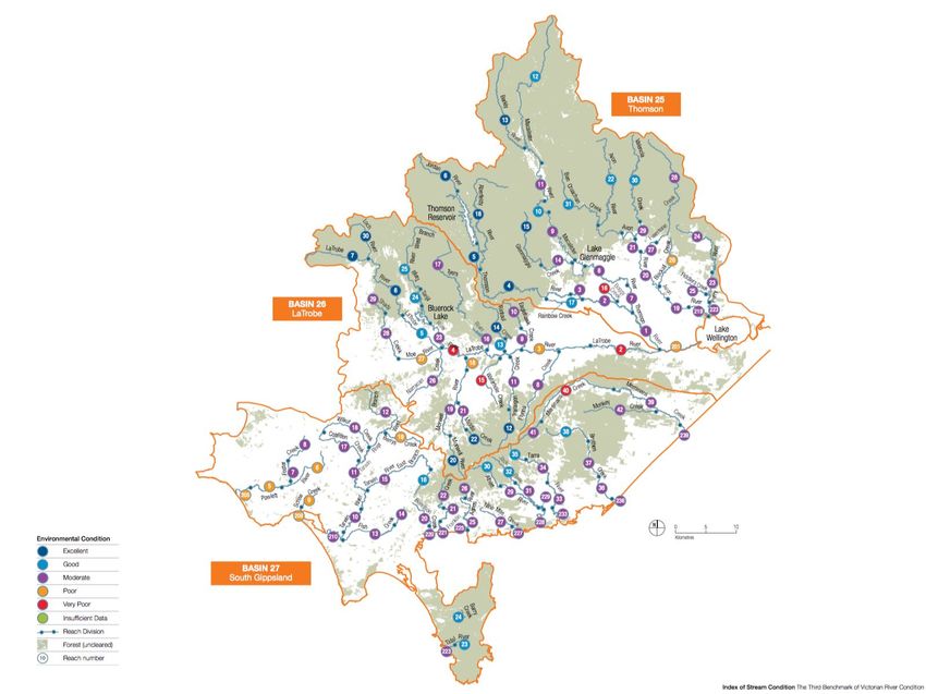
KEY THEMES

In line with the Our Catchments Our Communities Integrated Catchment Management Strategy (2016), the
five major themes in the RCS Guidelines are:
§   Water
§   Land
§   Biodiversity
§   Coasts and Marine
§   Community.
These themes largely align with the way governments and other investors plan and roll out their investment
programs. It is recognised, however, that in practice these themes are often inter-connected.

Figure 1-2: RCS Themes and ICM (Source: VCMC Regional Catchment Strategy Guidelines 2019)

As detailed above, the report presented here will provide the foundations for the development of West
Gippsland’s RCS 4. To do this, this report examines each of the five themes in detail (refer Sections 3 to 7).

1.3         REPORT SCOPE

This report focuses on Stage 1 of the RCS process, the review and preparation for renewal phase. It does not
involve the development of the RCS itself (refer Figure 1-2 above).
Accordingly, the focus of this report is a review of the current state of the catchment, the key regional drivers
that have emerged since the last RCS in 2013 and the key issues that are likely to emerge into the future. This
includes a raft of new state and regional policies, plans and strategies that have also been developed since
the last RCS. Among them are Water for Victoria, Biodiversity 2037 and the regional NRM Climate Change
Strategies. Some of the directions within these plans and policies are being integrated into the current RCS
implementation, whereas others will be incorporated into the renewed RCS.
A summary of the key drivers that have been considered is captured in detail in Section 2. They are also
considered for each of the themes in Sections 3 to 7.

REVIEW AND PREPARATION FOR RENEWAL                                                                             3
2           Background
2.1         THE REGION

The West Gippsland CMA region (Figure 2-1) extends across west, south and central Gippsland, from
Warragul and San Remo in the west to the Gippsland Lakes in the east, and from the Great Dividing Range in
the north to Wilsons Promontory in the south. The region extends into marine waters out to three nautical
miles, which marks the State of Victoria’s jurisdictional limit. It covers an area of 19,639 square kilometres
(including the marine environment) and accounts for almost eight percent of Victoria’s total land area.

Figure 2-1: West Gippsland CMA region

REVIEW AND PREPARATION FOR RENEWAL                                                                           4
Table 2-1: The region at a glance

    T H E R E GI ON A T A GL A N C E

    Total land area                                            17,685 km2.

    Population                                                 200,000 approx.

    Tenure                                                     46% Public land and 54% Private land.

    River Basins                                               Latrobe, Thomson and South Gippsland.

    Traditional custodians                                     Gunaikurnai, Bunurong and Boon Wurrung and Wurundjeri people

    Largest contributors to the regional                       Construction, mining, manufacturing, forestry, agriculture, fishing,
    economy                                                    food-related and utilities sectors1

    Largest employment sectors                                 Healthcare, social assistance and retail trade2

    Wetlands of international importance                       Gippsland Lakes and Corner Inlet Ramsar Sites.

    The region provides                                        ▪   23% of Australia’s milk production
                                                               ▪   most of Victoria’s electricity and gas (offshore)
                                                               ▪   about 60% of Melbourne’s water.

2.2              VISION

The current catchment vison in RCS 3 is ‘Catchment health - Gippsland’s wealth’.

2.3              SOCIO-ECONOMIC PROFILE

The following summary provides an overview of the socio-economic profile for the West Gippsland region. This
summary has been compiled from recent assessments34 and Australian Bureau of Statistics (ABS) data to
provide a snapshot of the prevailing socio-economic conditions occurring in the region.

Economic profile summary
The broader Gippsland Region has an estimated Gross Regional Product of $15.8 billion, underpinned by
energy generation, agriculture, forestry and tourism, as well as manufacturing5.
The regional economy of West Gippsland is highly concentrated around agriculture and state electricity supply,
the latter being situated in the Latrobe Valley around the cities of Moe, Morwell and Traralgon. Agriculture and
associated industries continue to be important exports for this region, and together with energy, mining and
construction account for approximately 41% of Gross Regional Product (GRP). Recent GRP figures for the
region include: agriculture (14%), energy (9%), mining (8%), construction (10%), manufacturing (10%) and
health care (8%). There is evidence of the growth of service-based industries, however, it is lower than in
Victoria as a whole.
The West Gippsland region has a lower Gross Regional Product (GRP) per capita than the Victorian average,
and GRP per capita has declined in the last ten years in comparison to Victoria as a whole, which has
witnessed sustained growth in economic output. The low relative output has been attributed in part to lower

1
    DTPLI (2014b).
2
    Ibid.
3
    Ibid.
4
    Aither (2019).
5
    RDV (2020) https://www.rdv.vic.gov.au/regional-partnerships/gippsland

REVIEW AND PREPARATION FOR RENEWAL                                                                                                    5
labour productivity, lower participation rates and an ageing population. Output in this region is also impacted by workers living in the region and commuting to Melbourne, resulting in their economic output being attributed to other regions. Capital investment in the Gippsland region is below the Victorian average, with the exception of the Bass Coast Local Government Area (LGA), which is forecast to experience strong population growth under the influence of Melbourne’s peri-urban growth. Non-residential construction is highest in the Wellington LGA. The lowest rates of capital investment are seen in Latrobe and South Gippsland LGAs, which also have lower rates of population growth. A major long-term industry transition is also underway in the Latrobe Valley with the closure of the Hazelwood mine and power plant, and the potential closure of the Yallourn coal-fired power station in 2032 and Loy Yang in 2048. This transition is expected to have a large impact on the local economy affecting local jobs and businesses. In recognition of this impact, the Victorian government created the Latrobe Valley Authority to partner with the community and businesses to deliver strategic actions that improve outcomes for the regional economy. A major focus of this transition will be the delivery of the Latrobe Valley Regional Rehabilitation Strategy to guide rehabilitation of the Latrobe Valley coal mine voids and surrounding areas. Social profile summary There is severe disadvantage in Latrobe LGA, while other LGAs in the region range from moderate to average levels of relative disadvantage. Levels of disadvantage (outside of Latrobe LGA) are generally consistent to comparable LGAs in other regions (e.g. rural LGAs, or LGAs in peri-urban Melbourne). The West Gippsland CMA region is expected to experience population growth of approximately 20% by 2036, particularly the western part of the region with its proximity to the peri urban fringe of Melbourne. However, the population is also expected to continue to age and decline in most rural areas of the catchment. This is being accompanied by a continuing shift of services into the larger regional centres. Population health is slightly worse in the region than the state average. Life expectancy is generally lower (particularly for males) than for Victoria as a whole, and there are generally higher rates of obesity. However, access to health services, General Practitioners, and utilisation of hospital services are all relatively similar or better than the Victorian average. When considering wellbeing across the region, results are similar to, or slightly above, the Victorian average. This is aligned with typically higher rates of wellbeing reported by regional populations. The exception is Latrobe LGA, which has reported wellbeing below the state average. 2.4 CATCHMENT DRIVERS AND EMERGING ISSUES The following are a list of the identified key drivers and emerging issues relevant to the long-term health of the catchment. § Climate change § Population and demographic trends § Land use change § Industry outlook § Operating environment. Whilst not covered in detail here, the impact of the current Coronavirus (COVID-19) pandemic is likely to have short to medium term effects on visitation, tourism and local businesses in the region, as well as long-term changes to how communities work, commute and communicate. The full extent of these emerging longer-term changes will only become evident over time but should be considered as part of the planning for the next RCS. REVIEW AND PREPARATION FOR RENEWAL 6
CLIMATE CHANGE

As outlined in the West Gippsland Regional NRM Climate Change Strategy6, climate change is expected to
present an ongoing challenge to the health and management of the region’s natural assets.
The latest climate projections from the Bureau of Meteorology and CSIRO show that in the future, West
Gippsland will be subject to a warmer, drier and more variable climate. A brief summary of the specific climate
change projections for West Gippsland is provided in Table 2-1 below.
Table 2-1: Climate Projections for the West Gippsland Region7

    C L I MA T E P R OJ E C T I ON S F OR T H E WE S T GI P P S L A N D R E GI ON

    Temperature         Average temperatures are predicted to increase across all seasons.
                        More very hot days and longer duration of warm spells.

    Rainfall            Less rainfall, particularly in winter and spring.
                        More frequent and intense heavy rainfall events.

    Drought             Increased frequency and duration of extreme droughts.

    Snow                Continued decline in snowfall and maximum snow depth.

    Wind                Higher wind speeds during the cooler months (July to October).
                        Fewer but more intense east coast lows.

    Fire                Harsher fire weather and longer fire seasons.

    Sea level           Higher sea levels and more frequent sea level extreme events (including storm surge).

    Ocean               Warmer and more acidic oceans.

The Millennium Drought (1997-2009) saw a shift in the seasonality of rainfall, with big decreases in autumn
rainfall occurring and catchments drier at the beginning of winter, leading to less run-off from winter and spring
rainfall. Long-term reductions in rainfall and increased temperatures are also expected to result in drier
catchments, impacting both surface and ground water availability. Climate change is also expected to cause:
§    Increased frequency of higher intensity rainfall events resulting in greater flooding, waterway bed and
     bank erosion and introduction of sediments, pollutants and nutrients into waterways
§    Lower base flows in rivers and higher temperatures which, when combined with elevated nutrient levels,
     impact the occurrence of algal blooms in rivers and creeks
§    Reduced connectedness of waterways (due to low flows) reducing opportunities for movement and
     dispersal of plants and animals.
The expected increase in the frequency and extent of coastal inundation, erosion and flooding as a result of
sea level rise, storm surge, tides and rainfall will impact the health of estuaries and coastal habitats, as well as
agriculture through inundation and salinisation.
The Victorian Government’s recent Long-term Water Resource Assessment (LTWRA)8 has found long-term
surface water availability across southern Victoria has declined by up to 21 per cent compared to when it was
last estimated for the sustainable water strategies in the mid 2000’s. The main cause of declines in surface

6
    WGCMA (2016b).
7
    Ibid.
8
    DELWP (2020).

REVIEW AND PREPARATION FOR RENEWAL                                                                                7
water availability are drier conditions. In some basins, upstream interception of water for storage in domestic
and stock dams, and for forestry plantations, may also be contributing to the decline in surface water
availability. The decline in water availability has impacted the environment, farming, industry and other water
users. The LTWRA also determined, for each river basin, whether declines in long-term surface water or
groundwater availability have fallen disproportionately onto either consumptive uses or the environment
(Figure 2-2). For example, in the Latrobe Basin the decline in long-term surface water availability has not been
shared equally: the environment now has a smaller share of the available water.
Figure 2-2: Basins where the declines in surface water availability have fallen disproportionately and,
therefore, action might be warranted to redress the imbalance9.
In addition to the impact on water resources and waterway health, other key impacts of climate change include:
§ Warmer and drier climate – impacting on soil carbon levels, soil erosion risk, loss of nutrients,
changes in land suitability for agriculture and increases in the occurrence of ‘transient’ salinity. This will
also result in a gradual change in the composition of vegetation communities as some species are
replaced by those suited to a warmer, drier environment
§ Intense rainfall, flooding and erosion – impacting infrastructure, crops, livestock and soil with higher
rates of soil erosion and downstream impacts of sediment deposition (e.g. Gippsland Lakes and Corner
Inlet)
§ Increase in both the frequency and intensity of bushfire – impacting on the distribution and
composition of ecosystems, yield and quality of water from fire-affected catchments, security of
plantation forests, emissions of greenhouse gases to the atmosphere and damage to property, livestock
and crops.
9
DELWP (2020)
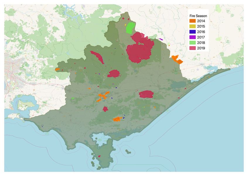
REVIEW AND PREPARATION FOR RENEWAL 8The fire map below (Figure 2-3) shows the areas that were burned by large fires in 2007, 2009, 2013 and
2019. This continues a trend of a marked reduction in the intervals between large-scale bushfires in the
catchment since the early 2000s. Recent research10 confirms that intervals between successive fires are
important as trees need sufficient time to recover their regenerative capacity. This is particularly the case for
eucalypts like alpine ash (Eucalyptus delegatensis) that only begin to produce seeds around 20 years after
fire. This means that fire intervals need to be greater than 20 years before alpine ash will have sufficient seeds
for successful regeneration (after the next fire).
Figure 2-3: Large parts of the catchment have been repeatedly burned in recent decades11.
POPULATION AND DEMOGRAPHIC TRENDS
The majority of regional centres and towns in West Gippsland have experienced population growth over the
last 35 years. Growth has been particularly strong on the fringe of Melbourne and in coastal areas, with the
coastal town of Inverloch increasing in population by over 200 per cent. Warragul, Korumburra and Wonthaggi
have been identified as key peri-urban growth locations and each have experienced growth of 50-90 percent
since 1981. Some towns in the region have experienced population decreases. These towns include Moe-
Newborough, Morwell, Churchill, Yarram and Yallourn North.
The estimated population for the West Gippsland region for 2016 was 189,535 people. By 2036 this is expected
to grow by 20% to 225,000 people12.
10
https://pursuit.unimelb.edu.au/articles/why-australia-s-severe-bushfires-may-be-bad-news-for-tree-regeneration (2020)
11
Fire boundary data from https://www.data.vic.gov.au (accessed 24/5/2020)
12
Victoria in Future (2019).
REVIEW AND PREPARATION FOR RENEWAL 9230,000
220,000
210,000
200,000
190,000
180,000
170,000
160,000
2016 2021 2026 2031 2036
Figure 2-4: Projected population growth for West Gippsland13
Table 2-2 shows the population projections by subsets of West Gippsland LGAs, with Drouin, Warragul and
Wonthaggi expected to experience the highest population increases over the next 20 years.
Table 2-2: Population projections by Local Government Area for West Gippsland14
L ocal VICTORIA IN FUTURE YEAR %
Government SMALL AREAS INCREASE
Areas (V I F S A )15 2016 2021 2026 2031 2036 2016-36
Baw Baw Neerim-Trafalgar 13,700 14,370 15,080 15,920 16,670 21.68%
Bass Coast Wonthaggi 22,780 25,450 27,910 30,450 32,660 43.37%
Drouin-Warragul (30%) 10,688 12,471 14,216 16,036 17,763 66.20%
Latrobe Churchill 11,570 11,680 11,870 12,070 12,250 5.88%
Glengarry North-Tyers 4,830 4,870 4,940 5,010 5,080 5.18%
Moe 16,830 16,880 17,100 17,370 17,650 4.87%
Morwell 14,030 14,100 14,230 14,380 14,560 3.78%
Traralgon 27,360 28,910 30,440 32,070 33,650 22.99%
South Gippsland Leongatha 11,230 11,660 12,210 12,780 13,310 18.52%
Promontory 8,940 9,170 9,370 9,560 9,730 8.84%
Korumburra (30%) 2,688 2,832 2,976 3,120 3,270 21.65%
Wellington Heyfield-Maffra 14,110 14,610 15,100 15,660 16,150 14.46%
Rosedale 9,150 9,440 9,720 10,030 10,320 12.79%
Sale 14,890 15,330 15,830 16,400 16,910 13.57%
Yarram 5,370 5,460 5,530 5,600 5,570 3.72%
TOTAL 188,166 197,233 206,522 216,456 225,543 19.86%
Migration is the key driver of demographic and population change in the West Gippsland region. There has
been high net in-migration to the western edge of the region which is influenced by Melbourne’s peri-urban
fringe and net out-migration in and around the Latrobe LGA. Other significant demographic trends that are
occurring are:
13
Victoria in Future (2019)
14
Ibid.
15
VIFSAs are based on ABS Statistical Areas Level 2.
REVIEW AND PREPARATION FOR RENEWAL 10§ Whilst not as pronounced as Victoria as a whole, the West Gippsland population is projected to age over
the next 30 years. This has significant implications for housing preferences with 84% of future household
growth (for the whole of Gippsland) being from households with one person or couples without children
§ The SEIFA IRSAD16 indicator of relative advantage and relative disadvantage shows that LGAs within
the West Gippsland region demonstrate highly varied rates of disadvantage:
- The Latrobe LGA is the seventh most disadvantaged LGA in Victoria. Disadvantage is concentrated
in Moe, Morwell and to a lesser extent Traralgon
- Across rural farming areas of South Gippsland and Wellington LGAs, there is a pattern of higher
relative advantage in farmlands, and higher relative disadvantage concentrated in rural towns. This
difference may be due to the gradual economic decoupling of small rural towns and the surrounding
farm businesses.
Key impacts from population and demographic trends include:
§ Increasing domestic and stock water use – growing populations, rural subdivisions and fluctuating
water availability are increasing the demand for domestic and stock water
§ Development on land with high agriculture and/or conservation value – further pressure on land
with high agricultural and/or conservation values as a result of urban development and subdivision for
rural lifestyle blocks on agricultural land
§ Increases in pollution and waste – growing populations will contribute to increased levels of pollution
and waste
§ Nature-based tourism – larger populations will result in increased visitation and associated impacts on
nature-based tourism sites in the region including coastal areas, rivers and creeks, national parks and
reserves.
16
ABS (2020) Socio-Economic Indexes for Areas (SEIFA), Index of Relative Socio-economic Advantage and Disadvantage (IRSAD).
REVIEW AND PREPARATION FOR RENEWAL 11LAND-USE CHANGE
Land use across the Gippsland region is highly variable (refer Figure 2-5 below). Some parts of the region are
highly modified from their pre-European settlement state and support agricultural, industrial and residential
uses. Other areas are less disturbed, with large amounts of native forest, used for both conservation and timber
harvesting. A large proportion of land in the Gippsland region is publicly owned, and this makes up a
considerable proportion of Victoria’s total public land.
Figure 2-5: Land use in West Gippsland CMA region (Australian property classification codes)17
Some areas of the region remain under development pressure. This often leads to farmland being converted
to residential and rural residential uses, and also small lifestyle properties. This pattern is particularly apparent
in coastal areas and on the western edge of the region. The change in total area of land used for agriculture
in the region is consistent with this pattern (Figure 2-6). Between 2011 and 2016 the area of land used for
agriculture decreased by around 20 per cent, around 130,000 hectares, which continues a decades long
pattern. A significant portion of this change is likely to be commercial farms being converted to smaller lifestyle
properties.
Over that same time, the number of livestock farms also decreased but not at the same rate. In fact, the number
of farms with meat cattle only decreased by four per cent over that same time (Figure 2-7). This could reflect
two simultaneous drivers – economic efficiency driving properties to increase in size to remain commercially
viable, along with fragmentation of commercial farms into smaller properties that do not meet the threshold to
be considered farms under the ABS agricultural census.
17
Victorian Land Use Information System (2014/15).
REVIEW AND PREPARATION FOR RENEWAL 12Other land use changes that are observable in the region include:
§ Plantation forestry on lower productivity agricultural land (e.g. in Perry River catchment)
§ Increased intensification of agriculture systems – including growth in horticultural production, particularly
in the MID irrigation area
§ Urban expansion and continued fragmentation of commercial farms into smaller lifestyle properties.
Figure 2-6: Change in area of holdings in West Gippsland CMA region18
4,000
3,500
3,000
2,500
2,000
1,500
1,000
500
-
2010-11 2015-16 2017-18
Number of agricultural businesses Number of ag businesses with cattle
Number of dairy farms Number of ag businesses with meat cattle
Figure 2-7: Changes in the number of agricultural businesses, 2011 to 2018, West Gippsland CMA
region19
18
ABS agricultural census data
19
Ibid.
REVIEW AND PREPARATION FOR RENEWAL 13INDUSTRY OUTLOOK
The region supports a number of major industries and related strategic assets20 including major water supply
dams and the Wonthaggi desalination plant, wind farms and significant brown coal deposits and major power
stations in the Latrobe Valley. It also supports a major forestry sector, and large areas of productive agriculture
including dairy, beef and horticulture centred around the Macalister Irrigation District.
Agriculture
Figure 2-8 shows the value of different agricultural production in the Gippsland region (i.e. data includes East
and West Gippsland). Livestock industries are clearly dominant, with dairy and beef industries making up the
vast majority of production.
Figure 2-8: Value of agricultural commodities produced, 2017-18 Gippsland-Latrobe region21
Dairy Industry
As the major agricultural industry in the region, the future direction of the dairy industry will have a major
influence on land use and management in West Gippsland. Some of the observable trends are:
§ Gippsland milk volume increases year-on-year, indicating that farm size and efficiency continues to
increase (while farm numbers continue to decline)
§ The long-term trends continue to see the industry move to fewer larger farms (Figure 2-9 below)
§ Milk production continues to contract in northern Victoria and east Gippsland
§ Industry changes in northern Victoria are being driven by water prices (and climate variability) and there
appears to be some move to rainfed areas (Gippsland and south west Victoria)
§ Within Gippsland there is some shift from dairy to horticulture within the Macalister Irrigation District
§ Competition for land is a constraint for the industry in some parts of West Gippsland. High land prices
make increasing the size of operations challenging.
20
RDV (2015)
21
https://www.agriculture.gov.au/abares
REVIEW AND PREPARATION FOR RENEWAL 14Figure 2-9: Distribution of farms by estimated value of agricultural operations, Latrobe-Gippsland
region, 2017–1822
Forestry
The region has a significant forestry industry with native forest and softwood plantations supporting an
important timber, pulp and paper manufacturing sector. However, with the Government’s 2019 announcement
that logging in native forests would be phased out by 2030, and the immediate cessation of logging of old
growth forests, Gippsland’s timber industry is in the midst of a major transition from native forest timber
harvesting to plantation. In 2016 there were about 2.7 million hectares of native forests in the Latrobe -
Gippsland region. The majority of these native forests were multiple use public land, available for timber
production (1,468,400 hectares), while 933,900 hectares were in conservation reserves and 232,300 hectares
were privately managed.
Nearly one quarter of Victoria’s plantation estate is located in the broader Gippsland area23. In 2014–15, the
most recent year for which regional data are available, the total plantation area in the Latrobe - Gippsland
region was about 97,600 hectares, about one third of which is hardwood (Tasmanian blue gum (Eucalyptus
globulus) and shining gum (Eucalyptus nitens)). The main softwood plantation species in Victoria is radiata
pine (Pinus radiata). The differences in area of plantations and native forest are an indication of the magnitude
of the transition required for this industry.
Energy
The region also continues to be a major energy producer, through both coal and natural gas. However, the
presence of the electricity transmission infrastructure in the region appears to be an important driver for
development of renewable energy – solar, wind and geothermal.
Other industries and trends
§ Mineral sands mining is being explored for the Glenaladale area immediately to the east of the region
§ Interest in onshore gas exploration remains, though subject to policy restrictions
§ Extractive industries are growing with demand from construction, particularly infrastructure projects in
Melbourne and surrounds.
22
https://www.agriculture.gov.au/abares
23
DTPLI (2014a)
REVIEW AND PREPARATION FOR RENEWAL 15OPERATING ENVIRONMENT
Since the development of the last RCS, there have been significant changes to the regional operating
environment (including legislative reform, new plans and strategies and shifts in funding) that will have an
impact on the management of the catchment into the future. A summary is provided here with further detail
outlined for each of the themes in Sections 3 to 7.
Legislative reform
There have been numerous legislative reviews in recent years, and while most are unlikely to have a significant
impact on the current RCS, some of these inquiries may have implications for the renewed RCS. These
include:
§ EPA inquiry and Environment Protection Amendment Act 2018
§ Marine and coastal reforms (including Marine and Coastal Act 2018 and Marine and Coastal Policy)
§ Flora and Fauna Guarantee Amendment Act 2019
§ Water Act Amendment Act 2019.
These are summarised briefly below:
§ Environment Protection Amendment Act 2018
- introduces a General Environmental Duty, which requires anyone conducting an activity that poses
risks of harm to human health and the environment to understand and minimise those risks, so far as
is reasonably practicable.
§ Flora and Fauna Guarantee Amendment Act 2019
- provides a modern and strengthened framework for the protection of Victoria’s biodiversity
- introduces principles to guide the implementation of the Flora and Fauna Guarantee Act, including
consideration of the rights and interests of Traditional Owners and the impacts of climate change
- requires consideration of biodiversity across government to ensure decisions and policies are made
with proper consideration of the potential impacts on biodiversity
- clarifies existing powers to determine critical habitat and improves their protection by encouraging
cooperative management
- modernises the Flora and Fauna Guarantee Act’s enforcement framework including stronger
penalties.
§ New Marine and Coastal Act and Policy:
- provides a greater focus on the marine environment
- ensures greater recognition and respect for the aspirations of Traditional Owners
- embeds climate change in all aspects of future planning
- provides guidance on new roles and responsibilities.
§ Water and Catchment Legislation Amendment Act 2019:
- ensures greater recognition and involvement of Traditional Owners and Aboriginal Victorians in the
management and planning of waterways and catchments
- provides greater consideration of the recreational values of water and waterways for communities
REVIEW AND PREPARATION FOR RENEWAL 16- provides clearer planning for future challenges, such as climate change, population growth and
changing demands for water, with a greater focus on compliance and assurance along with
transparency and justification.
New plans and strategies
A range of key state and regional plans and strategies have also been developed since the last RCS. They
include:
- Agriculture Victoria Strategy (2017).
- Water for Victoria – Water Plan (2016)
- Victorian Waterway Management Strategy (2013)
- Protecting Victoria's Environment - Biodiversity 2037 (2017)
- Our Catchments Our Communities (2016-19)
- Victoria's Climate Change Adaptation Plan (2017-2020)
- West Gippsland Waterway Strategy (2014-2022)
- West Gippsland Regional NRM Climate Change Strategy (2016)
- West Gippsland Floodplain Strategy (2018-2027).
A number of the actions within these strategies have been integrated into the current RCS implementation
program, and they will also be relevant to the renewed RCS.
Likewise, the development of RCS4 will require alignment and policy integration with a number of new
strategies and plans to be developed over the next two years (e.g. new Central and Gippsland Sustainable
Water Strategy and new Marine and Coastal Strategy).
Funding environment
Since the last RCS, the traditional funding environment has changed with longer but more certain funding
cycles, and a shift to a more targeted approach to delivering and demonstrating investment outcomes. Further
details are provided below for the main Australian and Victorian Government funding programs.
Under these arrangements, the next RCS will be critical for future funding rounds by ensuring the currency of
regional NRM priorities.
§ Australian Government (Regional Land Partnerships (RLP) Program under the National Landcare
Program (NLP) phase II)
- A focus on national priorities – EPBC listed species and communities, national and international
obligations (e.g. Ramsar, World Heritage)
- Purchasing model – multi-year (up to five years) competitive funding, with high levels of accountability,
and reporting on specific outcomes
- Shift away from regional autonomy to centralised approaches
§ Victorian Government
- Renewed focus on demonstrating and communicating long-term outcomes and impact (in line with
Water for Victoria)
- Change from an annual to four yearly funding cycle for Victorian Government investment
(Environmental Contribution (EC) levy) in line with NLP - providing greater funding certainty.
REVIEW AND PREPARATION FOR RENEWAL 172.5 THEME BASED REVIEWS
As detailed above, a review report has been developed for each of the following themes:
§ Water: waterways (including rivers, estuaries and wetlands), surface water and groundwater
§ Land: land-use, groundcover and agricultural productivity
§ Biodiversity: habitat, native vegetation and native animals
§ Coasts and marine environment
§ Community: Traditional Owners and Aboriginal Victorians, and communities involved in integrated
catchment management.
These themes are the focus of the following five sections (2 to 7) of this report, which have been structured as
follows:
§ Introduction
§ Assessment of current condition
§ Description of major threats and trends
§ Future drivers and emerging issues.
REVIEW AND PREPARATION FOR RENEWAL 183 Water 3.1 INTRODUCTION There are three key sub-themes under the water theme: § Waterways (rivers and streams; estuaries and wetlands) § Surface water resources § Groundwater. WATERWAYS Rivers and streams The region’s major waterways include the Thomson, Latrobe, Macalister, Avon, Perry, Powlett, Tarwin and Tarra Rivers. All of these waterways flow to the Victorian coast, discharging through the Gippsland Lakes, Corner Inlet or directly into Bass Strait and the Southern Ocean. The region’s rivers support a range of environmental, social, recreational and cultural values and provide water for towns, industry and food production. Estuaries The region’s estuaries, which are also an important component of the Coasts and Marine Theme (refer Section 6) are an important link between the ocean and land, where fresh water from rivers and streams mixes with salty marine waters. Estuaries are dependent on both of these water sources to provide a diverse and healthy environment. The estuaries in the West Gippsland catchment area range from near natural to highly modified, and include: § Bourne Creek, Powlett River, Wreck Creek § Ayr Creek, Screw Creek, Anderson Inlet § Darby River, Tidal River and estuaries of Corner Inlet and the east side of Wilsons Promontory § Merriman Creek § Estuarine reaches of rivers that enter into Lake Wellington. REVIEW AND PREPARATION FOR RENEWAL 19
Wetlands
The region’s wetlands include individual wetlands, wetland complexes, and their associated floodplain
ecosystems.

Corner Inlet and the Gippsland Lakes are wetlands of international importance under the Ramsar convention
and are critical habitats for many vulnerable and threatened species, including migratory birds species listed
under the Japan-Australia Migratory Bird Agreement (JAMBA), China Australia Migratory Bird Agreement
(CAMBA) and Republic of Korea-Australia Migratory Bird Agreement (ROKAMBA).

GROUNDWATER AND AQUIFERS

The West Gippsland region is a rich source of groundwater, suitable for livestock, domestic, garden and
industrial use. In some areas, particularly along the Ninety Mile Beach coast and Gippsland Plains the high
yielding aquifers are important sources of water for irrigation and town water supply, including major city
centres like Sale in the east24. Groundwater also contributes to the environmental values of some ecosystems.
These are known as groundwater dependent ecosystems (GDEs) and can include waterways, wetlands,
estuaries and vegetation.

SURFACE WATER RESOURCES

The West Gippsland region has valuable surface water resources for environmental, agricultural, industrial,
urban and potable water supply purposes. The region has 24 of Victoria’s 134 declared water supply
catchments, which supply water for both stock and domestic purposes and are protected under the CaLP Act.
The region incorporates three major river basins: the Thomson, Latrobe and South Gippsland Basins. The
Thomson Basin (incorporating the Avon, Thomson and Macalister Rivers) and the Latrobe Basin both drain
the southern fall of the Great Dividing Range and the northern slopes of the Strzelecki Ranges into Lake
Wellington. The South Gippsland Basin’s ten rivers and streams drain the southern slopes of the Strzelecki
Ranges to the coast between San Remo in the west and Loch Sport in the east.

3.2            ASSESSMENT OF CURRENT CONDITION

WATERWAYS

Rivers and streams

Figure 3-1: Index of Stream Condition 2010 Summary for the West Gippsland Region

24
     WGCMA (2013).

REVIEW AND PREPARATION FOR RENEWAL                                                                          20
Figure 3-2: Index of Stream Condition 2010 results by reach for the West Gippsland region25.
According to the last Index of Stream Condition benchmark conducted in 2010, 34% of stream reaches
assessed were in ‘excellent’ or ‘good’ condition, mostly located in the Thomson and Latrobe Basins. The
majority of stream reaches assessed in the region were in ‘moderate’ condition.
Basin streamflow was above the long-term average from 2010-11 to 2011-12, and close to or slightly below
the long-term average from 2012-13 to 2014-15.
25
DEPI (2013).
REVIEW AND PREPARATION FOR RENEWAL 21Wetlands
The Index of Wetland Condition (IWC) was developed to assess the condition of Victoria’s wetlands. Seventy-
two wetlands in the West Gippsland region were assessed between 2009 and 2013 using the IWC, 26 of these
were part of a state-wide assessment of wetland condition and the remainder were completed to inform the
selection and or monitoring for onground works26. Of the sites assessed, the majority were in moderate to good
condition (18 and 29 respectively), 12 were in excellent condition and 15 were in poor to very poor condition.
Estuaries
As also detailed in Section 6, DELWP has developed a condition assessment method for estuaries called the
Index of Estuary Condition (IEC). The IEC is being applied to estuaries throughout Victoria to document their
current condition and establish a baseline for future monitoring.27
GROUNDWATER
Groundwater in Gippsland is contained in layers of sedimentary sand, gravel, clay, limestone and coal, and in
fractured rock. Groundwater levels are generally stable but some areas are declining. Management of
groundwater needs to take into account the amount of water that enters and is lost from the aquifer each year
and how much water is stored in the aquifer. The process of water entering the ground to become groundwater
is called recharge. The volume of recharge and how fast it enters groundwater depends on climate, aquifer
depth, the types of plants that use water from the soil and the types of soil and rock through which the water
must pass28.
SURFACE WATER RESOURCES
About 92 per cent of the water extracted for towns, industry and agriculture in Gippsland is sourced from
waterways, with about 8 per cent sourced from groundwater and a very small proportion drawn from alternative
sources such as stormwater and recycled wastewater.29
Table 3-1 shows results of the Victorian Government’s recent Long-term Water Resource Assessment
(LTWRA)30 for river basins in West Gippsland. It found that long-term surface water availability has declined
in the region (5-12%) compared to when it was last estimated for the sustainable water strategies in the mid
2000’s. The main cause of these declines are drier conditions. In some basins, upstream interception of water
for storage in domestic and stock dams, and for forestry plantations, may also be contributing to the decline in
surface water availability. This decline has impacted the environment, farming, industry and other water users.
The LTWRA also determined, for each river basin in the region, whether declines in long-term surface water
or groundwater availability have fallen disproportionately onto either consumptive uses or the environment.
For example, in the Latrobe Basin the decline in long-term surface water availability has not been shared
equally: the environment now has a 3% smaller share of the available water.
26
WGCMA (2014b).
27
https://www.water.vic.gov.au/waterways-and-catchments/rivers-estuaries-and-waterways/estuaries?_ga=2.108352135.401812174.1589329315-
55781662.1589329315.
28
Ibid.
29
DSE (2011).
30
DELWP (2020).
REVIEW AND PREPARATION FOR RENEWAL 22You can also read