Nature-Based Engineering: A Review on Reducing Coastal Flood Risk With Mangroves
←
→
Page content transcription
If your browser does not render page correctly, please read the page content below
REVIEW
                                                                                                                                                 published: 08 July 2021
                                                                                                                                        doi: 10.3389/fmars.2021.702412

                                             Nature-Based Engineering: A Review
                                             on Reducing Coastal Flood Risk With
                                             Mangroves
                                             Rik Gijsman 1*, Erik M. Horstman 1 , Daphne van der Wal 2,3 , Daniel A. Friess 4,5 ,
                                             Andrew Swales 6 and Kathelijne M. Wijnberg 1
                                             1
                                              Marine and Fluvial Systems, Faculty of Engineering Technology, University of Twente, Enschede, Netherlands, 2 Faculty of
                                             Geo-Information Science and Earth Observation, University of Twente, Enschede, Netherlands, 3 Department of Estuarine
                                             and Delta Systems, NIOZ Royal Netherlands Institute for Sea Research, Yerseke, Netherlands, 4 Department of Geography,
                                             National University of Singapore, Singapore, Singapore, 5 Centre for Nature-Based Climate Solutions, National University of
                                             Singapore, Singapore, Singapore, 6 National Institute of Water and Atmospheric Research, Hamilton, New Zealand

                                             Integration of mangroves in projects to reduce coastal flood risk is increasingly
                                             being recognised as a sustainable and cost-effective alternative. In addition to the
                                             construction of conventional hard flood protection infrastructure, mangroves not only
                             Edited by:
                     Stijn Temmerman,
                                             contribute to attenuating flood events (functionality), they also recover in, and adapt
       University of Antwerp, Belgium        to, a changing climate (persistence). The implementation of mangroves in flood risk
                       Reviewed by:          reduction, however, remains complex. This is because the innate functionality and
                          Lida Teneva,       persistence of mangroves depend on a range of environmental conditions. Importantly,
            Independent Researcher,
           Sacramento, United States         mangroves may collapse when environmental impacts or climatic changes exceed key
                   Barbara Zanuttigh,        system thresholds, bringing uncertainty into a situation where failure could endanger
           University of Bologna, Italy
                                             lives and livelihoods. The uncertainties in mangrove functionality and persistence can
                   *Correspondence:
                          Rik Gijsman
                                             be dealt with by (1) improving insights in how ecological and physical processes
                 r.gijsman@utwente.nl        affect mangrove functionality and persistence across scales, (2) advancing tools to
                                             accurately assess and predict mangrove functionality and persistence, and (3) adopting
                   Specialty section:
                                             an adaptive management approach combined with appropriate engineering interventions
         This article was submitted to
                      Ocean Solutions,       to enhance mangrove functionality and persistence. Here, we review existing evidence,
               a section of the journal      monitoring techniques and modelling approaches from the viewpoint of mangrove
          Frontiers in Marine Science
                                             functionality and persistence. Inspired by existing guidelines for Nature-based Solutions
             Received: 29 April 2021
            Accepted: 08 June 2021
                                             (NbS) to reduce flood risk, we provide an operationalization for this new approach.
            Published: 08 July 2021          In addition, we identify where further research efforts are required for the practical
                              Citation:      application of mangroves in coastal flood risk management. Key aspects in the
   Gijsman R, Horstman EM, van der
                                             variability and uncertainty of the functionality and persistence of mangroves are their
      Wal D, Friess DA, Swales A and
   Wijnberg KM (2021) Nature-Based           failure and recovery mechanisms, which are greatly site- and storm-specific. We
  Engineering: A Review on Reducing          propose five characteristic damage regimes that result in increasing reductions of
  Coastal Flood Risk With Mangroves.
            Front. Mar. Sci. 8:702412.
                                             mangrove functionality as well as post-storm recovery periods. Further research on
    doi: 10.3389/fmars.2021.702412           the quantification of these regimes and their thresholds is required for the successful

Frontiers in Marine Science | www.frontiersin.org                                   1                                               July 2021 | Volume 8 | Article 702412
Gijsman et al.                                                                                                          Reducing Flood Risk With Mangroves

                                             integration of mangroves in coastal flood risk management. Ultimately, the key challenge
                                             is the development of adaptive management strategies to optimise long-term mangrove
                                             functionality and persistence, or their resilience. Such adaptive strategies should be
                                             informed by continued mangrove functionality and persistence assessments, based on
                                             continued monitoring and modelling of key mangrove thresholds, and supported through
                                             well-established guidelines.

                                             Keywords: nature-based solutions, functionality, persistence, monitoring, remote sensing, design guidelines,
                                             adaptive management, resilience engineering

1. INTRODUCTION                                                                    will help understand how mangroves can be incorporated into
                                                                                   broader flood risk reduction solutions. Guidelines translate
Hundreds of millions of people are exposed to the risk of coastal                  scientific knowledge of mangrove dynamics into a language that
flooding due to the compounding effects of tides, storms, tropical                 stakeholders and users, such as engineers and decision makers,
cyclones and tsunamis (Kulp and Strauss, 2019). This exposure is                   can work with, while providing insights in future research
expected to increase with sea level rise (SLR) and the increasing                  required to better incorporate mangroves in flood risk projects.
frequency and intensity of tropical cyclones (Woodruff et al.,                        Management (i.e., decision making) and engineering of
2013; Kirezci et al., 2020; Taherkhani et al., 2020). Rapid                        projects to reduce coastal flood risk are typically executed in
coastal population growth and urbanization is also increasing the                  well-defined sequential processes. Firstly, the management
vulnerability to, and consequences of, flood events, especially in                 process assesses the flood risk exposure of a coastal community
the tropics (Neumann et al., 2015). Meanwhile, coastal wetland                     and determines the necessity of flood protection infrastructure
ecosystems that can reduce flood risk (Arkema et al., 2013; Van                    to prevent or mitigate flood events. Secondly, the engineering
Coppenolle and Temmerman, 2020), are in rapid decline due to                       process concerns the design, construction and maintenance
their exploitation and conversion for other land-use purposes.                     of this infrastructure. The infrastructure is initially designed
To reduce the flood risk exposure in low-elevation coastal zones,                  to have functionality for flood risk reduction, that is of a
particularly in developing economies, it is critical to develop and                sufficient capacity to avoid and/or mitigate the effects of flood
implement sustainable and cost-effective solutions that reduce                     events. The infrastructure must also have sufficient persistence,
coastal flood risk.                                                                that is the capacity to maintain its functionality for a certain
   Mangrove forests can contribute to the reduction of                             period of time. After implementation, regular monitoring is
coastal flood risk in low-elevation coastal zones (Hochard                         required to assess the infrastructure functionality over time.
et al., 2019; Menéndez et al., 2020). Due to their presence,                       The monitoring requirement recognizes the large variability
extent and characteristic above-ground aerial root systems,                        in geomorphological and socio-economic developments
they can help reduce surge levels and attenuate wind waves.                        along shorelines. Furthermore, predictive models are typically
Moreover, mangroves can provide a variety of co-benefits                           used to explore effects of anticipated extreme conditions or
to coastal communities and beyond, that are embedded in                            environmental change on the functionality and persistence of
the United Nations Sustainable Development Goals (SDGs).                           the infrastructure. In case the infrastructure functionality cannot
Mangroves contribute to food provision (SDG-2) by providing an                     be guaranteed for the design life, then (additional) engineering
important habitat for fish and shellfish (Carrasquilla-Henao and                   interventions may need to be considered.
Juanes, 2017); to economic development (SDG-8) by supporting                          Mangroves have a functional capacity to reduce coastal flood
ecotourism (Spalding and Parrett, 2019); and to climate action                     risk, but also have innate persistent capacities that traditional
(SDG-13) by effectively sequestrating carbon (Ezcurra et al.,                      hard-engineering infrastructure is lacking (Gedan et al., 2011;
2016). As such, mangroves act as a broad Nature-based Solution                     Cheong et al., 2013; Temmerman et al., 2013; Bouma et al., 2014).
(NbS) to both climate change adaptation and mitigation. Their                      The functionality of mangroves is provided by the structure
application to reduce coastal flood risk is also increasingly                      of their above-ground biomass and aerial roots that dampens
supported worldwide through numerous initiatives that seek to                      hydrodynamic flows and dissipates hydrodynamic energy of
incorporate coastal ecosystem protection and restoration into                      waves (Marois and Mitsch, 2015). Mangroves also have innate
coastal engineering and management.                                                persistence due to their adaptive ecosystem engineering capacity
   There is increasing interest in the application of mangroves                    to adjust to changing environmental conditions (Jones et al.,
to contribute to flood risk reduction along with a range of                        1994, 1997). Their natural regeneration and sediment trapping
engineering structures, in hybrid-engineering solutions (Sutton-                   capacity enables mangroves to (1) stabilise shorelines (Krauss
Grier et al., 2015). To capitalize on this interest and successfully               et al., 2014; Woodroffe et al., 2016), (2) recover from impacts
and effectively integrate mangroves in coastal flood risk                          of extreme events (Krauss and Osland, 2020), and (3) adapt
management, we need to understand mangrove dynamics and                            to longer-term changes in environmental conditions (Schuerch
thresholds, and the optimal conditions for mangroves to reduce                     et al., 2018; Saintilan et al., 2020). Hence, mangroves have the
flood risk. In particular, design and implementation guidelines                    potential to offer a shoreline-stabilising, impact-resilient and

Frontiers in Marine Science | www.frontiersin.org                              2                                        July 2021 | Volume 8 | Article 702412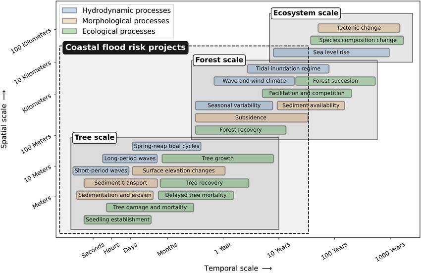
Gijsman et al. Reducing Flood Risk With Mangroves
climate-adaptive strategy to reduce coastal flood risk. In doing 2. FIELD AND REMOTE SENSING
so, mangroves can provide additional values for society while EVIDENCE FOR MANGROVE
implementation and maintenance costs could be substantially
FUNCTIONALITY AND PERSISTENCE
lower compared to hard-engineering infrastructure (Borsje et al.,
2011; Narayan et al., 2016). Biogeomorphic dynamics in mangroves are characterised by
Coastal flood risk management requires reliable systems continuous interactions between hydrodynamic, morphological
providing a predictable functionality with a well-defined and ecological processes (Figure 2). The present state of
persistence. However, the functionality of mangroves is highly a mangrove forest determines its capacity to attenuate
non-linear in relation to forest width (Koch et al., 2009; hydrodynamic energy (i.e., wave and water level reduction)
Montgomery et al., 2019). Also, their persistence is limited by and resulting functionality. Mangrove forest persistence depends
critical thresholds: mangroves may collapse when either impacts on how its present state changes over time, due to morphological
of extreme events (Sippo et al., 2018; Krauss and Osland, 2020), changes (i.e., surface elevation changes relative to sea level) or
or changes in environmental conditions exceed their natural changes in forest composition and extent (i.e., forest structure
tolerance (Friess et al., 2012). Such non-linearities and thresholds changes) resulting from ecological and/or physical processes
to mangrove functionality and persistence complicate efforts to (Figure 3).
incorporate mangroves into coastal flood protection projects. Interactions between hydrodynamic, morphological and
This way, mangroves bring uncertainty into a situation where ecological processes occur across multiple temporal and
failure could endanger lives and livelihoods. spatial scales (Figure 4). This multi-scale interaction is the
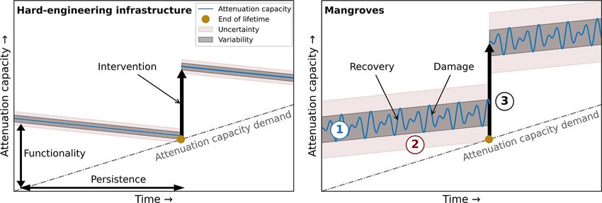
There is a fundamental difference in the variability and consequence of the different scales of the processes determining
uncertainty of functionality and persistence between hard- the attenuation capacity and changes in surface elevation
engineering infrastructure and mangroves (Figure 1). This and forest structure in mangroves. Three scale-levels are
difference necessitates an adaptive management approach. distinguished in these processes: the tree scale, focusing on
Successful design and implementation of mangroves to reduce local short-term dynamics around trees and tree patches; the
coastal flood risk requires (1) a mechanistic understanding of forest scale, considering dynamics of entire transects through
mangrove functionality and persistence, (2) accurate assessments mangrove forests; and the ecosystem scale for the larger-scale
of mangrove functionality and persistence, and (3) identification environmental conditions of the mangroves (Figure 4). In this
of design alternatives to enhance mangrove functionality review, we focus on the tree and forest scales specifically, since
or persistence. For conventional hard-engineering structures, flood risk reduction projects typically consider timescales up
mechanistic understanding, tools and interventions have been to decades and spatial scales within a manager’s jurisdiction.
addressed and distilled in design guidelines that have been Below, we review the relevant processes in mangroves for their
widely applied to manage coastal flood risk (USACE, 2001). functionality and persistence, of which a summarized overview is
By contrast, practical engineering and design guidelines for provided in Figure 3.
flood risk reduction using mangroves, or other NbS, based on
a mechanistic understanding of these systems, have not yet
been developed. This review aims at providing a comprehensive 2.1. Functionality: Wave Attenuation
overview of the context and processes that determine mangrove Capacity
functionality and persistence, which will allow for the definition, The functionality of mangroves to reduce coastal flood risk
quantification and monitoring of locally suitable critical success depends on their capacity to attenuate propagating waves as they
factors for the implementation of mangroves to reduce coastal shoal onshore, thereby progressively reducing hydrodynamic
flood risk. exposure at the shore. Mangroves are exposed to different
The review discusses the functionality and persistence of wave types characterised by their periods: gravity waves (1–
mangroves from the perspective of coastal flood risk reduction. 20 s) such as wind waves; infragravity waves (20 s–5 min);
Firstly, we discuss field evidence for, and the mechanistics of, long-period waves (5 min–12 h) such as tsunamis; ordinary
mangrove functionality and persistence. Secondly, we present tidal waves (12–24 h); and transtidal waves (>24 h) such as
field monitoring and remote sensing techniques to monitor storm surges (Toffoli and Bitner-Gregersen, 2017). In estuaries,
mangrove functionality and persistence. Thirdly, we discuss wave height and period are typically fetch-limited depending
modelling tools that can aid in assessing and predicting on wind direction and system attributes such as scale, bed
the functionality and persistence of mangroves. Fourthly, we elevation, tidal range (Mariotti and Fagherazzi, 2013; Green
provide an overview of available guidelines for engineering and and Coco, 2014), whereas this is not the case on open
management with mangroves and provide an operationalization muddy shores. Different coastal hazards may also generate
of these guidelines following the functionality and persistence different types and combinations of waves; for example, while
approach and the evidence and tools discussed before. Before an earthquake-induced tsunami produces long-period waves,
the conclusion, we discuss remaining challenges that require tropical cyclones may generate a variety of waves such as gravity,
further study to be able to proceed to practical engineering infragravity and transtidal waves simultaneously. Although
and management strategies to reduce coastal flood risk field evidence for the attenuation of shorter-period waves is
with mangroves. increasing, field evidence is still limited for longer-period waves,
Frontiers in Marine Science | www.frontiersin.org 3 July 2021 | Volume 8 | Article 702412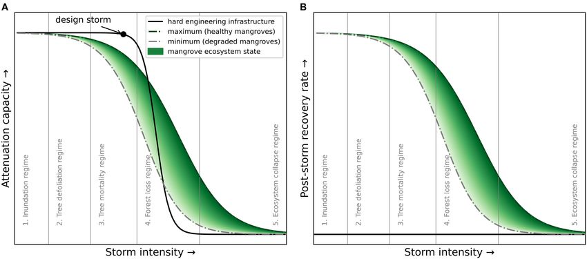
Gijsman et al.                                                                                                                        Reducing Flood Risk With Mangroves

 FIGURE 1 | Variability and uncertainty in reducing flood risk with (A) hard-engineering flood defences and (B) mangroves. The utilization of mangroves requires (1)
 insights in the variability of mangrove functionality and persistence, (2) tools to estimate and predict mangrove functionality and persistence and (3) design alternatives
 that increase mangrove functionality and/or persistence. The attenuation capacity demanded of flood protection infrastructure is expected to increase due to the
 globally increasing flood risk as a result of sea-level rise and increasing human activity in the coastal zone. While mangroves have capacities to adapt to sea-level rise
 (i.e., the attenuation capacity increases gradually), hard-engineering infrastructure cannot (i.e., the attenuation capacity gradually decreases). The figure scales depend
 on the local physical and social circumstances in specific flood risk projects.

 FIGURE 2 | Interacting hydrodynamic, morphological and ecological processes in mangroves determine their functionality and persistence. These interactions are
 also affected by external impacts.

Frontiers in Marine Science | www.frontiersin.org                                    4                                                 July 2021 | Volume 8 | Article 702412
Gijsman et al.                                                                                                              Reducing Flood Risk With Mangroves

 FIGURE 3 | Hydrodynamic, morphological and ecological parameters of processes that determine the functionality and persistence of mangroves. The overlapping
 frames indicate which parameters are included for the attenuation capacity, surface elevation changes and forest structure changes, respectively.

such as for infragravity waves. As a result, the functionality                     height therefore reduces non-linearly after entering mangroves.
of mangroves during high-magnitude flood events is yet to                          However, attenuation rates in mangroves reduce with increasing
be quantified.                                                                     wave period. Because of this preferential attenuation of shorter-
    Previous studies indicate that the functionality of a mangrove                 period waves, mean wave periods have been observed to increase
forest depends on a number of hydrodynamic and biophysical                         across a mangrove forest (Horstman et al., 2014).
attributes: inundation depth, wave height, wave period, flow                          For ordinary tidal and trans-tidal waves, observed attenuation
velocity, intertidal topography, presence of creeks, forest width,                 rates are two orders of magnitude smaller than for gravity
tree species, tree stem density, tree stem diameter and tree height                waves, up to 2 cm per 100 m of mangroves, mainly depending
(Figure 3). Onshore propagating waves transform in shape and                       on the presence of creeks (Krauss et al., 2009; Montgomery
height, depending on subtidal and intertidal morphology. Waves                     et al., 2018). Creeks penetrating mangrove forests provide low-
can increase in height due to shoaling and decrease in height due                  resistance conduits for these long waves, and ordinary tidal waves
to energy losses by bottom friction (i.e., skin friction) and drag                 have been found to even be amplified locally within creeks up to
caused by bed forms or other roughness elements (Green and                         about 110% (Horstman et al., 2021); this study found that high-
Coco, 2014). The presence of mangrove trees imposes additional                     tide water levels within a 850-m long creek were attenuated by up
energy losses and enhances wave attenuation (Mazda et al.,                         to 1.2 cm per 100 m of channel length, whereas rates of up to 3.6
1997a,b). The stems, branches, leaves and characteristic species-                  cm per 100 m were observed in the forest.
dependent aerial roots of mangroves all contribute to form
drag. Additionally, mangroves can (locally) increase levels of                     2.2. Persistence: Surface Elevation
turbulence, especially when flow velocities are high. In this way,                 Changes
they induce additional hydrodynamic energy losses (Furukawa                        Surface elevation changes determine the persistence of mangrove
and Wolanski, 1996; Norris et al., 2017).                                          forests primarily in two ways. Firstly, mangroves can gradually
    For gravity waves, attenuation rates up to 0.012 per m                         become submerged when the rate of surface elevation gain
(i.e., wave height reduces with 1.2% per m) of mangroves                           is not sufficient to keep pace with SLR. The ecosystem-scale
have been observed, depending on the inundation depth, tree                        persistence of mangroves depends on gaining sufficient surface
species and tree density (Mazda et al., 1997a, 2006; Quartel                       elevation to keep up with sea-level rise (i.e., surface elevation
et al., 2007; Horstman et al., 2014). Hence, mangroves can                         capital; Lovelock et al., 2015b). Secondly, surface elevation
substantially reduce gravity wave energy, by up to 75% over a                      changes due to excessive erosion or sedimentation can damage
few tens of meters (Brinkman, 2006; Phuoc and Massel, 2006).                       mangroves at the tree and forest scale when critical thresholds are
Attenuation rates generally increase with wave height. Wave                        exceeded. Instantaneous or gradual submergence increases the

Frontiers in Marine Science | www.frontiersin.org                              5                                             July 2021 | Volume 8 | Article 702412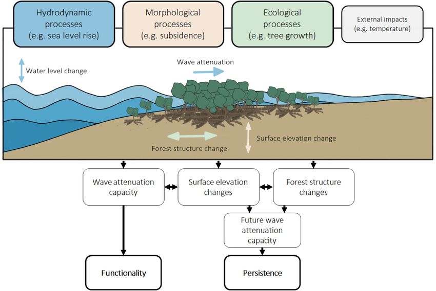
Gijsman et al.                                                                                                               Reducing Flood Risk With Mangroves

 FIGURE 4 | Spatial and temporal scales of interacting hydrodynamic, morphological and ecological processes in mangroves. A distinction is made between the most
 important processes that shape (1) trees and tree patches—tree scale, (2) forests along an elevation gradient—forest scale and (3) entire mangrove
 ecosystems—ecosystem scale. The spatial and temporal scale of coastal flood risk projects typically comprises the tree scale and forest scale.

duration and depth of tidal inundations beyond species-specific                    sediment concentrations (SSC) in the water, tidal inundation
physiological tolerances, and can result in mortality at the tree                  frequency, inundation depth and mangrove forest width
and forest scales (Figure 4). While insights in the persistence to                 (Furukawa and Wolanski, 1996; Horstman et al., 2015; Lovelock
SLR are increasing (Saintilan et al., 2020), limited field evidence                et al., 2015a; Swales et al., 2016; Willemsen et al., 2016). SAR
of tree and forest scale surface elevation changes in a wide range                 also depend on the wave climate (Green and Coco, 2007)
of mangrove settings is available. This shortage of data hampers                   and typically reduce, or even become negative (i.e., erosion),
a comprehensive understanding of the processes determining                         with increasing wave energy (Norris et al., 2021). SAR show a
surface elevation dynamics and their sensitivities and thresholds                  large temporal and spatial variability (Van Santen et al., 2007;
to environmental change.                                                           Smoak et al., 2013; Rogers et al., 2014; Swales et al., 2015, 2019),
   Surface elevation changes in mangroves depend on                                and vary across mangrove species and tree density (Furukawa
hydroperiod, groundwater level, sediment accumulation,                             and Wolanski, 1996; Krauss et al., 2003; Adame et al., 2010;
suspended sediment concentration, soil compaction,                                 Huxham et al., 2010; McKee, 2011; Howard et al., 2020). For
tectonic movements, above- and below-ground biomass                                example, SAR rates varied between 8.3 mm/year (Sonneratia
production/decomposition, growth of algae and microbial mats                       alba) and 11.0 mm/year (Rhizophora spp.) in Micronesia, owing
and leaf litter and detritus accumulation (Figure 3). Mangroves                    to different root structures and their effect on hydrodynamics
are able to increase the surface elevation of their underlying                     (Krauss et al., 2003).
substrate through either mineral-sediment accumulation, in-situ                       Surface elevation changes can also be controlled by surface
production of biomass, or a combination thereof (Krauss et al.,                    and sub-surface biotic contributions. Growth of algae, microbial
2014; Woodroffe et al., 2016; Swales et al., 2019). Sediments                      mats and accumulation of leaf litter and detritus on the
can accumulate in mangrove forests because the sediment                            forest surface can increase the surface elevation directly and/or
carrying capacity of hydrodynamic flows reduces when their                         indirectly by increasing SAR through the resulting increase
velocity reduces due to the enhanced vegetation drag. Sediment                     of surface roughness (Cahoon et al., 2006; McKee, 2011).
accumulation rates (SAR) in mangroves increase with suspended                      In the substrate, biomass production (i.e., root growth) can

Frontiers in Marine Science | www.frontiersin.org                              6                                             July 2021 | Volume 8 | Article 702412
Gijsman et al.                                                                                                 Reducing Flood Risk With Mangroves

increase elevation, while losses have been attributed to biomass            mangrove trees, by smothering the above-ground aerial roots
decomposition (Figure 3; Huxham et al., 2010; McKee, 2011;                  (Sherman et al., 2001; Paling et al., 2008; McKee and Vervaeke,
Lang’at et al., 2014).                                                      2009; Kauffman and Cole, 2010; Radabaugh et al., 2019). Tree
   Lastly, sub-surface physical contributions to surface elevation          species with pneumatophore roots (e.g., Avicennia spp.) or which
changes are soil compaction, ground water level change and                  are unable to sprout from living roots (e.g., Rhizophora spp.) are
tectonic movements (Rogers et al., 2005; Rogers and Saintilan,              particularly vulnerable to rapid sedimentation (Macamo et al.,
2008; Lovelock et al., 2011a, 2015a). Lovelock et al. (2011a) found         2016; Sidik et al., 2016; Asbridge et al., 2018; Imbert, 2018).
lower surface elevation gains in muddy mangroves (1.4 mm/year)                  Mangrove forests can recover from damage to individual
than in sandy mangroves (5.9 mm/year) due to 8 mm/year of                   trees, but recovery rates and success decline with an increasing
mud soil compaction. Sub-surface physical processes also show               scale of damage. Forest recovery depends on tree damage,
large temporal variability. For instance, the desiccation of soil in        (delayed) tree mortality, surface elevation losses, the survival,
higher mangrove areas due to infrequent inundations can lead to             delivery and establishment of seedlings and the forest health
varying soil compaction rates and surface elevation losses in time          (Figure 3). The recovery process of storm-damaged mangroves
(Swales et al., 2019).                                                      can be impeded by post-storm surface elevation losses. Post-
                                                                            storm surface elevation losses can occur in forest gaps, resulting
2.3. Persistence: Forest Structure Changes                                  from tree loss. Rates of post-storm elevation loss of up to 32
The persistence of mangroves also depends on forest structure               mm/year have been reported (Lang’at et al., 2014). Rapid surface
changes at the tree (e.g., tree mortality, inter-species competition)       elevation losses triggered by storms may also impede propagule
and forest (e.g., forest recovery, succession) scales (Figure 4).           establishment and seedling recruitment (Cahoon et al., 2003;
Individual trees and forests can become damaged when external               Vogt et al., 2012; Macamo et al., 2016; Asbridge et al., 2018),
impacts or surface elevation changes exceed certain thresholds:             which is a critical step towards recovery of severely impacted
trees and tree patches can be defoliated, their branches can break          mangroves with high tree mortality (Cahoon et al., 2003; Proffitt
or they can die off due to tree snapping, tree uprooting, burial of         et al., 2006; Zhang et al., 2008). Seedling delivery may already
their aerial roots or tree blowdowns (Swales et al., 2007, 2015;            be minimal after propagules and flowering material is dispersed
Krauss and Osland, 2020). Field evidence of wind impact on                  during tropical cyclones (Steinke and Ward, 1989). The resilience
trees is increasing, but field evidence of tree damage and/or tree          and recovery of mangrove forests are further influenced by the
mortality induced by wave action and associated instantaneous               ecological health and status of a mangrove forest prior to storm
erosion or sedimentation remains very limited. Depending on the             events. For example, deteriorated mangrove forests recover more
extent of the damage and the conditions of the remaining forest,            slowly from severe tree damage caused by storms (Milbrandt
mangrove trees and forests can recover. Ecosystem scale forest              et al., 2006; Harris et al., 2010; Primavera et al., 2016; Walcker
structure changes may also occur, by the adaptation of mangroves            et al., 2019).
to e.g., climatic changes such as changes in temperature or rainfall
(causing a shift in salinity) or migration of mangroves to areas
suitable for seedling establishment.                                        3. MONITORING OF MANGROVE
    Mangrove tree damage and mortality depends on storm                     FUNCTIONALITY AND PERSISTENCE
severity (i.e., inundation depth, wave height, wind speed and
wave forces), storm-event sediment deposition and/or erosion                Measurements are required to assess the functionality and
(i.e., surface erodibility), tree species, density and height               persistence of mangroves and to provide robust field evidence
(Figure 3). Primarily, tree damage in mangroves has been linked             of their contribution to flood risk reduction. A range of field
to the severity of tropical cyclones and the exposure of individual         monitoring and remote sensing techniques are being used to
mangrove trees or stands (Paling et al., 2008; Doyle et al., 2009;          measure hydrodynamic (section 3.1), morphological (section
Smith et al., 2009; Dutta et al., 2015; Feller et al., 2015; Long           3.2) and ecological (section 3.3) processes which are key
et al., 2016; Danielson et al., 2017) in mangrove forests that              for evaluating the functionality and persistence of mangroves
grow along coastlines exposed to cyclonic activity. Tree damage             (Figure 3). While field monitoring typically aims to obtain
has been observed to increase rapidly when wind speeds of                   insights on tree- and forest-scale processes, remote-sensing
tropical cyclones exceed 130 km/h (Imbert, 2018). The exposure              techniques can provide insight on forest- and ecosystem-scale
of mangrove trees to wind-induced structural damage was found               processes (Figure 4).
to increase with increasing tree height (Milbrandt et al., 2006;
Zhang et al., 2008, 2016; Salmo et al., 2013) and decreasing tree
density (Vogt et al., 2012). Tree damage is also species-dependent          3.1. Hydrodynamic Processes and Extreme
(Steinke and Ward, 1989; Sherman et al., 2001; Kauffman and                 Weather Events
Cole, 2010). For example, higher mortality rates have been                  Hydrodynamic measurements in mangroves typically serve
observed for Rhizophora spp., which were unable to self-support             functionality assessments at the tree and forest scales. However,
during large wind speeds (Macamo et al., 2016; Asbridge et al.,             hydrodynamic processes also affect surface elevation changes
2018; Imbert, 2018). Rapid sedimentation and excess leaf litter             and forest structure changes, related to their persistence
(Steinke and Ward, 1989; Castañeda-Moya et al., 2010, 2020;                 (Figure 3). Hydrodynamic processes are often monitored in-
Lovelock et al., 2011b) can also cause delayed mortality of                 situ by deploying field-monitoring equipment along a transect

Frontiers in Marine Science | www.frontiersin.org                       7                                      July 2021 | Volume 8 | Article 702412
Gijsman et al. Reducing Flood Risk With Mangroves
through the mangroves, for periods typically covering days- of the morphology due to sediment transport processes
weeks. Long-term monitoring stations and remote sensing can can provide indicators of its persistence. Both remote-
be used for the monitoring of forest-to-ecosystem scale boundary sensing and field-monitoring techniques have been used to
conditions such as sea level and wave climate. measure geomorphological and sediment transport processes
Inundation depths and periods are typically measured with in mangroves.
autonomous low-frequency pressure sensors, or tide gauges The present state morphology of mangrove forests have
(Mazda et al., 1997a; Phuoc and Massel, 2006; Quartel et al., typically been obtained using remote-sensing of satellite imagery
2007; Horstman et al., 2014; Montgomery et al., 2018; Swales or aerial photogrammetry (e.g., in Krauss et al., 2003; Yuvaraj
et al., 2019). Alternatively, visual or automated observations of et al., 2014, respectively). Bhargava et al. (2021) applied remote
vertically placed staff gauges (Swales et al., 2019) or dyed cotton sensing to observe the extent of the water surface and thus the
ropes (Ferwerda et al., 2007; Lovelock et al., 2015a) have been topography relative to the water level. Additional morphological
used. In addition, wave heights and periods of short-period features, such as the presence of creeks or the intertidal
waves have been measured with high-frequency pressure sensors topography in mangroves, have been obtained with (1) airborne
(Mazda et al., 1997a; Brinkman, 2006; Horstman et al., 2014). In or spaceborne remote-sensing with lidar (Zhang et al., 2008;
contrast to inundation depth measurements, short-period waves Montgomery et al., 2018) or radar (Kuenzer et al., 2011), (2) field-
require a higher frequency (>2 Hz) to measure dynamic pressure scale remote sensing with drones (Beselly et al., 2021) and (3)
differences in the water column. field monitoring with RTK GPS and/or Total Station (Horstman
Flow velocities have been measured with Electro-Magnetic et al., 2015; Leong et al., 2018; Walcker et al., 2019) or levelling
Current (EMC) meters (Mazda et al., 1997a; Quartel et al., 2007; tubes (Quartel et al., 2007; Van Santen et al., 2007). It is generally
Van Santen et al., 2007), Acoustic Doppler Velocimeters (ADV) challenging to obtain topographic measurements in mangrove
and Acoustic Doppler Current Profilers (ADCP) (Horstman forests, as direct measurements are hampered by the dense
et al., 2015, 2021; Willemsen et al., 2016). While the EMC and vegetation and RTK GPS as well as remote sensing are affected
ADV provide the flow velocity at a single point, the ADCP by the tree canopy.
can provide a velocity profile throughout the water column. Sedimentation is measured over a range of time scales, from
Alternatively, downward-looking video cameras have been used events or multiple days up to several months or years. Short-term
to study flow velocities and patterns in mangroves (Furukawa accretion is typically measured using sediment traps, marker
and Wolanski, 1996). The latter technique provides spatial horizons, burial plates, sediment pins or sediment cores. Traps
information on flow velocities at the water surface. are thin canvas or plastic plates (Van Santen et al., 2007; Swales
Ground water levels have been measured by means of the and Lovelock, 2020) or ceramic tiles (Horstman et al., 2015) and
distance between the ground water table and the surface, through marker horizons consist of a white powdered feldspar clay layer
a pressure gauge positioned in a perforated plastic pipe (Rogers (Cahoon and Turner, 1989). They are placed at the surface and
and Saintilan, 2008; Montgomery et al., 2018). Alternatively, from the deposited weight of sediments on the traps, or layer
rainfall measurements from nearby environmental stations have thickness on the markers, surface accretion can be determined.
been used as an indicator for ground water levels (Rogers et al., Burial plates work similarly, but a pin is pushed through the soil
2005; Salmo et al., 2013; Swales et al., 2019). to measure the distance to plate installed at approximately 30
Lastly, forest-to-ecosystem scale parameters such as sea level, cm deep (Balke et al., 2013a). To measure not only accretion,
wave conditions and wind climate have typically been obtained but also erosion, sediment pins have been used. These are steel
from nearby tide gauges, wave buoys or climate stations. pins that are driven approximately 70-80 cm into the soil (Krauss
Complemented by tide gauges, satellite altimetry measurements et al., 2003; Huxham et al., 2010). Surface accretion due to storm
have also been shown to provide accurate measurements of the surge deposition can be measured with cores (e.g., a Russian peat
sea level over greater spatial extents (Church and White, 2011; corer) (Smith et al., 2009; Castañeda-Moya et al., 2010, 2020), in
Watson et al., 2015; Cipollini et al., 2017). Wind and wave which mangrove peat and storm deposits can be differentiated
climate (e.g., Izaguirre et al., 2011; Young and Donelan, 2018; by means of their color. Overall, the above-mentioned weight,
Young and Ribal, 2019) and other essential climate variables can layer thickness or distances are measured either semi-continuous
be obtained from satellite observations (e.g., Hollmann et al., on temporal scales of days-weeks, or intermittent on temporal
2013). Geostationary satellites, such as GOES and MeteoSat, can scales of months-years. The recently developed SED sensor forms
continuously monitor weather conditions and signal (tropical) a promising technique to monitor surface accretion and erosion
depressions. In 2016, NASA’s Cyclone Global Navigation Satellite in mangroves continuously on the timescale of months-years
System (CYGNSS) was launched, which employs a number (Hu et al., 2020).
of micro-satellites to measure (ocean) wind speed to improve In addition to short-term accretion, long-term net
extreme weather prediction (Ruf et al., 2016). sedimentation rates at the surface are determined with Pb10 –
coring. Pb10 – coring is used to study sedimentary processes at
decadal time scales, with dating of sediment deposits up to 100
3.2. Morphology and Sediment Transport years old (Quartel et al., 2007; Smoak et al., 2013; Swales et al.,
Processes 2015).
The present state morphology is an important indicator for the Substrate elevation changes due to subsurface processes have
functionality of a mangrove forest, whereas temporal changes been measured in the field, with surface elevation tables (SET)
Frontiers in Marine Science | www.frontiersin.org 8 July 2021 | Volume 8 | Article 702412Gijsman et al. Reducing Flood Risk With Mangroves
and more recently rod surface elevation tables (RSET, Cahoon structure changes are important for their persistence. Mangrove
et al., 2002b), and with satellite remote sensing. SETs and RSETs forest structure has widely been measured by remote sensing.
consist of a horizontal reference attached to a steel rod that In addition, field monitoring has been performed to obtain tree
is driven into the sediment down to the bedrock or to refusal scale measurements of relevant ecological processes. Forest width
(typically 10–25 m). Through the horizontal reference, fibre- can be obtained from aerial photographs (e.g., Vogt et al., 2012)
glass pins can manually be lowered to measure the distance or satellite imagery (e.g., Long et al., 2016). These techniques
to the surface (Cahoon et al., 2002a). The benefit of SETs and can also provide additional insights on mangrove functionality
RSETs is that they do not disturb the surface sediments and through forest species composition, but additional field work
provide measurements of both mean and spatial variability in may be required for ground referencing (e.g., Van Santen et al.,
surface elevation changes at the tree scale. To obtain surface 2007). Direct measurements are performed at the tree scale,
elevation changes both at the surface and in the substrate, the typically by determining tree species, tree density, tree stem
RSET approach is usually combined with the marker horizon diameter, tree height and tree roots of representative trees in plots
(MH) technique. This way, the RSET-MH has become a widely along a transect (e.g., Krauss et al., 2003; Horstman et al., 2014;
applied methodology to measure elevation changes in mangroves Howard et al., 2020). Obtaining tree-scale data in support of
(Webb et al., 2013; Cahoon, 2015). SET or RSET readings of mangrove functionality is labour intensive as measurements are
surface and substrate elevation changes are typically collected generally made visually and/or manually. There are efforts being
at intervals of months to years. Alternatively, satellite remote made to automize this data collection through photogrammetry
sensing (radar interferometry) has been used to detect ecosystem- (Liénard et al., 2016) or laser scanning, though still requiring
scale subsidence (Chaussard et al., 2013). active ground data collection.
Sediment supply (for accretion) largely depends on suspended Ecological processes are an indicator for the persistence of
sediment concentrations (SSC) and hydroperiod. Measurements mangroves, since they can affect both the surface elevation and
of SSC have been obtained from water samples (Furukawa the forest structure. Tree-scale processes such as tree growth,
and Wolanski, 1996; Adame et al., 2010) or indirectly from root growth, growth of algae or microbial mats and accumulation
optical backscatter sensors (Phuoc and Massel, 2006; Van of leaf litter and detritus are also typically obtained from
Santen et al., 2007; Balke et al., 2015) or acoustic backscatter field surveys. Tree growth has been measured with manual or
sensors (Horstman et al., 2015; Venditti et al., 2016). It can recording dendrometer bands (i.e., stainless-steel bands which
be challenging to obtain reliable SSC measurements from are placed around the tree stem) (Krauss et al., 2007; Lovelock
optical and acoustic sensors, because they require calibration et al., 2011b; Vilas et al., 2019) or by tagging and re-measuring
in controlled environments, which greatly depends on the individual trees (Feller et al., 2015). Root growth has been
type, size and colour of the sediment (Hoitink and Hoekstra, measured with root ingrowth bags (Cahoon et al., 2003; Lovelock
2005; Downing, 2006). Alternatively, river discharge (Swales et al., 2011a; McKee, 2011). These nylon mesh bags are filled
et al., 2019) or turbidity (Lovelock et al., 2015a) have been with natural sediments, buried at the field site and later collected
used as proxies for SSC and/or sediment supply. In turn, to measure the produced root biomass. The growth of algae or
turbidity can be estimated from differences in water color on microbial mats at the surface may affect surface elevation change
satellite imagery complemented with Secchi disk measurements and can be measured from cut pneumatophore roots (Steinke and
(Gillis et al., 2017). Ward, 1989) or by constructing surface screens (McKee, 2011).
While measurements of surface elevation changes are The obtained samples can be analysed for organic matter or
abundant, there is limited knowledge of surface erosion in Chlorophyll-a content (i.e., a proxy for algal biomass) (Horstman
mangrove forests. The erodibility of the surface depends on a et al., 2018). Lastly, the contribution of leaf litter or detritus
threshold bed shear stress: the critical shear stress for erosion (τe ) accumulation to surface elevation changes can be measured by
and an erosion-excess bed shear stress gradient (M). M indicates using litter baskets (Steinke and Ward, 1989; Castañeda-Moya
how quickly erosion rates increase when the critical bed shear et al., 2010, 2020; Gladstone-Gallagher et al., 2016; Danielson
stress is exceeded. Both (τe ) and M can be measured with the et al., 2017).
EROMES device (Stokes and Harris, 2015; Nguyen et al., 2019, The global distribution of mangrove forests have been mapped
2020). By gradually increasing the rotational speed of a propeller using optical and radar satellite remote sensing (Giri et al., 2011;
in the EROMES tube, the flow velocity and exerted bed shear Bunting et al., 2018). Forest- and ecosystem-scale persistence
stress at the surface of the sediment sample in the tube follow. of mangroves has widely been studied with remote sensing, by
Thereafter, (τe ) and M can be derived from the measurement of monitoring forest structure changes due to tree damage and/or
the turbidity in the tube (Stokes and Harris, 2015). Alternatively, forest recovery in response to extreme weather events (Paling
the surface erodibility has been determined through the soil shear et al., 2008; Doyle et al., 2009; Vogt et al., 2012; Long et al., 2016;
strength measured with a shear vane (McKee and Vervaeke, Macamo et al., 2016; Zhang et al., 2016; Walcker et al., 2019).
2009). However, no direct relation between this soil shear These remote sensing studies typically relate forest structure
strength, (τe ) and M has been derived to date. to parameters such as the leaf area index (LAI) (Salmo et al.,
2013; Feller et al., 2015), the normalized differential vegetation
3.3. Forest Structure and Ecological index (NDVI) (Long et al., 2016; Macamo et al., 2016; Walcker
Processes et al., 2019; Goldberg et al., 2020), the enhanced vegetation
Forest structure (i.e. width, composition, density) largely index (EVI), the land surface temperature (LST) or the foliage
determines the functionality of mangroves. Hence, forest projective cover (FPC) (Dutta et al., 2015; Asbridge et al., 2018).
Frontiers in Marine Science | www.frontiersin.org 9 July 2021 | Volume 8 | Article 702412Gijsman et al. Reducing Flood Risk With Mangroves
Ground referencing is required to translate these indices into have been classified (Thom, 1984; Woodroffe, 1992; Worthington
forest structure information. Lymburner et al. (2020) obtained et al., 2020).
long-term (decades) annual mangrove cover from optical satellite At the smaller forest scale, mangroves consist of different
data complemented by lidar data. Zhang et al. (2016) concluded topographic zones with characteristic species compositions,
that the normalized differential moisture index (NDMI) provides across for example fringe, riverine, overwash, basin and dwarf
a sound indicator to assess mangrove forest structure changes. mangroves (Lugo and Snedaker, 1974). Topographic zones are
Recent remote sensing approaches have even managed to detect often based on their respective distances to a river or open ocean,
tree species and tree height from space-borne images (Pham but they are typically also characterised by differences in tree
et al., 2019; Wang et al., 2019), and to estimate tree biomass species, density, height, elevation, tidal inundation regime and
from drone images (Jones et al., 2020). Simard et al. (2019) used exposure to waves. Tidal inundation regime is a key control on
SRTM SAR data, together with spaceborne lidar data, to map tree species (Van Loon et al., 2016). Alternatively, topographic
the maximum canopy height of mangroves worldwide. These zones in mangroves have been named after the type of trees: scrub
tree- and forest-scale insights on mangrove forest structure are or mature forest (Adame et al., 2010).
particularly helpful to assess the functionality and persistence of To standardize the application of mangroves to reduce flood
mangroves (Figure 4). risk, tree scale parameters such as species, height and diameter
need to be classified/generalized. Common mangrove species
are from the following genera: Avicennia, Rhizophora, Bruguira,
4. MODELS OF MANGROVE Sonneratia and Xylocarpus (Spalding et al., 2010). They are
FUNCTIONALITY AND PERSISTENCE characteristised by different types of aerial root systems, such as
pneumatophores for Avicennia, stilt roots for Rhizophora, knee
Models are essential in predicting and assessing the functionality roots for Bruguiera and plank roots for Xylocarpus. Tree height
and persistence of mangroves. Firstly, classification models are and diameter can be used to distinguish between seedlings (dbh
required to categorize mangroves for implementation in flood < 2.5 cm), saplings (height < 1.3 m and dbh < 5 cm) and adults
risk management (section 4.1). Secondly, empirical (section 4.2) (height > 1.3 m or dbh > 5 cm) (Vogt et al., 2012; Salmo et al.,
and numerical (section 4.3) mangrove models can be used to 2013), but also other thresholds or sub-classes have been used
simulate extreme flooding conditions (functionality), and to (e.g., Ferwerda et al., 2007; Radabaugh et al., 2019).
predict their long-term development (persistence) to assess the Lastly, important qualitative parameters to standardize for
consequences of environmental and human-induced changes. flood risk reduction are the tree damage, forest development
While classification models for mangroves have been widely and gap recovery. Tree damage has been classified with a variety
applied, the development of empirical and numerical models of classification models at different scales (Table 1; Smith et al.,
with predictive skill is an active field of research (e.g., Peters 1994; Sherman et al., 2001). For instance, Smith et al. (1994)
et al., 2020; Buffington et al., 2021). For instance, first numerical distinguishes between: (1) no damage, (2) partial damage (75% defoliation, trees fallen), (5)
Willemsen et al., 2016), but are lacking ecological processes total damage (>50% of trees fallen) and (6) catastrophic damage
such as tree growth and mortality. In contrast, mangrove forest (>75% of trees fallen). Duke (2001) considered a classification
growth models (e.g., Grueters et al., 2019) typically disregard model for forest development and recovery, while Whelan (2005)
morphological processes, while models for the morphological discussed several conceptual gap recovery stages (Table 1).
evolution of mangroves (e.g., Buffington et al., 2021) disregard
hydrodynamic processes such as waves. 4.2. Empirical Models
Empirical models are basic quantitative assessments of the
functionality and persistence of mangroves, mostly focusing
4.1. Classification Models on the forest scale. Empirical models are particularly useful
Classification models aim at obtaining first qualitative for preliminary assessments, when system knowledge is still
assessments of the functionality and persistence of mangroves incomplete (Table 2). Initial empirical models on the forest-scale
by categorizing qualitative dimensionless parameters such functionality of mangroves relate wave attenuation in mangroves
as the biophysical setting and tree species. Classification to a specific wave attenuation rate r. For short-period waves, an
models are applicable on ecosystem, forest and tree scales exponential decay in wave height H along a transect through
(Table 1). The biophysical setting of mangroves indicates mangroves was found (Table 2; Mazda et al., 2006). To estimate
the geomorphic setting as well as the dominant sedimentary the attenuated wave height at a given location, the relation
processes (Worthington et al., 2020). In terms of sedimentary requires the incident wave height at the open/unvegetated
settings, mangroves can be classified as either terrigenous or boundary of the forest H0 and the distance inland of the forest
carbonate. Terrigenous mangroves represent the majority of the fringe x. Wave attenuation rates for short-period waves have been
world’s mangrove cover and are dominated by fluvial sediment observed of approximately 0.001–0.01 (see Table 1 in Horstman
supply. In contrast, sediments in carbonate mangroves mainly et al., 2014). For longer-period waves, a linear decay in the
come from calcareous sedimentation. In terms of geomorphic inundation depth h along a transect through the mangroves was
settings, deltaic, estuarine, lagoonal and open coast mangroves found (Krauss et al., 2009). Similar to attenuation of short-period
Frontiers in Marine Science | www.frontiersin.org 10 July 2021 | Volume 8 | Article 702412Gijsman et al. Reducing Flood Risk With Mangroves
TABLE 1 | Existing classification models for the categorization of mangroves in flood risk management.
Scale Parameter Classes References Scope
Ecosystem Sedimentary setting (1) Terrigeneous Worthington et al., 2020 Persistence
(2) Carbonate
Geomorpic setting (1) Deltaic Worthington et al., 2020 Functionality and Persistence
(2) Estuarine
(3) Lagoonal
(4) Open coast
Forest Forest zonation (1) Fringe Lugo and Snedaker, 1974 Functionality and Persistence
(2) Riverine
(3) Overwash
(4) Basin
(5) Dwarf
Forest development (1) Colonisation Duke, 2001 Persistence
(2) Development
(3) Maturity
(4) Senescence
Forest damage (1) No Smith et al., 1994 Persistence
(2) Partial
(3) Major
(4) Severe
(5) Total
(6) Catastrophic
Tree Tree species (1) Avicennia Spalding et al., 2010 Functionality and Persistence
(2) Rhizophora
(3) Bruguira
(4) Sonneratia
(5) Xylocarpus
Root type (1) Pneumatophore Spalding et al., 2010 Functionality and Persistence
(2) Stilt
(3) Knee
(3) Plank
Tree height or diameter (1) Seedlings Salmo et al., 2013 Functionality and Persistence
(2) Saplings
(3) Adults
Tree damage (1) No damage Doyle et al., 2009 Persistence
(2) Partial damage
(3) Total damage
Tree gap recovery (1) New Whelan, 2005 Persistence
(2) Recruiting
(3) Growing
These models provide qualitative insights to be taken into account in mangrove functionality and persistence assessments.
waves, this equation requires the inundation depth at the open Additional empirical relations have been established to
boundary of the forest h0 and the related distance inland x. For estimate forest-scale functionality, including the tree-scale
long waves, observed attenuation rates ranged between 4.21·10−5 characteristics of mangroves explicitly. Firstly, attenuation rates
and 9.45 · 10−5 (Krauss et al., 2009). have been related to the volume of the mangrove vegetation per
Frontiers in Marine Science | www.frontiersin.org 11 July 2021 | Volume 8 | Article 702412Gijsman et al. Reducing Flood Risk With Mangroves
TABLE 2 | Existing empirical models for preliminary quantitative assessments of mangrove functionality and persistence.
Functionality Equation References
Wave attenuation H(x) = H0 · e−r·x Mazda et al. (2006)
Inundation attenuation h(x) = h0 − r · x Krauss et al. (2009)
Wave attenuation rate r = c1 · ρveg + c2 Horstman et al. (2014)
−1
Wave attenuation H(x) = H0 · 1 + C32·
D ·π·H
√ 0 ·x
2·h2
Mazda et al. (1997a)
δh CD A/V 2
Inundation attenuation δx = 2g · 1−VM /V · u Mazda et al. (1997b)
0.15·A
Drag coefficient CD (A) = 0.6 · e Quartel et al. (2007)
Persistence
w0 ·x
Sediment accumulation SAR(x) = SSC0 · w0 · e h·u Furukawa and Wolanski (1996)
Sediment accumulation SAR = 1Z · x · S Clough et al. (2010)
c3
Basal area loss 1a = Imbert (2018)
1+c4 ·e−c5 ·Wmax
Forest damage Minimal, if –0.3 < 1NDVI < –0.2 Long et al. (2016)
Moderate, if –0.5 < 1NDVI < –0.3
Severe, if 1NDVI < –0.5
Forest damage No damage, if 0.4Gijsman et al. Reducing Flood Risk With Mangroves
(
height, h is the inundation depth and Hrms is the root-mean- ws · SSC if τb < τd
DR = (5)
square wave height. This formulation is currently implemented in 0 otherwise
numerical wave models such as SWAN (Booij et al., 1999; Suzuki
et al., 2012) and XBeach (Roelvink et al., 2009). An example of Herein, ER is the erosion rate, M is the erodibility of the bed,
a numerical study of short-wave attenuation in mangroves with τb is the bed shear stress exerted by the flow and τe is the
Equation 1 is the study of van Wesenbeeck et al. (2016). critical bed shear stress for erosion, DR is the deposition rate,
In contrast, propagation of long-period waves (>20 s) is ws is the settling velocity of the sediment, SSC is the suspended
simulated by solving the non-linear shallow water equations sediment concentration and τd is the critical bed shear stress for
(continuity and momentum). In numerical models that simulate deposition. The Partheniades-Krone equations do not explicitly
the propagation of longer-period waves (e.g., Delft3D, Telemac) include the effects of mangroves on erosion or sedimentation.
the effects of mangroves have been implemented in the Instead, erosion (and resuspension) in mangroves is reduced
momentum equation in two different ways: (1) by increasing the because of a reduced bed shear stress exerted by the flow (τb ),
bed roughness and (2) by including an additional momentum induced via the reduction in flow momentum.
loss term. The first approach increases the actual bed shear The stabilizing effects of mangrove roots on the erodibility
stress due to surface roughness (τb ) with a vegetation roughness of the bed were included in the approach of Van Maanen et al.
component (τv ) (c.f. Gourgue et al., 2020). The second approach (2015), by increasing the critical threshold for erosion τe based
reduces the flow momentum with a drag term based on on the presence of below-ground mangrove biomass (Equation
vegetation properties such as density, diameter, height and 6). Their model also accounted for reduced subsidence 1Zorg
drag coefficient (c.f. Brückner et al., 2019). The flow resistance based on a relation with the below-ground biomass (Equation
concept is generally favoured in morphological simulations since 7). Hence, they artificially increased the erosion threshold and
an artificially increased bed roughness may result in over- decreased the subsidence when mangroves were present, but no
estimations of bed shear stresses τb and hence of erosion rates calibration or validation of this model was provided.
(section 4.3.2 and Equation 4).
While the vegetation roughness (of fully submerged Bb
τe = τe,0 · (1 + Kcr · ) (6)
vegetation) is typically calculated with the formulation of Baptist Bb,mature
et al. (2007) (Equation 2), the flow resistance coefficient λ
for emergent vegetation can be calculated with Equation 3
Bb
(Deltares, 2020). 1Zorg = Korg · (7)
Bb,mature
1
τv = · ρ · CD · N · D · h · u 2 (2) Herein, τe,0 is the critical bed shear stress for erosion when
2
no mangroves were present, Kcr is a constant of 0.1, Bb is
λ 2 1 the below-ground biomass, Bb,mature is the maximum below-
− · u = − · CD · N · D · u 2 (3) ground biomass (1.2 kg/m2 ) and Korg is a constant of 1 mm/year
2 2
(Van Maanen et al., 2015).
Zhang et al. (2012) and Menéndez et al. (2019) followed the Model studies on the ecosystem-scale persistence of
artificial roughness approach by increasing the bed roughness mangroves typically consider relative sea-level rise (i.e., the
coefficients (i.e., the Manning coefficient) from 0.04 to 0.14 change in elevation of the forest floor with respect to the sea
to compensate for the presence of mangroves. The studies of level), in response to absolute sea-level rise scenarios (IPCC,
Horstman et al. (2015) and Willemsen et al. (2016) describe tidal 2019). Instead of solving sediment transport processes, these
wave propagation and sedimentation in mangroves applying the model approaches typically calculate surface elevation changes
flow resistance approach, where the physical properties of the based on the annually-averaged hydroperiod (e.g., SLAMM).
mangroves are accounted for. Buffington et al. (2021) also included the effects of leaf litter
deposition, root decomposition and soil compaction, all
4.3.2. Surface Elevation Changes and Sediment primarily related to the present species composition, on surface
Transport Processes elevation changes in mangroves.
Surface elevation changes occurring due to surface dynamics
(e.g., sedimentation) and sub-surface processes (e.g., subsidence) 4.3.3. Forest Structure and Ecological Processes
are generally solved with separate numerical approaches. For Numerical models to simulate forest structure changes in
instance, the above-mentioned hydrodynamic models include mangroves generally distinguish between seedlings and trees.
sediment transport processes and resulting sediment deposition While seedling establishment models relate the establishment of
or erosion, but no sub-surface processes. A widely applied seedlings to hydrodynamic and morphological processes, tree
approach to calculate erosion and deposition rates of cohesive development models aim to simulate the tree life cycle including
sediments are the Partheniades-Krone equations (Equations 4, growth, competition and mortality.
5 for erosion and deposition, respectively). The Windows of Opportunity (WoO) model quantifies three
( critical sequential life stages of seedlings: propagule delivery
M · ( ττbe − 1) if τb > τe and root anchoring; seedling establishment; and seedling growth
ER = (4)
0 otherwise and survival (Balke et al., 2013b). Although propagule delivery
Frontiers in Marine Science | www.frontiersin.org 13 July 2021 | Volume 8 | Article 702412You can also read