STRENGTHENING COMMUNITY AND ECOSYSTEM RESILIENCE AGAINST CLIMATE CHANGE IMPACTS - Vietnam Case Study from Field Testing an Operational Framework ...
←
→
Page content transcription
If your browser does not render page correctly, please read the page content below

STRENGTHENING COMMUNITY AND ECOSYSTEM
            RESILIENCE AGAINST CLIMATE CHANGE IMPACTS
            Vietnam Case Study from Field Testing an Operational Framework
                            for Ecosystem-based Adaptation

                                    Hanoi, 2013
© Vũ Long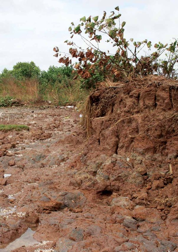
Project name		 “Strengthening Community and
                			            Ecosystem Resilience against Climate
                			            Change Impacts: Developing a
                			Framework for Ecosystem-based
                			            Adaptation in Lao PDR and Viet Nam”,
                			            study in Viet Nam

                Project partners		     ISPONRE, DONRE of Ben Tre, WWF

                Citation			 ISPONRE, DONRE of Ben Tre, WWF, 2013.
                			Viet Nam Case Study from Field
                			         Testing an Operational Framework for
                			Ecosystem-based Adaptation

                Project team		 Raji Dhital
                			Barbara Pollini
                			Kim Thi Thuy Ngoc
                			Le Thi Le Quyen
                			Doan Van Phuc
                			Nguyen Thi Thuy
                			Hoang Viet
                			Tran Thi Mai Huong
                			Tran Trung Kien
                			Dang Thanh Ha

                Project sponsored by   The World Bank-Netherland Partnership Program

                Contact			 The Institute of Strategy and Policy on
                			        Natural Resources and Environment
                			        No 479 Hoang Quoc Viet Street,
                			Ha Noi,
                			Viet Nam
                			Tel: 844.37931627
                			www.isponre.gov.vn
                			and
                			WWF-Viet Nam
                			        D13, Thang Long International Village,
                			        Cau Giay district, Hanoi,
                			Viet Nam
                			        Tel.: +84 4 37193049
©WWF-Viet Nam

                			www.panda.org/greatermekong.org

Table of contents
List of abbreviations										6
Technical terms											7
List of tables											9
List of maps											10
List of figures											11

1. Introduction											12
          1.1. Background for the case study								12
          1.2. Study Area										13

2. Methodology											15
       2.1. Conceptual Framework								15
       2.2. Methods										17
		2.2.1. Secondary research and analysis						17
		              2.2.2. Stakeholder Consultation including community representatives			                17
		2.2.3. Focus Group Discussion							17
		2.2.4. Seasonal Calendar								18
		2.2.5. Historic climate Trend analysis							18
		2.2.6. Participatory mapping							18
		2.2.7. Scenario Analysis								18
		              2.2.8. Scenario analysis involving modeling tools for future vulnerability assessment 18
		2.2.9. Expert Judgment								20
		2.2.10. Vulnerability Matrix							20
		2.2.11. Multi-Criteria Analysis							20
		2.2.12. Cost effectiveness analysis							21

3. Understanding the local context								22
         3.1. Framing and Setting the Context for Analysis						        22
		3.1.1. Setting up a social ecological system:						22
		3.1.2. Geographic context								23
		3.1.3. Socio-Economic Context							23
3.2. Recent and Historic Climate Change Patterns							                 25
3.3. Ecosystem Services and their Importance to Local Livelihoods 					 26

4. Results of vulnerability analysis
        4.1. Current climate and development pressures to communities and ecosystems			          30
		                4.1.1. Current climate pressures to communities and ecosystems			              30
		                4.1.2. Current development pressures on to communities and ecosystems		        32
        4.2. Threats from Future Climate and Development Pressures to Communities and Ecosystems 33
		4.2.1. Climate Change								33
		4.2.2. Development activities							36
        4.3. Summary of current and future pressures onto communities and ecosystems			          37
        4.4. Integrated risk assessment of ecosystem dependent livelihood activities			          38
        4.5. Community Developed Indicators for Vulnerability/Resilience				                     40
        4.6. Assessing Exposure, Sensitivity and Adaptive Capacity					                          42
        4.7. Current Coping Strategies to Climate and Non-Climate Related Hazards			             44
        4.8. Scenario Development and Reflection							46

4 | Vietnam Case Study from Field Testing an Operational Framework for Ecosystem based Adaptation
4.8.1. Business as Usual Scenario in 2020						46
		4.8.2. Development Scenario in 2020						47
		4.8.3. Conservation Scenario in 2020						48
  4.9. Future Scenarios and Use of Models to Assess Future Vulnerability				 49
		4.9.1. Coastal Vulnerability								49
		         4.9.2. Coastal protection – Near shore wave erosion					          51
		4.9.3. Carbon Storage and Sequestration						52
		4.9.4. Conclusions									57

5. Discussion on Adaptation Measures								59
        5.1. Identifying Adaptation Measures							59
        5.2. Prioritizing adaptation strategies - Cost effectiveness analysis (CEA)				 62
		5.2.1. Financial Cost effectiveness analysis						62
		                5.2.2. Estimation of Economic Value of Ecosystems Services				        63
		                5.2.3. Cost Effectiveness Analysis (CEA) of CC adaptation options				 65
		5.2.4. Conclusions and Recommendations of CEA					66
		                5.2.5. Limitations of the cost effectiveness analysis					            68

6. Finding conclusions and recommendations for EbA integration into policy development process 69

References											72

                                                 Vietnam Case Study from Field Testing an Operational Framework for Ecosystem based Adaptation | 5
List of abbreviations
ADB 		                     Asian Development Bank

CC 		                      Climate Change

CBD 		                     Convention on Biological Diversity

CEA		                      Cost-Effectiveness Analysis

DARD		                     Department of Agriculture and Rural Development

DONRE                      Department of Natural Resources and Environment

DOT		                      Department of Transportation

DPI		                      Department of Planning and Investment

EbA 		                     Ecosystem-based Adaptation to Climate change

FGD		                      Focus Group Discussion

GIZ 		                     German International Cooperation and Development Agency

GMS		                      Greater Mekong Sub-Region

IMHEN		                    Institute of Meteo-hydrology and Environment

InVEST                     Integrated Valuation for Environmental Services and Trade-offs

IPCC 		                    Inter-Government Panel on Climate Change

ISPONRE                    Institute of Strategy and Policy on Natural Resources and Environment

IUCN		                     International Union on Conservation of Nature

MARD		                     Ministry of Agriculture and Rural Development

MONRE                      Ministry of Natural Resources and Environment

MOT		                      Ministry of Transportation

MPI 		                     Ministry of Planning and Investment

M&E 		                     Monitoring and Evaluation

MCA 		                     Multi-criteria Analysis

NTP-RCC                    National Target Program to Respond to Climate change

PPC		                      Provincial People’s Committee

SEDP		                     Socio-Economic Development Plan

SID 		                     Swedish International Development Agency

SP-RCC                     Support Program to Respond to Climate Change

SWOT		                     Strengths, Weakness, Opportunities, Threats

UNCC                       United Nation Convention on Combating Desertification

UNFCC                      United National Framework Convention on Climate Change

WB 		                      World Bank

WWF 		                     World Wide Fund For Nature

6 | Vietnam Case Study from Field Testing an Operational Framework for Ecosystem based Adaptation
Technical terms
Adaptation: The adjustment in natural or human                       areas may be most exposed to drought.
systems in response to actual or expected climatic
                                                                     Hazard: A hazard is defined as a harmful event
stimuli or their effects, which moderates harm or
                                                                     that affects communities or ecosystems. A climate
exploits beneficial opportunities (IPCC 2001).
                                                                     hazard is an event cause by climatic changes with
Adaptive Capacity: The ability of a system to adjust                 the potential to cause harm, such as heavy rainfall,
to climate change (including climate variability and                 drought, storm, or long-term change in climatic
extremes) to moderate potential damages, to take                     variables such as temperature and precipitation.
advantage of opportunities, or to cope with the
                                                                     Multi Criteria Analysis (MCA): A structured
consequences (IPCC 2001). Adaptive capacity of
                                                                     approach used to determine overall preferences
individuals and communities are shaped by their
                                                                     among different alternative options, where the
access and control to important resources and
                                                                     options accomplish several objectives that may
assets, such as access to land, access to water etc.
                                                                     not always complement one another (Department
Climate Change: Changes in climate over a pro-                       for communities and local government, London
longed time. The IPCC (2011) defines climate change                  2009). In MCA, desired objectives are specified and
as a change caused by natural internal processes                     corresponding attributes or indicators are identified.
or external forcings, or by persistent anthropogenic                 The measurement of these indicators is often based
changes in the composition of the atmosphere or                      on a quantitative analysis (through scoring, ranking,
land use.                                                            and weighting) of a wide range of qualitative impact
                                                                     categories and criteria.
Climate Impacts: The consequences of climate
change or climate hazards on natural and human                       Risk: The likelihood of a hazard happening that will
systems.                                                             affect natural or human systems.
Ecosystem-based Adaptation: is “the use of                           Scenario analysis: A method that describes the
biodiversity and ecosystem services as part of an                    logical and internally consistent sequence of events
overall adaptation strategy to help people to adapt to               to explore how the future might, could, or should
the adverse effects of climate change” (CBD 2013).                   evolve from the past and present (van der Sluijs et
Ecosystem-based Adaptation uses sustainable                          al. 2004).
management, conservation, and restoration of
                                                                     Sensitivity: The degree to which the community
ecosystems to build resilience and decrease the
                                                                     is affected by climatic stresses. Communities
vulnerability of communities in the event of climate
                                                                     dependent on rain-fed agriculture are much more
change.
                                                                     sensitive to changes in rainfall patterns than ones
Ecosystem services: Benefits that people obtain                      where the main livelihood strategy is labor in a mining
from ecosystems. These include provisioning                          facility, for instance.
services such as food, water, timber, and fiber;
                                                                     Spatial analysis: A set of methods whose results
regulating services that affect climate, floods, disease,
                                                                     change when the locations of the objects being
wastes, and water quality; cultural services that
                                                                     analyzed change (Longley et al. 2005).
provide recreational, aesthetic, and spiritual benefits;
and supporting services such as soil formation,                      Spatial planning: A method used to influence the
photosynthesis, and nutrient cycling (Millennium                     future distribution of activities in space (European
Ecosystem Assessment 2005).                                          Commission 1997). It goes beyond traditional land-
                                                                     use planning to integrate and bring together policies
Exposure: The level at which a country/region
                                                                     for the development of land-use and other policies
experiences the risks of climate change based
                                                                     and responses that influence the use of land (Office of
on its geographic location. For example, coastal
                                                                     Disaster Preparedness and Management, UK 2005).
communities will have higher exposure to sea level
                                                                     Spatial planning is critical for delivering economic,
rise and cyclones, while communities in semi-arid
                                                                     social, and environmental benefits by creating more

                                                           Vietnam Case Study from Field Testing an Operational Framework for Ecosystem based Adaptation | 7
stable and predictable conditions for investment and                                            of the character, magnitude, and rate of climate
development, by securing community benefits from                                                variation to which a system is exposed, its sensitivity,
development, and by promoting prudent use of land                                               and its adaptive capacity. In EbA the ecosystems
and natural resources for development.                                                          and their vulnerabilities are included in the analysis
                                                                                                together with the vulnerability of communities.
System dynamics: An aspect of systems theory
used to understand the dynamic behavior of complex
systems. The basis of the method is the recognition
that the structure of any system-and the many circular,
interlocking, sometimes time-delayed relationships
among its components-is often just as important in
determining the system’s behavior as the individual
components themselves.
Vulnerability: “The degree to which a system is
susceptible to, or unable to cope with the adverse
effects of climate change, including climate variability
and extremes (IPCC 2001).” Vulnerability is a function

8 | Vietnam Case Study from Field Testing an Operational Framework for Ecosystem based Adaptation
List of tables                                                                                                               Page

Table 1. Field-Testing the Steps of the Framework						                                        16
Table 2. Administrative characteristics of Binh Dai, Ba Tri, and Thanh Phu districts
        of Ben Tre province, Viet Nam								23
Table 3. Agricultural and fishery production in Binh Dai, Ba Tri, and Thanh Phu districts
        of Ben Tre province, Viet Nam								24
Table 4. Key livelihood activities and ranking of dependence on the key ecosystems		           28
Table 5. Rating the impacts of climate-related hazards to the ecosystems and its dependent
        livelihoods by communities (Binh Dai/Ba Tri/Thanh Phu)                                 31
Table 6. Projected climatic trends in the Mekong Delta in the next three decades 			           33
Table 7. Rating of coastal communities in 3 districts (Binh Dai/Ba Tri/Thanh Phu) on impacts
        of development activities on ecosystems and their livelihoods				                      36
Table 8. Risk ranking of key ecosystems/habitats of three coastal communes in Ben Tre province 37
Table 9. Integrated assessment of climate change and development pressures and hazards
        on key ecosystem dependent livelihood activities						39
Table 10. List of Resiliency Indicators for Evaluating Vulnerability of Communities			         41
Table 11. Adaptive capacity ranking								42
Table 12. Current Coping and Adaptation Activities to Climate Change Impacts in Three Coastal
        Districts, Ben Tre (Source: WWF field data, 2013)                                      45
Table 13. Area statistics area of main land cover types of 3 scenarios (Unit: Ha)              49
Table 14. Recommendation for Future Adaptation Strategies to Projected Climate Related
        Risks in the Coastal Districts of Ben Tre Province (Source: WWF field data, 2013)      59
Table 15. Proposed Adjustments to Behavior and Process to Address increasing Development
        Pressures in Ben Tre Province (Source: WWF, field data 2013)                           60
Table 16. Operating Cost of the Sea Dike System in Thanh Phu District				                      62
Table 17. Major economic values of the ecosystem services of one hectare mangrove forest       64
Table 18. Cost effectiveness analysis for low climate change risk with short-term
        adaptation options (10 year horizon)                                                   65
Table 19. Cost effectiveness analysis for high climate change risk with long-term adaptation
        options (30 year horizon)                                                              66
Table 20. Cost effectiveness of short and long-term climate change adaptation options
        in Ben Tre province under different interest rates						                               66

                                                 Vietnam Case Study from Field Testing an Operational Framework for Ecosystem based Adaptation | 9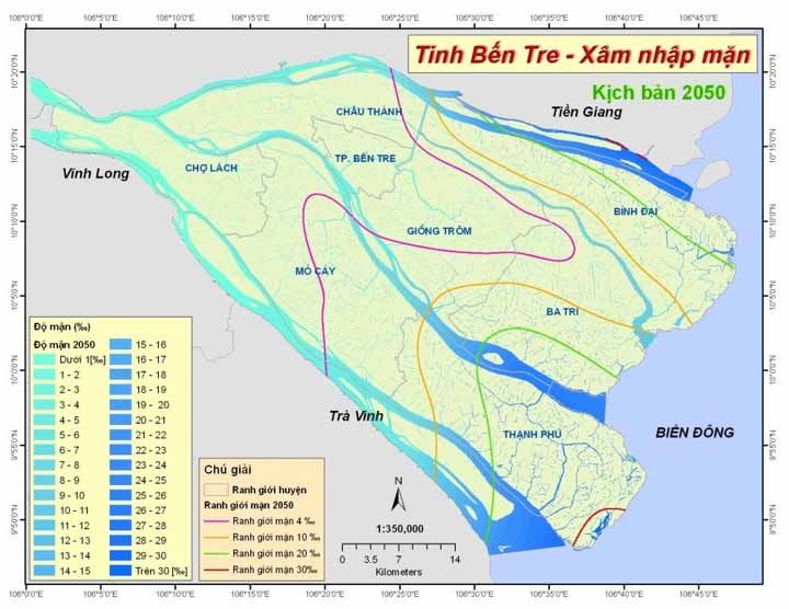
List of maps
                												Page

                Map 1. Map of Ben Tre province and study areas						                                                 13
                Map 2. Inundation areas if sea level raised at 75cm by 2100, (Bentre DONRE, 2011)                    34
                Map 3. Saline intrusion projection in Ben Tre province in 2050 (Source: SIMHE, 2010)                 35
                Map 4. Current land use-land cover in Ben Tre provinces						                                        46
                Map 5. Business as Usual scenario in 2020 in Ben Tre province					                                   47
                Map 6. Rapid Development scenario in 2020 in Ben Tre province					                                   47
                Map 7. Biodiversity Conservation scenario in 2020 in Ben Tre province				                            48
                Map 8. Vulnerability index of three scenarios in comparison with the current land cover		            50
                Map 9. Land-points observation along the coastline in Ben Tre					                                   51
                Map 10. Carbon Storage 2010, generated from Current Land-Cover Map				                               53
                Map 11. Carbon Storage and Sequestration under Business as Usual Scenario in 2020		                  54
                Map 12. Carbon Storage and Sequestration under Rapid Development Scenario in 2020		                  55
                Map 13. Carbon Storage and Sequestration under Conservation Scenario in 2020		                       56
©WWF-Viet Nam

                10 | Vietnam Case Study from Field Testing an Operational Framework for Ecosystem based Adaptation
List of figures
Page
Figure 1. Process Diagram of the Process Defined by the Draft EbA Framework 15
Figure 2: Land use in Ben Tre province Viet Nam 25
Figure 3. Ranking of ecosystem services in Binh Dai, Ba Tri, and Thanh Phu districts 27
Figure 4. Historical hazards in Ben Tre (Source: WWF field data, 2013) 30
Figure 5. Change in Land-Cover under three future scenarios versus baseline:
(1) BAU, (2) Conservation, (3) Development. 49
Figure 6. Reduction of Wave Height (m) by coastal habitats at Landpoint 4 under Different Scenarios 52
Figure 7. Reduction of Wave Energy (%) by coastal habitats at Landpoints 4 under Different Scenarios 52
Figure 8. Comparison Carbon Storage in Future 2020 with Current Carbon Storage by District 57
Vietnam Case Study from Field Testing an Operational Framework for Ecosystem based Adaptation | 111. INTRODUCTION
1.1. Background for the case study
Ecosystem-based Adaptation (EbA) is the use of biodiversity and ecosystem services as a part of an overall
climate change adaptation strategy to help people adapt to the adverse effects of climate change. The rich
natural capital endowment and ecosystem services in the Greater Mekong Sub-region (GMS) have continued to
play a crucial role in supporting economic growth. Recognition of the role of ecosystem services and sustainable
management of the natural resources play a key role in addressing emerging development and climate change
adaptation challenges. Therefore, EbA has great potential to be an important part of the adaptation strategy
for the GMS. EbA is still a relatively new concept. An operational framework for EbA could assist in the
institutionalization of the concept in the region and help countries develop, implement, and mainstream EbA
as a part of their development and adaptation strategies.
To respond to the needs in the GMS countries for more knowledge and expertise on EbA, a study was carried out
in joint collaboration between the World Bank and the World Wild Fund for Nature (WWF). The long-term goal of
this study was to contribute to the adoption of EbA as a part of the overall adaptation strategy in the GMS. The
role of ecosystems in strengthening resilience against climate related hazard events is gaining recognition both
in this region and on a worldwide level. However, there are still gaps in the available knowledge and practical
application of EbA that are relevant and specific to the national and sub-national context. The project has the
following specific objectives to fulfill these gaps:
- Develop an operational framework (herein referred to as the Framework), which enables govern-
ments to understand, consider, identify, develop and implement robust EbA solutions in response to
climate change. Part of the Framework provides guidance in mainstreaming EbA solutions into plan-
ning processes.
- Field-test the developed Framework in two critical landscapes in the GMS region – a wetland/forest
catchment and a coastal area. Develop case studies and subsequently modify the framework based
on lesson learned.
- Identify the entry points for using EbA framework as a tool to support the adaptation policy and plan-
ning processes of sub-national governments in Laos and Viet Nam.
This report presents the process and results of the testing in Ben Tre province in Viet Nam. The results of
the study have been used to contribute to the generic EbA framework and very importantly to elaborate
the EbA customized framework for Viet Nam; which exists as a separate document.
Apart from helping to contextualize and improve the applicability of the framework for Viet Nam, the case study
also meets the following objectives:
- Develop capacity and increase ownership of local government agencies and other stakeholders using
EbA approaches to increase resilience of coastal communities in Ben Tre province.
- Select, based on systematic and evidence-based analysis, ecosystem based adaptation solutions
for Ben Tre province.
- Identify the entry points for the EbA framework to support better and more explicit climate change
adaptation strategies for Ben Tre province and provide evidence for EbA guidelines in Viet Nam.
This case study has subscribed to several core principles of best practice EbA (as set out in the draft
framework):
12 | Vietnam Case Study from Field Testing an Operational Framework for Ecosystem based Adaptation- Promote long-term and local innovations and solutions to improve outcomes for people and for
maintaining natural capital;
- Prioritize the application, by communities and/or other jurisdictional units, of no-regrets1 actions so as
to avoid and/or reduce the adaptation deficit2; this includes focusing on reducing non-climate stresses;
- Involve local communities in addressing governance and social and environmental justice issues;
- Reflect multi-partner, multi-sector, and multi-scale considerations and approaches;
- Build on existing NRM good practices and recognize that the climate is not static;
- Adopt adaptive management approaches;
- Integrate with and embed EbA approaches and actions within wider climate adaptation strategies; and
- Promote communication and education, sharing and exchange.
1.2. Study Area
Ben Tre is one of the 13 provinces in the Mekong Delta. The province has a 65 km coast line and its four main
rivers—Tien (83 km), Ba Lai (89 km), Ham Luong (71km) and Co Chien (82km)—have been depositing and
enriching the soil with layers of alluvium for centuries. They also carry heavy silt from the upstream Mekong
River to four estuaries—Cua Dai, Ba Lai, Ham Luong, and Co Chien. They are a great advantage to Ben Tre’s
development of water transportation, irrigation systems, marine economic development, commercial agriculture,
and trade with neighboring provinces.
This study focuses on the three coastal districts of Ben Tre: Binh Dai, Ba Tri, and Thanh Phu districts.
1
‘No-regrets’ describes adaptation options that provide benefits regardless of future climate conditions. It allows climate change adaptation
to start now with actions that reduce non-climate threats while building resilience and reducing exposure and sensitivity, otherwise known
as the adaptation deficit.
2
See Footnote 1.
Vietnam Case Study from Field Testing an Operational Framework for Ecosystem based Adaptation | 13The population in Ben Tre in 2010 decreased by 0.3 percent if compared to 2005 (1,273,184 people), while the average growth rate of Viet Nam was 1.2 percent. The decrease in population in Ben Tre is thought to be due to people migrating to bigger cities such as Ho Chi Minh, My Tho and Can Tho for living, working and running small businesses. Generally, between 2005-2010, employment within aquaculture in the whole Ben Tre province decreased from 47,570 persons in 2005 to 46,058 persons in 2010 (Ben Tre Statistic office 2011). Of Ben Tre’s population, 93.3 percent live in rural areas. However, the urban population is slowly increasing with the move from agriculture to industry and commercial business. More people move into urban areas (Ben Tre SEDP 2011). The population distribution in Ben Tre province is uneven. The coastal districts have relatively low population density with the majority of the population concentrated in Ben Tre city and the inland, freshwater districts of Chau Thanh, Cho Lach, North Mo Cay and South Mo Cay. This assessment focuses on the three coastal districts (Binh Dai, Ba Tri, and Thanh Phu district), which have a combined area of 1,194.5 ha and a population of 447,812. Ba Tri district is the smallest but most dense; therefore many of its natural resources are under pressure and/or over exploited. 14 | Vietnam Case Study from Field Testing an Operational Framework for Ecosystem based Adaptation
2. METHODOLOGY
2.1. Conceptual Framework
This case study is the result of the application of the draft EbA framework prepared prior to the field-testing.
The framework provides detailed guidance for 3 major stages and their component steps:
         - Stage 1: Assessment of vulnerability of ecosystems, ecosystem services and dependent communi-
         ties/selected sector(s).
         - Stage 2: Identification and prioritization of ecosystem based adaptation options.
         - Stage 3: Recommendations for implementation and iterative monitoring and evaluation.

The framework also provides guidelines for mainstreaming EbA.

Stages 1 and 2 were field tested to develop this case study. This case study represents a rapid vulnerability
assessment as a way of field-testing the EbA framework.

Figure 1 displays the key elements of Stages 1-2: understanding the local context, assessing communities’
vulnerability to both climate change and development impacts, and developing effective adaptation strategies.

                              Comparative Analysis of different Adaptation Options
                                         including Economic analysis

                                         Adaptation Strategies identified

               Assessment of Vulnerability and Risks                     Analysis of role of ecosystems
                 to Ecosystems and Communities                            in reducing vulnerabilities

                      Discussion with local                                       Modeling, Spatial
                    governments and experts                                          Analysis

                        Consultation with                                    Mapping of Ecosystems
                          focus groups                                         and their services

                               Figure 1. Process Diagram of the Process Defined by the Draft EbA Framework

The table below summarizes the first three steps of the framework and how they were operationalized for
field-testing.

                                                         Vietnam Case Study from Field Testing an Operational Framework for Ecosystem based Adaptation | 15
Table 1. Field-Testing the Steps of the Framework
Stages and steps in the framework Tools and Methods Revisions made and associated justifications
1. Vulnerability Analysis
1.1. Understanding the context of Secondary data collection The existing Rapid Integrated
communities, their demographic, (population demographic, Vulnerability and Adaptation to CC
socioeconomic conditions, key livelihood sources etc. Focus group Assessment in Ben Tre is an important
sources of livelihood and how it is discussions, Household survey; reference.
supported by the ecosystem services Resource mapping. Field data collection was carried out in-
line with the framework.
1.2. Understanding and mapping Field transects, expert judgment, Understanding of the ecosystems and
ecosystem and ecosystem services in consultation with stakeholders, ecosystem services came primarily from
the study area community resource mapping, existing project information, and also from
InVEST. community consultation through exercises
such as resource mapping, ecosystem
services identification. It was not possible
to use InVEST prior to the analysis.
1.3. Understanding current threats Focus group discussion, Carried out in-line with the framework.
or risks from climate change to the Participatory hazard mapping,
communities creating historical timeline.
1.4. Understanding threats from Policy review, key informant Carried out primarily through community
non-climate risks and different interviews, focus group discussions, secondary data, and policy
socio economic dynamics including discussion, household interviews, review (SEDP; CC Action Plan of Ben Tre
potential development plans to the etc. province) with additional information from
communities project documents.
1.5. Understanding threats from Secondary research, focus group Dealt with as a full matrix of interactions
current climate and non-climate risks discussion, expert judgment. between climate and non-climate risks,
to the ecosystems and ecosystem people and the ecosystems. There were
services few ecosystem services analyzed.
1.6. Creating Future Scenarios to Expert judgment, focus group Future scenarios have been developed in
identify future vulnerabilities to discussion. consultation with the local communities,
Climate and non-climate change InVEST and Marxan for spatial governments, and governmental plan.
scenario analysis, land-change InVEST and land-change modeling has
modeling. been used to run the scenarios.
1.7 Assessing exposure, sensitivity Data analysis, focus group This could not be done very properly
and adaptive capacity discussion, expert judgment. for this field-testing.A SWOT analysis of
institutions was carried out to understand
institutional adaptive capacity and support
to EbA.
1.8. Summarizing the information and Data analysis, focus group The development of different scenarios
creating vulnerability matrix discussion, expert judgment. and quantifying changes in some
ecosystem services produce findings on
vulnerability.
2. Developing adaptation Strategies
16 | Vietnam Case Study from Field Testing an Operational Framework for Ecosystem based AdaptationStages and steps in the framework Tools and Methods Revisions made and associated justifications
2.1. Identifying existing coping Focus group discussion; key Carried out in-line with the framework. This
strategies and strategies for informants’ interviews. activity was done through exercises during
adaptation community consultation as well.
2.2.Multi-criteria analysis including Participatory stakeholder This was not done due to time limitation
spatial analysis consultations, land change and priority for cost-effectiveness analysis.
modeler, InVEST, Marxan with
Zones.
2.3 Cost effectiveness analysis Research; data analysis and Carried out based on the framework.
expert judgement.
The following chapters describe the field-testing teams’ experiences when implementing the draft framework.
2.2. Methods
2.2.1 Secondary research and analysis
Before starting work in the field/site, it is important to collect the secondary data available at both national and
subnational level. Any secondary data available on scientific information on climate change, types of ecosystems
in the study area (such as forest type, information on topography, geography etc.) would be useful. Similarly
demographic and socioeconomic data of communities such as male/female ratio, major sources of livelihoods
in the area etc. can be collected beforehand.
2.2.2. Stakeholder Consultation including community representatives
Stakeholder consultation process for EbA includes identifying and engaging key people and organizations that
can either impact or are impacted by any part of EbA assessment. It is necessary to do a preliminary stakeholder
assessment to identify key stakeholders that can help in initiating the discussion about the adaptation objective.
At a subnational level it may involve:
(a) National and subnational governmental agencies, such as ministries of natural resources and their
provincial and district level offices, ministries of planning and investment and their subnational offices,
sectoral ministries such as agriculture, forestry, water, land-use and their subnational offices.
(b) Technical experts in climate change and different sectors.
(c) Non governmental agencies that are engaged in climate change and adaptation related activities
(d) Community representatives.
2.2.3. Focus Group Discussion
Focus group discussion (FGD) is one of the most commonly used participatory methods to understand concerns
and perceptions of the communities. A focus group is a small group of six to ten people led through an open
discussion by a moderator. The moderator/researcher should establish a focus group based on some shared
characteristics, so that the group is more or less homogenous, everyone feels equal and no member feels
inhibited to speak. Focus group can be formed based on gender, livelihood groups, or other similarities to
facilitate the discussion on common and individual concerns and perceptions.
Vietnam Case Study from Field Testing an Operational Framework for Ecosystem based Adaptation | 17Prepare a predetermined questionnaire to conduct a focus group discussion, but the discussion should be open- ended and semi-structured. The questionnaires should not be too long and the FGD should ideally be under two hours. To make analysis easier, the same questionnaire should be used with different focus groups where possible. Other Participatory Rural Appraisal (PRA) tools such as a seasonal calendar, historical timeline, or community mapping can also be included as a part of FGD. 2.2.4. Seasonal Calendar The purpose of generating a seasonal calendar is to identify the seasonality of the (a) weather patterns, i.e. summer months, rainy season, winter etc.; (b) the community’s livelihood activities, which are often connected to resource use and resource abundance; and (c) seasonality of hazards. Communities identify different activities (agriculture, aquaculture, seasonal migration) that occur throughout a year and the guided discussion will seek to identify how the climate change will affect overall activities and whether it will alter the seasonality of community’s livelihood activities. The discussion will also seek to understand historical changes in seasonality that the community has already experienced, and the social mechanisms that the community has employed to mitigate their effects. 2.2.5. Historic Climate Trend Analysis Understanding the history of past extreme events and a community’s reaction to these events can serve as very important information for an adaptation plan. The historical trend analysis will give insight into past climate hazards, their trends, intensity, and impacts to ecosystem services and communities. The trend analysis can be done either just through discussion or by drawing a line to mark the passage of time (10-20-30 years based on the available data). 2.2.6. Participatory mapping Participatory mapping can be done either on a piece of paper, through actual maps of the study area, or as direct inputs in digital maps depending on the context. Participatory mapping can help in EbA by identifying: (a) key ecosystems, and ecosystem services and their location in the study area; (b) climate hazards showing the locations more prone to hazards; and (c) location of populations that are most vulnerable if applicable, or populations with different livelihoods. 2.2.7. Scenario Analysis A scenario analysis is a process of analyzing possible future events by considering alternative possible outcomes or alternate future developments. For EbA and/or other adaptation planning, the scenario analysis can provide useful insight on the future risks and vulnerability to both societies and ecosystems. Scenarios are developed based on certain criteria or assumptions about the future, for example, the level of infrastructure development, with or without climate change pressures among others. These criteria can either be collectively agreed upon or taken from existing and future development plans/policies. 2.2.8. Scenario analysis involving modeling tools for future vulnerability assessment The assessment of the impact of climate change on the ecosystem services can be done through scenario analysis using tools such as InVEST, land change modeler, or hydrological models, for example. Data layers that reflect climate change scenarios (e.g. sea level rise, change in precipitation) will be used as input parameters in the models. WWF uses InVEST, mostly in large-scale assessments for valuation of ecosystem services. 18 | Vietnam Case Study from Field Testing an Operational Framework for Ecosystem based Adaptation
InVEST is designed to inform decisions about natural resource management. Decision-makers, from governments
to non-profits to corporations, often manage lands and waters for multiple uses and inevitably must evaluate
trade-offs among these uses; InVEST’s multi-service, modular design provides an effective tool for evaluating
these trade-offs.

The InVEST toolset includes models for quantifying, mapping, and valuing the benefits provided by terrestrial,
freshwater and marine systems. Specifically it includes models for:

 • Wave Energy                                                • Sediment Retention Model: Avoided Dredging and
• Coastal Vulnerability                                       Water Quality Regulation
• Coastal Protection                                          • Manage Timber Production
• Marine Fish Aquaculture                                     • Crop Pollination
• Marine Aesthetic Quality                                    • Wave Energy
• Marine Overlap Analysis Model: Fisheries and Recreation     • Coastal Vulnerability
• Marine Habitat Risk Assessment                              • Coastal Protection
• Terrestrial Biodiversity: Habitat Quality and Rarity        • Marine Fish Aquaculture
• Carbon Storage and Sequestration                            • Marine Aesthetic Quality
• Reservoir Hydropower Production                             • Marine Overlap Analysis Model: Fisheries and Recreation
• Water Purification: Nutrient Retention                      • Marine Habitat Risk Assessment
                                                              • Terrestrial Biodiversity: Habitat Quality and

                                                     Vietnam Case Study from Field Testing an Operational Framework for Ecosystem based Adaptation | 19
In this field test, only three models were used to quantify the most important services of coastal ecosystems:
Coastal Vulnerability, Coastal Protection and Erosion, and Carbon Storage and Sequestration.
2.2.9. Expert Judgment
Expert judgment is an approach for soliciting inputs from individuals with particular expertise on concepts related
to EbA. Considering the complexity involved in EbA especially with regards to uncertainties and the impact of
climate change on ecosystems, expert judgment can be used for rapid assessment and analysis of different
aspects of vulnerability and adaptation prioritization of adaptation options. Expert judgment can be used in a
variety of ways including a panel format for aggregating opinions, meetings, and workshops. It is important to
realize that specific expertise may be necessary at different phases. Expert consultation may be needed in
designing the project, deciding the data to be included, and for analyzing the data rigorously to come to scientific
and experience-based conclusions.
The experts needed may include: climate change and adaptation specialists, hydrologists, ecologists (foresters,
marine biologists, etc.), species specialist for particular species, sociologists/socio economic specialists,
economists, and others that may be identified.
2.2.10 Vulnerability Matrix
Creating a vulnerability matrix is one way of presenting the vulnerability analysis. The ultimate objective of the
user should be to understand current and future risks and impacts from climate and non-climate risks in order
to come up with effective adaptation strategies.
It is good to keep in mind that the “vulnerability of a system” is best understood by looking not only at individual
pressures and impacts but also the altered interactions within the system—in this case, interactions between
ecosystem and communities.
2.2.11. Multi-Criteria Analysis
Multi-Criteria Analysis (MCA) is a decision-making tool for complex problems where multiple criteria are involved.
Since it is important to consider many social, economic, environmental criteria in selecting the final adaptation
measure, MCA can be used to compare and make a decision on the best possible adaptation measure. The
multi criteria decision support system will help in structuring the available information in a clear and concise way
so as to support the identification of the most suitable alternative; with this approach the choices made will be
participatory, explicit, and justified. MCAcan be done with or without the use of any software/computer based
tools. In both cases, stakeholder participation is extremely important to define the criteria used in analysis.
Process:
1) Collectively agree on the main categories of effects of the adaptation strategies to be considered:
environmental, social, economic, etc.;
2) Identify the criteria/indicators to be used to measure those effects (decrease in the amount of some
ecosystem services, loss of natural habitats, decrease in agricultural areas, opportunity costs, capacity
requirements, etc.).
3) Together with stakeholders, set targets for the different indicators and assign weightage/penalty
factors: how much agriculture areas, natural forest or other habitat types, etc.?
4) Follow the previous steps for each adaptation strategy;
5) Based on targets, penalty factors and costs the outcome will be maps showing the best arrangement
of the zones identified at the minimal cost for the adaptation alternatives;
20 | Vietnam Case Study from Field Testing an Operational Framework for Ecosystem based AdaptationThe MCA can also be done qualitatively without the use of any spatial tools, if needed, by collectively deciding on
different criteria, giving weightage and ranking the adaptation strategies. This assessment is qualitative in nature
but should be informed by interviews with local experts as well as published performance of these measures
against current climate hazards. The table below provides an example of a simple multi-criteria analysis.
2.2.12. Cost Effectiveness Analysis
Cost effectiveness analysis (CEA) is an economic decision-making tool. It is used to compare two or more options
for achieving the same (or similar) outcome, the benefits of which are not easily measured in monetary terms.
A classic cost-effectiveness analysis starts by stating a specific goal, such as reducing the incidence of a disease
in a town by 50 percent in four years, presents data on the expected cost of two or more methods of achieving
this goal and then selects the least-cost alternative (World Bank 2010).
An important aspect of CEA is that the main benefits of projects and interventions are not evaluated in monetary
terms. These benefits are presented in non-monetary measures of effectiveness, such as numbers of lives
saved or years without major flooding. By comparing the ratio of costs to the measure of effectiveness, options
for interventions can be ranked. Avoiding having to estimate a monetary value for an aspect of project benefit
is a key attraction of CEA.
Vietnam Case Study from Field Testing an Operational Framework for Ecosystem based Adaptation | 213. UNDERSTANDING THE LOCAL CONTEXT 3.1. Framing and Setting the Context for Analysis 3.1.1. Setting up a social ecological system Ben Tre was chosen for the case study as it is considered to be at high-risk due to its topography and geomorphology. Since the coasts were predicted to be highly vulnerable to climate change, three coastal areas were considered for the case study. Communities in these three coastal districts depended on mangroves, estuaries, and sand dunes in the area. The site was selected based on discussion with the national stakeholder group consisting of different ministries and departments. The administrative boundary of these districts was taken as the boundary of the site area for case study. The national stakeholder-working group provided overall guidance to developing the case study. The multidisciplinary team that worked in field-testing and data analysis consisted of experts in: (i) climate change, (ii) ecosystems, (iii) social research methodology and community facilitation, and (iv) local government officials with knowledge of the study areas and proposed development plan in these areas. In addition, consultants were hired for specific analysis that included GIS-based modeling and cost-effectiveness analysis. The field- testing team, led by WWF also included experts from ISPONRE, DONRE and DARD to build in the aspect of adaptive learning. 22 | Vietnam Case Study from Field Testing an Operational Framework for Ecosystem based Adaptation
3.1.2. Geographic context

Topography: The topography of Binh Dai, Ba Tri, and Thanh Phu districts is very flat, with an average elevation
of 1-2 meters above sea level (Ben TreDARD, 2009). There are several sand dune systems that reach a
maximum of 5 meters above sea level. Ben Tre can be divided into three main types of eco-elevation classes:
            - Low-lying mangrove and alluvial flats: land elevation in these areas is less than 1 m in height and flooded
            at high tide, representing 6.7 percent of the total area;
            - Moderately higher semi-tidal flats: elevation in these areas averages 1-2 m and are only submerged
            during periods of high tide from September to November, including areas of garden land and rice land,
            accounting for 87.5 percent of the total area;
            - Dunes systems: land elevation in these areas is 2-5 m and is generally composed of sand dunes,
            accounting for 5.8 percent of the area of coastal districts.

Salinity and tides: The boundaries of saline, brackish, and freshwater areas change over time. This depends on
the tide, season, and upstream hydrology. Salinity levels within the river mouth fluctuate between 3-17 percent,
especially in the dry season. Salinity levels have a significant effect on the estuary ecosystem. Coastal areas of
Ben Tre are greatly affected by the uneven dual tides of the East Sea. The tide rises and falls twice each day
(every six hours) and has a tidal range of 2.5-3.0 m. Each month, there are two high-tide periods (the 2nd - 3rd
and 17th - 18th of the lunar calendar) and two low-tide periods (the 7th- 8th and 21st - 23rd of the lunar calendar).

Geomorphology: A large amount of alluvia is deposited into the sea from the rivers. The average suspended
substances in river water are approximately 0.3-0.8 g/liter. Due to this deposit the Mekong Delta can extend
40-60 m into the sea each year, forming islets and islands near the river mouth. However, there has also been
an increase in riverbank and coastal erosion. The coast in Ben Tre receives silt and other sediments from the
Mekong River via its tributaries. The coast’s morphological features are strongly influenced by changes within
the river and the sea from erosion and alluvial deposits due to the natural interaction of current flows.

3.1.3. Socio-Economic Context

Population: The focal districts have relatively low population densities with the majority of the population
concentrated in Ben Tre city and the inland freshwater districts.

Agriculture and aquaculture are the two primary livelihood activities of most of Ben Tre residents.

In sand dune areas, vegetable production (watermelon, white roots, bean, etc,) is the key livelihood activity. In

Table 2. Administrative characteristics of Binh Dai, Ba Tri, and Thanh Phu districts of Ben Tre province, Viet Nam

      Name of District – City           No. of town and ward/commune                   Area (km2)                Population              Density (people/km2)

                                                                                                                  132.315
Binh Dai district                      1 town and 19 communes                            410,5                                                    315
                                                                                                                (129,125)*
                                                                                                                  187.835
Ba Tri district                         1 town and 23 communes                           358,4                                                    524
                                                                                                                (190,632)*

                                                                                                                  127.662
Thanh Phu district                      1 town and 17 communes                           425,6                                                    300
                                                                                                                (129,372)*

                                                                      * Population data from 2005 (Source: Ben Tre Department of Statistics 2011)

                                                                    Vietnam Case Study from Field Testing an Operational Framework for Ecosystem based Adaptation | 23
intertidal areas, clam (Meretrix lyrata) farming and collecting provide the majority of household income. Blood
cockle (Anadata granosa) forms the main commodity farmed in mud flats.
The total salt field area in Ben Tre is 1,500 ha and is mostly (>1000 ha) situated in Binh Dai District (with 650
ha in Bao Thanh commune and 384 ha in Bao Thuan commune).
Land Use: Agriculture and aquaculture are the key livelihood activities of most of Ben Tre residents. The total
Table 3. Agricultural and fishery production in Binh Dai, Ba Tri, and Thanh Phu districts of Ben Tre province, Viet Nam.
No Product Binh Đai district Ba Tri district Thanh Phu district
1 Rice:
- Area (ha) 6,180 39,332 15,175
- Productivity (quintal/ha) 45,11 48,74 32,65
- Yield (ton) 27,879 191,687 49,550
2 Vegetable production
- Area (ha) 783 1,314 1,093
- Yield (ton) 14,045 23,824 25,183
3 Coconut
- Area (ha) 5,840 1,413 3,315
- Yield (thousand ton) 44,7 10,5 23,2
4 Cow breeding (number)
6,121 68,924 25,365
5 Pig breading (number)
14,813 19,683 17,153
6 Fishery
- Capture fisheries (ton)
54,379 53,108 7,640
- Off-shore fishing boats
649 865 18
- Aquaculture yield (ton)
46,408 13,707 12,420
- Aquaculture area (ha)
16,803 5,001 16,377
Source: Ben Tre Statistics Department, 2011
agricultural area in Ben Tre is more than 178,000 ha, which includes: 80,900 ha of rice; 5,300 ha of vegetable
products; 5,900 ha of sugar cane and 32,000 ha of water surface areas that are suitable for aquaculture (Ben
Tre DARD, 2010). In addition, there is a total area of 1,500 ha salt fields in Ben Tre of which over 1,000 ha are
in Ba Tri district.
The majority of the soil types in Ben Tre are saline soils (68-79 percent) and sandy soils (12-21percent). Saline
soils are suitable for salt and brackish aquaculture and are impossible for agriculture cultivation activities. Figure
2 shows the land use in the Ben Tre province. It can be seen that the dominant land uses are one-season clam/
shrimp farming, followed by rain-fed rice crops, mangrove forests, and sand dunes. This information is important
to note when looking at agriculture development and climate change adaptation options.
24 | Vietnam Case Study from Field Testing an Operational Framework for Ecosystem based AdaptationFigure 2: Land use in Ben Tre province Viet Nam
3.2. Recent and Historic Climate Change Patterns
Ben Tre has a tropical monsoon climate. Similar to other Mekong delta provinces, Ben Tre has two distinguishable
seasons: the wet season (early May until the end of October or early November) and the dry season.
There’s very little fluctuation of the average temperature throughout the year. The provincial temperature average
is 27°C. April and May are the hottest months of the year with average daily temperatures up to 29°C, December
is the coolest with an average temperature around 25°C. There is a large difference, however, between day
and night time temperatures: in the dry season, the difference is around 14°C and around 11°C in rainy season.
Yearly average humidity in Ben Tre is about 83 percent, with an average evaporation of 1,187 mm/year. Yearly
average rainfall ranges from 1,200-1,500 mm with an average of 110 days of rain. Ben Tre city receives higher
rainfall than the coastal areas, ranging from 1,400-1,500 mm on average. The yearly average rainfall in Binh
Dai district is 1,244 mm, 1,371.5 mm in Ba Tri district, and 1,454 mm in Thanh Phu district (CEE-CESC 2009).
Rainfall distribution is seasonally unequal with 75-95 percent of the total rain falling during the wet season, from
early May to end of Oct. August, September and October receive the highest amount of rainfall, and January,
February and March the lowest.
Ben Tre province is already experiencing climate change. Average temperature has risen by an estimated 0.05 -
0.15oC in each decade of the 20th century; between 1990 and 2005, the annual average temperatures increased
by an average of 0.3o. The trend in rainfall in Ben Tre has been inconsistent between 1990 and 2006, and can
be divided into two main phases: (1) from 1990 to 1998, average annual rainfall increased by 319.28 mm total,
for an average annual increase of 35.5 mm/year; and (2) from 1998 to 2006, average annual rainfall decreased
Vietnam Case Study from Field Testing an Operational Framework for Ecosystem based Adaptation | 25to 161.2 mm total, for an average annual decrease of 17.9 mm/year3. The period of hurricane activity affecting
the southern coast of Viet Nam is later than other areas in the country and is concentrated in November and
December. The first months of the rainy season (April-May), or even earlier (January to March) may also see
oceanic storm activity in the region. From 1961 to 2006, 12 hurricanes hit this southern coast.
In recent years, communities in the area have reported that they experience the effects of a changing climate.
There has been an increase of adverse droughts, which cause a lack of fresh water and increased saltwater
intrusion. The increase in salinity strongly impacts aquaculture activities often causing massive deaths in shrimp
and clam farms. Additionally, more unseasonable rainfall has been observed in the coastal districts that were
the focus of this study. More rain may be welcome in dry parts of the year but it can have negative impacts on
vegetable production (particularly watermelon production).
3.3. Ecosystem Services and their Importance to Local Livelihoods
The field survey, interviews with stakeholders, and reference to prior work in the study area identified four
key ecosystems and their associated livelihood dependent activities. These ecosystems and their livelihood
dependent activities are:
1. Estuarine ecosystem and captured fisheries;
2. Mangrove ecosystem and extensive/intensive shrimp farming;
3. Intertidal mudflats and sandbars ecosystem and bivalve farming; and
4. Sand dune ecosystem and vegetable plantation.
A general significance ranking of local ecosystem services was done via two different methods: (i) consultations
with representative community groups in focus group discussion, and (ii) interviews with technical officers.
Figure 3 shows the significance ranking of ecosystem services in Binh Dai, Ba Tri, and Thanh Phu districts
of Ben Tre Province as assessed via semi-structured ranking exercises conducted during consultations with
government officials and local residents.
3
Nguyen Ky Phung et al. 2010. Building action plan to respond to climate change in Ben Tre province as part of the national target.
26 | Vietnam Case Study from Field Testing an Operational Framework for Ecosystem based AdaptationFigure 3: Ranking of ecosystem services in Ba Tri, Binh Dai and Thanh Phu district of Ben Tre province.
Vietnam Case Study from Field Testing an Operational Framework for Ecosystem based Adaptation | 27Different livelihoods are dependent on a variety of overlapping ecosystems. For example, shrimp farming is
highly dependent on not only mangroves but also intertidal mudflats and the open water estuaries. Food such
as rice, fruit, fish, and fresh water to drink are the most important services that the communities use from the
ecosystems. However, habitats for wild animals are important for rice farmers and the mangrove forest is used
for protection and is important for mangrove rangers.
Table 4. Key livelihood activities and ranking of dependence on the key ecosystems
Key Livelihood Dependence level on ecosystems
activities
Open water Mangrove Intertidal mudflats and Sand dunes
estuarine sandbars
Extensive/intensive shrimp farming +++ ++++ +++ -
Clam and blood cockle farming +++ +++ ++++ -
Vegetable plantation ++ + +++ ++++
Inshore/inland capture fisheries ++++ ++ ++ -
++++ Highest level of dependence
+++ Moderate high level
++ Moderate level
+ Low level
- No dependence on ecosystem
28 | Vietnam Case Study from Field Testing an Operational Framework for Ecosystem based AdaptationVietnam Case Study from Field Testing an Operational Framework for Ecosystem based Adaptation | 29
4. RESULTS OF VULNERABILITY ANALYSIS
Prior to field activities, a literature review was conducted to assess: (i) the current institutional and policy
arrangements for climate change adaptation; (ii) the future climate trends for Ben Tre province, and (iii) the key
potential development targets in the three focal districts. The results discussed in this section are based on
both this literature review and work conducted in the field.

4.1. Current climate and development pressures to communities and ecosystems
4.1.1. Current climate pressures to communities and ecosystems

The study team conducted several stakeholders’ consultation workshops and interviews with key informants
including government departments in Ben Tre. They were used to identify threats to communities, especially
to local livelihoods from current climate and non-climate pressures.

The identification of hazards to local communities was undertaken via an approach where community
representatives assembled an historical timeline and indicated when a particular hazard impacted commodity
production or other revenue of a given community.

                       MAPPING NATURAL HAZARDS IN COASTAL DISTRICTS IN BEN TRE PROVINCE

                        1992 1994 1997 1998 2002 2006 2007 2008 2009 2010 2011 2012 2013

                                                                                                                                               Early
   Ba Tri                                    Linda                          Durian
                                                                                                                                              Storms
   Thanh Phu                                 Storm                          Storm
   Binh Dai
                                                                                                                                   High
   Ba Tri                                                                                                                          tidal
   Thanh Phu                                 High
   Binh Dai                                  tidal
                                                                                                                 Saline
   Ba Tri                                                                                                      intrusion
   Thanh Phu
   Binh Dai                                  Saline
                                           intrusion
                                                                                        Cyclone year around
   Ba Tri
                                                                           Cyclone                   Cyclone
   Thanh Phu
   Binh Dai                                                                                                                       Cyclone

                                                                                                               Drought
   Ba Tri
   Thanh Phu                               Drought

   Binh Dai

                                                                                                                                  Irrigular
   Ba Tri                                                                                                                           rains
   Thanh Phu                                                                                                         Irrigular rains
   Binh Dai                                                                                                                        Very hot
                                                                                                                                    Heavy
                                                                                                                                    rains

  Figure 4. Historical hazards in Ben Tre (Source: WWF field data, 2013)

30 | Vietnam Case Study from Field Testing an Operational Framework for Ecosystem based Adaptation
Five climate-related hazards and associated events that significantly affect the study districts are:
i) Storms/storm surges;
ii) Cyclones;
iii) Rising sea levels;
iv) Drought;
v) Irregular rainfall patterns.
Among these, storms are considered the worst events for local communities. Storms affect multiple aspects
of life at a very large scale. Communities directly on the coast are clearly the most vulnerable to storms. Two
major storms in 1997 and 2006 caused extensive damage to public infrastructure and household assets. The
most serious storm impacts occurred after storms subsided and included a lack of food and fresh water and
disease outbreak. Given damages to infrastructure, communities often had to face these challenges with limited
assistance from the government or other communities. Responses consisted of (1) temporarily moving (both
people and assets) to sturdier houses and/or inland and (2) permanent migration to other areas.
Higher spring tides and saline intrusion have also seriously impacted local communities and livelihoods. These
impacts are particularly felt during the long dry season.
The increased drought periods in the dry season are also a big concern to the coastal communities. The shortage
of freshwater for crops and other daily uses, and increased saline intrusion are significant consequences.
Aquaculture, particularly shrimp farming, is the most impacted area by increased drought periods.
Table 5. Rating the impacts of climate-related hazards to the ecosystems and its dependent livelihoods by communities
(Binh Dai/Ba Tri/Thanh Phu)
Hazards Mangroves Sand dune Intertidal Coastal sand Estuarine Brackish water Fresh water,
area dunes water ponds crop
Storm -2/-2/-1 -1/-2/0 -2/-1/0 -1/-2/0 -1/-1/0 -2/-1/-1 -/-2/-
Tornado -1/-1/-1 0/-1/-1 0/0/0 0/0/0 0/0/0 0/0/0 -/-1/-
High tide/ sea level rise -1/+2/-1 -2/-2/-2 0/-1/0 0/-1/0 -1/-2/-1 -2/-2/-2 -/-2/-
The average annual rainfall
0/0/0 -1/-2/-1 0/0/0 0/-2/0 0/0/0 -1/-1/-1 -/-2/-
is reduced
Unseasonal rain 0/0/0 -2/-1/-2 0/0/0 0/-1/0 0/0/0 -1/+1/-1 -/-1/-
Templature increase 0/-1/0 -1/-2/-1 -1/-1/-1 -1/-2/-1 0/-1/0 -1/-1/-1 -/-2/-
Drought (prolonged) -1/-1/-1 -2/-2/-2 -2/2/-2 -2/-2/-2 -1/-1/-1 -2/-1/-2 -/-2/-
Rating score:
- 2: Very serious negative impacts -1: Moderate negative impacts 0: No impacts
1: Positive impacts 2: Very positive impacts
Vietnam Case Study from Field Testing an Operational Framework for Ecosystem based Adaptation | 31You can also read