West Sale Airport Master Plan Update 2017 West Sale Airport (WSA) - July 2017
←
→
Page content transcription
If your browser does not render page correctly, please read the page content below
July 2017                   West Sale Airport Master Plan Update 2017

                            West Sale Airport (WSA)

    July 2017   West Sale Airport Master Plan Update 2017   Page 1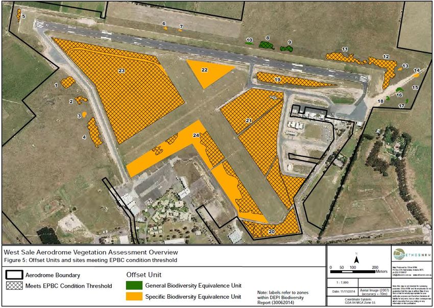
West Sale Airport Master Plan Update 2017
Wellington Shire Council

Prepared for
Wellington Shire Council
18 Desailly St, PO Box 506Sale
VIC 3850

Prepared by
To70 Aviation (Australia) Pty Ltd
Suite 14, 204-218 Dryburgh Street
North Melbourne, VIC 3051
Australia
E-mail: info@to70.com.au

In association with:
Kneebush Planning Pty Ltd
PO Box 2326, Moorabbin VIC 3189

North Melbourne, July 2017

July 2017                           West Sale Airport Master Plan Update 2017   Page 1
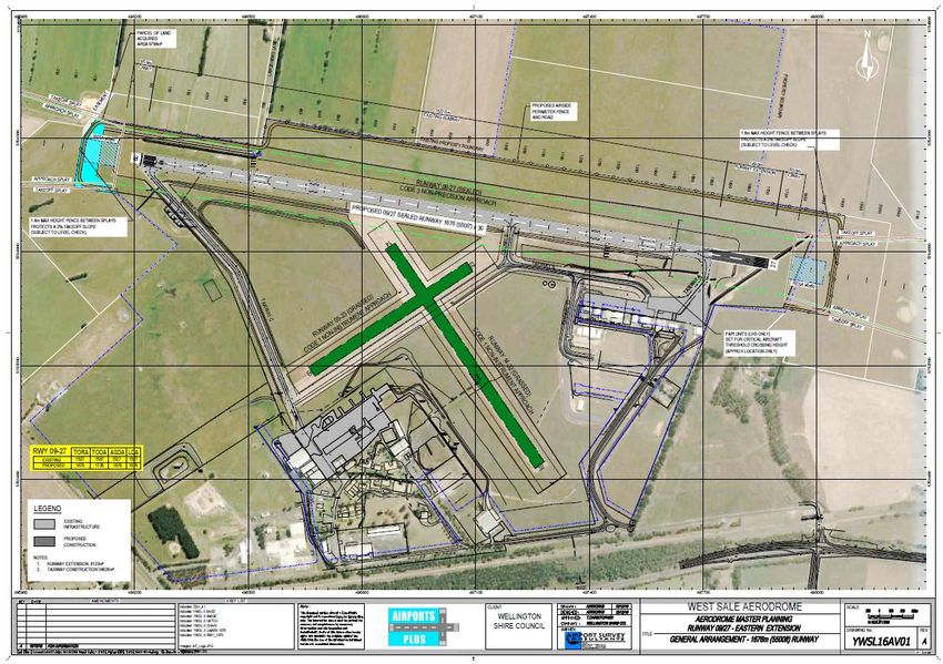
Table of Contents
1         Introduction                                                                  4
    1.1     Overview of the Airport                                                     4
    1.2     Purpose and Objectives of the Master Plan                                   5
    1.3     Methodology and Consultation                                                6
    1.4     Report Structure                                                            7
2         Background Information                                                        9
    2.1     Master Plan Context                                                         9
      2.1.1       Historical Background                                                12

      2.1.2       Regional Context                                                     12

      2.1.3       Socio-Economic Context                                               13

      2.1.4       Regulatory Context                                                   14

      2.1.5       Policy Context                                                       16

      2.1.6       Planning Controls                                                    24

      2.1.7       Key Stakeholders                                                     25

    2.2     Current Situation                                                          26
      2.2.1       Ownership and Management                                             26

      2.2.2       Site Description                                                     26

      2.2.3       Surrounding Land                                                     28

      2.2.4       Existing Activities                                                  29

      2.2.5       Existing Facilities                                                  29

      2.2.6       Ground Transport Access                                              31

      2.2.7       Utility Services                                                     31

      2.2.8       Environmental Values                                                 32

      2.2.9       Heritage Values                                                      33

    2.3     SWOT Analysis                                                              33
      2.3.1       Strengths and Advantages                                             33

      2.3.2       Weaknesses and Constraints                                           34

      2.3.3       Opportunities and Prospects                                          34

      2.3.4       Threats and Risks                                                    34

      2.3.5       Summary of SWOT Analysis                                             34

    2.4     Strategic Vision and Objectives                                            35
      2.4.1       Strategic Vision                                                     35

      2.4.2       Objectives                                                           35

    2.5     Critical Airport Planning Parameters                                       35
      2.5.1       Airspace                                                             35

July 2017                               West Sale Airport Master Plan Update 2017   Page 2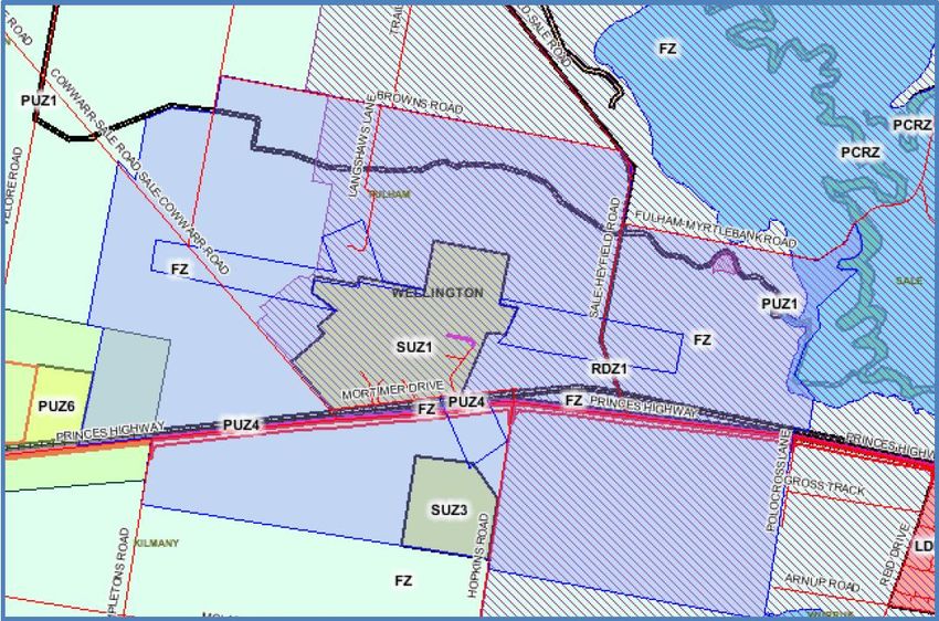
2.5.2       Forecast of Future Operations                                       36

      2.5.3       Aerodrome Reference Code System                                     38

      2.5.4       Selected Design Aircraft                                            39

      2.5.5       Navigation Systems                                                  40

      2.5.6       Aircraft Movement area                                              40

      2.5.7       Pavement Strength                                                   40

      2.5.8       Aviation Support and Landside Facilities                            41

      2.5.9       Passenger Terminal                                                  41

      2.5.10      Security Requirements                                               41

      2.5.11      Airspace Protection Surfaces                                        42

      2.5.12      Aircraft Noise Contours                                             43

      2.5.13      Environmental and Heritage Sites                                    44

3         Airport Master Plan                                                         45
    3.1     Land Use                                                                  45
      3.1.1       Land Use Precincts                                                  45

      3.1.2       Land Use Precincts Guidelines                                       46

    3.2     Facilities Development Plan                                               47
      3.2.1       Movement Area Facilities                                            47

      3.2.2       Aviation Support Facilities                                         56

      3.2.3       Other Facilities                                                    58

    3.3     Environmental Management Plan                                             58
    3.4     Airport Safeguarding Plan                                                 62
      3.4.1       National Airports Safeguarding Framework                            62

      3.4.2       Airspace Protection Surfaces                                        63

      3.4.3       Aircraft Noise Contours                                             64

      3.4.4       Planning Policies and Controls                                      65

    3.5     Implementation Plan                                                       66
Appendix A – List of stakeholders                                                     69
Appendix B – Stakeholder Feedback                                                     70
Appendix C – Wellington Shire Council Land Transactions                               76
Appendix D – 2004 DOTARS Amendment                                                    77

July 2017                              West Sale Airport Master Plan Update 2017   Page 3
1     Introduction

1.1     Overview of the Airport
West Sale Airport (WSA) is located on 200 hectares of land, 10 kilometres west of the city of Sale in Victoria
and is owned and operated by Wellington Shire Council (Council). The airport is a key economic and
community asset providing employment activities, emergency services functions, business and community
services.
Wellington Shire is the third largest municipality in Victoria covering an area of 10,924 square kilometres
with a stable population of 42,000. It has a vibrant and diverse economy with mining (primarily offshore oil
and gas) the major generator of wealth and 13.5% of jobs in agriculture and forestry, reflecting a strong
dairy sector and the increasing growth of vegetable farming. Agricultural activity is supported by a reliable
water supply, provided through the Macalister Irrigation District (MID). There is also a growing Health Care
and Social assistance sector.

Sale is located 215 kilometres East of Melbourne in Gippsland with a flying time to Melbourne of under one
hour or a two and half hour drive. It is the largest township in Wellington Shire having a direct population of
over 14,000.
RAAF Base East Sale (YMES) is located 12 kilometres to the east of WSA and is an important aviation training
facility for the Australian Defence Force.

July 2017                          West Sale Airport Master Plan Update 2017                            Page 4
Figure 1: West Sale Aerial View

1.2      Purpose and Objectives of the Master Plan
The WSA Master Plan Update 2017 is the key strategic document which underpins all activities and
decisions of Council in relation to WSA. It communicates Council’s long-term future development intentions
and projects future development opportunities.
The Master Plan Update also needs to ensure compatibility with the local community and airport users, as
well as environmental and regulatory obligations.
Council expects WSA’s future role is as a high standard facility benefiting the region through business
investment and job creation.
The West Sale Airport Master Plan has been reviewed several times since it was originally developed to
capture significant changes in the economic outlook for Sale and the wider Shire.
The latest review of the WSA Master Plan had the core objectives of providing:
•     An achievable Master Plan Update guiding the development of the Airport in the short term;
•     A strategic framework which underpins the sustainable and structured development of the Airport to
      support investment, economic growth, employment and the achievement of long-term Council
      objectives;
•     A model to ensure that the airport does not place any burden on the governance, finances and
      resources of Council; and
•     A strong linkage between future airport plans and future development and planning controls in the
      region.
This Master Plan Update identifies key strategies to ensuring future growth and development of WSA,
notably:
•     Requirements addressed in the AIR5428 Pilot System West Sale Airfield Concept of Operations and the
      actions required to meet them.
•     A new strategic vision for the Eastern Recreational Aviation Precinct (ERAP).

July 2017                          West Sale Airport Master Plan Update 2017                              Page 5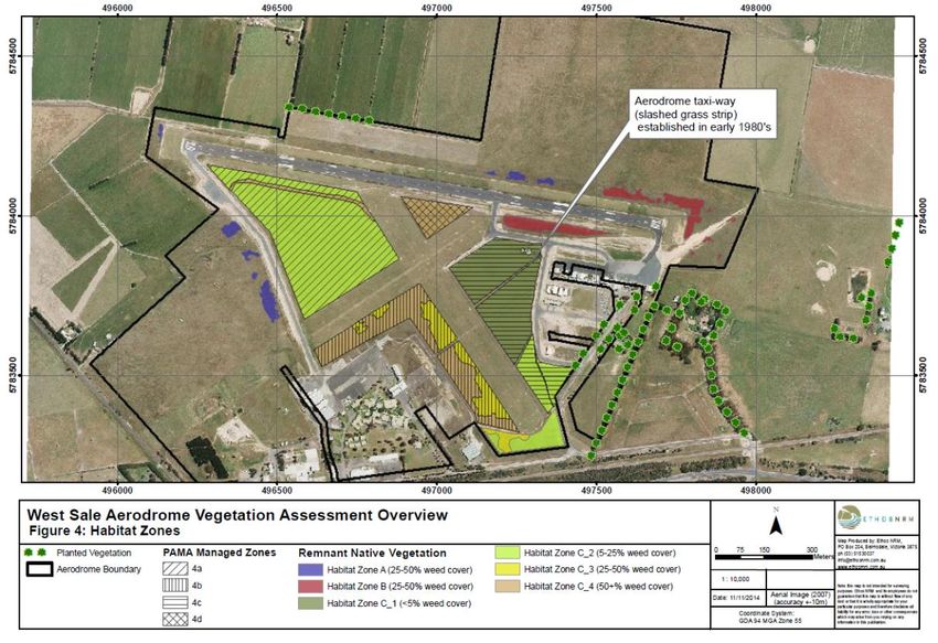
Figure 2: West Sale Airport

1.3     Methodology and Consultation
The Master Plan Update 2017 has been completed utilising internal Council resources as well as external
expertise. This approach was driven by the need to incorporate developments including the freeholding of
the Eastern Recreational Aviation Precinct and Air Force pilot training requirements (runway extension and
overlay).
Previous Master Plans and key strategic documents were reviewed and the Regional Airport Master
Planning Guideline developed by the Australian Airports Association has been used as the framework for the
Master Plan Update.
To achieve the short-term planning objectives of the Master Plan Update within the necessary timeframe
the following four stage approach has been taken.

July 2017                         West Sale Airport Master Plan Update 2017                          Page 6
Stage 1                               Stage 2
 Using previous Master Plans              Include recent strategic
 & strategic reviews, draft the          initiatives (ERAP, Air5428)
  Master Plan Update 2017                  and updated reference
  using the AAA framework                          material

            Stage 3                               Stage 4
  Master Plan Update review              ANEF development and
  and consultation process               AirServices endorsement

Figure 3: Master Plan Update Stages

As part of Council’s Community Engagement Strategy, a variety of stakeholders were consulted to identify
key issues and opportunities as part of the development of this plan. Consultation included key internal and
external stakeholders, landowners in the surrounding area, existing airport lessees and freehold owners and
other interested organisations.
In late 2015, an on-line survey was emailed to stakeholders within the WSA aviation community. They were
also encouraged to extend the invitation to other interested parties.
A summary of responses can be found at 2.1.7.
Responses following consultation regarding this Master Plan Update are shown in Appendix B – Stakeholder
Feedback.

1.4     Report Structure
This report has been structured to provide a clear description of the current situation and future
development at WSA. The Master Plan Update format is based on the Australian Airport Association (AAA)
Master Planning Guideline. The first part (chapter 1 and 2) describes current issues and it sets the scene for
the Master Plan. The second part develops the Master Plan and outlines the key elements and strategies at
WSA. The table below summarises the report structure.

July 2017                          West Sale Airport Master Plan Update 2017                            Page 7
Section                                    Description

                    Section 1 – Master Plan context           Historical background, regional, socio-
                                                              economic and policy context

                    Section 2 –Current Situation              WSA’s ownership and management;
                                                              Existing activities; Land use;
                                                              Environmental and Heritage values.

      Part 1:       Section 3 – SWOT Analysis                 Internal strengths and weaknesses;
   Background                                                 External opportunities and threats
   Information
                    Section 4 – Strategic Vision and          Future direction for WSA
                    Objectives

                    Section 5 – Critical Airport Planning     Forecast of future operations;
                    Parameters                                Aerodrome Reference Code;
                                                              Selected Design Aircraft

                    Section 1 – Land Use Plan                 Land use precincts;
                                                              Land use precinct guidelines

                    Section 2 – Facilities Development Plan   Movement area;
                                                              Aviation support facilities

  Part 2: Airport   Section 3 – Environmental Management      Previous site analysis;
   Master Plan      Plan                                      Future environmental strategy

                    Section 4 – Airport Safeguarding Plan     Commonwealth, State and Local
                                                              safeguarding plan

                    Section 5 – Implementation Plan           Trigger points;
                                                              Estimated timings

Table 1: Report Structure

July 2017                        West Sale Airport Master Plan Update 2017                         Page 8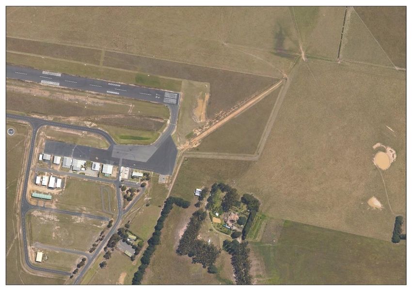
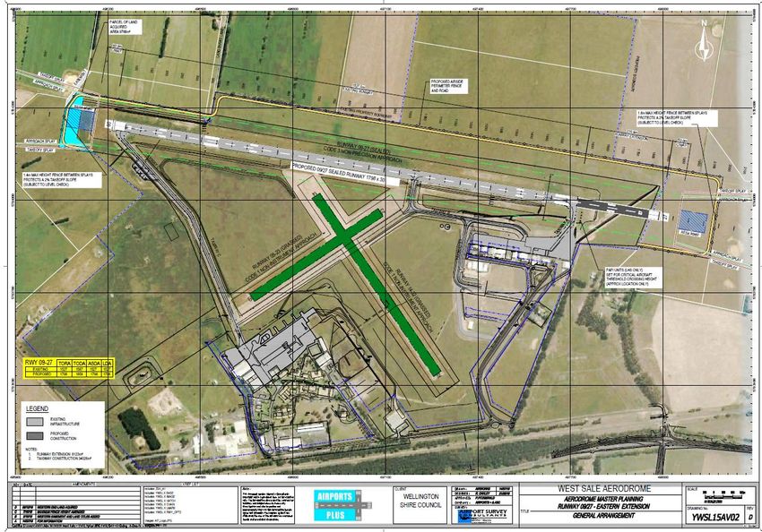
2     Background Information

2.1     Master Plan Context
Council is the owner and responsible authority for the operation and management of WSA. The Airport is a
mix of aviation industry, training and recreational aviation. Tracking of aircraft movement data commenced
in early 2016. The ongoing capture of this data will be essential in obtaining a better understanding as to
what the airport provides as well as several other issues.
The original Master Plan was developed in 1987. In 1995, a full review was undertaken after significant
changes at the airport including change of ownership and council amalgamation.
There have been two subsequent reviews and updates undertaken in 2003 and 2011. At the time of the
2011 review the plan was for a 3-5-year time horizon due to a number of uncertainties that would directly
impact the direction and investment in the airport. Some of these issues remain outstanding, whilst others
have only recently been given some clarity.
There are three recent decisions which have a significant impact on the review of the current Master Plan
Update:

West Sale Airport, Eastern (Recreational Aviation) Precinct (ERAP)
In February 2014 Council resolved to progress a 39-lot freehold subdivision within the WSA Eastern Precinct
for recreational aviation purposes.
This followed the commissioning and consideration of several reports including:
•     Initial Freehold Development Concept plan – The Airport Group (2013).
•     Report on Land Tenure – The Airport Group (Oct 2013).
•     Vegetation Overview and Habitat Hectares Assessment – Ethos NRM (November 2014).
•     Review of Wastewater Treatment and Disposal Options – The SMEC Group (March 2015).
•     Valuation report – WSA Eastern Precinct - Valuer-General Victoria (January 2015).
•     WSA ERAP Staged Planning Permit (2016)
A resolution in May 2015 directed council officers to complete the required planning permit and statutory
processes for land to be sold to existing lessees within the ERAP. Other sites will then be sold as part of a
staged release.
Note whilst the airport was transferred to Council under the federal government Aerodrome Local
Ownership Plan (ALOP) under a deed arrangement which restricted certain dealings with the land, Council
was granted permission to enter negotiations for the sale and lease of Airport land from the Department of

July 2017                          West Sale Airport Master Plan Update 2017                              Page 9
Transport and Regional Services on 13 January 2004 – see Appendix D

Figure 4: ERAP at WSA

Defence Project AIR 5428 – Basic Flying Training System (BFTS) RAAF Base East Sale
On 6 September 2015, the Federal Government announced that RAAF Base East Sale will host the Basic
Flying Training School (BFTS) for the Airforce, Army and Navy from 2019 for 25 years. This will see Pilatus
PC-21 aircraft being based at East Sale and an annual intake of up to 165 trainee pilots per year.
The impacts on WSA as an auxiliary airport have been outlined in a brief provided by defence regarding the
BFTS concept of operations. This confirms that WSA will be used by the PC-21 and by early 2020 RAAF
expects a significant flight rate increase. Specifically, WSA will be used for circuit flying training, such as
targeted training, emergency landing training, and instrument approach procedures training flight profiles.
To accommodate the PC-21, improvements to WSA will be required, notably an extension to and resurfacing
of the main runway. The Victorian State Government has committed $5.0M to ensure the essential
infrastructure required at WSA is delivered.
For Wellington, the basic flight training school means:
•    More than 500 new jobs which could add up to $28M per annum to our local economy in wages and
     salaries (combining defence and indirect flow on employment).
•    Construction and development at the RAAF Base East Sale, which will generate local demand for goods
     and services.
•    Employment for local contractors through the project’s construction phase.
•    On base personnel will increase from around 620 to over 900.
•    Population growth as increased base personnel bring their families.
•    An economic output boost of around $168M per year.
In addition to the likelihood of aviation related activity in the region increasing, there is also the potential
for other international flight training facilities to relocate to the region (Singapore, Malaysia, Papua New
Guinea).

July 2017                            West Sale Airport Master Plan Update 2017                              Page 10
Figure 5: Pilatus PC-21
Federation Training Relocation
The main campus for Federation Training in Sale is based at the Airport. From this site, occupied since 1991,
they offer a range of courses and apprenticeship training.
The location and facilities, a mix of old portable buildings and unused onsite student accommodation, are
not considered adequate to meet the expectations of a modern education facility providing a broad range of
courses. The limitations of the site have been recognised for some time and in 2010 a new site was
purchased in the Port of Sale Precinct with the intent of relocation. Federation Training are continuing to
work with Council to explore alternative options for improving education delivery in the Shire.
The medium-term future of Federation Training at the Airport, following the most recent announcements,
remains unclear. The relocation of Federation Training, even partial, would free up land with direct airside
access to the western apron area.
This Master Plan Update 2017 concerns a short-term planning horizon, considered appropriate to address
immediate planning concerns stemming from recent announcements. Other longer term possibilities will be
addressed in a subsequent Master Plan that Council expects will sustain development at the airport until
2050.
The Master Plan Update 2017 recommends practical strategies that can be implemented resulting in
incremental, but important improvements. It also sets out the triggers for implementation ensuring
demands for growth are achievable in a planned and strategic manner.
The key strategies recommended in the plan are:
• Review airport management structure to accommodate the delivery of strategies.
• Continue to monitor and identify any operational, maintenance and capital requirements noting
opportunities arising from AIR 5428 activities or any other changes.
• Undertake a comprehensive review of the zoning and planning scheme applicable to the airport
precinct and adjacent land to ensure controls are current and allow unconstrained aviation related
development.
• Continue to plan for, identify and participate in grant funding opportunities to assist with financing
identified infrastructure requirements.
• Complete capital renewal works using a staged approach that will consistently enable airport objectives
to be satisfied.
July 2017 West Sale Airport Master Plan Update 2017 Page 11• Encourage development activity within the ERAP by promoting freehold land for new hangars for
recreational aircraft.
• Evaluate requirements for other aeronautical related industries operating from WSA.
• Undertake a review of the branding and identity of the Airport.
2.1.1 Historical Background
WSA has a long and interesting history. Key points of note include:
• During World War II (1941 to 1945) it was requisitioned by the Air Force and was known as RAAF Base
West Sale / RAAF Station West Sale. During this time, it was home to a bombing and gunnery school
focused on training and coastal defence purposes. One original Bellman Hangar from the period
remains on site.
• Some years later it became the home of the National Safety Council of Australia (NSCA) Victorian
Division. The NSCA was the key tenant on the site until It’s sudden and unexpected financial collapse in
1989 and a significant amount of infrastructure from that period remains and is currently occupied by
Federation Training.
• Council assumed ownership and operational management of the Airport from the Federal Government
on 9 July 1992.
• Significant infrastructure upgrades occurred in 2012-13 as Council completed works following receipt
of a $3.0 million grant from Regional Development Victoria (RDV) in 2011, aimed at supporting a
Defence Department contract tender initiative for the interim Basic Flying Training System. This
included taxiway works, pavement rehabilitation, enlargement of the eastern apron, airport lighting
and fuel handling facilities.
• The Gippsland Armed Forces Museum (GAFM) relocated to WSA in 2009.
Figure 6: West Sale Airport entrance
2.1.2 Regional Context
Wellington Shire is defined by a hinterland to its north and a coastal strip to the south which forms part of
the Ninety Mile Beach. Latrobe Regional Airport (LRA) is a nearby provider of airport and aviation services.
July 2017 West Sale Airport Master Plan Update 2017 Page 12It is located between Morwell and Traralgon, 60 kilometres west of WSA. It is owned by Latrobe City Council
(LCC) and operates under the management of the Latrobe Regional Airport Board. Latrobe City Council is a
major regional city servicing over 70,000 people in its catchment area which includes the towns of Moe,
Morwell Traralgon and Churchill. Of similar land size as WSA, LRA comprises two runways and associated
taxiways and apron, terminal buildings and other support structures. LRA has a range of tenants including
Mahindra Aerospace, Emergency Services, an Aero Club, Department of Sustainability and Environment (Vic
Government), flying training, private hangars and commercial operators. It is within close proximity to the
Australian Paper Mill, Gippsland Water storage facility and power station coal mines. It is also surrounded
by expanding rural living developments, pine plantations, Latrobe Regional Hospital and retirement villages.
Bairnsdale Airport is another small regional airport that lies 70 kilometres to the east of WSA and is located
in the East Gippsland Shire. East Gippsland is known for its world class tourist attractions and wilderness
areas. The Airports facilities support a number of commercial enterprises including aerial firefighting,
corporate charters, aircraft support services, medical transport and a courier service.
Figure 7: Council Snapshot
2.1.3 Socio-Economic Context
Sale is the largest town in the Shire with a population of over 14,000 people (2011 Census). The top 5
employment industries and occupations are:
Employment Sectors Occupations
Agriculture 13.5% Managers 19.4%
Health care 12.8% Professionals 16.7%
Retail trade 11.8% Technicians and Trade workers 14.9%
Public administration and safety 9.7% Clerical and Administrative workers 11.6%
Education 9.1% Community and Personal Services workers 10.8%
Table 2: Sale Employment Sector and Occupation Statistics
July 2017 West Sale Airport Master Plan Update 2017 Page 13The Basic Flying Training Schools relocation to RAAF Base East Sale from 2019, as described in Section 2.1, is
expected to boost local economic output and drive jobs growth.
There are other large commercial and industrial projects at various stages of development and
implementation in the region which support future growth and liveability:
• $14.5M Port of Sale Cultural Hub Precinct Redevelopment.
• $7.6M to develop the new Sale Specialist School (Greenfield site).
• Construction of a new $1B Gas Conditioning Plant at Longford by ExxonMobil.
• $400M commitment by Esso Australia to replace the 187-kilometre pipeline from Longford to Hastings
(subject to regulatory approval).
• $185M RAAF Base East Sale redevelopment works completed. Further $209M underway due for
completion 2018.
• $260M Princes Highway East duplication - Traralgon to Sale – 9 sections estimated for completion mid-
2019.
• A $3.3 M refurbishment of the Gippsland Regional Livestock Exchange (GRLE) was completed in 2016.
WSA is adjacent to the Melbourne-Bairnsdale railway line and Princes Highway directly to its south.
The Airport has not been impacted by residential development. It is primarily surrounded by agricultural
land with Fulham Correctional Facility and the Municipal Pound being located 500 metres to the south of
the site.
The Princes Highway between the western outskirts of Sale to the junction of the Airport is currently being
duplicated. There is also a push to secure funding to fully duplicate the highway between Traralgon and
Sale.
The Gippsland Aviation Industries Policies and Opportunities Paper (WSA and Latrobe Regional Airport), The
Airport Group (2014) estimated that WSA contributes $11.8M in output and supports approximately
$12.4M in gross value-added activity. This translates to the employment of roughly 90 FTE of which one
third are directly employed.
2.1.4 Regulatory Context
Civil Aviation Safety Authority (CASA)
CASA is the authority responsible for the implementation and enforcement of safety regulations for civil
aviation operations in Australia. Their authority is derived under the Civil Aviation Act 1988 and
promulgated through Civil Aviation Regulations 1988 (CARs). CASA has powers to protect operational
airspace or to curtail aircraft operations if they believe safety is compromised.
CARs are gradually being replaced by the Civil Aviation Safety Regulations 1988 (CASRs). CASR Part 139
prescribes the requirements for aerodromes used in air transport operations.
The Manual of Standards (MOS) Part 139 Aerodromes is made pursuant to CASR Part 139 and sets out the
detailed standards and operating procedures for aerodromes used in air transport. The manual provides the
rules, mandatory standards, procedures and guidance information relating to the planning, design and
operation of Airports.
CASA conducts periodic inspections (surveillances) to ensure airport and aircraft operators meet their
responsibilities under MOS 139. Aspects of aerodrome safety relevant to WSA include;
• Aerodrome operation and maintenance
• Protection and use of runways, taxiways, and other movement areas
July 2017 West Sale Airport Master Plan Update 2017 Page 14• Protection of airfield airspace • Hazard and wildlife control • Administration The MOS139 is currently under review to ensure that it aligns with current regulatory policy (including ICAO), industry developments and technology changes. Airservices Australia (Airservices) Airservices has responsibility for the management of airspace and air traffic, and to provide Australia’s network of aviation facilities used in aircraft navigations, communication and surveillance. Local governments are encouraged to seek advice from Airservices on any development that has the potential to impact an aviation facility’s sensitive areas such as landing and navigational areas. In 2018, Australia will commence using air traffic control services with an advanced and integrated air traffic control called OneSKY. This will replace the aging The Australian Advanced Air Traffic System (TAAATS) system built and implemented in the 1990’s. OneSKY will integrate both the Department of Defence, and civilian Air Traffic Control management and systems into one system. This will realise cost efficiencies and improve safety, with the ability to cater for future air traffic growth. The implementation of the OneSKY system will increase information availability for air traffic controllers, and help minimise noise and travelling delays for the public. Military Base and Airspace Management RAAF Base East Sale is located 12 kilometres east of WSA, an aviation training facility of increasing importance for the Australian Defence Force. Controlled airspace extends to 50 nautical miles and the RAAF Base has responsibility for Air Traffic Control services to the immediate flying area, including WSA. Control is transferred to Melbourne International Airport when the centre is not manned. At times, military aircraft movements have priority over civil aircraft activities. They can also activate designated Restricted Airspace(RA1) which requires aircraft to have a clearance to enter the airspace that will not unreasonably be with-held. Environment Protection and Biodiversity Conservation Act 1999 (Commonwealth) (EBPC Act) The EBPC Act provides a legal framework to protect and manage nationally and internationally significant flora, fauna ecological communities and heritage places. The Airport contains large areas of significant remnant native grassland. A 2014 study identified 6 Plains Grassy Woodland Habitat zones which contained 84 terrestrial flora species including 49 native and 35 weed species. Notably, the area contains a rare flora species called the Rough-grain Love Grass and the critically endangered Central Gippsland Plains Grassland (also known as the Gippsland Red Gum Grassy Woodland and Associated Native Grass Land). The site is described as a key site in both the Flora and Fauna Guarantee Act 1988 (FFG Act) and EPBC Act as requiring controlled management to ensure conservation of the endangered ecological community. Any proposed development requires consideration of the impacts on the grasslands. July 2017 West Sale Airport Master Plan Update 2017 Page 15
Environment Protection Act 1970 (Victoria)
Wastewater treatment and disposal at the Airport is managed onsite.
The CFA has its own system and the other allotments have onsite septic tanks and discharge effluent is
pumped to an onsite evaporation pond.
Whilst the evaporation pond is not currently required to be licensed, if an upgrade is required due to
significant volume increases a works approval or licence will be required from the Environmental Protection
Authority.

Local Government Act 1989 (Victoria)
As a Council, owned asset, the Airport is subject to the requirements of the Local Government Act 1989.
This applies to the sale, lease, transfer exchange and use of land. Council must operate in accordance with
the Local Government Act.

2.1.5       Policy Context

National Airports Safeguarding Framework (NASF)
The NASF is a national land use planning framework that aims to:
•   Improve community amenity by minimising aircraft noise-sensitive developments near airports; and
•   Improve safety outcomes by ensuring aviation safety requirements are recognised in land use planning
    decisions.
NASF developed by the National Airports Safeguarding Advisory Group (NASAG), comprising of
Commonwealth, State and Territory Government planning and transport officials, the Australian
Government Department of Defence, the Civil Aviation Safety Authority, Airservices Australia and the
Australian Local Government Association.
NASF was agreed to by Commonwealth, State and Territory Ministers at the Standing Council on Transport
and Infrastructure (SCOTI) meeting on 18 May 2012. The agreement represents a collective commitment
from Governments to ensure that an appropriate balance is maintained between the social, economic and
environmental needs of the community and the effective use of airport sites. The Framework applies at all
airports in Australia and affects planning and development around airports, including development activity
that might penetrate operational airspace and/or affect navigational procedures for aircraft. Pursuant to
the SCOTI agreement, it is the responsibility of each jurisdiction to implement the Framework into their
respective planning systems.
NASF is comprised of a set of seven principles and seven guidelines. The NASF principles are:
•   Principle 1: The safety, efficiency and operational integrity of airports should be protected by all
    governments, recognising their economic, defence and social significance
•   Principle 2: Airports, governments and local communities should share responsibility to ensure that
    airport planning is integrated with local and regional planning
•   Principle 3: Governments at all levels should align land use planning and building requirements in the
    vicinity of airports
•   Principle 4: Land use planning processes should balance and protect both airport/aviation operations
    and community safety and amenity expectations
•   Principle 5: Governments will protect operational airspace around airports in the interests of both
    aviation and community safety

July 2017                         West Sale Airport Master Plan Update 2017                            Page 16
• Principle 6: Strategic and statutory planning frameworks should address aircraft noise by applying a
comprehensive suite of noise measures
• Principle 7: Airports should work with governments to provide comprehensive and understandable
information to local communities on their operations concerning noise impacts and airspace
requirements.
The seven guidelines are:
• Guideline A: Measures for Managing Impacts of Aircraft Noise
• Guideline B: Managing the Risk of Building Generated Windshear and Turbulence at Airports
• Guideline C: Managing the Risk of Wildlife Strikes in the Vicinity of Airports
• Guideline D: Managing the Risk of Wind Turbine Farms as Physical Obstacles to Air Navigation
• Guideline E: Managing the Risk of Distractions to Pilots from Lighting in the Vicinity of Airports
• Guideline F: Managing the Risk of Intrusions into the Protected Airspace of Airports
• Guideline G: Protecting Aviation Facilities – Communication, Navigation and Surveillance (approved
Nov. 2016)
It is understood that additional guidelines relating to Public Safety Zones and helicopter operations are
proposed to be released by NASAG in the near future.
Copies of the full set of current guidelines can be found on the Department of Infrastructure and Regional
Development’s website at the following address:
www.infrastructure.gov.au/aviation/environmental/airport_safeguarding/nasf/.
State Planning Policy Framework
The State Planning Policy Framework (SPPF) aims to ensure that appropriate land use and development
policies and practices are implemented in the planning objectives in Victoria, ensuring a balance between
community benefits, in terms of environmental, social and economic aspects, and a sustainable
development.
The following SPPF policies apply to airport use and development:
Clause 18.04-2Planning for Airports
In order to reinforce and protect the economic and infrastructure value in Victoria, this clause includes the
following strategies:
• Protecting airports from incompatible land-uses.
• Ensuring that in the planning of airports, land-use decisions are integrated, appropriate land-use
buffers are in place and provision is made for associated businesses that service airports.
• Ensuring the planning of airports identifies and encourages activities that complement the role of the
airport and enables the operator to effectively develop the airport to be efficient and functional and
contributes to the aviation needs of the State.
Clause 18.04-3 Planning for airfields
This clause reinforces the role of airfields as key centres of the State’s economic and transport
infrastructure. In order to facilitate the siting and extension of airfields and restrict incompatible land use
and development in their proximity, this clause includes the following key approaches:
• Avoid the construction of new airfield in areas that could have a greater long-term value for other
purposes.
July 2017 West Sale Airport Master Plan Update 2017 Page 17• Integrate the location planning, nearby existing and potential development and the ground
transportation system within the airfield operations.
• Avoid that existing and potential development prejudice the safety or efficiency of the airfield
operations.
• Regulations take into negative effects from aircraft operations (such as aircraft noise) on the land in the
proximity of the airfields.
• Avoid that existing and potential development prejudice any future extension or development of an
airfield in accordance with an approved strategy or master plan.
Wellington Shire Council Strategic Guidance
Wellington 2030 Strategic Vision
The Wellington 2030 Strategic Vision describes what is important to our community under five theme areas
as we progress towards 2030:
Theme
• Services and Infrastructure
• Natural Environment
• Community
• Economy
• Lifelong Education and Development
Table 3: Wellington 2030 Strategic Vision
Wellington 2030 has recently been renewed through a significant public consultation process and a revised
version is expected to be adopted in 2017.
Council Lease and Land Transactions Policy
Council has adopted policy regarding Lease and Land Transactions and these have relevance to WSA. Polices
ratify Council’s interest and ability to establish leases of up to 50 years in the Eastern (Recreational Aviation)
Precinct. These policies are available from council’s website.
Wellington Planning Scheme -Municipal Strategic Statement
The Wellington Planning Scheme (WPS) is the instrument by which the current and future development of
the Shire is guided and controlled. Land use is governed by the identification of planning zones, designating
land uses as acceptable, not acceptable or requiring approval.
Overlays which identify special considerations or constraints, are provided in addition to zones and are to be
applied to any proposed development within the affected location. The land use zonings and overlays that
apply to the WSA are identified below in Figure 8 and Figure 9.
The WPS Municipal Strategic Statement (MSS) recognises that WSA delivers significant employment,
July 2017 West Sale Airport Master Plan Update 2017 Page 18transport, and economic development opportunities.
Clause 21.17-4 of the Municipal Strategic Statement states:
“Aviation related companies are based around the RAAF Base at East Sale and the West Sale Aerodrome.
The airfields are important assets and provide opportunities for the establishment of a range of aviation
related businesses and value-added industries in the region.”
To capitalise on the opportunities afforded by these aviation facilities, clause 21.17-4 includes the following
strategies:
• Support the development of aviation related industries on, or in close proximity to, aerodromes.
• Ensure that land use or development around aerodromes does not impact upon their existing and
future use
Figure 8: Special Uses zone
July 2017 West Sale Airport Master Plan Update 2017 Page 19Figure 9: West Sale Airport Environs Overlay - Schedules 1 & 2
Local Planning Policy Clause 22.05: Aerodrome and Environs Policy
This clause has been developed for the East Sale RAAF Base and West Sale Aerodrome in order to ensure
that:
• The safety and the efficiency of aerodromes operations is not prejudiced by any new use or
development of land nearby
• Any detrimental effects of aircraft operations are taken into account in planning the use or
development of and nearby
• A range of education and industry opportunities in association with aeronautical activities.
In order to satisfy these key objectives, the clause states:
• The effect of the proposal on the amenity area.
• The need to co-ordinate the planning of areas close to the aerodrome.
• The suitability of building design and external building materials.
• The height of the proposed development.
• Whether the grant of a permit would detrimentally affect the operational safety of aircraft or the
opportunity for the reasonable future expansion of the aerodrome.
• Buildings within a designated Australian Noise Exposure Forecast (ANEF) area should be considered in
accordance with the provisions of the Standards Association of Australia, AS 2021-1994.
Finally, the clause specifically addresses that applications to use or develop land within and around WSA
July 2017 West Sale Airport Master Plan Update 2017 Page 20should consider the above requirements whether:
• The site relevant to the application is located within the designated area for development as shown on
the West Sale Aerodrome Master Plan, November 2002 or any superseding document, including this
Master Plan Updates.
• The application will adversely affect the functionality of West Sale Aerodrome.
• The application will adversely impact sites specified as having significant flora and fauna values as
outlined in the West Sale Aerodrome Master Plan, November 2002 (or any superseding document,
including this Master Plan Updates) and the West Sale Aerodrome Public Authority Management
Agreement, June 2003 or any superseding document.
Aerodrome Business Plan 2000 – 2004
Whilst the West Sale Aerodrome Business Plan is long standing, there are key points that remain relevant
today.
Notably, the Business Plan identifies the need to calculate the real costs of operating the aerodrome and a
formula developed for the recovery of a fair proportion of the costs from users. Implementation of actions
relating to cost recovery from the 2000 business plan have not been implemented.
Regional Strategic Direction
2016 – 2022 Economic Development Strategy
Two of strategic objectives of the 2016-22 Economic Development Strategy are:
• Economic Diversity – Ensuring we can leverage from our existing industries and assets to diversify the
economy through value-adding activity.
• Amenity and Infrastructure – Ensuring sufficient investment in critical infrastructure to support current
activity. Attract new investment and attract and service residents.
It was recognised that Wellington’s economy is stable because of its ‘specialised diversity’ with agribusiness,
Defence, oil and gas, and public administration, which together employ around 60
% of the workforce.
The Strategy highlights Defence and Aviation as both significant local competitive strengths and with greater
industry growth potential.
An opportunity recognised by the Strategy was to leverage from major expansion of RAAF Base East Sale
from the commencement of basic flying training in 2019. Additionally, the co-location of all initial aviation
training at the Base may become an attractor to other aviation training and business opportunities.
To capitalise on this, Council can find opportunities for complementary business activity, starting with
research into the type of economic activity that can leverage from a major Defence presence. The strategy
noted that Council had already started these efforts with growth and development opportunities at West
Sale airport the subject of detailed analysis. Important partnerships had been formed to assist, with the
main enterprises and entities involved with Defence.
The 2016-18 Economic Development Strategy Action Plan has as an action to continue to investigate options
for developing aviation related activity at West Sale Airport and states that West Sale represents a
significant asset that has yet to reach its potential.
Sale, Wurruk and Longford Structure Plan
The Plan was formally adopted by Council on 7 September 2010 and was incorporated into the Wellington
July 2017 West Sale Airport Master Plan Update 2017 Page 21Planning Scheme via Planning Scheme Amendment C67 on 8 November 2012. A further update was adopted
on 16 October 2014 via Planning Scheme Amendment C89.
The Plan provides a planning tool that sets out a long-term vision for the future growth and development of
the district with the aim of improving the physical settings within which people live, work and engage in
recreation.
Of the seven themes contained in the plan, Industry and Transport and Movement are relevant to the
review of this Master Plan.
The Industrial Theme identifies three directly relevant objectives:
• IT#2 – to provide economic development and local employment opportunities in industrial activity by
ensuring that adequate zoned land is available to facilitate future industrial development in areas that
are easily accessible from major transport routes.
• IT#4 – to protect and enhance the capacity for RAAF Base East Sale and the WSA to operate and
develop as a major employment and technology base for the area.
• IT#5 – to provide for a multi modal freight exchange area for freight and logistics operators that
capitalises on strategic locations with good road, rail and air connections.
The plan identifies:
• an area to the east of the airport as current and future industrial zoned land to encourage freight and
logistics uses that are supported by the road, rail and aviation infrastructure (multi modal freight
exchange);
• an area to the immediate west of the airport for specialised light industrial uses associated with the
airport; and
• a large area (105 hectares) to the south east of the airport for future long term industrial development
which is partly affected by airspace protection constraints.
July 2017 West Sale Airport Master Plan Update 2017 Page 22Figure 10: Overall Structure Plan The Movement theme focuses on road, pedestrian and public transport. It identifies a potential road bypass route for heavy vehicles to avoid the Sale CBD (via Myrtlebank) to the east of the Airport and proposed multi modal freight exchange. The stretch of road between Sale and the Airport is currently being duplicated and a roundabout is being built at the intersection with the Sale-Heyfield Road to facilitate such a future bypass. Gippsland Regional Plan 2015-2020 The Gippsland Regional Plan 2015-2020 (GRP) is a long term strategic plan for improving economic, social and environmental outcomes for the Gippsland region and is the result of the combined vision and efforts of the six local Governments (including Wellington), Regional Development Australia, committee for Gippsland and the GRP Leadership Group also comprising on the Gippsland Regional Management Forum. Key projects and strategies identified relevant to the Airport, in addition to securing the Basic Flying Training School, include: Continuing advocacy for the development of the Port of Sale Education Precinct to improve vocational training facilities in Sale. This includes: July 2017 West Sale Airport Master Plan Update 2017 Page 23
•    Relocation of the Federation Training Facility to Sale

•    Gaining policy support for key manufacturing sectors, including aeronautical.

•    Maximising urban growth in Sale.

Gippsland Freight Strategy - June 2013

The strategy was developed to help realise the region’s opportunities and set out the actions necessary to
enable the efficient movement of a growing freight network. The strategy addresses investments in critical
infrastructure, regulatory reform, improved access to skills training and job opportunities and strategic and
community planning.

Relevant to the airport is:

•    The upgrade and duplication of the Princes Highway between Traralgon and Sale to M class standard.
     Whilst certain sections are currently funded for duplication and works are occurring, it is estimated
     that a further $100M is required to enable full duplication. The airport is directly accessed via the
     Princes Highway.

•    Developing an alternate truck route for key towns, including Sale.

•    Promoting the development of a rail-road intermodal facility at West Sale.

•    Investigating the implementation of an air freight service out of Gippsland.

•    Consider an extension of the High Productivity Freight Vehicles (HPFV) network to Sale.

2.1.6       Planning Controls
Airport Zoning
The Airport is recognised as being public land and is affected by the Special Use Zone - Schedule 1.
The purpose of the zone is to:
•    Provide for the safe and efficient operation of the WSA;
•    Provide for the development of aeronautical industries and activities;
•    Provide for educational facilities appropriate to the site; and,
•    Ensure existing and future activities on the site will not adversely impact areas specified as having
     significant flora and fauna values.
The Airport is surrounded by Farming Zone (“FZ”) land; the south boundary of the SUZ1 is bounded by the
railway line (PUZ4) and the Princess Highway (RDZ1).

Airport Environs Overlay
The Airport Environs Overlay applies to the airport site and surrounding land as shown in Figure 9.
The purposes of the Airport Environs Overlay (Schedule 1 & Schedule 2) are to:
•    Identify areas which are, or will be, subject to high levels of aircraft noise, including areas where the
     use of land for uses sensitive to aircraft noise will need to be restricted;
•    To ensure that land use and development are compatible with the operation of airports in accordance
     with the appropriate Master Plan and with safe air navigation for aircraft approaching and departing
     the airfield;
•    To assist in shielding people from the impact of aircraft noise by requiring appropriate noise
     attenuation measures in new dwellings and other noise sensitive buildings;

July 2017                           West Sale Airport Master Plan Update 2017                            Page 24
• To limit the number of people residing in the area or likely to be subject to significant levels of aircraft
noise; and buildings are to be constructed to comply with AS2021-2000 Acoustics – Aircraft Noise
Intrusion - Building Siting and Construction.
The Overlay also trigger the need for a planning permit in order to respond and comply with Clause 22.05 –
Aerodrome and Environs Policy.
AEO’s are typically based on ANEF contour boundaries, which identifies land subjected to high levels of
aircraft noise. This supports appropriate land planning controls to prevent the noise sensitive developments
in areas impacted by high levels of aircraft noise. It is important to note that the existing AEO at WSA is
currently not based on an established ANEF.
Design and Development Overlay
WSA land is also covered by the Design and Development Overlay – Schedule 6 which addresses building
and structure heights (restriction) required to protect safe operations for aircraft operating at RAAF Base
East Sale.
There is no DDO protecting the Obstacle Limitation Surfaces of West Sale Airport.
2.1.7 Key Stakeholders
An Engagement Plan was developed specifically for this Master Plan Update. The Engagement Plan outlined
the importance of seeking feedback on the Master Plan from a wide range of airport, industry and
government/agency stakeholders.
July 2017 West Sale Airport Master Plan Update 2017 Page 25Appendix A – List of stakeholders This presents a list of identified stakeholders. This included internal
stakeholders, landowners in the surrounding area, existing airport lessees and freehold owners and other
interested organisations.
Workshops were held internally and involved representatives from strategic and statutory planning,
Executive Management, Economic Development, Assets and Projects, Built Environment and Airport
Management.
In 2015, an on-line survey was emailed to identified external airport stakeholders. The questionnaire
response rate was very high. A total of 41 individuals completed the survey. A demographic summary of
those completing the questionnaire shows:
• 30% are lessees and 10% owners of land at the Airport.
• 35% had been at the Airport for over 15 years.
• 65% held some level of pilot licence.
• 40% owned or leased aircraft.
• 20-25% were unsure of the condition of the airport.
• In terms of condition, the worst aspect of the Airport was the entrance and the best the apron areas
and sealed runway.
• 90% said that an increase in flying activities would create opportunities.
• 80% said that pilot training should be an area of focus and 75% said aircraft maintenance.
• In terms of non-aviation activities, 70% said a museum and 60% said trades, could be developed or
expanded.
• 70% said that Council offering 50 year leases in the recreational precinct is a positive outcome.
• In terms of Council offering freehold land within the Eastern Recreational Aviation Precinct, 75% and
80% respectively said it would attract development and be a positive outcome.
• 60% hadn’t made contact with Council in the previous year, 35% had participated in airport meetings
and 70& were interested in receiving info regarding the outcome of any meeting.
• 60% learn about changes by word of mouth, 45% will not contact Council directly.
2.2 Current Situation
2.2.1 Ownership and Management
Council is the owner, operator and manager of WSA.
After the previous Master Plan review, a fulltime Coordinator Aerodromes has been appointed covering
both West Sale and Yarram. Since the appointment in June 2013 significant attention has been placed on
building productive relationships with landholders and lessees, resolving longstanding issues and improving
the overall amenity.
A casual Aerodrome Reporting Officer (ARO) is also engaged, on average two days a week, to provide
maintenance and support services at WSA also carrying out Works Safety Officer (WSO) duties.
2.2.2 Site Description
The primary features of the airport include:
• One sealed runway of 1527m (09/27) which runs east west;
July 2017 West Sale Airport Master Plan Update 2017 Page 26• Two grass runways of 699m (14/32) running NE/SW, and 500m (05/23) running NW/SE; and • Sealed aprons and taxiways Figure 11: WSA Aerial view Key landside areas of the airport include: • Terminal Precinct. • Eastern Apron Precinct (lots fronting eastern apron). • Eastern Recreational Aviation Precinct (area to the south of the above lots). • Western Industrial / Commercial Precinct. • Gippsland Armed Forces Museum (GAFM). • Educational and training precinct – Federation Training and Esso Training Facility. • Country Fire Authority training ground. July 2017 West Sale Airport Master Plan Update 2017 Page 27
Figure 12: Aerodrome Title Plan 2016 – subject to amendment noting Land Exchange / Runway Extension.

2.2.3       Surrounding Land

The Airport is located on a 200-hectare site and is surrounded by agricultural land. The Melbourne-
Bairnsdale railway line and Princes Highway border the southern boundary of the airport.

Fulham Correctional Facility is located approximately 500 metres to the south on Hopkins Road. This is

July 2017                         West Sale Airport Master Plan Update 2017                           Page 28
Victoria’s largest medium-security correctional centre which currently houses 845 adult male prisoners.
Plans are also underway to add an additional 54 beds bringing the total population to 940. The Municipal
Pound is located opposite the correctional facility.

2.2.4       Existing Activities

The current primary activities on the airport include:
•    Aircraft repair and maintenance
•    Flight training
•    Recreational flying
•    CFA training
•    TAFE training
•    Sea Survival Training Centre
•    Aviation Museum

2.2.5       Existing Facilities

Movement Area

As shown in Figure 13 below, the movement area comprises the following features:
•    Runway (RWY) 09/27: sealed runway; dimensions 1527m x 30m facing east-west. This is suitable for all
     general aircraft (GA) and most regional RPT and Code 3C aircraft. The flexible asphalt pavement has a
     PCN of 12 with a maximum allowable tyre pressure of 600 (87 PSI). This allows aircraft up to 21,000kg
     take-off weight to operate without restriction.
•    RWY09/27 strip; dimensions 1650m x 150m.
•    RWY14/32: grass; dimensions 699m x 30m in the NE-SW direction serving GA and training aircraft.
•    RWY14/32 Strip; dimensions 699m x 90m.
•    RWY05/23 Grass; dimensions 500m x 30m in the NW-SE direction serving GA and training aircraft
     especially in the cross winds to the main strip.
•    RWY05/23 Strip; dimensions 500m x 90m.
•    Apron; sealed; offset from eastern end of RWY09/27. This area provides charter, Air Ambulance
     movements and both fixed and rotary wing GA operations.
•    Apron; sealed; located south of RWY05/23 (RWY05 approach end).
•    Taxiway Alpha; sealed asphalt pavement 15m wide
•    Taxiway Bravo; sealed running parallel along part RWY09/27, links also to eastern apron. Code B
     taxiway which serves the GA hangars to the south of the main apron.
•    Taxiway Charlie; sealed linking western end of RWY09/27 with southern apron. Spray sealed pavement
     10.5m wide and capable of Code C aircraft operations based on weight; however, is designed Code B
     due to gradients. Also, has an adjoining pavement area for engine run-ups for up to 3 Class A aircraft.
•    Taxiway Echo; sealed running south to eastern lots.
•    Taxiway Echo 1; sealed running east off taxiway E (northern); and
•    Taxiway Echo 2; sealed running east off taxiway E (southern).

July 2017                           West Sale Airport Master Plan Update 2017                         Page 29
• Helicopter parking and operations also occur on the aprons and runways.
• Compass swing area (class 2) located in the run-up bay on Taxiway Charlie.
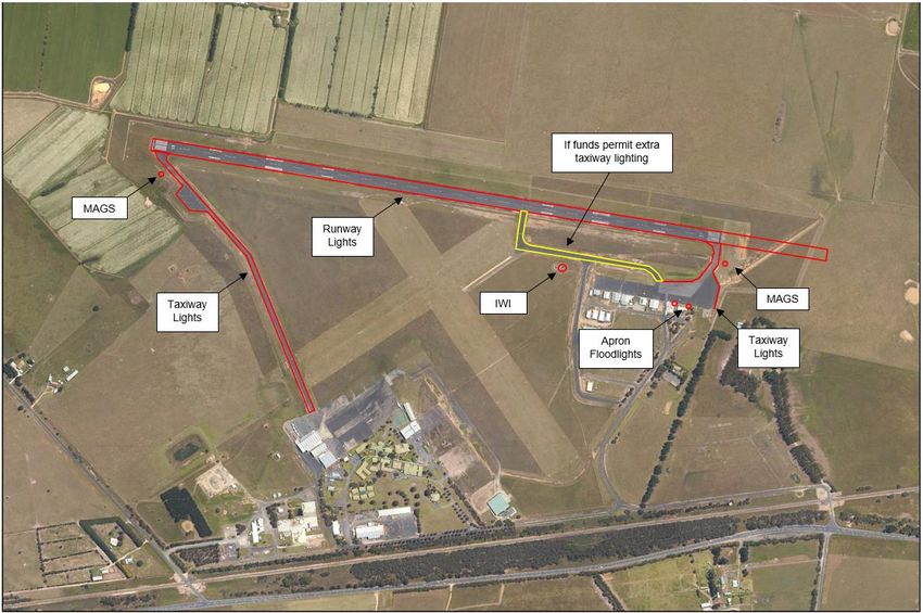
Figure 13: WSA Movement Area
Non-Movement Area
The non-movement area of the airside portion of the airport has the following features:
• Drainage line and sewerage evaporation pond under the approach to RWY05;
• Airfield lighting for RWY09/27;
• Sewer pumping facilities;
Development in these areas is limited due to a range of constraints including height restrictions to protect
operational airspace, aviation safety, environmental matters, as well as to support other operational and
management requirements.
Landside Area Infrastructure and Features
The airport layout is divided into three distinct areas. The Eastern precinct focused on general aviation and
recreational flying related activities, the Education Training precinct and the Western Precinct supporting
commercial and industrial related activity.
Eastern Precinct
The precinct contains the following facilities:
• Terminal building: The building was opened in 1983 and measures approximately 185m2. It comprises
a lounge area, booking office area, passenger counter, storeroom and baggage office and basic
amenities. Toilet facilities are accessible both internally and externally. The Airport does not currently
support RPT services and therefore is not required to support large passenger groups or the associated
processes / security requirements / management aspects. There is potential to reconfigure the space
to improve its versatility;
• Fuel facility – provides 20,000 litres storage capacity of both Jet A1 and Avgas fuel;
• Residences and office accommodation for commercial flying operations;
July 2017 West Sale Airport Master Plan Update 2017 Page 30• Access roads and car parks within terminal area; and • Utilities related infrastructure. In May 2015 Council approved and is progressing a 39-lot subdivision in the Eastern Precinct. It is intended to be a mix of freehold and leasehold properties focused on recreational aviation and a small number of associated commercial / retail opportunities. Education Training The Education precinct comprises the following facilities: • Federation Training – aviation and non-aviation related education. • Fire-fighting training facility used by Country Fire Authority (CFA). • Sea Survival Training Centre (HUET) (ESSO). Western Precinct The precinct contains the following uses: • Bellman hanger – storage. • Engine Repair workshop (privately operated). • Utilities related infrastructure. • Aircraft servicing and repair business • Armed Forces Museum 2.2.6 Ground Transport Access Access to the Airport is from the Princes Highway via an access road link and over a railway level crossing entering the Airport from the south-east corner. The approach is not ideal having to cross a railway line shortly after turning off the main road. Redevelopment of the intersection is planned as part of duplication works on the Princes Highway and discussions with VicRoads to improve the entry point are almost completed at the time of writing this document. An alternative access route at the western end of the Airport via Cowwarr-Sale Road is under consideration subject to demand. There is adequate maintained carparking provided adjacent to the terminal. There is an opportunity to improve signage to guide visitors to key facilities and businesses located at the airport. 2.2.7 Utility Services Water, electricity and telephone are all connected to the Airport. Gas is not available. Specific issues related to infrastructure are outlined in this section. Water supply Water, electricity, fibre optic (to CFA site) and telephone are all connected to the Airport. Gas is provided to the HUET Training facility and is used to heat the pool water. Specific issues related to infrastructure are outlined in this section. Water supply July 2017 West Sale Airport Master Plan Update 2017 Page 31
You can also read