Munising - Munising, Michigan

Page created by Vincent Hardy
 
CONTINUE READING
Munising - Munising, Michigan
2021 GUIDE TO THE WILD PLACES

                 Munising
              HOME OF THE PICTURED ROCKS NATIONAL LAKESHORE

4 BIG WATER
   SEE WHY THE WORLD’S SECOND
   LARGEST LAKE TRULY IS SUPERIOR

8 BIG WOODS
   EXPLORE NEARLY ONE MILLION ACRES
   OF NATIONAL FOREST OUT OUR DOOR

15 BIG WINTER
   WANT A WALLOPING WINTER? OUR
   WINTERS ARE THE STUFF OF LEGEND

   PLUS LOCAL INTEL
   WHERE TO SLEEP, EAT AND PLAY

                       Welcome to the North!
Munising - Munising, Michigan
906-387-1717   2   906-387-1717   3
Munising - Munising, Michigan
KEWADIN FULL PAGE

906-387-1717   4                       906-387-1717   5
Munising - Munising, Michigan
Welcome
                 to the home of the Pictured Rocks National Lakeshore,
       Hiawatha National Forest, and Grand Island National Recreational Area.

                                                                                                                                    WHAT’S INSIDE
      We do outdoors BIG here in Munising—all year ‘round. So, if you’re a veteran
        of our natural habitats, or if this is your first time in the north country,
     let this guide be your guide. We love Munising and we know you’ll love it, too!
                                                                                                                                         Big Water
                                                                                                                                    8    Pictured Rocks National Lakeshore
LATE SPRING, SUMMER OR FALL Take a Pictured                     LAKE SUPERIOR & BEACHES Looking to unwind on                        10   Grand Island National Recreation Area
Rocks Cruises tour to view the majestic cliffs and rock         a sandy beach or swim in the big lake? The Miners, Sand             11   Boat Tours Galore
formations along Lake Superior’s shoreline. Or be in            Point, and Au Train areas have some of the best beaches             12   Kayaking
control of your own boat and paddle along the cliff face        you’ll find. If you want to do something a little more              13   The Alger Underwater Preserve
on a guided kayak tour.                                         adventurous, fish, canoe, kayak and enjoy our various               14   Historic Lighthouses
                                                                inland lakes and rivers.                                            16   Beaches
HIGHWAY 58 is the scenic route throughout the                                                                                       17   Fishing
Pictured Rocks park and connects Munising to the                WINTER SPORTS In the winter, you can snowmobile                     18   Waterfalls
little town of Grand Marais. Miners Castle, Chapel and          hundreds of miles of our well-groomed trail system
Beaver basins, the Au Sable Light Station, and the Grand        or try out the excellent ski, snowshoe, and winter bike                  Big Woods
Sable Dunes all have access roads along this windy              trails. For thrill seekers, visit the Eben Ice Caves and the        23   Northern Forests
thoroughfare. It’s an especially beautiful route in the fall    Pictured Rocks ice curtains near Sand Point.                        24   Shorter Hikes
when bright shades of reds, yellows, and oranges adorn                                                                              26   Longer Hikes                                                 Share your photos on Instagram
the trees.                                                      HISTORY & THE ARTS During your visit, learn about                   27   Mountain Biking                                              and we just may use them in our
                                                                Munising’s arts and culture by going on a historical                28   ATV                                                          next issue! Tag us: #Munising
GRAND ISLAND Climb aboard a Glass Bottom Boat                   photography walk around downtown, checking out                      28   What About Bears
tour and see historic shipwrecks nearby. Wine and Dine          the gift shops, and visiting museums and information
on a Grand Island Lunch and Dinner Cruise. Looking for          centers.                                                                 Big Winter
something a little faster? Tour the island on a jet boat                                                                            31   Skiing & Snowshoeing & Sledding
with Riptide Ride.                                              FEAST While dining out, be sure to sample fresh Lake                32   Ice Climbing
                                                                Superior whitefish and a pasty, two delicacies of the UP.           33   Gear Rentals
FOREST TRAILS Be sure to grab a comfortable pair of                                                                                 33   Snowmobiling
shoes, as there are miles of gorgeous hiking and biking         Whatever your adventure is in Munising, we hope you
trails in the national lakeshore and forest.                    make wonderful memories to last a lifetime.                              Munising
                                                                                                                                    34   Annual Events                           The Munising Visitor Guide is a publication
WATERFALLS The Munising area has over 10 gorgeous                                                                                   35   Local Ferments
ones – most of which require a short walk or hike to
                                                                Need help with planning?                                            35   Kid-Friendly Fun
                                                                                                                                                                                 of the Munising Visitors Bureau

access. Our majestic falls range from water trickling into      Check out our website or give us a call:                            36   Arts & History                          PO Box 421 • Munising • MI 49862 • 906-387-1717 • munising.org

a stream to cascading water falling over cliffs.                munising.org | 906-387-1717                                         37   Downtown Munising Map                   Publication design by: Proof Positive Brand Design, Traverse City , Michigan
                                                                                                                                                                                 www.proofpositivedesign.com
                                                                                                                                         Day Trips                               Photographs courtesy of: Ian Plant, Ian Plant Photography; Pictured Rocks Kayaking;
                                                                                                                                    38   Day Trips From Munising                 Dobson Entertainment Inc.; Aaron Peterson; Lee Rowe, Boatnerd.com; Gina
                                                                                                                                                                                 Harmon; Scott Kusmirek; Munising Bay Trail Network; NPS.gov; Terry Pepper.com;
                                                                                                                                    41   Area Maps                               William Duckwall; Uncle Ducky Outfitters; ValleySpur.org; Pure Michigan/Travel
                                                                                                                                    43   Fall Color Drives                       Michigan; Grand Marais Chamber of Commerce.
                                                  Each of us plays a vital role in protecting our environment. It is important to
          Recreate Responsibly                    be conscious of the effects our actions may have on plants, water systems,             Services
                                                                                                                                                                                 To advertise your business, contact Jaymie Depew: jaymiedepew3@gmail.com
                                                                                                                                                                                 Munising Visitor Guide information has been solicited from area businesses.
          & Leave No Trace                        animals, and other people. Please practice the Leave No Trace principles while    44   Dining Guide
                                                                                                                                                                                 Every effort has been made to ensure accuracy. Corrections are welcomed. The
                                                                                                                                                                                 resources that are included are provided as a service to tourists and in no way
                                                  enjoying the great outdoors and remember to take out whatever you take in.        46   Lodging Guide                           constitute an endorsement or recommendation by the Bureau.

6          MUNISING.ORG                                                                                                                                                                                                              906-387-1717                      7
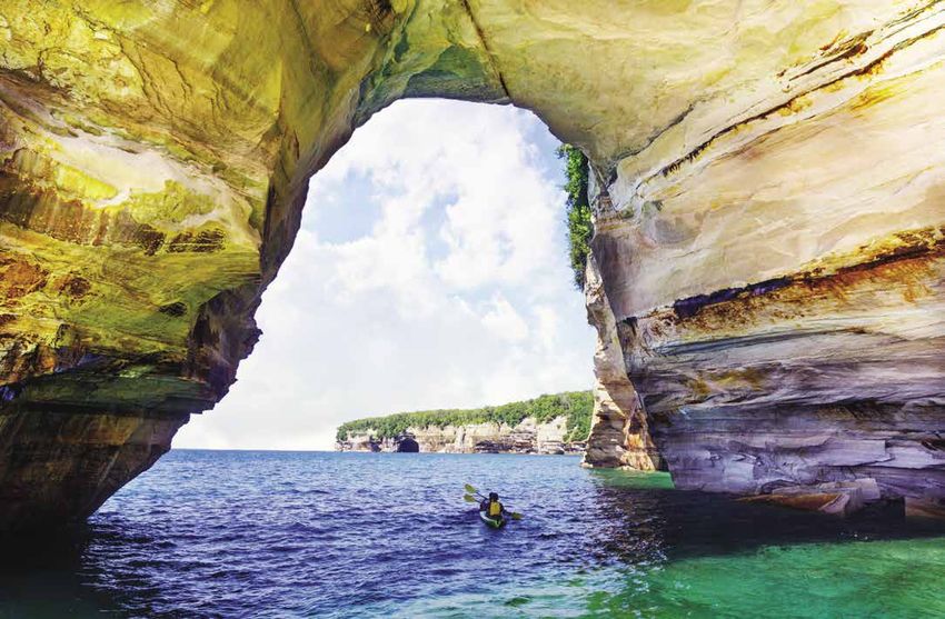
Munising - Munising, Michigan
Pictured Rocks
                                                                              national lakeshore
                                                                              four seasons TO EXPLORE
                                                                              The name “Pictured Rocks” comes from the streaks
                                                                              of dissolved minerals that stain the face of the
                                                                              water and weather-sculpted cliffs.

                                                                              An array of colors occurs when groundwater seeps through the
                                                                              cracks and trickles down the rock face. Iron (red and orange), copper
                                                                              (blue and green), manganese (brown and black), and limonite (white)
                                                                              are among the most common color-producing minerals.
                                                                                                                                                                                                      Photo: Charlie Wollborg

                                                                              Pictured Rocks National Lakeshore is managed by the National
                                                                              Park Service as one of only four National Lakeshores.
                                                                                                                                                                                  CONTACT US
                                                                              The Pictured Rocks cliffs tower 50 to 200 feet directly from
                                                                              Lake Superior and stretch for about fifteen miles along its 42-mile
                                                                              length. In addition to the cliffs, the lakeshore offers many                   The Munising Visitors Bureau - Munising.org
                                                                              beautiful beaches, enormous sand dunes, spectacular
                                                                              waterfalls, and historic lighthouses. Within the park, over 100                     The Fuzzy Boyak Welcome Center
                                                                              miles of trails lead to remote lakes, streams, and forest to explore.          129 East Munising Avenue / (906) 387-2138 /
                                                                                                                                                                      algercountychamber.com
                                                                              The park is open year-round and is truly a four-season
                                                                              recreation destination with ice climbing, cross-country skiing             Pictured Rocks National Lakeshore Visitors Centers
                                                                              and snowshoeing, snowmobiling, ice fishing, hiking, canoeing,           Munising: N8391 Sand Point Rd, Munising / (906) 387-3700
                                                                              kayaking, sightseeing, birding, boating, and camping. The list          Grand Marais: E21090 County Road H-58 / (906) 494-2660
                                                                              goes on. Words cannot fully describe the beauty of the Pictured                             NPS.GOV/PIRO
                                                                              Rocks National Lakeshore.

                    Big Water
                                                                              Pets at Pictured Rocks
                                                                              Please make sure you know the rules and where you can go with
                                                                              your pet. We want you, your pet, other visitors and our wildlife to
                                                                              all be safe.
                                                                              • Pets are not allowed in visitor centers.
                                                                              • Service animals are allowed throughout the park.
                                                                              • Emotional support/therapy animals are not service animals
         Eons of wind, water and glacial ice have influenced the geology        and may not access areas closed to pets.

      of the Munising area, carving sandstone cliffs, caves and shorelines
           of extreme beauty. The Pictured Rocks National Lakeshore
    stretches 42-mile along Lake Superior’s rugged and beautiful shoreline.
                                                                              Follow the B.A.R.K. Ranger rules:
                                                                              • Bag the poop (and discard in a garbage can).
                                                                                                                                                       Superior Knowledge:
                                                                              • Always have your pet on a leash no longer than 6 feet.                 Not only is Lake Superior the biggest of the Great Lakes,
                                                                              • Respect wildlife.                                                      but it’s also the world’s largest freshwater lake by surface
                                                                              • Know where you can go. You are responsible to know where               area. It contains 10% of all the earth’s fresh surface water.
                                                                                pets are and are not permitted.

8    MUNISING.ORG                                                                                                                                                                          906-387-1717                     9
Munising - Munising, Michigan
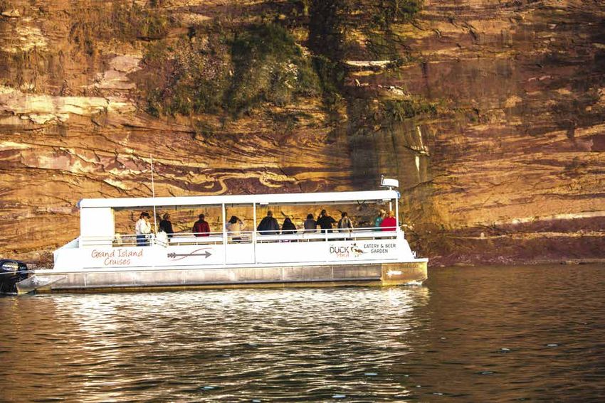
Grand Island                                                                                                                                 Boat Tours
                                                                     National                                                                                                                                     Galore
                                                                     Recreation Area                                                                                                                              Relax, Look, Learn.
                                                                                                                                                                                                                  Rich in Native American lore, shipwrecks,
                                                                     hike, bike, kayak, or take a BOAT                                                                                                            lighthouses, and dramatic beauty, learn about a
                                                                                                                                                                                                                  lifestyle that’s been shaped by Lake Superior for
                                                                     Just a half mile into the pristine waters of
                                                                                                                                                                                                                  hundreds of years aboard any of the boat tours
                                                                     Lake Superior, Grand Island was designated a
                                                                                                                                                                                                                  that operate out of Munising.
                                                                     National Recreation Area in 1990. The 13,500-acre
                                                                     island addition to the Hiawatha National Forest
                                                                                                                                                                                                                  Located across the bay from Grand Island and 10 miles
                                                                     showcases a rich natural and cultural history
                                                                                                                                                                                                                  (16.093 kilometers) from the Pictured Ricks cliffs, each boat
                                                                     and offers a unique educational and recreational                                                                                             tour offers intimate views of the area’s natural beauty and
                                                                     opportunity for all.                                                                                                                         unique geographical features.
                                                                                                                                                                                Photographer Credit

How to Get to the Island
Visitors can get to Grand Island via passenger ferry through Grand                                                                             Glass Bottom Shipwreck Tours – see ad page 3
Island Ferry Service (see below) or private watercraft. The ferry
departs from Grand Island Landing on the mainland, located on                                                                                  See real shipwrecks aboard a glass bottom boat! Located on picturesque          shipwrecktours.com
                                                                                                                                               Munising Bay, discover the shipwrecks of the Alger Underwater Preserve          1024 Commercial Street, Munising
M-28 about 2½ miles west of the Munising’s roundabout. Look for                                                                                through the clear waters of Lake Superior and view the rock formations          Phone: (906) 387-4477
the Grand Island National Recreation Area sign.                                                                                                of Grand Island. History comes alive as you hear about these turn-of-
                                                                                                                                               the-century wrecks. Open Memorial Day Weekend through September.
Getting Around the Island
Ride the Bus The Grand Island Interpretive Bus is operated                                                                                     Grand Island Cruise – see ad page 21
by the ferry service and offers a 2 ½ - 3 hour narrated bus
                                                                                                                                               Cruise around Grand Island and learn about the Native American tribes,          paddlingmichigan.com/grand-island-boat-cruise
tour on the island and runs from Memorial Day to Labor Day.
                                                                                                                                               explorers, and fur traders that once called it home. Grand Island – like the    1331 West M-28, Munising
The narrated excursion includes scenic overlooks, beautiful                                                                                    Pictured Rocks - is known for its towering sandstone cliffs, caves, and
beaches, historical buildings, and nature walks in a peaceful                                                                                  waterfalls. A complimentary meal from the Duck Pond Eatery and Beer             Depart from: Duck Pond Eatery & Beer Garden
setting. The bus trip features nine stops so you can truly                                                                                     Garden is included with the price of your ticket. You can enjoy your food       7974 M-28 West, Christmas
experience Grand Island’s beauty. Along the route, tourists                                                                                    before or after your cruise or take your meal on the cruise boat. Open          Phone: (906) 387-1695
                                                                                                                                               Memorial Day Weekend through September.
have been known to see black bear, white-tailed deer or
sandhill cranes.                                                                                                                               Lake Superior Boat Tours

Hike/Bike It The island provides a combination of rugged dirt/                                                           Photographer Credit   Lake Superior Boat Tours offers private trips for smaller groups along          lakesuperiorboattours.com
sand trails and easier gravel roads that will accommodate any                                                                                  the Pictured Rocks National Lakeshore and Grand Island. Get an up-              Phone: (906) 387-1591
level of biker or hiker. More advanced, energetic cyclists can                                                                                 close and personal tour of these impressive landmarks that you won’t
                                                                                                                                               forget. Captain Mark has over 50 years of boat experience, is DNR
mountain bike the 20-mile main island perimeter route in four
                                                                                                                                               approved and has a Master U.S. Coast Guard License.
to six hours, with time for brief stops and some exploration.
                                                                     Private Pontoon Boat Rentals                                              Pictured Rocks Cruises – see ad back cover
Short on time? Another option is to get a one-way ride for           Be the captain of your own island journey and rent a pontoon.
yourself and/or your bike to the north end of the island and hike/                                                                             Pictured Rocks Cruises offers three tours: Classic Cruise, Spray Falls          picturedrocks.com
                                                                     Full and half-day rentals available.
bike your way back. This service must be reserved in advance.                                                                                  Cruise, and Sunset Cruise. Each tour offers spectacular views of the East       100 City Park Drive, Munising
                                                                                                                                               Channel Lighthouse, Miners Castle, Lovers Leap, and other landmarks in          Phone: (906) 387-2379
Grand Island Ferry Service:                                           Seaberg Pontoon Rentals                                                  the park. The Spray Falls Cruise takes passengers a little further along the
Reservations recommended. N8016 Grand Island Landing Road,                                                                                     lakeshore to see the additional waterfall. Cruises vary from 2 to 3 hours.
                                                                       1330 Commercial Street, Munising, Phone: (906) 387-2685                 Open from mid-May through mid-October.
Munising, (906) 387-2600 / grandislandup.com
                                                                      Superior Pontoon Rentals                                                 Riptide Ride – see ad page 20
             Note: Bicycling off roads and trails is not allowed       superiorpontoonrentals.com                                              Zip around the entirety of Grand Island aboard an exciting jet boat and         riptideride.com
             because it damages fragile vegetation.                    1208 Commercial Street, Munising, Phone: (906) 387-3100                 see gigantic cliffs, waterfalls, the East Channel and Grand Island North        1309 Commercial Street, Munising
                                                                                                                                               lighthouses, and some of the Pictured Rocks. Trips run around 1 ½ hours         Phone: (906) 387-8888
                                                                                                                                               long. Open Memorial Day Weekend through mid-September.
10          MUNISING.ORG                                                                                                                                                                                                                                 906-387-1717             11
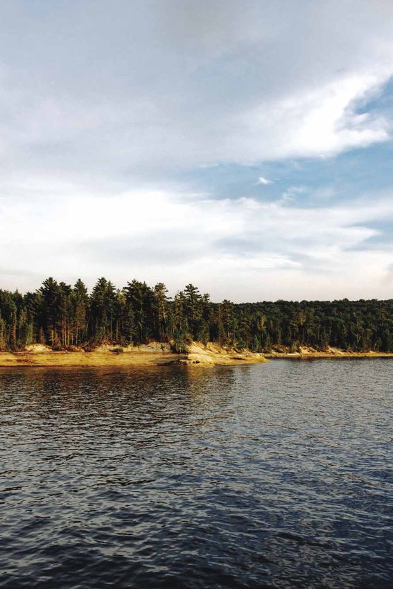
Munising - Munising, Michigan
Kayaking                                                                                                                                 the Alger
Pictured Rocks                                                                                                                           Underwater
Pictured Rocks And                                                                                                                       Preserve
The Au Train River
Since Pictured Rocks is best viewed from the water,
                                                                                                                                         Protecting What Is Left
kayaking gives paddlers intimate views of the                                                                                            The Alger Preserve is located near the dive-friendly
sandstone cliffs, sea caves and rock formations.                                                                                         city of Munising. In 1988, the Department of
                                                                                                                                         Natural Resources declared the area an underwater
                                                                   The Au Train River Canoe Pathway is a slower                          preserve and enacted laws protecting what is left
Pictured Rocks Enormous sandstone cliffs, majestic beaches
with pink sand, deep forests, sand dunes, and waterfalls make
                                                                   paced, relaxing trip where you will see and hear                      of the shipwrecks and other underwater natural
up the 42-mile-long national lakeshore of Pictured Rocks. In the
                                                                   more of the natural wilderness.                                       resources.
summer, guided kayak tours are offered every day. Lake Superior
can be as dangerous as it is beautiful. There is no shoreline
                                                                   The Au Train River offers 10 miles of excellent canoeing or           The Alger Underwater Preserve was the first preserve
                                                                   kayaking through the Hiawatha National Forest. If you are going       established in Michigan and offers several unusual attractions
along the rocks and some kayakers have found themselves in
                                                                   to fish, you will need a Michigan fishing license. Enjoy this quiet   including intact shipwrecks, sea caves and underwater
situations they had not anticipated. Because conditions on                                                                                                                                                     The Herman H. Hettler is a 235-foot wooden steamer, wrecked
                                                                   relaxing trip for the entire family without rapids or portages        interpretive trails. The sea caves are actually portions of
Lake Superior can change quickly, it’s highly recommended                                                                                                                                                      in November 1926 when she was seeking shelter in Munising
                                                                   along the river.                                                      underwater sandstone cliffs where sandstone has been
to go with an experienced guide.                                                                                                                                                                               Harbor and slammed into a reef. He is located in 30-40 foot
                                                                                                                                         eroded by waves. Kayakers can explore the many coves and              depths with outstanding visibility.
                                                                   The following outfitters offer canoe and kayak rentals for the        view shipwrecks in the crystal-clear waters of Lake Superior.
Book with one of the following kayak outfitters for an
                                                                   Au Train River:                                                       Many of the wreck sites located within the Alger Preserve are         The Kiowa, a grain-carrying 251-foot steel bulk freight steamer,
experience of a lifetime:
                                                                                                                                         protected from Superior’s temperament by Grand Island.                was hit by a gale in November 1929. She is located at a depth
     Northern Waters Adventures                                         Au Train River & Canoe Rentals                                                                                                         of 20-40 feet. On a clear day huge sections of hull are easily
     E9051 M-28                                                         N7163 Forest Lake Road                                           Shipwrecks within the Alger Underwater Preserve:                      visible from the surface.
     Munising, MI 49862                                                 Au Train, MI 49806
     Phone: (906) 387-2323                                              Phone: (906) 892-836                                             The Bermuda, a 150-foot wooden schooner that sank in the              The Manhattan, a wood-hulled freighter sank in October 1903
     Website: www.northernwaters.com                                    Website: www.exploringthenorth.com/canoe/rental.html             spring of 1870 in Murray’s Bay on Grand Island, is a very popular     and is now in 20-40 feet of water off the east shore of Grand
     Paddling Michigan                                                  Northwoods Canoe & Kayak Rentals                                 dive site for beginners to advanced divers. It lies in only 30 feet   Island.
                                                                                                                                         of water, and is protected from ice and wave damage by Grand
     331 West M-28                                                      N7070 Forest Lake Road                                           Island. The schooner sits upright with her top deck only 12 feet      The Steven M. Selvick, a 71-foot steel tug, was intentionally
     Munising, MI 49862                                                 Au Train, MI 49806                                                                                                                     sunk off Trout Point in May 1996. He is totally intact in 60 feet
                                                                                                                                         below the water’s surface.
     Phone: (906) 387-1695                                              Phone: (906) 892-8114                                                                                                                  of water and rises to within 30 feet of the surface. Captain
     Website: www.paddlingmichigan.com                                  Website: www.paddleAu Train.com
                                                                                                                                         The Smith Moore is a 260-foot three-masted steamer which              Peter Lindquist of Shipwreck Diving Tours was responsible,
     Pictured Rocks Adventures                                                                                                           sank in the Munising East Channel in July, 1889. She rests intact     in large part, for adding the Steven M. Selvick to the Alger
                                                                                                                                         in about 100 feet of water with visibility of 20-40 feet. Divers      Underwater Diving Preserve.
     Phone: (231) 420-6168
     Website: www.picturedrockskayak.com                                                                                                 with intermediate to advanced skills will enjoy this wreck.
                                                                        RULES OF THE BIG WATER:
     Pictured Rocks Kayaking

     1348 Commercial St.                                                • Wear a life preserver.                                                                                                               For more information on the Alger Underwater Preserve,
     Munising, MI 49862                                                 • If your canoe capsizes, stay with it, and hang on.                                                                                   visit MichiganPreserves.org/algerorshipwrecktours.com
     Phone: (906) 387-5500                                              • Pack your belongings in waterproof bags and tie them
     Website: www.paddlepicturedrocks.com                                 in the canoe.                                                      Superior Knowledge:
                                                                        • Spring weather in the Upper Peninsula changes quickly,
                                                                          so pack extra warm clothing even if you are planning a             The average underwater visibility of Lake Superior is 27           Glass Bottom Shipwreck Tours also offers travelers a
                                                                          short trip.                                                        feet. In places underwater visibility reaches 100 feet,            chance to peek at two shipwrecks of the Alger Underwater
                                                                        • Leave a trip plan with a friend describing your route,             making it the best in the midwest!                                 Preserve through the clear waters of Lake Superior.
                       ALWAYS
                                                                          destination, and approximate time of arrival.                                                                                         (906) 387-1695. See page 3 for ad.
       Check weather report the morning of a trip.
                                                                        • Be courteous and considerate of the area, its inhabitants,
                                                                          and other paddlers.

12         MUNISING.ORG                                                                                                                                                                                                                                906-387-1717                13
Munising - Munising, Michigan
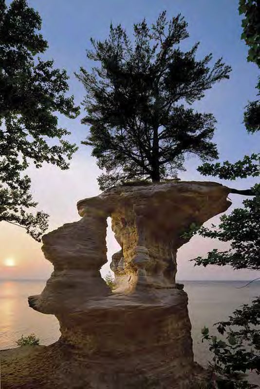
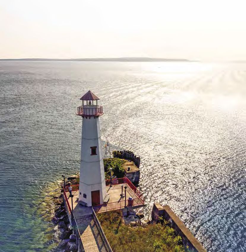
HISTORIC LIGHTHOUSES
Lifesaving Beacons
Munising and the Pictured Rocks area has seven
beautiful and historical lighthouses nestled along
the shores of Lake Superior.

Even though its only viewable by water, the East Channel Lighthouse
on Grand Island is by far the most popular. Its frame resembles
an old schoolhouse with photos of the structure adorning posters
and cards, many of which can be found at local gift shops. Though
located on private property, the lighthouse can be admired on several
boat and kayak tours in the Munising area. Enlighten yourself about
all of our local lighthouses:
                                                                                                                                 Munising Front
                                                                                                                                 XxLighthouse
                                                                                                                                  Range Light
                                                                                                                                                   Get Enlightened!
                                                                                                                                                   At 115, Michigan has more lighthouses than any other state.
                                             Munising Front Range Light

                                              Established in 1907 along with the rear light, this active light also has a continuous red           Grand Island North Light Station
                                              light. It is constructed of steel and stands 58 feet in height. The entire lighthouse is
                                              painted white. There is also a 1½-story brick building used by the park service. The
                                              site is open, but the tower is closed to the public. Located along M-28 and Hemlock
                                                                                                                                                  Grand Island East Channel Lighthouse
                                              Street in Munising.
                                                                                                                                                   The East Channel Lighthouse is one of Michigan’s most recognizable landmarks.
                                             Munising Rear Range Light
                                                                                                                                                   This wooden lighthouse dates back to 1868, when it was constructed to guide
                                              Established in 1907, the Munising Rear Range Light was placed to work in combination                 boats through the narrow channel between the mainland’s shoreline (which is
                                              with the Munising Front Range Light. The rear light was placed on the hillside at                    now the National Lakeshore) and Grand Island in Munising Bay. The lighthouse was
                                              the south end of Hemlock Street in Munising. The lighthouse is painted white and                     deactivated in 1908. In 2000, 85 volunteers worked diligently for 30 days to restore
                                              stands 33 feet in height. The site is open to the public, but the tower is closed. To                this beautiful structure. This is a privately-owned structure, with the dwelling,
                                              visit this lighthouse, take M-28 into Munising and head towards the west side of                     tower and grounds closed to the public. It is best viewed by boat or sea kayak.
                                              town (two blocks from downtown).                                                                     The lighthouse is located on the southeast shore of Grand Island.

                                             Grand Island North Lighthouse
                                                                                                                                                  Grand Island Harbor Range Lighthouses
                                              Established in 1867, the Grand Island North Light (also known as the Old North Light)
                                              is a two-story building made of brick. The Grand Island North Light stands on a 175                  Established in 1867, the Grand Island Harbor Range lights, also known as the
                                              feet cliff. This lighthouse is best viewed by boat. It is currently privately owned and              “Bay Furnace Lights,” are made up of two lights. The front light is located along
                                              was beautifully restored by the current owners. The property and lighthouse are                      the edge of the water. There is a hiking trail that leads to this light for easy viewing.
                                              closed to the public. This lighthouse is located on the north end of Grand Island.                   The rear light is 50 yards off of M-28 (on the land side). The Hiawatha National
                                                                                                                                                   Forest offers periodic free tours of the rear light during the summer months.
                                             Au Sable Point Light Station                                                                          (As it is dependent on staffing, there are no definite days and times from year to          Grand Island East Channel Lighthouse
     Munising Rear Range Light                                                                                                                     year.) For more information, contact the Munising Ranger District Center, 400 E.
                                              Established in 1874, this lighthouse is 86 feet high and delivers a strong beacon out                Munising Ave. or call 906-387-2512. Both lights are now inactive. Traveling from
                                              over Lake Superior an amazing 18 miles out. The trail is on the historic U.S. Coast                  Munising, these lights are located just east of the town of Christmas. Park by the
                                              Guard road to the light station. There are lighthouse tours in the summertime                        “Welcome to Christmas” sign.
     Superior Knowledge:                      beginning mid-June through early October. Tours are scheduled from Wednesday to
                                              Sunday. Au Sable Point Light Station is located 12 miles west of Grand Marais where
                                              you then walk from the Hurricane River Campground 1 ½ miles east. Walk the hiking
     There have been about
     350 shipwrecks recorded in
                                              trail to the east beginning at the picnic area near the Hurricane River mouth.
                                                                                                                                                   Superior Knowledge:
                                             Grand Marais Light Station
     Lake Superior. Waves of over                                                                                                                  There is enough water in Lake Superior — 3,000,000,000,000,000,
     40 feet in height have been              The Grand Marais Harbor of Refuge Inner Lighthouse was established in 1898. This
                                              is a square tower with a lantern and is painted white. It stands 55 feet in height                   or 3 quadrillion gallons to flood all of North and South America to a
     recorded on Lake Superior.                                                                                                                    depth of one foot.
                                              and is currently active. The keepers dwelling is now a museum and operated by
                                              the Grand Marais Historical Society. It is open to the public from June to September.
                                              To visit this light, take CR-702 into downtown Grand Marais, proceed northeast
                                              approximately ½ mile. The light can be seen to your right of the road before it ends
                                              at the old Grand Marais Lifesaving Station.
14            MUNISING.ORG                                                                                                                                                                                                                                    906-387-1717            15
Munising - Munising, Michigan
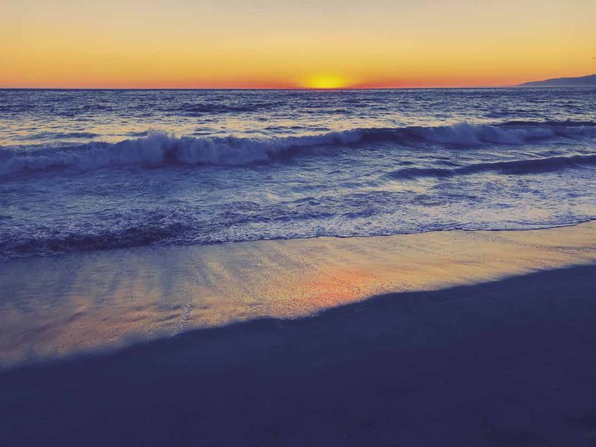
Beaches of the Lake Superior Shoreline
the guide to Getting your toes wet
The Pictured Rocks National Lakeshore has a number
of pristine beaches for you, your family, and friends
to enjoy and cherish.

Surrounded by the majestic Lake Superior, Munising has             Miners Beach
numerous swimming beaches and roadside parks to unwind
at and revel in the area’s pristine waters. Whether you dip your    Visitors are delighted with this one-mile-long picturesque
                                                                    beach. There is a wheelchair accessible boardwalk that leads
toes in a warm inland lake in the Hiawatha National Forest or
                                                                    from the parking lot to the staircase down to the beach.

                                                                                                                                                                                                                                  Superior Knowledge:
cool off on a beach in the Pictured Rocks park, you’re certain      From the top of the staircase there is a beautiful view of
to find a relaxing spot with gorgeous views. Here are some of       Lake Superior. located six miles east of Munising (on H58),
Munising’s best beaches:                                            then travel six miles north on Miners Castle Road.
                                                                    Pets are welcome but must be on a 6-foot leash.                                                                                                               The deepest point in Lake Superior is
                                                                                                                                                                                                                                  about 40 miles north of Munising
                                                                   Twelvemile Beach
                                                                                                                                                                                                                                  and is 1,300 feet (400 meters) below
                                                                    This remote beach is another great spot to linger during                                                                                                      the surface.
                                                                    a long hike. It’s also home to a 37-site campground where,
                                                                    it’s said, the stargazing at night is absolutely unparalleled.                                                                                                Lake Superior has over 400 islands,
                                                                    Located 16 miles west of Grand Marais off H-58.
                                                                                                                                                                                                                                  the largest of which is Isle Royale,
                                                                    Pets are welcome but must be on a 6-foot leash.
                                                                                                                                                                                                                                  with a size of 207 square miles.
                                                                   Chapel Beach
                                                                                                                                                                                                                                  The largest underwater formation in
                                                                    Named by early explorers as La Chapelle, Chapel Rock is a
                                                                    popular formation in the Pictured Rocks National Lakeshore                                                                                                    Lake Superior is the Superior Shoal,

                                                                                                                                       Fishing Lake Superior
                                                                    next to Chapel Beach. This scenic and sandy beach is a                                                                                                        which rises from a depth of over
                                                                    favorite stop for hikers as well as paddlers looking to stretch                                                                                               1,000 feet to within 20 feet of the
                                                                    their legs. Located approximately 15 miles east of Munising                                                                                                   water surface over a distance of just
                                                                                                                                       WHITEFISH, The big dog
                                                                    off H58 about five miles north to the end of Chapel Road.
                                                                                                                                                                                                                                  three miles.
                                                                    There’s a 3-mile hike from the parking lot to Chapel Beach.
 Photographer Credit
                                                                    Pets are not allowed.
                                                                                                                                       Trout and salmon are prized catches for fishermen on the deep blue
                                                                   Mosquito Beach                                                      waters of Lake Superior. But the local favorite is the whitefish.
                                                                    Don’t let this location’s name deter you! It’s a unique treasure
                                                                                                                                       Most Lake Superior fishing captains specialize in family fishing and you should
                                                                    when it comes to beaches, with an intriguing combination                                                                                                     MUNISING FISHERIES
                                                                    of sand, rock beds and scalloped sandstone ledges. Located         end up with a cooler full of excellent eating trout or salmon from the cool, clean
                                                                                                                                       waters of Lake Superior. Fishing areas include:                                           Located within a block from one another
                                                                    on Mosquito Falls trail, which is at the end of Chapel Road.
                                                                    A 3.9 round-trip hike is required.                                                                                                                           along Commercial Street, there are three
                                                                    Pets are not allowed.                                              Shelter Bay                                                                               fish markets offering fresh Lake Superior
                                                                                                                                       Fishing starts within 3-7 miles of the dock in Shelter Bay.                               whitefish filets, smoked fish, dip, and more.
                                                                   Sand Point Beach                                                                                                                                               - VanLandshoot Sons & Fish Market
                                                                    This gem of a beach is a popular spot for tourists and residents   Stannard Rock                                                                              - Matson’s Fisheries
                                                                    alike and is a great place to watch sunsets. Located near the      Built in 1883, the Stannard Rock lighthouse is on a reef 45 miles out from Shelter Bay.    - Brey’s Fish Market
                                                                    end of Sand Point Road, just four miles northeast of Munising.
                                                                                                                                       The reef is surrounded by deep waters, creating a natural fish hatchery. At the “Rock,”
                                                                    Pets are welcome but must be on a 6-foot leash.
 Photographer Credit                                                                                                                   fish ranging from 20-30 pounds are often caught!
                                                                                                                                                                                                                                 Fishing licenses are available at many
                                                                   Au Train Beach
                                                                                                                                                                                                                                 local businesses. A trout and salmon
                                                                                                                                       Big Reef
                                                                    During the summer months, the Au Train River warms up                                                                                                        stamp is required to fish for those species.
             Enjoy our natural beauty and                           much faster than icy Lake Superior and you will see many           The Big Reef is ideal for serious fishermen. This offshore reef near Pictured Rocks
             leave our beaches clean.                               people swimming and floating in the river. This popular            National Lakeshore is a great location to troll for trophy-sized lake trout.
                                                                                                                                                                                                                                 Persons under 17 years of age may
                                                                    roadside beach is located about eight miles west of Munising       The deepest waters of Superior are in this area. Limit catches ranging from
                                                                    at the yellow flashing light in Au Train.                                                                                                                    fish without a license.
                                                                                                                                       20-30 pounds are the norm!
                                                                    Pets are welcome but must be on a 6-foot leash.

16          MUNISING.ORG                                                                                                                                                                                                                           906-387-1717              17
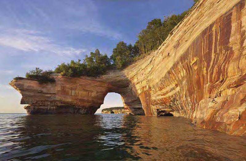
Munising - Munising, Michigan
Waterfalls
Hike | Bike | Drive
Within 15 miles of downtown Munising you can find
several waterfalls, two of them being visible from
the road. If you are hooked and want more falling
waters, stop by the Fuzzy Boyak Welcome Center
for a map of more!

The Munising area is home to 14 waterfalls—all of which are
tranquil, gorgeous places, either nestled among trees or flowing
over gigantic sandstone cliffs. Looking for something to do
while you wait to board a cruise, kayak the Pictured Rocks,
or bike around Grand Island?

                                                                                      For ice climbing ops and to see
                                                                                      frozen waterfalls see page 32.
                                                                                                                                    ROADSIDE WATERFALLS
                                                                                                                                    Please use caution while viewing these waterfalls as both are located off of busy highways.

     Munising Falls                                                                                                                 Alger Falls

     Located about a mile east of downtown, a quick trek on a paved trail up a serene            Height: 75 feet                    Alger Falls is a wonderful waterfall that cascades many small levels before reaching    Located next to M-28 a mile east
     canyon leads to a creek at the base of Munising Falls. There are two sets of stairs         Water Source: Munising Creek       the bottom. Depending on the time of year, best photos for summertime are taken         of Munising, across from M-94 junction.
     that lead to platforms for additional views of the 50-foot waterfall as it drops over       Coordinates: 46.4227, -86.6213     later in the day.                                                                       Alger Falls is viewable from the side of
     a sandstone cliff. This is perhaps the easiest waterfall to get to and is ADA accessible.                                                                                                                              the road.

     Wagner Falls                                                                                                                   Scott Falls

     Wagner Falls is about two miles east of Munising. This waterfall is stunning for those      Height: 20 feet                    The falls drops about 10 feet over a sandstone cliff into a small pool. The falls can   Located along highway M-28, this gentle
     who enjoy photographing waterfalls, or for those who would like to find a peaceful          Water Source: Wagner Creek         be seen from the highway; across the road from the H.J. Rathfoot State Roadside         waterfall is located east of Au Train and
     spot to enjoy.                                                                              Coordinates: 46.3877, -86.646      Park. Super easy access and a fun little waterfall to see and photograph.               west of Christmas. Watch for the sign,
                                                                                                                                                                                                                            park, and view.

     Miners Falls
                                                                                                                                    *All the waterfalls mentioned above are dog friendly*
     The fast-flowing Miners River drops nearly 50 feet over a sandstone outcrop,                Height: 35 feet
     creating Miners Falls – the most powerful waterfall in the Pictured Rocks park.             Water Source: Miners Creek
     The 1.2-mile round-trip hike is a popular one and great way to see some of the              Coordinates: 46.4746, -86.5315
     most treasured areas in the park due to the falls’ close proximity to Miners Beach
     and Miners Castle. This waterfall is about 10 miles from downtown Munising.
                                                                                                                                              THERE ARE OVER
                                                                                                                                           14 WATERFALLS TO BE
                                                                                                                                                                                Have more time on your hands?
     Au Train Falls                                                                                                                                                             For a list of all of the waterfalls in Munising, stop into the
                                                                                                                                          FOUND IN AND AROUND                   Fuzzy Boyak Welcome Center to pick up a complete guide.
     Au Train Falls consist of two sets of falls located on the Au Train River just south        Height: 30 feet
     of the Cleveland Cliffs basin on M-94. The falls are located approximately 15 miles         Water Source: Au Train River                     MUNISING.
                                                                                                                                                                                Find us at:
     west of Munising and require an easy 15-minute walk.                                        Coordinates: 46.33591, -86.85110
                                                                                                                                                  explore!                      129 E. Munising Avenue / (906)-387-2138 / algercountychamber.com

18             MUNISING.ORG                                                                                                                                                                                                                 906-387-1717               19
Northern Forests
                                                                                The PREsENCE is POWERFUL.
                                                                                The beauty is undeniable.
                                                                                Whether you’re into silent sports like hiking
                                                                                or biking, or perhaps you prefer to explore the
                                                                                endless acreage on an ATV or snowmobile, there
                                                                                are guidelines to keep you safe. Please refer to
                                                                                these safety tips, but know that they are the bare
                                                                                minimum. Do not hesitate to contact us with any
                                                                                questions or if you need more information.

                                                                                                                                                                                        Photographer Credit

                                                                                                                                     Safety Tips:
                                                                                                                                     Do not count on your cell phone. Many areas of Pictured Rocks
                                                                                                                                     National Lakeshore do not have cellular coverage.

                                                                                                                                     Be conservative with your trip itinerary.

                                                                                                                                     Always let someone know when you will return, whether for
                                                                                                                                     an extended backcountry trip or a day hike.

                                                                                                                                     Biting insects such as black flies, mosquitoes, and stable flies
                                                                                                                                     can be a nuisance between late May and early September.
                                                                            Photographer Credit                                      Long pants and shirts and insect repellent are recommended.

                                                                                                                                     Poison ivy exists in certain parts of the park, especially in

                     Big Woods
                                                                                                                                     drier sandy soils near the shore. Stay on the trail!

                                                                                                                                     Bears and other wildlife may be encountered. Maintain a
                                                                                                                                     respectful distance while observing wildlife. Keep a clean
                                                                                                                                     camp and use caution. See page 28 for more on bears.

                                                                                                                                     Be alert! Look up! Beech Bark Disease has spread throughout
                                                                                                                                     the national lakeshore, resulting in many dead and dying beech
     Hiking, biking, backpacking, backcountry camping, bird watching—                                                                trees. Be aware of these trees and the potential for falling
     with the 894,836-acre Hiawatha National Forest in our backyard,                                                                 branches and trees.
         the woodland pursuits are endless. One thing is for certain,
                                                                                                                                     CHECK IT OUT:
       the only way to find yourself is to ‘get lost’ in these big woods.                                                            NPS.gov/piro/planyourvisit/safety.htm

                                                                                                             Photographer Credit

22    MUNISING.ORG                                                                                                                                                            906-387-1717              23
Shorter Hikes
                                                                      GET MOVING A mile or less
                                                                      There are hundreds of miles of trails near the
                                                                      Pictured Rocks National Lakeshore. Come discover
                                                                      our wonderful waterfalls and hiking trails that
                                                                      provide opportunities for tranquility, relaxation,                                                                                                                           Photographer Credit
                                                                      education and fun. Lace up your hiking shoes and
                                                                      head down the trail to adventure.

                                                                      Not sure where to start?
                                                                      Stop into the Fuzzy Boyak Welcome Center for maps and
                                                                      information. Find us at: 129 E. Munising Avenue /
                                                                      (906) 387-2138 / algercountychamber.com
                              Photographer Credit
                                                                      For more trail information, stop by one of the
                                                                      Pictured Rocks National Lakeshore Visitors Centers
                                                                      Munising: N8391 Sand Point Rd, Munising / (906) 387-3700
                                                                      Grand Marais: E21090 County Road H-58 / (906) 494-2660
                                                                      NPS.gov/piro
                                                                                                                                                                           Photographer Credit                                                     Photographer Credit

     Grab a snack, water, map, and your desire for adventure no matter your ability!
     Sand Point Marsh Trail – 0.5 mile loop                                                                                               Lake Superior Overlook – 50 feet round trip

     Located across from Sand Point Beach, this boardwalk trail takes you through one of the park’s most beautiful wetlands.              Offers a beautiful view of Lake Superior and easy access to a beach. The overlook is wheelchair accessible. Pets are welcome but
     Old beach ridges, a cattail marsh, small ponds, and white cedar and black spruce swamp communities dominate the scene.               must be on a 6-foot leash.
     The best times for wildlife activity are early or late in the day. Wheelchair accessible. No pets.
                                                                                                                                          Twelvemile Beach
     Munising Falls – 800 feet one-way
                                                                                                                                          Access via stairs at Twelvemile Beach Campground day-use parking area. Pets allowed.
     Walk this paved trail up the cool, shaded sandstone canyon along Munising Creek to the central viewing platform to view the 50-
     foot waterfall. Two sets of stairs lead to elevated platforms that offer different views of the water as it drops over a sandstone   Log Slide Overlook Trail – 0.4-mile round trip
     cliff. Please stay on the paved trail.
     Going into or behind the falls is prohibited. Pets allowed on trail and stairs.                                                      The trail leads through mature hardwoods to an old log landing at the former site of the Log Slide. Interpretive exhibits relate the
                                                                                                                                          logging and dune building history of the area. Beautiful views of Lake Superior, the Grand Sable Dunes, and Au Sable Lighthouse
     Miners Castle Overlook – Length varies from 200 to 1300 feet one-way                                                                 in the distance. Pets allowed.

     A short walk from the Miners Castle parking lot, Miners Castle can be viewed from 3 different viewing platforms. The two upper       Grand Sable Dunes Trail – 1.0-mile round trip
     platforms are wheelchair accessible. Pets are allowed on paved (not dirt) trails in this area and viewing platforms.
                                                                                                                                          Starts at the west end of the Sable Falls parking area. The trail passes an old apple orchard and crosses a bridge over Sable
     Miners Castle to Miners Beach – 1 mile one-way                                                                                       Creek. It then winds uphill through jack pines into an open dune environment. Pets allowed.

     Take the North Country Trail from Miners Castle downhill to Miners Beach, crossing the Miners River along the way. Enjoy the         Sable Falls Trail – 0.6-mile round trip
     beach and then hike back up - or have a friend pick you up in the Miners Beach parking lot. No pets allowed on the trail.
                                                                                                                                          From the Sable Falls parking lot, this trail starts with 170 steps down to the base of the falls and and continues past the falls
                                                                                                                                          along Sable Creek to a rock beach on Lake Superior. The first landing on the stairs provides a view of Sable Falls, although the
     White Pine Trail – 0.7-mile loop                                                                                                     best view is from the bottom. Pets allowed on trail and stairs.

     Begins at the Little Beaver Lake Campground. The trail includes a stand of 250–300-year-old white pines. On a warm summer
     day, enjoy the cool, moist microclimate of this area. Watch your step! This trail has some steep erosion in one place.
     No pets allowed on the trail.

                                                                                                                                                    >> Note: Bicycles are NOT permitted on the Pictured Rocks National Lakeshore trails
Longer Hikes                                                                                                                               Mountain Biking
Hikes of more than a mile                                                                                                                  Silent Sport
                                                                                                                                           Looking for family-friendly trail, a breath-taking
• Check at a Visitor Center for current                                                                                                    trail or a skills park, Munising is becoming a premier
  trail conditions.                                                                                                                        destination for mountain biking.
• Where allowed, pets must be on a leash
  no longer than 6 feet.
                                                                                                                                            Munising Mountain Bike Park                                                                   Photographer Credit

                                                                                                                                            Munising’s premier trail system is located on the west end of
                                                                                                                                            Munising just before Hillside Party Store and across from the
     Miners Falls Trail - 1.2 mile round trip                         Beaver Basin Wilderness - 3.2 miles to 5.5 miles round trip
                                                                                                                                            baseball field, within riding distance of downtown. The trail-
     This easy trail takes you through the forest to view where the   Several hikes can be made in the Beaver Lake area leaving             head includes bike repair station, picnic area, trail kiosk and
     Miners River cascades 50 feet over a sandstone outcrop. Take     from the trailhead parking lot at the end of Little Beaver            pit toilet. At the top of the hill, you will find three different jump
     another 64 steps down to a lower platform. Pets allowed.         Road. This is a beautiful area with potential for wildlife            trails, a wooden skills park and outer cross-country flow trail.
                                                                      sightings near the water. No pets.                                    Linking these epic trails and the parking lot is the 1.5-mile
     Chapel Basin / Mosquito Falls Area - 2 to 10 miles round trip
                                                                      • Lake Superior - 3.2 miles round trip. Very pretty hike              ADA accessible gateway loop.
                                                                           through a variety of wet and dry forest habitats to              Munising Bay Trail Network - mbtn.org/trails/
     A number of different trails and hikes are available here.
     Consult a map before you hike in this area.                           Lake Superior and back. No pets.                                 Valley Spur Recreation Area
     No pets allowed on any of the trails in this area.               • Beaver Basin Wilderness - 5.5 mile loop. Enjoy this
     • Chapel Falls - 2.4 miles round trip. Leaving from the               scenic hike around the north side of Beaver Lake, along          Looking for fast paced flowing singletrack? Find it at Val-
         Chapel parking lot, this easy hike runs along an old              Beaver Creek, and back along Lake Superior. No pets.             ley Spur’s 13 miles of single-track. The trail begins from the
         roadbed through upland maple forest to stunning,                                                                                   parking lot (to the right of the lodge at the top of trail B) and
                                                                      White Birch Trail - 2.0 miles                                         traverses the hills surrounding the trailhead. The lack of large
         60-foot high Chapel Falls. No pets.
     • Chapel Rock & Chapel Beach - 6.2 miles round trip (from
                                                                                                                                            roots or rocks creates a family friendly riding experience.
                                                                      Self-guided interpretive trail begins at the east end of              For those looking to push a serious pace and test the limits
         parking lot). From Chapel Falls, continue on the trail for   Twelvemile Beach Campground and ends on the camp-                     of their tires, get ready for 12 miles of high-speed berms and
         another 1.9 miles (one way), to Chapel Rock and Chapel       ground road, one-quarter mile east of the trailhead. The              rollers. Shorter routes can be created by combining sections
         Beach. Take pictures, but keep off Chapel Rock. Return       trail explores the natural history of the uplands adjacent to         of single-track and two track trails. ValleySpur.org
         the way you came or make a loop by taking the forest trail   the lake - an environment very different from that near the
         back along the north/west side of Chapel Lake. No pets.      campground. Pets allowed.                                             Bruno’s Run
     • Chapel Loop - Full loop, including Mosquito Falls, is 10
                                                                      Au Sable Light Station - 3.0 miles round trip                         Bruno’s Run is located the farthest from town, about a
         miles. This popular loop begins at the Chapel parking
         lot, passes Chapel Falls, Chapel Rock, Chapel Beach and                                                                            15-minute drive down Highway 13. This trail is an old school
                                                                      Leaving from Hurricane River Campground, walk on the                  single-track trail featuring man more natural obstacles.
         continues along the spectacular Pictured Rocks cliffs to     old access road back in time to an isolated Lake Superior
         Mosquito River and Beach, and back to the parking lot                                                                              A 10-mile looped ride offers outstanding scenery that makes
                                                                      lighthouse. Exposed shipwreck remains dot the shoreline, and          the trail an easy sell. Expect small wild lakes, streams and
         on the outer loop trail past Mosquito Falls. No pets.        the quiet light station gives you a feeling of yesteryear where
     • Mosquito Falls - 2 miles round trip. From the Chapel           families lived and worked from 1874 to 1958. Guided tours of
                                                                                                                                            sections of older growth white pine.
                                                                                                                                            Hiawatha National Forest - 906-387-2512
         parking lot, head towards Mosquito Beach. At 0.3 miles       the lighthouse are provided in summer.                                FS.USDA.gov/recarea/hiawatha/recarea/?recid=13327
         take a side trail that leads 0.7 miles to Mosquito Falls.    Pets allowed on road and light station grounds.
         The Mosquito River cascades in short falls over three                                                                              Grand Island Recreation Area
         rock shelves, the highest being 8 feet. No pets.             Grand Sable Forest Trail - 2.0 miles round trip
     • Mosquito Beach - 3.8 miles round trip straight out and         Nice walk between the Grand Sable Visitor Center and the
                                                                                                                                            Start this ride off with a short trip on the Grand Island Ferry          Snow Biking
         back; 4.5 miles via loop back past Mosquito Falls. Follow                                                                          over to Grand Island. The outer biking loop takes you along
                                                                      Sable Falls parking lot. The trail offers a stroll through a maple    breathtaking 150-foot cliff tops, past secluded beaches,
         the trail from the Chapel parking lot through lowland                                                                                                                                                       There is a 3.5-mile route across the road from Valley Spur on
                                                                      forest and along the edge of old farm fields. Pets allowed.           and historic sites. The terrain is made up both of improved
         hemlock and mixed forest to Mosquito Beach. This                                                                                                                                                            two track roads in the forest. That parking lot can be utilized
         beautiful beach is bordered by stunning rock cliffs and                                                                            and unimproved two tracks. The loop is passable by hybrid,               for snowbiking but all trail use is across M94. Look for pink
                                                                      North Country Trail segments (previously called the
         sandstone terraces. Return on same trail or continue on                                                                            mountain, gravel, and fat bikes. Most riders are able to tackle          ribbons and signage at the valley spur trailhead/MBTN trailer.
                                                                      Lakeshore Trail) - up to 42 miles (through the park)
         loop and return past Mosquito Falls. No pets.                                                                                      the loop between 2-4 hours.                                              www.mbtn.org/trails
                                                                      In addition to some of the trails listed above, there are             Grand Island Ferry Service - 906-387-2600
                                                                      many other trail segments in the park, like Miners Castle             GrandIslandUP.com
                                                                      to Sand Point, or Log Slide to Au Sable Light Station.
                                                                      Check the Backcountry Trip Planner map for locations
                                                                      and lengths. No pets.                                                            >> Note: Bicycles are NOT permitted on the Pictured Rocks National Lakeshore trails
ATV Adventures
                                            nature, an ATV and good friends and you have
                                            the ingredients of great outdoor fun.
                                            Hiawatha National Forest is not just about the slow walks through the forests;
                                            it can be wrapped up in a riding adventure that includes the beauty of the flora and
                                            fauna on an ATV. The “oohs” and “ahhs” are just a few of the sounds that surround you
                                            as you venture through the trail system on an ATV. Many of the trails were originally
                                            old train paths that were used during the Upper Peninsula’s iron ore and lumbering
                                            booms of the late 1800s and early 1900s.

                                            The Haywire Grade Trail is one of those trails; the tracks have been removed but an
                                            onlooker will find old railroad spikes from days gone by. Keep looking and you may
                                            find remnants from old iron smelting which look like charcoal but are harder and
                                            sometimes full of colors.

so what if
you see
a bear?
and it sees you....
Bears in the Pictured Rocks National Lakeshore
will usually stay away from humans.

How to act if you encounter a black bear: Be loud and get big!
If the bear shows aggressive behavior such as growling, or
advancing towards you, back away from the animal, maintain
your large stance and make noise. Pet food is also bear food.
So, store pet food as if it were human food, in a vehicle or a
bear-proof vessel.

Report any bear/human interactions to park staff:
906-494-2660 (summer only) or 906-387-2607.
                                                                             Leave No Trace
                                                                             It is very important not to leave food around for
                                                                             bears to find. Once bears get accustomed to people
                                                                             having food, they begin to consider humans a
                                                                             source for food. They become dangerous , and
                                                                             often need to be relocated or put down.

28         MUNISING.ORG
X-country, downhill
                                                                                       skiing & sledding
                                                                                       Self-Propelled Power
                                                                                       Piles of snow blankets Michigan’s Upper Peninsula
                                                                                       every year, providing countless outdoor opportunities
                                                                                       in a wintry wonderland.
                                                                                       Although Munising is considered “the snowmobile capital of
                                                                                       the Midwest,” the area also offers pristine cross-country ski and
                                                                                       snowshoe trails that people of all skill levels can enjoy.                                      Photographer Credit

                                                                                         Valley Spur / X-Country Skiing & Snowshoeing

                                                                                         Valley Spur is a favorite Alger County destination for cross-country skiers and snowshoers in the winter. The 27-mile trail system
                                                                                         is groomed daily or as needed for both skate and classic ski from December through March. Valley spur consists of 10 loops varying
                                                                                         in level in the Hiawatha National Forest and provides a variety of beautiful and serene scenery. Most of these loops are used for
                                                                                         mountain bike and hiking trails in the summertime.
                                                                                            The Snowman Snowshoe Trail at Valley Spur is a 1.8-mile loop of moderate difficulty. Since the course can be challenging
                                                                                            at times, it helps to have crampon style snowshoes, but it’s not mandatory.
                                                                                         Valley Spur is located off M-94 approximately 5 miles west of Munising. A trail map is posted in the lodge at the trailhead,
                                                                                         throughout the trail system and is also available online.

                                                                                         McKeever Hills Cross-Country Ski Trail / X-Country Skiing

                                                                                         McKeever Hills Cross-Country Ski Trail offers loops for all skill levels, including many downhill runs. Six miles of trail pass beside
                                                                                         several lakes and through various forest types. The route is open daily during daylight hours from December through April,
                                                                                         depending on snow conditions. No trail fee is required. Trail loops are packed and groomed once a week or as conditions allow.
                                                                                         Trail segments are well-marked starting at the trailhead and at each trail junction.

                                                                                         Hiawatha Slopes in Chatham / Downhill Skiing & Snowboarding & Sledding

                                                                                         Hiawatha Slopes Ski Hill is in the woodland hills of Rock River Township, about 15 miles from Munising. The ski hill is easily accessible

                         Big Winter
                                                                                         and a cost-effective winter activity for all ages. Sledding is free on the east slope, while skiing and snowboarding can be enjoyed
                                                                                         on the western slope for a $5 tow rope use fee. Seasonal passes for singles and families are also available.

                                                                                         Pictured Rocks National Lakeshore / X-Country Skiing & Snowshoeing

                                                                                         The Pictured Rocks National Lakeshore offers two groomed and tracked cross-country ski trail areas with multiple loops. One is
                                                                                         near Munising on the park’s west end and the other is near Grand Marais on the eastern end of the park. The park’s trails range
                                                                                         from easy to difficult and wind more than 20 miles through a breathtaking landscape of diverse habitat with each trail offering
                                                                                         a variety of loop lengths for a gentle day ski or quick workout. All lakeshore trails are designed for diagonal stride only – skating is
                                                                                         not permitted. Snowshoe users can enjoy the 1.75-mile-long loop travels through various habitats of beech, maple, and conifer
              Deep snowpack, frozen waterfalls, Great Lakes icebergs—                    forests. The snowshoe trail is adjacent to the Munising cross-country ski trails. There isn’t a fee for using any of the trails, but
                                                                                         donations are accepted.
        winters in the Upper Peninsula are the stuff of legend. Whether you’re
                                                                                         Bruno’s Run / Snowshoeing & X-Country Skiing (ungroomed)
     craving a high-octane snowmobile adventure or a cozy cabin with a roaring
                                                                                         Bruno’s Run is a 9-mile loop perfect for hiking and mountain biking in the warmer seasons and snowshoeing during the winter.
      fireplace, Munising is the place to go. Let it snow. Let it snow. Let it snow!     Although the trail is not groomed in winter for cross-country skiing, it allows skiers to travel a path less beaten. The trail winds
                                                                                         its way past a host of small lakes imprinted in this relatively young glacial plain, taking adventurers over gently rolling country.
                                                                                         Further along, the trail runs over foothills, along overlooks and through valleys. Bruno’s Run Trail may be reached from the north
                                                                                         or the south via Forest Highway 13. The trail may be accessed from both Widewaters and Pete’s Lake campgrounds as well as
                                                                                         from Forest Highway 13 at Moccasin Lake and Forest Road 2173 at Grassy Lake.

                                                                                         Need gear? Check out Down Wind Sports (906) 387-8025, and South Bay Outfitters (906) 387-4004

30        MUNISING.ORG                                                                                                                                                                                 906-387-1717                 31
SAND                                                                                                                                          Snowmobiling
Ice Climbing
                                                                                                                                                       TRL>>
                                                                                                                                           N COUNTRY
                                                                                       POINT                            RA
                                                                                                                           IL                         STLE
                                                                                                                                            MINERS CA >>                                                                             One reason Alger County is one of the country’s
                                                                                                                   H
                                                                                                                       T                         4 MILES
                                                                                                                RS
                                                                                                              MA                                                                                                                     premium snowmobiling areas is the amount of
Ice Formations &                                                                                                                                  BIG PINE
                                                                                                                                                  PILLAR
                                                                                                                                                                                                                                     snowfall it receives. A 13-year study shows the

frozen waterfalls
                                                                         NORTH                                                                                                                                                       area receives an average of 232.9 inches of white
                                                                                                                                           SAND POINT
                                                                                                                                                                                                                                     stuff each year.
                                                                              Lake
                                                                                                                                           FALLS
Munising is home to the Michigan Ice Fest, the                                                                                            SWAMP                                                       Photographer Credit            Due to lake-effect conditions, snow generally accumulates
largest ice climbing festival in the Midwest.                               Superior                                                      CURTAINS
                                                                                                                                                                                                                                     earlier and stays on the ground longer than most other areas.
                                                                                                                                                                                                                                     There are now over 300 miles of well-groomed trails that allow
Our multitude of great waterfalls and porous sandstone cliffs
                                                                                                                                NO BOUNDARIES                                                                                        riders to travel through some of the most pristine and beautiful
in which the water seeps through make the sport possible.
Ice has typically formed along the Pictured Rocks National                                                                                                     Gear Rentals and Classes                                              areas nature has to offer anywhere in the world. There are 10
Lakeshore, Grand Island, and numerous waterfalls from late                                                                                                                                                                           trails which are groomed seven days a week, depending on the
                                                                                                                                                               Winter Gear Rentals & Classes
December and remaining until early April.                                                                                         STAY OFF                                                                                           prevailing conditions. On these trails, a rider can travel to all
                                                                                                       AMPHITHEATER
                                                                                                                                  THE LAKE ICE!                Down Wind Sports                                                      parts of the county, visiting lakes, streams, waterfalls, forest,
                                                                                                       DRYER HOSE
                                                                                                                                  The park does not            112 Elm Ave., Munising, MI 49862                                      and any number of other scenic sites.
     Eben Ice Caves                                                                                                               check the condition          (906) 387-8025 • downwindsports.com

                                                                                         AD
                                                                                                   CURTAINS

                                                                                       RO
                                                                                                                                  of lake ice to deem          facebook.com/Down-Wind-Sports-188245891079
     The Eben Ice Caves form each winter as water drips through                                                                                                                                                                      Our snowmobile trail system reaches from Shingleton to

                                                                                   NT
                                                                                                OPENING CURTAIN                   it safe or unsafe.           Down Wind Sports is an outdoor specialty retailer in the Upper

                                                                                 OI
     the walls of the Rock River Gorge. Although not “true” caves,                 P
                                                                                              PRELUDE CURTAIN                                                  Peninsula with a store right in downtown Munising. Aside from         Grand Marais, Seney, Marquette, Chatham, Manistique, and

                                                                              ND
     they are made up of vertical walls of ice formed by the seep-
                                                                            SA
     ing water, making this a great place to explore. The ice caves                                                                                            an array of outdoor gear, Down Wind Sports also offers guided         Rapid River. The local trails also connect with trails from
     are located 15 miles west of Munising. The trek to the ice                                                                                                ice climbing classes throughout the winter months and hosts           the surrounding counties, which allows riders the option of
     caves is roughly a 1-mile roundtrip walk. If there is no fresh                                                                                            Michigan Ice Fest, the largest festival of its kind held in the       choosing trips of various lengths. All of this thanks to the
     snow and you don’t plan on getting off the beaten track,          Munising Falls                                                                          Pictured Rocks National Lakeshore.
                                                                                                                                                                                                                                     coordinated efforts of federal, state, and local entities. These
     snowshoes aren’t a necessity.
                                                                       Munising Falls is one of the easiest waterfalls to visit and is                         South Bay Outfitters                                                  groups realized long ago the importance of snowmobiling and
     To get to the vicinity by car from Munising, take Highway         in the westernmost portion of the Pictured Rocks National                               120 Superior St., Munising, MI 49862                                  have worked together to combine the areas enormous natural
     M-94 west about 17 miles to Eben Junction. There you will see     Lakeshore. The falls are equally, if not more, impressive during                        (906) 387-4004                                                        resources with these many miles of beautiful trails waiting for
     the New Moon Bar. Turn right and travel north approximately       the winter as the water freezes.                                                        facebook.com/South-Bay-Outfitters-1027868240579020                    you to enjoy.
     2 miles on the narrow gravel road. Turn right onto Frey Street    Follow H-58 east to the Washington Street Junction. Falls is                            Also located in downtown Munising is South Bay Outfitters,
     and that will lead you to a parking area.                         located across from the hospital. Walk the paved ¼-mile trail                           a full-service bike retail, rental and repair shop that also offers
     Grand Island
                                                                       to the shaded sandstone canyon along Munising Creek to the                              camping and backpacking supplies. South Bay Outfitters                Snowmobiling at Pictured Rocks
                                                                       base of the beautiful falls. Two sets of stairs lead to elevated                        offers ski rentals as well for all ages.                              Snowmobiling is a popular activity in and around Pictured
     Ice on the Grand Island cliffs can be viewed from the Sand        platforms enabling views of the 50-foot waterfall which                                                                                                       Rocks National Lakeshore. A number of unplowed roads lead
     Point beaches. Walking on Lake Superior or across Munising        drops over a sandstone cliff. The trail is fully accessible to the                      Snowmobile & ATV Rentals
                                                                       central falls viewing platform.                                                                                                                               to major points of interest within the park, particularly Miners
     Bay is not recommended - EVER - due to unknown ice thick-
                                                                       Leashed dogs are allowed on the trail.                                                  Munising Snowmobile Rentals                                           Castle and Log Slide. Snowmobiles are permitted on unplowed
     ness, thin and shifting ice, hidden underwater currents, and
     open water. No one can tell you if the ice is safe to walk on.                                                                                            E10160 M-28 • Wetmore, MI 49895                                       park roads used by motorists in summer, as well as the frozen
                                                                       Wagner Falls                                                                            (906) 387-4300                                                        waters of Lake Superior and Grand Sable Lake. These unplowed
     Sand Point                                                                                                                                                www.munisingsnowmobilerentals.com                                     roads (and the shoulders of plowed park roads) are open to
                                                                       Wagner Falls is a beautiful and easily accessible waterfall with
                                                                       a height of 20 feet. The water source for the falls is Wagner                           Munising Snowmobile Rentals is located just outside of
     The ice curtains, known for thick formations of yellow, blue,                                                                                                                                                                   snowmobiling in conformance with state law.
                                                                       Creek. This waterfall is stunning for those who enjoy pho-                              Munising, near hundreds of miles of groomed trails which allow
     or white ice, are the most popular. The easiest ice to access                                                                                             you to ride North, South, East and West - including along the
     can be found along the Pictured Rocks escarpment between          tographing waterfalls, or for those who would like to find a
                                                                                                                                                               Pictured Rocks National Lakeshore. Along with snowmobiles,            Snowmobiles are prohibited from cross-country travel and
     Munising Fall and Sand Point along Sand Point Road. You can       peaceful spot to enjoy.
                                                                       Leashed dogs are allowed at this waterfall.                                             helmets, jackets, and bibs are also available to rent.                travelling on park trails (off road/trail travel). In other words,
     find ice columns and blue ice curtains from 20 to 50 feet tall.
     Park at Munising Falls or Sand Point and walk along the road.                                                                                                                                                                   snowmobiles are not permitted where motor vehicles are not
                                                                                                                                                               Renze Power Sports
     Spikes, ice cleats, or snow shoes recommended. NO ice                                                                                                                                                                           allowed in summer. For more information, visit
                                                                                                                                                               9650 Prospect St.
     climbing Munising Falls or travel beyond the railings. Keep                                                                                               Munising, MI 49862                                                    NPS.gov/piro/planyourvisit/snowmobiling.htm
     off groomed ski trails. Leashed dogsare allowed on this trail.                                                                                            (906) 387-3920 • renzepower.com
     Parking is prohibited along Sand Point Road.                                                                                                              Renze Power Sports is a powersports dealership serving
                                                                                                                                                               the Munising area, offering the best in new and pre-                   Please Drive Responsibility
                                                                       Be Prepared & Stay Safe                                                                                                                                        Always be aware of the presence of pedestrians. Remember,
                                                                                                                                                               owned ATV, boat, snowmobile and other powersports vehicles.
                                                                                                                                                               Renze Power Sports’ friendly and knowledgeable sales,                  small children may play on snowbanks and can quickly
                                                                       Ice cleats are critical for visiting these areas to avoid slipping                                                                                             appear in your traffic lane. Be prepared to react and drive
                                                                       or falling while adventuring to and around the formations and                           financing, service, and parts departments are ready to offer
                                                                                                                                                               outstanding service at every point, from assisting while               safely when visiting areas where people are gathered.
                                                                       can be purchased or rented from numerous local businesses.
                                                                                                                                                               you’re making your choice to ongoing maintenance                       DO NOT DRINK AND DRIVE.
                                                                                                                                                               and customization.

32            MUNISING.ORG                                                                                                                                                                                                                                                    906-387-1717                33
You can also read