THE BELVILLE VISION PLAN - BELVILLE, NORTH CAROLINA 2007 BY TOWN OF BELVILLE, NC, AND THE LAWRENCE GROUP. REPRODUCTION PERMITTED WITH CREDIT IN ...
←
→
Page content transcription
If your browser does not render page correctly, please read the page content below
The Belville

                                                                                  2020
VISION         Plan
  Belville, North Carolina
  © 2007 by Town of Belville, NC, and The Lawrence Group. Reproduction Permitted with Credit in Print.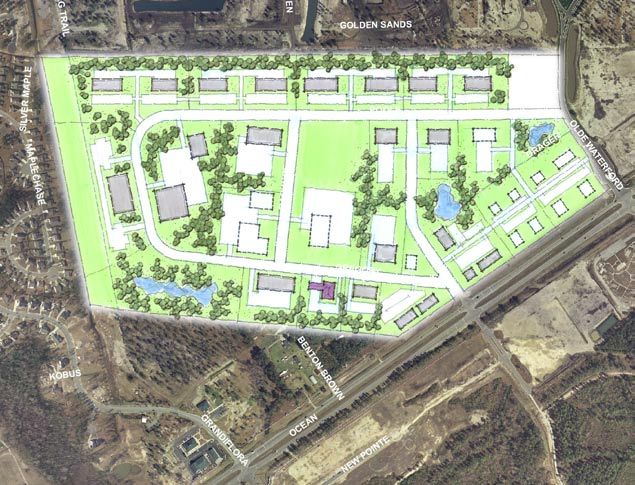
This Plan was Prepared For:
                                                                                                                                                                 The Town of Belville, North Carolina

                                                                                                                                                                                         Mayor and Town Council
                                                                                                                                                                                              David H. Long, Mayor
                                                                                                                                                                                 Mary Jean Rhodes, Mayor Pro-Tem
                                                                                                                                                                                 Charles M. Thurlow, Commissioner
                                                                                                                                                                                    Dennis L. Taylor, Commissioner
                                                                                                                                                                                   General R. Ennis, Commissioner

                                                                                                                                                                                              Town Administrator
                                                                                                                                                                                                     Tracie Davis

                                                                                                                                                                                                  Project Team

                                                                                                                                                                                          THE LAWRENCE GROUP
                                                                                                                                                                     Craig Lewis, AICP, LEED AP, Principal in Charge
                                                                                                                                                                                     Dave Malushizky, AIA, LEED AP
                                                                                                                                                                                              Tom Harrington, RLA
                                                                                                                                                                                                        S. Chad Hall
                                                                                                                                                                                              Beth Weast, LEED AP
                                                                                                                                                                                                  Amanda Huggins
                                                                                                                                                                                                          Trey Akers

                                                                                                                                                                                          ROSE AND ASSOCIATES
                                                                                                                                                                                             Kathleen Rose, CCIM

                                                                                                                                                                                   KIMLEY-HORN & ASSOCIATES
                                                                                                                                                                                        Mike Rutkowski, PE, AICP

                                                          © 2007 by Town of Belville, NC, and The Lawrence Group. Reproduction Permitted with Credit in Print.

                   The Belville VISION 2020 Plan   September 2007-Final                                                                                                               Acknowledgements
ACKNOWLEDGEMENTS   Belville, North Carolina                                                                                                                                                                      i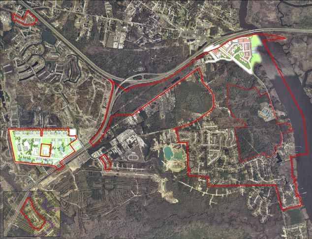
1 Executive Summary        			                       1

                                                       2 INTRODUCTION & ANALYSIS

                                                         2.1 Existing Conditions		        			               2
                                                         2.2 Market Analysis				                            3
                                                         2.3 Principles of Growth & Development		           6

                                                       3 CIVIC DIALOGUE AND PARTICIPATION

                                                        3.1 The Public Process		   			                      7
                                                        3.2 Kickoff Workshop      				                      8
                                                        3.3 The Charrette					                              9
                                                        3.4 Charrette Deliverables				                      11

                                                       4 plan RECOMMENDATIONS

                                                        4.1 Environmental Sustainabilty			                  12
                                                        4.2 Transportation & Circulation			                 14
                                                        4.3 Composite Master Plan				                       20
                                                        4.4 Lincoln Business Park/US 17				                 21
                                                        4.5 Blackwell Road Area					                        24
                                                        4.6 The Riverfront Village					                     26

                                                       A Appendix

                                                        A.1 Blackwell Road Area (Leland Jurisdiction)       35
                                                        A.2 NC 133 South		        			                       37

The Belville VISION 2020 Plan   September 2007-Final                                    Table of Contents
Belville, North Carolina                                                                                        ii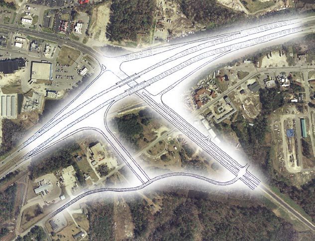
Executive summary
         The Town of Belville, which was incorporated in 1977, has a population           Riverfront Village: The old downtown is in need of more
         of approximately 1200 residents. Located in Brunswick County’s                   than a facelift; it requires a complete reconstruction. This plan
         northeastern corner along the Brunswick River and at the intersection of         conceptualizes a true urban, riverfront village with a boardwalk, new
         US 74-76, NC Highway 133 and US 17, the Town is located across the               Town Hall and public green accompanied by mixed-use buildings
         Brunswick and Cape Fear Rivers from Wilmington, a major deep-water               that create a lively town center. In addition, this sub-area contains                                               4
         port and historic riverfront downtown.                                           the community’s biggest transportation issue. The area around the
                                                                                          interchange has a series of key long-term investments that include
         Due to its proximity to the coast, the soil conditions and high water            the improvement of NC 133, the realignment of Blackwell Road,
         table contribute to a high amount of wetlands. These wetlands are                and a new northbound on- and off-ramp.                                                    2
         strewn throughout the community and are in various states of protection                                                                                                                                      3
         or degradation.                                                              With regard to the environment, this plan places a high priority on
                                                                                      the protection of the Town’s natural systems, namely the wetlands
         Largely a residential community, it is almost completely surrounded by       and watercourses. The quality of life for the residents of Belville is         1
         the Town of Leland. As a result, the two community’s futures are closely     closely intertwined with the quality of the natural habitat. Too much
         intertwined. This common future set the stage for the completion of two      degradation has occurred in this region, a trend that must be reversed
         separate but complimentary land use plans in 2007.                           with more sensitive development regulations.

         This Town Plan and its companion document, Belville Proposed Code            And finally, the transportation system must better reflect a more
         Changes-Technical Memo, represent a guide to the future development          balanced approach with greater choice. Not only should there be more
         and perhaps more importantly, the redevelopment of portions of the           street connections to disperse traffic and improve mobility, but the                                Planning areas
         Belville community.                                                          system must mature beyond the current car-only approach. The needs                                  1: Lincoln Business Park/NC 17
                                                                                      of bicyclists and pedestrians must be accommodated on new streets and                               2: Blackwell Road
         For the purposes of this plan, the community was divided into four           existing streets alike.                                                                             3: NC 133 South
         areas for detailed study. Areas that were not included are assumed to                                                                                                            4: The Riverfront Village
         remain intact with little change expected for at least twenty years. These   In the end, this plan seeks to answer the questions posed to it by the
         planning areas are summarized below:                                         Town’s residents. Namely, where should development go, what form
                                                                                      should it take, and how do we improve the overall community for the
             Lincoln Industrial Park/US 17: The existing light industrial             next generation? For a small coastal town with little room to grow, this
             operations and expanding retail have met recently with opposition        plan sets forth great ambitions. Yet, with stable, visionary leadership and   The composite plan
             from new neighbors along the northern and western boundaries.            prudent management, Belville can truly realize its dream of creating a
             This plan seeks ways to mitigate against future conflicts, while         community that maintains its distinctive small town character while
             preserving this valuable area for economic development activities.       balancing between aesthetics, growth and the environment.

             Blackwell Road: The scattershot industrial operations, old
             substandard homes, and new subdivisions all share the roads in
             this area. Noting the presence of a large undeveloped tract as well
             as tracts that needs to be either redeveloped or simply cleared
             of the existing use, this plan seeks to balance opportunities for
             aggressive environmental protection with improved circulation and
             connectivity to NC 17.

             NC 133 South: The number one traffic generator in Belville, the
             elementary school is also the center of this community. And, with
             the growing traffic volumes on NC 133, improvement in inevitable.
             This plan illustrate the timing and phasing of such improvements
             and the type of aesthetic that is necessary to continue the ambiance
             of this corridor.

         The Belville VISION 2020 Plan                       September 2007-Final                                                                                                        1: Executive Summary
         Belville, North Carolina                                                                                                                                                                                     1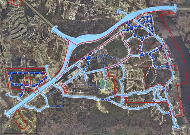
2.1 Existing Conditions

            I-140                                                    I-140                                                 I-140

                        US 17                         NC 133                 US 17                       NC 133                    US 17                           NC 133

                                      I-140/Skyway Connection                             I-140/Skyway Connection                                   I-140/Skyway Connection

                                  Regional Street                                    Floodplain and storm                                       Regional Map
                                  network                                            surge map                                                  The map above combines the two
                                  The map above shows the current                    The map above was developed                                maps to the left with the aerial
                                  street network in dark gray, the                   using computer models showing                              photography.
                                  Leland collector street plan in                    “worst-case scenarios” for flooding
                                  dashed-red, and the proposed I-                    at high tide for both slow moving
                                  140 in solid black.                                and fast moving storms.

          The Belville VISION 2020 Plan         September 2007-Final                                                                       2: Introduction & Analysis
          Belville, North Carolina                                                                                                                                            2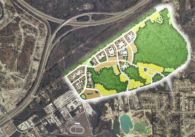
2.2 market analysis
          The following text is adapted from a Preliminary Market Study prepared                                                                            Factors impacting the Study Area
          for the Towns of Leland and Belville by Rose & Associates Southeast Inc.
          The preliminary study’s purpose was to establish the existing conditions                                                                          Regional Development Patterns
          in the north Brunswick area using readily available real estate and                                                                               Development patterns have spread from Wilmington’s historic
          demographic data. This report is not intended to serve as a definitive                                                                            downtown to the outlying areas along the rivers and primary
          assessment of any individual site but rather to give an overall assessment                                                                        transportation corridors. Land use has focused higher density, urban,
          of the trends in the marketplace and offer some subjective observations                                                                           commercial and mixed-use development along the river and ocean
          and recommendations consistent therein.                                                                                                           shorelines as well as the primary corridors of US Highways 17 & 74/76,
                                                                                                                                                            NC 421 & 133 and Interstate 40. A new bypass (I-140) is proposed
          Study Area Summary                                                                                                                                along the western edge of the Leland/Belville area.

          The Study Area includes the Township of Belville, with particular focus                                                                           These areas underscore the importance of coherent land-use planning
          on its riverfront and downtown area. The primary corridors include                                                                                to provide transitional areas between recreation/water areas, primary
          Highway 17 and NC 133 at the interchange along Highway 74/76.                                                                                     regional clusters of business/employment and retail centers. Quadrants
          The town is located in Brunswick County, and lies at the western edge                                                                             between these primary centers of influence have been rapidly developed
          of Wilmington and New Hanover County, west of the Cape Fear and                                                                                   for residential housing to serve the growing economic expansion of the
          Brunswick Rivers. In total, the Town encompasses approximately 3,000                                                                              Wilmington MSA (Metropolitan Statistical Area). As a result, the region
          acres.                                                                                                                                            now boasts one of the state’s fastest growth rates.
                                                                                                                           Wilmington Chamber of Commerce
          Current land uses are predominately low-density residential housing with                                                                          Transportation
          limited commercial facilities and civic/public uses.                            Regional Map Showing                                              The regional transportation network is firmly in place, providing access
                                                                                         the Key transportation                                             from other areas of the state. This includes a multi-modal approach with
          History & Perspective                                                            corridors in the area                                            highway, rail, air and port systems. The challenge now is to provide an
                                                                                                                                                            internal transportation network that connects these corridors, while
          Beginning in the early 1890’s, at the time the earliest plantations along                                                                         defining the community’s boundaries and character. The purpose of the
          the Cape Fear River were established, Belville offered riverfront access                                                                          master plan is to outline specific land use parameters that will assist in
          and served as a crossroads for commerce and transportation. This                                         north Brunswick                          defining these areas to balance commercial and residential uses.
          continued to evolve with the construction of bridges, and Highway                                        county area showing
          74/76 that provided primary east/west travel; and Highway 17,                                            the surrounding towns                    Economic Development
          providing north/south travel. These highways converge to form the                                                                                 Belville is competitively situated at the edge of Wilmington, the heart
          gateway into Wilmington, the region’s largest city. Since its inception,                                                                          of the MSA. The North Carolina State Department of Commerce is
          Belville’s land-use patterns evolved into a mix of agricultural, low-density                                                                      divided into seven regions and regional partnerships, including the
          residential and small-scale commercial uses.                                                                                                      Southeast Region with the Wilmington MSA at its center. Managed
                                                                                                                                                            by the Wilmington Ports Authority, Wilmington is one of six foreign
          These corridors and the communities they connect are the fastest                                                                                  trade zones in the State of North Carolina (Zone #66), . The Southeast
          growing areas of Brunswick County, which includes neighboring Leland,                                                                             Regional Partnership currently offers nearly 100 sites ranging in size from
          who has experienced record growth in the past five years. Feedback from                                                                           2 to 2,500 acres for economic development. Likewise, there are a small
          civic leaders, government representatives and residents suggests that the                                                                         number of industrial parks in the region such as the Lincoln Industrial
          community embraces their natural environment, relationship to the                                                                                 Park, which is situated within the town limits of Belville.
          rivers, quality of life and small town/rural character of the type found
          in suburban towns. Its challenge is to maintain its identity as the area
          experiences growth pressures, while creating a “sense of place” within a
          region that has evolved into a mix of uses, predominately commercial,
          along its primary corridors.

          The Belville VISION 2020 Plan                        September 2007-Final                                                                                                        2: Introduction & Analysis
          Belville, North Carolina                                                                                                                                                                                                 3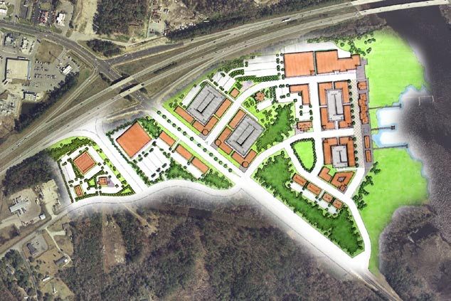
2.2 Market analysis
Market Potential
Market potential considers the economic status of a community,
demographic and socio-economic trends of its citizens, and quality of Oblique aerial image
life parameters—all of which determine the goals for both creating and
of belville, Leland, and
sustaining a market.
wilmington across the
Given its limited geographic size and demographic profile, the Town rivers
Source: Google Earth, 2007
will likely remain a predominately residential “bedroom” community,
with major shopping, employment and healthcare services provided in
neighboring Leland and Wilmington.
The primary target market for the commercial areas includes those
residents and businesses residing within the region. The secondary
target market includes retirees, business owners and lifestyle conscious
consumers drawn to the coastal areas from within the Southeast, and
finally those drawn to the Southeast from outside the region.
Importantly, Belville’s location along the Brunswick River distinguishes
it from neighboring communities. The old downtown area as previously
developed land and available for sale presents an opportunity that is
available only in Wilmington and along the intracoastal areas.
Findings & Recommendations
Review of the study area, data and demographic information, together
with preliminary interviews with key stakeholders of the community,
revealed the following observations:
Belville is a small town situated on the convergence of the Cape Fear
River, located in Brunswick County and the Wilmington MSA. The
Wilmington MSA and Brunswick County are among the fastest
growing areas of the state of North Carolina (third and fourth
respectively).
The Wilmington MSA along the southern Atlantic coastline is
driven by tourism, retail trade, real estate and recreation. The area’s
increasing popularity as a place for second homes and retirement
communities also drives much of the local economy.
Belville benefits from its proximity to Wilmington and neighboring
New Hanover County. Totaling only approximately 3,000 acres, it is Belville Downtown Wilmington
primarily a suburban residential community with a small downtown Leland
area that has suffered from decline.
Brunswick River Cape Fear River
Its coastal location within the Wilmington region, nearness to many
The Belville VISION 2020 Plan September 2007-Final 2: Introduction & Analysis
Belville, North Carolina 4
2.2 Market analysis
recreational and cultural attractions, together with accessibility via Neighborhoods of 16% of households moved from one location to another. Further,
air, waterways, rail and major transportation corridors makes the Transition from the riverfront village area to the existing low density mobility is higher in urban areas, where there is a higher percentage
Belville downtown and waterfront area ripe for revitalization and areas and neighborhoods with traditional single family housing . of renters versus owners and younger versus older households moving.
redevelopment. This will preserve Belville’s small town charm, particularly along the Though this varies by region, Brunswick County is no exception.
southern scenic corridor of Highway 133, as outlined in the Vision Plan. According to US Census Bureau estimates, in 2000, 54% of the people
Belville’s competitive advantages include its relationship to the Commercial development should be focused on downtown and existing living in the County were living in the same residence five years earlier;
river(s), accessibility, small town characteristics and infrastructure commercial business/industrial parks. However, small neighborhood 17% had moved from another residence in the same county, 13% from
(sewer plant). commercial uses (i.e.; drug/grocery/convenience stores) at primary another county in the same state, 15% from another state, and 1% from
intersections/nodes to service neighborhoods should be considered as the abroad.
Therefore, the plan recommends that the Town focus on priorities that community realizes the threshold populations needed to support such
would result in diversification of its tax base—to provide a balanced ratio uses. Demand for New Construction
between residential needs and commercial services to create a sustainable Analysis of the ratio between population and employment suggests that
local economy. These include: most Belville residents either travel outside of town to work or are not
Residential Uses-Target Markets employed. One indicator of new housing demand is the benchmark ratio
Re-create a town center, tied to the waterfront, to provide the between employment and building permits for new homes (E/P). A ratio
community a safe and pleasant area for commerce and community Housing greater than 1.0 indicates opportunities for new housing.
interaction, as well as a destination for tourists; The economic growth of a region includes growth in population and
households. Families moving to the region driven by the job market, Housing Product Types
Develop economic development strategies to balance tax base retirement or lifestyle changes provide opportunities for new housing in The key to creating a vibrant community is to have an active downtown
between commercial and residential land uses; areas where amenities and quality of life characteristics reflect changing core. Many downtowns heavily weighted with business uses are active
needs. These are both tangible and non-tangible components of what only during standard business hours, 5 days per week. Therefore to
Diversify the housing stock, to include townhomes, condominiums defines and drives a market. First we must understand the existing establish a vibrant downtown, in addition to drawing employees, local
and multifamily, to provide a variety of styles and price ranges for market, then determine market potential for new housing, which residents and visitors, housing must be part of the equation to attract
the target market segments. includes a variety of socio-economic factors including lifestyle, income/ residents who can live, work, shop and recreate in the downtown.
affordability and age.
Target markets include those with a preference for living in downtowns
Riverfront Village Area Data was collected for Brunswick County to benchmark the existing and more urban neighborhoods. Housing styles include a variety of
This area should be a mixed development focused around a public housing market. Based on increased costs for housing and rising interest options for rent or sale for a number of targeted buyer segments as
waterfront park. Competitive advantages include visibility and rates, greater growth is anticipated in the renter-occupied versus owner- outlined below, which will diversify the housing stock in Belville:
accessibility from all directions at the intersection of Highway’s 74, 17 occupied housing units as the affordability gap narrows and supply
and 133. Uses to include: increases. Housing Types - Riverfront Village Area
Single Family Detached 1 Unit Bungalow, Infill House
Retail - lifestyle/mixed use format; destination and entertainment Housing Characteristics Detached 2 Unit Duplex Bungalow, Infill House
oriented such as restaurants, theatres, bookstores, etc.; In 2000, Brunswick County had a total of 51,431 housing units. Of Multi-Family Attached 2-4 Units Urban Mansion
the total housing units, 55.7% were in single-unit structures, 8.2% Condominium, 1 Level Flat Multi-story, Urban
Office - Class A office above retail; 3-4 stories to serve growing were in multi-unit structures, and 35.9% were mobile homes. 37.5% Condominium, 2 Level Loft Multi-story, Urban
service related employment such as professional offices for real estate, of the housing units were built since 1990, with the balance being older
insurance, financial, legal and other services; Townhome, 1 Level Patio Home, Cottage
housing stock.
Townhome, 2 Level Rowhouse, Townhouse
Residential - High density housing including condominiums, Occupied Housing Unit Characteristics Townhome, 3 Level Rowhouse, Townhouse
townhomes and single family homes clustered around a mixed-use, In 2000, Brunswick County had 30,438 occupied housing units— Rental Apartments Garden Style; Multi-Story
town center format. 25,013 (82%) owner occupied and 5,425 (18%) renter occupied. Of Lofts Multi-Story, Urban
these totals, the County experienced homeowner vacancy rate of 3.8%,
Note: It will be important to consider elements of the Leland Conservation and a rental vacancy rate of 28.2%.
and Settlement Plan with respect to the Highway 133/Village Road area.
Beliville and Leland should collaborate to form a cohesive strategy for land Geographic Mobility
use in this critical north/south corridor. American households historically have been mobile. In 2005, an average
The Belville VISION 2020 Plan September 2007-Final 2: Introduction & Analysis
Belville, North Carolina 5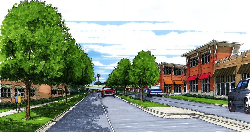
2.3 Principles of growth & development
In 2006, the Belville Board of Commissioners contracted with the Vision
Principles of Smart Growth What Is Smart Growth? to Action Group to assist them in developing a 5 year strategic plan
n Mix land uses Health, schools, taxes, traffic, the environment, economic growth, for the community. On May 22, 2006, the Board of Commissioners
n Take advantage of compact building design fairness, opportunity—many of the things we care about—are adopted a new Mission Statement and four key performance categories
n Create a range of housing opportunities and choices all affected by development decisions. From the length of our - Aesthetic and the Environment, Finance and Administration,
n Create walkable neighborhoods daily commute to the price of a new home to the safety of our Responsible Development, and Services.
n Foster distinctive, attractive communities with a strong sense neighborhoods—what, where, and how we build have major impacts
of place on our personal lives, our communities, and our nation. Mission Statement
n Preserve open space, farmland, natural beauty, and critical The Town of Belville is committed to maintaining its distinctive
environmental areas Growth presents a tremendous opportunity for progress. Communities small town character with a balance between aesthetics, growth and
n Strengthen and direct development towards existing around the country are looking for ways to get the most out of new the environment while providing quality customer service and fiscal
communities development and to maximize their investments. Frustrated by responsibility.
n Provide a variety of transportation choices development that requires residents to drive long distances between
n Make development decisions predictable, fair, and cost jobs and homes, many communities are challenging rules that make Specifically, this plan addresses the following priorities:
effective it impossible to put workplaces, homes, and services closer together.
n Encourage community and stakeholder collaboration in Many communities are questioning the fiscal wisdom of neglecting In the Year 2010:
development decisions existing infrastructure while expanding new sewers, roads, and services n We have upgraded the entrance to the town (Aesthetics and
As adopted by the Smart Growth Network into the fringe. And in many communities where development has Environment)
improved daily life, the economy, and the environment, smart growth n We have nature and/or biking trails (Aesthetics and Environment)
The Smart Growth Network has developed 10 fundamental goals that principles (see facing page) have been key to that success. n Hwy. 133 remains a scenic, residentially developed area
serve to implement these principles. (Aesthetics and Environment)
When communities choose smart growth strategies, they can create n We have a tree and shrub planting program (Aesthetics and
1. A Shot at the American Dream of Opportunity for All new neighborhoods and maintain existing ones that are attractive, Environment)
2. Safe, Convenient Neighborhoods With Homes That People convenient, safe, and healthy. They can foster design that encourages n Our town wetlands and heritage trees have been preserved
Can Afford social, civic, and physical activity. They can protect the environment (Aesthetics and Environment)
3. Development Decisions That Are Fair to Everyone while stimulating economic growth. Most of all, they can create more n We have a master plan in place for the downtown that takes
4. Investing Taxpayer Money Wisely in Our Communities choices for residents, workers, visitors, children, families, single people, into consideration the environment and appropriate ordinances
5. Protecting and Preserving Our Natural Heritage and Working and older adults—choices in where to live, how to get around, and (Responsible Development)
Lands how to interact with the people around them. When communities do n We have a master plan in place for commercial and residential
6. Freedom to Choose How We Get Around this kind of planning, they preserve the best of their past while creating areas that includes consideration for street plans, zoning and
7. Healthy Communities for All Ages a bright future for generations to come. aesthetics (Responsible Development)
8. Places Designed for People n We have a unified development code in place (Responsible
9. A Lasting Legacy in Our Communities From This is Smart Growth by the Smart Growth Network, 2006, available for Development)
10. Growth and Development That Improves Our Communities download at www.smartgrowth.org n We have worked to improve the intersection at Hwy 133
and 74/76 so it is safe, effective and accessible (Responsible
Development)
n We have an aesthetically pleasing mixed use development in the
downtown (Responsible Development)
Jonathan Spiers/The State Port Pilot
Jonathan Spiers/The State Port Pilot
n We have quality retail businesses in Belville (Responsible
Development)
n We have public, viable, open, green space (Services)
This plan reflects that mission and priorities as they relate to the
physical planning of the growth, development, and redevelopment of
the community. The elements listed above have been addressed through
various initiatives and planning concepts illustrated throughout this plan.
The Belville VISION 2020 Plan September 2007-Final 2: Introduction & Analysis
Belville, North Carolina 6
3.1 The Public process
           The consulting team used a four-day public planning and design
           workshop called a “charrette” to guide the Leland Town Master Plan
           process. This effort began with a public kickoff meeting on the evening
           of February 6, 2007 consisting of an opening presentation and an                              Town of Belville
           interactive workshop with area residents and stakeholders.
                                                                                                         Master Plan Schedule
           Following the kickoff meeting, the consulting team facilitated the
           public design charrette from February 19-22, 2007 in Belville’s Town
           Hall Annex. A temporary design studio was set up complete with design
           tables, meeting areas, computer equipment, and a presentation area.
                                                                                       Public Kickoff                             Tuesday, February, 20th
           Dozens of citizens, business and property owners, agency representatives    Tuesday, February 6th                      9 am    Utilities
           and public officials attended this comprehensive planning workshop          Kickoff Presentation and Public Workshop   11 am   Transportation/NC DOT
           during the four-day period. The consultant team held formal meetings                                                   Noon     Lunch Presentation of Market
           with specific stakeholders to discuss various topics related to the         Planning and Design Charrette                      Study by Rose & Associates &
           area’s future including: transportation, environmental infrastructure,      Monday, February, 19th                             Meeting with Town Board and
           schools, recreation, land development, utilities, economic development,     9 am     Design Team Arrives –                     Planning Board
           and development codes. At the same, the team’s designers and                         Charrette Studio Setup            1:30 pm    Environmental Protection
           transportation planners worked on concepts for the community in the         10 am   Walking/Driving Tour of            3 pm    Parks/Open Space/Recreation
           open design studio and met informally with dozens of citizens who
                                                                                                Community by Design Team          7:00 pm Public Workshop – Open
           dropped in to observe and comment on the charrette progress.
                                                                                       2 pm     Major Property Owners/
           The charrette concluded with a full digital presentation of the plan’s               Downtown Area                     Wednesday, February, 21st
           recommendations. The vision for the area, which will be used to guide       4 pm     Town Services                     9 am    Real Estate Agents/Developers
           Belville’s future growth, reflects the consensus gained by the area’s       7:00 pm Pin-up/Daily Update Session        11 am   Open
           interested residents and stakeholders, elected officials, staff, advisory                                              Noon    Lunch
           committee members and the consultant team during the course of the                                                     1 pm    Zoning Ordinance
           charrette.                                                                                                             3:30 pm Town Planning Board
                                                                                                                                          Workshop
                                                                                                                                  7:00 pm Pin-up/Daily Update Session

                                                                                                                                  Thursday, February, 22nd
                                                                                                                                  9 am    Open
                                                                                                                                  Noon    Lunch
                                                                                                                                  1 pm    Preparation for Closing
                                                                                                                                          Presentation
                                                                                                                                  6:00 pm Closing Presentation

           The Belville VISION 2020 Plan                      September 2007-Final                                                                             3: Civic Dialogue & Participation
           Belville, North Carolina                                                                                                                                                                7
3.2 kickoff workshop
On February 6, 2007 a kickoff presentation and workshop was Economic Development
conducted in the Town Hall Annex. More than 80 citizens and No more flea market retail
interested stakeholders were in attendance. The comments listed on this Belville Industrial park
page summarize the primary issues raised by those present. Increase commerce area to avoid bridge
Riverwalk: Shopping, Restaurants, Movie Theater, Small scale park
Downtown Restaurants!
Redevelop downtown
Maintain small town feel Civic/Cultural
Develop downtown so “I do not need to drive to Wilmington.” Move Town Hall back into Belville
Keep downtown as a distinct neighborhood New Town Hall!!!
Develop downtown as a mixed-use area Community center & library (downtown!)
Open the riverfront for public use Cinemas/Theater!
Community center!
Library Public Services
Riverwalk: Shopping, Restaurants, Movie Theater, Small scale park Large garbage pick-up
Provide separate, fun shops (ice cream/cookies) at riverfront Need police department
Remove the D.O.T. building from the waterfront Something done about trash all along the side of roads & parking lots
Get rid of current “downtown buildings & gas station” Water/Sewer infrastructure capabilities
Harbor Town: small local stores, restaurants, some condos (maybe Need curbside recycling
above retail), docks to bring boats in for day/dinner Low tax rate
More schools
Aesthetics Activity center with games for kids
Plant shrubs & trees bordering shops/sidewalks
Lots of benches, trees Parks/Public & Open Space
Keep park by river/school (2)
Transportation Protect wetlands
Make NC 133 three lanes through Belville Preserve trees & open space
Add sidewalks & bikeways on NC 133 and collector streets Multiple, small neighborhood playgrounds as opposed to one large
Improve infrastructure—roads community park
Options for Ploof Rd: Lower speed limit from 55 to 45 or 35; Repave Dog park (2)
roadway; Commercial traffic is shaking home foundations! Keep trees & green space (2)
Lower speed limits in the developments: Not 35—but 25!!!
Control traffic Environmental
Small-scale busing/public transit system Plan for storm water run-off on streets
Improve access (roads, feeder streets, connect neighborhoods) Keep wetlands protected; no development on them!
Water taxi to Wilmington Keep sound environmental principles
Traffic lights on Blackwell/Village Rd. (3) Keep: Green space
Off-street parking in new downtown
Miscellaneous
Pedestrian & Bikes Create cohesive boundaries: land-swap with Leland?
Sidewalks in Olde Towne (2)
Historical walking trail
Provide pathways for pedestrians & bikes, but give enough space so
they don’t endanger one another
Bikes/Walking paths (into downtown)
The Belville VISION 2020 Plan September 2007-Final 3: Civic Dialogue & Participation
Belville, North Carolina 83.3 the charrette
A charrette consists of an opening presentation, numerous public meetings, design sessions, pin-up
sessions, and a closing presentation, all conducted over a multi-day period. This intense and focused
effort gives the design team the most efficient opportunity to meet with a large number of interest groups
and citizens, gather their vision, and produce a detailed series of high quality plans and renderings that
accurately reflect the vision of the community.
There are four guiding principles for charrettes:
Involve Everyone from the Start: Anyone who might have an opinion or be affected by
the plan should be involved from the very beginning. By making people roll up their sleeves and work
with the design team, the process gains mutual authorship and a shared vision.
Work Concurrently and Cross-Functionally: Our design team has many different
specialties, but during the charrette, we all become generalists, assimilating everyone’s expertise and
reflecting the wisdom of each ability.
Charrette: French term for “little cart” Work in Short Feedback Loops: The public needs to be able to propose an idea and see it
referring to the final intense work designed for review in a short period of time. During our process, we hold pin-up sessions every day to
effort expended by architects to meet garner input on the preferred direction based upon what we heard earlier in the day.
a project deadline. At the Ecole des
Beaux Artes in Paris during the 19th
Work in Detail: Only through designing to a level of detail that includes both the details of
century, proctors circulated with carts
to collect final drawings, and students building types, blocks and public spaces as well as the big picture of circulation, transportation, land
would jump on the “charrette” to put use and major public amenities can fatal flaws be reduced or eliminated.
Images from the Charrette
The Belville VISION 2020 Plan September 2007-Final 3: Civic Dialogue & Participation
Belville, North Carolina 93.3 The charrette
Images from the Charrette
The Belville VISION 2020 Plan September 2007-Final 3: Civic Dialogue & Participation
Belville, North Carolina 103.4 charrette deliverables
Because of the charrette’s comprehensive nature, the master plan
proposed at that time provided enough detail to show realistic
development capacity for the remaining developable area using detailed
THE BELVILLE
schematic design studies in three dimensions including streets, buildings, Slides from the charrette’s
and open spaces. closing presentation
The design team delivered a PowerPoint Presentation that restated the
goals of the process, illustrated in detail the proposed plan and permitted
TOWN PLAN
Belville, North Carolina
the team to suggest a number of specific implementation strategies. The
digital nature of the final presentation enabled the Lawrence Group CHARRETTE NOTEBOOK
to produce both a high quality PowerPoint presentation illustrating THE LAWRENCE GROUP TOWN PLANNERS + ARCHITECTS
the draft Master Plan as well as published package of all of the final IN ASSOCIATION WITH
KIMLEY-HORN & ASSOCIATES
drawings. ROSE & ASSOCIATES
© THE LAWRENCE GROUP, 2007
Tr a n s p o r t a t i o n F r a m e w o r k
Existing Roads
Proposed Connections/New Town Streets
Important Intersections
Bike Lanes
Riverfront Pathway
THE BELVILLE
TOWN PLAN
Belville, North Carolina
THE LAWRENCE GROUP / KIMLEY-HORN & ASSOCIATES / ROSE & ASSOCIATES
© THE LAWRENCE GROUP, 2007
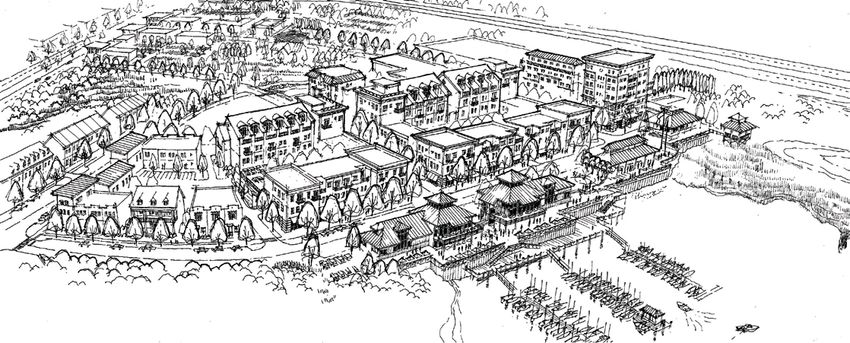
The Riverfront Village - Option B
pages from the THE BELVILLE
TOWN PLAN THE LAWRENCE GROUP / KIMLEY-HORN & ASSOCIATES / ROSE & ASSOCIATES
charrette notebook Belville, North Carolina © THE LAWRENCE GROUP, 2007
The Belville VISION 2020 Plan September 2007-Final 3: Civic Dialogue & Participation
Belville, North Carolina 114.1 Environmental sustainability
Introduction What is Low Impact Development (LID)?
Protection of Belville’s rich natural resources is a priority for the Town and its citizens. As such, development LID is an ecologically friendly approach to site development and storm water management that aims to mitigate
regulations should reflect this conviction. Sustainable design and development comprises two main areas of development impacts to land, water, and air. The approach emphasizes the integration of site design and planning
action: site design and building design. Parameters and guidance for sustainable building design are best set techniques that conserve natural systems and hydrologic functions on a site. The practice has been successfully
forth in the United States Green Building Council’s (USGBC) LEED standards (Leadership in Energy and integrated into many municipal development codes and storm water management ordinances throughout the United
Environmental Design) (www.usgbc.org). The LEED design criteria deal also with site design for the areas States. Specifically, LID aims to:
around the building(s), and these sustainable landscape practices are further codified by the Low Impact
Development (LID) standards, promulgated by, amongst others, the Low Impact Development Center (www. Preserve Open Space and Minimize Land Disturbance;
Protect Natural Systems and Processes (drainage ways, vegetation, soils, sensitive areas);
lowimpactdevelopment.org).
Re-examine the Use and Sizing of Traditional Site Infrastructure (lots, streets, curbs, gutters, sidewalks) and
Customize Site Design to Each Site;
Recommendations Incorporate Natural Site Elements (wetlands, stream corridors, mature forests) as Design Elements; and
Decentralize and Micromanage Storm Water at its Source.
Protect the wetlands and watercourses (creeks, streams, and rivers) with increased protection and suitable
undisturbed buffers. The Belville area, like most of the County, is strewn with various wetlands ranging from LID Benefits
boggy woodlands to ponds, streams and marshlands. The conventional development pattern has largely In addition to the practice just making good sense, low impact development techniques can offer many benefits to a
engineered much of these precious sites water quality benefits in favor of strictly water “quantity” measure. variety of stakeholders.
That is, the focus has been on the collection and transmission of storm water to prevent flooding. Little if any
For Municipalities
focus has been on the quality of the downstream water and its ability to support the natural systems that have
Protect regional flora and fauna
long been the basis for the area’s tourism. The Town should closely follow the requirements and categories
Balance growth needs with environmental protection
established by various North Carolina state authorities, especially the NC-CREWS (North Carolina Coastal Reduce municipal infrastructure and utility maintenance costs (streets, curbs, gutters, sidewalks, storm sewer)
Region Evaluation of Wetland Significance) Strategic Plan for Improving Coastal Management in North Increase collaborative public/private partnerships
Carolina (1999) and the North Carolina Wildlife Commission’s Guidance Memorandum to Address and
Mitigate . . . Impacts to . . . Wildlife Resources and Water Quality (2002). For Developers
Reduce land clearing and grading costs
The NC-CREWS plan notes that: Potentially reduce infrastructure costs (streets, curbs, gutters, sidewalks)
“approximately 50 percent of the original wetlands of the coastal area have been drained and converted to other Reduce storm water management costs
land uses (Hefner and Brown, 1985; Dahl, 1990; DEM, 1991). Although agricultural conversion, the largest Potentially reduce impact fees and increases lot yields
Increase lot and community marketability
historical contributor to wetlands loss, has largely stopped, wetlands continue to be lost as they are drained or
filled for development. Conflicts between economic development and wetlands protection continue to be a major
For the Environment
concern, with many coastal communities considering wetlands protection to be a major barrier to economic Preserve integrity of ecological and biological systems
development. Since wetlands are such a dominant part of the coastal landscape and are vitally important to Protect site and regional water quality by reducing sediment, nutrient and toxic loads to water bodies
many aspects of the area’s ecology, their management and protection is a major concern . . . Environmental Reduce impacts to local terrestrial and aquatic plants and animals
considerations play a significant role in land use decision-making and are one of the major objectives of the local Preserve trees and natural vegetation
land use planning mandated by the NC Coastal Area Management Act.”
Hydrologic Comparison between Conventional Storm Water Management and LID
In their companion report, the North Carolina Wildlife Resources Commission (NCWRC) notes that Hydrologic alterations within the landscape occur whenever land is developed. Conventional development approaches
“riparian” areas, that is, land areas along and adjacent to rivers, creeks and streams: to storm water management have used practices to quickly and efficiently convey water away from developed areas.
Usually these practices are designed to control the peak runoff rate for predetermined storm events, usually the 2- and
“frequently perform important ecological functions and contain a disproportionately high numbers of wildlife
10-year storms. While these systems have worked to some degree, they still have not accounted for the increased runoff
species in comparison to most upland habitats (Fischer et al. 2000; Knutson and Naef 1997). As a matter of
rates and volumes from smaller, more frequent storms, nor have they addressed the larger watershed functions of
policy, the American Fisheries Society strongly urges that riparian areas be considered unique and distinctly storage, filtration, and infiltration.
valuable habitats, and that such areas be declared of critical environmental concern (AFS 1985). Riparian areas
perform many functions that are essential to maintaining water quality, aquatic species survival, and biological In contrast, LID utilizes a system of source controls and small-scale, decentralized treatment practices to help maintain
productivity. . . The use of wooded riparian buffers is an important tool in reducing damage to streams (Waters a hydrologically functional landscape. The conservation of open space, the reduction of impervious surfaces, and the
1995) [and convey] critical benefits to society.” use of small-scale storm water controls, such as bioretention, are just a few of the LID practices that can help maintain
predevelopment hydrological conditions.
Source: Municipal Guide to Low Impact Development, National Assocation of Home
The Belville VISION 2020 Plan September 2007-Final 4: Plan Recommendations
Belville, North Carolina 124.1 Environmental sustainability
According the NCWRC, riparian areas provide the following benefits: and in the end, to better protect water quality. Not only can LID provide
Reduce pollutants and filter runoff a better scenario for water quality, it is often more cost effective.” In L.E.E.D
Improve air quality and lower ozone levels urban areas, these techniques will range from conventional underground Leadership in Energy & Environmental Design
Maintain stable water flows retention structures, to localized bioretention areas such as rain gardens
The LEED (Leadership in Energy and Environmental Design) Green Building
Help maintain water and air temperature by providing shade and planted swales as alternatives to large ponds, to permeable pavement
Rating System® was created to:
Stabilize stream banks surfaces (especially for parking areas), rain barrels and planted roofs.
Provide most of the organic carbon and nutrients to support the n Define “green building” by establishing a common standard of
aquatic food web Consider LEEDTM certification of all new public buildings. This measurement
Provide sources of large woody debris for the stream channel conceptual master plan encourages the use of LEED guidelines to certify n Promote integrated, whole-building design practices
Help reduce the severity of floods all new public buildings. Developed by the USGBC membership, n Recognize environmental leadership in the building industry
Facilitate the exchange of groundwater and surface water the Leadership in Energy and Environmental Design (LEED) Green n Stimulate green competition
n Raise consumer awareness of green building benefits
Provide critical wildlife habitat Building Rating System is a national consensus-based, market-driven
n Transform the building market
building rating system designed to accelerate the development and
At a minimum, adequate undisturbed buffers a minimum of 50 feet in implementation of green building practices. In short, it is a leading-edge
LEED provides a complete framework for assessing building performance and
width should be established around all wetland areas and watercourses. system for designing, constructing and certifying sustainable buildings. meeting sustainability goals. Based on well-founded scientific standards, LEED
Depending on the soil conditions and vegetation around the area, this emphasizes state of the art strategies for sustainable site development, water
buffer could be increased or decreased subject to existing best practices in The trend towards sustainable design practices in building also serves as savings, energy efficiency, materials selection and indoor environmental quality.
the coastal areas. a means to reduce overall energy LEED recognizes achievements and promotes expertise in green building
consumption. While there is often through a comprehensive system offering project certification, professional
Reduce the impact of parking areas on the environment with reduced a 2-10% increase in capital costs for accreditation, training and practical resources.
parking ratios and pervious pavement systems. The design of parking a LEED-certified building, these
areas is particularly critical in terms of controlling the amount of costs are recouped over a period of LEED standards are currently available or under development for:
surface water run-off from developments in the town center. Efforts time with lower heating, cooling
n New commercial construction and major renovation projects (LEED-NC)
to reduce parking lot acreage begin with minimizing required parking and water consumption costs. n Existing building operations (LEED-EB)
ratios; encouraging shared parking between uses; adopting and not n Commercial interiors projects (LEED-CI)
exceeding nationally recognized minimum parking dimensions (The n Core and shell projects (LEED-CS)
Dimensions of Parking, 4th ed. Urban Land Institute and the National n Homes (LEED-H)
Parking Association, 2001); grading parking lots to drain rainwater to n Neighborhood Development (LEED-ND)
multiple landscaped areas that can function as rain gardens to absorb
and slowdown water run off; and the use of pervious pavement materials Source: http://www.usgbc.org
such as interlocking concrete pavers (e.g. Grasscrete). Rain Barrel System to be used
for On- Site Irrigation
Incorporate Low Impact Development (LID) Standards into new
Credit: City of Seattle Public Works
development. The Town should investigate implementation of Low
Impact Development standards recently produced for Brunswick and
New Hanover Counties. According to the New Hanover County
Planning Department, “LID is an approach to site development and
storm water management with the goal being to mitigate development
impacts to land, water and air. LID incorporates comprehensive land
planning and engineering design in order to maintain or enhance
the predevelopment hydrologic regime of urban and developing
watersheds. LID incorporates various stormwater techniques to achieve
environmental protection, while allowing for development to occur.”
“Conventional stormwater techniques alone may not prevent the
continued degradation of water quality. LID provides an additional tool
to optimize the use of the urban landscape to reduce and treat runoff, Pervious Paving System to Improve Natural Drainage and Reduce Runoff A Rain Garden that collects stormwater and naturally “cleans” pollutants
The Belville VISION 2020 Plan September 2007-Final 4: Plan Recommendations
Belville, North Carolina 134.2 transportation & circulation
Introduction
Given the unique geography of the Belville town limits with its close
relationship to Leland, the railroad and the US 17 highway dividing
its borders, it is clear that most of the issues that face Belville residents
in getting around are regional in nature. In the car, on a bike, or by
foot, circulation around Town is inextricably linked to the decisions of
others. As such, it is imperative that Belville continue to actively assert
itself in all regional transportation planning efforts, most specifically the
Wilmington Area Metropolitan Planning Organization (MPO).
As a part of this planning process, Kimley-Horn & Associates reviewed
the existing transportation system and made a series of recommendations
for improvements. Because of this review’s qualitative nature, additional
study will be required for each recommendation. It is expected, however,
that these recommendations will provide a framework in which the Town
may begin to make some qualified decisions regarding future mobility.
The recommendations have been organized by the zones noted in the
diagram below:
4
2
3
1
Transportation Framework Plan
Building on the NC-133/US-17 Collector Street Plan, the plan Existing Roads
above illustrates the need for a more fine-grained network of multi-
modal (cars, bikes, and pedestrians) connections for the Belville area. Proposed Connections/New Town Streets
Proposed collector streets in Leland’s jurisdiction are grayed out.
Planning areas Important Intersections
1: Lincoln Business Park/NC 17
Bike Lanes
2: Blackwell Road (See also Section A.1)
3: NC 133 South
4: The Riverfront Village Multi-Use Path/Riverfront Pathway
The Belville VISION 2020 Plan September 2007-Final 4: Plan Recommendations
Belville, North Carolina 144.2 transportation & circulation
Planning Area 1: Lincoln Business Park/US 17
Olde Waterford Way
Provide a connection to Grandiflora Drive from Olde Waterford Way.
Connectivity is very poor in and around Leland and Belville. Extensive
wetlands, the presence of railroad tracks, US 74/76 and US 17 as limited
access highways and poor planning have contributed to a network
with few choices. The current network forces most trips onto US 17.
Better access is needed to connect the Waterford and Magnolia Greens
neighborhoods as well to the planned commercial/office development in “Back door”/street connection parallel to US 17
the business park and along the frontage of US 17.
In order to accomplish this connection, the Town of Leland should
preserve the corridor as part of an overall collector street program Connection to Grandiflora Drive
7
managed through the development process. It is expected that most US1
Gre
of this connection would be constructed by new development. This
g
Gra
ory
connection would complete the frontage road/cross-access driveway that nd
Ro
iflo
ad
ra
has already been started from Olde Waterford Way. With little effort D riv
this cross-access will connect to Gregory Road by extending individual e Planning Area 1
driveways. The remaining piece west of Gregory Road may need to take Transportation
a more northern route closer to Backhoe Road because of the presence of improvements
wetlands along US 17.
Planning Area 2: Blackwell Road 76
7/74/
U S1
Align Blackwell Road with Ploof Road to provide an east-west corridor d
Roa
for local traffic from NC 133 to Grandiflora Drive. Since the installation ell
ckw
of the improvements to US 17 (also know as the Michigan lefts), Bla
connectivity to US 17 westbound from Blackwell Road has been
eliminated. This access is now right-in/right-out only. Local drivers are
now aware that continuing down Blackwell and turning onto Ploof Road New street connections
enables westbound travel. Unfortunately, this route is not signed and is
generally unattractive. Blackwell Road/Ploof Road connector
o ad
To promote more local traffic along Blackwell Road and away from US ell Loop R
Chapp
17, this plan encourages the direct connection of Blackwell Road to
Ploof Road. To facilitate this new alignment, right-of-way will need to ad
be protected if the parcels in the path of such alignment are redeveloped. of Ro
Plo
In addition to simply providing a path for the motorist, a multi-use path
should also be provided to accommodate the bicyclist and the pedestrian.
New street connections
Ideally, this corridor should be extended to tie into the frontage road 17 Ploof Road connection to Wal-Mart
US
now presently installed in front of the new Wal-Mart. As is the case with
many of these connections, most lead into Leland’s jurisdiction and will
therefore require mutual cooperation and support.
Planning Area 2
Transportation
improvements
The Belville VISION 2020 Plan September 2007-Final 4: Plan Recommendations
Belville, North Carolina 154.2 transportation & circulation
Planning Area 3: NC 133 South
Improve the capacity of the NC 133/River Road corridor while
maintaining a high priority on its overall aesthetics as a gateway to
Belville and southern Brunswick County. NC 133 carries approximately
14,000 vehicles per day (vpd) just south of the US 17 interchange. With
more than 12,000 homes planned for Brunswick Forest and Mallory
Creek and only two points of combined external access, the amount of
traffic along NC 133 is expected to swell once those connections are
made.
The Southport area’s increased attractiveness for vacationing and the new
shipping port planned in that area will put even more pressure on this
corridor. Also, the planned (but unfunded) interchange of NC 133 and
I-140 to connect to the Skyway project (new bridge across the Brunswick
and Cape Fear Rivers to south New Hanover County) will dramatically
impact this area. Given the lack of short-term funding, however, such
impacts will be far into the future. Finally, Belville Elementary School’s
traffic and circulation is simply unacceptable during the morning rush
hour.
Though Belville’s preference is to keep this two lane winding rural road
in its present state, the need to improve and add additional capacity
is simply too inevitable. The goal, therefore, is to establish a new road
cross-section that maintains the majestic elements of the current corridor
while accommodating the needs of the increased travel projections.
Therefore, the following phased improvements should be considered
along the NC 133/River Road corridor: Proposed Cross-Section for NC 133/River road
The proposed ultimate cross section includes four travel lanes, a wide
n Short-term (2-5 years) – The section between the US 17/ landscaped median and side verges with canopy trees, and a wide
NC 133 interchange and Belville Elementary School presently sidewalk (or multi-use path) on each side. Ideally, the canopy trees
has 120 feet of right-of-way. This section should be widened selected could grow and over time, re-crate the existing feel of the rural
(between the interchange and Old River Road) to a 4-lane section with live oak branches creating a “low-country ceiling” over the
divided road with wide outside lanes (to accommodate cyclists), road like in the image to the left.
a lushly landscaped median with mountable curb, a verge with
street trees and 8 foot sidewalks through the village core. In
the area from Old River Road to Belville Elementary School/
Brunswick River Park the same cross section may be used, but
a 10 foot wide multi-use path should replace the 8 foot wide
sidewalk along the east side (Brunswick River side).
n Mid-term (5-10 years) – The section between Belville
Elementary School and the proposed Skyway (I-140) has only
60 feet of right-of-way. Using this existing right-of-way, this
section can be reconstructed to a 2-lane divided road with
a landscaped median and mountable curb, paved shoulders
and open swales. During this period, the Town should work
with adjacent property owners to continue the installation of
The Belville VISION 2020 Plan September 2007-Final 4: Plan Recommendations
Belville, North Carolina 164.2 transportation & circulation
sidewalks and street trees using permanent sidewalk easements.
Concurrently, the Town and NC DOT should aggressively
pursue additional right-of-way (25 feet on each side) to
accommodate a similar road section listed in the Short-term
phase above. Multi-use path along NC 133/River Road
n Long-term (10+ years) – Once adequate right-of-way (110 feet)
is acquired, the section between Belville Elementary School and
the Skyway should be widened to a 4-lane divided cross-section
with street trees and a multi-use path on each side.
Request that the NC DOT Urban Municipal Operations Unit conduct
Phase
an access and circulation study around the elementary school. The
1 Imp
current circulation around the school during student drop-off and Right-of-way needed in front of school
pick-up times is unacceptable. As NC 133 provides the only north-
rovem
south route in this entire area, all times of the day, but in particular the
ents
morning rush hour, stretch the roadway’s effectiveness. It is imperative
that alternate arrangements be considered to remedy the situation. The
conceptual plan drawn for the property around the Elementary School
provides a dramatic opportunity for positive change in this area. As such,
any site planning done on this parcel should keep in mind the needs of
circulation around the school.
Need an additional 40-50 of right-of-way (20-25 ft
from each side)
Phase
2 Impr
oveme
s nt
Planning Area 3
Transportation
improvements
The Belville VISION 2020 Plan September 2007-Final 4: Plan Recommendations
Belville, North Carolina 17You can also read