TASMAN DISTRICT COUNCIL FORESTS TASMAN DISTRICT COUNCIL - Owned by Forest Management Plan
←
→
Page content transcription
If your browser does not render page correctly, please read the page content below
TASMAN DISTRICT COUNCIL
       FORESTS

       Owned by
TASMAN DISTRICT COUNCIL

   Forest Management Plan

    For the period 2020 / 2024

                                       Prepared by: Sarah Orton
                     PO Box 1127 | Rotorua 3040 | New Zealand
                             P: 64 7 921 1010 | F: 64 7 921 1020
                       E: info@pfolsen.com | www.pfolsen.com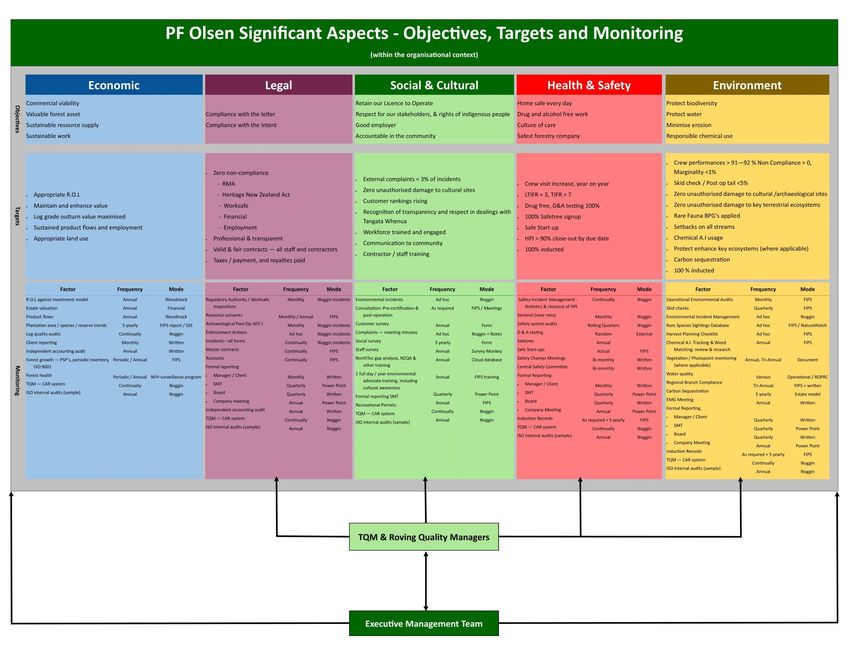
FOREST MANAGEMENT PLAN FSCGS04
                                                                                                TASMAN DISTRICT COUNCIL FORESTS

Table of Contents
Introduction..............................................................................................................................................2
Forest Landscape Description ..................................................................................................................3
The Broader Landscape ..........................................................................................................................10
Socio-economic profile and adjacent land .............................................................................................20
REGULATORY ENVIRONMENT AND RISK MANAGEMENT ......................................................................24
1.          The Regulatory Environment .....................................................................................................24
2.          Commercial Risk Management..................................................................................................32
3.          Environmental Risk Management .............................................................................................33
THE MANAGED PLANTATION ESTATE ....................................................................................................38
4.          Commercial Plantation Estate ...................................................................................................38
5.          Commercial Crop Establishment and Silvicultural Operations..................................................41
6.          Harvesting Strategy and Operations .........................................................................................44
7.          Forest Inventory, Mapping and Forest Records ........................................................................47
NON-COMMERCIAL ESTATE MANAGEMENT & PROTECTION ................................................................48
8.          Protected Forests, Habitats, Ecosystems and Species ..............................................................48
9.          Property Management and Protection .....................................................................................58
OTHER BENEFITS FROM THE FOREST .....................................................................................................62
10.         Recreation, Forest Products and Other Special Values .............................................................62
11.         Monitoring .................................................................................................................................65
12.         Future Planning .........................................................................................................................68
13.         Register of Plan Change and Review .........................................................................................69
Appendix 1 – Legal Descriptions ............................................................................................................70
Appendix 2 – Forest Neighbours ............................................................................................................72
Appendix 3 – Neighbour Location Maps ................................................................................................74
Appendix 4 – Contact details for Regional and District Councils with jurisdiction over Council
      Estate Forests ............................................................................................................................80
Appendix 5 – Other Relevant Legislation ...............................................................................................81
Appendix 6 – PF Olsen Significant Aspects: Objectives, Targets and Monitoring ..................................83
Appendix 7 – Marlborough Regional Pest Management .......................................................................84
Appendix 8 – Crop Status .......................................................................................................................85

                           ©     PF OLSEN LTD
                                 All rights reserved.
                                 All rights of copying, publication, storage, transmission and
                                 retrieval in whole or part by any means and for all purposes
                                 except for bona fide copying by the entity that commissioned
                                 this report, as set out on the title page, are reserved.

JUNE 2019                                                        TABLE OF CONTENTS                                                                            Page 1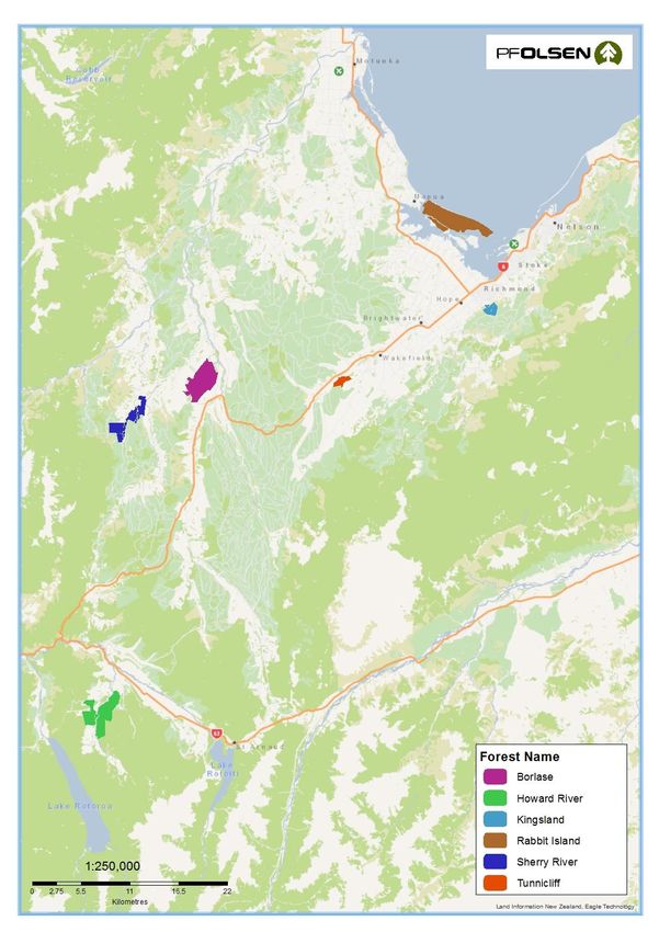
FOREST MANAGEMENT PLAN FSCGS04
                                                                 TASMAN DISTRICT COUNCIL FORESTS

Introduction

Principles and    Tasman District Council is committed to adopt the Forest Stewardship
Criteria          Council (FSC) Principles and to meet their Criteria and the FSC standards of
                  good forest management. These standards include ecological, social and
                  economic parameters.

                  Tasman District Council is committed to the PF Olsen FSC Group Scheme
                  that is implemented through the Group Scheme Member Manual and
                  associated documents.

About this Plan   This document provides a summary of the forest management plan and
                  contains:
                  •   Management objectives;
                  •   A description of the land and forest resources;
                  •   Environmental safeguards;
                  •   Identification and protection of rare, threatened and endangered
                      species;
                  •   Rationale for species selection, management regime and harvest plan
                      and techniques to be used;
                  •   Appropriate management of unstocked reserve areas;
                  •   Maps showing plantation area, legal boundaries and protected areas;
                  •   Provisions for monitoring and protection.

JUNE 2019                          The Regulatory Environment                                    Page 2
FOREST MANAGEMENT PLAN FSCGS04
                                                                 TASMAN DISTRICT COUNCIL FORESTS

Forest Landscape Description

Overview          This section describes the physical and legal attributes of the land on
                  which the forests are located. Included in this section are discussions of:
                        •     Location and access;
                        •     Topography;
                        •     Soils;
                        •     Climate;
                        •     Legal ownership and tenure.

Legal ownership   The tenure of all land is freehold except for Moturoa / Rabbit Island which
                  has been vested to the Council for plantation purposes under the
                  provisions of the Reserves and Other Land Disposal and Public Bodies
                  Empowering Act 1920.

                  An area of Kingsland forest is held as a reserve for waterworks purposes.

                  Small areas adjacent to Howard forest have Forestry Rights assigned to
                  two different parties, with the Council receiving a share of net returns at
                  harvest. A further Forestry Right at the Sherry River forest is held over a
                  small area of Douglas-fir trees; however, the Council receive no share of
                  harvest revenue.

                  The legal descriptions of the land on which the Council forests are situated
                  on are contained in Appendix 1.

Location and      The Tasman District Council (Council) has forests at six different locations
access            in the Nelson Region. The small Eves Valley forest, also part of the Council
                  forest estate, is excluded from coverage under this Plan as its primary
                  purpose is to complement the Eves Valley landfill operations.

                  Moturoa / Rabbit Island is located approximately 11km by road west of
                  Richmond off State Highway 60.

                  Borlase is located approximately 45km south-west of Richmond. The main
                  access is located off SH6.

                  Tunnicliff is located approximately 21km south of Richmond. The main
                  access is located off SH6.

                                                                        Continued on next page…

JUNE 2019                          The Regulatory Environment                                     Page 3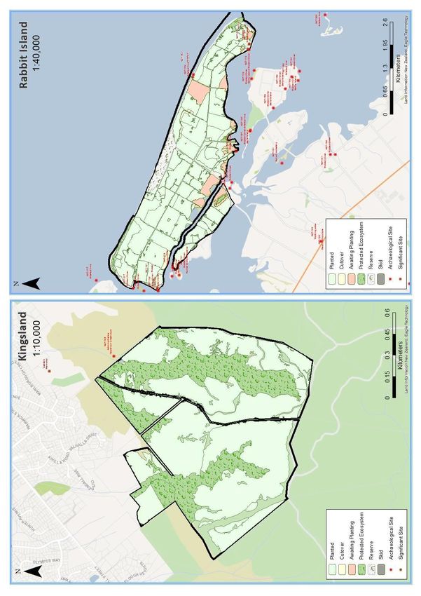
FOREST MANAGEMENT PLAN FSCGS04
                                                           TASMAN DISTRICT COUNCIL FORESTS

…continued
             Kingsland is located off Hill Street, Richmond at the southern end of Harts
             Road on the Richmond Hills, approximately 4km from central Richmond.

             Sherry River is located in the Sherry River Valley approximately 15km
             south-west of Tapawera and 60km south of Richmond.

             Howard is located approximately 110km by road south-west of Richmond
             off SH 63. It is located on the true right-hand side of the Howard River.

             All forests have a good network of roads and tracks although in some cases
             substantial upgrades will be required at time of harvest.

             The location of the forests in relation to Port Nelson is listed in Table 1
             below and shown in Map 1. Major log processing facilities are located
             within 25km of the Port.

             Table 1: Distances from forest to log markets

                                                              Distance from
                                        Forest
                                                                Port (km)
                             Moturoa / Rabbit Island                25
                             Borlase                                60
                             Tunnicliff                             35
                             Kingsland                              20
                             Sherry River                           75
                             Howard                                105

Topography   Moturoa / Rabbit Island
             The topography is predominantly flat with some rolling sand dunes. All
             harvesting is using ground-based systems. The altitude ranges from 0 to 10
             metres above sea level.

             Borlase
             Rolling to steep hill country. Slopes range from 10 to 25 degrees.
             Harvesting is suited to mainly hauler-based systems.

             Tunnicliff
             Rolling to moderately steep hill country. Slopes range from 10 to 25
             degrees. Harvesting is suited to ground-based systems.

             Kingsland
             Slopes are steep ranging from 20 to above 45 degrees. Harvesting is suited
             to hauler-based systems.

                                                                   Continued on next page...

JUNE 2019                    The Regulatory Environment                                        Page 4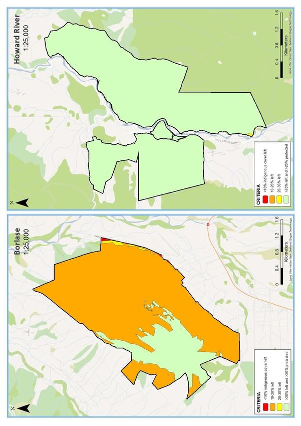
FOREST MANAGEMENT PLAN FSCGS04
                                                                       TASMAN DISTRICT COUNCIL FORESTS

…continued
                       Sherry River
                       Rolling to moderately steep hill country with large areas of flat river
                       terraces. Harvesting is suited to a mix of ground based and hauler systems.

                       Howard
                       Strongly rolling to moderately steep dissected terraces. Slopes are short
                       and range from 20 to 35 degrees with large areas of flat terraces.
                       Harvesting is suited to a mix of ground based and hauler systems.

Soils and geology      The Council forests occupy a wide range of soil types and geology. In
                       general, these are well suited to plantation forestry and impose few
                       constraints for tree growth. Occasionally the addition of fertiliser is
                       required to elevate levels of boron, phosphate and nitrogen.

                       Erosion risk is generally low-moderate and there are few environmental
                       risks associated with roading and harvesting when industry best practice is
                       applied. Soils are mostly stable however when soil conditions are wet
                       windthrow can occur in combination with strong winds.

                       The NZ Land Resource Inventory classifies the entire area into the
                       following units (Table 2):

Table 2: Soil types within the forest estate
                    VIIe 11
                    Geology:            Moutere and Old Man gravels from weathered greywacke
                                        and granites
      Borlase
                    Soil (general):     Hill soils, related to yellow grey earths
                    Erosion:            Slight sheet; gully and soil slip erosion
                    Nutrient Status:    Low
                    VIe 25
                    Geology:            Uncemented gravels and conglomerate
                    Soil (general):     Hill soils related to lowland yellow-brown earths
                    Soils (specific):   Howard silt and clay loams (rolling lands)
      Howard
                                        Howard clay hill soils
                                        Kawatiri silt top stone hill soils
                    Erosion:            Slight sheet and soil slip erosion
                    Nutrient Status:    Low
                    VIIe 3
                    Geology:            Maroon and grey banded argillite
                    Soil (general):     Steepland soils related to lowland yellow-brown earths
    Kingsland
                    Soils (specific):   Whangamoa steepland silt loams and stony loams
                    Erosion:            Sheet and scree erosion
                    Nutrient Status:    Low to medium
                                                                          Continued on next page...

JUNE 2019                                The Regulatory Environment                                   Page 5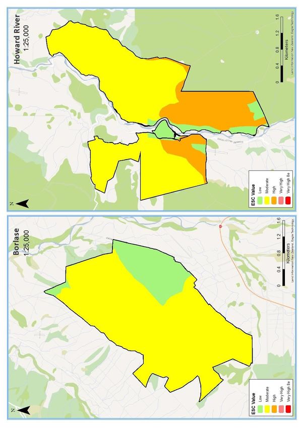
FOREST MANAGEMENT PLAN FSCGS04
                                                                   TASMAN DISTRICT COUNCIL FORESTS

…continued

                  VIe 24
                  Geology:            Beach gravels and dune sands from greywacke & granite
   Moturoa /      Soil (general):     Yellow-brown sand
  Rabbit Island   Soils (specific):   Tahunanui sand and fine sand
                  Erosion:            Slight to moderate wind erosion
                  Nutrient Status: Low
                  Floodplains llls2 & lVs3
                  Geology:            Uncemented gravel
                  Soils:              Sherry sand and Sandy loam. Formed on granite alluvium
                  Erosion:            Potential for slight stream bank erosion
                  Nutrient Status: Fertility is very low, and soil has very low levels of
                                      potassium, phosphorous and calcium. Soils are very acid
                                      and deficiencies in boron may occur
                  Sandstones and Mudstones Vlle4, Vle6 & Vle18
                  Geology:            Soft sandstone and mudstone
                  Soils:              Tadmor Hill soils. Formed on siltstone and sandstone on
   Sherry River                       moderately steep hills
                  Erosion:            Potential for slight soil slip and sheet erosion
                  Nutrient Status: Topsoils are generally shallow
                  Granite Formations Vlle25, lVs13 & Vle21
                  Geology:            Coarse crystalline rock
                  Soils:              Glenhope steepland soils and Kaiteriteri sandy loam. Found
                                      on very steep slopes or gently sloping country and formed
                                      on deeply weathered granite
                  Erosion:            Potential for slight soil slop and sheet erosion
                  Nutrient Status: These soils are formed under high rainfall and have very
                                      low fertility
                  VIe 16
                  Geology:            Deeply weathered greywacke gravels, overlying lignite and
                                      clay
                  Soil (general):     Hill soils related to yellow-grey earths or yellow-grey to
     Tunnicliff                       yellow-brown earth intergrade
                  Soils (specific):   Spooner Hill silt loams and stony loams
                  Erosion:            Slight sheet and soil slip erosion
                  Nutrient Status: Low

JUNE 2019                            The Regulatory Environment                                    Page 6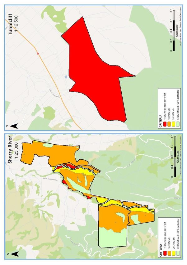
FOREST MANAGEMENT PLAN FSCGS04
                                                                   TASMAN DISTRICT COUNCIL FORESTS

Climate             The climate of the Nelson region is moderate with cool winters. Summer
                    droughts can occur, and occasional sub-tropical origin storms can bring
                    periods of intense rainfall and strong winds. Overall Nelson enjoys one of
                    New Zealand’s most pleasant climates with high sunshine hours and is
                    ideal for tree growing with few extremes.

                    The mean annual temperature, measured at Nelson airport is 12.1
                    degrees, with 89 days of ground frost per year. Wakefield, the epicentre of
                    Council’s forests, receives around 1200 mm per year of rainfall.

                    The forests closest to the coast receive around 920 mm rain per year while
                    the Howard receives the highest rainfall of about 1500 mm per year.

                    Highest rainfalls for all forests occur during September-October and the
                    lowest rainfalls in January-February. In general rainfall is relatively evenly
                    distributed throughout the year and is adequate for good tree growth
                    although occasional low summer rainfalls limit tree growth during this
                    period.

Forestry rights and Howard Valley
mining licences     Parts of the following blocks of Howard Forest are subject to a transfer
                    grant of forestry rights for 30 years (P. radiata) and 40 years (D. fir)
                    involving a joint venture with Martin Wells.
                    1.    Sections 13, 14, and 15 Block XIV Howard Survey District being a
                          block of 224.7876 ha, of which 6.6 ha P. radiata and 11.1 ha D. fir
                          planted 1992. Total Forest Right area equals 17.7 ha.
                    2.    Part Section 36 and 37 Block X Howard Survey District being 142.807
                          ha (access track only).

                    Tasman District Council to receive 16% of stumpage at harvest.

                    Parts of the following blocks of Howard Forest are subject to a similar
                    transfer grant of Forestry Rights for 40 years involving a joint venture with
                    D and A M Bier:
                    1.    Section 9 Block X and Section 16 Block XIV Howard Survey District
                          being 314.4406 ha (access track only).
                    2.    Section 12, Block XIV Howard Survey District being 196.6772 ha, of
                          which 31.0 ha P. radiata 1992, and 36.0 ha D. fir planted 1993. Total
                          Forest Right area equals 67.0 hectares.

                    Tasman District Council to receive 20% of stumpage at harvest.

                                                                          Continued on next page...

…continued

JUNE 2019                            The Regulatory Environment                                       Page 7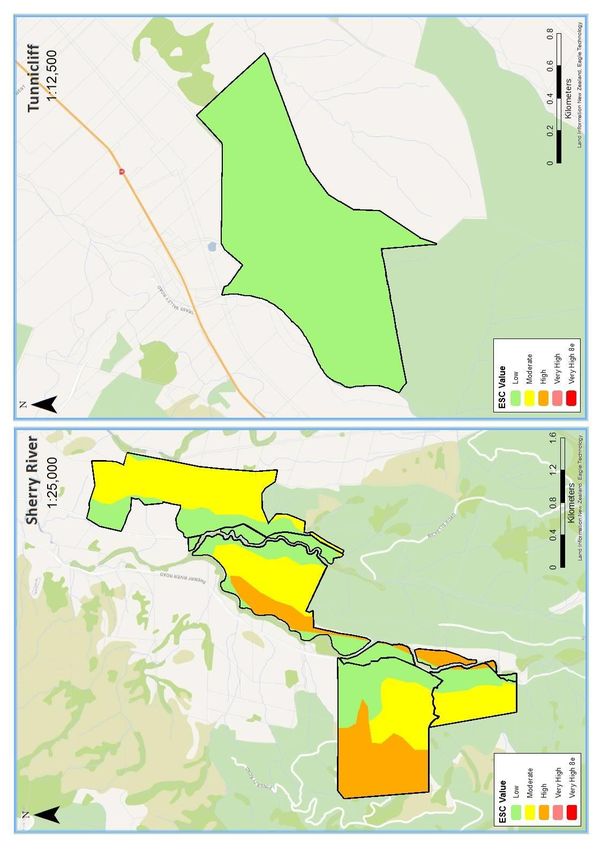
FOREST MANAGEMENT PLAN FSCGS04
                                                           TASMAN DISTRICT COUNCIL FORESTS

            A mining licence in favour of Lewis Creek Mining Society Ltd, C/- Rotoiti
            Community Council for a term of twenty years commencing 15 December
            2004 is held over Sections 13, 14 and 15 of Block XIV Howard Survey
            District.

            Sherry River
            The property has a 99.4-hectare Forestry Right on it with the Shirtcliff’s in
            the south western corner of the block. The Forestry Right involves:
            1.    The Grantee harvesting P. radiata prior to the trees reaching 30
                  years of age, and Douglas-fir/Larch prior to age 45.
            2.    Rates are payable by the Grantee until clearfell.
            3.    The Tasman District Council does not receive any percentage share
                  of stumpage at harvest.

            The block is progressively being felled and land handed back to Council for
            replanting. Areas of 18.6 ha, 7.7 ha 31.9ha and 2ha have been harvested
            planted by TDC in 2002, 2003, 2010 and 2012 respectively.

            The last remaining area to be harvested is 7.4ha of Douglas-fir which was
            planted in 1982, the forestry right will expire for these trees in 2027.

JUNE 2019                    The Regulatory Environment                                     Page 8
FOREST MANAGEMENT PLAN FSCGS04
                                                       TASMAN DISTRICT COUNCIL FORESTS

Map 1 – Forest Location Map

JUNE 2019                The Regulatory Environment                               Page 9
FOREST MANAGEMENT PLAN FSCGS04
TASMAN DISTRICT COUNCIL FORESTS
The Broader Landscape
Ecological landscapeThe Council forest estate is geographically diverse and falls within several
different Ecological Districts (ED’s_ (Table 3). Several forests also fall across
the border of several EDs, as shown below.
Table 3: Forest by Ecological District
Ecological District Bryant Motueka Moutere Arthur Rotoroa
Kingsland ✓ ✓
Tunnicliff ✓ ✓
Moturoa / Rabbit ✓
Island
Sherry River ✓ ✓
Borlase ✓
Howard ✓
Bryant
The Bryant Ecological District steep hill country comprised of a complex
matrix of argillite, sandstone, mafic, ultramafic, greywacke and marine
sediments. As a result, fertility and drainage varies significantly. The
district includes Dun Mountain which is a unique mafic volcanic area with
toxic soils and associated rare flora species assemblages.
Elsewhere, indigenous vegetation is restricted to the hills in the east and
south, with mixed beech-podocarp forests at higher altitudes, moving into
manuka dominated scrub down the altitudinal gradient. The coastal
Boulder Bank provides habitat for Arctic breeding and NZ migratory
waders, whilst the forests are home to falcon, kaka, kea, blue duck and
yellow-crowned parakeet. Various skinks and geckos are also found along
the rocky coast and tall forest.
Whilst areas of the district remain in tall forest and scrub, much has been
replaced by sheep and beef farming and exotic plantation forest. Goat and
pig damage is evident along the Bryant Range.
Motueka
The Motueka Ecological District is a small lowland district of plains
dissected by the Moutere District hill country. Geological influences
include the terrestrial and coastal alluvium at the coastal end, and terraced
Moutere gravels within the remainder.
Continued on next page...
JUNE 2019 The Regulatory Environment Page 10FOREST MANAGEMENT PLAN FSCGS04
TASMAN DISTRICT COUNCIL FORESTS
…continued
Originally most of the district was forested with podocarp/
hardwood/beech and smaller areas of raupo/flax wetlands. Polynesian and
European arrival saw much of the forest cleared and wetlands drained.
Extensive estuaries in the district provide habitat for more than 50 species
of estuarine birds, including Arctic breeding migrants and banded rail and
marsh crake. The common land use types today in the district (dairy
farming, sheep and beef, horticulture) offers little habitat for other native
species.
Moutere
The Moutere Ecological District is a lower altitude district, ranging from
800m to sea level. The geology is not complex, being almost entirely
Pleistocene deeply weathered Moutere gravel, overlying lignite and clay
with impeded drainage and moderate to low fertility.
The district was once fully forested with beech dominant forest types, with
the addition of podocarps and hardwoods- totara, matai, rimu, miro,
kahikatea in wide valley floors, and tawa, pukatea, titoki, karaka, matai,
nikau closer to the coast. Much of the more complex hardwood/podocarp
forest has been cleared, with only small isolated remnants remaining. One
significant tract of beech forest remains, which is habitat for kaka, falcon
and parakeet. Banded dotterel, pied stilt and black-fronted tern breed
along the Motueka River.
Much of the lower district is now in extensive sheep and beef farming,
horticulture and exotic plantation forest.
Arthur
The Arthur Ecological District is mostly mountains and hills 600m to 1500m
above sea level, draining NE into Tasman Bay. It has a complex geological
history, with marble, indurated mudstone, granite, and a range of schist
and quartz subtypes. Most of the District is covered in montane and
submontane indigenous vegetation, owing to the higher altitude and
terrain. Podocarp and podocarp/beech types are common in the lower
slopes and valleys, moving into red-silver-black-mountain beech species up
the altitudinal gradient. Above the tree line, the vegetation types are low
shrubland, tussock land and herb fields.
The high remaining proportion of indigenous forest has allowed the
persistence of kaka, blue duck, falcon, kea, and yellow-crowned parakeet
throughout the ED, and Great Spotted kiwi in the southern end. Nelson
Green gecko and several giant snail Powelliphanta species can be found in
the Arthur Range.
Continued on next page...
JUNE 2019 The Regulatory Environment Page 11FOREST MANAGEMENT PLAN FSCGS04
TASMAN DISTRICT COUNCIL FORESTS
…continued
Rotoroa
The Rotoroa Ecological District is predominantly hill country, with shallow,
stony gneiss and granite derived soils of low fertility. The district is
predominantly still in tall red/silver/mountain beech forest, with
podocarps present on warmer slopes. The extensive montane and
submontane forests are habitat for Great Spotted kiwi, falcon, kea and
kaka, plus several skink and gecko species.
Although much of the district remains as intact tall native forest, there are
areas of more intensive sheep and beef, and exotic plantation at lower
altitudes.
Protective status Table 4 shows vegetation types as required by the National Standard for
Plantation Forest Management in New Zealand revised in 2013.
JUNE 2019 The Regulatory Environment Page 12FOREST MANAGEMENT PLAN FSCGS04
TASMAN DISTRICT COUNCIL FORESTS
Table 4: Protective status of the ecological landscape
Howard Moturoa /
Forest Borlase Kingsland Sherry River Tunnicliff
River Rabbit Island
Motueka and
Ecological District Moutere Rotoroa Bryant and Motueka Motueka Arthur and Moutere
Moutere
LENZ type LENZ E1.1 LENZ P5.1 LENZ E1.1 LENZ E1.1 LENZ P6.2 LENZ B1.1
Original (pre-Maori) percentage
204,741 ha 186,678 ha 204,741 ha 204,741 ha 372,085 ha 55,526 ha
of ecosystem type in Ecological
100% 100% 100% 100% 100% 100%
District within land title
Natural ecosystem area 83,944 ha 130,675 83,944 ha 83,944 ha 305,110 ha 4,720 ha
remaining 41% 70% 41% 41% 82% 8.5%
Proportion of remaining natural 14,270 ha 98,006 14,270 ha 14,270 ha 256,292 ha 316 ha
ecosystem under protection 17% 75% 17% 17% 84% 6.7%
Protection by certificate holder 97.8 ha 121.7 ha 34.9 ha 17.1 ha 11.4 ha 3.4 ha 15.2 ha
Protected areas as a % of
14.6% 21.1% 29.3% 1.6% 11.6% 17.6%
management estate
Protected areas as a % of the
aggregated Group Scheme Bryant = 24.2% Arthur = 16.8% Motueka = 0.6%
10.5% 21.1% 1.5%
management estate by Motueka = 2.7% Moutere = 1.4% Moutere = 1.3%
Ecological District
JUNE 2019 The Regulatory Environment Page 13FOREST MANAGEMENT PLAN FSCGS04
TASMAN DISTRICT COUNCIL FORESTS
Historic and Records of known archaeological and historical places are maintained in the
archaeological NZ Archaeological Association (NZAA) Site Recording Scheme. The
sites Archaeological Site Probability model published by the Department of
Conservation1 provides further guidance on the probability of pre-European
archaeological evidence existing based on the geographical location of the
forests and historical occupation of the local area.
If a site is found or suspected on any block, the protocols specified in
PF Olsen’s EMS, and any others specifically developed in conjunction with
Heritage New Zealand (HNZ) and Iwi or other stakeholders must be observed.
Where such circumstances require, an ‘Authority to Modify or Destroy’ will be
sought from HNZ. Such authorities are similar in function to a resource
consent and, if granted, normally come with conditions that must be met. The
process to apply for authorities is documented in PF Olsen’s EMS.
Note also that Authorities to Modify an archaeological site may sometimes be
required from the local District Council and sites of cultural significance are
often included in schedules of places and sites of significance in District Plans.
Update checks for any sites will be required before any harvesting or related
earthworks commences.
The locations of the NZAA sites relative to the forests are shown in Table 5
and on the forest stand maps in Section 13.
There are also several areas identified to be ‘of-interest’ within Moturoa /
Rabbit Island by the local iwi group Tiakina te Taiao. To date, no finds /
discoveries of sites or artefacts have been made within the areas. No biosolid
spraying is carried out in the areas but there are no other restrictions on any
other operations. These areas are not recorded with NZAA. These areas are
also shown on the forest stand maps in Section 13.
Table 5: Archaeological and significant sites near the Council forest estate
Forest Location Site Type
190m from forest Maori argillite working
N28/19
boundary
Borlase
30m from forest Findspot: Maori oven utensils
N28/1
boundary
Within forest M29/28 Water race and hut
35m from forest Gold workings
M29/36
boundary
Howard
60m from forest Possible guesthouse
River M29/30
boundary
120m from forest Gold working and road
M29/27
boundary
Kingsland 50m from forest stand N27/185 Historic dam
Continued on next page...
1
Arnold, G.; Newsome, P.; Heke, H. 2004: Predicting archaeological sites in New Zealand. DOC Science Internal Series 180.
Department of Conservation, Wellington. 24 p.
JUNE 2019 The Regulatory Environment Page 14FOREST MANAGEMENT PLAN FSCGS04
TASMAN DISTRICT COUNCIL FORESTS
…continued
Forest Location Site Type
Within forest N27/101 Midden
Within forest N27/134 Midden
Hunter Brown Reserve. Oven and
Moturoa / Within forest reserve N27/131
middens
Rabbit
12m from forest Artefact
Island N27/152
boundary
55m from forest Findspot: adze. Oven and middens.
N27/137
boundary
Sherry River Within forest Significant site: memorial
Tunnicliff - - -
Threatened The Landcare Threatened Environments Classification (TEC) is a measure of
Environments how much indigenous vegetation remains within land environments, its
Classification legal protection status, and how past vegetation loss and legal protection
are distributed across New Zealand’s landscape. The TEC is a combination
of three national databases:
• Land Environments New Zealand (LENZ)
• Landcover Database 2
• Protected Areas Network
The TEC uses indigenous vegetation cover as a surrogate for indigenous
biodiversity, which includes indigenous ecosystems, habitats, and
communities; the indigenous species, subspecies and varieties that are
supported by indigenous vegetation; and their genetic diversity. It uses
legal protection as a surrogate for the relative vulnerability of indigenous
biodiversity to pressures such as land clearance, extractive land uses, and
the effects of fragmentation. The TEC is therefore most appropriately
applied to help identify places that are priorities for formal protection
against clearance and/or incompatible land uses, and for ecological
restoration to restore lost species, linkages and buffers.
Table 6 shows the threatened environments classifications as they pertain
to Tasman District Council Forests (Maps 2 - 5).
The TEC status of the small reserves reflects the history of intensive
pastoralism in the area. The reserves thus have value due to their paucity
in the overall landscape.
Continued on next page...
JUNE 2019 The Regulatory Environment Page 15FOREST MANAGEMENT PLAN FSCGS04
TASMAN DISTRICT COUNCIL FORESTS
…continued
Table 6: Reserve areas by Threatened Environments Classification
30% left and
Threat Class 10 - 20% left 20 - 30% left Total Area
cover left >20% protected
1.7 ha 768.2 ha 4.9 ha 197.4 ha
Borlase 972.2 ha
0.2% 79.0% 0.5% 20.3%
0.64 ha 962.3 ha
Howard River 962.7 ha
0.1% 99.9%
3.6 ha 53.35 ha 100.9 ha
Kingsland 157.8 ha
2.3% 33.8% 63.9%
Moturoa / 1,218.6 ha
1,218.6 ha
Rabbit Island 100%
9.5 ha 369.5 ha 57.0 ha 121.4 ha
Sherry River 557.3 ha
1.7% 66.3% 10.2% 21.8%
129.5 ha
Tunnicliff 129.5 ha
100%
JUNE 2019 The Regulatory Environment Page 16FOREST MANAGEMENT PLAN FSCGS04
TASMAN DISTRICT COUNCIL FORESTS
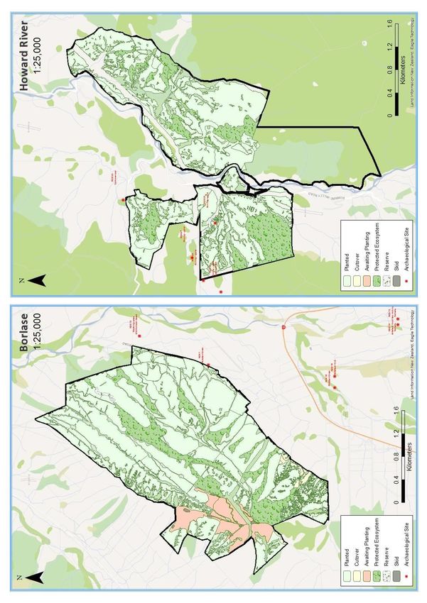
Map 2 – Borlase and Howard River’s Threatened Environment
Classifications
JUNE 2019 The Regulatory Environment Page 17FOREST MANAGEMENT PLAN FSCGS04
TASMAN DISTRICT COUNCIL FORESTS
Map 3 – Kingsland and Moturoa / Rabbit Island’s Threatened
Environment Classifications
JUNE 2019 The Regulatory Environment Page 18FOREST MANAGEMENT PLAN FSCGS04
TASMAN DISTRICT COUNCIL FORESTS
Map 4 – Sherry River and Tunnicliff’s Threatened Environment
Classifications
JUNE 2019 The Regulatory Environment Page 19FOREST MANAGEMENT PLAN FSCGS04
TASMAN DISTRICT COUNCIL FORESTS
Socio-economic profile and adjacent land
Forest history The forests have been acquired and developed over many years. Property
purchase since the 1990’s has been opportunistic by acquisitions of
uneconomic sheep farms with the intention to achieve a minimum stocked
area of around 3,000 hectares. Priority has been given to land adjacent to
existing holdings.
Borlase
Borlase was purchased to provide an alternative forest resource for the
County in the event that Moturoa / Rabbit Island forest was lost to the County
for production forestry. The forest was named after Jack Borlase, a Council
Chairman. The bulk of the forest was purchased in 1972 but since then two
further blocks have been added being the 160-hectare Moffat and the 104
hectare Quinney blocks acquired in 1992.
Howard
The Howard block, totalling 995 hectares, was purchased in 1993 from the
Marshall family. About 40 hectares (including the homestead) was sold
following purchase. Included with the purchase are two Forestry Right Joint
Venture blocks, one of 23 hectares and the other of 70 hectares. The Council
will receive a share of revenue at harvest. Management of these blocks is
carried out independently by the holder of the forestry right and neither of
these blocks is included in the certified area.
Kingsland
Kingsland Forest comprises the Waterworks Reserve Block, the Heslop Block
and the most recent acquisition, the Brown Block. The 72-hectare Waterworks
Reserve Block was acquired by the Council (the then Richmond Borough
Council) to provide a protected water catchment for the Richmond Borough. It
was bought by Council in 1923. The 54-hectare Heslop Block was bought by
Council in 1988. The 18-hectare Brown Block was purchased and planted in
1994. A further small area was bought from the Heslop family in 2013, near
the reservoir.
Moturoa / Rabbit Island
Moturoa / Rabbit Island is Crown Land which was vested to the Tasman
District Council (formerly the Waimea County council) in 1921 for plantation
purposes under the provisions of the Reserves and Other Land Disposal and
Public Bodies Empowering Act 1920. In 1921 the first plantings of radiata pine
took place, with afforestation coming under the Council Engineers
Department. The Order in Council of 22 August 1921 excluded some 143
hectares of Moturoa / Rabbit Island from use for plantation purposes. This
land area consisted mainly of a 5-chain wide strip of land along the northern,
western, and eastern coasts of the Island, along with a 15-chain strip along
part of the northern side of the Island which now includes the main public
domain area. The domain area has since been increased to 240 hectares.
Continued on next page...
JUNE 2019 The Regulatory Environment Page 20FOREST MANAGEMENT PLAN FSCGS04
TASMAN DISTRICT COUNCIL FORESTS
…continued
Sherry River
The Tasman District Council purchased 623 hectares of terraces, hill country,
pasture and reverting scrub land in the Sherry River area in November 1994.
The better terraces and the homestead have since been sold, as have an
additional 22 hectares of pasture which were sold in 2016. Included with the
original purchase was a Forestry Right Joint Venture block that is progressively
handed back to the Council, and currently the only remaining block comprises
7ha of Douglas-fir planted in 1982.
Tunnicliff
This block, legal title area 133 hectares, was purchased in 1971 from Henry
Tunnicliff. Included in the title area is approximately 20 hectares of native
bush. The first plantings took place in 1971-72 entirely in radiata pine. These
have all been harvested and re-planted predominantly in radiata pine with
some small areas of Douglas-fir and Cupressus species.
Current social The forests on the Council estate all fall within the Tasman region – one of
profile the least populated regions in New Zealand. Due to the size of the Council
forests in a regional context, all of the workers are employed by contractors
who also work for a number of other forestry companies and are not
dependent on the Council forests for full time employment.
Table 7: Key statistics as summarised from 2013 Census2 data
Census Category Tasman Region New Zealand
Ethnicity – European 93.1% 74.0%
Ethnicity – Māori 7.6% 14.9%
Formal Qualifications 76.7% 79.1%
Unemployment 4.0% 7.1%
Dominant Occupation Managers Professionals
Median Income $25,700 $28,500
Family with Children 38.8% 41.3%
Internet Access 75.9% 76.8%
Home Ownership 75.0% 64.8%
Agriculture, Forestry & Fishing 26.3% 5.7%
Combining data from the Atlas of Deprivation (Ministry of Health) and
average income from Statistics NZ, it is apparent that the Tasman region
fares reasonably well in terms of overall wealth, and distribution of
wealth throughout the district. Age and family statistics confirm the
higher number of families and elderly within the region than the
national average.
2
http://archive.stats.govt.nz/Census/2013-census/profile-and-summary-reports/quickstats-about-a-
place.aspx?request_value=14546&tabname=
JUNE 2019 The Regulatory Environment Page 21FOREST MANAGEMENT PLAN FSCGS04
TASMAN DISTRICT COUNCIL FORESTS
Associations with There are currently no direct ‘day to day’ associations with local Iwi;
Tangata Whenua however, where input is required for resource consents extensive
consultation is carried out. In the recent past, harvesting operations within
Moturoa / Rabbit Island have involved Tiakina te Taiao Ltd, a non-profit iwi
environmental agency that represents three of the nine iwi in the Whakatū
and Motueka rohe.
Te Kahui Mangai, the NZ government’s directory of Iwi and Maori
organisations, identify Iwi groups associated with a region by:
• Iwi recognised by the Crown in the Māori Fisheries Act 2004;
and
• Any other iwi/hapū groups that have been formally recognised
by the Crown for historic Treaty settlement purposes.
Most of these recognised iwi/hapū are represented by an Iwi authority for
the purposes of the Resource Management Act 1991. Maori groups
associated with the area containing the Council forest estate as recognised
by Te Kahui Mangai are:
• Ngāti Toa Rangatira
• Te Atiawa o Te Waka-a-Māui
• Ngāti Apa ki te Rā Tō
• Ngāti Kuia
• Ngāti Rārua
• Ngāti Koata
• Ngāti Tama ki Te Tau Ihu
• Ngāi Tahu
• Rangitāne o Wairau
Tenure & resource The land tenure is freehold with the exception of Moturoa / Rabbit Island
rights which was vested by the Crown by Order in Council in 1921 to the then
Waimea County Council. A search of the Maori Land Online website
(http://www.maorilandonline.govt.nz/gis/map/search.htm) returned no
results.
JUNE 2019 The Regulatory Environment Page 22FOREST MANAGEMENT PLAN FSCGS04
TASMAN DISTRICT COUNCIL FORESTS
Neighbours Neighbours to the forest estate boundaries have a special interest in the
management of the forest. Activities within the forest may positively or
negatively impact upon their quality of life or businesses in a number of
ways, while inappropriately managed operations could create risks of
adverse health, safety and environmental hazards. Neighbours may use
the forests for recreational purposes or place reliance on the forests for
provision of water quality or quantity services. Boundary issues such as
weed and pest control, access and boundary alignment issues may also
involve neighbours.
Appendix 2 lists the forest neighbours and their primary activities, while
Appendix 3 provides maps showing the locations of those neighbours in
relation to the forests.. Some or all of these parties should be consulted
when operations are proposed in forest areas adjacent to their
boundaries.
JUNE 2019 The Regulatory Environment Page 23FOREST MANAGEMENT PLAN FSCGS04
TASMAN DISTRICT COUNCIL FORESTS
REGULATORY ENVIRONMENT AND RISK
MANAGEMENT
1. The Regulatory Environment
Regulatory Forestry operations throughout New Zealand are undertaken within the
considerations context of a regulatory framework that aims to ensure wider economic,
social and environmental goals are achieved for the populace as a whole.
Failure to meet regulatory requirements is a key business risk that must be
managed. The following section summarise key regulatory requirements
and risk management controls exercised over forestry operations in the
forest.
Health and Leadership, a constant focus on health and safety, and the strong message
Safety at Work that safety rates as the number one priority ahead of any other business
Act 2015 driver are all highly important for PF Olsen management. The company
also takes the following steps to ensure worker health and safety:
• Contractor selection process including emphasis on:
– safety systems and track record;
– worker skills and training; and
– equipment types and standard.
• Work planning.
• Contractor induction.
• Monitoring, including random and reasonable cause drug testing,
safe work practices and PPE.
• Incident investigation and reporting, including investing in software,
training and processes development to enable good transparency on
lag and lead indicators.
• Regular reporting to and interaction with the Client on matters
related to safety.
• Regular (annual) review and update of the critical risks as identified
in PF Olsen data sets and from Industry indicators. Such a review
shall focus on incidents that have caused harm and/or loss, any
known cause factors and mitigations and revised controls.
Resource The Council estate is subject to the provisions of the Resource
Management Act Management Act (RMA) 1991. The RMA sets up a resource management
system that promotes the sustainable management of natural and physical
resources and is now the principal statute for the management of land,
water, soil and other resources in New Zealand. Table 8 lists the
organisations relevant to the Council estate forests.
Continued on next page...
JUNE 2019 The Regulatory Environment Page 24FOREST MANAGEMENT PLAN FSCGS04
TASMAN DISTRICT COUNCIL FORESTS
…continued
Table 8: Regional and District Councils under Council Estate Forests
Regional Councils 3 District Councils 4
Tasman District Council Tasman District Council
Under the RMA, each Council has its own planning documents and
associated rules that have been developed through public process. Any
forestry operations must comply with the rules relevant to the Council
area in which the operations are to take place. The contact details for the
relevant councils can be seen in Appendix 4.
National Coming into law on 1 May 2018, the NES-PF is a whole new rule hierarchy
Environmental that applies the same rule set uniformly across most forestry operations in
Standard for all parts of New Zealand. Operations will come under the legal force of this
Plantation RMA instrument, though local Councils will retain the ability to regulate
Forestry (NES-PF) specific areas outside the NES-PF, e.g. Significant Natural Areas,
Outstanding Landscapes, giving effect to the Coastal Policy Statement etc.
The underpinning the structure of the NES-PF is a rule hierarchy linked to
the erosion susceptibility of the lands upon which forestry operations are
to be conducted.
Work commissioned by the Ministry of Primary Industries led to the
creation of a national spatial map, the ‘Erosion Susceptibility Layer’ (ESC)
that classifies all of New Zealand into a series of four classes of erosion
susceptibility from low (green) to very high (red).
The stringency of the rule’s hierarchy, i.e. whether consents are needed
and the degree to which Councils can apply discretion to the conditions
attached to a consent, is then tied closely to the recognised erosion
susceptibility of the lands involved and the risks created by the operations.
In the case of the council estate, Table 8 below indicates the proportion of
the forest by the respective ESC classes.
In broad terms, harvesting, roading (earthworks) and new afforestation
operations will need consents in the red zone. Earthworks will need
consents in orange, and in the green and yellow zones most operations will
be permitted subject to conditions. The coverage of the erosion classes
within the estate are illustrated in Maps 5 to 7 and in Table 9.
Continued on next page...
3
Regional Councils responsible for soil conservation and water and air quality issues
4
District Councils responsible for land use and biodiversity issues
JUNE 2019 The Regulatory Environment Page 25FOREST MANAGEMENT PLAN FSCGS04
TASMAN DISTRICT COUNCIL FORESTS
…continued
Table 9: ESC Classes (Erosion Risk) for Council Estate Forests
Forest Low Moderate High Water Shingle Total
162.2 ha 810.0 ha 972.2 ha
Borlase
16.7% 83.3% 100%
61.5 ha 651.9 ha 248.4 ha 1.3 ha 1.2 ha 964.2 ha
Howard River
6.4% 67.6% 25.8% 0.1% 0.1% 100%
157.9 ha 157.9 ha
Kingsland
100% 100%
Moturoa / 1,216.7 ha 1,216.7 ha
Rabbit Island 100% 100%
176.4 ha 260.7 ha 120.3 ha 557.4 ha
Sherry River
31.6% 46.8% 21.6% 100%
129.5 ha 129.5 ha
Tunnicliff
100% 100%
Total 1,746.3 ha 1,880.4 ha 368.7 ha 1.3 ha 1.2 ha 3,997.8 ha
JUNE 2019 The Regulatory Environment Page 26FOREST MANAGEMENT PLAN FSCGS04
TASMAN DISTRICT COUNCIL FORESTS
Map 5 – Erosion Susceptibility Classes in Borlase and Howard River
Forests
JUNE 2019 The Regulatory Environment Page 27FOREST MANAGEMENT PLAN FSCGS04
TASMAN DISTRICT COUNCIL FORESTS
Map 6 - Erosion Susceptibility Classes in Kingsland and Moturoa /
Rabbit Island Forests
JUNE 2019 The Regulatory Environment Page 28FOREST MANAGEMENT PLAN FSCGS04
TASMAN DISTRICT COUNCIL FORESTS
Map 7 - Erosion Susceptibility Classes in Sherry River and Tunnicliff
Forests
JUNE 2019 The Regulatory Environment Page 29FOREST MANAGEMENT PLAN FSCGS04
TASMAN DISTRICT COUNCIL FORESTS
Heritage New Under the Heritage New Zealand Pouhere Taonga Act 2014 it is the
Zealand Pouhere landowner’s responsibility to identify any historic sites on their land prior
Taonga Act 2014 to undertaking any work which may disturb or destroy such sites. Records
of archaeological and historical places are maintained in the NZ
Archaeological Association (NZAA) Site Recording Scheme
http://www.archsite.org.nz/.
If a site is found or suspected on any block, protocols specified in
PF Olsen’s EMS, and any others specifically developed in conjunction with
Heritage New Zealand (HNZ), archaeologists and Iwi or other stakeholders,
will be observed and the necessary Archaeological Authorities obtained
with HNZ, and if necessary the local Territorial Authority.
These responses may include, but are not limited to:
• Map and ground surveys to identify, mark and protect known
heritage sites.
• Iwi consultation and surveys for unknown sites.
• Archaeological Authorities to modify sites if required.
Accidental Discovery Protocols to stop work and engage experts if sites are
discovered during operations.
Consents & There are two current resource consent that applies to the Council forests
authorities held at present, as below.
Table 10: Resource consents applicable to the Council forest estate
Consent ID Expiry Forest Details
Howard Construction of a single-span
RM190636 31/05/2054
River bridge on the Howard River
Moturoa / Recorded and unrecorded
2016/1211 25/07/2021
Rabbit Island sites
The Emissions Forests in New Zealand are governed by rules related to New Zealand’s
Trading Scheme Kyoto commitments to reduce the nation’s carbon footprint and
contribution to associated climate change.
The Council forests contain 1,964.3 hectares of forest that was existing
forest as at 31st December 1989. At the time of harvest, these stands will
be subject to a deforestation tax equivalent to the tonnes of CO2 projected
to be released from decomposition of the forest at a unit financial value
determined by the internationally traded emission units. This tax is
payable if the forest is not replanted or, if left to regenerate naturally,
does not achieve the regulated heights and stocking densities.
Continued on next page...
JUNE 2019 The Regulatory Environment Page 30FOREST MANAGEMENT PLAN FSCGS04
TASMAN DISTRICT COUNCIL FORESTS
…continued A total of 1,065.7 hectares was planted on ‘Kyoto compliant’ land that was
vacant as at 31st December 1989 and have been registered to participate in
the NZ Emissions Trading Scheme. These areas are subject to the accrual of
emissions credits and liabilities under that scheme.
Other relevant There are numerous other statutes and regulations that impact on forest
legalisation operations. Forest owners can be held liable for breaches of these Acts
and may be held responsible for damage to third party property.
Management processes seek to manage and minimise these risks.
Other relevant legislation is listed in Appendix 5.
JUNE 2019 The Regulatory Environment Page 31FOREST MANAGEMENT PLAN FSCGS04
TASMAN DISTRICT COUNCIL FORESTS
2. Commercial Risk Management
Market access It is a major focus of the Property Manager to ensure contracted products
retention are delivered on time and in specification to ensure Tasman District
Council retains credible access to its markets.
Tasman District Council maintains independent third party environmental
certification for its estate under Forest Stewardship Council certification
(FSC). PF Olsen Ltd acting under the instruction of its client will be
responsible for the excecution and maintenance of the required FSC
certification elements of which this management plan forms an important
component.
Forest insurance TDC holds its own forest crop insurance. This includes cover for wind and
fire which are the main forest risks.
Log customer There have been a number of NZ sawmills fail in recent years leaving log
credit risk customers unpaid for the last month’s deliveries. The PF Olsen Investment
Manager manages customer credit risk exposure and mitigation measures
for export markets while PF Olsen manages these risks for domestic log
customers.
PF Olsen also provides a Payment Protection insurance at a cost of 0.16%
of log sales revenue. TDC has opted to not use this insurance but can opt in
at any time.
Infrastructure The Council estate is traversed by several powerline utilities. Risks
damage or around these are managed by:
service • Identification on maps and on the ground any utilities at planning
disruption stage.
• Early engagement with utility owner to plan operations to
minimise risks.
• Operational execution of agreed plans with parties specifically
qualified for the tasks involved when working close to utilities.
Pests and Pests and diseases are managed according to any statutory obligations and
diseases best practices as identified by scientific research and past experience, with
the type and intensity of treatment (if any) subject to what is at risk and
the age of trees (see Section 14).
JUNE 2019 Commercial Risk Management Page 32FOREST MANAGEMENT PLAN FSCGS04
TASMAN DISTRICT COUNCIL FORESTS
3. Environmental Risk Management
Environmental Environmental risk is managed by PF Olsen as appointed property
risk manager, through a cascade framework from high level ‘intent’
determined by the Forestry Rights owner, through PF Olsen’s own
environmental policies, thence through defined and documented
processes constituting an Environmental Management System (EMS),
supported by monitoring and reporting. PF Olsen’s policies and Tasman
District Council’s business objectives are considered to be well in
alignment.
Environmental PF Olsen Limited is committed to:
policy • Sustainable forest and land management;
• Promoting high environmental performance standards that recognise the
input of the community in which we operate;
• Supporting an environment of continuous improvement in environmental
performance;
• Obtaining and retaining independent 3rd party forest certification in
conformance with the Principles and Criteria of the Forest Stewardship
Council and / or the Programme for Endorsement of Forest Certification as
specified by forest owning clients, or in any case ISO:14001 Environmental
Management Systems.
In order to achieve these commitments PF Olsen (and PF Olsen Certification Scheme
Members) will undertake the following:
• Where applicable to a particular forest, comply with the presiding Certification
Standards as set out in any agreements between the forest owners and PF Olsen.
• Planning of operations to avoid, mitigate or remedy degradation of ecological,
heritage and amenity values;
• Compliance with all relevant legislation and where appropriate exceed
environmental statutory requirements;
• Training for all employees and contractors to ensure an understanding of
certification member’s commitments to high standards of environmental
performance, their responsibilities under the environmental legislation and to
assist the implementation of sound environmental practices;
• Monitoring environmental and socio-economic research and international
agreements that may improve PF Olsen environmental and certification
performance;
• Regular environmental performance audits of operations;
• Support for environmental research;
• Undertake forest management in accordance with the principles and ethics of the
NZ Forest Accord the Principles for Commercial Plantation Forest Management
in NZ, and other relevant agreements, conventions and accords.
• Promotion of the prevention of waste and pollution; and efficient use of energy;
• Due regard for the well-being of the community.
JUNE 2019 Environmental Risk Management Page 33FOREST MANAGEMENT PLAN FSCGS04
TASMAN DISTRICT COUNCIL FORESTS
Objectives, PF Olsen’s objectives, targets and monitoring categorised across five key
targets and aspects of the business:
monitoring 1. Economic
2. Legal
3. Social
4. Health & safety
5. Environment
A systematic management approach ensures these objectives and targets
remain the cornerstone of PF Olsen’s business, backstopped by monitoring
processes that form a regular review of practices.
EMS framework The Environmental Management System (EMS) is an integrated set of
cloud based, defined and documented policies, processes and activities
that govern the physical implementation of forest management activities.
The EMS applies a systematic approach certified to ISO:14001 standards to
ensure that prevention of adverse and harmful impacts is effective.
The framework is reviewed annually with the input of an Environmental
Management Group (EMG).
Environmental As a member of the New Zealand Forest Owners Association, all
Code of Practice operations carried out on the properties should be undertaken in
conformance to the NZ Forest Owners Association ‘New Zealand
Environmental Code of Practice for Plantation Forestry’. This publicly
available document sets out guidelines that underpin the requirements for
sound and practical environmental management.
Forest Road As a member of the New Zealand Forest Owners Association, roading and
Engineering engineering techniques employed within the forests should conform to the
Manual industry best practice as outlined in the New Zealand Forest Owners
Association publication, ‘NZ Forest Road Engineering Manual’, published
2012.
Assessment of Environmental risks arising from forest operations are assessed and
environmental managed on a site-by-site basis prior to execution. The relative probability
risks and magnitude of adverse effect attributable to any particular operation
on any particular site is highly variable.
Earthworks, planting and harvesting have the potential to destroy or
damage any historic places that may be present. Native vegetation has the
potential to be killed by harvesting into the reserve or spraying of the
Continued on next page...
JUNE 2019 Environmental Risk Management Page 34FOREST MANAGEMENT PLAN FSCGS04
TASMAN DISTRICT COUNCIL FORESTS
…continued
reserve. Water quality can be negatively affected by sediment runoff
because of harvesting, stream crossing and earthwork operations. In
addition, the entry of oil and fuel and fertilisers will reduce the quality of
water.
The level of potential risk has been evaluated in the matrix as high ‘H’,
medium ‘M’ or low ‘L’, or not applicable ‘NA’ and is thus indicative of the
level of care that might need to be applied to ensure the potential for
adverse effects is minimised (Table 11).
Table 11: Risk assessment for key aspects involved in forest management activities
Soil Conservation & Quality Environmental Values / Issues matrix
Erosion& Sediment Control
Historical &Cultural Values
Landscape &Visual Values
Threatened Species
Forestry Operational
Native Vegetation
Recreation Values
Activities
Native Wildlife
Public Utilities
Water Quality
Aquatic Life
Neighbours
Air Quality
Harvesting H M M L M L L L M H L L H
Earthworks H H M L H L L L H L L L H
Slash Management H M L L M L L L L L L L L
Stream Crossings H H L L H L L L L L L L L
Mechanical Land
NA NA NA NA NA NA NA NA NA NA NA NA H
Preparation
Burning L L L H L L L L H H L H NA
Planting L L L L L L L L L L L L L
Tending L L L L L L L L L L L L L
Fertiliser Application L H L L H L L L L L L L M
Agrichemical Use L H L L H L H L L H H H H
Oil & Fuel Management L H L L H L L L L H L L L
Waste Management L L L L L H L L L L L L L
Forest Protection L L L L L L L L L L L L L
Hazardous Hazardous substances are any substances, which may cause adverse
substances environmental impacts and/or injury or health problems if incorrectly
management handled or used.
The hazardous materials which may be used within the Council estate are:
• Pesticides
– Herbicides: for commercial and ecological weeds;
Continued on next page...
JUNE 2019 Environmental Risk Management Page 35FOREST MANAGEMENT PLAN FSCGS04
TASMAN DISTRICT COUNCIL FORESTS
…continued
– Fungicides: for forest fungal disease control; and
– Vertebrate or Invertebrate Toxins: used for control of pest
mammals (e.g. hares and possum or wasps).
• Fuels and oils
• Fire retardants: (only ever used if there is a fire)
• Surfactants: to increase herbicide efficacy
Transportation, storage and labelling of these hazardous materials must all
comply with the provisions of legislative controls under the Environmental
Protection Agency (EPA) and the NZS 8409:2004 Management of
Agrichemicals code of practice.
During actual usage, the highest risks are associated with chemical
trespass or bulk fuel spillages. These risks are managed by:
• Neighbour consultation over planned spray operations.
• Careful planning and timing of any aerial operations having regard to
wind and spray drift.
• Unsprayed buffer strips on neighbour boundaries and riparian or
other protected reserves.
• GPS flight path control and records.
• Monitoring and recording of weather conditions during the
operation, including using smoke bombs and photos/video.
• Moving contractors into the use of double skinned bulk fuel storage
tanks as the preferred method of containment for all larger capacity
tanks.
• Tracking of all active ingredient usage within the estate.
Risk management includes active involvement in and review of
technologies and research into alternative methods for the control of
weeds, pests and diseases where these are effective and efficient.
Fuel use is directly related to the machinery used in forestry operations
and the market locations. Using modern efficient machine technology is
still the primary area where efficiency gains can be made. There is a steady
programme to transfer chain bar oils to vegetable based low toxicity oils.
Highly hazardous There are five agrichemicals that have been classified ‘highly hazardous’
chemicals (HH) by FSC that are used in forestry and conservation operations within
PF Olsen group certified forests. All these five have recently been added to
FSC’s HH list.
Continued on next page...
JUNE 2019 Environmental Risk Management Page 36You can also read