LOCAL AREA PLAN 2021-2027 - NATURA IMPACT REPORT APPROPRIATE ASSESSMENT DRAFT ATHY
←
→
Page content transcription
If your browser does not render page correctly, please read the page content below

NATURA IMPACT REPORT
                         IN SUPPORT OF THE

              APPROPRIATE ASSESSMENT

                                 FOR THE

                DRAFT ATHY
        LOCAL AREA PLAN 2021-2027

for:   Kildare County Council
       Áras Chill Dara
       Devoy Park
       Naas
       County Kildare

by:    CAAS Ltd.
       1st Floor
       24-26 Ormond Quay Upper
       Dublin 7

                          DECEMBER 2020
Appropriate Assessment of the Draft Athy Local Area Plan 2021-2027

                                           Table of Contents

                Introduction ...................................................................................................... 1
 1.1 Background .......................................................................................................................1
 1.2 Legislative Context .............................................................................................................1
 1.3 Approach...........................................................................................................................1
                Description of the Plan ..................................................................................... 3
                Screening for Appropriate Assessment............................................................. 5
 3.1 Introduction.......................................................................................................................5
 3.2 Identification of Relevant European Sites .............................................................................5
 3.3 Assessment Criteria and Screening ......................................................................................8
 3.4 Other Plans and Programmes ............................................................................................ 10
 3.5 AA Screening Conclusion................................................................................................... 10
                Stage 2 Appropriate Assessment .................................................................... 12
 4.1 Introduction..................................................................................................................... 12
 4.2 Characterisation of European sites Potentially Affected ........................................................ 12
 4.3 Identifying and Characterising Potential Significant Effects ................................................... 12
                Mitigation Measures........................................................................................ 19
                Conclusion ....................................................................................................... 23

Appendix I        Background information on European sites
Appendix II Relationship with Other Plans and Programmes

 CAAS for Kildare County Council                                                                                                     i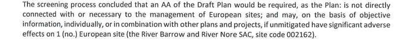
Appropriate Assessment of the Draft Athy Local Area Plan 2021-2027

                                             List of Tables
Table 3.1 Screening of European sites within 15 km of the Plan area ...............................................9
Table 4.1 Characterisation of Potential Effects arising from the Plan .............................................. 18
Table 5.1 Measures most relevant to the protection of European sites ........................................... 20

                                            List of Figures
Figure 3.1 European sites within 15 km of the Plan area.................................................................7
Figure 3.2 Ancillary AA Screening Determination .......................................................................... 11

  CAAS for Kildare County Council                                                                                        ii
Appropriate Assessment of the Draft Athy Local Area Plan 2021-2027

                             Introduction
1.1 Background
This Natura Impact Report (NIR) has been prepared in support of the Appropriate Assessment (AA) of
the Draft Athy Local Area Plan 2021-2027 in accordance with the requirements of Article 6(3) of
Council Directive 92/43/EEC on the Conservation of Natural Habitats and of Wild Fauna and Flora (as
amended) (hereafter referred to as the “Habitats Directive”).

This report is part of the ongoing AA process that is being undertaken alongside the preparation of
the Plan. It will be considered, alongside other documentation prepared as part of this process, when
Kildare County Council finalises the AA at adoption of the Plan.

1.2 Legislative Context
The Habitats Directive provides legal protection for habitats and species of European importance. The
overall aim of the Habitats Directive is to maintain or restore the “favourable conservation status” of
habitats and species of European Community Interest. These habitats and species are listed in the
Habitats1 and Birds Directives2 with Special Areas of Conservation (SACs) and Special Protection Areas
(SPAs) designated respectively to afford protection to the most valuable and threatened of them.
These two designations are collectively known as European sites and Natura 2000 sites.

AA is required by the Habitats Directive, as transposed into Irish legislation by the European
Communities (Birds and Natural Habitats) Regulations 2011 (as amended) and the Planning and
Development Act (as amended). AA is an assessment of the potential for adverse or negative effects
of a plan or project, in combination with other plans or projects, on the conservation objectives of a
European site.

1.3 Approach
The AA is based on best scientific knowledge and has utilised ecological and hydrological expertise. In
addition, a detailed online review of published scientific literature and ‘grey’ literature was conducted.
This included a detailed review of the National Parks and Wildlife (NPWS) website including mapping
and available reports for relevant sites and in particular sensitive qualifying interests/special
conservation interests described and their conservation objectives.

The ecological desktop study completed for the AA of the Plan comprised the following elements:

           •        Identification of European sites within 15km of the Plan boundary with identification
                    of potential pathways links for specific sites (if relevant) greater than 15km from the
                    Plan boundary;
           •        Review of the NPWS site synopsis and conservation objectives for European sites
                    with identification of potential pathways from the Plan area; and
           •        Examination of available information on protected species.

There are four main stages in the AA process as follow:

           Stage One: Screening
           The process that identifies the likely impacts upon a European site of a project or plan, either
           alone or in combination with other projects or plans and considers whether these impacts are
           likely to be significant.

1   Directive 92/43/EEC on the conservation of natural habitats and of wild fauna and flora
2   Directive 2009/147/EC on the conservation of wild birds

CAAS for Kildare County Council                                                                          1
Appropriate Assessment of the Draft Athy Local Area Plan 2021-2027

        Stage Two: Appropriate Assessment
        The consideration of the impact on the integrity of the European site of the project or plan,
        either alone or in combination with other projects or plans, with respect to the site’s structure
        and function and its conservation objectives. Additionally, where there are adverse impacts,
        an assessment of the potential mitigation of those impacts. If adequate mitigation is
        proposed to ensure no significant adverse impacts on European sites, then the process may
        end at this stage. However, if the likelihood of significant impacts remains, then the process
        must proceed to Stage Three.

        Stage Three: Assessment of Alternative Solutions
        The process that examines alternative ways of achieving the objectives of the project or plan
        that avoids adverse impacts on the integrity of the European site.

        Stage Four: Assessment where no alternative solutions exist and where adverse
        impacts remain
        An assessment of compensatory measures where, in the light of an assessment of imperative
        reasons of overriding public interest (IROPI), it is deemed that the project or plan should
        proceed.

Ecological impact assessment of potential effects on European sites is conducted following a standard
source (e.g. pollutant run-off from proposed works) – pathway (e.g. groundwater connecting to
nearby qualifying wetland habitats) - receptor (e.g. qualifying aquatic habitats and species of
European sites) model, where, in order for an effect to be established all three elements of this
mechanism must be in place. The absence or removal of one of the elements of the mechanism is
sufficient to conclude that a potential effect is not of any relevance or significance.

In the interest of this report, receptors are the ecological features that are known to be utilised by the
qualifying interests or special conservation interests of a European site. A source is any identifiable
element of the Plan provision that is known to interact with ecological processes. The pathways are
any connections or links between the source and the receptor. This report provides information on
whether direct, indirect and cumulative adverse effects could arise from the Plan.

This report has been prepared taking into account legislation including the aforementioned legislation
and guidance including the following:

        •        Appropriate Assessment of Plans and Projects in Ireland. Guidance for Planning
                 Authorities, Department of the Environment, Heritage and Local Government, 2009;
        •        "Commission Notice: Managing Natura 2000 sites - The provisions of Article 6 of the
                 'Habitats' Directive 92/43/EEC", European Commission 2018;
        •        “Assessment of plans and projects significantly affecting Natura 2000 sites:
                 Methodological guidance on the provisions of Article 6(3) and (4) of the Habitats
                 Directive 92/43/EEC”, European Commission Environment DG, 2002; and
        •        “Managing Natura 2000 sites: The Provisions of Article 6 of the Habitats Directive
                 92/43/EEC”, European Commission, 2000.

CAAS for Kildare County Council                                                                        2
Appropriate Assessment of the Draft Athy Local Area Plan 2021-2027
Description of the Plan
Kildare County Council intends make a new Local Area Plan (LAP) for Athy under Section 20 of the
Planning and Development Act 2000 (as amended). The Plan will set out an overall strategy for the
proper planning and sustainable development over the years 2021-2027.
LAPs are required to be consistent with the policies and objectives of the County Development Plan
and its Core Strategy, as well as the National Planning Framework and Regional Spatial Economic
Strategies.
The Draft LAP should be read in conjunction with the Kildare County Development Plan 2017-2023
(as varied), which sets out the overarching development strategy for the county. Where any
provisions of the LAP conflict with the provisions of the County Development Plan, the provisions of
the LAP shall cease to have effect.
The Draft Plan comprises a Written Statement (including written policies and objectives) and
associated maps (including land use zoning). The Plan will contribute towards the proper planning
and sustainable development of the area.
Chapters 1 to 3 of the Plan (Introduction and Context; Spatial Planning Context and Vision for Athy;
Compliance with the Kildare County Core Strategy) provide an overview of the LAP. Chapters 4 to 11
cover the specific subject areas as follows:
Homes and Communities
Urban Centre and Retailing
Economic Development, Enterprise and Tourism
Movement and Transport
Built Heritage and Archaeology
Natural Heritage, Green Infrastructure and Strategic Open Space
Infrastructure and Environmental Services
Implementation
Appendices include the Athy Urban Regeneration Framework, this SEA Environmental Report, an
Appropriate Assessment Natura Impact Report and a Strategic Flood Risk Assessment.
The Plan’s Vision Statement is:
“ To successfully fulfil Athy’s role as a self-sustaining growth town by embracing the
transition to a low carbon and climate resilient model of development which seeks to utilise
and invest in the town’s existing economic, social and environmental assets to generate
sustainable economic development and job creation, thereby enhancing its status as the main
economic and services centre of South Kildare.
The vision for the Local Area Plan will ensure that growth planned for the town over the life
of the Plan and beyond occurs in a sustainable and sequential manner, characterised by a
compact, consolidated and permeable pattern of development linked by sustainable modes of
transport including a robust network of pedestrian and cycle routes, providing a high level of
connectivity; facilitating and enabling the creation of a healthy, safe and age-friendly
community.
In essence, by 2027 a series of concerted steps will have been taken to ‘future proof’ Athy
and create a more sustainable inclusive settlement centred around a regenerated and vibrant
town centre providing important retail and commercial services and hosting an improved
tourist offer. The town will not only be more resilient to the effects of climate change but will
also have adapted to the needs of a growing and aging population, through the development
of integrated communities, served by an enhanced level of social infrastructure and an
expanded green infrastructure network.”
CAAS for Kildare County Council 3
Appropriate Assessment of the Draft Athy Local Area Plan 2021-2027

The Draft Plan sits within a hierarchy of strategic actions such as plans and programmes and is
subject to a number of high-level environmental protection policies and objectives with which it must
comply (including those detailed throughout this report). The Plan may, in turn, guide lower-level
strategic actions. In this regard, Appendix II of this report includes statutory provisions, plans,
policies and strategies that set the context within which the Plan is framed and which have influenced
the provisions of the Plan.

The Plan is accompanied by a land use zoning map that directs land uses towards compatible
locations in the town and surrounding area.

CAAS for Kildare County Council                                                                    4
Appropriate Assessment of the Draft Athy Local Area Plan 2021-2027
Screening for Appropriate Assessment
3.1 Introduction
This stage of the process identifies any potential significant affects to European sites from a project
or plan, either alone or in combination with other projects or plans.
An important element of the AA process is the identification of the “‘conservation objectives”,
“Qualifying Interests” (QIs) and/ or “Special Conservation Interests” (SCIs) of European sites
requiring assessment. QIs are the habitat features and species listed in Annexes I and II of the
Habitats Directive for which each European site has been designated and afforded protection. SCIs
are wetland habitats and bird species listed within Annexes I and II of the Birds Directive. It is also
vital that the threats to the ecological / environmental conditions that are required to support QIs and
SCIs are considered as part of the assessment.
The following NPWS Generic Conservation Objectives have been considered in the screening:
For SACs, to maintain or restore the favourable conservation condition of the Annex I
habitat(s) and/or the Annex II species for which the SAC has been selected.
Where available, Site-Specific Conservation Objectives (SSCOs) designed to define favourable
conservation status for a particular habitat3 or species4 at that site have been considered.
3.2 Identification of Relevant European Sites
The Department of the Environment (2009) Guidance on AA recommends a 15 km buffer zone to be
considered. A review of all sites within this zone has allowed a determination to be made that in the
absence of significant hydrological links the characteristics of the Plan will not impose effects beyond
the 15 km buffer. It is noted that the River Suir SAC is situated downstream of the Plan area;
however, it is not required to be consider as part of the AA Screening process as there is no potential
for effects to occur; the River Barrow joins the River Suir over 100 km downstream from Athy where
there is a significant mixing between these two rivers, other water courses and the sea.
Details of European sites that occur within 15 km of the Plan is listed in Table 3.1. European sites and
EPA Rivers and Catchments are also mapped in Figure 3.1 overleaf. Information on QIs, SCIs and
site-specific vulnerabilities and sensitivities (see Appendix I) and background information (such as
that within Ireland’s Article 17 Report to the European Commission, site synopses and Natura 2000
standard data forms) has been considered by both the AA screening assessment (provided under this
section) and Stage 2 AA (provided under Section 4). Conservation objectives that have been
considered by the assessment are included in the following NPWS/ Department of Culture, Heritage
and the Gaeltacht documents:
NPWS (2011) Conservation Objectives for River Barrow and River Nore SAC
[IE0002162] Version 1.
NPWS (2018) Conservation Objectives for Ballyprior Grassland SAC [IE0002256]
Version 6.
3 Favourable conservation status of a habitat is achieved when: its natural range, and area it covers within that
range, are stable or increasing; the specific structure and functions which are necessary for its long-term
maintenance exist and are likely to continue to exist for the foreseeable future; and the conservation status of its
typical species is favourable.
4 The favourable conservation status of a species is achieved when: population dynamics data on the species
concerned indicate that it is maintaining itself on a long-term basis as a viable component of its natural habitats;
the natural range of the species is neither being reduced nor is likely to be reduced for the foreseeable future;
and there is, and will probably continue to be, a sufficiently large habitat to maintain its populations on a long-
term basis.
CAAS for Kildare County Council 5
Appropriate Assessment of the Draft Athy Local Area Plan 2021-2027

The assessment considers available conservation objectives. Since conservation objectives focus on
maintaining the favourable conservation condition of the QIs/SCIs of each site, the screening process
concentrated on assessing the potential effects of the Plan against the QIs/SCIs of each site. The
conservation objectives for each site were consulted throughout the assessment process.

CAAS for Kildare County Council                                                                    6
Appropriate Assessment of the Draft Athy Local Area Plan 2021-2027

Figure 3.1 European sites within 15 km of the Plan area5

5 Source: NPWS (datasets downloaded December 2020)

CAAS for Kildare County Council                                                                                    7
Appropriate Assessment of the Draft Athy Local Area Plan 2021-2027
3.3 Assessment Criteria and Screening
3.3.1 Is the Plan Necessary to the Management of European Sites?
The overarching objective of the Plan is not the nature conservation management of the sites, but the
coordinated planning and ongoing development of Athy. Therefore, the Plan is not considered to be
directly connected with or necessary to the management of European sites.
3.3.2 Elements of the Draft Plan with Potential to Give Rise to Effects
The Plan provides a framework for the sustainable development of Athy. Plan elements that could
potentially affect the integrity of European sites include:
Provisions for sectors such as climate action, urbanisation including residential and economic
development, streetscape works, community facilities, transport, green infrastructure, energy,
environmental infrastructure, recreation and tourism, which introduce sources for effects
through construction phase such as habitat destruction, light pollution, hydrological
interactions and disturbance effects; and
Loading pressures from the operational phase of developments – these sources could result
in habitat loss, disturbance effects, interactions with water quality and habitat fragmentation.
The elements of the Draft Plan with the highest potential to give rise to the effects indicated above
are generally associated with construction phase elements of the implementation of the Plan. The
operational phase elements of the Plan are generally consistent with the existing condition of the
area, however these will also need to be carefully considered. All policies and objectives are
considered in this assessment with respect to the ecological integrity of each of the European sites
identified. Considering the sensitivities/vulnerabilities of the QIs and SCIs in relation to all potential
sources for effects and potential pathways for such effects. Where sources and pathways for effects
are identified potential effects will be assessed in relation to the SSCOs.
3.3.3 Screening of Sites
Table 3.1 examines whether there is potential for effects on European sites considering information
provided above, including Appendix I. Sites are screened based on one or a combination of the
following criteria:
The existence of potential for pathways for significant effects, such as hydrological links Plan
proposals and the site to be screened;
The distance of the relevant site from the Plan boundary; and
The existence of a link between identified threats or vulnerabilities at a site to potential
impacts that may arise from the Plan.
CAAS for Kildare County Council 8Appropriate Assessment of the Draft Athy Local Area Plan 2021-2027
Table 3.1 Screening of European sites within 15 km of the Plan area
Site Code Site Name Distance Qualifying Feature Potential Effects Pathway Potential for
(km) (Qualifying Interest and Special Conservation Interests) (refer also to Sections 3.3.2 and 3.3.3 above) for In-
Significant Combination
Effects Effects
002162 River Barrow 0 European dry heaths [4030], Atlantic salmon (Salmo salar) [1106], The Plan provides a framework for land use development and activities with Yes Yes
and River Nore Otter (Lutra lutra) [1355], Estuaries [1130], Hydrophilous tall herb potential for construction and operation source effects throughout the town.
SAC fringe communities of plains and of the montane to alpine levels As this site is within the town Plan boundary, there are pathways for potential
[6430], Atlantic salt meadows (Atlantic salt meadows (Glauco- direct effects to the ecological integrity of the site and consideration at Stage
Puccinellietalia maritimae)) [1330], Desmoulin`s whorl snail (Vertigo 2 AA is required.
moulinsiana) [1016], River lamprey (Lampetra fluviatilis) [1099],
Western acidic oak woodland (Old sessile oak woods with Ilex and
Blechnum in the British Isles) [91A0], Freshwater pearl mussel
(Margaritifera margaritifera) [1029], Brook lamprey (Lampetra
planeri) [1096], Mudflats and sandflats not covered by seawater at
low tide [1140], Twaite shad (Alosa fallax) [1103], Petrifying springs
with tufa formation (Cratoneurion) [7220], Water courses of plain to
montane levels with the Ranunculion fluitantis and Callitricho-
Batrachion vegetation [3260], Sea lamprey (Petromyzon marinus)
[1095], White-clawed (or Atlantic stream) crayfish
(Austropotamobius pallipes) [1092], Killarney fern (Trichomanes
speciosum) [1421], Reefs [1170], Salicornia and other annuals
colonizing mud and sand [1310]
002256 Ballyprior 10.9 Semi-natural dry grasslands and scrubland facies on calcareous The Plan area is hydrologically isolated from this site. There are no provisions No No
Grassland SAC substrates (Festuco-Brometalia) (* important orchid sites) [6210] in the plan that introduce any sources for effects to the land use of the SAC.
As there are no sources with pathways for effects, no further assessment is
required.
CAAS for Kildare County Council 9Appropriate Assessment of the Draft Athy Local Area Plan 2021-2027
3.4 Other Plans and Programmes
Article 6(3) of the Habitats Directive requires an assessment of a plan or project to consider other
plans or programmes that might, in combination with the plan or project, have the potential to
adversely affect European sites. Appendix II outlines a selection of plans or projects that may interact
with the Plan to cause in-combination effects to European sites - these plans and programmes were
considered throughout the assessment.
All projects within the Draft LAP area and receiving environment will be considered in combination
with any and all lower tiers projects that may arise due to the implementation of the Plan. Given the
uncertainties that exist with regard to the scale and location of developments facilitated by the Draft
Plan, it is recognised that the identification of in-combination effects is limited and that the
assessment of in-combination effects will need to be undertaken in a more comprehensive manner at
the project-level.
Additional information on the relationship with other plans and programmes is provided at Appendix
II.
3.5 AA Screening Conclusion
The effects that could arise from the Plan have been examined in the context of several factors that
could potentially affect the integrity of any European site. On the basis of the findings of this
Screening for AA, it is concluded that the Plan:
Is not directly connected with or necessary to the management of any European site, as per
the meaning of Article 6 (3) of the Habitats Directive; and
May, if unmitigated, have significant effects on 1 (no.) European site, the River Barrow and
River Nore SAC.
Therefore, a Stage 2 AA is required for the Plan (see Section 4 of this report). An AA Screening
Determination undertaken by the planning authority is provided at Figure 3.2.
CAAS for Kildare County Council 10Appropriate Assessment of the Draft Athy Local Area Plan 2021-2027 Figure 3.2 Ancillary AA Screening Determination CAAS for Kildare County Council 11
Appropriate Assessment of the Draft Athy Local Area Plan 2021-2027
Stage 2 Appropriate Assessment
4.1 Introduction
The Stage 2 AA assesses whether the Plan alone, or in-combination with other plans, programmes,
and/or projects, would result in adverse impacts on the integrity of the one European site brought
forward from screening (see Table 3.1), with respect to site structure, function and/or conservation
objectives.
4.2 Characterisation of European sites Potentially Affected
The AA Screening identified one European site, the River Barrow and River Nore SAC, with pathway
receptors for potential effects arising from the implementation of the Plan. Appendix I characterises
each of the qualifying features of this European site brought forward from Stage 1 in context of the
site’s vulnerabilities. Each of these site characterisations were taken from the NPWS website6.
4.3 Identifying and Characterising Potential Significant Effects
The following parameters can be used when characterising impacts7:
Direct and Indirect Impacts - An impact can be caused either as a direct or as an indirect
consequence of a Plan/Project.
Magnitude - Magnitude measures the size of an impact, which is described as high, medium,
low, very low or negligible.
Extent - The area over that the impact occurs – this should be predicted in a quantified manner.
Duration - The time that the effect is expected to last prior to recovery or replacement of the
resource or feature.
Temporary: Up to 1 Year;
Short Term: The effects would take 1-7 years to be mitigated;
Medium Term: The effects would take 7-15 years to be mitigated;
Long Term: The effects would take 15-60 years to be mitigated; and
Permanent: The effects would take 60+ years to be mitigated.
Likelihood – The probability of the effect occurring taking into account all available information.
Certain/Near Certain: >95% chance of occurring as predicted;
Probable: 50-95% chance as occurring as predicted;
Unlikely: 5-50% chance as occurring as predicted; and
Extremely Unlikely:Appropriate Assessment of the Draft Athy Local Area Plan 2021-2027
SSCOs have been prepared for a number of European sites. These detailed SSCOs aim to define
favourable conservation condition for the qualifying habitats and species at that site by setting targets
for appropriate attributes that define the character habitat. The maintenance of the favourable
condition for these habitats and species at the site level will contribute to the overall maintenance of
favourable conservation status of those habitats and species at a national level.
Favourable conservation status of a species can be described as being achieved when:
‘population data on the species concerned indicate that it is maintaining itself, and the natural
range of the species is neither being reduced or likely to be reduced for the foreseeable
future, and there is, and will probably continue to be, a sufficiently large habitat to maintain
its populations on a long-term basis.’
Favourable conservation status of a habitat can be described as being achieved when:
‘its natural range, and area it covers within that range, is stable or increasing, and the
ecological factors that are necessary for its long-term maintenance exist and are likely to
continue to exist for the foreseeable future, and the conservation status of its typical species
is favourable’.
Generic Conservation Objective for cSACs:
To maintain or restore the favourable conservation condition of the Annex I habitat(s) and/or
the Annex II species that the SAC has been selected.
4.3.1 Types of Potential Effects
Assessment of potential adverse effects on European Sites is conducted utilising a standard source-
pathway model (see approach referred to under Sections 1.3 and 3). The 2001 European Commission
AA guidance outlines the following potential changes that may occur at a designated site, which may
result in effects on the integrity and function of that site: loss/reduction of habitat area; habitat or
species fragmentation; disturbance to key species; reduction in species density; changes in key
indicators of conservation value (e.g., water quality); and climate change. Each of these potential
changes are considered below and in Table 4.1 with reference to the QIs/SCIs of all of the European
Sites brought forward from Stage 1 of the AA process (see Section 3).
4.3.2 Loss/Reduction of Habitat Area
The Plan provides for development across the town with specific settlements identified to facilitate
more intensive development in these areas. The development of all infrastructural works such as
those relating to water services, energy, residential and commercial structures, roads, access tracks
and pathways have associated construction phase effects. These potential effects include land take,
habitat destruction, disturbance effects, light pollution, dust, hydrological interactions, airborne
pollution, excessive noise. Therefore, mitigation measures are required to ensure that there are no
significant adverse effects due to construction on the ecological integrity of any European site.
As identified above, Athy has a European site within its Plan boundary; therefore, there is potential
for effects to this European site as a result of the Plan; however, several mitigation measures have
been integrated into the Plan to ensure that its implementation will not result in the loss of any
CAAS for Kildare County Council 13Appropriate Assessment of the Draft Athy Local Area Plan 2021-2027 habitat necessary for the ecological integrity of any European site, such as NH1.18; NH1.29; NH1.310; NH1.411; NH1.512 and NH1.613. These Policy Objectives will ensure that there will be no loss of habitat or supporting habitat for species that are necessary to maintain the ecological integrity of European sites throughout the lifetime of the Plan. 4.3.3 Habitat or species Fragmentation As previously stated, the Plan provides for developments which have associated effects. These effects could result in the fragmentation of habitat and or species through light pollution, habitat loss and/or removal of stepping stone habitats, for example. Therefore, mitigation measures are required to ensure that there are no significant adverse effects in relation to fragmentation on the ecological integrity of any European site. The Plan recognises the role of non-designated sites for the maintenance and enhancement of European sites due to the connectivity and accessibility of ecological resources. The Plan provides Policy Objectives to minimise potential fragmentation and to facilitate the enhancement of ecological corridors through Policy Objectives such as: NH1.514; GI1.915; GI1.116; GI1.317 and GI1.518 (see full list of measures reproduced at Section 5 of this report). 8 Protect conserve and manage the River Barrow and River Nore SAC and contribute to the protection of the ecological, visual, recreational, environmental and amenity value of the Grand Canal pNHA 9 Ensure screening for Appropriate Assessment (AA), in accordance with Article 6(3) of the Habitats Directive, is carried out with respect to any plan or project, including masterplans. 10 Ensure that any proposal for development within or adjacent to the Grand Canal pNHA is located and designed to minimise its impact on the biodiversity, geological, water and landscape value of the pNHA. 11 Ensure all applications for planning permission within or adjacent to the Grand Canal pNHA are accompanied by an Ecological Impact Assessment (EcIA) prepared by a suitably qualified professional 12 Identify, protect, conserve and enhance wherever possible, wildlife habitats and species of local importance, not otherwise protected by legislation. Such habitats would include woodland, river, canal, wetlands and grassland areas along with field boundaries (hedgerows, stone walls and ditches). These features form part of a network of habitats and corridors, which allow wildlife to exist and flourish and contribute to compliance with Article 10 of the Habitats Directive 13 Protect and conserve the integrity of soils that supports the rich biodiversity and ecological networks in Athy. 14 Identify, protect, conserve and enhance wherever possible, wildlife habitats and species of local importance, not otherwise protected by legislation. Such habitats would include woodland, river, canal, wetlands and grassland areas along with field boundaries (hedgerows, stone walls and ditches). These features form part of a network of habitats and corridors, which allow wildlife to exist and flourish and contribute to compliance with Article 10 of the Habitats Directive. 15 Seek to protect trees with a particular local amenity or conservation value. 1616 Reduce fragmentation of the existing Green Infrastructure network while protecting and enhancing its biodiversity by strengthen ecological links including stepping stone habitats (according to their value). 17 Ensure the key green infrastructure and habitat features identified in Map 4: Green Infrastructure, and the linkages they provide to larger areas of green infrastructure and the wider countryside are retained and integrated into the design of new developments as far as practicable. 18 Provide for wildlife bridges (eco links) as part of any new pedestrian and cycle links across the River Barrow, the Barrow Line Canal and railway, thereby facilitating the free movement of people and species throughout the Plan area. CAAS for Kildare County Council 14
Appropriate Assessment of the Draft Athy Local Area Plan 2021-2027

Further to these provisions there are Policy Objectives related to specific ecological resources and/or
habitats such as: waterways, I01.419; hedgerows, NH1.520; agriculture, GI1.721; and trees, GI1.1022
These Policy Objectives apply to all plans, programmes and/or projects that may arise due to the
implementation of the Plan and will ensure that habitat or species fragmentation will not occur in
relation to the connectivity of the ecological resources necessary to maintain the ecological integrity
of European sites throughout the lifetime of the Plan.

4.3.4 Disturbance to Key Species
Disturbance effects are cause by any activity that has potential to alter the movement
patterns/distribution of species. Disturbance effects can relate to direct disturbance through human
activity/movement or noise pollution. This is particularly relevant in relation to tourism and recreation
as most of the town’s destinations or attractions are in or adjacent to European sites. The SAC within
the Athy area has recreational related pressures such as water sports and leisure fishing as known
threats and pressures; and Policy Objectives such as UCR02.723 have the potential to add to these
sources for effects. However, Policy EDT324 (and associated objectives) focuses on promoting
sustainable tourism while protecting European Sites through the required environmental assessments.

The Plan accounts for noise pollution effects through its Policy Objectives affording protection to
European sites by ensuring any projects that arise from the implementation of the Plan avoid or
minimise noise through Policy I525. Other disturbance effects could relate to a reduction in habitat
quality due to anthropocentric sensitivities for protected birds and mammals. Policy Objectives to
ensure the protection of habitat quality of the European Site such as NH1.226 and NH1.327, have been
built into the Plan; identified above (further details see Section 5). The Plan also accounts for
preserving and enhancing water quality of European sites through policies such as: NH1.328; GI1.729;

19 Seek to ensure that development proposals comply with the standards and requirements of Irish Water in
relation to water and wastewater infrastructure.
20 Identify, protect, conserve and enhance wherever possible, wildlife habitats and species of local importance,

not otherwise protected by legislation. Such habitats would include woodland, river, canal, wetlands and
grassland areas along with field boundaries (hedgerows, stone walls and ditches). These features form part of a
network of habitats and corridors, which allow wildlife to exist and flourish and contribute to compliance with
Article 10 of the Habitats Directive.
21 Maintain a biodiversity protection zone of 60 metres from the top bank of the River Barrow, 20 metres from

the canal and not less than 10 metres from the top bank of smaller watercourses, with the full extent of the
protection zone to be determined on a case-by-case basis by the Planning Authority, based on site specific
characteristics and sensitivities. Strategic green routes and trails will be open for consideration within the
biodiversity protection zone, subject to appropriate safeguards and assessments.
22 Promote appropriate tree planting within the public realm with a particular focus on strategic open spaces as

                 well as along transport networks.
23 Support and facilitate the development of retail-led tourism associated with the natural and built heritage

assets of Athy.
24 It is the policy of the Council to support and facilitate the development of the tourism infrastructure in Athy

with particular emphasis on utilising and harnessing, in an appropriate and sustainable manner, the potential of
the town’s natural and built heritage assets
25 It is the policy of the Council to protect environmental quality in Athy through the implementation of

European, national and regional policy and legislation relating to air quality, greenhouse gases, climate change,
light pollution, noise pollution and waste management.
26 Ensure screening for Appropriate Assessment (AA), in accordance with Article 6(3) of the Habitats Directive is

carried out with respect to any plan or project, including masterplans.
27 Ensure that any proposal for development within or adjacent to the Grand Canal pNHA is located and designed

to minimise its impact on the biodiversity, geological, water and landscape value of the pNHA.
28 Ensure that any proposal for development within or adjacent to the Grand Canal pNHA is located and designed

to minimise its impact on the biodiversity, geological, water and landscape value of the pNHA.
29 Maintain a biodiversity protection zone of 60 metres from the top bank of the River Barrow, 20 metres from

the canal and not less than 10 metres from the top bank of smaller watercourses, with the full extent of the
protection zone to be determined on a case-by-case basis by the Planning Authority, based on site specific
characteristics and sensitivities. Strategic green routes and trails will be open for consideration within the
biodiversity protection zone, subject to appropriate safeguards and assessments.

CAAS for Kildare County Council                                                                                15
Appropriate Assessment of the Draft Athy Local Area Plan 2021-2027 I01.230; I02.331; I02.432 and I02.533. These measures are robust to ensure that any sensitive habitat features or species will be identified and only compliant applications will be granted. All of the Policy Objectives related to positive effects for Biodiversity are detailed in Section 5. 4.3.5 Reduction in species density Species densities are reliant on species distributions, habitat condition, connectivity of ecological resources and availability of resources such as prey/food. The Plan introduces potential sources for effects to affect these four determinant factors in the form of construction phase effects such as: habitat destruction, light pollution, hydrological interaction or operational effects such as disturbance effects, habitat encroachment, trampling. However, the Plan mitigates effects by requiring compliance with the Habitats and Birds Directives – for example in Policy Objective NH134. Overall, this Plan identifies the rigorous approach that will be taken when assessing the ecological impacts of a proposed development and the precautions surrounding this approach. Furthermore, the plan recognises the role of non-designated sites for the maintenance and enhancement of species diversity overall by including provisions for; the preservation of existing habitat that is of ecological value through Policy Objectives NH1.535 and NH1.636; the encouragement of habitat connectivity through Policy Objective GI1.537; and the reduction of fragmentation through Policy Objective GI1.138, during development. Further to these provisions there are policy objectives related to specific ecological resources and/or habitats such as waterways (detailed in Section 4.3.1.3 above) or existing trees and hedgerows and existing habitat of ecological value to the Plan area (Section 9 of the Plan). These Policy Objectives apply to all plans, programmes and projects that may arise due to the implementation of the plan. Measures relating to water pollution, noise pollution, habitat loss and fragmentation are addressed above (further detailed in Section 5). In addition to this the Plan identifies policy objectives to protect and improve water quality interactions, which can influence species densities of this European Site in particular (Section 4.3.1.3 above). There are also a number of provisions relating to protective buffer zones, further assessment requirements as well as commitments to increasing water quality standards. Further details in relation to relevant mitigation measures are in Section 5 below. 30 Maximise the sustainable and efficient use of existing capacity in water services in the planning of new development. 31 Maintain, improve and enhance the environmental and ecological quality of surface waters and groundwater in Athy in accordance with the River Basin Management Plan for Ireland and in conjunction with the Environmental Protection Agency. 32 Require applicants to demonstrate that proposals will not negatively impact on the status of a waterbody, in accordance with the requirements of the Water Framework Directive and the River Basin Management Plan for Ireland. 33 Protect both ground and surface water resources and to work with Irish Water to develop and implement Water Safety Plans to protect sources of public water supply and their contributing catchments. 34 It is the policy of the Council to support the protection of species and habitats that are designated under the Wildlife Acts 1976 and 2000, the Birds Directive 1979 and the Habitats Directive 1992 as well as areas of high local biodiversity value and to ensure that developments with potential to impact the integrity of the Natura 2000 network will be subject to Appropriate Assessment. 35 Identify, protect, conserve and enhance wherever possible, wildlife habitats and species of local importance, not otherwise protected by legislation. Such habitats would include woodland, river, canal, wetlands and grassland areas along with field boundaries (hedgerows, stone walls and ditches). These features form part of a network of habitats and corridors, which allow wildlife to exist and flourish and contribute to compliance with Article 10 of the Habitats Directive. 36 Protect and conserve the integrity of soils that supports the rich biodiversity and ecological networks in Athy. 37 Provide for wildlife bridges (eco links) as part of any new pedestrian and cycle links across the River Barrow, the Barrow Line Canal and railway, thereby facilitating the free movement of people and species throughout the Plan area. 38 Reduce fragmentation of the existing Green Infrastructure network while protecting and enhancing its biodiversity by strengthen ecological links including stepping stone habitats (according to their value). CAAS for Kildare County Council 16
Appropriate Assessment of the Draft Athy Local Area Plan 2021-2027

4.3.6 Changes of Indicators of Conservation Value
Water quality is the primary macro indicator of conservation value. The Plan contains many robust
Policy Objectives to ensure the protection of both surface and ground water quality. Groundwater
quantity is also a potential issue as abstractions for drinking water could individually and/or
cumulatively could impact upon ecology, including European sites. Development within the vicinity of
groundwater or surface water dependent European sites will not be permitted where there is
potential for a likely significant impact upon the groundwater or surface water supply to the European
sites. Policy Objectives that specifically relate to the protection of water quality which account for
potential effects to European sites include: NH1.339; GI1.740; I01.241; I02.342; I02.443 and I02.544.

Similarly, emissions to air and hazardous waste have potential to adversely affect the conservation
status of European sites; however, the Plan contains Policy Objectives such as: I05.345 which account
for this. Increased development pressures could place additional loadings onto the existing waste
water treatment plant facilities. Provisions have been integrated into the Plan to ensure that the
potential of existing capacity in the plant is maximised and that the timely delivery of new water
services infrastructure to facilitate future growth is facilitated.

Additionally, the Policy Objectives provide broader scope to ensure the protection of riparian zones
and habitats sensitive to hydrological interactions; such as GI1.746 and GI1.1147.

4.3.7 Climate change
As detailed under Section 5 of this report, in addition to the mitigation measures that have been
integrated into the Draft Plan, new development is required to comply with Kildare County
Development Plan provisions, including those relating to European sites. County Development Plan
Policy NH6 is to “…ensure that projects which may give rise to significant cumulative, direct, indirect
or secondary impacts on Natura 2000 sites will not be permitted (either individually or in combination
with other plans or projects) unless for reasons of overriding public interest”. Greenhouse gas
emissions arising from the Plan will not affect changes projected to arise from climate change to the
degree that it would affect the QIs or SCIs of the European Sites considered.

39 Ensure that any proposal for development within or adjacent to the Grand Canal pNHA is located and designed

to minimise its impact on the biodiversity, geological, water and landscape value of the pNHA.
40 Maintain a biodiversity protection zone of 60 metres from the top bank of the River Barrow, 20 metres from

the canal and not less than 10 metres from the top bank of smaller watercourses, with the full extent of the
protection zone to be determined on a case-by-case basis by the Planning Authority, based on site specific
characteristics and sensitivities. Strategic green routes and trails will be open for consideration within the
biodiversity protection zone, subject to appropriate safeguards and assessments.
41 Maximise the sustainable and efficient use of existing capacity in water services in the planning of new

development.
42 Maintain, improve and enhance the environmental and ecological quality of surface waters and groundwater in

Athy in accordance with the River Basin Management Plan for Ireland and in conjunction with the Environmental
Protection Agency.
43 Require applicants to demonstrate that proposals will not negatively impact on the status of a waterbody, in

accordance with the requirements of the Water Framework Directive and the River Basin Management Plan for
Ireland.
44 Protect both ground and surface water resources and to work with Irish Water to develop and implement

Water Safety Plans to protect sources of public water supply and their contributing catchments.
45 Avoid, prevent or reduce harmful effects on human health and the environment as a whole through promoting

the preservation of best ambient air quality with sustainable development.
46 Maintain a biodiversity protection zone of 60 metres from the top bank of the River Barrow, 20 metres from

the canal and not less than 10 metres from the top bank of smaller watercourses, with the full extent of the
protection zone to be determined on a case-by-case basis by the Planning Authority, based on site specific
characteristics and sensitivities. Strategic green routes and trails will be open for consideration within the
biodiversity protection zone, subject to appropriate safeguards and assessments.46
47 Protect and enhance the existing character and setting along the route of the Barrow Blueway.

CAAS for Kildare County Council                                                                             17
Appropriate Assessment of the Draft Athy Local Area Plan 2021-2027

Table 4.1 Characterisation of Potential Effects arising from the Plan

 Site       Site Name48      Characterisation of Potential Effects49,50
 Code
 002162     River Barrow     The known threats to this site are: agricultural intensification, Removal of hedges and coppices or scrub, Forest and Plantation management & use, Fishing and harvesting aquatic resources, Netting,
            and River Nore   Forest replanting (native trees), Use of fertilizers (forestry), Intensive cattle grazing, Sand and gravel quarries, Peat extraction, Modifying structures of inland water courses, Water abstractions from
            SAC              surface waters, Dykes and flooding defence in inland water systems, Port areas, Industrial or commercial areas, Intensive fish farming, intensification , Forestry activities not referred to above, Human
                             induced changes in hydraulic conditions, Leisure fishing, Pollution to surface waters (limnic & terrestrial, marine & brackish), Changes in abiotic conditions, Invasive non-native species, Dredging or
                             removal of limnic sediments, Erosion, Reduction in migration or migration barriers

                             These pressures relate to agriculture; water pollution; terrestrial habitats fragmentation and alteration, freshwater and marine habitats fragmentation and alteration; land management; land and water
                             extraction and invasive species.

                             Due to the localised urban nature of the area under assessment versus the large geographical area that this SAC passes through. several of the listed threats to the River Barrow and Nore SAC are not
                             applicable in this assessment (with particular reference to the habitats and land use zoning map provided in the LAP (dated Nov 2020)) – namely: forestry plantations, peat extraction, quarrying;
                             aquaculture practices and port areas. The quality and integrity of surface and ground water in the Athy Plan area is provided for in Policy Objectives such as I02.1 to I02.5.

                             No direct land take or habitat loss will occur due to the implementation of the plan either within any European sites or any connectivity corridors necessary to support the ecological integrity of the site,
                             due to Policy Objectives NH1.1; NH1.2; NH1.3; NH1.4; NH1.5 and NH1.6. The plan specifically provides for protection and enhancement of habitats that support connectivity between protected areas
                             and reduce fragmentation, via Policy Objectives such as NH1.5; GI1.9. In particular GI1.1, GI1.3 and GI1.5 with the provision for pathways for ecological connectivity and wildlife bridges. Policy
                             objectives such as I03.1; I03.2 and I03.3 ensure that flood risk management will be carried out with compliance to the statutory environmental considerations required for the SAC. Mitigation measures
                             against pollution and waste management in industrial and commercial areas are provided for in Policy Objectives such as I05.1 to I05.4. The Plan also provides for mitigation measures for intensive
                             agriculture activity, cattle grazing and fertilisers with a buffer zone of 60 from the top bank of the River Barrow (SAC); 20m for the adjoining canal and 10 metres for smaller watercourses. The Plan has
                             also provided for the sustainable development of Tourism, especially in the SAC waterway with stipulation for the required environmental assessments in Policy Objectives such as EDT03.1 to EDT03.3

                             As detailed under Section 5 of this report, in addition to the mitigation measures that have been integrated into the Draft Plan, new development is required to comply with Kildare County Development
                             Plan provisions, including those relating to sustainable development and environmental protection. The County Development Plan includes various provisions that mitigate effects with respect to invasive
                             species51.

48 For qualifying features for each European Site (QIs and SCIs), please refer to Table 3.1
49 Informed by, inter alia, The Status of Protected EU Habitats and Species in Ireland, Overview Volume 1 (NPWS, 2019).
50 Refer to Section 5 for Policy Objectives
51 Policies of the County Development Plan: NH 13 Support measures for the prevention and / or eradication of invasive species within the county, NH 14 Promote best practice with respect

to minimising the spread of invasive species in the carrying out of development and to support measures for the prevention and / or eradication of invasive species within the county. NH 15
Require, as part of the planning application process, the eradication/control of invasive introduced species including Japanese Knotweed, when identified on a site or in the vicinity of a site,
in accordance with Regulation 49 of the European Communities (Birds and Natural Habitats) Regulations 2011 to 2015. Objectives of the County Development Plan: Invasive Species It is an
objective of the Council to: NHO 7 Complete a programme of mapping of invasive species in the county. NHO 8 Raise awareness of potential threats caused by invasive species, their
methods of dispersal and appropriate control measures in association with relevant authorities

CAAS for Kildare County Council                                                                                                                                                                                                               18
Appropriate Assessment of the Draft Athy Local Area Plan 2021-2027
Mitigation Measures
This section outlines measures that have been incorporated into the Draft Plan in order to mitigate
against potential effects to European sites as identified above.
In addition to the mitigation measures that have been integrated into the Draft Plan, new
development is required to comply with Kildare County Development Plan provisions, including those
relating to European sites. As identified in the Draft Plan, in the full interpretation of all objectives for
Athy, it is essential that both the County Development Plan and the Local Area Plan be read in
tandem.
These mitigation measures ensure that there will be no significant effects to the ecological integrity of
any European site from implementation of the Plan. The mitigation measures most relevant to the
protection of European sites are identified in Table 5.1 below.
CAAS for Kildare County Council 19Appropriate Assessment of the Draft Athy Local Area Plan 2021-2027
Table 5.1 Measures most relevant to the protection of European sites
Policy No. Policy Policy Objectives / Mitigation Measure(s) Policy Action
CAM 1 It is the policy of the Council to future CAMO1.1 Support the full implementation of the Kildare County Council Climate Change Adaptation Strategy 2019-2024, or any • To ensure all plans and
Climate proof Athy to ensure that it becomes succeeding document, with regards to its goals, objectives and actions relating to the planning and development of Athy. projects carried out in Athy
Adaptation and a climate resilient town by promoting encourage and provide for
Mitigation the economic, social and climate resilient measures.
environmental benefits of low-carbon
development, creating an integrated
green infrastructure network,
prioritising sustainable mobility within
the town and building at sustainable
densities in appropriate locations.
EDT3 It is the policy of the Council to EDTO3.1 Support the development of the Barrow Blueway route along the Barrow Line of the Grand Canal and Barrow Navigation system N/A
Tourism support and facilitate the as a multi-use tourism and amenity resource, subject to the required environmental assessments.
development of the tourism EDTO3.2 Support and facilitate the development of Athy as an ‘activity hub’ for water-based sports and associated recreational activities
infrastructure in Athy with particular including the development of a Blueway Sports Hub / Education Centre within the Dominican lands, subject to the required
emphasis on utilising and harnessing, environmental assessments.
in an appropriate and sustainable EDTO3.3 Support the development of the necessary infrastructure to service the expansion of water-based activities in the town,
manner, the potential of the town’s including safe and convenient mooring facilities, subject to the required environmental assessments.
natural and built heritage assets
NH1 It is the policy of the Council to NH1.1 Protect conserve and manage the River Barrow and River Nore SAC and contribute to the protection of the ecological, visual, • To survey existing bridge
Natural support the protection of species and recreational, environmental and amenity value of the Grand Canal pNHA. structures in Athy to identify
Heritage habitats that are NH1.2 Ensure screening for Appropriate Assessment (AA), in accordance with Article 6(3) of the Habitats Directive, is carried out with whether any such structure
designated under the Wildlife Acts respect to any plan or project, including masterplans. currently supports bat roosts.
1976 and 2000, the Birds Directive NH1.3 Ensure that any proposal for development within or adjacent to the Grand Canal pNHA is located and designed to minimise its
1979 and the Habitats Directive 1992 impact on the biodiversity, geological, water and landscape value of the pNHA.
as well as areas of high local NH1.4 Ensure all applications for planning permission within or adjacent to the Grand Canal pNHA are accompanied by an Ecological
biodiversity value and to ensure that Impact Assessment (EcIA) prepared by a suitably qualified professional.
developments with potential to impact NH1.5 Identify, protect, conserve and enhance wherever possible, wildlife habitats and species of local importance, not otherwise
the integrity of the Natura 2000 protected by legislation. Such habitats would include woodland, river, canal, wetlands and grassland areas along with field
network will be subject to Appropriate boundaries (hedgerows, stone walls and ditches). These features form part of a network of habitats and corridors, which allow
Assessment. wildlife to exist and flourish and contribute to compliance with Article 10 of the Habitats Directive.
NH1.6 Protect and conserve the integrity of soils that supports the rich biodiversity and ecological networks in Athy.
GI 1 It is the policy of the Council to GI1.1 Reduce fragmentation of the existing Green Infrastructure network while protecting and enhancing its biodiversity by • All proposals for development
Green protect, enhance and further develop strengthen ecological links including stepping stone habitats (according to their value). will be required to demonstrate
Infrastructure the green infrastructure network in GI1.2 Integrate new and existing green infrastructure as an essential component of all new developments and to restrict that the existing Green
Athy to provide a shared space for development that would fragment, damage or prejudice the integrity of the green infrastructure network. Infrastructure network is
amenity, recreation and biodiversity to GI1.3 Ensure the key green infrastructure and habitat features identified in Map 4: Green Infrastructure, and the linkages they protected, in so far as
thrive and to strengthen links to the provide to larger areas of green infrastructure and the wider countryside are retained and integrated into the design of new practicable, and that the
wider regional network. developments as far as practicable. development contributes
GI1.4 Seek that development proposals also include an outline of measures to protect the retained green infrastructure of a site positively to the development
during the period of construction. and protection of the overall
GI1.5 Provide for wildlife bridges (eco links) as part of any new pedestrian and cycle links across the River Barrow, the Barrow Line green infrastructure assets of
Canal and railway, thereby facilitating the free movement of people and species throughout the Plan area. Athy.
GI1.6 Promote a network of pedestrian and cycle paths to enhance accessibility to the Green Infrastructure network, while ensuring • Investigate opportunities for
that the design and operation of the routes responds to the ecological protection needs of each site. placement of bat boxes and/or
GI1.7 Maintain a biodiversity protection zone of 60 metres from the top bank of the River Barrow, 20 metres from the canal and not bird nesting boxes along the
less than 10 metres from the top bank of smaller watercourses, with the full extent of the protection zone to be determined on River Barrow in conjunction with
a case-by-case basis by the Planning Authority, based on site specific characteristics and sensitivities. Strategic green routes the Kildare Bat Group / Bat
and trails will be open for consideration within the biodiversity protection zone, subject to appropriate safeguards and Conservation Ireland and
assessments.52 BirdWatch Ireland (in
52Any such green route or trail should be designed in accordance with the guidelines and principles outlined in ‘Planning for Watercourses in the Urban Environment’ (Inland Fisheries Ireland,
2020)
CAAS for Kildare County Council 20You can also read