Consultation Draft Local Flood Risk Management Strategy for Lancashire 2021 2027
←
→
Page content transcription
If your browser does not render page correctly, please read the page content below
Consultation Draft
Local Flood Risk Management
       Strategy for Lancashire
                  2021 - 2027
Executive Summary
In 2010 the Government introduced the Flood and Water Management Act to give new
powers and responsibilities to local authorities to better manage the risk of local flooding in
their areas. Under this, County and Unitary Councils became ‘Lead Local Flood Authorities’
(LLFA). One of the new duties of a LLFA is to produce a Local Flood Risk Management
Strategy (LFRMS).

This Strategy sets out how we intend to work with partners and our businesses and
communities to manage the risk of flooding in the Lancashire up to 2027. It is of interest
to all who live and work in Lancashire, as managing the risk of flooding requires action
by everyone, as well as to organisations that have specific responsibilities for managing
flood risk in the area such as the Environment Agency, Local Authorities and the Water and
Sewerage Company.

Since the devastating flooding witnessed across Lancashire in December 2015 and other
events since, it has been a priority to improve resilience to flooding as part of business
planning. Considerable progress has already been made working with partners to secure
funding for several large flood alleviation and coastal defence schemes, reducing risk to
thousands of properties.

This Strategy sets the course for continuing this momentum, identifying where resources
and efforts are to be concentrated so we can confidently say as we are continuing to
improve our understanding of risk whilst delivering schemes and supporting our businesses
and communities to better protect and improve flood resilience for the people of Lancashire.

The diagram below shows our vision and six priority themes for delivering effective local
flood risk management, whilst our Business Plan identifies 41 key objectives for delivery to
allow us to achieve our vision by 2027.

                                               1
Contents
Executive Summary ........................................................................................................... 1

1. Introduction . ................................................................................................................. 4
      1.1. What is a Local Flood Risk Management Strategy?.................................................................................4
      1.2. A Joint Strategy for Lancashire ...............................................................................................................4
      1.3 National Flood and Coastal Erosion Risk Management (FCERM) Strategy ..............................................6

2. Context .......................................................................................................................... 8
      2.1. Legislative Framework ............................................................................................................................8
      2.2 National Assessments and Plans ...........................................................................................................10
      2.3 North West Regional Assessments and Plans ........................................................................................12
      2.4 District Level Assessments and Plans ....................................................................................................14
      2.5. Types of Flooding and Flood Risk .........................................................................................................15
      2.6 Responsibilities of Flood Risk Management Authorities .......................................................................19
      2.7 Responsibilities of Individuals and Communities...................................................................................20
      2.8 FCERM Governance in Lancashire .........................................................................................................21
      2.9 Working with our Wider Partners ..........................................................................................................24
      2.10 Funding for FCERM ..............................................................................................................................25

3. Local Flood Risks & Challenges ..................................................................................... 27
      3.1 Local Flood Risks ....................................................................................................................................27
      3.2 Local Challenges ....................................................................................................................................29
      3.3 District Fact Files.....................................................................................................................................32

4. Opportunities .............................................................................................................. 61
      New FCERM Investment Programme 2021 -2027 .......................................................................................61

5. Our Vision for Lancashire ............................................................................................. 71
      By 2027, Lancashire will be a flood resilient place responsive to risks, challenges and opportunities
           supporting a sustainable future for the people of Lancashire............................................................71
      Theme 1. Delivering Effective Flood Risk Management Locally...................................................................71
      Theme 2. Understanding our Local Risks and Challenges............................................................................71
      Theme 3. Supporting Sustainable Flood Resilient Development..................................................................71
      Theme 4. Improving Engagement with our Flood Family.............................................................................72
      Theme 5: Maximising Investment Opportunities to better protect our Businesses and Communities.......72
      Theme 6: Contributing towards a Climate Resilient Lancashire...................................................................72

6. Our Business Plan......................................................................................................... 74

                                                                                2
Part 1: Our Strategy

   3
1. Introduction
1.1. What is a Local Flood Risk Management Strategy?

The Flood and Water Management Act (FWMA) 2010 established Unitary and County
Councils as Lead Local Flood Authorities (LLFAs) responsible for leading the management of
local flood risks in their area. In Lancashire, the Lead Local Flood Authorities are Blackburn-
with-Darwen Council, Blackpool Council and Lancashire County Council

As Lead Local Flood Authorities we have a duty under Section 9 of the Flood and Water
Management Act to produce a Local Flood Risk Management Strategy (hereafter referred to
as 'the strategy').

The strategy is a document sets out actions to manage local flood risks, who will deliver
them and how they will be funded and coordinated. It also explains the role of our partners
(such as district and borough councils, water companies, parish and town councils) and how
we will work together to manage local flood risks.

What is 'local flood risk'?

Local flood risk refers to the risk of flooding from surface water, groundwater, and ordinary
watercourses.

More detail on local flood risk can be found in Section 2.5: Types of Flooding and Flood Risk

The strategy aims to engage communities and partnerships. Helping people to prepare for
flooding is a key part of delivering the strategy as this helps communities to understand and
manage flood risk.

The strategy makes us more informed and more able to help protect the communities in
Lancashire from the threat of local flooding.

1.2. A Joint Strategy for Lancashire

Blackpool Council, Blackburn with Darwen Council and Lancashire County Council, as
Lancashire's Lead Local Flood Authorities, have worked together to produce this joint
strategy for managing local flood risk because we recognise that water doesn’t respect
administrative boundaries and there are benefits of working in partnership to deliver a
shared vision.

As we are working together closely on this joint strategy, ‘Lancashire’ will be used to
describe the area covered by Lancashire County Council, Blackburn with Darwen and
Blackpool Council.

                                               4
The reasons that we have developed the Local Strategy together include:-

• Blackburn with Darwen and Blackpool border Lancashire and we share many of the same
  catchments. Therefore, decisions that are made in Blackburn with Darwin and Blackpool
  can affect flood risk in Lancashire and vice versa. This is in agreement with the guiding
  principles of the National FCERM Strategy to have a catchment-based approach (CaBA).
• Planning decisions are often made in conjunction with each other, particularly on major
  developments that sit on the border of two or more councils. This helps ensure that
  partnership working is a fundamental aspect of our strategic decision making.
• We sit on many of the same flood risk management and coastal partnerships that exist
  in the North West. We can therefore present a consistent strategy and voice to others
  in the region, and the strategy will provide a framework to further strengthen our
  Lancashire Flood and Coastal Erosion Risk Management (FCERM) Partnership governance
  and regional profile.

          Figure 1: Area covered by the Lancashire Flood Risk Management
          Strategy

                                             5
1.3 National Flood and Coastal Erosion Risk Management (FCERM) Strategy

The Flood and Water Management Act gives the Environment Agency a national strategic
overview role for flood risk management and places on them a requirement to develop the
National Strategy for Flood and Coastal Erosion Risk Management in England. This strategy
provides a framework for the work of all Lead Local Flood Authorities.

The National Strategy sets out the Government's national approach to flood risk and
coastal erosion through its long-term vision and ambitions for managing this risk, and the
measures to deliver it. It sets the context for and informs on the production of local flood
risk management strategies by Lead Local Flood Authorities. Local strategies provide the
framework for the delivery of local improvements needed to help communities to manage
local flood risk. They also aim to encourage more effective flood risk management by
enabling people, communities, business and the public sector to work together.

The vision and ambitions of the National Strategy are set out below. This strategy recognises
the need to integrate flood and water management within a wide range of direct and
indirect agendas to enable our businesses, communities and infrastructure to become
better adapted to flood risk whilst at the same time helping to tackle climate change and
biodiversity challenges.

National Flood and Coastal Erosion Risk Management Strategy

Vision: A nation ready for, and resilient to, flooding and coastal change – today, tomorrow
and to the year 2100.

Ambitions:

• Climate resilient places: working with partners to bolster resilience to flooding and
  coastal change across the nation, both now and in the face of climate change
• Today’s growth and infrastructure resilient in tomorrow’s climate: Making the right
  investment and planning decisions to secure sustainable growth and environmental
  improvements, as well as resilient infrastructure.
• A nation ready to respond and adapt to flooding and coastal change: Ensuring
  local people understand their risk to flooding and coastal change, and know their
  responsibilities and how to take action

Our Local Flood Risk Management Strategy supports the local delivery of the high level
ambitions set out in the Environment Agency’s National Flood and Coastal Erosion Risk
Management (FCERM) Strategy by ensuring our vision and themes are locally appropriate
whilst remaining in alignment with those of the national strategy.

                                              6
Figure 2 maps the national ambitions against our local themes and objectives to show this
alignment. Section 2 gives an overview of other national, regional and local assessment and
plans relevant to flood and water management in Lancashire.

                                                                               Contributing towards a Climate
                                                                                   Resilience Lancashire
                                                                                                                            5

                                          Climate Resilient Places

                                                                              Improving Engagement with
                                                                                                                            10
                                                                                   our Flood Family

                                                                                 Supporting Sustainable
                                                                                                                            7
                                                                                    Flood Resilient
                                                                                     Development
 A nation ready for, and resilient to,
                                              Today's Growth and
flooding and coastal change - today,
                                         Infrastructure in Tomorrow's
   tomorrow and to the year 2100
                                                    Climate
                                                                            Maximising Investment Opportunities
                                                                            for our Businesses and Communities
                                                                                                                            7

                                                                                 Delivering Effective Flood
                                                                                 Risk Management Locally
                                                                                                                            6

                                         A National Ready to Respond
                                          and Adapt to Flooding and
                                                Coastal Change
                                                                             Understanding our Local Risks
                                                                                                                            6
                                                                                   and Challenges

       National FCERM Strategy             National FCERM Strategy               Lancashire FRM Strategy          Lancashire FRM Strategy

                 Vision                           Ambitions                               Themes                   Number of Objectives

Figure 2: Alignment of National FCERM Strategy ambitions with Local Flood Risk
Management Strategy Delivery

                                                                        7
2. Context
2.1. Legislative Framework

The legislative framework sets out the roles and responsibilities flood risk management
authorities have in flood and water management.

Flood Risk Regulations (FRR) 2009
These regulations transpose the EU Floods Directive into UK law and made County and
Unitary Councils Lead Local Flood Authorities (LLFAs) with primary responsibility for
managing local flood risk. Additionally, they imposed duties on the risk management
authorities to co-operate to:

• Prepare preliminary assessment reports about past floods and identify areas of
  significant risk.
• Prepare flood risk maps and flood hazard maps for any areas identified as having a
  significant risk of flooding.
• Prepare flood risk management plans, to include objectives for managing the flood risk
  and proposals for how this will be achieved.

Flood and Water Management Act (FWMA) 2010
The Flood and Water Management Act aims to improve both flood risk management and
the way water resources are managed. It creates clearer roles and responsibilities through
defining flood ‘risk management authorities’ and instils a risk-based approach to flood and
water management. There is a lead role for local authorities in managing local flood risks and
a strategic overview role of all flood risk for the Environment Agency.

Section 13 of the FWMA places a duty to cooperate on the flood risk management
authorities in the exercise of their functions. The way in which we deliver this is through
working in partnership. The Lancashire FCERM Partnership is the forum through which this is
facilitated.

Town & Country Planning (Development Management Procedure) (England) Order 2015
In April 2015 planning legislation was amended to make LLFA’s statutory consultees for all
major development proposals with surface water implications during the planning process.
This applies to development within any flood zone.

The Environment Agency is a statutory consultee for major development proposals within
Flood Zone 2 and Flood Zone 3, and for developments in Flood Zone 1 within an area defined
by the Agency as having critical drainage problems.

                                              8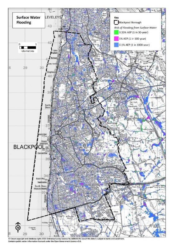
Land Drainage Act (LDA) 1991 (as amended by the FWMA 2010)
On 6th April 2012, Schedule 2 (Sections 31, 32 and 33) of the FWMA amended the Land
Drainage Act 1991 and transferred powers for the regulation of ordinary watercourses to the
Council as LLFA. The powers of the LLFA to regulate ordinary watercourses broadly consist of
two elements; the issuing of consents for any changes to ordinary watercourses that might
obstruct or alter the flow of an ordinary watercourse and enforcement powers to rectify
unlawful and potentially damaging work to a watercourse.

Coast Protection Act 1949 (as amended by FWMA 2010)
This Act gives permissive powers to maritime local authorities (Coast Protection Authorities)
to manage the risks associated with coastal erosion and flooding from the sea. The Act also
defines the boundaries of “the sea” which impacts on funding arrangements for capital
works.

Highways Act 1980
Section 41 of the Act requires the Highway Authority to maintain the highway at public
expense. A highway authority is under a duty to ensure, so far as is reasonably practicable,
that safe passage along a highway is not endangered by snow or ice. It was determined in a
test case that this also includes flood water.

Climate Change Act 2008
This requires a UK-wide climate change risk assessment every five years accompanied by a
national adaptation programme that is also reviewed every five years.

This legislation gives the Government power to require public bodies and statutory
organisations, such as water and sewerage companies, to report on how they are adapting
to climate change.

Water Framework Directive (2000/60/EC) (WFD)
This is a European Directive which aims to protect and improve the water environment. It
is implemented through River Basin Management Plans (RBMPs), and establishes a legal
framework for the protection, improvement and sustainable use of water bodies across
Europe.

WFD applies to all water bodies, including rivers, streams, brooks, lakes, estuaries and
canals, coastal waters out to one mile from low water, and groundwater bodies.

Water Industry Act 1991
This legislation relates to the water supply and the provision of wastewater services in
England. It sets out the main powers and duties of the water and sewerage companies and
defines the powers of the Water Services Regulation Authority (Ofwat).

                                               9
2.2 National Assessments and Plans
In addition to the National Flood and Coastal Erosion Risk Management (FCERM)
Strategy, there are a number of national documents which are relevant to flood and water
management.
A Green Future: 25 Year Environment Plan
The 25 Year Environment Plan (YEP), published in 2018, sets out what government will do to
improve the environment, within a generation, focusing on improving the UK’s air and water
quality and protecting threatened plants, trees and wildlife species. It details how those in
government will work with communities and businesses to do this over the next 25 years.
You can read the full plan here.
The are 10 goals of the Environment Plan (Figure 3), and the one most applicable to flood
and water management is 'reducing the risks of harm from environmental hazards' which will
be achieved through:
• making sure everyone is able to access the information they need to assess any risks to
their lives and livelihoods, health and prosperity posed by flooding and coastal erosion
• bringing the public, private and third sectors together to work with communities and
individuals to reduce the risk of harm
• making sure that decisions on land use, including development, reflect the level of
current and future flood risk
• boosting the long-term resilience of our homes, businesses and infrastructure
The Ten Point Plan for a Green Industrial Revolution
The Ten Point Plan aims to lay the foundations for a Green Industrial Revolution to support
a green recovery mobilising £12 billion of investment in creating green jobs and a green
economy. You can read the plan here.
10In relation to flood and water management, the plan aims to support communities in better
adapting to and offering protection from the effects of climate change by investing in flood
defences and using nature-based solutions to increase flood resilience; this is covered by
point nine 'protecting our natural environment'.
The government is committing £5.2 billion investment in flood defences in a 6 year programme
for flood and coastal defences from April 2021, which will support 2,000 flood schemes across
every region of England and better protect over 336,000 properties from risk of flooding. It
will also fund new innovative approaches to work with the power of nature to not only reduce
flood risk, but deliver benefits for the environment, nature and communities.
National Planning Policy Framework (NPPF)
The National Planning Policy Framework (NPPF) sets out the Government’s planning policies
for England and how these are expected to be applied by Local Planning Authorities (LPA)
and decision-makers, both in drawing up plans and making decisions about planning
applications.
Section 14 of the NPPF sets out how the challenges of climate change, flooding and coastal
change will be approached through planning and development.
You can view the National Planning Policy Framework here.
The interpretation of the NPPF is supported by the Planning Practice Guidance (PPG). This is
a web-based resource which sets out how the government’s planning policies are expected
to be applied in England. The flood risk and coastal change section of the PPG advises how
to take account of and address the risks associated with flooding and coastal change in the
planning process.
In broad terms, this national framework requires plans and developments to:
• Take into account climate change over the longer term to avoid increased vulnerability to
the range of impacts arising from climate change.
• Develop policies to manage flood risk from all sources, taking account of advice from the
flood risk management authorities (RMAs).
• Ensure new development does not increase flood risk elsewhere.
• Avoid inappropriate development in areas at risk of flooding by directing development
away from areas at highest risk.
• Where development is necessary, make it safe without increasing flood risk elsewhere
and direct the most vulnerable development to areas of lowest flood risk.
• Be supported by an appropriate site specific Flood Risk Assessment, where one is
required.
• Ensure development is appropriately flood resilient and resistant.
• Major development should incorporate sustainable drainage systems (SuDS) which
should meet the Technical Standards for SuDS.
112.3 North West Regional Assessments and Plans
North West Flood Risk Management Plan (FRMP)
The Flood Risk Management Plan (FRMP) explains the risk of flooding from rivers, the sea,
surface water, groundwater and reservoirs. FRMPs set out how flood risk management
authorities will work with communities to manage flood and coastal risk.
The North West FRMP covers the river basin catchments of Lancashire and sets out
information on flood risk for the North West river basin district from 2015 to 2021 and a
summary of the aims and actions needed to manage the risk. You can access the current
North West FRMP here. The Environment Agency is leading work to produce a new, updated
North West FRMP that will be available by 2022.
The FRMP is split into 6 documents. These are:
• the summary which gives a high level overview of the FRMP
• Part A includes the legislative background and information for the whole river basin
district (RBD)
• Part B includes detail about each catchment, the flood risk areas and other strategic
areas
• Part C includes the measures identified to manage flood risk across the river basin district
• the Strategic Environmental Assessment (SEA) statement of particulars includes the
potential impacts on people and the environment when implementing the measures in
the FRMP
• the Habitat Regulations Assessment (HRA) details the potential impacts on designated
European sites when implementing the measures in the FRMP
Catchment Flood Management Plans (CFMP)
Catchment Flood Management Plans (CFMPs) are written by the Environment Agency and
aim to establish flood risk management policies which will deliver sustainable flood risk
management for the long term across a catchment.
CFMPs consider all types of inland flooding, from rivers, groundwater, surface water and
tidal flooding. The Shoreline Management Plan (SMP) consider flooding from the sea. CFMPs
also include:
• the likely impacts of climate change
• the effects of how we use and manage the land
• how areas could be developed to meet our present day needs without compromising the
ability of future generations to meet their own needs
12The CFMPs are grouped by river basin district and Lancashire falls within the North West
River Basin District. CFMPs which are relevant to Lancashire are:
• Alt Crossens – Covers West Lancashire
• Douglas – Covers Chorley, South Ribble, West Lancashire
• Irwell – Covers Rossendale
• Lune – Covers Lancaster and parts of Cumbria
• Ribble – Covers Blackburn, Burnley, Fylde, Hyndburn, Pendle, Preston, Ribble Valley,
Rossendale
• Wyre – Covers Blackpool, Wyre and Preston
Whilst not fully superseded by the Flood Risk Management Plan (FRMP), any actions from
CFMP which are still valid will be carried forward to the new FRMP in 2022. CFMPs are,
however, still useful in setting ‘policies’ for each sub-area or ‘policy unit’. There is also much
more detail at a catchment level in CFMPs, for example about how long different rivers take
to rise in response to heavy rainfall.
North West RFCC Business Plan
The North West Regional Flood and Coastal Committee (RFCC) is one of twelve RFCCs in
England, established under the Flood and Water Management Act 2010. The Committee
brings together, with an independent Chair, the flood risk management authorities as a
regional partnership to take an overview of flood and coastal erosion risk management. They
also seek to promote investment and encourage innovation which is good value for money
and benefits communities.
The Committee's Business Plan sets out what it wants to achieve and how. The Business Plan
is not a statutory document but supports the Committee in transparently communicating
and engaging with those who will benefit from the delivery of this work. Business Plan
delivery is supplemented by an annual action plan setting out the actions that will be
delivered in each financial year in more detail, and is closely monitored on a quarterly basis.
You can find the Business Plan here.
Drainage and Wastewater Management Plan (DWMP)
United Utilities will publish their draft Drainage and Wastewater Management Plan in
summer 2022, to support their business plan for the 2024 Price Review.
Drainage and Wastewater Management Plans (DWMP) identify ways that organisations to
work together to improve drainage and environmental water quality. It provides the basis
for more collaborative and integrated long-term planning by water companies, working with
other organisations that have responsibilities relating to drainage, flooding and protection
of the environment. It makes use of the tools and approaches below to enable investment
to be targeted more effectively and provide customers and stakeholders with better
information about the UK’s drainage and wastewater services.
132.4 District Level Assessments and Plans
Preliminary Flood Risk Assessment (PFRA)
A Preliminary Flood Risk Assessment (PFRA), and the identification of ‘flood risk areas’, is
required to be produced by Lead Local Flood Authorities (LLFAs) under Section 10 of the
Flood Risk Regulations (FRRs) 2009. The first PFRAs were produced in 2011 and Section 17
of the FRRs required LLFAs to review their PFRA and ‘flood risk areas’ in 2018. Subsequent
reviews must be carried out at intervals of no more than 6 years.
A PFRA is an assessment of floods that have taken place in the past and floods that could
take place in the future. It considers flooding from surface water runoff, groundwater
and ordinary watercourses. PFRAs are used to identify areas that are at risk of significant
flooding. These areas are called ‘flood risk areas.’ Existing ‘flood risk areas’ have been
identified using guidance produced Defra and represent ‘clusters’ of areas where flood risk is
an issue and where 30,000 people or more live.
PFRAs include:
• a summary of information on significant historic floods;
• a summary of information on future flood risks based primarily on the Environment
Agency's national datasets;
• a spreadsheet containing information for reporting to the European Commission.
PFRA’s for Lancashire can be found on Blackburn with Darwen, Blackpool and Lancashire
County Council websites.
Strategic Flood Risk Assessment (SFRA)
A Strategic Flood Risk Assessment (SFRA) is a study carried out by one or more Local
Planning Authorities to assess the risk to an area from flooding from all sources, now and in
the future, taking account of the likely impacts of climate change, and to assess the impact
that land use changes and development in the area will have on flood risk.
The SFRA is used by the Local Planning Authority to:
• determine the variations in risk from all sources of flooding across their areas, and also
the risks to and from surrounding areas in the same flood catchment;
• inform the sustainability appraisal of the Local Plan, so that flood risk is fully taken into
account when considering allocation options and in the preparation of plan policies,
including policies for flood risk management to ensure that flood risk is not increased;
• apply tests (the Sequential and Exception Tests) when determining land use allocations;
• identify the requirements for site-specific flood risk assessments in particular locations,
including those at risk from sources other than river and sea flooding;
• determine the acceptability of flood risk in relation to emergency planning capability;
• Consider opportunities to reduce flood risk to existing communities and developments
through better management of surface water, provision for conveyance and of storage for
flood water.
14SFRAs in Lancashire can be viewed on the Unitary and District Council Local Planning
Authority websites.
2.5. Types of Flooding and Flood Risk
What causes flooding?
Flooding occurs when water inundates land which is land not normally covered by water,
typically where there is too much water or because the water is in the wrong place. Some
floods develop over days as a result of water taking its time to reach watercourses and
overwhelming them, whilst flash floods generate quickly following intense rainfall or rapid
snow melt.
Whilst flooding is a natural phenomenon, it can result in wide ranging environmental, social
and economic impacts when it interacts negatively with the human environment. There is
hence a need to manage water and flood risk to ensure its negative impacts are minimised.
What is flood risk?
The definition of 'risk' is the combination of the probability (likelihood or chance) of an event
happening and the consequences (impact) of it occurring. Floods can happen often or rarely
and have minor or major consequences. Where the probability and the consequences of
flooding are high, then an area is considered to be at a high risk of flooding.
Flood Risk = Probability x Consequences
Types of Flood Risk
There are many different types of flood risk and flooding can be caused by the interaction
between one or more types of flood risk. This means that flooding can be complex to
understand and difficult to address, so it is important that all flood risk management
authorities work closely together in understanding and managing flood risks.
Figure 4 demonstrates the different types of flood risk, whilst Table 1 describes these risks
and explains which flood risk management authority is responsible for managing each risk.
15Figure 4: Types of flood risk
16Table 1: Types of flood risk and responsible flood risk management authority
Type of flood risk
Surface water flooding is caused by the build-up of water on surfaces because it cannot
soak into the ground due to it being hard paved, frozen, baked solid etc., due to the lay of
the land, or where rainfall exceeds the infiltration capacity of the soil. It often occurs during
intense or prolonged rainfall events.
Responsible Authority
Lead Local Flood Authority (Blackpool, Blackburn-with-Darwen and Lancashire County
Council)
Groundwater flooding occurs when the water table (the water level below ground) rises
above the ground surface. During periods of heavy and prolonged rainfall, the water level
in the ground may rise to such an extent that it seeps into property basements, or the
emergence of groundwater at the surface (can often be a natural spring) may cause damage
to properties and infrastructure. Some areas are known to be more prone to groundwater
flooding than others due to the naturally high level of the water table level in that area.
Responsible Authority
Lead Local Flood Authority (Blackpool, Blackburn-with-Darwen and Lancashire County
Council)
Ordinary watercourses flooding occurs when heavy and/or prolonged rainfall causes the
watercourse to break its banks or when blockages occur (for example by debris or when
infrastructure fails). Ordinary watercourses typically smaller brooks, drainage channels,
ditches, cuts, dikes, sluices, soughs or culverts that may only convey water for a short length
of time in a year.
Responsible Authority
Lead Local Flood Authority (Blackpool, Blackburn-with-Darwen and Lancashire County
Council)
Highway flooding (non-trunk roads) is the accumulation of water on the adopted
Highway network surface. Highway flooding may be caused by blockages or capacity
issues in Highway drainage systems, or simply by sheer volume of rain water falling on the
carriageway, which the existing drainage network cannot cope with has the responsibility to
manage flood risk on the county’s non-trunk roads.
Responsible Authority
Highway Authority (Blackpool, Blackburn-with-Darwen and Lancashire County Council)
17Highway flooding (trunk roads and motorways) is the accumulation of surface water on the
strategic road network.
Responsible Authority
Highways England
Coastal flooding typically occurs when strong winds, wave action, high tides and/or
storm surges, or a combination of these factors during storm conditions, cause coastal
overtopping.
Responsible Authority
Environment Agency
Main Rivers are larger rivers that can span several counties but also include some smaller
watercourses (those which are deemed to require specialist management). The Department
for Environment, Flood and Rural Affairs (Defra) have set the criteria for defining these rivers
as Main Rivers in England and Wales.
Responsible Authority
Environment Agency
Sewer flooding can occur when large volumes of rainwater enters the public sewer system
or when the public sewer system becomes blocked. Flooding from private sewers is the
responsibility of the land owner.
Responsible Authority
Water and Sewerage Companies
Reservoir flooding occurs when a reservoir fails or breaches resulting in this water escaping
and flooding on to the adjacent land. Reservoirs are artificially created ponds or lakes that
are usually formed by building a dam (wall), across a river or watercourse. This type of
flooding is considered to be very low risk as it is highly unlikely to occur.
Responsible Authority
United Utilities
Canal flooding can be as a result of excessive surface water running off or discharging to an
artificially created waterway. The water levels within canals can vary (although not as much
as rivers) due to many factors including proximity to controlled/uncontrolled inflows, lock
usage etc.
Responsible Authority
Canal and River Trust
182.6 Responsibilities of Flood Risk Management Authorities
2.6 Responsibilities of Flood Risk Management Authorities
Lead Local Flood Authorities bring together all relevant Flood Risk Management Authorities
to manage flood risk. No single body has the means to reduce all sources of flooding and
Lead Local Flood Authorities bring together all relevant Flood Risk Management Authorities
thereforetoeveryone has risk.
manage flood a partNoto playbody
single in effective
has the flood
meansrisk management
to reduce forofLancashire.
all sources flooding and
therefore everyone has a part to play in effective flood risk management for Lancashire.
Figure 5 illustrates the key Flood Risk Management Authorities that work together in
Figure 5 illustrates the key Flood Risk Management Authorities that work together in
managing flood risk across Lancashire.
managing flood risk across Lancashire.
Environment Agency
• Main rivers
Highway Authorities
• Coastal / sea
• Highway water
(non-trunk roads) • Reservoirs
Lead Local Flood Authorities
• Surface water
• Groundwater
• Ordinary watercourses
Highways England Water & Sewerage
Companies
• Highway water
(trunk roads) • Public sewer network
District / Borough Councils
• Support Lancashire
County Council where
possible
Figure 5: Flood Risk Management Authorities in Lancashire
Figure 5:Table
Flood2Risk
explains the key responsibilities,
Management duties and powers placed upon flood risk
Authorities in Lancashire
management authorities in Lancashire by the Flood & Water Management Act 2010.
Table 2 explains the key
Under Section 13 responsibilities,
of the Flood and duties and powers Act
Water Management placed
2010,upon
floodflood risk
risk management
management authorities
authorities in aLancashire
each have role to play by the Floodflood
in managing & Water
risk at aManagement
local level and Act
must2010.
cooperate
and ensure a partnership approach is taken to address concerns and maximise opportunities
to holistically
Under Section 13 of manage flood
the Flood andand coastal
Water erosion risks. Act 2010, flood risk management
Management
authorities each have a role to play in managing flood risk at a local level and must
cooperate and ensure a partnership approach is taken to address concerns and maximise
opportunities to holistically manage flood and coastal erosion risks. Page 19
19We have clearly set out how we intend to do this through the delivery of actions set out
within our Business Plan and governed through the Lancashire Flood and Coastal Erosion
Risk Management (FCERM) Partnership and the regional governance of the North West
Regional Flood and Coastal Committee (RFCC). You can find out more about FCERM
governance in 2.8 below and on The Flood Hub.
Table 2: Key Responsibilities, Duties and Powers of Flood Risk Management Authorities
2.7 Responsibilities of Individuals and Communities
Business, land and property owners
Whilst there are a number of organisations and flood risk management authorities who
have a responsibility for the management of the different sources of flooding, an individual
property owner or business still has the responsibility to take measures to protect their
property from flooding.
Flooding can still occurs despite all stakeholders meeting their responsibilities and therefore,
it is important that business, land and property owner take appropriate steps to ensure that
their property and contents are protected where they are known to be at risk.
20The Flood Hub is a North West regionally funded website to support our communities in
understanding how they can become more resilient and resistant to flooding.
Riparian Owners
A riparian landowner is defined as someone who owns land or property next to or over a
river, stream, ditch or culvert/pipe that forms part of a watercourse. The riparian landowner
is responsible for the section of watercourse which flows through their land. If a land
boundary is defined next to a watercourse, it is assumed that the landowner owns the land
up to the centre of the watercourse, unless it is owned by someone else.
Under the Land Drainage Act (1991), riparian landowners have a legal responsibility to maintain
the free passage of water through the section of watercourse that flows through their land.
The Flood Hub is a North West regionally funded website and provide advices and guidance
on riparian ownership.
Developers
Developers are responsible for managing flood risk on-site during development. This should
be considered as part of the site-specific flood risk assessment, where required, and in the
sustainable drainage strategy for the site helping to ensure any phasing of construction
considers how water will be managed. The Local Planning Authority, in consultation with
flood risk management authorities, is responsible for ensuring development is carried
out in accordance with approved plans and, where this is breached, taking appropriate
enforcement action.
2.8 FCERM Governance in Lancashire
The structure of flood and coastal erosion risk management (FCERM) governance in
Lancashire can be split into three hierarchal levels:
North West
Flood & Water Management
Regional Flood and Coastal Committee (RFCC)
RFCC Finance Sub Group
Task Groups (as required)
Lancashire-Wide
Flood & Water Management
Lancashire FCERM Partnership
Strategic Partnership
Tactical Officers Group
District
Flood & Water Management
14x Operational ‘Making Space for Water’ Groups
Figure 6: Regional and Sub-Regional Governance of Flood and Water Management
21North West Regional Flood and Coastal Committee (RFCC)
The North West Regional Flood and Coastal Committee (RFCC) is one of twelve RFCC’s
established in England by the Environment Agency under Section 22 of the Flood and Water
Management Act. The RFCC brings together members (Councilors) appointed by Lead Local
Flood Authorities (LLFAs) and independent members with relevant experience for three key
purposes:
1. to ensure there are coherent plans for identifying, communicating and managing flood
and coastal erosion risks across catchments and shorelines;
2. to provide a link between the Environment Agency, LLFAs, other risk management
authorities, and other relevant bodies to build a mutual understanding of flood and
coastal erosion risks in its area, and;
3. to use this understanding to encourage efficient, targeted and risk-based investment in
flood and coastal erosion risk management that represents value for money and benefits
local communities.
The chair, Adrian Lythgo, is independent and was appointed by the Secretary of State for the
Department for Environment, Food and Rural Affairs. The North West RFCC has a Business
Plan which provides more information about the Committee and its work.
The Committee is supported by a Finance Sub-Group which provokes more detailed
discussion and consideration of financial aspects of Committee business. The Finance Sub-
Group meets four times a year, typically two/three weeks before the main Committee
meeting, and is chaired by another Member of the North West RFCC.
North West and North Wales Coastal Group
The Coastal Group brings together the organisations who manage the coastline from Great
Ormes Head in Llandudno to the Soloway Forth on the Cumbria – Scotland border. The
Group examines the social, economic and environmental issues that arise along the changing
coastline and seek to find the best policies to address these matters.
The Group is supported by two sub-groups: one for Liverpool Bay and a Northern Sub Group
covering north of this. The Northern Sub Group is the sub group relevant to Lancashire and
representatives from our Coast Protection Authorities – Blackpool, Fylde, Lancaster, West
Lancashire and Wyre Councils - attend sub-group meetings held twice a year along with
other partners including the Environment Agency and United Utilities.
The Shoreline Management Plan (SMP) is the key priority that the Coastal Group will oversee
the delivery of. It makes recommendations as to whether maintenance of coastal defences
should continue as they are at present (‘hold the line’), whether maintenance (if any) should
cease (‘no active intervention’) or whether defences, perhaps in years to come, might be
set back further (‘managed realignment’). Walls and embankments are often designed to
protect against both flooding (flood defence/sea defence) and erosion (coast protection).
You can find out more about the North West and North Wales Coastal Group here.
22Lancashire FCERM Partnership
The Lancashire FCERM Partnership is one of five sub-regional FCERM Partnerships in the
North West, alongside the Cumbria, Greater Manchester, Merseyside and Cheshire Mid-
Mersey FCERM Partnerships. These partnerships were created by the North West RFCC to
support local governance of flood and water management and of coastal processes, enabling
local issues and priorities to be governed and reflected appropriately at the North West
RFCC.
The Lancashire FCERM Partnership is a collective grouping of flood risk management
authorities who come together quarterly to take an overview of flood and coastal erosion
risk management across Lancashire, to identify priorities and steer the use of our resources,
to vote on changes to the Local Levy, and to support investment which is good value for
money and benefits our communities.
There are two levels to the partnership:
Strategic Partnership Group
Elected Members and senior representatives from Risk Management Authorities meet four
times a year.
This group is chaired by a Councillor and sets the strategic direction for joint working and
management of flood and coastal erosion risk of the Partnership against its resources, local
risks and challenges.
Group agrees the timetable delivery of actions identified in the Strategy’s Business Plan
according to many factors such as delivery timescales and what will have the greatest
benefit to our at risk communities.
Tactical Officers Group
This is chaired by a Local Authority officer and is where technical lead officers deliver actions
set by the Strategic Partnership Group. The group meets four times a year to coordinate
delivery, share skills and implement decisions.
Lead officers also report on issues, successes and identify ways to continually improve the
management of flooding and coastal erosion risks into the future.
23Local Authority Operational 'Making Space for Water' Groups
Operational 'Making Space for Water' Groups are district-level technical partnership groups
set up to discuss locally specific flood and coastal, where applicable, issues within their Local
Authority area and provide a forum to drive forward solutions, where possible, through
working in partnership.
These technical meetings are arranged and chaired by Local Authorities who, where
applicable, feed outcomes of this meeting up to Tactical Officers Group and to the Northern
Coastal Sub-Group as well as feeding information down to the Operational 'Making Space for
Water' Group.
2.9 Working with our Wider Partners
Catchment Partnerships
Catchment Partnerships are local formed groups which advocate for a Catchment Based
Approach (CaBA) to undertake integrated management of land and water, addressing
each river catchment as a whole and delivering crosscutting practical interventions on the
ground. These result in multiple benefits including improvements to water quality, enhanced
biodiversity, reduced flood risk, resilience to climate change, more resource efficient and
sustainable businesses and, health and wellbeing benefits for local communities as they
engage with and take ownership of their local river environment.
Numerous organisations and sectoral interests are involved with Catchment Partnerships
in Lancashire, including the Environment Agency, United Utilities, Local Authorities,
Landowners, Wildlife Trusts, National Farmers Union, Academia and Local Businesses.
In Lancashire there are five Catchment Partnerships covering the Alt Crossens, Douglas,
Irwell, Lune, Ribble and Wyre Catchments which are chaired by Rivers Trusts and
Groundwork.
You can find out more about them here.
Whilst not a flood risk management authority, Catchment Partnerships are a recognised and
valued groups which support us in, where possible:
• delivering a catchment-based approach (CaBA) to flood and water management
• helping to drive improvements in water and bathing water quality locally
• championing the use and delivery of natural flood management techniques across
Lancashire.
Flood Action Groups (FlAGs)
A Flood Action Group (FlAG) is a voluntary group of local residents who meet on a regular
basis to work on behalf of the wider community to help to try and reduce the impact of
future flood events. Across Lancashire, there are around 50 FlAGs and, whilst the focus of
the group can vary, is typically based around emergency planning and can also tackle local
issues, whilst providing a unified voice for the community to communicate ideas and queries
to others.
24It is within the remit of each individual group to decide on its own roles, responsibilities,
aims and objectives. For more information please see The Flood Hub.
Detailed information describing the achievement of a Community Group at Churchtown
and future opportunities for other Flood Action groups can be found on this link:
https://thefloodhub.co.uk/wp-content/uploads/2019/12/Churchtown-Flood-Action-Group-
case-study.pdf
Lancashire Resilience Forum
The Lancashire Resilience Forum (LRF) is a multi-agency partnership made up of
representatives from local public services, including the emergency services, local
authorities, the NHS, the Environment Agency, United Utilities, Maritime Coastguard Agency
and others. These agencies are known as Category 1 Responders, as defined by the Civil
Contingencies Act.
These multi-agencies work together to prepare and respond to emergencies in Lancashire,
including flooding. You can find out more about the Lancashire Resilience Forum here.
2.10 Funding for FCERM
FCERM Investment Programme 2021 - 2027
The Flood and Coastal Erosion Risk Management (FCERM) Investment Programme is a Defra
capital investment plan to better protect homes and non-residential properties, such as
businesses, schools and hospitals, from flood risk and coastal erosion. The conditions of the
Investment Programme are that schemes must attract at least 15% of partnership funding
and deliver 10% efficiency saving on projects. This flood and coastal erosion resilience
partnership funding policy was introduced to spread the cost between government funding
and local funding partners.
In the 2020 Budget, the government announced that it will double its investment in flood
and coastal defences in England, compared to the previous capital investment plan, to £5.2
billion to better protect a further 336,000 homes and non-residential properties as well as
avoiding £32 billion of wider economic damages to the nation.
The Prime Minister also announced a new £200 million resilience fund to pilot innovative
approaches to improving flood resilience between 2021 and 2027. This will support 25 local
areas to take forward wider innovative actions that improve their resilience to flooding and
coastal erosion.
In addition to doubling its spending on flood and coastal defences, the government has
worked with the Environment Agency to update how the level of government funding is
allocated to projects. The changes will take account of the wider environmental and social
benefits that come with reducing the risk of flooding.
25The changes will include:
• updated payments to account for inflation and based on new evidence on the overall
impacts of flooding, such as mental health
• increased payments for flood schemes which also create a range of environmental
benefits
• more funding for flood schemes which also protect properties that will later become at
risk of flooding due to climate change
• a new risk category which will enable schemes that prevent surface water flooding to
qualify for more funding
• New funding streams will also mean:
• more money for flood defence schemes that help to protect critical infrastructure such as
schools, hospitals, roads and railways
• more money to upgrade existing Environment Agency defences
Funding for Delivering Projects
The following funding sources allow the LLFA to reduce flood and coastal erosion risk
through the delivery of projects:
• Flood Defence Grant in Aid (GiA) – This is money from Defra which is administered by
the Environment Agency. The amount of Grant in Aid available to each capital scheme is
calculated by the Outcome Measures delivered by the project. Outcome Measures reflect
financial, environmental, health and FCERM benefits. Where there is a shortfall in Grant
in Aid, funding contributions are required to achieve project viability.
• Local Levy – The North West RFCC (and Yorkshire RFCC for Earby) can choose to support
projects that are either not eligible for Grant in Aid, or to support projects where there is
a shortfall in Grant in Aid by the allocation of Local Levy.
• Partnership Funding – Where Grant in Aid and/or Local Levy does not fully support
the delivery of a project, the LLFA can provide additional funding through their own
contributions or by seeking external contributions from partners and communities who
may benefit from the project.
Funding allocations for these sources are subject to a successful, approved business case.
More information on investment in FCERM can be found in the North West RFCC Business
Plan (available on The Flood Hub) and statistics can also be found on GOV.uk.
263. Local Flood Risks & Challenges
3.1 Local Flood Risks
Increasing local flood risks as a result of climate change
The UK Climate Projections 2018 (UKCP18) illustrate a range of future climate scenarios
until 2100. In relation to managing the risk of local flooding average summer rainfall could
decrease by up to 47% by 2070, while there could be up to 35% more precipitation in winter.
What rainfall does occur will be more intense over a shorter duration, which could lead to an
increase in surface water flood risk.
This is complicated by sea levels which are projected to rise over the 21st century and
beyond under all emission scenarios, meaning we can expect to see an increase in both the
frequency and magnitude of extreme water levels around the UK coastline. This can impact
on local flood risk by affecting the ability of catchments to discharge.
UKCP18 can be used as a tool to guide decision-making and boost resilience – whether
that’s through increasing flood defences, designing new infrastructure or adjusting ways of
farming and land management for drier summers. It will also help us at a local level to feed
into future development plans to ensure they take account of and are resilient to flood and
coastal erosion risks.
Most Lancashire Local Authorities have declared a climate emergency committing to taking
action to reduce carbon emissions, raise awareness about climate change and mobilise
change through local action.
Inherited local flood risk from historical development
Development today is well regulated through the planning process, and this includes
measures to understand, mitigate and manage flood risks from all sources on prospective
sites. As well as planning regulation, building regulations and design specifications have
changed and improved over time to reflect advances in knowledge and understanding of
drainage and in response to our changing climate.
It is therefore not surprising that older developments, constructed at a time when due
consideration to drainage did not occur as it does now, are finding they are at flood risk
today as a result of our changing climate and pressures on historical drainage systems not
designed and constructed to modern standards.
Predominant surface water flood risk
Surface water flooding from short, intense storms can occur in urban areas and along
highways when drains are overloaded by the sheer amount of rainfall and/or runoff.
27Sefton has the highest number of properties at high risk of surface water flooding both in
Merseyside and in the North West, largely as a result of its urban areas generating surface
water flows, flat topography meaning the water isn’t easily moved away and the presence of
sea defences.
The figures in Table 2 are ‘with defences’. Those for rivers and the sea would be much
higher were it not for these defences, especially in Wirral and Sefton. This underlines the
importance of maintaining flood and coastal assets and periodically upgrading them.
Groundwater risks in low lying areas
In low-lying areas the water table is usually at shallower depths, but during very wet periods,
with all the additional groundwater flowing towards these areas, the water table can rise up
to the surface causing groundwater flooding.
Groundwater flooding is most likely to occur in areas situated over permeable rocks, called
aquifers. These can be extensive, regional aquifers, such as chalk or sandstone, or may be
more local sand or river gravels in valley bottoms underlain by less permeable rocks.
Hence groundwater flood risks in Lancashire tend to be prevalent in lower lying areas
underlain by permeable rocks and soils as is typical throughout the West Lancashire plain
and the Fylde Peninsula.
Drainage infrastructure which is aging and at capacity in areas
Lancashire has an intricate network of ageing culverts, sewers and drains, many dating from
the 1800s when cotton industry was expanding during the Industrial Revolution.
This ageing infrastructure, along with pressures from development and a tendency for
increased paving such as driveways, poses particular problems to the drainage network. As a
result, some areas have experienced flooding from sewers which occurs when their capacity
is overcome by the amount of water trying to enter the network.
In urban areas watercourses are typically modified with straightened and walled channels,
and there are many culverts; watercourses which have been re-directed through pipes and
tunnels.
Many watercourses reflecting land that has been reclaimed and/or managed
Lancashire's western districts are characterised by large areas of reclaimed land with a
distinctive pattern of rectangular fields of dark peaty soil with deep drainage ditches. This
land is highly fertile, top grade agricultural land with a vibrant intensive farming economy.
It is common to find the suffix "Moss" in the names of local places. As is usual in these
types of areas, the settlements tend to be on any available hill, many formed by sandstone
outcrops, to avoid the risk of flooding.
28You can also read