Natural Resources Management Plan 2018-2020 - ANL-18/19
←
→
Page content transcription
If your browser does not render page correctly, please read the page content below
Natural Resources Management Plan
                          2018–2020

                           ANL-18/19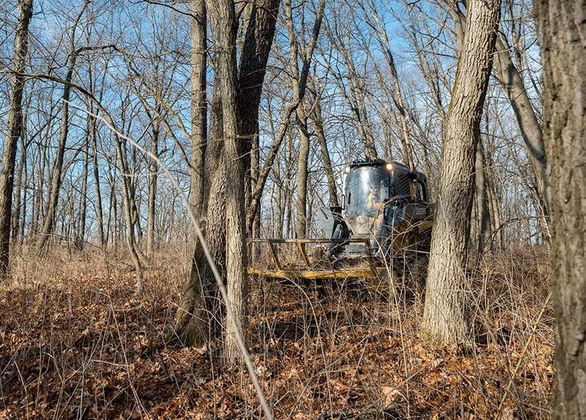
NATURAL RESOURCES MANAGEMENT PLAN, 2018–2020

                                                      Contents

1.0 Purpose .................................................................................................................. 1
2.0 Background ........................................................................................................... 2
3.0 Define Land Use Areas ......................................................................................... 5
4.0 Natural Resources: Habitat Management Strategy ............................................ 8
5.0 Goals and Objectives .......................................................................................... 12
6.0 Roles and Responsibilities................................................................................. 18
7.0 Implementation and Monitoring ......................................................................... 19
8.0 References ........................................................................................................... 20
Appendix A: Plant Communities of the Argonne Site ............................................ A-1
Appendix B: Ecosystem Management Units .......................................................... B-1
Appendix C: Legislative and Regulatory Requirements for Natural
            Resource Management on Federal Lands ........................................ C-1
Appendix D: Site Landscape Plant List ................................................................... D-1
Appendix E: Invasive Species Management ............................................................ E-1

                                                        Figures
1       Aerial view of the Argonne site today. .................................................................... 1
2       Aerial image of the Argonne site from 1939 showing farmland, woods, and
        open space. ........................................................................................................... 2
3       Relationships between Executive Orders, Congress, the U.S. Department of
        Energy, and the Argonne site. ............................................................................... 3
4       The Hine’s Emerald Dragonfly, a federally endangered species documented
        at several locations on the Argonne site. ............................................................... 4
5       Argonne campus plan. ........................................................................................... 5
6       GIS map showing Ecosystem Management Units, their respective
        numbers, and their improvement with management. ............................................. 7
7       Lessons learned process map. .............................................................................. 9

Argonne National Laboratory                                                                                                    iii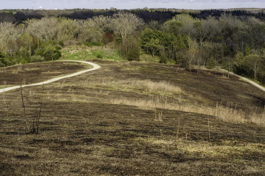
NATURAL RESOURCES MANAGEMENT PLAN, 2018–2020

                                               Figures (Cont.)
8     Phragmites australis (common reed), an invasive plant species
      found on the Argonne site. ................................................................................... 10
9     Wetland on the Argonne site................................................................................ 11
10    Trillium grandiflorum (great white trillium). ........................................................... 12
11    Rhamnus cathartica (common buckthorn), an invasive shrub species
      found on the Argonne site. ................................................................................... 14
12    Northern Illinois habitat following prescribed burning. .......................................... 15
13    Argonne’s Advanced Protein Crystallization Facility landscaped with
      native flora. .......................................................................................................... 16
14    Argonne Infrastructure Services grounds staff member operating a
      Bobcat® forestry device. ...................................................................................... 18
15    Three-year management planning units. ............................................................. 19
E-1   Invasive Species Adaptive Management. ......................................................... E-11

                                                       Tables
1     Fiscal Timeframe Completion of Goals, Objectives, and Projects ....................... 17
E-1   Control of Invasive Plant Species at the Argonne Site ........................................ E-6

iv                                                                                          Argonne National Laboratory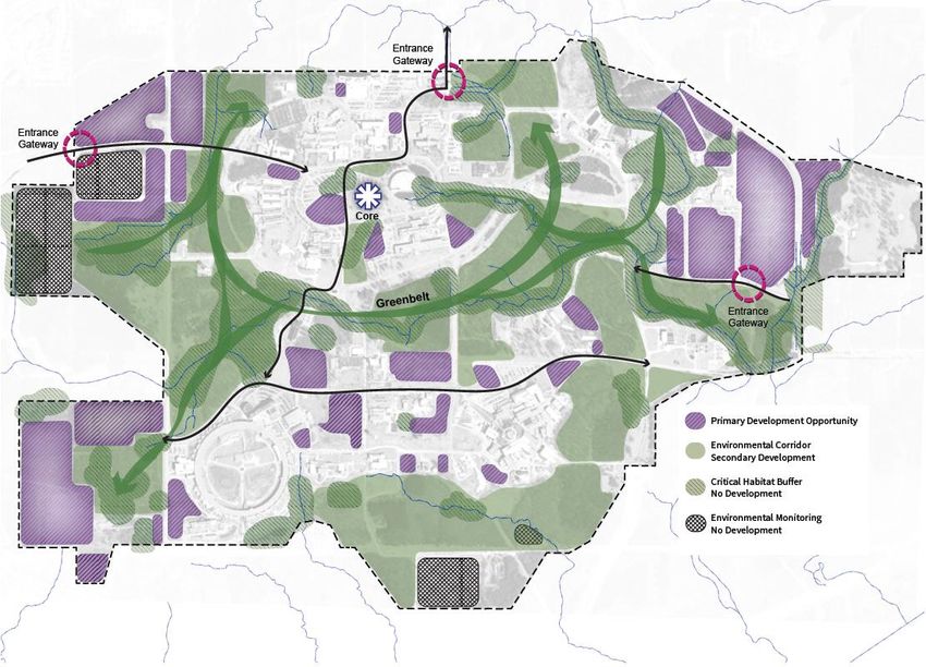
NATURAL RESOURCES MANAGEMENT PLAN, 2018–2020

1.0 Purpose
Argonne National Laboratory is located on a 1,500-acre site comprised of a developed campus
located within large tracts of undeveloped land (Figure 1). Approximately a third of the site
consists of buildings, roads, parking lots, and support infrastructure.(1) The remaining portion is a
complex of natural resources that include woodlands, prairie and grasslands, wetlands, and open
space. Some of these areas are reserved for future development while others represent valuable
ecosystems and potential protected habitat. Therefore, a series of natural resource management
plans have been prepared for the management of the undeveloped campus within the context of
mission need and overall site management requirements.(2,3)

   FIGURE 1 Aerial view of the Argonne site today. Photo credit: Argonne National
   Laboratory.

This edition of the Natural Resources Management Plan is an action course for the next three
fiscal years, 2018-2020. It builds on the progress of the three previous years — increasing
floristic quality in habitats throughout the site, reducing the footprint of several invasive species
populations, and introducing new techniques for contractors and grounds personnel, with a goal
of increasing the overall size of on-site healthy ecosystems. In this next period, intensive
mechanical control of invasive species will transition to more tailored tools such as controlled
burning. Floristic quality assessment and species nomenclature have been improved for the
Chicago region, and that will prompt a transitional period and effort to update field surveys and
report development. Many lessons learned will refine our natural resource management efforts.

Argonne National Laboratory                                                                             1
NATURAL RESOURCES MANAGEMENT PLAN, 2018–2020

2.0 Background
In 1947, the land that became Argonne National Laboratory was in either (a) a natural state or
(b) used for agriculture, as the Chicago region was just beginning its vast suburban development
that occurred in the second half of the 20th century (Figure 2). Hence, habitats on the site were
used for buffer space and screening as the communities that now surround it grew. In recent
decades, the remaining natural areas (habitats) in urban regions and in the nation as well have
become more valuable as their representation has diminished while their social and economic
utility has increased significantly. During this same period, regulatory management of the
environment has increased at every level of governance — federal, state, county, and municipal,
and extending to private entities, as the relationship between humans and the natural world has
increased in complexity.

          FIGURE 2 Aerial image of the Argonne site from 1939 showing farmland,
          woods, and open space. Photo credit: Argonne National Laboratory.

The U.S. Department of Energy (DOE) Order 430.1C Real Property Asset Management(4) is the
primary directive for Argonne’s natural resource management. This Order instructs the agency to
ensure that applicable requirements related and not limited to “natural resource preservation” are
addressed.(5) Those requirements exist, however, in addition to the laboratory’s mission and to
those actions that are more clearly defined in the order as real property asset management. It
follows that the management of Argonne, as a federal government facility, must meet all

2                                                                      Argonne National Laboratory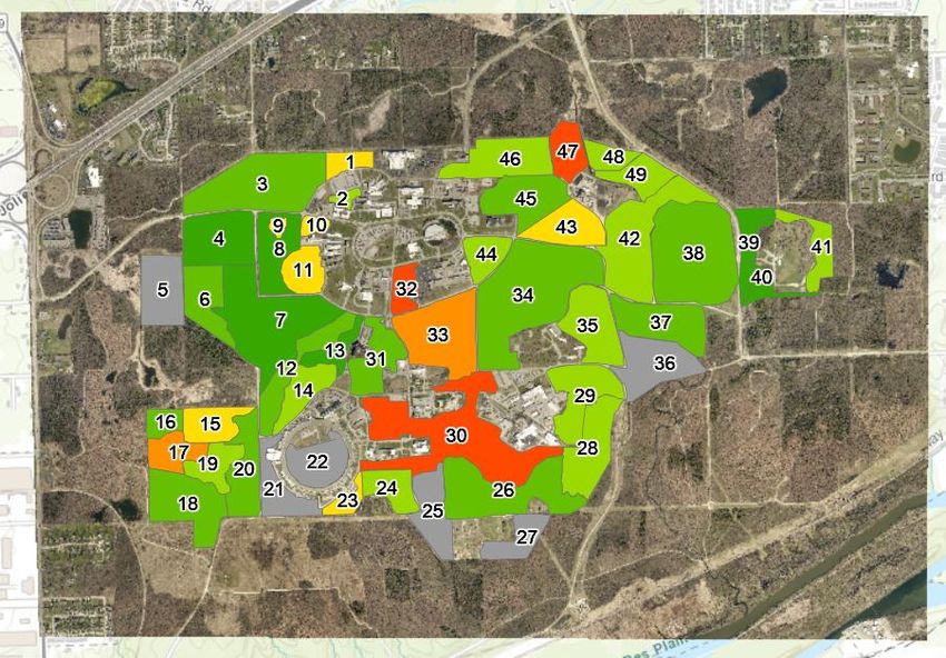
NATURAL RESOURCES MANAGEMENT PLAN, 2018–2020

regulatory requirements in addition to its direct scientific mission. The Argonne Site Office
monitors the laboratory’s compliance with this and other directives and statutes.

An assessment of the site’s natural resources with other applicable federal statutes and
requirements that affect those resources, reveal two general courses of action that are reflected in
the goals of this management plan. The site’s natural resources are to be maintained and
improved in quality and threats to those resources are to be reduced and controlled. For all
federal agencies, two executive orders also provide executive direction:

   1. Executive Order 11990, “Protection of Wetlands,” which directs agencies to minimize
      the destruction, loss, or degradation of wetlands and to preserve and enhance the natural
      and beneficial values of wetlands; and Title 10 of the Code of Federal Regulations, Parts
      1021 and 1022, which is DOE’s implementation of this executive order; and
   2. Executive Order 13751, “Safeguarding the Nation from the Impact of Invasive Species,”
      which directs federal agencies to control populations of invasive species and provide for
      the restoration of native species and habitats in affected ecosystems.

These two orders overlap in scope to cover all of the site’s natural resources. Next, Acts by
Congress provide further direction for the management of natural resources (Figure 3).

 Executive – The President                     Department of Energy                  Argonne Site
 Executive Order 11990                         Department of Energy                  Natural
 Protection of Wetlands                        Orders 1021 and 1022                  Resources
                                                                                     Management
 EO 11988 Floodplain                                                                 Plan
 Management

 Executive Order 13751
 Safeguarding the Nation
 from...Invasive Species
 Congress
 National Environmental Policy                 Department of Energy (DOE)
 Act                                           Order 430.1C
                                               Real Property Asset
 Endangered Species Act                        Management

 Migratory Bird Treaty Act

 Clean Water Act
FIGURE 3 Relationships between Executive Orders, Congress, the U.S. Department of Energy,
and the Argonne site.

Argonne National Laboratory                                                                         3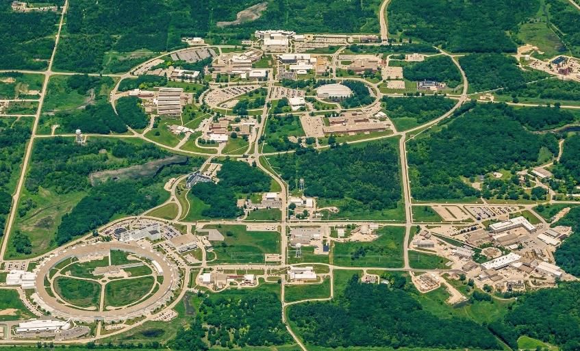
NATURAL RESOURCES MANAGEMENT PLAN, 2018–2020

Argonne’s natural resources include a threatened and endangered species. The Endangered
Species Act 1973 (ESA) requires federal agencies to use their legal authorities to aid in the
conservation of listed threatened or endangered (T&E) species. The Hine’s Emerald Dragonfly
(HED) (Figure 4), a federal endangered species is, as of 2016, known from several locations on
the Argonne site. Six other threatened and endangered species are in DuPage County: four
plants, another insect, and one mammal species. At least two of those, the northern long-eared
bat and the rusty-patch bumble bee, may visit and forage the site in the summer months. Argonne
complies with the Endangered Species Act by protecting and enhancing the habitats of known
T&E species present and conducting continuous monitoring of the site in search of the other
species known from DuPage County. Discovery of threatened and endangered species is
documented in the laboratory’s annual site survey report, and Argonne maintains an active
dialogue with the US Fish and Wildlife Service regarding the status of T&E species on the
Argonne site. In addition to the ESA, other statutes have requirements regarding natural resource
management (Appendix C), such as the Clean Water Act, which regulates pollution, storm water
discharges into waterways, and impacts to wetlands, and many of these statutes have
implications for natural resource management.

         FIGURE 4 The Hine’s Emerald Dragonfly, a federally endangered species
         documented at several locations on the Argonne site. Photo credit: Paul
         Sparks/Shutterstock.com.

4                                                                     Argonne National Laboratory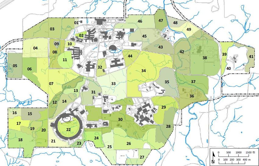
NATURAL RESOURCES MANAGEMENT PLAN, 2018–2020

3.0 Define Land Use Areas
The 2016 Argonne Facilities and Infrastructure Strategic Investment Plan describes the overall
management of the Argonne site to meet the scientific mission of the laboratory and fulfill the
requirements of DOE. The plan classifies the site into the Primary Development, Environmental
Corridor, Critical Habitat Buffer, and Environmental Monitoring (Figure 5). The Primary
Development areas include existing programmatic mission areas, support services, and
housing/amenities and areas identified as suitable for future development. The Environmental
Corridor consists of sites that can accommodate future development for programmatic mission
and support services, but also currently have significant natural resources. The Critical Habitat
Buffer includes areas designated as open space and environmentally sensitive areas primarily
within and adjacent to the 100-year floodplain.

FIGURE 5 Argonne campus plan.

Argonne National Laboratory                                                                         5
NATURAL RESOURCES MANAGEMENT PLAN, 2018–2020

The Critical Habitat Buffer and Environmental Corridor host the majority of Argonne’s natural
resources. They comprise a number of different habitat types (Appendix A). Those resources are
sub-divided into ecosystem management units (EMUs) to facilitate management (Appendix B).
Roads, buildings or other constructed features often arbitrarily define ecosystem management
units. EMUs typically include a predominant habitat type, but may contain more than one plant
community. The boundaries of each unit can be adjusted in annual revisions of this management
plan, based on changes in plant community characteristics or changes in management approach.

The depth of this analysis has facilitated progress in natural resource management objectives
thus far. Populations of many invasive species have been reduced, habitats have improved in
quality and biodiversity, and the site’s wetlands have been removed from regulatory compliance
obligations. Those achievements create a new advanced baseline for more progress; however,
invasive species populations and other threats are resilient, and any progress can easily be lost
due to inconsistent focus or inaction (Figure 6).

6                                                                      Argonne National Laboratory
NATURAL RESOURCES MANAGEMENT PLAN, 2018–2020

FIGURE 6 GIS map showing Ecosystem Management Units, their respective numbers, and their
improvement with management.

Argonne National Laboratory                                                                7
NATURAL RESOURCES MANAGEMENT PLAN, 2018–2020

4.0 Natural Resources: Habitat Management Strategy
Argonne has generated a significant amount of information on the historic and current condition
of the site’s habitats through various surveys, research, and regulatory analyses. Annual
vegetation assessments provide information on extant conditions, in particular, the status of
T&E species and recommendations for habitat improvement. The wetlands have regulatory
obligations that have resulted in a significant body of studies and reports (see References). There
are other reports on birds, reptiles, and the greater surrounding Waterfall Glen Forest Preserve.
These examinations of the site’s natural resources reveal that the site retains a range of
components from its former ecology. This information supports a management plan focusing on
remnants of the pre-settlement plant community structure and species composition in the context
of still-functioning abiotic processes such as hydrology, soil types, weather, and climate.

Natural habitats on the Argonne site formed over a considerable period of time and have been
influenced by a variety of factors, particularly recent man-made alterations and influences. Those
factors include soils, hydrology, landscape position, topography, slope and aspect, and the
succession sequence of plant communities (See Appendix A, Plant Communities of the Argonne
Site). The long-term goal of Argonne’s natural resource management effort is to (a) reduce
threats to habitat integrity, (b) due to significant site disturbance over more than 70 years,
promote habitat dynamics of biotic and abiotic interactions, and (c) realize the maximum
potential of the site’s natural resources — biodiversity, ecosystem services, and green
infrastructure. This goal fulfills all of the regulatory obligations for managing the Argonne site.

Ecologists determine the quality of a habitat by its vegetation community. That community
forms the primary support for all other organisms, and there is a direct relationship between the
quality of a plant community and the welfare of all other life. The standard assessment tools used
to measure habitat integrity and change are the Floristic Quality Index (FQI) and Mean C values.
These two inter-related values depict the quality of the vegetation and its integrity in response to
disturbances. Successive assessments reveal how the vegetation quality responds to management
actions. Vegetation in the mid-west region typically responds to management actions within
three years; therefore, the site is divided into three management sections, and this assessment is
conducted on one of those three divisions every year, in rotation. Usually, the FQI value will
show an incremental increase over time in response to appropriate management actions.
Ecosystem management units have current and historic FQI and Mean C values calculated from
at least six years of consistent assessments. In-depth methodology and findings of this
assessment are discussed annually and reported in the Argonne National Laboratory Ecology
Survey.

In the Chicago region, sites of 10 or more acres that have both high FQIs and Mean C values are
very rare, due to the region’s vast urban development. This represents less than 0.5% of the
region’s land cover. Average FQI of sites in the Chicago region is 40; Argonne has several sites
that exceed an FQI of 50. Optimum Mean C in the Chicago region is 5; Argonne sites have a
Mean C of 4.0. In addition, several other locations approach those values in such a way that

8                                                                       Argonne National Laboratory
NATURAL RESOURCES MANAGEMENT PLAN, 2018–2020

those, too, will become high-quality natural areas with continued management. In order to realize
the long-term goal to maximize values provided by the site’s natural resources — biodiversity,
ecosystem services, and green infrastructure, all FQI and Mean C values of individual EMUs
should be rising with management, especially where those EMUs still possess elements of their
historic ecology. See Floristic Quality Assessment, Revised, by Wilhelm and Masters(6) for an
extensive discussion of the methodology of floristic assessments.

Argonne applies an integrated approach to managing the site’s natural areas, determining priority
with consideration to the condition of site resources against available funds, labor, and
equipment. Hence, habitats with the highest quality ratings will receive management priority
before lower-quality areas, so as to avoid backsliding to degraded quality. Where prioritization is
required among communities with similar FQIs, those EMUs occurring within the Critical
Habitat Buffer will receive the highest priority, followed by those in the Environmental Corridor,
and then those in the developed areas (Figure 5). Effort in the secondary low-quality and
developed areas generally is intended more to address invasive species or other concerns rather
than to improve habitat; however, there may be exceptions where important natural resources can
be preserved in the context of potential development (Figure 7). This approach is inherent in the
goals and objectives stated below.

                                      5. Consider
                                          next                       1. Propose
                                       action(s)                    management
                                     including no                       action
                                         action

                              4. Evaluate
                              the habitat
                                                                            2. Conduct
                               response,
                                                                               action
                              vegetation
                                quality

                                                     3. Allow for
                                                        habitat
                                                    response 1- 2
                                                         years

                  FIGURE 7 Lessons learned process map.

Treatments are then selected that will improve habitat quality and reduce/control threats, mainly
populations of invasive species. These may include native species augmentation, various
methods of invasive species control that include prescribed fire, physical or chemical treatments,
restoration of hydrology where appropriate, and deer management. Treatments are then assessed
to determine both effectiveness and need for additional effort. Disturbed habitats typically
require a continuous program of effort. Appendix E contains a more detailed Invasive Species
Management Plan describing various control techniques employed by the laboratory.

Argonne National Laboratory                                                                       9
NATURAL RESOURCES MANAGEMENT PLAN, 2018–2020
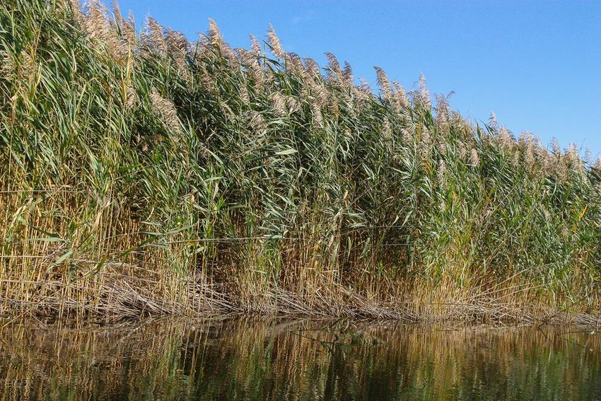
FIGURE 8 Phragmites australis (common reed), an invasive plant
species found on the Argonne site. Photo credit: Svetlana
Mahovskaya/Shutterstock.com.
The management strategy for wetlands receives particular attention from the Argonne Site
Office. A permit is required for construction, dredging or filling, hydrology alteration, or other
impacts to wetlands that may alter their condition as wetlands. These permits are issued by the
Department of Energy and, where applicable by statute, by the United States Army Corps of
Engineers. Much of the wetland effort managed under this plan is similar to work conducted in
other habitats on the Argonne site — intended to control invasive species populations and
improve vegetation quality.(7) Wetlands will also benefit from improvements to upland areas, in
particular, where upland habitat improvements restore hydrology processes such that water tables
contribute to the influx of standing water of wetlands, and the depth of the water table influences
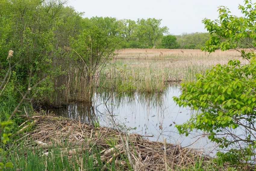
plant distribution and diversity (Figure 9).
Overall, wetland size in acres is relatively small, about 50 acres, in relation to the size of the
Argonne site (1,500 acres); however, the habitat type is complex and has the potential to be
among the most diverse on the property. Two wetlands are host to reproduction of the Hine’s
Emerald Dragonfly, and others provide suitable habitat for reproduction and other behavior.
10 Argonne National LaboratoryNATURAL RESOURCES MANAGEMENT PLAN, 2018–2020
FIGURE 9 Wetland on the Argonne site. Photo credit: Argonne
National Laboratory.
Argonne National Laboratory 11NATURAL RESOURCES MANAGEMENT PLAN, 2018–2020
5.0 Goals and Objectives
The goals of Argonne’s Land Management and Habitat restoration program (Table 1) present a
broad vision of desired conditions on the Argonne site and direct the implementation of this plan
for the next three years. Objectives more specifically describe management initiatives or
strategies designed to achieve each goal. The goals and objectives are based on the management
principles discussed in Section 4 and in Appendix A.
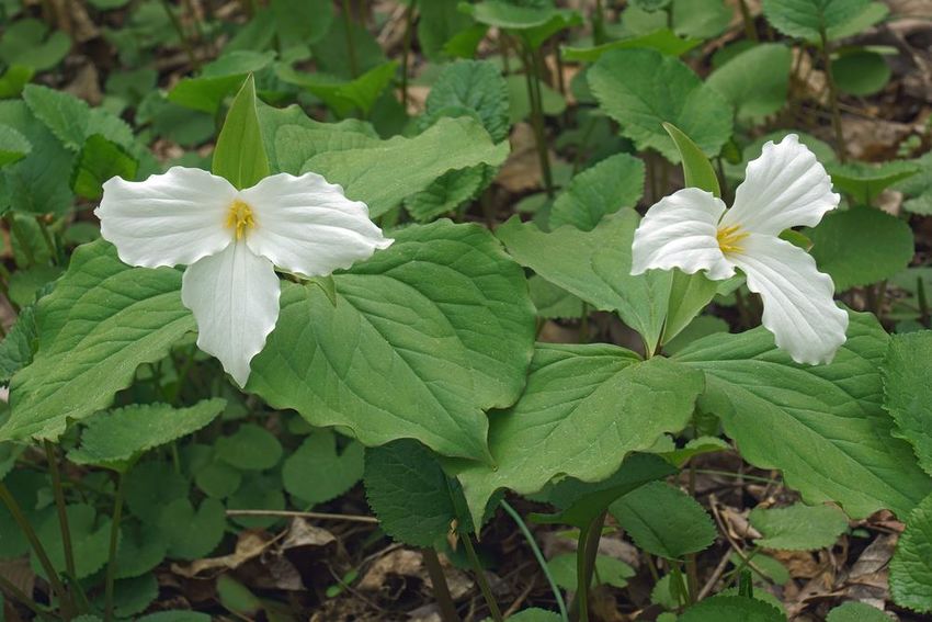
GOAL 1. Maintain high-quality remnant plant communities on the Argonne site (Figure 10).
FIGURE 10 Trillium grandiflorum (great white trillium). Photo credit:
Nikolay Kurzenko/Shutterstock.com.
Objective 1.1. Monitor natural areas to determine existing conditions, response to management
actions, and resource threats.
Project 1.1.1. Survey one-third of the Argonne site natural areas each year, to include
uplands and wetlands; update species lists for each land management tract; identify the
presence of T&E species, document conditions, plant community, invasive species
concerns and other threats.
Project 1.1.2. Develop, maintain, or revise management plans for individual ecosystem
management units. Modify management plans based on previous annual survey results.
12 Argonne National LaboratoryNATURAL RESOURCES MANAGEMENT PLAN, 2018–2020
Project 1.1.3. Determine the status of threatened and endangered species at Argonne by
consulting with the U.S. Fish and Wildlife Service (USFWS).
Objective 1.2. Focus management actions in previously managed sites, wetlands, and threatened
and endangered species habitat.
Project 1.2.1. Conduct restoration activities (e.g., burns, cutting) on previously treated
areas, based on three-year cyclic management plan schedules.
Project 1.2.2. Incorporate non-compliance wetlands into this Natural Resources
Management Plan framework from previous division management. The laboratory’s
Infrastructure Services Natural Resources Manager will coordinate program history and
data from the appropriate personnel, including appropriate transfer of budget authority.
Project 1.2.3. Conduct habitat restoration techniques with protocols to avoid harm to
threatened and endangered species.
Sub-Project 1.2.3.1. Conduct improvement effort in Hine’s Emerald Dragonfly
habitat following Argonne’s Inter-Service Hine’s Emerald Dragonfly Technical
Guidance from USFWS. See Appendix B, EMUs 03 and 26.
Sub-Project 1.2.3.2. Conduct habitat improvement efforts with situational
awareness of potential T & E species presence See ASO-CX-344 Habitat
Maintenance Activities.
Project 1.2.4. Preserve site-wide oak tree health.
Sub-Project 1.2.4.1. Inspect and record oak trees displaying signs of premature
decline.
Sub-Project 1.2.4.2. Treat oak trees in decline with plant health care treatments.
Sub-Project 1.2.4.3. Plant oak trees in the landscape of developed areas to
maintain oak presence with at least one oak tree planted for each oak tree death.
Sub-Project 1.2.4.4. Install mulch beds around oak trees and groups of oak trees.
Sub-Project 1.2.4.5. Plant mulch bed with selected ground cover of compatible
species: native species found in local oak savannah ecosystems.
Objective 1.3. Expand restoration activities into selected remnant plant communities from high
quality areas to those that are lower quality.
Project 1.3.1. Develop a restoration plan for selected management unit(s) and initiate
activities.
Sub-Project 1.3.1.1. Remove 30 to 50 acres of invasive shrub infestation
(e.g., buckthorn, honeysuckle, etc.) in wooded ecosystem management units
annually with mechanical clearing.
Sub-Project 1.3.1.2. Control cool-season grasses in prairie management areas to
eliminate competition with native plants.
Argonne National Laboratory 13NATURAL RESOURCES MANAGEMENT PLAN, 2018–2020
GOAL 2. Conduct Invasive Species Control/Integrated Pest Management Plan (Appendix E) for
identified populations throughout the site (Figure 11).
FIGURE 11 Rhamnus cathartica (common buckthorn), an invasive
shrub species found on the Argonne site. Photo credit:
Nelly B/Shutterstock.com.
Objective 2.1. Identify and control new and/or existing invasive plant species.
Project 2.1.1. Identify herbaceous invasive species with localized populations based on
results of annual site surveys.
Project 2.1.2. Implement invasive tree/shrub/vine control actions per the Invasive
Species Control Plan
Objective 2.2. Detect, identify and control potentially harmful insect populations.
14 Argonne National LaboratoryNATURAL RESOURCES MANAGEMENT PLAN, 2018–2020
GOAL 3. Re-establish natural plant communities in the critical habitat buffer or environmental
corridor (Figure 12).
FIGURE 12 Northern Illinois habitat following prescribed burning.
Photo credit: ESB Basic/Shutterstock.com.
Objective 3.1. Identify/select appropriate locations to re-establish native plant communities.
Project 3.1.1. Identify areas currently lacking native plant communities and develop
appropriate management strategy. Priority will be based on (1) potential spread or host of
invasive species, followed by (2) connectivity and defragmentation of adjacent habitats,
and (3) visual enhancement.
Objective 3.2. Convert non-native plant communities to native plant communities.
Project 3.2.1. Increase prairie acreage by three acres annually.
Argonne National Laboratory 15NATURAL RESOURCES MANAGEMENT PLAN, 2018–2020
GOAL 4. Incorporate native species into landscaped areas of the site where such will meet a
specified federal requirement (Figure 13).
FIGURE 13 Argonne’s Advanced Protein Crystallization Facility
landscaped with native flora. Photo credit: Argonne National
Laboratory.
Objective 4.1. Identify locations for sustainable landscaping in capital construction projects
consistent with guidance found in Executive Order 13693.
Project 4.1.1. Prepare and distribute to projects Site Landscape Plant List (SLPL) for
landscaping of capital construction projects. Landscape design can include non-native
plants; however, native plant species must be utilized to blend designs into the natural
landscape. Selection of non-native species will exclude all invasive species and those
species that can hybridize with other local species. The SLPL can change according to
project-specific requirements. See Appendix D for SLPL.
Project 4.1.2. Provide guidance to Infrastructure Services and the Project Management
Office design contractors, grounds managers, and other project management staff to
ensure a smooth transition between project concept development and final plan, to ensure
that longevity and sustainability requirements are matched to long-term maintenance
capability.
Objective 4.2. Provide design guidance to contractor and internal staff (grounds personnel) in
identification of species used in sustainable landscaping and maintenance objectives.
Project 4.2.1. Respond to grounds personnel needs for Goal 4 guidance as represented in
the Facilities Design Guide 2018.
16 Argonne National LaboratoryNATURAL RESOURCES MANAGEMENT PLAN, 2018–2020
TABLE 1 Fiscal Timeframe Completion of Goals, Objectives, and Projects
Goals, Objectives, Fiscal Quarter
and Projects Abbreviated Descriptions 1 2 3 4
GOAL 1 Maintain existing remnant plant communities on the Argonne site
Objective 1.1 Monitor natural areas
Project 1.1.1 Survey one-third of the Argonne site natural areas
Project 1.1.2 Develop, maintain, or revise management plans
Project 1.1.3 Determine the status of T&E Species and consult USFWS
Objective 1.2 Focus MGMT actions in managed sites, wetlands, T&E habitat
Project 1.2.1 Conduct restoration activities on previously treated areas
Project 1.2.2 Incorporate non-compliance wetlands into Land
Management/Habitat Restoration (LMHR) program
Project 1.2.3 Conduct habitat restoration techniques avoiding harm to T&E
species
Sub-Project 1.2.3.1 Conduct Improvement effort in Hine’s Emerald Dragonfly habitat
Sub-Project 1.2.3.2 Conduct habitat improvement with awareness of T&E species
Project 1.2.4 Preserve site-wide oak tree health.
Sub-Project 1.2.4.1 Inspect and record oak trees displaying signs of premature decline.
Sub-Project 1.2.4.2 Treat oak trees in decline with plant health care treatments.
Sub-Project 1.2.4.3 Plant oak trees in the developed areas to maintain oak presence.
Sub-Project 1.2.4.4 Install mulch beds around oak trees and groups of oak trees.
Sub-Project 1.2.4.5 Plant mulch beds with selected native species found in oak woods.
Objective 1.3 Expand restoration activities into selected remnant habitats
Project 1.3.1 Develop and engage restoration plans for management units
Sub-Project 1.3.1.1 Remove 30-50 acres of invasive shrubs in ecosystem mgmt units
Sub-Project 1.3.1.2 Control cool-season grasses in prairie management areas
GOAL 2 Conduct Invasive Species Control/Integrated Pest Management
Objective 2.1 Identify and control new and/or existing invasive plant species.
Project 2.1.1 Identify herbaceous invasive species with localized populations
Project 2.1.2 Implement invasive tree/shrub/vine control actions
Objective 2.2 Identify and control harmful insect populations.
GOAL 3 Re-establish natural plant communities
Objective 3.1 Identify locations to re-establish native plant communities.
Project 3.1.1 Identify areas and strategy for new native plant communities
Objective 3.2 Convert non-native plant communities to native.
Project 3.2.1 Increase prairie acreage by three acres annually.
GOAL 4 Incorporate native species into landscaped areas of the site
Objective 4.1 Identify locations for sustainable landscaping in capital projects
Project 4.1.1 Prepare and distribute to projects Site Landscape Plant List
Project 4.1.2 Provide landscape design guidance to IS-Infrastructure
Objective 4.2 Provide landscape guidance to contractors and Grounds personnel
Project 4.2.1 Advise project needs of Goal 4 for the Facilities Design Guide 2018
Argonne National Laboratory 17NATURAL RESOURCES MANAGEMENT PLAN, 2018–2020
6.0 Roles and Responsibilities
The Argonne Site Office has overall responsibility for land management at Argonne National
Laboratory. The laboratory’s Infrastructure Services Division (IS) is responsible for planning and
implementing natural management that comply with all appropriate directives and laws. IS’s
Sustainability & Environmental Program group conducts the necessary planning, budgeting, and
coordination with input from the IS Natural Resources Manager and subject matter experts from
the laboratory’s Environmental Sciences (EVS) Division. The Natural Resources Manager
supervises the implementation of all site work. IS-Grounds personnel and/or contractors perform
land management and habitat restoration work (Figure 14). Finally, the Natural Resources
Manager determine’s annual site work project priorities with their costs against an annual budget
allocation. The latter is determined during fiscal year budget development with foresight of
future needs based on the objectives if this plan and habitat conditions.
FIGURE 14 Argonne Infrastructure Services grounds staff member
operating a Bobcat® forestry device. Photo credit: Argonne National
Laboratory.
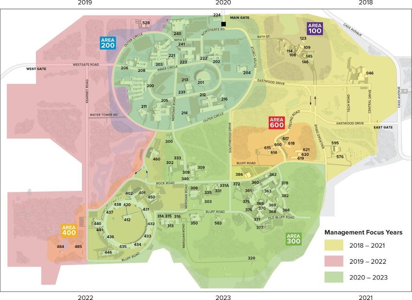
18 Argonne National LaboratoryNATURAL RESOURCES MANAGEMENT PLAN, 2018–2020 7.0 Implementation and Monitoring This plan divides the lab into three generally equal sections for focusing annual management resources and to implement an adaptive management procedure. Site work is annually conducted by contractors or Argonne grounds personnel at the direction of the laboratory’s Natural Resources Manager. After two years, actions conducted are evaluated using floristic assessments of the predominant vegetation and changes that have occurred. A report is then prepared with observations and recommendations for the next management cycle. The reports, historically titled “Site Ecology Reports,” contain recommendations that are then used in subsequent years for revising or updating management plans. In this manner, in any given year at least a third of the site receives management action, a third is allowed to respond to the previous year’s action, and a third is being assessed for actions performed two years previous. This process rotates to one of the three areas every year (Figure 15). FIGURE 15 Three-year management planning units. Argonne National Laboratory 19
NATURAL RESOURCES MANAGEMENT PLAN, 2018–2020

8.0 References
Note: Argonne publications referenced below will be available through the laboratory’s Natural
Resources Program website at www.anl.gov/sustainability/natural-resources-program.

1. “Facility and Infrastructure Strategic Investment Plan,” Argonne National Laboratory,
   Lemont, IL (2016).

2. “Natural Resources Management Plan (NRMP) 2015–2017,” Argonne National Laboratory,
   Lemont, IL (2015).

3. “Natural Resources Management Plan (NRMP) 2012–2014,” Argonne National Laboratory,
   Lemont, IL (2012).

4. DOE Order 430.1C, “Real Property Asset Management,” Section 4 Requirements. Available
   at https://www.directives.doe.gov/news/0430.1C-new.

5. DOE Order 430.1C, “Real Property Asset Management,” Section 4 Requirements, Part a,
   Sub-section 1, Sub-part b. Available at https://www.directives.doe.gov/news/0430.1C-new.

6. Wilhelm, G., and L. Masters, “Floristic Quality Assessment, Revised,” Conservation
   Research Institute, Lombard, IL (1995). Available at
   http://www.conservationresearchinstitute.org/assets/chicagoareafqa.pdf.

7. “Argonne National Laboratory Wetland Management Implementation Plan,”
   ANL/EQO/Wetlands-2007/1. Argonne National Laboratory, Lemont, IL (2007).

20                                                                   Argonne National Laboratory
NATURAL RESOURCES MANAGEMENT PLAN, 2018–2020

Appendix A: Plant Communities of the Argonne Site
The 1,500-acre Argonne site includes approximately 1,000 undeveloped areas, many of which
support native plant communities. Prior to European settlement of the region, the types of plant
communities present on what is now the Argonne site were primarily open savanna/prairie and
savanna, with smaller areas of woodland and forest,(1) on silt loam and silty clay loam soils.(2) All
of these communities included at least some trees, primarily oaks (Quercus spp.). Prior to federal
acquisition of the land in 1946, most of the Argonne site was in agricultural use, both for crop
production and livestock grazing. Fire suppression began with settlement around 1840. During
this time, the remnant natural areas were likely used for grazing as well as sources of timber.

Many natural areas were lost as trees were cut and fields were plowed. Populations of white-
tailed deer (Odocoileus virginianus) increased considerably following the establishment of
Argonne, with subsequent effects on plant communities by selective herbivory. Argonne
construction activities and other land disturbances began in the late 1940s and have generally
been concentrated in several areas scattered throughout the site. As a result of past land uses,
natural areas on the site are considerably fragmented and disturbed, although there are still a
number of relatively large undisturbed areas.

Plant communities of the Argonne site were surveyed and mapped in 1998 and have been
surveyed consistently since 2011. The community maps have been entered into the Argonne
Geographic Information System (GIS) and the dominant species of each plant community
recorded in a database integrated with the GIS. The survey was repeated in 2003, including the
diameters at breast height (dbh) of selected trees, and the GIS files were updated. Comprehensive
species lists for many of the plant communities have been developed to include all known
species in each community. For these communities, a Floristic Quality Index has been calculated
using the protocol described in Swink and Wilhelm (1994).(3) This index allows for the
identification of high-quality remnant natural areas — it also provides a measure of the overall
quality or degradation of Argonne plant communities. All of the plant communities on the
Argonne site have been degraded to varying extents by factors such as fire suppression, former
grazing of livestock, hydrologic alterations, establishment of invasive species, herbivory by deer,
and construction. However, a number of high-quality natural communities still occur on the site.
Plant communities, which are classified based on the Chicago Wilderness community
classification system, are described below.

Woodlands on the Argonne site include a wide range of habitat types, successional stages, and
floristic quality. These remnant natural communities are the most common on the site. Canopy
openness of mature native trees ranges from approximately 50% to nearly 100%, with dominant
species consisting of white oak (Quercus alba), black oak (Q. velutina), bur oak
(Q. macrocarpa), and red oak (Q. rubra). A large number of these trees exceed 80 cm dbh and
150 years in age. The larger trees (over 100 cm dbh) likely predate European settlement of the
area. A variety of secondary species, such as shagbark hickory (Carya ovata) and black cherry
(Prunus serotina), also commonly occur in these woodlands. Several woodlands support highly

Argonne National Laboratory                                                                        A-1
NATURAL RESOURCES MANAGEMENT PLAN, 2018–2020

conservative species (species that are found most often in high-quality, undisturbed native
habitats) such as large-flowered trillium (Trillium grandiflorum) and wood sandwort (Arenaria
lateriflora). Because of the presence of many younger fire-intolerant native trees, such as black
cherry, the canopies of these woodlands are closed (100%). Non-native invasive species, such as
common buckthorn (Rhamnus cathartica), a small- to medium-sized tree, and shrub honeysuckle
(Lonicera spp.), have become established in all of the woodlands on the Argonne site, in many
cases forming a dense thicket with few native herbaceous species. Soil erosion sometimes occurs
beneath these thickets. Other invasive species often present are oriental bittersweet (Celastrus
orbiculatus) and garlic mustard (Alliaria petiolata). Reproduction and recruitment of the canopy
oak species seldom occur in woodland communities of the site. Infestations of gypsy moths
(Lymantria dispar) have resulted in temporary defoliation of canopy and understory trees. The
woodland communities on the Argonne site include dry-mesic silt loam woodland, mesic silt
loam woodland, and wet-mesic silt loam woodland. Some woodland communities contain vernal
pools or basin marsh communities.

Savanna communities are also common on the Argonne site. The dominant trees of these
remnant natural communities are generally bur oak, white oak, or black oak, or some
combination of these species. The canopy of mature trees averages 10% to 50%, with many pre-
settlement trees present. These communities tend to have greater average tree diameters than the
woodlands onsite, but support fewer highly conservative species. However, a large number of
younger trees, particularly of Hill’s oak (Quercus ellipsoidalis), now creates a nearly closed
canopy. As in the woodland communities, invasive species have become established in all of the
savanna communities on the Argonne site. Soil erosion occurs in some areas where invasive
species have formed dense thickets. Much of Argonne’s 200 Area includes remnant savanna
communities in which the understory has been replaced with turf grasses. The reproduction and
recruitment of the canopy oak species are generally absent from the savanna communities. At
times, infestations of gypsy moths have resulted in the temporary defoliation of canopy and
understory trees in some savannas on the Argonne site. The savanna communities on the
Argonne site include dry-mesic silt loam savanna, mesic silt loam savanna, and wet-mesic silt
loam savanna. Some savanna communities contain vernal pools or basin marsh communities.

Stands of jack pine (Pinus banksiana), white pine (Pinus strobus), or red pine (Pinus resinosa)
were planted in the 1950s to provide an acceptable plant cover on previously cultivated fields
that had become weedy following abandonment. Although these pine species are native to the
Chicago region, they are not known to be part of DuPage County natural communities, and do
not constitute a native plant community. Other plantations of hardwoods were also planted in the
same period. Patches of walnut (Juglans nigra), sweet gum (Liquidambar syraciflua), and ash
(Fraxinus sp.), among others, remain and have demonstrated succession or have become slightly
degraded. These sites can be regarded as mid-period successional communities and managed
toward oak/hickory woodland or savannah; however, most have an understory of unassociated
woody species, particularly of invasive buckthorn and honeysuckle.

A number of areas are classified as unassociated vegetation. These areas support a variety of
weedy native and non-native trees, such as box elder (Acer negundo), green ash (Fraxinus

A-2                                                                   Argonne National Laboratory
NATURAL RESOURCES MANAGEMENT PLAN, 2018–2020

pennsylvanica subintegerrima), black cherry, common buckthorn, and black locust (Robinia
pseudoacacia). These communities have generally become established on former agricultural
fields and do not progressively develop into a successive community where dominant species
(often long-lived, as in trees) support highly diverse and regular assemblages of plant species.
Agricultural field soils are highly disturbed and only remotely resemble the parent soil. That soil
was formed and matured by the influence of successive plant communities over time; hence,
opportunist weedy species are more capable of invading and perpetuating populations in
disturbed field soils over the same period of time that successional plant communities would
occur. Management can direct successional processes toward native prairie or woodland
establishment with restoration best-management practices.

Dominant grassland communities on the site generally have an invasive shrub component and
are classified as unassociated grasses and forbs. These communities have become established on
former agricultural fields. Most of the grasslands are primarily composed of non-native, cool-
season grasses, such as orchard grass (Dactylis glomerata), tall fescue (Festuca elatior), and
Hungarian brome (Bromus inermis), with occasional native forbs, such as wild bergamot. These
communities also include the woody invasive species common buckthorn and honeysuckles, as
well as herbaceous non-native invasive species such as crown vetch, field thistle (Cirsium
arvense), and cut-leaved teasel (Dipsacus laciniatus). In many areas, these latter species are the
dominant species, with few other species present.

There are a few areas that could be considered prairie communities on the Argonne site, but
these lack a complex of highly conservative species. The native species present tend to be forbs,
such as Deam’s rosinweed (Silphium integrifolium deamii), prairie dock (Silphium
terebinthinaceum), wild bergamot (Monarda fistulosa), and yellow coneflower (Ratibida
pinnata). However, Indian grass (Sorghastrum nutans) and big bluestem (Andropogon gerardii)
occur in several areas. Non-native species are common in these communities, and several, such
as crown vetch (Coronilla varia), are invasive. The largest prairie community on the Argonne
site, located in southwestern portion of the site, is approximately 10 acres in size. However, most
or all of this community was possibly planted since the establishment of Argonne. The prairie
communities on the Argonne site include dry-mesic silt loam prairie, mesic silt loam prairie, wet-
mesic silt loam prairie, and wet silt loam prairie.

Wetlands are the habitat with the most regulation both here and in the nation, and have
physiographic connections to all other habitats. Particular focus is directed to wetlands and
adjacent uplands to meet or preserve natural assets that meet or may serve regulatory
requirements.

Wetlands on the Argonne site range from basin marsh and wet prairie to vernal pools. These
wetlands represent a variety of types, including (1) floodplain or riparian wetlands; (2) forested
wetlands; and (3) marshes, dominated by cattails, grasses, sedges, and rushes. Several high
quality, relatively undisturbed wetlands support unusual plant species or high species diversity.
Some of the wetlands are of relatively recent origin and have been formed as a result of human
activities. Many of these have degraded plant communities with relatively weedy species and

Argonne National Laboratory                                                                      A-3
NATURAL RESOURCES MANAGEMENT PLAN, 2018–2020

low species diversity. These are dominated by cattail (Typha spp.), common reed (Phragmites
australis), or reed canary grass (Phalaris arundinacea). Purple loosestrife (Lythrum salicaria) is
also common in several wetlands. Disturbance, pollution, alteration of natural hydrologic
regimes, and increased sedimentation generally favor the colonization and continued spread of
these invasive species.

Argonne completed a site-wide wetland delineation in 1993. All wetlands present on site were
identified and mapped following the 1987 Army Corps of Engineers Wetlands Delineation
Manual. The delineation map shows the extent of all wetlands present at Argonne. Thirty-five
individual wetland areas were identified; their total area is approximately 20 ha (50 acres). A
compensatory site, Wetland R, was created for wetland losses caused by the building of the
Advanced Photon Source. In 2011, the Corps of Engineers stated this mitigation wetland was
successfully established and requested that continuous monitoring be conducted. Argonne has
also restored and improved several acres of high-quality wetland in the 400 Area (Wetland 302)
by disabling a drainage tile network installed when the land was a farm.

References:

1. Bowles, M., J. McBride, and L. Bell, “Landscape Vegetation Pattern, Composition &
   Structure of DuPage County, Illinois, as Recorded by the U.S. Public Land Survey
   (1821-1840)” (1998).

2. Soil Conservation Service, “Soil Survey of DuPage and Part of Cook Counties, Illinois”
   (1979). Available at
   https://www.nrcs.usda.gov/Internet/FSE_MANUSCRIPTS/illinois/dupage_cookIL1979/
   dupage.pdf.

3. Swink, F. and G. Wilhelm, “Plants of the Chicago Region,” Indiana Academy of Science,
   Indianapolis, IN (1994).

A-4                                                                    Argonne National Laboratory
NATURAL RESOURCES MANAGEMENT PLAN, 2018–2020

Appendix B: Ecosystem Management Units

EMU 01: This unit includes mesic savanna, in two small individual stands. Construction of the
chilled water facility has eliminated approximately half of the western stand. The dominant tree
species of the canopy in both stands are bur oak (Quercus macrocarpa) and white oak (Q. alba).
This unit includes black walnut (Juglans nigra) trees planted by Argonne in 1954. The west
boundary of this unit is formed by a hedgerow of large osage orange (Maclura pomifera) trees.
The savanna communities contain several species with a C=8: downy green sedge (Carex
swannii), narrow-leaved oval sedge (Carex tenera), flowering dogwood (Cornus florida), flat-
stemmed spike rush (Eleocharis compressa), and spinulose shield fern (Dryopteris spinulosa).
Redbud (Cercis canadensis), present in this unit, has a C=10. Common stiff sedge (Carex
tetanica), which has a C=9, occurred in the western stand in the area of the chilled water facility.
A basin marsh is located between the two oak stands. This wetland is a naturally occurring
wetland that is drained by a culvert under the Argonne boundary fence. Although this wetland is
dominated by narrow-leaved cattail (Typha angustifolia), it supports a high diversity of native
plant species. The floristic quality of this unit is moderate.

EMU 02: This unit primarily consists of mesic savanna. The dominant tree species of the canopy
are bur oak and white oak. Two small wetland areas, supported by building drainage, are
dominated by narrow-leaved cattail. An area of unassociated grasses and forbs in the western
portion of this unit is composed nearly entirely of non-native species. The savanna had been

Argonne National Laboratory                                                                      B-1
NATURAL RESOURCES MANAGEMENT PLAN, 2018–2020

regularly mowed until 2005. A population of buckthorn became established and was cut once, in
2015. The floristic quality of this unit is low to moderate.

EMU 03: This unit primarily consists of pine plantations, including red pine (P. resinosa), white
pine (P. strobus), and jack pine (P. banksiana). Some areas that had been planted with jack pine,
which have been in decline in recent years, are now considered unassociated woody growth, with
black cherry (Prunus serotina) composing most of the tree canopy. Conservative species
observed in this unit include mockernut hickory (Carya tomentosa), C=10; rattlesnake master
(Eryngium yuccifolium) and marsh blue grass (Poa palustris), both C=9; and lady fern (Athyrium
filix-femina), downy green sedge, spinulose shield fern, sensitive fern (Onoclea sensilibis), and
chinquapin oak (Quercus muhlenbergii), all C=8. A large wetland that is primarily a basin marsh
is located within this unit and is dominated by narrow-leaved cattail, and non-natives reed canary
grass (Phalaris arundinacea) and common reed (Phragmites australis). Larvae of the Hine’s
Emerald Dragonfly, a federally and state-listed endangered species, was discovered in this
wetland. The northern portion of this wetland includes a segment of Wards Creek, a tributary of
Sawmill Creek, however, much of the channel within this wetland had been excavated during
development of the Argonne site to convey surface water from the 800 and 200 Areas. This
wetland is drained by a culvert under the Argonne boundary fence. The floristic quality of this
unit is low to moderate.

EMU 04: This unit is comprised of the Argonne 800 Area, which had previously contained
numerous temporary buildings and storage areas. Conservative species observed in this unit
include Pinus resinosa (C=10), sweet grass (Hierochloe odorata) (C=9), and narrow-leaved oval
sedge (C=8). The entire unit has been significantly disturbed and supports a mosaic of upland
and wetland plant communities. Wetland development is associated with compacted soils,
excavations, and altered drainage patterns. Although the dominant species in these communities
are non-native, a variety of disturbance-tolerant native species are present. The floristic quality
of this unit is low to moderate.

EMU 05: This unit includes the Argonne landfill area. The landfill cover was completed in 1993
and supports a herbaceous community of mostly non-native grasses. A basin marsh is located
along the western boundary fence line and is contiguous with a large marsh in Waterfall Glen
Forest Preserve. Dominant species in the marsh are common reed, narrow-leaved cattail, and
non-natives reed canary grass and common reed. A small remnant of a jack pine plantation is
located in the southwest corner of this unit and includes deciduous woody species, primarily
non-natives. The floristic quality of this unit is low.

EMU 06: This unit primarily consists of white pine and jack pine plantations. Much of the area
that had been planted with jack pine is now becoming dominated by deciduous woody species,
primarily non-natives. Sweetgum (Liquidambar styraciflua), planted by Argonne in 1954, occurs
in the northern section of this unit. Conservative species observed in this unit include lady fern,
downy green sedge, narrow-leaved oval sedge, spinulose shield fern, and sensitive fern, all C=8.
A basin marsh is located within this unit and supports a wide variety of mostly native species.
The northern portion of the wetland includes a drainage ditch, conveying water to a culvert under

B-2                                                                     Argonne National Laboratory
NATURAL RESOURCES MANAGEMENT PLAN, 2018–2020

Kearney Road. The northernmost portion of this unit consists of an area of unassociated grasses
and forbs composed nearly entirely of non-native species. The floristic quality of this unit is low
to moderate.

EMU 07: This unit primarily consists of unassociated woody growth. The dominant tree species
vary throughout the unit and include the native species box elder (Acer negundo), green ash
(Fraxinus pennsylvanica subintegerrima), and eastern cottonwood (Populus deltoides). Green
ash was planted by Argonne in this location in 1954. Conservative species observed in this unit
include great bladderwort (Utricularia vulgaris) (C=9), and narrow-leaved oval sedge, pale
purple coneflower (Echinacea pallida), false pennyroyal (Isanthus brachiatus), sensitive fern,
and white water crowfoot (Ranunculus longirostris), all C=8. Portions of this unit had been
disturbed in the past by facility construction and demolition. Small degraded remnants of mesic
prairie occur in this unit, primarily along Kearney Road and near the intersection of Watertower
and Outer Circle Roads. Numerous small wetlands occur within this unit, primarily supporting
native sedges (Carex spp.) and bulrush (Scirpus spp.). In recent years, a significant wet prairie
community has developed west of Kearney Road, likely the result of drain tile failure. A basin
marsh with a variety of native sedges and forbs is located in the western section of the unit. A
wetland in the eastern portion of the unit is supported by drainage from nearby watertowers and
dominated by narrow-leaved cattail and common cattail (Typha latifolia). The floristic quality of
this unit is low to moderate.

EMU 08: This unit primarily consists of unassociated grasses and forbs, composed nearly
entirely of non-native species, with non-native shrubs predominating over much of the area.
Marsh blue grass (Poa palustris) (C=9) occurs in this unit. Areas of this unit had been disturbed
in the past by facility construction and demolition. This unit includes a basin marsh. A portion of
this wetland is naturally occurring, however, much of the wetland had been excavated during
development of the Argonne site to convey surface water from the 800 Area. Dominant species
include narrowleaved cattail, sandbar willow (Salix interior), and common reed. The floristic
quality of this unit is low to moderate.

EMU 09: This unit consists of dry-mesic savanna. The dominant tree species of the canopy is
black oak (Quercus velutina). Green ash and black walnut planted in this location by Argonne in
1954 occur in this unit. A variety of native herbaceous species is present under the oak canopy,
but sparse in coverage. A drainage ditch along the eastern margin of the unit conveys surface
water north from the 800 Area and supports a wetland community of shrubs and herbaceous
species. The floristic quality of this unit is low to moderate.

EMU 10: This unit consists of dry-mesic savanna. The dominant tree species of the canopy are
black oak and bur oak. This savanna is isolated, being surrounded by mowed lawns. A wide
variety of native shrubs and herbaceous species are present. The floristic quality of this unit is
moderate.

EMU 11: This unit includes mesic savanna, in two stands separated by Outer Circle Road. The
dominant tree species of the canopy are bur oak and white oak. This unit includes black walnut

Argonne National Laboratory                                                                      B-3
You can also read