Hungry Lion Resource Management Project - Decision Notice United States Department of Agriculture
←
→
Page content transcription
If your browser does not render page correctly, please read the page content below
United States Department of Agriculture

Hungry Lion Resource
Management Project
Decision Notice

Lion Lake, Hungry Horse-Glacier View Ranger District

         Flathead National Forest, Hungry Horse-Glacier View Ranger District   August 2018
For More Information Contact:
                                             Rob Davies – District Ranger
                                        Sarah Canepa – Planning Team Leader
                                      Hungry Horse – Glacier View Ranger District
                                       10 Hungry Horse Drive, P.O. Box 190340
                                              Hungry Horse, MT 59919
                                                   (406) 387-3800

In accordance with Federal civil rights law and U.S. Department of Agriculture (USDA) civil rights regulations and policies,
the USDA, its Agencies, offices, and employees, and institutions participating in or administering USDA programs are
prohibited from discriminating based on race, color, national origin, religion, sex, gender identity (including gender
expression), sexual orientation, disability, age, marital status, family/parental status, income derived from a public assistance
program, political beliefs, or reprisal or retaliation for prior civil rights activity, in any program or activity conducted or
funded by USDA (not all bases apply to all programs). Remedies and complaint filing deadlines vary by program or incident.
Persons with disabilities who require alternative means of communication for program information (e.g., Braille, large print,
audiotape, American Sign Language, etc.) should contact the responsible Agency or USDA’s TARGET Center at (202) 720-
2600 (voice and TTY) or contact USDA through the Federal Relay Service at (800) 877-8339. Additionally, program
information may be made available in languages other than English.
To file a program discrimination complaint, complete the USDA Program Discrimination Complaint Form, AD-3027, found
online at http://www.ascr.usda.gov/complaint_filing_cust.html and at any USDA office or write a letter addressed to USDA
and provide in the letter all of the information requested in the form. To request a copy of the complaint form, call (866) 632-
9992. Submit your completed form or letter to USDA by: (1) mail: U.S. Department of Agriculture, Office of the Assistant
Secretary for Civil Rights, 1400 Independence Avenue, SW, Washington, D.C. 20250-9410; (2) fax: (202) 690-7442; or (3)
email: program.intake@usda.gov.
USDA is an equal opportunity provider, employer and lender.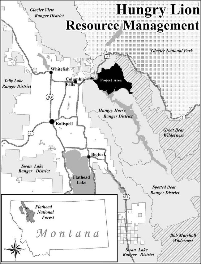
Hungry Lion Resource Management Project
Contents
I. Summary of Decision .................................................................................................................................2
II. Purpose and Need for Action ....................................................................................................................5
III. Public Involvement ..................................................................................................................................5
IV. Issues .......................................................................................................................................................6
V. Alternatives Studied in Detail...................................................................................................................6
VI. Alternatives Not Studied in Detail ..........................................................................................................7
VII. Decision .................................................................................................................................................9
VIII. Rationale for the Decision ..................................................................................................................13
IX. Finding of No Significant Impact ..........................................................................................................19
X. Findings Related to Other Laws and Regulations ..................................................................................29
XI. Pre-Decisional Administrative Review Process ....................................................................................36
XII. Contact .................................................................................................................................................38
Appendix 1 – Details of the Selected Alternative .......................................................................................39
Appendix 2 - Design Features .....................................................................................................................50
List of Tables
Table 1. Management activities in the selected alternative .........................................................................10
Table 2. Modifications made in the selected alternative .............................................................................10
Table 3. Comparison of alternatives ............................................................................................................12
Table 4. Comparison of alternatives by measurement indicators ................................................................16
Table 5. Vegetation treatments ....................................................................................................................39
Table 6. Vegetation treatment units.............................................................................................................43
Table 7. Historical road templates to be classified as intermittent stored service .......................................46
Table 8. Road management .........................................................................................................................47
Table 9. Aquatic improvements ..................................................................................................................47
Table 10. Vegetation units requiring winter harvest ...................................................................................50
Table 11. Unit specific design features for scenic resource ........................................................................55
List of Figures
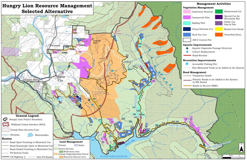
Figure 1. Project area vicinity map................................................................................................................4
iDecision Notice Hungry Lion Resource Management Project
I. Summary of Decision
The Hungry Lion Resource Management Project (Hungry Lion) includes different types of
resource management activities on a portion of the Hungry Horse-Glacier View Ranger District of
the Flathead National Forest, Flathead County, Montana. The project area includes the
communities of Hungry Horse, Martin City, and Coram stretching east to the Great Bear
Wilderness and south to the Hungry Horse Reservoir (see figure 1 – project area vicinity map).
The project area is approximately 37,090 acres in size and all project activities will occur on
National Forest System (NFS) lands.
After careful consideration of the potential effects of management activities analyzed and
documented in the Hungry Lion Resource Management Project Updated Environmental
Assessment (Hungry Lion Updated EA, August 2018) and public comments received in response
to the Hungry Lion EA, I have decided to implement a selected alternative that combines
elements of both alternative 2 and alternative 3, as analyzed in the Hungry Lion Updated EA
(August 2018).
A summary of the actions in my decision include the following:
Vegetation treatments on approximately 4,177 acres to maintain or improve the diversity
and health of forest vegetative communities; reduce the risk to wildland firefighters and
residents of the wildland-urban interface should a fire occur; and maintain or improve
timber productivity on suitable lands and provide a variety of wood products to the local
economy.
o Approximately 2,614 acres of harvest are expected to produce a commercial
product.
Approximately 1,304 acres of treatments will be within the wildland-
urban interface to reduce hazardous fuels near private property and
communities.
Approximately 184 acres of treatment will be implemented and
monitored as part of the Adaptive Silviculture for Climate Change
research project.
o An estimated 804 acres of treatments will be non-commercial and includes
activities such as sapling thin, understory removal, and public post and pole.
o Approximately 759 acres of treatments will be conducted through prescribed
burning with no associated mechanized activity.
Harvest activities will require the construction of approximately 3.8 miles of temporary
road, which will be fully rehabilitated following project activities, and the reconstruction
of 4.8 miles of historical road which will be placed into intermittent stored service (ISS)
status following use and treated to meet the definition of reclaimed in accordance with
amendment 19 of the Flathead National Forest Plan.
Up to 12 culverts will be replaced, repaired, or maintained, 6 aquatic organism passage
(AOP) structures will be installed, and 1.4 miles of road in upper Emery Creek will be
2Hungry Lion Resource Management Project Decision Notice
rerouted to restore hydrologic processes, water quality, and aquatic habitat by reducing
road/stream interaction.
Approximately 50.9 miles of road will be evaluated for best management practices
(BMP) and applied as needed.
Approximately 12 miles of historical and social trail will be added to the NFS trail
system to create a more sustainable recreation opportunity that meets Forest Service
standards.
A fishing pier will be constructed near the South Lion Lake day use area and parking
improvements will occur at the North Lion Lake trailhead to better accommodate
increasing use and horse trailer traffic.
With this decision, I am authorizing an amendment to the Flathead Forest Plan to authorize a one-
time 30-day entry into grizzly bear security core to replace, repair, or maintain high-risk culverts
located on NFS Road 1614. More information on this forest plan amendment can be found on pp.
29-30 of this Decision Notice.
This decision notice includes the details of the decision, the rationale behind the decision, and the
finding of no significant impact (FONSI) that allowed me to choose an EA as the appropriate
level of analysis. This decision also includes two appendices and one map to provide more
information about the decision.
3Decision Notice Hungry Lion Resource Management Project
Figure 1. Project area vicinity map
4Hungry Lion Resource Management Project Decision Notice
II. Purpose and Need for Action
The need for the Hungry Lion Resource Management Project was derived from the differences
between the existing condition of specific resources in the project area and the desired landscape
condition. The Flathead National Forest Land and Resource Management Plan (forest plan)
provides the primary management direction related to the goals and desired condition of these
resources. The following purposes for the proposed project addresses these differences:
• Maintain or improve the diversity and health of forest vegetative communities.
• Reduce the risk to wildland firefighters and residents of the wildland-urban interface
should a fire occur.
• Maintain or improve timber productivity on suitable lands and provide a variety of wood
products to the local economy.
• Maintain, improve, or restore hydrologic processes, water quality, and aquatic habitat
throughout the project area by reducing road/stream interaction.
• Increase recreational opportunities and improve visitor safety at developed and dispersed
recreation sites.
The purpose and need for the project is discussed in detail in the Hungry Lion Updated EA
(August 2018) on pp. 4-8.
III. Public Involvement
Request for information
On August 31, 2016, the district sent out a letter and map of the project area requesting
information from landowners in the project area and other interested members of the public to
share information about the project area and identify what types of management activities they
would like to see in the project area. This mailing was sent to approximately 879 individuals,
organizations, businesses, and agencies (project file exhibit A-22). The district received 18
responses to this request for information, which were used to develop management proposals for
the project area (project file exhibit A-1 through A-19).
Proposed action
On November 18, 2016, the district sent out the proposed action for the Hungry Lion Resource
Management Project to local landowners and interested members of the public to ask for site-
specific comments on proposed management activities (project file exhibit B-1). The district sent
out approximately 612 packets of maps, project information, details about a public open house,
and instructions on how to comment (project file exhibit B-1). The district met with several
landowners in person to discuss their concerns and received 134 written comments on the
proposed management activities (project file, section C).
Open house
The district held a public open house on December 8, 2016, at the Hungry Horse-Glacier View
Ranger Station, from 4:00 – 7:00 pm. This served as an opportunity to provide information to the
5Decision Notice Hungry Lion Resource Management Project
public and allow people to ask questions to project team members about the activities proposed in
the Hungry Lion Project. Approximately 22 individuals attended the open house to discuss the
project area and proposed activities (project file exhibit D-2).
Environmental assessment
Interested members of the public were informed of the availability of the Hungry Lion
Environmental Assessment on July 12, 2017. This list included all individuals and organizations
that commented on the proposed action and people that expressed an interest in remaining on the
contact list for the Hungry Lion Project. A legal notice appeared in the Daily Inter Lake on July
13, 2017, and marked the beginning of the 30-day comment period. The district hosted a field trip
in the project area on July 26, 2017, which was attended by three members of the public.
The district received a total of 83 comments on the environmental assessment. A summary of the
written comments received on the project and the Forest Service response to these comments
were included in appendix 3 of the Hungry Lion Draft Decision Notice (May 2018). All
comments received were fully considered in this decision.
IV. Issues
Based upon the issues identified during public scoping, the interdisciplinary team and I identified
the following key issues, for which two action alternatives were developed:
• Potential conflict between wildlife and recreationists;
• Potential effects of culvert replacement or removal on NFS Road 1614 in grizzly bear
security core;
• Potential effects of vegetation management to wildlife habitat; and
• Potential effects of temporary roads and historical road templates.
These issues were used to develop alternatives 3 and 4, which make modifications to address each
issue. These issues are described in detail in the Hungry Lion Updated EA (August 2018) on pp.
11-12.
V. Alternatives Studied in Detail
Alternative 1
This alternative represents the existing condition in the Hungry Lion Project Area. Under this
alternative, none of the activities proposed for the Hungry Lion Project would occur. No fuels
reduction or forest health activities would occur under this alternative. No roads would be added
to the system or re-routed to improve aquatic habitat and function. No culverts or AOP structures
would be replaced or installed. This alternative does not include thinning activities to improve
western white pine stands that were planted under previous decisions. Ongoing activities, such as
recreation, public firewood gathering, fire suppression, and normal road maintenance would
continue in this alternative. Ongoing processes, such as the spread of invasive species, fire, and
forest insect and disease pathogens would continue to impact the project area over time. Activities
identified in chapter 3 of the Hungry Lion Updated EA (August 2018) as current and foreseeable
actions would continue to occur. Alternative 1, the no-action alternative, serves as a point of
6Hungry Lion Resource Management Project Decision Notice
comparison between the existing condition and the potential effects of the three action
alternatives.
Alternative 2
Alternative 2 was designed to meet the purpose and need for the project and is similar to the
proposed action that was scoped with the public in December 2016. Alternative 2 proposes
several different types of vegetation management activities to achieve the purpose and need.
These treatments include silviculture prescriptions for commercial harvest on 3,243 acres; non-
commercial activities on 893 acres; and prescribed burning without harvest activities on 759
acres. To accomplish these vegetation treatments, alternative 2 proposes to construct 6.7 miles of
temporary road; add 7.6 miles of historical road template back to system for use during project
activities, then placed into ISS; and approximately 58.6 miles of BMPs on haul roads. Alternative
2 proposes to reroute 1.4 miles of system road improve aquatic habitat, maintaining, and/or
replace, repair, or maintain 12 road culverts and install 6 aquatic organism passage structures to
reduce road stream interaction. This alternative proposes to add approximately 12 miles of
historical and social trails to the NFS trail system for maintenance and management and other
activities to improve recreational facilities at Lion Lake day use areas.
Alternative 3
Alternative 3 was designed to address public concern about potential effects to wildlife from
proposed management activities. Alternative 3 proposes silviculture prescriptions for commercial
harvest on 2,226 acres, non-commercial activities on 433 acres, and prescribed burning without
harvest activities on 759 acres. To accomplish these vegetation treatments, Alternative 3 proposes
to construct 2.8 miles of temporary road; add 4.2 miles of historical road template back to system
for use during project activities, then placed into ISS; and approximately 58.6 miles of BMPs on
haul roads. Alternative 2 proposes to reroute 1.4 miles of system road improve to aquatic habitat,
maintain and/or replace 3 road culverts, and install 6 aquatic organism passage structures to
reduce road stream interaction. This alternative proposes to decommission and rehabilitate
approximately 12 miles of historical and social trails and proposes other activities to improve
recreational facilities at Lion Lake day use areas.
Alternative 4
Alternative 4 was designed to address public comment that asked the Forest Service to consider
an alternative that does not construct temporary roads or use historical road template to conduct
project activities. Alternative 4 proposes silviculture prescriptions for commercial harvest on
1,333 acres; non-commercial activities on 886 acres; and prescribed burning without harvest
activities on 759 acres. Approximately 48.8 miles of BMPs would be implemented on haul roads.
Alternative 4 proposes to reroute 1.4 miles of system road to improve aquatic habitat, maintain
and/or replace 3 road culverts, remove 10 culverts, and install 6 aquatic organism passage
structures to reduce road-stream interaction. This alternative proposes to add approximately 12
miles of historical and social trails to the NFS trail system for maintenance and management and
other activities to improve recreational facilities at Lion Lake day use areas.
VI. Alternatives Not Studied in Detail
This section discusses alternatives that were considered, but not given detailed study. These
alternatives were proposed in public comment on the proposed action, but the interdisciplinary
7Decision Notice Hungry Lion Resource Management Project
team determined that they did not need to be studied in detail for the reasons explained in the
following narrative.
Include an alternative that does not require approval for clearcuts over 40 acres in size that
will negatively affect wildlife
Public comment asked that an alternative be developed that did not propose regeneration harvest
for units greater than 40 acres in size or propose vegetation management in grizzly bear security
core during the denning season. The interdisciplinary team considered these comments and
developed alternatives to look at effects to wildlife from the proposed activities. Alternative 3
eliminated vegetation management units that affected potential habitat for fisher, lynx foraging
habitat, and reduced the influence to old growth stands, but determined that units 30, 32, and 59
(which are over 40 acres in size) had minimal effects to the measurement indicators identified for
wildlife habitat. Design features were also developed to ensure that no point in the unit would be
greater than 600 ft to provide adequate hiding cover for grizzly bears and other wildlife species.
The team determined that alternative 3 and the design features implemented across all action
alternatives would meet the public comment received and that the effects analysis would show
how units greater than 40 acres would affect wildlife and wildlife habitat. I received approval for
these openings from the regional forester on January 30, 2018 (project file exhibit I-9c).
Add trails to NFS trail system, but prohibit mountain bike use
The majority of public comment received on the Hungry Lion Proposed Action was related to
mountain bike use of the proposed NFS trails. Some commenters asked that the historical trails be
decommissioned and rehabilitated, which was proposed in alternative 3. Other commenters
wanted to see the trails managed and maintained for all nonmotorized user groups, which was
proposed in alternatives 2 and 4. Some commenters asked the district to manage and maintain
trails, but prohibit mountain bike use on these trails to reduce conflicts between different user
groups such as hikers and equestrian users. The district recognizes potential for conflict between
user groups can exist on NFS trails, but is proposing to design the Desert Mountain and Lion Hill
trails to improve sight distances and to conduct outreach and education efforts at trailheads to
raise awareness to recreationists of the potential for wildlife conflicts and conflicts between user
groups.
Trail design changes that increase sight distances, will reduce the potential for surprise conflicts
between user groups. Educating people about the importance of making noise while they recreate
will allow both wildlife and other users to hear recreationists on the trail. The design features
(appendix 2) provide more information about efforts to reduce the potential for conflict related to
the proposed system trails. The district will conduct these changes in partnership with user
groups, to help design trails that will reduce conflict between user groups. For these reasons, the
responsible official did not want to propose the prohibition of any specific nonmotorized user
groups from the proposed trails in this project.
Decommission NFS Road 1614, instead of replacing culverts
Public comment asked that instead of proposing to replace culverts on NFS Road 1614, in grizzly
bear security core, that the district instead decommission this road. The district bermed this road
in the Firefighter DN (2009) to create grizzly bear security core habitat, but chose to leave the
road on the system with culverts in place to allow the continued use of an existing groomed
snowmobile trail system that was analyzed under the amendment 24 (2006) decision addressing
over-the-snow vehicle use. The Firefighter DN addresses this issue multiple times in response to
8Hungry Lion Resource Management Project Decision Notice
comments (project file exhibit V-2) and it is not the purpose of this project to revisit the decisions
made about snowmobile use in the project area.
In its bermed status, the road provides secure grizzly bear core habitat during the non-denning
season and continues to be part of a groomed snowmobile system that was approved under
amendment 24 to the forest plan. Maintaining this road on the system will also allow for future
vegetation management on lands included in the suitable timber base. Alternative 4 proposes to
remove the undersized culverts vs. replacing the culverts to reduce the need for long term
maintenance on a bermed road. This alternative would have similar effects to decommissioning
the road for wildlife and snowmobile grooming over time. For these reasons, the responsible
official determined that the best course of action would be to leave the road on the system but to
analyze different alternatives to address the concerns related to undersized culverts.
Decommission more roads in the project area
Public comment asked that the Hungry Lion project propose to decommission more roads in the
project area. When the Hungry Lion project was being developed, the need for further road
decommissioning or reclamation was not identified because past projects such as Paint Emery
(1999) and Firefighter (2009), which are located within the same Emery Firefighter bear
management subunit as Hungry Lion, included road decommissioning and reclamation to
improve security for grizzly bears. The decision for the Paint Emery project approved
approximately 116 miles of road reclamation and the Firefighter decision included 28.7 miles of
road decommissioning, some of which modified access management decisions made in Paint
Emery. When the Firefighter decision is fully implemented, the Emery Firefighter subunit will
meet motorized access densities and security core objectives from amendment 19 to the forest
plan (this amendment provides management direction for maintaining or improving security for
grizzly bears in a portion of the Flathead National Forest). The Hungry Lion project also occurs
in the Coram Lake Five grizzly bear subunit which has less than 75 percent national forest system
ownership (about 69 percent) and the amendment 19 objectives for open and total motorized
access density and security core do not apply and therefore no road reclamation or
decommissioning is required to meet forest plan direction.
Since the Emery Firefighter bear management subunit will meet all of the Amendment 19
objectives shortly, the responsible official did not see the need to include road decommissioning
in Hungry Lion. He believes there is an appropriate balance in the project area with the existing
road system providing access to the public and future vegetation management opportunities and
the existing well-functioning habitat for wildlife, fisheries, and other species. The responsible
official also believes that the forestwide travel analysis (project file exhibit R-16) and the project
level travel analysis (project file exhibit R-1) have identified the appropriate road system for the
project area to protect resources and provide for current and future forest management and are in
compliance with 36 CFR 212 (subparts A and B).
VII. Decision
As the responsible official for this project, I am authorizing the selected alternative, which
combines elements of both alternative 2 and alternative 3 to best address public comment
received on the EA and to balance the needs of different resources across the project area.
Management activities such as commercial thin, seed tree, shelterwood, group selection, sapling
thin, and prescribed burning would occur under the selected alternative. Associated temporary
road building and reconstruction of historical templates to access harvest units are included in this
9Decision Notice Hungry Lion Resource Management Project
decision, as are aquatic improvement activities, adding historical and social trails to the NFS trail
system, and recreational improvements at the Lion Lake day use areas.
The activities in my decision include the following activities:
Table 1. Management activities in the selected alternative
Management Activities Selected Alternative
Seed tree 899 acres
Shelterwood 45 acres
Group selection cut 53 acres
Commercial thin 1,483 acres
Shaded fuel breaks 57 acres
Special cut (recreation areas) 77 acres
Total commercial harvest 2,614 acres
Estimated volume 16,600 CCF
Sapling thin 608 acres
Understory removal 189 acres
Public use post & pole 7 acres
Total non-commercial harvest 804 acres
Prescribed burning (ecosystem burns) 759 acres
Roads to receive best management practices (haul routes) 50.9 miles
Historical roads to be added to the system in intermittent stored service 4.8 miles
Temporary roads 3.8 miles
Historical and social trail added to system 12 miles
Accessible fishing pier on Lion Lake 1 pier
Road reroute to improve aquatic habitat 1.4 miles
Culverts to be replaced, repaired, or maintained 12 culverts
AOP structures to be installed 6 structures
The selected alternative was developed by combining elements of alternative 2 and alternative 3
to reduce potential effects to different resources. These modifications include dropping all or a
portion of a unit, and in some cases modifying prescriptions. These units, as well as the rationale
behind the modifications, are indicated in Table 2, and described as changes made to alternative
2.
Table 2. Modifications made in the selected alternative
Unit Action Taken Acres Rationale
01 Dropped 11 Dropped because riparian area covered most of unit.
02 Dropped 26 Unit located in grizzly bear core
Modified unit Reduced acres to maintain cover for wildlife connectivity while
03 52
boundaries treating fuels adjacent to private property.
Modified unit Reduced acres to maintain cover for wildlife connectivity while
04 5
boundaries treating fuels adjacent to private property.
10Hungry Lion Resource Management Project Decision Notice
Unit Action Taken Acres Rationale
Modified prescription and area of proposed treatment to maintain
Modified
06 14 wildlife connectivity while reducing fuels adjacent to private
prescription
property
07 Dropped 18 Dropped to improve wildlife connectivity.
08 Dropped 11 Dropped due to visual concerns and infeasibility.
Modified Modified prescription to commercial thin to recruit old growth and
12 13
prescription maintain consistency with past treatments in adjacent stands.
16 Dropped 17 Dropped due to visual concerns
16A Dropped 4 Dropped due to visual concerns
22 Dropped 4 Dropped due to infeasibility
22A Dropped 8 Dropped due to infeasibility
Modified Prescription was changed from commercial thin to shaded fuel
26 9
Prescription break.
34 Dropped 19 Dropped to reduce effects of treatment adjacent to old growth.
34A Dropped 3 Dropped to reduce effects of treatment adjacent to old growth.
35 Dropped 13 Dropped due to infeasibility
35A Dropped 19 Dropped due to infeasibility
Modified Modified prescription to commercial thin to recruit old growth
40 29
prescription
43A Dropped 1 Dropped due to infeasibility
46 Dropped 17 Dropped due to infeasibility
50 Dropped 10 Dropped due to infeasibility
50A Dropped 2 Dropped due to infeasibility
52 Dropped 9 Dropped due to infeasibility
56 Dropped 51 Dropped due to infeasibility
56A Dropped 9 Dropped due to infeasibility
60 Dropped 22 Dropped due to infeasibility
61 Dropped 15 Dropped due to infeasibility
62 Dropped 18 Dropped due to infeasibility
62A Dropped 6 Dropped due to infeasibility
63 Dropped 6 Dropped due to infeasibility
82 Dropped 69 Dropped because riparian area covered most of unit.
85 Dropped 44 Dropped because riparian area covered most of unit.
87 Dropped 60 Dropped due to change in research objectives
87A Dropped 14 Dropped due to change in research objectives
88 Dropped 45 Dropped due to change in research objectives
88A Dropped 4 Dropped due to change in research objectives
Modified Prescription was changed to reduce fuels while capturing the value
100 22
prescription of commercial sized material.
11Decision Notice Hungry Lion Resource Management Project
Unit Action Taken Acres Rationale
Modified unit Reduced acres to maintain cover for wildlife connectivity while
102 56
boundaries treating fuels adjacent to private property.
Modified unit Reduced acres to maintain cover for wildlife connectivity while
104 38
boundaries treating fuels adjacent to private property.
My decision authorizes the use of skyline and ground-based logging systems to conduct
commercial harvest. Non-commercial activities such as understory removal will use mechanized
equipment in units where this was analyzed for and other work will occur by hand. All sapling
thinning will be conducted by hand. I am also authorizing mechanical and hand piling to occur in
units as methods of slash treatments. This decision includes appendix 1, which details the
prescription for each unit, the logging systems to be used, the slashing treatment, and whether
broadcast burning will occur in conjunction with other treatments. This decision authorizes a total
of 759 acres of prescribed burning to occur with no associated mechanized activity.
My decision also authorizes aquatic improvement activities. These activities include up to 12
culverts that will be replaced, repaired, or maintained. Six AOP structures will be installed on
streams in the project area. Approximately 1.4 miles of road in upper Emery Creek will be
rerouted in two separate locations to reduce road-stream hydrologic connectivity.
With this decision, I am authorizing an amendment to the Flathead Forest Plan to authorize a one-
time 30-day entry into grizzly bear security core to replace, repair, or maintain high risk culverts
located on NFS Road 1614.
My decision authorizes several types of road management activities. This decision authorizes 4.8
miles of historical road to be added to the NFS road system to be used for project activities.
Following project activities, roads placed in intermittent stored service will be thoroughly treated
so that they are in a hydrologically inert state and are impassable to motorized vehicles. They will
meet the minimum criteria for a “reclaimed road” as defined by forest plan amendment 19 and
will no longer function as roads, yet these intermittent stored service roads will retain a road
number and stay on the road system. This decision authorizes the construction of 3.8 miles of
temporary road to be used for project activities and then rehabilitated following project activities
such that they cease to function as roads.
My decision authorizes several recreation activities to occur in the project area. This decision
authorizes approximately 12 miles of historical and social trail to be added to the NFS trail
system for management and maintenance for nonmotorized use in the Desert Mountain and Lion
Hill areas. This decision also authorizes the construction of an accessible fishing pier at the South
Lion Lake Recreation site and improvements to the Lion Lake Trail to provide increased
recreation opportunities for the public at this site. This decision also authorizes improvements to
the North Lion Lake Recreation Site to accommodate increasing public use and equestrian
parking. Approximately 77 acres of vegetation management will occur within recreation sites to
manage future hazards and long-term forest health composition on the site.
Table 3 summarizes the features of the decision as well as compares the management activities in
each of the alternatives analyzed in the updated EA (August 2018).
Table 3. Comparison of alternatives
12Hungry Lion Resource Management Project Decision Notice
Selected
Activities Alt. 1 Alt. 2 Alt. 3 Alt. 4
Alternative
Vegetation Treatments
Seed tree 0 1,319 acres 780 acres 799 acres 899 acres
Shelterwood 0 76 acres 58 acres 38 acres 45 acres
Group selection cut 0 53 acres 53 acres 53 acres 53 acres
Commercial thin 0 1,669 acres 1,258 acres 317 acres 1483 acres
Shaded fuel breaks 0 49 acres 0 acres 49 acres 57 acres
Special cut (recreation areas) 0 77 acres 77 acres 77 acres 77 acres
0 18,100 CCF 12,400 CCF 8,700 CCF 16,600 CCF
Estimated volume
9 MMBF 6.2 MMBF 4.3 MMBF 8.3 MMBF
Sapling thin 0 608 acres 241 acres 608 acres 608 acres
Understory removal 0 278 acres 192 acres 278 acres 189 acres
Public use post & pole 0 7 acres 0 acres 0 acres 7 acres
Prescribed burning (ecosystem 0
759 acres 759 acres 759 acres 759 acres
burns)
Road Management
Roads to receive best 0
management practices 58.7 miles 51.9 miles 48.8 miles 50.9 miles
(haul routes)
Historical roads to be added to the 0
system in intermittent stored 7.6 miles 4.2 miles 0 miles 4.8 miles
service
Temporary roads 0 6.7 miles 2.8 miles 0 miles 3.8 miles
Recreation
Historical and social trail added to 0 rehabilitate
12 miles 12 miles 12 miles
system all
Accessible fishing pier on Lion 0
1 pier 1 pier 1 pier 1 pier
Lake
Aquatic Improvements
Road reroute to improve aquatic 0
1.4 mile 1.4 mile 1.4 mile 1.4 miles
habitat
Culverts to be replaced, repaired, 0
12 culverts 3 culverts 2 culverts 12 culverts
or maintained
Culverts to be removed 0 0 culverts 0 culverts 10 culverts 0 culverts
AOP structures to be installed 0 6 Structures 6 Structures 6 Structures 6 structures
VIII. Rationale for the Decision
I made my decision based on the information in the Hungry Lion Updated EA (August 2018), the
supporting project file, public comments received, and consideration of issues. I have determined
my decision is consistent with all laws, regulations, and agency policies and I have considered the
potential cumulative effects of other activities. My criteria for making a decision on this project
was based on how well the management actions analyzed in the Hungry Lion Updated EA
(August 2018) addressed the purpose and need of the project and considered the issues raised
during the project development phase and the comments received on the proposed action. I
13Decision Notice Hungry Lion Resource Management Project
considered the public comments received on the EA and made adjustments to my decision based
on these comments. The team has prepared responses to the comments received on the EA, which
can be found in appendix 3 of the Hungry Lion Draft Decision Notice (May 2018).
Addressing the Purpose and Need
The desired condition of the Hungry Lion project area are based on forest plan goals, objectives,
and standards. The difference between the existing condition and the desired condition in the
project area generated the purpose and need for management action.
Maintain or improve the diversity and health of forest vegetative
communities
The overall desired condition for the forest resource in the project area is to create and/or
maintain ecologically healthy and sustainable vegetative conditions while providing for
compatible levels of human use (Wood, 1994). These forests should be resilient in the face of
future change and uncertainties. This means that the forests should be in a condition that allows
them to adapt to and tolerate inevitable fluctuations in climate, insect or disease populations, fire
events, and other unknown factors without experiencing socially unacceptable or severe unnatural
levels of impacts.
My decision to implement 4,177 acres of vegetative treatments in the project area through
commercial harvest and non-commercial vegetation management will help forest stands adapt to
disturbances such as fire, insect, and disease. Douglas-fir, Engelmann spruce, and subalpine fir,
are overwhelmingly dominant in this landscape, particularly within the proposed treatment
stands. These harvests are designed to establish greater diversity of species, primarily by allowing
establishment of western larch, ponderosa pine, and western white pine. The improved species
diversity and healthy conditions created by the treatments increase the probability that the stand
can adapt to changes and disturbances the future may bring, including climatic changes.
The 944 acres of regeneration harvest I am authorizing will promote the restoration of western
white pine and ponderosa pine as a major member of the forest community through regeneration
of current stands and planting of desired species. I am approving the creation of six openings that
are greater than 40 acres in size, ranging from 46 to 132 acres, to achieve the desired vegetative
restoration in these stands, and have received authorization from the regional forester to do so
(project file exhibit I-9a, b, c).
By reducing the density of trees in select stands through intermediate treatments and sapling
thins, my decision will allow for the improvement of growth on the remaining trees. Some of the
intermediate treatments I am authorizing will promote mid-seral and late-seral stands to develop
into old growth habitat more quickly because treatments would leave some or all of the existing
old overstory component.
Reduce the risk to wildland firefighters and residents of the
wildland-urban interface should a fire occur
The NFS lands located on the western edge of the project area are interspersed with private
property in the wildland-urban interface (WUI) for the communities of Hungry Horse, Martin
City, and Coram. My decision authorizes 1,304 acres of vegetation management in the WUI to
reduce understory fuels that would allow a fire to move into the tree crown and spread through
the stands.
14Hungry Lion Resource Management Project Decision Notice
My decision includes 189 acres of understory removal, which will remove small, non-commercial
trees that can serve as ladder fuels for a fire to move into the canopy. I am authorizing
approximately 1,115 acres of vegetation management in the WUI that could produce a
commercial product and will increase crown spacing between trees, thereby breaking up the
potential fuel bed in the event of a crown fire (R.T. Graham, McCaffrey, & Jain, 2004). The
vegetation management that I am authorizing in this decision will modify fire behavior by
reducing fuel loads and promoting fire-resistant tree species.
My decision also authorizes 57 acres of shaded fuel breaks designed to create defensible space
along open system roads where indirect fire suppression attacks can be employed. These fuel
breaks along NFS Road 38, when combined with other vegetation treatments will help to break
up fuels so that it is less likely for the fire to move across the landscape unchecked, when used in
combination with other firefighting tactics.
Maintain or Improve timber productivity on suitable lands and
provide a variety of wood products to the local economy
My decision authorizes 2,614 acres of commercial timber harvest on lands determined to be
suitable for timber harvest by forest plan direction. These management activities have been
designed to create conditions that promote the growth and regeneration of resilient tree species.
The 608 acres of sapling thinning that the decision authorizes will create conditions for tree
growth in young stands to develop into mature forest stands. This decision will improve forest
health and reduce hazardous fuels in the WUI, while contributing wood products to the local
economy and improving future productivity of suitable lands.
Maintain, improve, or restore hydrologic processes, water quality
and aquatic habitat throughout the project area by reducing
road/stream interaction
This decision authorizes 12 culvert replacements throughout the project area to better
accommodate high water events. In six locations, I am authorizing the installation of AOP
structures to improve and maintain passage in fish bearing streams in the project area. My
decision authorizes two sections of road rerouting in the Upper Emery Creek drainage to increase
the distance between the road bed and Emery Creek. The reroutes that I am authorizing will build
upon past rerouting work done in the lower Emery Creek drainage to reduce road-stream
interactions and benefit aquatic resources.
Increase recreational opportunities and improve visitor safety at
developed and dispersed recreation sites
My decision authorizes approximately 77 acres of vegetation management within developed and
dispersed recreation sites in the project areas that are experiencing increasing levels of use. These
special cuts will allow recreation managers to meet the vegetation objectives at these recreation
sites to enhance the recreational experience.
To address some of the management challenges identified due to increasing visitor use in the
project area, I am authorizing improvements to the day use sites located on Lion Lake. My
decision authorizes the construction of an accessible fishing pier at South Lion Lake day use site
and improvements to the Lion Lake Trail to improve accessibility for users at the site. At the
North Lion Lake day use site I am authorizing work to improve parking and traffic flow that will
reduce congestion for different user groups.
15Decision Notice Hungry Lion Resource Management Project
My decision includes the adoption of approximately 12 miles of historical and social trails in the
Lion Hill and Desert Mountain areas onto the NFS trail system for nonmotorized use. Adding
these trails to the NFS trail system creates a more sustainable recreation opportunity that meets
Forest Service maintenance and management standards. I have considered the public comments I
received regarding the potential risk to other users and wildlife from mountain bike riders
possibly travelling at higher speeds. Other folks expressed concern that different user groups may
not be compatible on these trails, while other folks asked that all nonmotorized users be allowed
on these trails. In consideration of these concerns, I have decided that the management of these
trails for multiple user groups, coupled with increased outreach and education of recreationists,
will be the most appropriate approach for trail management at this point in time. Recreation
managers will have the flexibility to make changes to the trails to minimize user and wildlife
conflict through trail design and outreach and education. The decision to authorize these trails for
nonmotorized use and management will not prohibit future trail management decisions.
Consideration of Key Issues
In addition to evaluating the purpose and need, I also carefully considered the four key issues
identified following public comment that helped the interdisciplinary team and me to develop
alternatives to the proposed action. These issues were presented earlier in this document on page
6 and are summarized as follows: the potential for conflict between wildlife and recreationists;
the potential effects of culvert replacement or removal on NFS Road 1614 in grizzly bear security
core; the potential effects of temporary roads and historical road templates; and the potential
effects of vegetation management to wildlife habitat.
Table 4 shows a comparison of alternatives by measurement indicators for these issues
Table 4. Comparison of alternatives by measurement indicators
Management Selected
Key Issues Alt 1 Alt 2 Alt 3 Alt 4
Indicators Alternative
Conflict Miles of historical and
between wildlife social trail added to 0 12 miles 0 12 miles 12 miles
and trail users NFS trail system
Effects of % of core affected
replacing during non-denning
0 11% 1% 11% 11%
culverts on NFS season (Emery
Road 1614 Firefighter Subunit)
Effects of
temporary
roads and road Miles of temporary
0 6.7 miles 2.8 miles 0 miles 3.8 miles
reconstruction Roads
16Hungry Lion Resource Management Project Decision Notice
Management Selected
Key Issues Alt 1 Alt 2 Alt 3 Alt 4
Indicators Alternative
Miles of historical
template reconstructed 0 7.6 miles 4.2 miles 0 miles 4.8 miles
and placed in ISS
Acres of influence to old
0 189 acres 101 acres 92 acres 79 acres
growth stands
Acres of lynx foraging 520
Wildlife habitat 0 758 acres 345 acres 597 acres
habitat treated acres
Acres of potential fisher 269
0 803 acres 563 acres 717 acres
habitat affected acres
The following section summarizes how my decision responds to the issues identified in the
Hungry Lion Updated EA (August 2018).
Conflict between wildlife and trail users
Public comment expressed a concern that adding historical and social trails to the National Forest
System would create a situation where recreationists, specifically mountain bikers, would move at
high speed on trails and create opportunities for conflicts. Commenters expressed two specific
concerns: 1) potential for trail users to come into conflict with wildlife; and 2) conflict between
mountain bikers and other trail users, such as hikers and horseback riders, when using the trails.
The Flathead National Forest recognizes the potential for conflict between wildlife and
recreationists on the public lands managed by the Forest Service. This is a risk that all forest users
must consider when pursuing their chosen forest activity. The Forest Service is working to
increase awareness of this risk to forest users through outreach and education efforts and by
designing trails to reduce the likelihood of surprise encounters. Because these historical and
social trails are already receiving use by a variety of different nonmotorized user groups, I believe
that with my decision to put these trails onto the National Forest System, the district will be able
to expand outreach and education efforts and improve trail design to reduce the risk of these
encounters.
The Hungry Lion Updated EA (August 2018) analyzed the potential for effects from trails to
grizzly bears and habitat on pp. 316-318. I have reviewed this analysis and considered the
potential for effects to grizzly bear foraging habitat and security core on the Desert Mountain
Trail. The analysis determined that the trails were located in an area that is not known as high use
for bears, and away from high-quality foraging areas, making the likelihood of conflict low. My
decision also authorizes the creation of additional security core within the Coram Lake Five bear
management subunit to offset these potential effects by placing a berm on NFS Road 590A.
17Decision Notice Hungry Lion Resource Management Project
I have considered the comments I received regarding the potential for conflicts between mountain
bikes and other user groups on these trails and the request from some commenters that mountain
bikes be prohibited from these trails. At this point in time, I do not believe that it is appropriate to
prohibit any specific user group from these trails. My decision allows for these trails to be
managed for multiple, nonmotorized user groups, and we will use trail design and outreach and
education measures to reduce the likelihood of conflict on the trail, as shown in appendix 2 –
design features. This decision does not prohibit additional management actions from being taken
to increase public safety should conflict arise.
Effects of replacing culverts on NFS Road 1614
Public comment expressed a concern about the proposal to replace, repair, or maintain culverts in
grizzly bear core during the nondenning season and the potential effects that this might have to
grizzly bears. I have considered these comments and other comments that I received asking that I
decommission NFS Road 1614 instead of replacing culverts. The forestwide travel analysis and
the project-level travel analysis have determined that NFS Road 1614 is needed to accommodate
snowmobile grooming and for future resource management. The grizzly bear analysis and
biological assessment analyzed the effects of allowing a one-time 30-day entry into grizzly bear
security core to conduct culvert replacement and maintenance work in the nondenning season. I
have reviewed this analysis and have determined that the potential effects of short-term
displacement of bears in this area to conduct watershed work is an appropriate balance of
resource needs to provide long term benefit to the Emery Creek watershed.
Effects of temporary roads and road reconstruction
Public comment expressed a concern that temporary roads and historical roads reconstructed and
placed into intermittent stored service would have negative effects to watersheds and wildlife
habitat. The team developed alternative 4 which did not construct temporary roads or reconstruct
historical road to analyze the difference in effects to resources, including watersheds and wildlife
habitat. I reviewed the analysis of effects that looks at the effects of temporary or historical road
reconstruction prior to making my decision.
The aquatic report states on p. 191 of the Hungry Lion Updated EA (August 2018), that:
“Temporary roads and roads proposed to be added to the system do not appreciably change
stream crossing density, road density, or road/stream hydrologic connectivity relative to the
existing condition across all action alternatives. Therefore, a measurable change in annual water
yield or peak flows is not anticipated to result from construction or re-use of these roads.” After
carefully reviewing the aquatics report, I believe that my decision will maintain the Class 1,
Functioning Condition, in all of the subwatersheds in the project area, with the exception of the
Hungry Horse Reservoir-Aurora Creek subwatershed which has been affected by the Hungry
Horse Dam.
In consideration of the effects of temporary roads and historical road reconstruction on wildlife
habitat, I reviewed the analysis of effects to wildlife in the Hungry Lion Updated EA (August
2018), including the following:
• p. 286 “Given that lynx have been documented to be tolerant of motorized and human
activity, the potential for displacement from project activities is low. Road construction,
maintenance, re-routes, AOP installation, rehabilitation, recontouring, and reclamation
may displace individual lynx in proximity to the activity occurring; however the
18Hungry Lion Resource Management Project Decision Notice
displacement is not likely to limit the animal’s movement or cause underuse of available
habitats.”
• p. 303 “The proposed use of existing roads and temporary roads would not create barriers
to, or impede movements of lynx.”
• p. 314 “Displacement of bears may occur due to mechanical/motorized activity and crew
activities. Potential displacement would be short-term, during the length of the proposed
sale activity (five years). Specific amounts of disturbance to grizzly bears is difficult to
predict from vegetation management activities as motorized use and human activity may
occur intermittently localized in one unit or another, then relaxed as activity and
disturbance shift to implement proposed activities elsewhere.”
• p. 319 “Human and mechanical activity may displace bears from the areas surrounding
proposed vegetation treatment units, road and culvert work, haul routes, aquatic
improvements on roads, road reroutes, and other activities. Temporary, new system and
restricted roads used for project activities would remain closed to the public.”
Based upon these findings, I recognize road use in the project may have short term effects to
wildlife, but I believe by restricting public access to roads used for the project and by
rehabilitating temporary roads and reclaiming historical roads, we will be able to provide long-
term habitat security for wildlife species.
Wildlife Habitat
Public comment expressed a concern that vegetation management activities and related actions
would negatively affect wildlife habitat. I asked the team to consider this concern and to use the
following measurement indicators to evaluate effects: 1) acres of influence to old growth stands;
2) acres of lynx foraging habitat treated; and 3) acres of potential fisher habitat affected. Table 4
displays the effects of each alternative on the measurement indicators and shows that the selected
alternative strikes a balance between achieving the purpose and need of the project and reducing
effects to old growth, lynx foraging habitat, and potential fisher habitat.
IX. Finding of No Significant Impact
In accordance with CFR 1508.13 and direction provided in the Forest Service Handbook (FSH
1909.15, Chapter 40, Section 43.1), I have determined that the management actions included in
the decision for Hungry Lion Resource Management Project do not constitute a major federal
action, and that the implementation of the decision will not significantly affect the quality of the
human environment. Accordingly, I have determined that an Environmental Impact Statement
does not need to be prepared for this project. I have followed the implementing regulations for
NEPA (40 CFR 1508.27) and other criteria for determining the significance of effects.
Before making my determination, I carefully reviewed and considered the following information:
• The direct, indirect, and cumulative effects of these actions as documented in the Hungry
Lion Updated EA, August 2018.
• The analysis documentation in the project file of the Hungry Lion Resource Management
Project.
• Comments received during all comment periods held for this project.
19Decision Notice Hungry Lion Resource Management Project
• Past experiences with similar activities and projects.
The interdisciplinary team and I have screened the management actions included in the Hungry
Lion Resource Management Project for significant impact. The results of this screen are
summarized on the following pages.
The following is a summary of the project analysis to determine significance, as defined by Forest
Service Handbook 1909.15_05. “Significant” as used in NEPA requires consideration of both
context and intensity of the expected project effects.
Context means that the significance of an action must be analyzed in several contexts (i.e. local
regional, worldwide), and over short and long time frames. For site-specific actions, significance
usually depends upon the effects in the local rather than in the world as a whole. Both short and
long-term effects are relevant (40 CFR 1508.27).
The effects of the proposed action are limited in context. The project includes tree harvest on
2,614 acres of mature stands; sapling thin on 608 acres to improve western white pine growth;
understory removal on 189 acres; shaded fuel breaks on 57 acres; and 759 acres of prescribed
burning without harvest activities.
These activities occur within a project area 37,090 acres in size and are limited in duration.
Effects are local in nature and significant impacts to regional or national resources are not likely.
On the Flathead National Forest and elsewhere across the U.S. Forest Service Northern Region
and the nation as a whole, similar projects have been occurring to address similar purposes; in
this regard, this project will be a continuation of ongoing efforts. Any short-term adverse effects
will be avoided through implementation of the standards and guidelines in the forest plan, best
management practices, and design features developed specifically for this project (appendix 2).
The project design features minimize and avoid adverse impacts to the extent that such impacts
are almost undetectable and immeasurable, even at the local level. Design features for the Hungry
Lion Resource Management Project include, but are not limited to the following:
• Protection of riparian areas through the establishment of riparian buffers;
• Required winter logging in specified units to meet Region One soils disturbance standards;
• Rehabilitation of all temporary roads following project activities such that the area no longer
functions as a road;
• Protection of sensitive and threatened plant species during project implementation;
• Required cleaning of equipment and reseeding of disturbed areas with native seed mix to
reduce the spread of non-native invasive plant species;
• Retention of prescribed types of snags and downed wood to protect wildlife habitat
components and soil productivity;
• Restriction on activities during spring use period for grizzly bears;
• Retention of hiding cover within regeneration units and visual screening along open roads;
and
• Requirements to reduce effects to recreation sites and areas of high scenic integrity.
20You can also read