Khasi Hills Community REDD+ Project: Restoring and Conserving Meghalaya's Hill Forests through Community Action - Carbon Offsets To ...
←
→
Page content transcription
If your browser does not render page correctly, please read the page content below
Khasi Hills Community REDD+ Project:
Restoring and Conserving Meghalaya’s Hill
Forests through Community Action

Project Design Document

Submitted to Plan Vivo, UK by

Community Forestry International on behalf of

Ka Synjuk Ki Hima Arliang Wah Umiam,

Mawphlang Welfare Society

Mawphlang, Meghalaya, North Eastern India

      VERSION 3.0
      3 APRIL 2017

                  1
EXECUTIVE SUMMARY
The Khasi Hills REDD+ Project is situated in the East Khasi Hills District of Meghalaya, India. The
project covers 27,139 hectares, comprised of approximately 9,270 hectares of dense forests and
5,947 hectares of open forests in 2010. The project engages ten indigenous Khasi governments
(hima) with approximately 62 villages and small hamlets. Meghalaya has been chosen as a pilot
project area due to the existence of long established Khasi traditions of forest conservation and
legal rights for natural resource management, increased population and economic development
pressures, climate change, as well as the unique flora and fauna existing in the region. In 2017,
the project contracted its first five-year verification (2011-2016) to determine impacts and as a
result, the technical specifications and Project Design Document were updated to reflect actual
impacts on avoided deforestation (REDD+) and Assisted Natural Regeneration (ANR). Data on
forest cover changes is presented in this revised Project Design Document and the revised
Technical Specifications.

Rapid deforestation throughout the East Khasi Hills district threatens upland watersheds,
household livelihoods, while releasing substantial quantities of carbon. Loss of forest cover in the
Khasi Hills District has been dramatic, averaging 5.6% per year from 2000 to 2005. Over the next
30 years this REDD+ project is designed to slow, halt and reverse the loss of community forests by
providing institutional support, new technologies for forest management, and financial incentives
to conserve existing old growth community forests while regenerating degraded forests. The project
also seeks to improve forest connectivity in order to establish wildlife corridors by regenerating and
linking degraded open forestlands.

This REDD+ project offers substantial carbon emissions reductions plus additional environmental
values in terms of improved watershed management and biodiversity conservation. Finally, the
project represents a long-term strategy to address the extreme poverty facing rural families,
through new income generating activities and training and capitalizing women to run microfinance
institutions. This strategy represents a proof of concept for REDD+ initiatives in Northeast India
and could be widely replicated throughout the region. The project is one of the first REDD+ projects
in Asia to be managed and implemented by indigenous communities, with support from Community
Forestry International, the Khasi Hills Autonomous District Council, Planet Action, the Waterloo
Foundation, Caring Friends, Tamborine Trust, and WeForest.

Initiated by Community Forestry International (CFI) in 2010, the project is located in the Umiam
River Watershed which boasts one of the highest recorded annual rainfalls in the world. In 1995,
2,493 mm (98”) fell in a 48 hours period, while a world record annual rainfall reached 11,873 mm
(467”) in near Cherrapunje in the same year. Despite abundant rainfall, the communities in the
project area are experiencing increasing dry season drought due to accelerating dense forest loss
at an annual rate of 2.7% between 2006 and 2010. Deforestation combined with increased

                                                  2
temperature is undermining the hydrological function of this critical watershed, disrupting
agricultural practices intensified cyclonic storms contributing to erosion and downstream flooding
in the Bangladesh (Gangetic) and Assam (Brahmaputra) river basins. Climate change is an
underlying force exacerbating key drivers of deforestation and forest degradation in Meghalaya by
increasing the intensity and extent of dry season ground fires, reducing soil moisture and rainfall,
and contributing to a historic pattern of aridization and biomass loss. The resulting loss of dense
forest habitat has placed pressure on the region’s water resources, farming systems, and
biodiversity.

The REDD+ project seeks to demonstrate how communities and indigenous governance
institutions, coordinated though their own Federation (Synjuk), can implement REDD+ activities
that control drivers of deforestation. The initiative is designed to restore forest cover and improve
watershed hydrology, while facilitating transitions to agricultural systems that are climate-resilient.
The project has been approved by the Khasi Hills Autonomous District Council, with the
encouragement of the Chief Secretary of the State of Meghalaya.

This project is designed to create capacity within the Federation or Synjuk to plan and implement
a thirty-year climate adaptation strategy for their upper watershed. CFI, an INGO working with
indigenous communities in Northeast India since 2003, has provided technical and financial
support to this new community institution during the project development phase 2010-2012,
providing training in resource management including designing, certifying and marketing carbon
credits on private voluntary markets. The project seeks to establish a long term income stream to
support the Federation and participating communities. Based on initial projections and a revision
of the technical specifications in 2017, 364,616 tCO2 emissions will be reduced between 2010
and 2021 through community-based forest management, helping to finance the project.

Key variables to be monitored over the life of the project include changes in carbon stocks, forest
condition, and forest growth rates as well as other environmental indicators including biodiversity
and hydrology. Socio-economic performance indicators to be monitored by the participating
communities include institutional capacity, community development grant performance, and
household transitions to cleaner energy technologies including fuel-efficient stoves and LPG
cooktops.

The project is significant as it is one of the first REDD+ initiatives in Asia to be developed by
indigenous tribal governments on communal and clan land. If successful, the project has potential
for broad-based replication among northeast India’s 240 ethno-linguistic, tribal communities.

                                                  3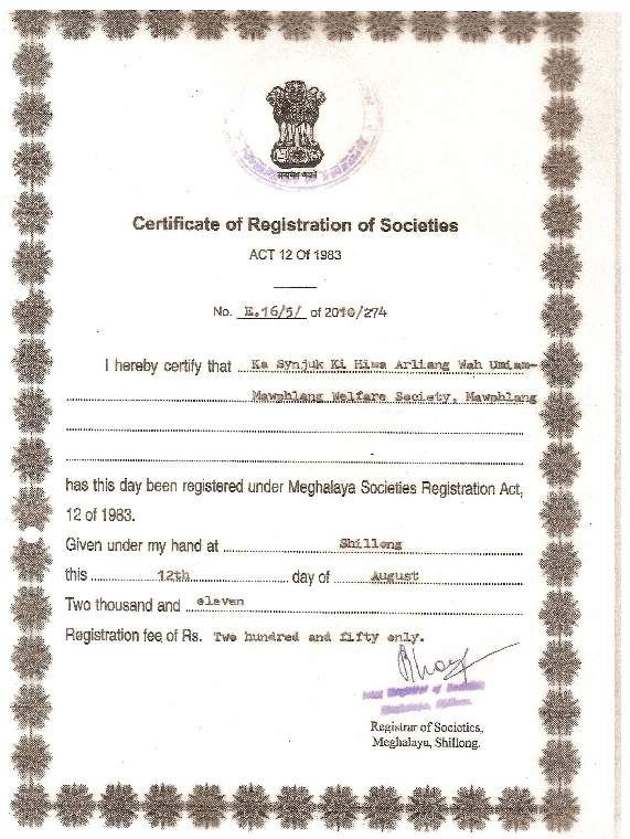
Table of Contents
 EXECUTIVE SUMMARY ............................................................................................................................ 2
 Part A: Aims and objectives ............................................................................................................... 5
   A1. Project Aims .................................................................................................................................. 5
 Part B: Site Information ..................................................................................................................... 5
   B1. Project location and boundaries ................................................................................................. 5
   B2. Description of the project area .................................................................................................... 8
   B3. Recent changes in land use and environment conditions ...................................................... 11
   B4. Drivers of degradation ............................................................................................................... 11
 Part C: Community and Livelihoods Information ............................................................................ 13
   C1. Participating Communities ........................................................................................................ 13
   C2. Description of the Socio-economic Context .............................................................................. 13
   C3. Description of Land Tenure & Ownership of Carbon Rights .................................................... 14
 Part D: Project Interventions & Activities ........................................................................................ 16
   D1. Summary of Project Interventions ............................................................................................. 16
   D2. Summary of Project Activities per Intervention ........................................................................ 19
   D3. Effects of Activities on Environment & Biodiversity.................................................................. 19
 Part E: Community participation ..................................................................................................... 21
   E1. Participatory project design ....................................................................................................... 21
   E2. Community-led implementation ................................................................................................ 23
   E3. Community-level project governance ........................................................................................ 25
 Part F: Ecosystem Services & Other Project Benefits..................................................................... 27
   F1. Carbon benefits .......................................................................................................................... 27
   F2. Livelihoods benefits ................................................................................................................... 27
   F3. Ecosystem & biodiversity benefits ............................................................................................ 28
   F4. Additionality and Environmental Integrity ................................................................................. 28
 Part G: Technical Specifications ...................................................................................................... 30
 Part H: Risk Management................................................................................................................ 30
   H1. Identification of risk areas ......................................................................................................... 30
   H2. Risk buffer .................................................................................................................................. 30
 Part I:   Project Coordination & Management .................................................................................. 31
   I1. Project Organisational Structure ............................................................................................... 31
   I2. Relationships to national organisations ................................................................................... 33
   I3. Legal compliance ....................................................................................................................... 33
   I4. Project management .................................................................................................................. 34
   I5. Project financial management .................................................................................................. 36
   I6. Marketing.................................................................................................................................... 39
   I7. Technical Support ...................................................................................................................... 39
 Part J:   Benefit sharing..................................................................................................................... 40
   J1. Memoranda of Understanding (MOU) Governing PES ............................................................. 40
   J2. Payments & Benefit Sharing...................................................................................................... 40
 Part K: Monitoring ............................................................................................................................ 42
   K1. Ecosystem services benefits ..................................................................................................... 42
   K2. Socio-economic Monitoring ....................................................................................................... 46
   K3. Environmental and biodiversity impacts ................................................................................... 48
   K4. Other monitoring ........................................................................................................................ 50
   K5. Backing up monitoring data and all other Federation records................................................ 51
 Annex 1: List of key people involved.................................................................................................... 52
 Annex 2: Producer/group agreement template .................................................................................. 53
 Annex 3: Example forest management plans (plan vivos) .................................................................. 54
 Annex 4: Permits and legal documentation ........................................................................................ 57

                                                                         4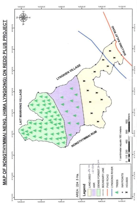
Part A: Aims and objectives
  A1. Project Aims
The project has five major aims and objectives:
   1)   To build community capacity to implement resource planning systems and mitigation
        activities in order to reverse deforestation and degradation trends impacting 9,270 ha of
        dense forests (under REDD+).
   2)   To assist communities to implement a variety of forest monitoring, protection, and
        restoration activities that facilitate the regeneration of 5,947 ha of degraded forests lands
        (under ANR).
   3)   To implement soil and water conservation measures to check soil erosion and to improve
        the hydrological function of the Umiam River sub-watershed through PES or carbon sales.
   4)   To enhance the economic conditions of participating households targeting the lowest-
        income forest dependent families. Support sustainable enterprise development among
        local communities through micro finance and sustainable farming and forestry systems
        through PES or carbon sales.
   5) To improve environmental services including the protection of endangered flora and fauna
        species found in the area through PES or carbon sales.

Part B: Site Information
  B1. Project location and boundaries
The project is located in the Sub-Watershed of Umiam River within the East Khasi Hills District of
Meghalaya, India. The area of the project is approximately 27,139 hectares comprised of 9,270
hectares of dense forests and 5,947 hectares of open forests (in 2010). The project has can be
categorized as a Single Boundary Project for Forest Restoration and Conservation. The project
boundary is defined by the traditional territories of the ten Khasi governments (hima) that are
participating in the project (see Figure 1). The area is largely consistent with the hydrological
boundaries of the Umiam River sub-watershed and is located in the East Khasi Hills District (see
Figure 2).

Project mitigation activities focus on dense forests and degraded open forests that are owned by
the community or under clan or private management. Some of the community forests exist in large,
contiguous areas of up to several thousand hectares, while other forest fragments are only several
hectares in size. Where possible, the project seeks to link forest fragments to enhance hydrological
and biodiversity services by created an unbroken wildlife corridor, especially on major and minor
riparian arteries of the Umiam River.

                                                  5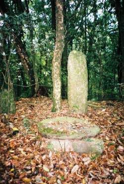
Figure 1: Khasi Hills REDD+ Project Boundaries

                                                 6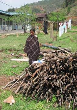
Figure 2: Umiam Sub-watershed

                                7
B2. Description of the project area
  B2.1. Geophysical description

The project area is situated in the Central Plateau Upland region of the State of Meghalaya in
Northeast India. The altitude of this plateau varies from 150 m to 1,961 m above the mean sea
level and is characterized by a great diversity in relief. The plateau is highly dissected, with steep
regular slopes to the south, which borders Bangladesh. The Central Plateau region within the
project area consist of rolling uplands intersected by rivers and dotted with rounded hills of soft
rock. The main river running through the project area is the River Umiam, which is one of the major
rivers of the State and an important source of water for the state capital city of Shillong.

    •   Sub-tropical Pine Forests: The Khasi Pine forests found in the project area are not a climax
        forest type for this area, but rather represent a successional community that colonizes
        degraded forests. They are particularly dominant in drier, more degraded sites. This is
        evident from a comparative study of the composition of old growth mixed evergreen forests
        that characterize the Khasi sacred groves and adjacent Khasi pine forests. These pine
        forests are often interspersed with broad leaved trees in valleys and shaded depressions.
        During the rainy season, there is profuse herbaceous undergrowth. Much of this growth is
        seasonal and lies dormant during winter giving a barren look to the ground vegetation.
        Moderately shaded areas and slopes support grass-legume association, which is subjected
        to grazing with terrestrial ferns forming gregarious patches all over the area.
    •   Mixed Evergreen Cloud Forests: A remarkable feature of the project area is the presence
        of remnants of a number of primary mixed evergreen forests known as sacred groves, of
        which the Mawphlang Sacred Forest is most prominent and well-preserved. These relic
        forests have evolved through centuries of protection. Such groves are rich in floral growth
        and biodiversity. Due to extremely high rainfall these mixed evergreen forests, dominated
        by oaks and chestnuts, are unique in the state. The forests are especially rich in
        endangered epiphytes and amphibians.
    •   Grassland and Savannas: The most common vegetation types of the project area are rolling
        grasslands covering large areas. Such grasslands have developed as a result of removal of
        their natural forest cover. A few scattered trees can also be seen within such grasslands.

The climate of the Khasi Hills is influenced by its topography. The central plateau region of the state
is impacted by cyclonic air movement that brings large quantities of precipitation across
Bangladesh, which is discharged in local watersheds. The climate is characterized by four seasons:
    •   A dry spring season from March to April,
    •   A hot rainy summer season (Monsoons) from May to September
    •   A mild autumn season from October to mid November
    •   A cold winter season from mid-November to February.
                                             8
The mean maximum temperature of the region ranges between 15°C in winter to 25°C and the
mean minimum temperature ranges between 5°C to 18°C. The relative humidity varies from 25%
during winter and 88% during summer season. The summer Maximum temperature is 28°C and
the minimum 12°C. Winter maximum temperature is 20°C and the minimum is 3°C. The region
is characterized by very heavy rainfall. Mawsynram, located just south of the project area, records
the world’s highest rainfall of 1,372 cm. The east-west alignment of the hill ranges of the central
plateau region exerts rain shadow effect and the rainfall towards the north is relatively lower.

  B2.2. Presence of endangered species and habitats

The geographical location of Meghalaya, in which the project is located, favoured immigration and
introduction of various animal and plants species from neighbouring countries such as China,
Myanmar and Bangladesh. As a consequence, the project areas possess a diverse mosaic of plant
and animal species, many of which are either endemic or very rare. The region is classified as a
global biodiversity hot spot under the Eastern Himalayan Endemic Bird Area. The region is also a
hot spot of amphibian biodiversity. A recent review of literature carried out by Meghalaya
Biodiversity Board reveals that a total of 436 Rare, Endangered and Threatened plant species have
been recorded from Meghalaya representing 13% of the state’s flora. Gastrochilus calceolaris,
Gymnocladus assamicus, Illichium griffithii, Pterocybium tinctorium, Saurauia punduana, Taxus
baccata and Vatica lanceafolia are few of the critically endangered plant species of Meghalaya.
Meghalaya is endowed with a rich and luxuriant orchid flora of nearly 352 species belonging to 98
genera and representing 27.08% of the country’s orchid flora. More than 110 mammal species are
known from the Meghalaya Subtropical Forests [IM0126], but none are endemic to this ecoregion.
Some of the species of conservation importance represented here include the tiger (Panthera
tigris), clouded leopard (Pardofelis nebulosa), Asian elephant (Elephas maximus), wild dog (Cuon
alpinus), Malayan sun bear (Ursus malayanus), sloth bear (Melursus ursinus), smooth-coated otter
(Lutrogale perspicillata), large Indian civet (Viverra zibetha), Chinese pangolin (Manis
pentadactyla), Indian pangolin (Manis crassicaudata), Assamese macaque (Macaca assamensis),
bear macaque (Macaca arctoides), capped leaf monkey (Semnopithecus pileatus), and hoolock
gibbon (Hylobates hoolock). The tiger, clouded leopard, Asian elephant, Assamese macaque, bear
macaque, capped leaf monkey, wild dog, sloth bear, and smooth-coated otter are threatened
species (IUCN 2000).

Many of these endangered species exist within the traditional Khasi sacred forests located in the
project area. This temperate type of primordial forests has evolved through hundreds of years of
protection. Many endangered species, which includes orchids, rhododendrons, ferns and other
flora and fauna, are still found in these forests. The rich biodiversity of this forest has attracted the
attention of biologists and research scholars from India and many other countries. While most of

                                                   9
the forests of the region have become fragmented, with little or no connectivity, a number of the
sacred groves remain linked with a broad band of pristine forests lying along both banks of Umiam
River. This stretch of forest is the last wild life refugia in the region.
The presence of areas with rich biodiversity, and harbouring rare endangered species of flora and
fauna, places no constraint on the project design and implementation as a major objective of the
project is to protect, conserve and extend the forest cover. Project implementation helps to
conserve and extend wildlife habitat and preserve the rich bio-diversity of the area. Prominent
among the rare and critically endangered and endemic flora and fauna found in the area, include
the following:
Table B2: Presence of Fauna and Flora in the Project Area
Fauna Flora
• Mammals: Pangolin, Chinese Ferret • The flora of Meghalaya is some of the
Badger, Leopard cat, Indian Porcupine, richest in India. Among the over 400
Flying Squirrel, Flying Fox, Binturong and primitive angiosperms, orchids & fern, the
Seraw, Slow Loris following species found in the project
area are critically endangered.
• Birds: Forest Wagtail, Bush Quail, Khaleej • Red Vanda, Blue Vanda, Ladies slipper
pheasant, Red fowl, Red-Yellow legged orchids and the Pitcher plant.
Falcon, Hill Partridge.
• Reptiles: Blind snake, Khasi Keel back
snake, Python.
• Amphibians: Odorana mawphangensis,
Sylvi ranadanicli, S. leploglossa, Pterora
nakhare, Philautus shillongensis, Rana
leptoglossa, Euphlyctis hexadactylus,
Bufoides meghalayanus(Khasi Hill Rock
Toad)
B2.3. Other critical factors affecting project management
A village-based survey carried out in 2010 indicated that villages with limited motorable road
access had higher rates of poverty among community families.
10B3. Recent changes in land use and environment conditions
The project area represents a landscape dominated by five primary land covers including: dense
forests with more than 40% canopy closure, open forests with 10 to 40% canopy closure, barren
or fallow lands, agricultural lands, and settlements. Forest cover has been decreasing for over a
century as populations have expanded and demands for timber, forest conversion for agricultural
land and settlements. Access to minerals through mining has driven forest felling and clearing. In
addition, natural forest regeneration in this high rainfall has been suppressed due to pressures
from fuel-wood collection, grazing and dry season forest fires. These forces have driven a pattern
of forest biomass loss that has resulted in a steady decline in forest cover and forest condition and
health.
As Table B3 indicates, dense forest has been converted into open forest and barren lands over the
past 20 years (1990 to 2010). The practice of extensive and shifting agriculture (jhum) has
declined in the project area as farmers have focused their agriculture on more fertile soils located
in valley bottoms and on lower slopes (bun farming), however some forest clearing remains on
steeper slopes. The practice of charcoal production has also impacted forests in some project
areas, as has forest clearing for commercial broom grass production.
Table B3: Land Use Change in the Project Area: 2006 & 2010
LAND USE 2006 (Ha) 2010 (Ha)
Dense forest 10,446 9,270
Open forest 5,908 5,947
Barren or fallow 5,794 6,330
Agriculture 3,179 4,777
Other (shadow*/water/no data) 1,812 814
Total Area 27,139 27,139
* visible when conducting analysis using GIS imaging
B4. Drivers of degradation
The key drivers of deforestation and forest degradation in the project area are:
• Population Growth: Meghalaya’s population increased by 30.65% between 2001 and
2011, which was 50% faster compared to India as a whole. Many rural families continue to
have 6 to 8 children, making investments in education and health care difficult. Out
migration is not an attractive option for many Khasis as they are a highly cohesive culture.
• Forest fires: Fires occur during dry months when the forest floor is covered with a thick layer
of dry leaves and needles. Fires are often set by discarded cigarettes, children playing with
matches and escaping fires from agricultural burning. An earlier pilot project developed by
Community Forestry International (CFI) demonstrated that community awareness-raising
11with community imposed prohibitions on smoking and carrying matches into the forest
have significantly reduced the incidence of fire. Building fire-lines and hiring village
firewatchers also contributed to reductions in ground fires. In addition, the establishment
of fines for those who cause fires also creates an incentive to be careful. Incidence of fire
will be monitored by the LWC as burn areas are highly visible. Rewards to communities that
prevent fire may be given at the end of the fire season. Training in fire safety and control is
also important as communities may use fire to establish fire-lines (sanding) as well as for
agricultural clearing.
• Unsustainable fuel wood collection: Over 99% of the rural community uses firewood as their
sole source of fuel. Being situated in a relatively cold region, firewood consumption per
household in the area is high, averaging 10 to 20 kg per household per day. Firewood is
collected from nearby forests. If dead trees are not available, people resort to felling live
trees and saplings. While some villages have regulations guiding fuel wood collection,
many do not or these systems have broken down. The establishment of an NRM (plan vivo)
planning process will help communities re-establish sustainable firewood production
systems.
• Charcoal making: There is a significant demand for charcoal in Meghalaya. Charcoal is used
by iron-ore smelting industries and it is also used for heating homes and offices in urban
centers such as the city of Shillong. Charcoal making and its purchase by industries is illegal
in Meghalaya. Charcoal making is concentrated in a few villages with limited alternative
income generating opportunities.
• Stone Quarrying: There is a large demand for stone, sand and gravel for construction in
Shillong city. Many stone quarries exist in the project area. Quarries are usually on steep
slopes and they lead to erosion and landslides. Hima governments will be asked to place a
moratorium on leasing land for quarries and not extend existing leases wherever possible.
• Uncontrolled Grazing: The rural communities allow cattle, goats and sheep to graze in
nearby forest areas. Grazing causes forest degradation as young seedlings and saplings
are grazed or trampled. Grazing animals are reported to have little economic value with
communities often eager to switch to stall-feeding and higher quality livestock.
• Agricultural Expansion: Communities or clans own most of the forests in the project area.
However, when community and clan forests are privatized they are often permanently
cleared for agriculture. Forest clearance is also practiced for extensive and shifting
agriculture (jhum) on steep slopes. Agricultural expansion is taking place in several Hima
in the southern part of the project area where businessmen are providing loans to families
to clear forests and plant broom grass for markets in other parts of India. Slowing and
halting this process will require consultations with farmers involved in this activity to
discuss alternative agricultural and other economic activities which could be supported
both through the project as well as under Government of India schemes and projects.
12Part C: Community and Livelihoods Information
C1. Participating Communities
The project focuses on the involvement of the Khasi people, an indigenous tribe in the state of
Meghalaya, which is in the northeast of India, bordering Assam (India) and Bangladesh. The
majority of the population in the Khasi Hills speaks Khasi, their native language. About 85% of the
Khasi are Christians while a substantial minority practice the indigenous Khasi religion, which has
influenced the clan system of Khasi society: Khasi land is divided into governments (himas) which
are headed by the chiefs of the most influential clans. The system of descent and inheritance is
matrilineal, meaning that women continue family lineages and property is passed on to the
youngest daughter.
In the project area, there are 4,357 households representing a population of 25,411 with an
average household size of 5.8 members. The villages are almost exclusively Khasi, with 62 villages
administered through their traditional village councils (Dorbar) under the overall supervision of 10
indigenous governments (hima). These indigenous governments are represented by the Khasi Hills
Autonomous District Council (KHADC).
Average village size is 73 households, though project communities vary in size from 12 households
to 262 households. The target households and communities reside around the private, clan and
community forests in the project area. Community forests are managed and controlled by the Hima
Dorbar (council) for the benefit communities in the area. The project also involves forest owning
clans and households with private forest.
C2. Description of the Socio-economic Context
The main occupation of all target groups mentioned previously is agriculture. The main crops grown
are rice, maize, potatoes and vegetables. To supplement their incomes the farmers also rear
livestock such as cows, sheep, goats, pigs and poultry. The average land holding in the project area
is only 0.25 ha per household. In 2010, a baseline survey undertaken by the Bethany Society
showed that the average annual income per household (of 5 or 6 members) was just Rs. 30,000
– less than USD$ 2 per day. Some 29% of households interviewed had an annual income of
between Rs. 6,000 and Rs. 24,000. The project’s village survey indicated that in most project
communities 80 to 90% of the households were below the poverty line. Poverty and lack of
employment opportunities was one of the most frequently noted problems facing project villages.
Development priorities include creating jobs, better road access, improved water supplies, and
improved access to schools and health facilities.
The East Khasi Hills district data reflects the areas heavy dependence on agriculture and natural
13resources, yet population expansion is exceeding land and forest carrying capacity. As mentioned
above, Meghalaya’s population increased by 30.65% between 2001 and 2011, which was 50%
faster compared to India as a whole. Many rural families depend on large families to carry on with
subsistence farming and other livelihood activities. Out migration is not an attractive option for
many Khasis as they are a highly cohesive culture. As a result, remittances from Khasi working out
of the state to rural communities are limited. It appears rapid population growth over the past
century remains an underlying cause of poverty and environmental degradation in the project area.
In the project area, potatoes are the major crop with average production of 9.9 metric tonnes per
hectare. Other important crops include: rice, cabbage, peas, sweet potatoes, beans, maize and
turnips. Heavy use of fertilizers and chemical inputs are reported to be causing soil problems with
the result that yields are falling in some areas. Despite the high price of inputs, vegetable prices
may not reflect producer costs, with potatoes selling as low as Rs. 5 per kilo. Farm families are
experimenting with alternative production systems especially the cultivation of fruit trees including
peaches, plums, pears and other stone fruit. Improved animal husbandry systems such as stall fed
pig and poultry raising, and fresh water aquaculture are also popular rural enterprises.
The project communities are demonstrating a strong commitment to education with a rural literacy
rate for the district of 55%. Khasi society is quite literate and most families place a high value on
educating their children. High levels of school attendance are common among village youth,
especially girls, who often seek high school graduation or college degrees. Access to schools, roads
and markets varies among the project villages. Based on village profiles conducted by the project
team, the 62 villages can be categorized according to their size, access to services and forest
dependence.
The village profiles indicated that 56% of the 62 villages had a high forest dependency with 1 to 3
community forest blocks within 1 to 2 km of the village. Access to roads was also a factor with 11%
of the villages at least 0.5 km from the nearest road. Some remote hamlets were up to 5 km from
the road. The village survey indicates that villages with limited motorable road access had higher
rates of poverty among community families.
C3. Description of Land Tenure & Ownership of Carbon Rights
The state of Meghalaya is governed under the Sixth Schedule of the Constitution of India. This
means that customary beliefs and practices are recognized and legitimized, including those
governing the management of land, forests, minerals and other resources. The Sixth Schedule
bestows the rights of resource management to the indigenous people of the state and their
traditional institutions, coordinated by Autonomous District Council. The Khasi Hills of Meghalaya
14is comprised of small tribal administrative units known as Hima. Less than 10% of the State’s
forests are under the authority of the Government of India and the State Forest Department, and
these are largely limited to national parks and wildlife sanctuaries, while the remaining 90% is held
by communities, clans, and families.
Aside from private forests, most of the forests in the project area are under the stewardship of one
of the 10 respective Hima and are managed Hima Dorbar, an indigenous council represented by
all male adults of every constituent village. These community forests are managed for the benefit
of the entire community under including strict conservation of sacred forests, as well as multiple-
use in production forests. The community members are the actual owners of these community
forests. The Hima Dorbar does not own any land, rather they are custodians elected to manage
and control such forests. Private forests are under the control of the owners, who may be private
individuals or members of a clan.
The Project area is comprised of ten such Hima, which have formed a Federation to coordinate
management. In August 2011, the Federation registered under the Meghalaya Societies
Registration Act as “Ka Synjuk Ki Hima Arliang Wah Umiam, Mawphlang Welfare Society” of
Meghalaya. Carbon benefits arising out of the project are wholly owned by the Synjuk Federation
and are used to cover the costs of mitigation activities and management, with the balance
distributed to the 62 villages within the ten hima through annual development grants.
The land tenure for each forest owner, be they owners of clan, private or community forests, has
been established during the project design phase. Forest boundaries are well known and accepted,
and in the few cases where disputes have arisen, they have been resolved. When forest conflict
arises, they are settled by the Hima Dorbar, or referred to the Autonomous District Council. The
Khasi Hills Autonomous District Council has approved this REDD+ project as the formal
Government of India agency representing the indigenous governments. In addition, the project has
been recognized by the Meghalaya Department of Environment and Forests and collaborates
closely with the State Government’s Climate Change Center. Carbon revenues are also to be used
to meet the operational costs of the federation and the LWC, who are responsible for project
administration, coordination, and management of mitigation and livelihood activities, monitoring,
and reporting.
15Part D: Project Interventions & Activities
D1. Summary of Project Interventions
The Khasi Hills project seeks to prevent the conversion and degradation of ecosystems through
REDD+, comprised of forest conservation and an ANR component. The project aims to slow, halt,
and reverse the loss and the degradation of forests in Meghalaya and is the first REDD+ project in
India. Restoration of degraded forests are achieved by supporting communities in land
management and forest regeneration activities that yield livelihood benefits. The project supports
the development of community natural resource management (NRM) plans for the management
of forests and micro-watersheds. Where possible, the project will link forest fragments to enhance
hydrological and biodiversity services, especially on major and minor riparian arteries of the Umiam
River.
Project Interventions can be summarised in the following way:
• Program Management and Institution Building: A key component in the REDD+ project strategy
is to build the capacity of indigenous governments to protect and restore community forests.
While indigenous governments and communities possess legal ownership of local forests,
increasing population and economic pressures combined with an erosion of local controls has
resulted in rapid depletion of forest resources. By strengthening local institutions and
management capacities forest stewardship can improve. This component includes four key
tasks:
1) Uniting the ten indigenous governments (hima) within a resource management Federation
to oversee the planning and coordinate strategy and financial support.
2) Establishing Local Working Committees (LWC) that can support the 62 participating villages
to formulate natural resource management plans. The LWC operating and responsive to
their respective hima and the Federation.
3) Supporting the participating villages to prepare their natural resource management plan
and initiate mitigation and livelihood activities.
4) Engaging government and civil society partners to collaborate in implementing the REDD+
project, drawing on their technical and financial resources.
• REDD+ Mitigation Activities: Reducing emissions from deforestation and forest degradation is
a core component of any REDD+ project. The project seeks to achieve a range of hydrological
and biodiversity goals, including storing and sequestering carbon. This is achieved through five
activities:
o Advance Closure: This initial activity involves mobilizing communities to restrict access and
use of degraded forests, which possess good regenerative potential reflected in the
presence of saplings and seedlings, rootstock for coppicing species, and favourable soil
16and moisture conditions. These sites would be closed to grazing and fuel wood collection
for an initial period of 5 years to allow them to regenerate. The community would also be
responsible for preventing forest fires in the area. After several years, the area may be
treated with Assisted Natural Regeneration activities.
o Assisted Natural Regeneration: The second activity involves selecting open forest sites with
high potential reflected in the presence of viable root stock and mother trees for assisted
natural regeneration (ANR) treatment. This activity requires 10 person days per hectare for
thinning, multiple coppice shoot cutting, and weeding undesirable species. ANR treatment
just costs approximately 10 to 20% of plantation costs and results in accelerated forest
regeneration with natural species and high survival rates. The project is currently
implementing ANR treatment on 1,500 hectares of degraded open forests identified by
communities with another 1,500 hectares targeted for treatment over the next five years.
o Controlling Forest Fires: The third activity involves the controlling of ground and canopy
forest fires. Dry season fires delay natural regeneration in degraded forests and threaten
dense forest areas, while emitting substantial carbon emissions. CFI’s earlier pilot projects
indicate that through the establishment of fires lines (a traditional practice in Khasi
society), the creation of awareness regarding the need to control fires quickly and
effectively, and the provision of fire watchers during the dry season, both the extent and
frequency of forest fires can be dramatically reduced.
o Sustainable Fuelwood Production: The fourth task requires developing sustainable systems
to produce fuel wood. Khasi households consume between 15kg and 20kg of fuel wood
daily. Hacking and collection of firewood both reduces forest biomass and health. The
establishment of sustainable fuel wood harvesting systems in natural forests can result in
improved forest condition in the project area. Harvesting plans and rules that identify the
time and place for fuelwood collection, as well as permitted volume allowed for extraction
are established by the village councils to regulate forest use.
o Reduce Fuelwood Consumption: The fifth activity focuses on reducing fuel wood
consumption through the installation of fuel-efficient stoves. Traditional stove technologies
are inefficient and create health problems by emitting smoke into the household. Fuel-
efficient stoves can reduce fuel wood consumption by 30 to 50% and with new smoke
stacks can direct harmful smoke out of the house. The project aims to train SHGs and youth
in the manufacturing and installation of smokeless, fuel-efficient stoves and the acquisition
and distribution of liquid petroleum gas (LPG) cook tops and seeks to install these in at
least 80% of project households over a ten-year period.
• Livelihood Activities
Poverty is a major problem in the project area where 80% or more of the households in the 62
villages live below the poverty line of USD$2 per day. To be successful this REDD+ project
17addresses livelihood needs. This includes the implementation of five activities:
o Community Benefit Sharing Program: The project shares revenues from carbon offset sales
through the provision of annual Community Development Grants to all participating
villages. The grants vary from Rs. 15,000 to Rs. 25,000 ($225 to $360) depending on net
revenues available for funding small development projects identified by each village.
Projects include drinking water enclosures, ponds, playgrounds, and civic building projects.
o Livelihood Program - Women’s Self Help Groups: This livelihood strategy involves the
development of Self Help Groups (SHGs) and targets women. SHGs are organized and
trained in bookkeeping, micro-finance, GOI bank programs, and small enterprise
development. Aside from training, the project provides small seed grants to help in
establishing SHGs. The project also collaborates with government projects and schemes
involved in micro-finance group development as well as with local NGOs working in this
area. SHGs are involved, where possible, in other project activities including the fuel-
efficient stove project, the sustainable farming system program, and the ecotourism
strategy. Earlier pilot project experience suggested that many families wished to improve
their income from livestock and transition to more intensive stall feeding. This strategy not
only increases income from animal husbandry, but also accelerates forest restoration. The
project provides support with the construction of stall and pens. It assists communities to
access government veterinary services and connect with markets. The project provides
women’s micro-finance groups with piglets and poultry and is developing a pig-breeding
program for the project area.
• Livelihood Program – Farmers’ Clubs: The second strategy is the Sustainable Farming
Systems Program which targets men. This approach is designed to improve farm incomes
and reduce negative environmental impacts from the current heavy dependence on
chemical fertilizers and pesticides. Special attention is given to assisting farmers to
transition from low value potato cultivation to raising fruit trees, especially stone fruits, cut
flowers, and other high value crops. The project provides farmer’s clubs with poly-houses,
a type of green house that extends the growing season through with the assistance of the
Indian Council of Agricultural Research. These institutions have the necessary
infrastructure to impart training to farmers and agriculturists to improve production. The
project sponsors such training. Scientists from these Institutions are invited to come to the
project area to demonstrate modern practices in these fields. Such training is accompanied
by construction of poly houses, training in animal husbandry techniques and the
construction of pigpens and poultry raising.
18D2. Summary of Project Activities per Intervention
Table D2 – Description of activities
Eligible for
Intervention
Project Activity Description Target group PV accred-
type
itation
Program Establish Local • LWC facilitate NRM Planning Community No
Management Working • Training and employment for community (Federation,
and Institution Committees to NRM team Hima, and
Building manage micro- Village
watersheds Councils
REDD+ Forest • Institutional strengthening, Establishing Community Yes
protection a common approach to forest protection group
and management by all participating
communities (Himas and Durbar
• Forest boundary dispute resolution
• Forest Management Planning
• Controlling Forest Fires
• Sustainable fuelwood production and
consumption
Afforestation Assisted natural • Restriction of forest areas for grazing and Community Yes
and regeneration fuelwood collection group
Reforestation • Community weeding, thinning, MSC
performed on regenerating open forests.
• Enrichment planting
• Protection of natural regeneration of
native species
• Homebased Nurseries
Reduced Energy • Distribution of Fuel Efficient Stoves and Households
Fuelwood Transition LPG Cooktops No
Consumption • Creation of charcoal Briquette Making
enterprises
Livelihood Income • Piggery and Poultry Projects Self-help No
Activities Generation for • Ecotourism Groups
Low Income • Home-based Nursery Management
Households
Income • Sustainable Farming Systems Farmers’ Clubs No
Generation for • Horticulture Projects
Low Income
Households
D3. Effects of Activities on Environment & Biodiversity
D3.1. Project Impacts on Biodiversity
Project activities will have a far-reaching impact on biodiversity in the project area. In addition to
delivering climate benefits, forest protection will prevent the loss of biodiversity. Enrichment
planting will be carried out using only native and naturalised tree species. Moreover, the REDD+
project is expected to enhance, or at the very least maintain, levels of biodiversity by expanding
and maintaining habitats.
Reducing the impact of key drivers of deforestation and degradation, especially forest fire and fuel
19wood collection, should allow for rapid re-growth of pine and mixed-evergreen forests. By the end
of the project, field inventories and satellite imagery should show indications of young secondary
forests on 3,000 hectares of area that is currently badly degraded. These young secondary forests
should be between 5 to 10 meters in height. The project also seeks to link forest fragments
connecting old growth patches in sacred forests and community forests, with newly regenerating
forest areas.
Fire management plans including creation and maintenance of fire lines, employment of seasonal
firewatchers to reduce forest loss from fire and improve and extend wildlife habitats. Steps are also
planned to create wildlife refugia by creation of Wildlife Corridors. Rules on hunting and awareness
raising programs should also increase the recovery of endangered animal and bird populations.
The project also seeks to give special attention to endemic species of orchids and amphibians by
creating special refugia and conservation and education activities.
D3.2. Environmental impacts on soil and water
Project activities are unlikely to lead to any negative environmental impacts. Reducing
deforestation and forest degradation will help to prevent soil erosion and contribute to better water
quality within the project boundaries. The project seeks to improve the hydrology of the Umiam
Watershed by protecting and restoring watershed forests, implementing soil and water
conservation measures, and improving the management of riparian areas.
This riparian artery is too steep for settlements or agriculture and falls within the core project area,
so conservation imposes minimal economic loss to local communities. Assisted Natural
Regeneration (ANR) is the primary approached to the restoration of degraded forests due to its low
cost and biodiversity benefits. The project intends to implement ANR on 500 hectares each year,
with target areas identified in the 18 micro-watershed plans. This aims to cover most of the 5,000+
hectares of degraded open forest in the project area over the next decade. The level of intensity
of effort (i.e. weeding, thinning, enrichment planting) in the target areas will depend on funding
from the national rural employment guarantee act -NREGA), as well as carbon revenues. At a
minimum, ANR will include protection from forest fires, grazing, and fuel wood collection.
The project also seeks to improve the hydrology of the Umiam Watershed by protecting and
restoring watershed forests, implementing soil and water conservation measures, and improving
the management of stream and rivers embankments (see Table 4). The project is working to
establish indicators regarding volume and duration of spring and stream flows to assess how
changes in forest cover are impacting water availability.
20Part E: Community participation
E1. Participatory project design
E1.1. Planning Process
Participation in the project grew out of an earlier PES pilot project in Hima Mawphlang. The original
pilot project was initiated at the request of the Hima leadership and community. Subsequently,
nine additional indigenous kingdoms in the project area made a request to CFI to join the emerging
REDD+ project initiative. After CFI agreed to support the expanded project, the ten hima formed a
Federation to coordinate and manage the activities. As there are 62 villages under the supervision
of the ten Hima, each village was consulted regarding their willingness to participate in the project.
All 62 communities in the project area have participated in a series of awareness raising activities
that included a description of the project. After their own internal discussions they had the option
to participate in the project. In 2012-2013, all 62 villages agreed to participate and agreed to sign
a community resolution on conservation and protection of forests. Private and Clan forest owners
that wish to join the project may also agree to the terms of the project, though no special payments
are provided to them other than those shared by other members of their local community.
E1.2. Governance of Community Groups
Villages prepare their own Natural Resource Management (NRM) plans, which are organised into
clusters. These plans include community recommendations on ways and means to enhance
incomes and the standard of living of the local community. These clusters work with Lower Working
Committees (LWCs) where NRM plans are discussed and then submitted to local Community
Facilitators (CFs), who then incorporate all feasible proposals of the community NRM plans into a
strategy for their respective Hima and present them to the Federation. The Federation then reviews
NRM plans together with the Forestry Team working with the Synjuk (Figure 3). Each of the 62
participating villages have designed and implemented local NRM plans and have signed an
agreement with the Synjuk to participate in the REDD+ project (see Annex 2).
21Figure 3: Community-based governance
Synjuk Federation
(Federation of Himas)
Hima
Community
Facilitator (CF)
LWC LWC
Village Village Village Village
Levels of Community Governance:
• Village-Level: The project has the following key staff at the field level
o Youth Volunteers: One per village who help to undertake forest monitoring and socio-
economic activities.
o Self-Help Groups: Ten to fifteen members, mainly women, who propose and carry out
activities that contribute to the livelihoods of the people in individual villages, such as
piggery, poultry or running a store.
o Farmers’ Clubs: About twenty farmers, mostly male, join together to carry out activities,
such as carpentry, poultry and piggery.
o Project Participants: Villages prepare NRM plans which contain forest conservation
activities, as well as livelihood projects to improve living conditions at village-level.
• Lower Working Committees (LWCs): Participating communities are generally clustered into
groups of 2-5 villages, to form Village Working Units (VWU) in consultation with the
concerned Hima. Villages within such clusters are close proximity to one another. One male
and one female from each village, as well as the village headmen, constitute a Local
Working Committee (LWC). The Chief of each Hima (i.e. the Syiem, Lyngdoh, etc.), acts as
the Chairman of all LWCs falling within his area of jurisdiction
• Community Facilitators (CF): CFs are appointed in each Hima, by the Hima Dorbar. The CF
22is chosen by consensus and must be educated, influential and a respected member of the
community. His job includes awareness campaigns within the Hima to sensitize people on
the need to conserve the forests and natural resources and to manage them sustainably
as well as to train Local Working Community members and Extension Workers on all
aspects of project works, including book keeping and maintenance of accounts and all
aspects of data collection including livelihood & socio-economic indicators.
• Federation of Himas (Synjuk Federation): A Federation comprising of all ten Hima Dorbar
has been formed to represent all the forest owners of the project area (see Annex 4). The
Federation is registered with the government as a charitable society. The long-term aims
and objectives of this society include the conservation of the forest, its fauna and flora and
to initiate steps to improve the quality of life of the community. Such a Federation ensures
the adoption of a collective approach to all the scheduled activities as well as an equitable
sharing of the benefits. The Federation gives the indigenous traditional Institutions a much
stronger voice in all matters relating to forest conservation and relies on knowledge sharing
and transfer of skills to ensure a uniform approach to natural resource management. The
Federation is in a powerful position to bargain for allocation of funds from the government
for the management and control of community forests. The exact constitution, by-laws, and
objectives of the Federation are decided upon by the concerned Hima Dorbars themselves.
E1.3. Barriers to Participation
The project aims to remove barriers to participation by involving women and men equally at various
stages in the project operations. In Lower Working Committees there must be equal representation
by men and women. One man and one woman must represent a village as members in the LWC.
Moreover, women are especially involved in Self-Help Groups (SHGs), which are common
institutions across India to ensure self-financing of local development objectives. Traditionally, the
ten to fifteen members of SHGs are mainly made up of women, although men are permitted to join
as members. As of 2016, the project aims to employ female Community Facilitators (CFs) who will
specifically represent women’s interests in the project.
E2. Community-led implementation
Apart from preparing Natural Resource Management (NRM) plans together with village headmen.
These plans are then discussed with Lower Working Committees (LWCs) which represent clusters
of 2-5 villages. Once NRM plans are discussed at LWC level, they are submitted to Community
Facilitators (CFs) who consolidate plans for their respective Hima and submit them to the Synjuk
Federation.
Once the Synjuk Federation receives NRM plans, different teams employed by the Synjuk
23You can also read