Environmental Assessment and Finding of No Significant Impact - April 2017 - Miami-Dade County, Florida
←
→
Page content transcription
If your browser does not render page correctly, please read the page content below
April 2017

                 Environmental Assessment and
                Finding of No Significant Impact

              MODIFIED WATER DELIVERIES TO
EVERGLADES NATIONAL PARK PROJECT: REMOVAL
 OF UNCONSTRUCTED CONVEYANCE AND SEEPAGE
                        CONTROL FEATURES

        Miami-Dade County, Florida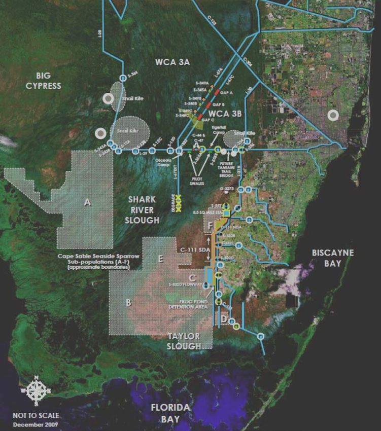
This page intentionally left blank
FINDING OF NO SIGNIFICANT IMPACT
MODIFIED WATER DELIVERIES TO EVERGLADES NATIONAL PARK PROJECT:
REMOVAL OF UNCONSTRUCTED CONVEYANCE AND SEEPAGE CONTROL
FEATURES
MIAMI-DADE COUNTY, FLORIDA
The U.S. Army Corps of Engineers, Jacksonville District (Corps), has conducted an environmental
assessment in accordance with the National Environmental Policy Act of 1969, as amended. The
Corps assessed the effects of the following actions in the Modified Water Deliveries to Everglades
National Park (MWD) Project: Removal of Unconstructed Conveyance and Seepage Control
Features Environmental Assessment (EA), dated February 2017, and the Corps technical analysis
dated September 2015 (Appendix A) for the MWD Project in Miami-Dade County, Florida. The
proposed action consists of the following:
Removal of authorized conveyance and seepage control features (CSCF) originally
included in the MWD Project CSCF components that have not been constructed.
Specifically, the components to be removed from the authorized project and associated
Project Cooperation Agreement (PCA) include: (1) gated culvert structures S-345A, B, and
C through the L-67A; (2) gated concrete headwall structures S-349A, B, and C in the L-
67A Borrow Canal; and (3) degradation of the remaining 5.5 miles of the L-67 Extension.
Amending the PCA between the Corps and the non-federal sponsor, the South Florida
Water Management District (SFWMD), to revise the term "project" to eliminate the
unconstructed CSCF components and incorporate the 2012 design refinement for the 8.5
SMA. The current PCA, which identifies cost share and construction, operation, and
maintenance responsibilities, defines the term "project" by referring to the 1992 MWD
General Design Memorandum and Environmental Impact Statement (GDM/EIS), 2000 8.5
Square Mile Area (SMA) General Reevaluation Report and Environmental Impact
Statement (GRR/EIS), and 2008 Tamiami Trail Modifications (TTM) Limited
Reevaluation Report and Environmental Assessment (LRR/EA).
Completion of a series of operational tests (MWD Increment 1, MWD Increment 1.1/1.2,
MWD Increment 2, and development of a Combined Operational Plan (COP) for the
constructed features of the MWD Project and Canal 111 South Dade Project features. At
this time, COP is anticipated to be implemented by 2019. It must be noted, however, that
operational testing under the MWD Project increments may reveal the need for additional
construction to address adverse effects associated with increased flow into Everglades
National Park (ENP) associated with the MWD Project.
Development of an Operations, Maintenance, Repair, Rehabilitation, and Replacement
(OMRR&R) Manual before the features can be transferred to SFWMD for operation. The
OMRR&R Manual will be developed based on the results of the incremental testing and
the comprehensive water control plan update (i.e. COP).
In addition to the No Action Alternative, two alternatives were evaluated, including the proposed
action. While the proposed action will not achieve the benefits to Water Conservation Area 3B as
originally envisioned in the 1992 MWD GDM/EIS, the Recommended Plan is consistent with
MWD Project design refinements documented within the 2000 8.5 SMA GRR/EIS, the 2008 TTM
I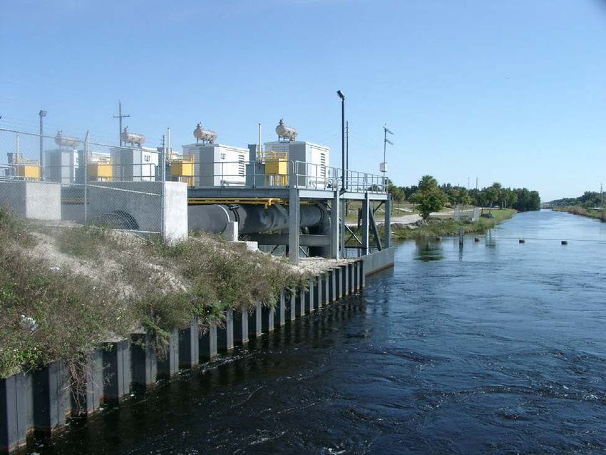
LRR/EA, and the 2012 8.5 SMA EA. In addition, as outlined in Appendix A, and in coordination
with the Department of the Interior and SFWMD, the Corps 2015 technical analysis determined
that the previously constructed MWD Project features, the MWD Project features currently under
construction, C-358 and S-357N, along with the acquisition of remaining real estate interests and
completion of a project water control plan (i.e. COP), will achieve the statutory charge to improve
water deliveries into ENP and, to the extent practicable, restore the natural hydrological conditions
within ENP.

Given that the authority under which the MWD Project was developed was focused on delivery of
water to ENP and improvement of the hydrology, to the extent practicable within ENP, the design
changes and additional costs to make the necessary changes to the MWD Project to provide the
benefits envisioned in the 1992 MWD GDM/EIS outside ENP would be difficult to justify under
this authority. Although located within ENP, the 2008 TTM LRR/EA concluded that degradation
of the remaining L-67 Extension may cause stages to exceed the MWD Project L-29 Borrow Canal
maximum operating limit and compromise the condition of the Tamiami Trail roadway. Further
improvements to water delivery volumes into ENP by up to 92%, compared to pre-MWD
conditions described in the LRR, and improved hydrologic conditions within ENP can be expected
upon completion of COP. Applicable real estate acquisitions must be completed to support the
MWD increments operational tests needed to inform COP.

I have reviewed the Environmental Assessment (EA) for the Proposed Action. This Finding
incorporates by reference all discussions and conclusions contained in the EA enclosed hereto.
Based on the information analyzed in the EA, which reflects pertinent information obtained from
agencies having jurisdiction by law and/or special expertise, I conclude that the Proposed Action
will not significantly affect the quality of the human environment and does not require an
Environmental Impact Statement. Reasons for this conclusion are in summary:

   a. The Proposed Action is in compliance with the Endangered Species Act and the Fish and
      Wildlife Coordination Act. The Corps agrees to maintain open and cooperative
      communication with the U.S. Fish and Wildlife Service, National Marine Fisheries Service,
      and the Florida Fish and Wildlife Conservation Commission regarding actions necessary
      to complete the MWD Project.

   b. A Federal consistency determination, in accordance with 15 CFR 930 Subpart C of the
      Coastal Zone Management Act, or a Section 404(b)(1) evaluation under the Clean Water
      Act, are not necessary to support the determination to remove specific CSCF components
      from the MWD Project and associated PCA amendment. The Corps determined that the
      Proposed Action is consistent, to the maximum extent practicable, with the enforceable
      policies of Florida’s approved Coastal Zone Management Program.

                                                 II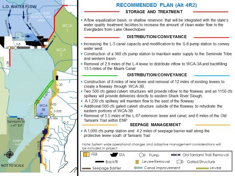
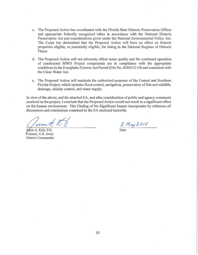
c. The Proposed Action has coordinated with the Florida State Historic Preservation Officer
       and appropriate federally recognized tribes in accordance with the National Historic
       Preservation Act and considerations given under the National Environmental Policy Act.
       The Corps has determined that the Proposed Action wi ll have no effect on historic
       properties eligible, or potentially eligible, for listing in the National Register of Historic
       Places

    d. The Proposed Action will not adversely affect water quality and the continued operation
       of constructed MWD Project components are in compliance with the appropriate
       conditions in the Everglades Forever Act Penn it (File No. 0246512-10) and consistent with
       the Clean Water Act.

    e. The Proposed Action will maintain the authorized purposes of the Central and Southern
       Florida Project, which includes fl ood control, navigation, preservation of fish and wildlife,
       drainage, salinity control, and water supply.

In view of the above, and the attached EA, and after consideration of public and agency comments
received on the project, I conclude that the Proposed Action would not result in a significant effect
on the human environment. This Finding of No Significant Impact incorporates by reference all
discussions and conclusions contained in the EA enclosed herewith.

   on A. Kirk, P.E.                                              Date
 olonel, U.S. Army
District Commander

                                                Ill
Table of Contents
ENVIRONMENTAL ASSESSMENT
ON
MODIFIED WATER DELIVERIES TO EVERGLADES NATIONAL PARK PROJECT:
REMOVAL OF UNCONSTRUCTED CONVEYANCE AND SEEPAGE CONTROL
FEATURES
MIAMI-DADE COUNTY, FLORIDA
TABLE OF CONTENTS
TABLE OF CONTENTS
ENVIRONMENTAL ASSESSMENT AND FINDING OF NO SIGNIFICANT IMPACT .......... I
1.0 PROJECT PURPOSE AND NEED ................................................................................. 1-1
1.1 PROJECT AUTHORITY ............................................................................................ 1-1
1.2 PROJECT LOCATION ............................................................................................... 1-2
1.3 PROJECT BACKGROUND ....................................................................................... 1-4
1.4 PROJECT NEED OR OPPORTUNITY .................................................................... 1-10
1.5 AGENCY GOALS AND OBJECTIVES .................................................................. 1-11
1.6 RELATED ENVIRONMENTAL DOCUMENTS .................................................... 1-11
1.7 DECISIONS TO BE MADE ..................................................................................... 1-13
1.8 SCOPING AND ISSUES .......................................................................................... 1-13
1.9 PERMITS, LICENSES, AND ENTITLEMENTS .................................................... 1-13
2.0 ALTERNATIVES............................................................................................................ 2-1
2.1 DESCRIPTION OF ALTERNATIVES ...................................................................... 2-1
2.1.1 ALTERNATIVE A: NO ACTION ALTERNATIVE ............................................. 2-1
2.1.2 ALTERNATIVE B: REMOVAL OF CSCF COMPONENTS (S-345A, B, and C; S-
349A, B, and C AND REMAINING L-67 EXTENSION CANAL AND LEVEE
REMOVAL) FROM MWD PROJECT ............................................................................... 2-1
2.1.3 ALTERNATIVE C: REDESIGN AND CONSTRUCT CSCF COMPONENTS
BASED UPON NEW TECHNICAL INFORMATION. ..................................................... 2-2
2.2 ISSUES AND BASIS FOR CHOICE.......................................................................... 2-2
2.3 ALTERNATIVES ELIMINATED FROM DETAILED EVALUATION .................. 2-3
2.4 PREFERRED ALTERNATIVE .................................................................................. 2-4
3.0 AFFECTED ENVIRONMENT ....................................................................................... 3-1
3.1 GENERAL ENVIRONMENTAL SETTING.............................................................. 3-1
3.2 CLIMATE .................................................................................................................... 3-1
3.3 GEOLOGY AND SOILS ............................................................................................ 3-1
3.4 STUDY AREA LAND USE........................................................................................ 3-2
3.5 HYDROLOGY ............................................................................................................ 3-2
3.5.1 WATER CONSERVATION AREAS 3A AND 3B ................................................ 3-2
3.5.2 NORTHEAST SHARK RIVER SLOUGH ............................................................. 3-3
3.5.3 LOWER EAST COAST AREA .............................................................................. 3-4
3.5.4 8.5 SQUARE MILE AREA ..................................................................................... 3-4
3.6 FLOOD CONTROL .................................................................................................... 3-4
3.7 VEGETATIVE COMMUNITIES ............................................................................... 3-4
3.8 FISH AND WILDLIFE RESOURCES ....................................................................... 3-6
MWD Project EA April 2017
iTable of Contents
3.9 THREATENED AND ENDANGERED SPECIES .................................................... 3-7
3.9.1 FEDERALLY PROTECTED SPECIES.................................................................. 3-7
3.9.2 STATE LISTED SPECIES ...................................................................................... 3-9
3.10 ESSENTIAL FISH HABITAT .................................................................................. 3-10
3.11 WATER QUALITY................................................................................................... 3-10
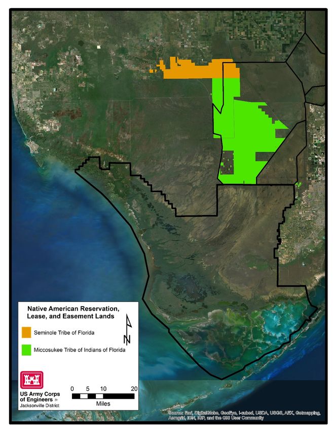
3.12 NATIVE AMERICANS ............................................................................................ 3-11
3.13 CULTURAL RESOURCES ...................................................................................... 3-12
3.14 AIR QUALITY .......................................................................................................... 3-13
3.15 HAZARDOUS, TOXIC, OR RADIOACTIVE WASTES ........................................ 3-13
3.16 NOISE ........................................................................................................................ 3-14
3.17 AESTHETICS............................................................................................................ 3-14
3.18 SOCIOECONOMICS ................................................................................................ 3-14
3.19 AGRICULTURE ....................................................................................................... 3-15
3.20 RECREATION .......................................................................................................... 3-15
4.0 ENVIRONMENTAL EFFECTS ..................................................................................... 4-1
4.1 GENERAL ENVIRONMENTAL EFFECTS.............................................................. 4-1
4.2 CLIMATE .................................................................................................................... 4-1
4.3 GEOLOGY AND SOILS ............................................................................................ 4-1
4.3.1 ALTERNATIVE A: NO ACTION ALTERNATIVE ............................................. 4-1
4.3.2 ALTERNATIVE B: REMOVAL OF CSCF COMPONENTS (S-345A, B, and C, S-
349A, B, and C AND REMAINING L-67 EXTENSION CANAL AND LEVEE
REMOVAL) FROM MWD PROJECT ............................................................................... 4-1
4.4 STUDY AREA LAND USE........................................................................................ 4-2
4.5 HYDROLOGY ............................................................................................................ 4-2
4.5.1 ALTERNATIVE A: NO ACTION ALTERNATIVE ............................................. 4-2
4.5.1 ALTERNATIVE B: REMOVAL OF CSCF COMPONENTS (S-345A, B, and C; S-
349A, B, and C AND REMAINING L-67 EXTENSION CANAL AND LEVEE
REMOVAL) FROM MWD PROJECT ............................................................................... 4-5
4.6 VEGETATIVE COMMUNITIES ............................................................................... 4-5
4.6.1 ALTERNATIVE A: NO ACTION ALTERNATIVE ............................................. 4-6
4.6.2 ALTERNATIVE B: REMOVAL OF CSCF COMPONENTS (S-345A, B, and C; S-
349A, B, and C AND REMAINING L-67 EXTENSION CANAL AND LEVEE
REMOVAL) FROM MWD PROJECT ............................................................................... 4-6
4.7 FISH AND WILDLIFE RESOURCES ....................................................................... 4-7
4.7.1 ALTERNATIVE A: NO ACTION ALTERNATIVE ............................................. 4-7
4.7.2LTERNATIVE B: REMOVAL OF CSCF COMPONENTS (S-349A, B, and C; S-349A,
B, and C AND REMAINING L-67 EXTENSION CANAL AND LEVEE REMOVAL)
FROM MWD PROJECT ..................................................................................................... 4-7
4.8 THREATENED AND ENDANGERED SPECIES .................................................... 4-8
4.8.1 FEDERALLY PROTECTED SPECIES.................................................................. 4-8
4.8.2 STATE LISTED SPECIES .................................................................................... 4-10
4.9 ESSENTIAL FISH HABITAT .................................................................................. 4-11
4.9.1 ALTERNATIVE A: NO ACTION ALTERNATIVE ........................................... 4-12
4.9.2 ALTERNATIVE B: REMOVAL OF CSCF COMPONENTS (S-345A, B, and C; S-
349A, B, and C AND REMAINING L-67 EXTENSION CANAL AND LEVEE
REMOVAL) FROM MWD PROJECT ............................................................................. 4-12
MWD Project EA April 2017
iiTable of Contents
4.10 WATER QUALITY................................................................................................... 4-13
4.10.1 ALTERNATIVE A: NO ACTION ALTERNATIVE ....................................... 4-13
4.10.2 ALTERNATIVE B: REMOVAL OF CSCF COMPONENTS (S-345A, B, and C;
S-349A, B, and C AND REMAINING L-67 EXTENSION CANAL AND LEVEE
REMOVAL) FROM MWD PROJECT ............................................................................. 4-13
4.11 NATIVE AMERICANS ............................................................................................ 4-14
4.11.1 ALTERNATIVE A: NO ACTION ALTERNATIVE ....................................... 4-14
4.11.2 ALTERNATIVE B: REMOVAL OF CSCF COMPONENTS (S-345A, B, and C;
S-349A, B, and C AND REMAINING L-67 EXTENSION CANAL AND LEVEE
REMOVAL) FROM MWD PROJECT ............................................................................. 4-15
4.12 CULTURAL RESOURCES ...................................................................................... 4-15
4.12.1 ALTERNATIVE A: NO ACTION ALTERNATIVE ....................................... 4-16
4.12.2 ALTERNATIVE B: REMOVAL OF CSCF COMPONENTS (S-345A, B, and C;
S-349A, B, and C AND REMAINING L-67 EXTENSION CANAL AND LEVEE
REMOVAL) FROM MWD PROJECT ............................................................................. 4-17
4.13 AIR QUALITY .......................................................................................................... 4-17
4.14 HAZARDOUS, TOXIC, OR RADIOACTIVE WASTeS (HTRW) ......................... 4-17
4.15 NOISE ........................................................................................................................ 4-17
4.16 AESTHETICS............................................................................................................ 4-17
4.17 AGRICULTURE ....................................................................................................... 4-18
4.18 RECREATION .......................................................................................................... 4-18
4.19 CUMULATIVE EFFECTS ....................................................................................... 4-18
4.20 IRREVERSIBLE AND IRRETRIEVABLE COMMITMENT OF RESOURCES .. 4-24
4.21 UNAVOIDABLE ADVERSE ENVIRONMENTAL EFFECTS .............................. 4-24
4.22 CONFLICTS AND CONTROVERSY...................................................................... 4-24
4.23 ENVIRONMENTAL COMMITMENTS .................................................................. 4-24
4.24 COMPLIANCE WITH ENVIRONMENTAL REQUIREMENTS........................... 4-24
4.24.1 NATIONAL ENVIRONMENTAL POLICY ACT OF 1969 ............................ 4-24
4.24.2 ENDANGERED SPECIES ACT OF 1973 ....................................................... 4-24
4.24.3 FISH AND WILDLIFE COORDINATION ACT OF 1958, AS AMENDED . 4-24
4.24.4 NATIONAL HISTORIC PRESERVATION ACT OF 1966 ............................ 4-25
4.24.5 CLEAN WATER ACT OF 1972 ....................................................................... 4-25
4.24.6 CLEAN AIR ACT OF 1972 .............................................................................. 4-25
4.24.7 COASTAL ZONE MANAGEMENT ACT OF 1972 ....................................... 4-25
4.24.8 FARMLAND PROTECTION POLICY ACT OF 1981.................................... 4-25
4.24.9 WILD AND SCENIC RIVER ACT OF 1968 ................................................... 4-26
4.24.10 MARINE MAMMAL PROTECTION ACT OF 1972 ...................................... 4-26
4.24.11 ESTUARY PROTECTION ACT OF 1968 ....................................................... 4-26
4.24.12 FEDERAL WATER PROJECT RECREATION ACT OF 1965, AS
AMENDED........................................................................................................................ 4-26
4.24.13 FISHERY CONSERVATION AND MANAGEMENT ACT OF 1976 ........... 4-26
4.24.14 SUBMERGED LANDS ACT OF 1953 ............................................................ 4-26
4.24.15 COASTAL BARRIER RESOURCES ACT AND COASTAL BARRIER
IMPROVEMENT ACT OF 1990 ...................................................................................... 4-26
4.24.16 RESOURCE CONSERVATION AND RECOVERY ACT (RCRA), AS
AMENDED BY THE HAZARDOUS AND SOLID WASTE AMENDMENTS (HSWA) OF
MWD Project EA April 2017
iiiTable of Contents
1984, COMPREHENSIVE ENVIRONMENTAL RESPONSE COMPENSATION AND
LIABILITY ACT (CERCLA), TOXIC SUBSTANCES CONTROL ACT (TSCA) OF
1976……............................................................................................................................ 4-26
4.24.17 RIVERS AND HARBORS ACT OF 1899 ........................................................ 4-26
4.24.18 SAFE DRINKING WATER ACT OF 1974, AS AMENDED ......................... 4-27
4.24.19 UNIFORM RELOCATION ASSISTANCE AND REAL PROPERTY
ACQUISITION POLICIES ACT OF 1970 (PUBLIC LAW 91-646) ............................... 4-27
4.24.20 ANADROMOUS FISH CONSERVATION ACT ............................................ 4-27
4.24.21 MIGRATORY BIRD TREATY ACT AND MIGRATORY BIRD
CONSERVATION ACT ................................................................................................... 4-27
4.24.22 MARINE PROTECTION, RESEARCH AND SANCTUARIES ACT ............ 4-27
4.24.23 MAGNUSON-STEVENS FISHERY CONSERVATION AND MANAGEMENT
ACT 27
4.24.24 E.O. 11990, PROTECTION OF WETLANDS ................................................. 4-27
4.24.25 E.O. 11988, FLOODPLAIN MANAGEMENT ................................................ 4-27
4.24.26 E.O. 12898, ENVIRONMENTAL JUSTICE .................................................... 4-27
4.24.27 E.O. 13089, CORAL REEF PROTECTION ..................................................... 4-28
4.24.28 E.O. 13112, INVASIVE SPECIES .................................................................... 4-28
4.24.29 E.O. 13045, PROTECTION OF CHILDREN ................................................... 4-28
4.24.30 E.O. 13186, RESPONSIBILITIES OF FEDERAL AGENCIES TO PROTECT
MIGRATORY BIRDS....................................................................................................... 4-28
4.24.1 USACE, JACKSONVILLE DISTRICT BURIAL RESOURCES AGREEMENT
WITH THE SEMINOLE TRIBE OF FLORIDA .............................................................. 4-28
5.0 LIST OF PREPARERS.................................................................................................... 5-1
6.0 PUBLIC INVOLVEMENT ............................................................................................. 6-1
6.1 AGENCY COORDINATION ..................................................................................... 6-1
6.2 LIST OF RECIPIENTS ............................................................................................... 6-1
7.0 REFERENCES ................................................................................................................ 7-1
MWD Project EA April 2017
ivTable of Contents
APPENDICES
Appendix A: July 17, 2015 Technical Analysis
Appendix B: Pertinent Correspondence
LIST OF FIGURES
Figure 1-1: MWD Project location ............................................................................................ 1-3
Figure 1-2: CEPP Authorized Plan ........................................................................................... 1-10
Figure 3-1: Map outlining the location of tribal reservation, leased, and easement lands ...... 3-12
LIST OF TABLES
Table 3-1: Federally Threatened and Endangered Species Within the Project Area ................. 3-7
Table 3-2: State Listed Species Within the Project Area ........................................................... 3-9
Table 4-1: Federally Threatened and Endangered Species Within the Project Area and Species
Effect Determination .................................................................................................................... 4-9
Table 4-1: Past, Present, and Reasonably Foreseeable Actions and Plans Affecting the Project
Area ............................................................................................................................................ 4-19
Table 4-2: Summary of Cumulative Effects ............................................................................. 4-21
Table 5-1: Table of Preparers...................................................................................................... 5-1
MWD Project EA April 2017
vTable of Contents
This page intentionally left blank
MWD Project EA April 2017
viSection 1 Project Purpose and Need
ENVIRONMENTAL ASSESSMENT ON MODIFIED WATER
DELIVERIES TO EVERGLADES NATIONAL PARK PROJECT:
REMOVAL OF UNCONSTRUCTED CONVEYANCE AND SEEPAGE
CONTROL FEATURES MIAMI-DADE COUNTY, FLORIDA
1.0 PROJECT PURPOSE AND NEED
1.1 PROJECT AUTHORITY
The Everglades National Park (ENP) Protection and Expansion Act, (Public Law [PL] 101-229,
Section 104, 16 U.S.C. Part 410r-5 et seq., December 1989), authorized the Secretary of the Army
to undertake certain actions to improve water deliveries from the Central and Southern Florida
(C&SF) Project to ENP.
Section 104 (a) (1)-(4) of the Act directed the U.S. Army Corps of Engineers (Corps) to address
restoration of water deliveries and natural hydrological conditions. The Act states:
(a)(1) Upon completion of a final report by the Chief of the Army Corps of Engineers, the
Secretary of the Army, in consultation with the Secretary, is authorized and directed to
construct modifications to the Central and Southern Florida Project to improve water
deliveries into the park and shall, to the extent practicable, take steps to restore the natural
hydrological conditions within the park.
(2) Such modifications shall be based upon the findings of the Secretary's experimental
program authorized in Section 1302 of the 1984 Supplemental Appropriations Act (97 Stat.
1292) and generally as set forth in a General Design Memorandum to be prepared by the
Jacksonville District entitled “Modified Water Deliveries to Everglades National Park”. The
Draft of such Memorandum and the Final Memorandum, as prepared by the Jacksonville
District, shall be submitted as promptly as practicable to the Committee on Energy and Natural
Resources and the Committee on Environment and Public Works of the United States Senate
and the Committee on Interior and Insular Affairs and the Committee on Public Works and
Transportation of the United States House of Representatives.
(3) Construction of project modifications authorized in this subsection and flood protection
systems authorized in subsections (c) and (d) are justified by the environmental benefits to be
derived by the Everglades ecosystem in general and by the park in particular and shall not
require further economic justification.
(4) Nothing in this section shall be construed to limit the operation of project facilities to
achieve their design objectives, as set forth in the Congressional authorizations and any
modification thereof.
As outlined in the Act, the Corps prepared a General Design Memorandum entitled Central and
Southern Florida Project for Flood Control and Other Purposes, Part 1, Agricultural and
Conservation Areas, Supplement 54, General Design Memorandum and Environmental Impact
Statement, Modified Water Deliveries to Everglades National Park, Florida dated June 1992 (1992
MWD GDM/EIS). Public Law 101-229 was amended by PL 108-7 (Consolidated Appropriations
MWD Project EA April 2017
1-1Section 1 Project Purpose and Need
Resolution, 2003). This Act (PL 108-7) identified Alternative 6D; the Selected Alternative in the
July 2000 General Reevaluation Report [GRR] and Final Supplemental EIS for 8.5 Square Mile
Area [8.5 SMA], as the plan to be built, authorized relocation of residents, and other provisions
(USACE 2000). Tamiami Trail Modifications are described in the Final Limited Reevaluation
Report and Environmental Assessment (EA) and its addendum (USACE 2008). Additional design
refinements for the 8.5 SMA are documented in the 2012 EA.
1.2 PROJECT LOCATION
The Modified Water Deliveries (MWD) Project is a modification of the Central and Southern
Florida (C&SF) Project. Features of the MWD Project are located in Miami-Dade County,
including portions of ENP and adjacent areas (Figure 1-1). The 1992 MWD GDM/EIS defines
the project boundary as Shark River Slough (SRS) and that portion of the C&SF Project north of
structure 331 (S-331) to include Water Conservation Area 3 (WCA 3).
MWD Project EA April 2017
1-2Section 1 Project Purpose and Need
FIGURE 1-1: MWD PROJECT LOCATION
MWD Project EA April 2017
1-3Section 1 Project Purpose and Need
1.3 PROJECT BACKGROUND
The C&SF Project currently functions, and was originally authorized to function, as a multi-
purpose water management system. The congressionally-authorized project purposes include
flood control, agricultural irrigation, municipal and industrial water supply, preservation of fish
and wildlife, water supply to ENP, preservation of ENP, prevention of saltwater intrusion, drainage
and water control, groundwater recharge, recreation, and navigation.
The 1992 MWD GDM/EIS were published in July 1992. The stated goal of the MWD Project was
to take steps to restore the natural hydrologic conditions within ENP to the extent practicable given
the identified objectives:
i. Timing: Changing the schedule of water deliveries so that it fluctuates in
consonance with local meteorological conditions, including providing for long
term and annual variation in ecosystem conditions in the Everglades;
ii. Location: Restoring WCA-3B as a functioning component of the Everglades
hydrologic system and restoration of water deliveries to Northeast Shark River
Slough (NESRS), the center of the historic Shark River Slough (SRS);
iii. Volume: Adjusting the magnitude of water discharged to ENP to minimize the
effects of too much or too little water.
The authorized MWD Project includes modifications to the C&SF Project to provide a system of
water deliveries to ENP across the full width of the historic SRS flow way. It consists of four main
components: (1) conveyance and seepage control features (CSCF) to facilitate flow through the
system from WCA 3A to WCA 3B and to manage seepage eastward from WCA 3B and ENP; (2)
modifications to Tamiami Trail (TTM) to facilitate flow under the road to SRS; (3) flood
mitigation for the developed East Everglades Area (also referred to as the 8.5 SMA); and (4)
project implementation support, which includes monitoring and development of operational plans.
The MWD GDM/EIS (USACE 1992) includes a discussion of the location, capacity, and
environmental impacts for the proposed structural modifications, which included structures
S-345A, B, and C; S-349A, B, and C; S-355A and B; S-334 modification, removal of the L-67
Extension levee and borrow canal filling (hereafter referred to as the L-67 Extension), and a levee
and canal system for flood mitigation in 8.5 SMA. The levee and canal system for the 8.5 SMA
included two pumping stations, S-356 and S-357 (Figure 1-1). Since the 1992 MWD GDM/EIS,
there have been design changes to the MWD Project resulting in additional costs of project
components.
The CSCF components were envisioned in the 1992 MWD GDM/EIS to hydrologically reconnect
WCA 3A, WCA 3B, and Northeast Shark River Slough (NESRS), and to control increased seepage
flows eastward from WCA 3B and NESRS. The following CSCF components have been
completed to date: gated spillway structures S-355A and S-355B in the L-29 levee, modifications
to gated spillway structures S-333 and S-334 to accommodate higher water levels in the L-29
Canal, pump station S-356 between the L-31N and L-29 canals (returns seepage to ENP),
degradation of four of the nine miles of the L-67 Extension, and the raising of Tigertail Camp.
Features originally included in the CSCF component, but not constructed, include: gated culvert
structures S-345A, B, and C to convey water from WCA 3A through the L-67A levee, with
associated modifications to the L-67C levee and inline structures S-349 A, B, and C in the L-67A
MWD Project EA April 2017
1-4Section 1 Project Purpose and Need
Borrow Canal to redirect water to the WCA 3B while maintaining water supply deliveries and
modifications to the remaining 5.5 miles of the L-67 Extension levee and Canal.
The 8.5 SMA features were constructed to provide flood mitigation to the privately-owned lands
of the Las Palmas Community located east of ENP, in order to prevent impacts from higher stages
within NESRS resulting from the implementation of the MWD Project. Design changes for the
8.5 SMA were evaluated in a 2000 GRR/EIS, resulting in approval of a modified 8.5 SMA design
to achieve the required level of flood mitigation (USACE 2000). The GRR/EIS recommended
Alternative 6D, consisting of a perimeter levee (levee 357W [L-357W]), internal levees, an interior
seepage collection canal (C-357), a new pump station (S-357), and a detention cell that would
discharge into the proposed Canal 111 (C-111) South Dade Project Northern Detention Area
(NDA) (Figure 1-1). A design refinement for the 8.5 SMA and EA was completed in August of
2012 (USACE 2012), based on the results from an operational test conducted in 2009, which
indicated that the S-357 pump station and other 8.5 SMA features may not adequately mitigate
impacts from increased flows to the southwest corner of the 8.5 SMA. To ensure the capability to
use the S-357 pump station at maximum design capacity following completion of the NDA,
hydrologic modeling identified an additional east-west seepage collection canal (C-358) was
needed to properly mitigate groundwater stages in the southwest corner, east of L-357W. A gated
control structure (S-357N), currently planned to be constructed by March 2017, will connect the
C-358 seepage collection canal to the existing C-357 Canal, upstream of S-357. The design
refinement evaluated in the 2012 8.5 SMA EA did not address water management operating
criteria for S-357N or C-358 and stated that all gates would be in the closed position until a new
operational protocol is developed for the MWD Project (USACE 2012). Operating criteria for S-
357N and C-358 are included as part of the G-3273 Constraint Relaxation/S-356 Field Test and S-
357N Revised Operational Strategy: Increment 1 Plus (MWD Increment 1.1/1.2) EA (USACE
2016c).
With regard to the TTM component, the original 1992 MWD GDM/EIS plan did not include
modifications to provide full conveyance capacity under Tamiami Trail for the additional flow
volumes of up to 4,000 cubic feet per second anticipated during the rainy season. By 2000, it was
known that additional modifications to Tamiami Trail would be required to prevent damage to the
road from increased flows and higher water levels to NESRS. Following an extensive evaluation
of a full range of alternatives for Tamiami Trail, the 2008 TTM Limited Reevaluation Report
(LRR) and EA recommended construction of a one mile bridge in the eastern segment of the
roadway, raising the operational water level constraint in the L-29 Canal from 7.5 to 8.5 feet
National Geodetic Vertical Datum (NGVD), and reinforcing the roadway in that area to meet
Florida Department of Transportation standards. The 2008 TTM LRR/EA also concluded that
degradation of the remaining L-67 Extension may cause stages to exceed the MWD Project L-29
Borrow Canal maximum operating limit and compromise the condition of the Tamiami Trail
roadway. The TTM construction was completed in 2013.
The project implementation support component is ongoing and includes the efforts to complete a
Combined Operational Plan (COP), provide staff and management support, conduct required
monitoring, and complete necessary regulatory and real estate activities. The COP will be an
integrated operational plan for WCA 3A, ENP, and the South Dade Conveyance System (SDCS),
that includes the completed modifications of the C&SF Project such as the MWD Project and the
MWD Project EA April 2017
1-5Section 1 Project Purpose and Need
adjacent C-111 South Dade Project. The COP will include regional hydrologic modeling in order
to balance the ecological restoration objectives of the MWD and C-111SD projects while
demonstrating compliance with the project constraints. This will include flood mitigation
requirements to prevent potential project-induced flood damages in the 8.5 SMA and to maintain
the level of flood damage reduction associated with the 1994 C-111 GRR/EIS Recommended Plan.
In order to evaluate the operation of project components for the purposes of developing COP, a
series of Incremental Field Tests (MWD Increment 1, Increment 1.1/1.2, and Increment 2) are
planned to test the system and to refine and optimize operation. These increments are also planned
to allow for incremental hydrologic improvements pending necessary real estate acquisition and
project construction completion.
The Corps initiated the Increment 1 Field Test under the authority of the MWD Project to evaluate
raising or removing the existing G-3273 stage constraint for inflow into NESRS and to evaluate
operations for the S-356 pump station for control of seepage into the L-31N Canal in October of
2015 while maintaining the L-29 Canal stage maximum operating limit of 7.5 feet, NGVD.
National Environmental Policy Act (NEPA) documentation for MWD Increment 1 was completed
on May 27, 2015 with signing of a Finding of No Significant Impact (FONSI) incorporating an
EA (USACE 2015). MWD Increment 1 duration was planned for approximately two years, with
a minimum duration of one year. Implementation of MWD Increment 1 began October 15, 2015
but was suspended on December 1, 2015, after which the Corps began to proceed with pre-storm
drawdown and flood control operations, conducted in accordance with the 2012 Water
Conservation Areas, Everglades National Park, and the Everglades National Park to South Dade
Conveyance System Water Control Plan (hereafter referred to as the 2012 Water Control Plan),
due to very strong El Niño conditions experienced across the C&SF Project during the 2015-2016
dry season. Regional water management operation next transitioned into a temporary emergency
deviation to alleviate high water levels within WCA 3. NEPA documentation to support the 2016
Temporary Emergency Deviation was completed on February 12, 2016 with the signing of a
FONSI, incorporating an EA (USACE 2016a). A Supplemental EA and FONSI were completed
on May 10, 2016 (USACE 2016b).
During MWD Increment 1 and the 2016 Temporary Emergency Deviation, the Corps acquired
information with respect to how 8.5 SMA and the SDCS respond to increased water levels in
NESRS prior to the completion of construction of certain MWD Project and C-111 South Dade
Project features. The operational limitations of canals within 8.5 SMA, ongoing MWD Project
and C-111 South Dade Project construction efforts, and the incomplete construction status for
needed infrastructure all currently limit inflows of additional water into NESRS. The Corps,
therefore, proposed to modify the operational strategy, currently defined in the MWD Increment
1 EA and FONSI, dated May 27, 2015, to ensure flood mitigation within 8.5 SMA and to facilitate
the construction completion of the MWD Project and C-111 South Dade Project. The Corps also
proposed to modify the operational strategy to address the mandated terms and conditions of the
July 22, 2016, Everglades Restoration Transition Plan Biological Opinion, which includes
conditional expanded closure periods for the S-12A, S-12B, S-343A, S-343B, and S-344 structures
relative to the 2012 Water Control Plan. NEPA documentation to support the revised operational
strategy known as MWD Increment 1 Plus, hereafter referred to as MWD Increment 1.1/1.2, is
currently available for public review (USACE 2016c).
MWD Project EA April 2017
1-6Section 1 Project Purpose and Need
Information and data gained during MWD Increment 1 and MWD Increment 1.1/1.2 will continue
to be used to develop an expanded set of operation and monitoring criteria for a subsequent
operational field test (MWD Increment 2) that will raise the maximum operating limit in the L-29
Canal level up to a maximum of 8.5 feet, NGVD, as anticipated in the 2008 TTM LRR/EA.
Operational changes based on MWD Increment 1, MWD Increment 1.1/1.2, and MWD Increment
2 will inform the development of COP. The incremental approach to the development of the COP
will: (1) allow interim benefits towards restoration of the natural systems; (2) reduce the
uncertainty associated with operating the components of the MWD Project and C-111 South Dade
Project; and (3) provide information to complete the COP efficiently. MWD Increment 1.1/1.2
will supersede the MWD Increment 1 Field Test in March 2017 and the MWD Increment 2 Field
Test will be implemented by March 2018. A full array of alternatives based on data collection and
other input received under the incremental tests, as well as during the COP NEPA analysis, will
be analyzed during development of the COP. Currently, the COP is anticipated to be completed
in 2019.
As stated in Section 1.1, the MWD Project was authorized in the ENP Protection and Expansion
Act of 1989. The Act authorized and directed the Corps "to construct modifications to the Central
and Southern Florida Project to improve water deliveries into the park and shall, to the extent
practicable, take steps to restore the natural hydrological conditions within the park." The statute
expressly directed that the modifications be constructed in general accordance with the
recommended plan, as set forth in a GDM to be prepared by the Jacksonville District.
The Department of Interior (DOI) is 100% responsible for construction costs and any MWD
Project costs associated with operational testing, development, and implementation of COP, until:
(1) the features are deemed complete; (2) the construction contracts are closed out; and (3) the
features are officially transferred to the C&SF non-federal sponsor, the South Florida Water
Management District (SFWMD) for operation. Upon transfer of the project to the SFWMD,
SFWMD will generally be responsible for 25% of the cost of operation and maintenance (O&M),
and the Corps will be responsible for 75% of the cost of O&M.
In a letter dated March 14, 2012, former E N P Superintendent Dan Kimball requested that the
Corps transfer t h e constructed features of the MWD Project to SFWMD for operation, and
recommended that the Corps not construct CSCF components, specifically the gated culvert
structures S-345A, B, and C located in the L-67A levee, the S-349A, B, and C structures located
along the L-67A Borrow Canal, and the removal of the remaining portion of the L-67 Extension.
Mr. Kimball recommended that the Corps n o t take other actions that were recommended in
the 1992 MWD GDM/EIS, which was incorporated by reference in the authorizing statute. In
Mr. Kimball's letter, he also recommended that the remaining unconstructed features and the
final operating plan be deleted from the MWD Project and that the MWD Project be deemed
complete upon finishing the ongoing construction, testing for the relaxation of the G-3273
constraint and S-356 operations, and transfer of the features to the non-federal sponsor,
SFWMD, for operation.
In response to this request from Mr. Kimball, the Corps undertook a technical analysis to evaluate
whether the completed project features, as well as those under construction, achieve the directive
of the 1989 Act to improve water deliveries into ENP and “to the extent practicable, restore the
MWD Project EA April 2017
1-7Section 1 Project Purpose and Need
hydrologic connection within [ ENP].” The Jul y 17, 2015 technical analysis: (1) describes
the constructed features and their benefits; (2) describes the anticipated benefits of the features
currently under construction; (3) describes the unconstructed features and explains the
limitations restricting completion of any unconstructed features; and (4) explains how water
deliveries into ENP have been improved and natural hydrological conditions within ENP w i l l
have been restored, to the extent practicable, upon completion of construction that is underway
and development of operations. The technical analysis has been coordinated with ENP, DOI,
and the SFWMD and is provided as Appendix A.
As outlined in Appendix A, and in coordination with the DOI and SFWMD, the Corps 2015
technical analysis determined that the previously constructed MWD Project features and the MWD
Project features currently under construction, C-358 and S-357N, along with the acquisition of
remaining real estate interests and completion of a project water control plan, will achieve the
statutory charge to improve water deliveries into ENP and, to the extent practicable, to restore the
natural hydrological conditions within ENP.
Given that the authority under which the MWD Project was developed was focused on delivery of
water to ENP and improvement of the hydrology, to the extent practicable, within ENP, the design
changes and additional costs to make the necessary changes to the MWD Project to provide the
benefits envisioned in the 1992 GDM/EIS outside ENP would be difficult to justify under this
authority. Under the 2012 Water Control Plan, the improvements to water deliveries to ENP are
only about 3%. However, further improvements to water delivery volumes into NESRS by up to
92%, and improved hydrologic conditions within ENP, can be expected upon completion of COP.
Applicable real estate acquisitions must be completed to support the MWD increments operational
tests needed to inform COP. Currently, COP is anticipated to be completed in 2019.
Hence, previously constructed project features and completion of COP to optimize delivery of
water to ENP will achieve MWD Project purposes and benefits by improving water deliveries into
ENP and, to the extent practicable, restoring the natural hydrological conditions within ENP.
Improvements to conditions in ENP, however, require: (1) completion of COP, and (2) the
development of a project Operations, Maintenance, Repair, Replacement, and Rehabilitation
(OMRR&R) Manual. These requirements must be completed before the current MWD Project
can be considered to be complete.
In 2012, the Corps and SFWMD (Appendix B) initiated planning of the Central Everglades
Planning Project (CEPP), a group of components of the Comprehensive Everglades Restoration
Plan (CERP). The purpose of CEPP is to improve the quantity, quality, timing, and distribution
of water flows to the Northern Estuaries, Central Everglades (WCA 3 and ENP), and Florida Bay
while increasing water supply for municipal, industrial, and agricultural users. Too much water
from Lake Okeechobee during the wet season, and too little water during the dry season, impacts
salinity levels within the Northern Estuaries, stressing estuarine ecosystems. Construction and
operation of the WCAs compartmentalized a significant extent of the historical Everglades
landscape, and, in turn, degraded the structure and function of the remaining system. As a result,
the Everglades are approximately half their original size, water tables are lowered, wetlands
altered, freshwater flows diverted, water quality degraded, and habitats invaded by non-native
plants and animals. All of these impacts are caused directly or indirectly by changes in hydrology.
MWD Project EA April 2017
1-8Section 1 Project Purpose and Need
Changes in hydrology have led to the degradation of the historic slough, tree island, and sawgrass
mosaic that previously characterized much of the study area, as well as the marl prairies that exist
in the southern portion of the ENP. The changes in landscape pattern have had adverse effects on
wildlife. Changes in the hydrology of the freshwater systems have led to effects on the estuarine
and marine environments of Florida Bay. Alterations in seasonal inflow deliveries to Florida Bay
have resulted in extreme salinity fluctuations. The already degraded state of the Everglades will
continue to worsen in the absence of increased water deliveries, improved water timing, and
restored distribution. Redirecting a portion of the approximately 1.7 billion gallons of water per
day, on average, that is discharged to the Atlantic Ocean and the Gulf of Mexico is essential to
meeting the quantity, quality, timing, and distribution of water required to realize a portion of the
benefits envisioned in the CERP. The CEPP Recommended Plan will improve habitat function
and quality, native plant and animal abundance, and species composition and diversity by
delivering approximately 210,000 average annual acre-feet of additional water to the Everglades.
A Draft Project Implementation Report (PIR) and EIS was released for public review August 28,
2013, a Final PIR/EIS was released August 8, 2014, and the Record of Decision was signed August
31, 2015. The SFWMD letter of support and financial capability for CEPP is included in
Appendix B. CEPP was recently authorized under the Water Infrastructure Improvements for the
Nation (WIIN) Act, signed December 16, 2016. Authorization makes the CEPP eligible for
funding in a future appropriations bill.
The CEPP authorized plan would achieve the indicated benefits by reducing the large pulses of
regulatory flood control releases sent from Lake Okeechobee by redirecting approximately
210,000 acre‐feet of water on an annual basis to the historical southerly flow path. Prior to
delivering additional water to existing stormwater treatment areas (STAs), water will be delivered
first to the flow equalization basins (FEBs) which will: (1) provide storage capacity, (2) attenuate
high flows, and (3) provide incidental water quality benefits. The STAs reduce phosphorus
concentrations in the water to meet water quality standards. Rerouting this treated water south and
redistributing it across spreader canals will facilitate hydropattern restoration in WCA 3A. This,
in combination with Miami Canal backfilling and other CERP components, will reestablish a
500,000‐acre flowing system through the northernmost extent of the remnant Everglades. The
treated water will be distributed through WCA 3A to WCA 3B and ENP. A seepage barrier wall
and pump station will manage seepage to maintain the levels of flood protection and water supply
in the urban and agricultural areas east of the WCAs and ENP. As described in the CEPP PIR,
uncertainty surrounding the timing of CEPP project dependencies, funding, resources, stakeholder
input, and potential conflicting priorities will likely lead to an extended implementation period.
The CEPP Authorized Plan includes CSCF components similar to those defined in the 1992 MWD
GDM/EIS and those discussed in this EA. The CEPP authorized plan is depicted in Figure 1-2
and includes, but is not limited to: (1) three 500 cubic feet per second (cfs) conveyance structures
located on the L-67A levee, (2) a northern L-67C levee gap (6,000 feet), (3) removal of
approximately 8.0 miles of the L-67C levee within the proposed Blue Shanty flow way in southern
WCA 3B, and (4) L-67 Extension levee degrade and Canal backfill (approximately 5.5 miles);
these structures are functionally consistent with those CSCF components identified in the 1992
MWD GDM/EIS. Under CEPP, the L-29 Borrow Canal elevation allows stages up to 9.7 feet
NGVD, therefore eliminating MWD Project constraints associated with the Tamiami Trail
roadway. These CSCF components, within the L-67A and L-67A Borrow Canal, will provide
MWD Project EA April 2017
1-9Section 1 Project Purpose and Need
ecological benefits to WCA 3A and WCA 3B. A full description of the authorized plan from
CEPP is included within the 2014 CEPP Final PIR/EIS (USACE 2014). The 2014 CEPP Final
PIR/EIS and 2015 ROD is available at the following website:
(http://141.232.10.32/pm/projects/proj_51_cepp.aspx).
FIGURE 1-2: CEPP AUTHORIZED PLAN
1.4 PROJECT NEED OR OPPORTUNITY
The purpose of this EA is to document, and disclose to the public, potential environmental
consequences on the human environment related to the 2012 ENP request and the conclusions in
the subsequent Corps’ 2015 technical analysis (reference Appendix A and Appendix D). The
Corps’ technical analysis determined that no new construction, beyond construction that is already
complete or underway, is necessary to satisfy the intent of the MWD Project authorization. The
Corps is considering modifying the project to remove unconstructed MWD Project features and is
further defining what is required to complete the MWD Project. Several tasks have been identified
as being required prior to transfer to SFWMD for operation.
MWD Project EA April 2017
1-10Section 1 Project Purpose and Need
If the remaining CSCF structural features are removed from the MWD Project, those tasks will
include an amendment to the Project Cooperation Agreement (PCA) between the Corps and
SFWMD. The current PCA, which identifies cost share and construction, operation, and
maintenance responsibilities, defines the term "project" by referring to the 1992 MWD GDM/EIS,
2000 8.5 SMA GRR/EIS and 2008 TTM LRR/EA. If not all the structural features contained in
the 1992 MWD GDM/EIS will be completed under the MWD Project, the PCA between the Corps
and SFWMD will need to be amended to revise the term "project" to eliminate some of the
structural features and incorporate the 2012 design refinement for the 8.5 SMA.
Additionally, a series of operational tests (MWD Increment 1, MWD Increment 1.1/1.2, and MWD
Increment 2) will be performed to assist with the development and implementation of the COP.
These operational tests are estimated to run approximately three years. However, the Corps
intends to move toward full project implementation as soon as the ongoing construction, real estate
interests, and water control plan development can be completed. At this time, COP is anticipated
to be implemented by 2019. It must be noted, however, that operational testing under the MWD
Project increments may reveal the need for additional construction to address any adverse effects
associated with increased flow into NESRS. The PCA also requires the development of an
OMRR&R Manual before the features can be transferred to SFWMD for operation. The
OMRR&R Manual will be developed based on the results of the incremental testing and the
comprehensive water control plan update (i.e. COP).
1.5 AGENCY GOALS AND OBJECTIVES
The objectives of this document are to evaluate and disclose to the public any potential
environmental consequences associated with the request (Proposed Action) from ENP to remove
specific CSCF components (S-345A, B, and C; S-349A, B, and C; L-67 Extension modifications)
from the MWD Project as identified in the MWD Project as described in the 1992 MWD
GDM/EIS, 2000 8.5 SMA GRR/EIS and 2008 TTM LRR/EA.
1.6 RELATED ENVIRONMENTAL DOCUMENTS
The Corps has documented a number of environmental documents relevant to the Proposed Action:
General Design Memorandum and Environmental Impact Statement, Modified Water
Deliveries to Everglades National Park, U.S. Army Corps of Engineers, Jacksonville
District, June 1992
General Design Memorandum and Environmental Impact Statement, Modified Water
Deliveries to Everglades National Park, U.S. Army Corps of Engineers, Jacksonville
District, Record of Decision, May 1993
C-111, Central and Southern Florida Project for Flood Control and Other Purposes, Final
General Reevaluation Report and Environmental Impact Statement, U.S. Army Corps of
Engineers, Jacksonville District 1994
1998 Emergency Deviation from Test 7 of the Environmental Program of Water Deliveries
to Everglades National Park to Protect the Cape Sable Seaside Sparrow, Central and
Southern Florida Project for Flood Control and Other Purposes, Final Environmental
Assessment, U.S. Army Corps of Engineers, Jacksonville District, 1999
MWD Project EA April 2017
1-11You can also read