Eastern CFRAM Study Strategic Environmental Assessment Constraints Report - IBE0600Rp0035
←
→
Page content transcription
If your browser does not render page correctly, please read the page content below
Eastern CFRAM Study
Strategic Environmental Assessment
Constraints Report

                                         IBE0600Rp0035

                                     rpsgroup.com/ireland
rpsgroup.com/ireland
Eastern CFRAM Study

                  Strategic Environmental Assessment
                                 Constraints Report

         DOCUMENT CONTROL SHEET

Client               OPW

Project Title        Eastern CFRAM Study

Document Title       IBE0600Rp0035_E_SEA_Constraints_Report_D01

Document No.         IBE0600Rp0035

                        DCS        TOC          Text       List of Tables   List of Figures     No. of
This Document                                                                                 Appendices
Comprises
                          1          1             53            1                1               1

Rev.     Status      Author(s)       Reviewed By        Approved By     Office of Origin      Issue Date

D01      Draft       R. Bingham      K. Smart           G. Glasgow      Belfast               27/08/2015
                     S. Mathews

                                                                                  rpsgroup.com/ireland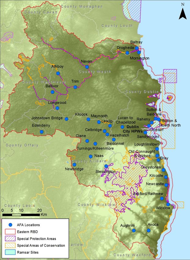
Copyright

Copyright - Office of Public Works. All rights reserved. No part of this report may be copied or
reproduced by any means without prior written permission from the Office of Public Works.

Legal Disclaimer

This report is subject to the limitations and warranties contained in the contract between the
commissioning party (Office of Public Works) and RPS Group Ireland

                                                                              rpsgroup.com/ireland
Eastern CFRAM Study                                                                                                Constraints Report - DRAFT

                                          TABLE OF CONTENTS
1       INTRODUCTION ........................................................................................................................ 1
2       KEY PLAN ELEMENTS TO BE ASSESSED ............................................................................ 2
3       KEY ENVIRONMENTAL ISSUES TO BE EXAMINED ............................................................. 4
4       OVERVIEW OF POLICY CONTEXT ......................................................................................... 8
5       DRAFT SEA OBJECTIVES ..................................................................................................... 10
6       OVERVIEW OF CURRENT STATE OF THE ENVIRONMENT............................................... 13
        6.1        ENVIRONMENTAL BASELINE ............................................................................................ 16
                   6.1.1       Biodiversity, Flora & Fauna ............................................................................ 16

                   6.1.2       Population & Human Health ........................................................................... 21

                   6.1.3       Geology, Soils & Landuse .............................................................................. 24

                   6.1.4       Water .............................................................................................................. 28

                   6.1.5       Air ................................................................................................................... 38

                   6.1.6       Climate ........................................................................................................... 39

                   6.1.7       Material Assets ............................................................................................... 41

                   6.1.8       Cultural, Archaeological & Architectural Heritage .......................................... 43

                   6.1.9       Landscape & Visual Amenity.......................................................................... 45

                   6.1.10 Amenity, Tourism and Recreational Use ........................................................ 47

                   6.1.11 Fisheries Aquaculture & Angling .................................................................... 49

7       REFERENCES ......................................................................................................................... 53

IBE0600Rp00035                                                          i                                                                     Rev D01
Eastern CFRAM Study                                                                                 Constraints Report - DRAFT

                                           LIST OF FIGURES
Figure 6.1       Sites with International Environmental Designations ................................................... 18

Figure 6.2       Sites with National Environmental Designations .......................................................... 19

Figure 6.3       Population Density (population/km²) by Small Area from 2011 Census ...................... 22

Figure 6.4       Current Geological Heritage Sites, Mines and Unproductive Aquifers......................... 26

Figure 6.5       Eastern RBD, UoMs / HAs and Water Management Units .......................................... 31

Figure 6.6       Current WFD Status of Eastern RBD Waterbodies ...................................................... 33

Figure 6.7       Distribution of Catchments at risk of not meeting WFD Objectives .............................. 34

Figure 6.8       Fisheries and Ports in Eastern RBD ............................................................................. 52

                                            LIST OF TABLES
Table 2.1    Proposed Elements of the Plan to be Assessed ................................................................. 2

Table 3.1    Key Environmental Issues to be Examined in SEA ............................................................. 4

Table 4.1    Summary of Key Plans, Programmes and Legislation Relevant to the FRMPs ................. 8

Table 6.1    Summary of Proposed Environmental Baseline Data and Sources .................................. 13

Table 6.2    Land Cover Area and percentage in the Eastern RBD ..................................................... 25

                                                APPENDICES

APPENDIX A                  Plans, Programmes and Legislation                                                     32 Pages

IBE0600Rp00035                                                 ii                                                         Rev D01
Eastern CFRAM Study                                                           Constraints Report - DRAFT

                                              ACRONYMS

AA               Appropriate Assessment
AFA              Area for Further Assessment
CAFE             Clean Air for Europe [Directive]
CFRAM            Catchment Flood Risk Assessment and Management
FRMP             Flood Risk Management Plan
DAFM             Department of Agriculture, Food and the Marine
DAHG             Department of Arts, Heritage and the Gaeltacht
DCENR            Department of Communications, Energy and Natural Resources
DECLG            Department of Environment, Community and Local Government
DoEHLG           Department of Environment Heritage and Local Government (now DECLG)
ERBD             Eastern River Basin District
EPA              Environmental Protection Agency
FEMFRAM          Fingal East Meath Flood Risk Assessment and Management Study
FPM              Freshwater Pearl Mussel
FRA              Flood Risk Assessment
FRMP             Flood Risk Management Plan
GSI              Geological Survey of Ireland
HA               Hydrometric Area
HPW              High Priority Watercourse
IFI              Inland Fisheries Ireland
LA               Local Authority
LAP              Local Area Plan
MCA              Multi-Criteria Analysis
MIDA             Marine Irish Digital Atlas
MPA              Marine Protected Area
MPW              Medium Priority Watercourse
NBiRBD           Neagh Bann International River Basin District
NWiRBD           North Western International River Basin District
OD               Ordnance Datum
OPW              Office of Public Works
OSi              Ordnance Survey Ireland
OSPAR            (Oslo Paris) Convention on the protection of North-East Atlantic marine environment
PFRA             Preliminary Flood Risk Assessment
RBD              River Basin District
SEA              Strategic Environmental Assessment
SERBD            South Eastern River Basin District

IBE0600Rp00035                                        iii                                       Rev D01
Eastern CFRAM Study                                                            Constraints Report - DRAFT

SWRBD            South Western River Basin District
SuDS             Sustainable Urban Drainage
UNESCO           United Nations Educational, Scientific and Cultural Organisation
UoM              Unit of Management
WHO              World Health Organisation
WRBD             Western River Basin District

IBE0600Rp00035                                     iv                                            Rev D01

Eastern CFRAM Study                                                          Constraints Report - DRAFT

1 INTRODUCTION

This Constraint Report has been prepared for the Office of Public Works (OPW) in support of the
Strategic Environmental Assessment (SEA) Scoping Report for the Eastern Catchment-based Flood
Risk and Management (CFRAM) Study. In accordance with Section K2.2 of CFRAM Study Stage 1
Project Brief, this report comprises information from desk studies and preliminary site visits by the
team, which have been undertaken in order to identify issues that may be relevant to, or might impose
constraints on, the design and/or implementation of flood risk management measures in the Eastern
CFRAM study area.

The key topics under examination have been derived in accordance with the European Communities
(Environmental Assessment of Certain Plans and Programmes) Regulations 2004 [S.I. 435/2004] and
the Planning and Development (Strategic Environmental Assessment) Regulations 2004 [S.I.
436/2004], and their recent amendments of European Communities (Environmental Assessment of
Certain Plans and Programmes) (Amendment) Regulations 2011 [S.I. 200/2011] and the Planning and
Development (Strategic Environmental Assessment) (Amendment) Regulations 2011 [S.I. 201/2011].

IBE0600Rp00035                                   1                                             Rev D01
Eastern CFRAM Study                                                                     Constraints Report - DRAFT

2 KEY PLAN ELEMENTS TO BE ASSESSED

As part of the SEA scoping process, decisions need to be made as to what parts of the CFRAM
Studies and associated Flood Risk Management Plans (FRMPs) should be assessed and to what level
of detail. The purpose of the SEA is to provide a meaningful assessment of those parts of the plan
that may lead to significant environmental effects, in order to contribute to more transparent decision
making and to ensure the objective of integrating environmental considerations into plan making is
realised.

Table 2.1 sets out the proposed elements of the FRMP and identifies those which are to be assessed
as part of the SEA and why. This information is also provided in the SEA Scoping Report to generate
discussion during the SEA consultation process and will be subject to change based on the comments
received.

Table 2.1        Proposed Elements of the Plan to be Assessed

                      Draft FRMP Section                             Will this be assessed in the SEA?

   I    VOLUME I – FLOOD RISK MANAGEMENT PLAN                 See below

       Outlines the public and stakeholder consultation       No – This is a statement about the consultation
       and engagement undertaken throughout the               arrangements put in place. SEA consultation
  1
       National CFRAM Programme and other relevant            arrangements however may be incorporated into
       projects.                                              this.
                                                              No – This provides factual information about the
                                                              general environment in the area. Some of this
       Provides an overview of the catchment and coastal
  2                                                           information will however be included in the
       areas covered by the FRMP.
                                                              environmental report as environmental baseline
                                                              information.
       Describes the PFRA undertaken to identify the          No – This provides factual information about the
  3
       AFAs that are the focus of this FRMP.                  background to the study and Plan.
                                                              No – This provides factual information about the
       Details the existing and potential future flood        flood risk in the area. Some of this information will
  4
       hazard and risk in areas covered by the FRMP.          however be included in the environmental report
                                                              as environmental baseline information.
                                                              Yes – These Strategic Objectives will be
       Sets out the flood risk management objectives that     assessed within the environmental report, to test
  5
       define what the FMRP is trying to achieve.             the Plan Objectives compatibility with the SEA
                                                              Objectives.
       Describes the environmental assessments                No – This is a statement about the environmental
       undertaken to ensure that the FMRP complies with       assessments undertaken for the study and Plan.
  6    relevant environmental legislation to and inform the   This should however include guarantees that the
       process of identifying the suitable strategies that    Plan will comply with recommendations from the
       will, where possible, enhance the environment.         environmental assessments.
                                                              Yes – These will be the measures proposed to
       Sets out the strategy for managing flood risk in the
  7                                                           manage flood risk within the Areas for Further
       area covered by the FRMP.
                                                              Assessment.
                                                              No – This is a statement about future monitoring
       Outlines how the implementation of the FRMP will
                                                              and reporting for the Plan. This should include
  8    be monitored and reported, and then reviewed and
                                                              recommendations from the environmental
       updated at regular intervals.
                                                              assessments.

IBE0600Rp00035                                           2                                                  Rev D01
Eastern CFRAM Study Constraints Report - DRAFT
Draft FRMP Section Will this be assessed in the SEA?
APPENDIX A – Public and Stakeholder No – This provides factual information about the
A
Consultation Events and Participants. consultation events.
No – This provides factual information about the
APPENDIX B – Local Weightings for the Multi-
B background to the multi-criteria analysis scoring
Criteria Analysis.
methodology.
APPENDIX C – Description of the flood risk No – This provides factual information about the
C
management options. flood risk management options.
No – This is mapping of the predicted flood
II VOLUME II – FLOOD MAPS extents and risk in the Areas for Further
Assessment.
IBE0600Rp00035 3 Rev D01Eastern CFRAM Study Constraints Report - DRAFT
3 KEY ENVIRONMENTAL ISSUES TO BE EXAMINED
In accordance with S.I. 435 of 2004 as amended, consideration has been given to the type of
environmental effects, both positive and negative, that could be expected to arise from implementation
of the FRMPs in the eastern region. A draft of Table 3.1 was issued as part of early stakeholder
engagement and the current version reflects comments received to date. It is anticipated that this
table will evolve as the Eastern CFRAM Study and associated FRMPs develop and as a clearer
picture of the types of measures being considered and the receiving environment becomes fully
apparent.
Table 3.1 Key Environmental Issues to be Examined in SEA
Scoped In /
Topics Environmental Awareness Issues
Out of SEA
• Effects on protected areas: European (SACs, SPAs) e.g. Dublin
coastline SPAs, Wicklow Mountains National Park SPA and SAC,
Boyne Estuary SAC.
• Effects on flora and fauna, (including migratory bird species etc.)
• Effects on Freshwater Pearl Mussel (Margaritifera spp.) protected
areas and other populations of Freshwater Pearl Mussel - while
there are no Freshwater Pearl Mussel designated areas in the
Eastern district, the Derreen River, which is located adjacent in the
South Eastern district does contain Margaritifera.
• Effects on salmonids, other protected fish and shellfish species.
Biodiversity, Flora There are three designated salmonid rivers in the eastern region
& Fauna
In and three designated shellfish growing areas.
• Effect on annex species in non-annex habitats e.g. crayfish in
canals
• Effects on Ramsar sites, UWWTD sensitive waters, NHAs, pNHAs.
• Effects on sensitive habitats (i.e. peatlands, limestone habitats)
• Effects on wetlands
• Effects and opportunities on refuge for fauna
• Potential introduction of alien species and invasive species
• Potential for habitat loss and fragmentation
• Potential for interaction with Habitats Directive, i.e. Article 6
• Recreational use of water (e.g. bathing, fishing, canal use, sailing,
canoeing and kayaking)
• Developed areas in the east tend to be located on the coast or by
rivers, such as the Rivers Liffey, Dodder, or Dargle.
• Possible effects on tourism (e.g. navigation, fishing, water sports,
Population & sailing)
In
Human Health • Improving degraded sites affecting water quality
• Effects on connectivity of communities, both physical links and
communications.
• Include amenity value of natural environment e.g. river walks
• Effects on disadvantaged communities
IBE0600Rp00035 4 Rev D01Eastern CFRAM Study Constraints Report - DRAFT
Scoped In /
Topics Environmental Awareness Issues
Out of SEA
• Effects from drinking water abstraction (surface and groundwater)
• Effects on drinking water protected areas
• Effects on overall water quality, including municipal and private
drinking water supplies
• Effects from invasive species (e.g. Giant Hogweed)
• Effects on contact water sports
• Effects related to flooding of septic tanks and waste water
treatment plants
• Include health value of natural environment e.g. river walks
• Effects of disturbing rodents during works near water
• Land vulnerable to erosion
• Erosion and soil function
• Effects on coastal erosion
• Influence on land use practices (e.g. fertiliser application)
• Effects of less frequent flooding on soil quality
• Effects on geomorphology (i.e. river channels, landforms)
• Effects on areas where sewage sludge is spread as fertilizer
Geology, Soils
In Effects in relation to peat slides
and Landuse •
• Effects on increased drainage on soils
• Effects on caves and potholes
• Effects on groundwater table and contamination of groundwater
• Change in land use based on risk to water quality, quantity and
flooding thus reducing value of land either by limiting development
potential or requiring a change in land use.
• Effects on access to lands
• Pressures and impacts on ecological status of water bodies
• Morphological impacts on water bodies from engineering and other
works, Rivers Dodder, Liffey and Vartry, are all subject to flow
regulation.
• Impacts on water supply (including potable) and water
Water In conservation
• Potential to improve water body status, including heavily modified
and artificial water bodies. Examples of heavily modified water
bodies include impoundments such as the Poulaphouca Reservoir
and Dublin Port on the Liffey Estuary.
• Effects of upstream storage on water quality.
• FRMPs unlikely to have significant effects on Air (or odour), with
only short term impacts of measures being identified. Due to the
lack of potential issues with Air, and in line with all other CFRAM
Air Out studies in Ireland, the Air topic is proposed to be scoped out of the
SEA process and will not be assessed within the environmental
report.
Climatic Factors In • Climate change mitigation and adaptation, including effects from
IBE0600Rp00035 5 Rev D01Eastern CFRAM Study Constraints Report - DRAFT
Scoped In /
Topics Environmental Awareness Issues
Out of SEA
severe weather events and coastal zone management
• Effects on sea level rise and maintenance of sea defences
• Protection of water-related assets
• Sustainable use of water (link to water receptor)
• Effects on potential future demand for food/biofuel production
• Effects on energy, telecommunications infrastructure, residential
and commercial properties, farm assets, personal property
• Effects on shipping and ports; traffic and transportation, roads,
railways lines, light houses, airports.
Material Assets & • Effects on individual risk receptors that can affect large numbers of
Infrastructure
In people, for example, hospitals, garda stations, banks.
• Effects on wind farms should be considered
• Effects on irrigation
• Effects on landfills
• Effects on agriculture and crops
• Secondary costs associated with flooding of infrastructure
• Opportunities for uses of poorer agricultural lands
• Effects on Bord na Mona assets
• Nationally designated sites and monuments within an appropriate
distance of water bodies (distance to be confirmed during FRMP
development)
• Effects on water-based archaeological features
• Effects on cultural heritage features in the vicinity of floodplains
and/or watercourses (i.e. mills, mill races, weirs and bridges)
• Effects on key national sites e.g. Battle of the Boyne site, Brú na
Bóinne Visitor Centre, Newgrange and Knowth
• Effects on historic landscapes
• Effects on cultural-scapes
Cultural,
Architectural & • Effects on historic ford crossings
In
Archaeological • Effects on industrial and engineering archaeology. Most notable
Heritage within the Eastern district are the engineering complexes of the
Grand and Royal Canals, and the Boyne Navigation, as well as the
structures, lighthouses and breakwaters of Dublin Port and Dún
Laoghaire.
• Potential for disturbance of previously undiscovered archaeological
remains near or within water bodies during development of water-
related infrastructure (e.g. wastewater treatment facilities, flood
defences, crossings). For example much of Ireland’s inshore
cultural marine heritage is unrecorded.
• Effects on areas of architectural significance
• Effects on locally important buildings
• Effects on areas of designated landscape quality and scenic views
Landscape & (i.e. in CDPs and other plans), River Liffey, Curragh, Hill of Tara
In
Visual Amenity
• Effect on parks, gardens and designed landscapes
IBE0600Rp00035 6 Rev D01Eastern CFRAM Study Constraints Report - DRAFT
Scoped In /
Topics Environmental Awareness Issues
Out of SEA
• Effects on the general landscape as well as riverscapes,
lakescapes and seascapes
• Potential for positive impacts should be considered and targets of
improvement set
• Effects on historic landscapes
Amenity, Tourism • Effects on heritage assets that benefit tourism
and Recreational In • Effects on beaches and coastal areas
Use • Effects on tourism and recreational facilities
• Effects on fisheries and fish habitats
• Effects on fish migration
Fisheries and Effects on commercial, recreational and tourism fishing
In •
Angling
• Spread of invasive species
• Effects on aquaculture and shellfish production
Flood Related • Effects on connectivity of communities
Social or Socio- In • Effects on vulnerable social receptors, eg schools, hospitals,
Economic Issues nursing homes)
It should be noted that OPW have requested additional environmental topic areas to be included within
the environmental assessments for the FRMPs in Ireland that are not specified within the SEA
Directive. These environmental topic areas will be included within the environmental report and are as
follows:
• Amenity, Tourism and Recreational Use;
• Fisheries and Angling, and
• Flood Related Social or Socio-Economic Issues.
IBE0600Rp00035 7 Rev D01Eastern CFRAM Study Constraints Report - DRAFT
4 OVERVIEW OF POLICY CONTEXT
As part of the SEA process the context of the Eastern CFRAM study must be established with regard
to other plans and programmes that have been adopted at International, European and National
levels. In particular the interaction of the environmental protection objectives and standards included
within these plans and programmes with the Eastern FRMPs requires consideration.
Table 4.1 identifies the main significant environmental plans, programmes and legislation, adopted at
International, European Community or Member State level, which would be expected to influence, or
be influenced by, the Eastern FRMPs. While it is recognised that there are many plans, programmes
and legislation that will relate to the FRMPs it is considered appropriate to only deal with those
significant texts, to keep the assessment at a strategic level. More information on these plans,
programmes and legislation, along with their potential interaction with the FRMPs is given in Appendix
A of this report.
Table 4.1 Summary of Key Plans, Programmes and Legislation Relevant to the FRMPs
Level Plan / Programme / Legislation
EU Level • EU Floods Directive [2007/60/EC]
• A Blueprint to Safeguard Europe’s Water Resources [COM(2012)673]
• Bathing Water Directive [2006/7/EC]
• Birds Directive [2009/147/EC]
• Bonn Convention [L210, 19/07/1982 (1983)]
• Drinking Water Directive [98/83/EC]
• EIA Directive [85/337/EEC] [2014/52/EU]
• Environmental Liability Directive [2004/35/EC]
• Environmental Quality Standards Directive [2008/105/EC]
• EU Biodiversity Strategy to 2020 [COM(2011)244]
• European Landscape Convention [ETS No. 176]
• Groundwater Directive [80/68/EEC] and Daughter Directive [2006/118/EC]
• Habitats Directive [92/43/EEC]
• Marine Strategy Framework Directive [2008/56/EC]
• Nitrates Directive [91/676/EEC]
• Renewable Energy Directive [2009/28/EC]
• SEA Directive [2001/42/EC]
• Second European Climate Change Programme [ECCP II] 2005.
• Sewage Sludge Directive [86/278/EEC]
• Soils Thematic Strategy [COM(2006) 231]
• Urban Wastewater Treatment Directive [91/271/EEC]
• Water Framework Directive [2000/60/EC]
• World Heritage Convention [WHC-2005/WS/02]
IBE0600Rp00035 8 Rev D01Eastern CFRAM Study Constraints Report - DRAFT
National Level • Arterial Drainage Maintenance and High Risk Designation Programme 2011-
2015 (OPW, 2011)
• Fisheries Acts 1959 to 2007 (S.I. No. 14 of 1959 and No. 17 of 2007)
• Harnessing Our Ocean Wealth: An Integrated Marine Plan for Ireland (Inter-
Departmental Marine Coordination Group 2012)
• Irish Geological Heritage (IGH) Programme (GSI 1998-)
nd
• National Biodiversity Plan (2 Revision 2011-2016) (DAHG, 2011)
• National Climate Change Strategy 2007-2012 (DEHLG, 2007)
• National Landscape Strategy for Ireland (Draft) 2014 – 2024 (DAHG, 2014)
• National Monuments Acts (1930 to 2004) (S.I. No. 2 of 1930 & No. 22 of 2004)
• National Renewable Energy Action Plan (DCENR, 2010)
• National Spatial Strategy 2002-2020 (DELG, 2002)
• Planning System and Flood Risk Management (OPW, 2009)
• Raised Bog SAC Management Plan (Draft) (DAHG, 2014),
• National Peatland Strategy (Draft) (NPWS, 2014)
• Review of Raised Bog Natural Heritage Area Network (NPWS, 2014)
• Report of the Flood Policy Review Group (OPW, 2004)
Regional Level • Flood Risk Management Plans
• River Basin Management Plans
• Regional Planning Guidelines
• Regional Development Strategies/Plans
• Groundwater Protection Schemes
Sub-Regional • County and Town Development Plans
• County Landscape Character Assessments
• County Renewable Energy Strategies
• Economic development plans for rural and urban areas
• Freshwater Pearl Mussel Sub-Basin Management Plans
• Greater Dublin Strategic Drainage Strategy
• Heritage Plans
• Housing Strategies
• Local Area Plans
• Local Biodiversity Action Plans
• Local Catchment Flood Risk Management Plans
• Planning Schemes for Strategic Development Zones (SDZ)
• Shellfish Pollution Reduction Programmes
• Sludge Management Plans
• Special Amenity Area Orders
• Water Quality Management Plans
IBE0600Rp00035 9 Rev D01Eastern CFRAM Study Constraints Report - DRAFT 5 DRAFT SEA OBJECTIVES The FRMP objectives and the shortlisted Flood Risk Management (FRM) Options will be assessed against the SEA Objectives to examine the likely significant environmental impacts of the draft FRMPs. This assessment should be relatively strategic, with the aim of reporting likely impacts at the Unit of Management (UoM) level to reflect the scale at which the Plans are set. These Objectives will be used to assess the FRM Options and will feed directly into the Multi-Criteria Analysis (MCA) being undertaken. This MCA will consider the issues of social and environmental impacts alongside the technical and economic criteria. The MCA framework has been developed to take account of the broader range of issues relevant to delivery of the FRMP in the development and selection of FRM Options, and their subsequent prioritisation. The draft SEA Objectives and Sub-Objectives to be used within the MCA are given in Table 5.1. The SEA will include two additional objectives for the environmental assessment, which are not currently within the MCA objectives. These objectives are given in Table 5.2 and will cover the environmental topics of Soil and Climatic Factors. These objectives were incorporated into an earlier pilot SEA for the Dodder FRMP in Ireland. IBE0600Rp00035 10 Rev D01
Eastern CFRAM Study                                                                                                                        Constraints Report - DRAFT

Table 5.1:       Draft SEA Objectives

     Criteria                                Objective                                                              Sub-Objective

                                                                                   i)    Minimise risk to human health and life of residents
                      A   Minimise risk to human health and life
                                                                                   ii)   Minimise risk to high vulnerability properties
 Social
                                                                                   i)    Minimise risk to social infrastructure and amenity
                      B   Minimise risk to community
                                                                                   ii)   Minimise risk to local employment

                                                                                         Provide no impediment to the achievement of water body objectives
                      C   Support the objectives of the WFD                        i)
                                                                                         and, if possible, contribute to the achievement of water body objectives.

                                                                                         Avoid detrimental effects to, and where possible enhance, Natura 2000
                      D   Support the objectives of the Habitats Directive         i)    network, protected species and their key habitats, recognising relevant
                                                                                         landscape features and stepping stones.
                                                                                         Avoid damage to or loss of, and where possible enhance, nature
                          Avoid damage to, and where possible enhance, the
                      E                                                            i)    conservation sites and protected species or other know species of
                          flora and fauna of the catchment
                                                                                         conservation concern.

                                                                                         Maintain existing, and where possible create new, fisheries habitat
 Environmental            Protect, and where possible enhance, fisheries
                      F                                                            i)    including the maintenance or improvement of conditions that allow
                          resource within the catchment
                                                                                         upstream migration for fish species.

                                                                                         Protect, and where possible enhance, visual amenity, landscape
                          Protect, and where possible enhance, landscape
                      G                                                            i)    protection zones and views into / from designated scenic areas within
                          character and visual amenity within the river corridor
                                                                                         the river corridor.
                                                                                         Avoid damage to or loss of features, institutions and collections of
                          Avoid damage to or loss of features, institutions and    i)
                                                                                         architectural value and their setting.
                      H   collections of cultural heritage importance and their
                          setting                                                        Avoid damage to or loss of features, institutions and collections of
                                                                                   ii)
                                                                                         archaeological value and their setting.

IBE0600Rp00035                                                                11                                                                           Rev D01
Eastern CFRAM Study Constraints Report - DRAFT
Table 5.2: Additional Draft SEA Objectives
Minimum Aspirational
Criteria Objective Sub-Objective Indicator
requirement target
Avoid increase in flood risk to
Climatic other areas due to flood risk No non-intentional Intentional
No increase in flood risk to Other areas at risk
Factors I i) management options taking increase in flood decrease in flood
other areas from flooding
the possible impacts of risk to other areas risk to other areas
climate change into account
Geology, Soils No increase in Reduction in area
Area at risk from
and Landuse J Protect soil function i) Avoid loss of soil from erosion area at risk from at risk from
flooding
flooding flooding to zero
IBE0600Rp00035 12 Rev D01Eastern CFRAM Study Constraints Report - DRAFT
6 OVERVIEW OF CURRENT STATE OF THE ENVIRONMENT
The SEA Environmental Report will expand on the existing information and contain a full description of
the Environmental Baseline data within the study area. The key baseline information intended to be
used are detailed in Table 6.1. It is proposed that much of the baseline information will be presented
in the form of maps, diagrams and graphs, with supporting text in the Environmental Report. It is
important that only data directly relevant to the FRMPs are included within the SEA.
Table 6.1 Summary of Proposed Environmental Baseline Data and Sources
Environmental Baseline Data Data Sources
Biodiversity, Flora and Fauna
NPWS & EPA data:
• SACs & Water Dependent SACs
• SPAs & Water Dependent SPAs
• NHAs & pNHAs
• Ramsar Sites
• Freshwater Pearl Mussel Catchments & Sensitive Areas
Location and Condition of • Nature Reserves
Designated Sites • Wildfowl Sanctuaries
• Nutrient Sensitive Areas
• Shellfish Areas
• Salmonid Lakes and Rivers
Birdwatch Ireland data:
• IWeBs Keysites
OSPAR data:
• Marine Protected Areas
Current threats to Biodiversity Biodiversity Ireland data:
• Invasive Species records
Population & Human Health
Numbers of Population and CSO data:
Occupancy • Census Small Areas
Numbers and Locations of HSE data:
Health Care Services • Hospitals
• Health Centres
Geology, Soils & Landuse
GSI & EPA data:
• Bedrock & Aquifers
Soil and Geological Features • Soil & Subsoil type/permeability/vulnerability
• Active Quarries & Historic Mines
• Geological Heritage Sites
• Landslide locations
Landuse NPWS, EPA & GSI data:
• CORINE landcover
IBE0600Rp00035 13 Rev D01Eastern CFRAM Study Constraints Report - DRAFT
Environmental Baseline Data Data Sources
• Ancient and Established Woodland
• Native Woodland
Water – Surface water, Groundwater, Coastal & Estuarine
EPA & WFD data:
Locations, Status and Risk of • WFD Management Units
Water Bodies • Ecological status and risk of surface, coastal and transitional
water bodies
• Rivers and lakes
Air & Climatic Factors
Air Quality Information & Zones EPA data:
• National Ambient Air Quality Network
General climatic summary Met Éireann regional information.
Data collected for CFRAM Study.
Climatic change information Data collected and calculated for CFRAM Study.
Material Assets & Infrastructure
NRA data:
• Roads
DAFFT, Iarnrod Eireann & IAA data:
• Ports and Harbours
• Rail
• Airports
Civil Defence, DEHLG & OPW data:
Number and Type of • Civil Defence HQs
Infrastructure • Fire Stations
• Garda Stations
EPA & WFD data:
• IED Sites
• Water Treatment and Waste Water Treatment Plants
• Landfills
• Drinking Water
Data collected for CFRAM Study
Eircom & ESB data:
Energy and Renewable Energy • Telephone Exchanges
Locations and Status • Power stations and Substations
AIRO data:
• Wind Farms
Cultural, Archaeological & Architectural Heritage
DEHLG, NIAH & NPWS data:
• Record of Monuments
Location and Status of • NIAH Buildings
Protected Sites • UNESCO World Heritage Sites
INFOMAR data:
• Shipwrecks
Landscape & Visual Amenity
IBE0600Rp00035 14 Rev D01Eastern CFRAM Study Constraints Report - DRAFT
Environmental Baseline Data Data Sources
Landscape Character Areas Information from CDPs:
and Sensitive Landscapes • Landscape Conservation Areas
Amenity, Tourism and Recreational Use
NPWS & WFD data:
Location of Designated Sites • National Parks
• Bathing Waters
OPW data:
• Galleries, Museums & Theatres
Irish Sports Council data:
• Trails
Locations of Amenities DECLG data:
• Social Amenity Areas
EPA data:
• Designated Bathing Waters
Data collected for CFRAM Study
Fisheries & Angling
MIDA & IFI data:
• Ports
Locations for Fishing and • Fishing Spots
Species • Angling spots
EPA data:
• Salmon lakes/rivers
• Inshore Fisheries – Aquaculture
Flood Related Social or Socio-Economic Issues
DoE & Higher Education Authority data:
Numbers and Locations of • Primary Schools
Educational Institutions • Post Primary Schools
• Third Level Institutions
Numbers and Locations of Care HSE data:
Facilities • Nursing Homes
• Residential Care for the Elderly
It is key that the current state of the environment be described using the most recent and up-to-date
environmental data, information and reports. Where updates of significant environmental data and
associated reports become available during the SEA process, consideration should be given to
incorporating the new information into the description of the current state of the environment. Where
data gaps are found for particular aspects of the current state of the environment, the significance of
these data gaps should be clearly stated. In addition, it should be stated whether these gaps can be
reasonably and realistically addressed during the SEA process. A preliminary environmental baseline
for the Eastern CFRAM study region is included below in Section Error! Reference source not found..
IBE0600Rp00035 15 Rev D01Eastern CFRAM Study Constraints Report - DRAFT
6.1 ENVIRONMENTAL BASELINE
Included in the following section of this Constraints Report is a preliminary discussion of the
environmental baseline for the Eastern CFRAM study area. The preliminary baseline has been
divided by topic into the issues requiring assessment under the SEA legislation, including additional
topic areas requested by OPW. Further detailed baseline studies, with all associated mapping, will be
developed as part of the Environmental Report to follow this scoping phase. The purpose of the
following section is to demonstrate the level of baseline environmental information to be used in the
assessment of potential impacts of the Plan FRM Options. This baseline information will form the
indicators which the FRM Options will have the potential to impact upon. Future variation in these
indicators due to the FRMPs will be monitored as part of the Plan and SEA review.
6.1.1 Biodiversity, Flora & Fauna
The Eastern CFRAM study area is of high ecological value, with a variety of habitats and species of
conservation concern which are protected under a number of European and national designations.
Areas which have been designated for the protection of habitats and species include the following:
• Special Areas of Conservation (SACs) are designated in accordance with the Habitats
Directive (92/43/EEC) for the conservation of certain habitats and species and protected by
the European Communities (Birds and Natural Habitats) Regulations 2011. Together with
SPAs these European Sites form part of the Natura 2000 Network. There are 34 SACs in the
Eastern CFRAM study area of which 12 are classed as “water dependent” SACs. The SACs in
the Eastern CFRAM study area are shown in Figure 6.1;
• Special Protection Areas (SPAs) are designated under the EU Birds Directive (79/409/EEC)
for the protection of birds of conservation concern and protected by the European
Communities (Birds and Natural Habitats) Regulations 2011. Together with SACs these
European Sites form part of the Natura 2000 Network. There are 18 SPAs in the Eastern
CFRAM study area, of which five are classed as “water dependent” SPAs. The SPAs in the
Eastern CFRAM study area are shown in Figure 6.1;
• Natural Heritage Areas (NHAs) are designated under the Wildlife Act (1976 - 2000) as they
are considered important habitats which support animals or vegetation of importance. There
are nine NHAs in the Eastern CFRAM study area. There are a further 94 proposed Natural
Heritage Areas (pNHA) in the study area, which were published on a non-statutory basis in
1995, but have not since been statutorily proposed or designated. pNHAs are subject to
limited statutory protection, but are recognised for their ecological value by planning and
licensing authorities. The NHAs and pNHAs in the Eastern CFRAM study area are shown in
Figure 6.2;
IBE0600Rp00035 16 Rev D01Eastern CFRAM Study Constraints Report - DRAFT
• Ramsar Sites are designated under the Convention on Wetlands of International Importance
for the protection of wetland areas (which are important feeding habitats for birds). All Ramsar
sites are also recognised as SPA and/or SAC areas and so are afforded protection by the
European Communities (Birds and Natural Habitats) Regulations 2011. There are six Ramsar
sites in the Eastern CFRAM study area. The Ramsar sites in the Eastern CFRAM study area
are shown in Figure 6.1;
• Wildfowl Sanctuaries are established under the Wildlife Act, 1976 and are excluded from the
‘Open Season Order’ in which shooting of game birds is permitted. There are seven wildfowl
sanctuaries in Eastern CFRAM study area;
• National Parks are established under the International Union for the Conservation of Nature
and are areas identified as not materially altered by human exploitation and occupation and
where steps have been taken to prevent exploitation or occupation in respect of ecological,
geomorphological or aesthetic features. There is one national park in the Eastern CFRAM
study area;
• Nature Reserves are identified as being important habitats to support wildlife and are
protected under Ministerial Order. There are nine nature reserves in the Eastern CFRAM
study area;
• Freshwater Pearl Mussel Catchments and Sensitive Areas. The Freshwater Pearl Mussel
(FPM) is an endangered bivalve which lives in fast-flowing, clean rivers. As filter feeders,
freshwater pearl mussels are extremely vulnerable to water pollution and engineering work in
rivers such as the construction of weirs or deepening of pools. The species Margaritifera
margaritifera and Margaritifera durrovensis are protected under the Habitats Directive
(92/43/EEC) and the Wildlife Acts (1976, amended 2000). There are no FPM catchments in
the Eastern CFRAM study area, however there are five areas identified as being sensitive,
which are either sites with previous records of Margaritifera, but their current status is
unknown, or are catchments of other extant populations;
• OSPAR Marine Protected Areas (MPA) are sites identified under the OSPAR Convention to
protect the marine environment of the North East Atlantic. Ireland has identified a number of
its SACs as OSPAR MPAs for marine habitats. There are two OSPAR MPAs in the Eastern
CFRAM study area.
IBE0600Rp00035 17 Rev D01Eastern CFRAM Study Constraints Report - DRAFT Figure 6.1 Sites with International Environmental Designations IBE0600Rp00035 18 Rev D01
Eastern CFRAM Study                                                          Constraints Report - DRAFT

Figure 6.2       Sites with National Environmental Designations

The biodiversity value of much of the Eastern CFRAM study area has been recognised, with a
significant proportion of the catchment designated as of European or national importance. Many of the

IBE0600Rp00035                                   19                                            Rev D01
Eastern CFRAM Study                                                              Constraints Report - DRAFT

SAC and SPA designated areas are on or adjacent to estuaries, such as Malahide Estuary, North and
South Dublin Bay, the Boyne Coast and Estuary, Baldoyle Bay and Rogerstown Estuary. The shallow
mudflats and sandflats in these estuaries provide important feeding habitats for wintering waterfowl
and inshore islands such as Ireland’s Eye and Lambay Island support large populations of breeding
seabirds.    The River Boyne and Blackwater has salmon, otter and lamprey among its qualifying
species

Many of the inland environmental designations are for areas of bog or peatland, which are also
important biodiversity assets. Intact bogs, which are actively forming peat, play a significant role in
combating climate change by removing excess carbon dioxide from the air and placing it into long term
storage for thousands of years. They purify water and reduce flooding by their capacity to absorb,
hold and slowly release water. Conserving or restoring bogs is a positive action for climate change
mitigation, water quality and flood relief.

Non-native, invasive species are a particular threat to the native flora and fauna of the Eastern
CFRAM study area. Dublin City Council, with the assistance of the Heritage Council, undertook a
survey of invasive plants in 2009 city-wide to determine the extent of invasive species in Dublin. It
found the most problematic areas are along the river valleys, however coastal are also at risk from
aggressive plants such as Hottentot Fig (Carpobrotus edulis), which is an aggressive invader of
coastal habitat. As these non-native species, particularly plants, could be spread by flooding or flood
risk management measures, they therefore require appropriate mitigation and control strategies.

Future Trends

In the future, it is likely that there will be benefits to both protected sites and species, and the wider
aquatic environment, with the implementation of measures to achieve good ecological status or
potential under the WFD.

In addition, the continued development of specific biodiversity action plans under the National
Biodiversity Plan and related plans should provide a framework for protecting these increasingly
threatened habitats and species.

Changes in land use, such as increasing urbanisation, afforestation or changing agricultural practices,
will continue to threaten biodiversity within the Eastern CFRAM study area, both within and outside of
the designated sites.

Key Issues

    •     Consideration of effects of flood risk management measures on SACs, SPAs, NHAs,
          (including proposed NHAs) and other designated nature conservation sites and National Parks
          within the Eastern CFRAM study area, in addition to those outside the study area that may be
          impacted by proposals within in;

IBE0600Rp00035                                     20                                              Rev D01
Eastern CFRAM Study Constraints Report - DRAFT
• Where there is a potential risk to European Sites (SPAs and SACs) from the implementation of
measures, it will be necessary to undertake appropriate assessment in accordance with the
Birds and Natural Habitats Regulations to ensure that adverse impacts on these sites will not
arise;
• Consideration must also be given to effects on flora and fauna, such as migratory bird species
and invertebrates or sensitive habitats in areas which do not hold designations, to avoid
habitat fragmentation or loss;
• Freshwater Pearl Mussel, Atlantic Salmon and Lamprey species are particularly sensitive to
pollution and in-channel flood risk management measures; while there are no areas
designated for FPM in the ERBD there may be connectivity with designated areas in adjacent
catchments. Other protected fish and shellfish species may also be affected by flood risk
management measures;
• Changes to the flooding regime may have effects on sensitive habitats, e.g. bogs, fens,
peatlands, limestone habitats or wetland areas;
• Changes to the flooding regime can adversely impact upon biodiversity, through nutrient
enrichment, detrimental impacts on water quality, siltation and community changes;
• Implementation of flood risk management measures can also contribute towards the spread of
invasive/non-native species if not properly managed.
6.1.2 Population & Human Health
The 2011 census data held by the Central Statistics Office (CSO, 2011) show a total population for the
Eastern CFRAM study area of approximately 1.83 million, of which 1.18 million are in County Dublin
and 0.5 million in Dublin City. Population has increased in County Dublin by around 7.2% since the
previous census in 2006, with counties Offaly (+8.2%), Wicklow (+8.3%), Westmeath (+8.6%), Kildare
(+12.9%), Louth (+13.1%), Meath (+13.1%), and Cavan (+14.3%) also recording significant population
growth over the same period. The population density by electoral division for the Eastern CFRAM
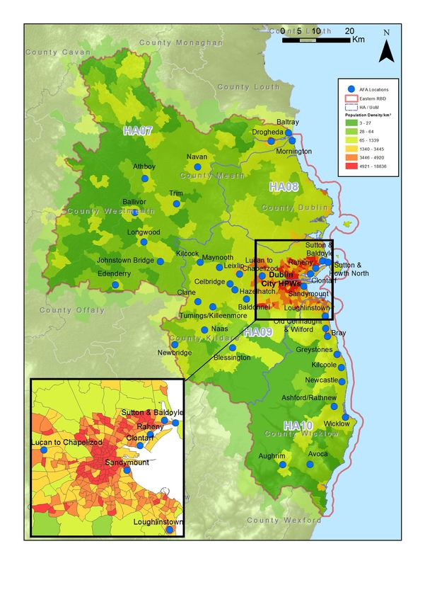
Study area is shown in Figure 6.3 (CSO, 2011).
IBE0600Rp00035 21 Rev D01Eastern CFRAM Study Constraints Report - DRAFT Figure 6.3 Population Density (population/km²) by Small Area from 2011 Census The census also revealed the high rates of emigration which have occurred during the economic downturn following the previous census, with a decrease of 12% since 2006 in the population of 19-24 year olds. The CSO confirmed that emigration plays a significant role in the diminishing young population, with around 30,000 young people aged between 15 and 24 leaving the country each year to seek work elsewhere. This has left behind a population with a higher proportion of aging (>65) people and particularly young people (
Eastern CFRAM Study                                                                             Constraints Report - DRAFT

The population of pre-school children has increased by 18%, which is up 50% since the last census
                                                1
was conducted and a Eurostat report quotes Ireland as currently having the highest proportion of
under-15s in Europe, at 22%. The report speculates that the growing gap between old and young
populations in the wider EU could result in labour market shortages and an increased burden
supporting the remainder of the population.

The number of older people (aged over 65) has increased by 14% since the last census, and there are
greater numbers of older people now living in nursing homes (20,000) and residential hospitals
(5,000). The data has also showed a 7% increase in the number of young adults (19-24) living in the
family home rather than moving out.

More detailed population figures from publications including the 2011 Census will be used to inform
the baseline description of population in the SEA.

In terms of human health, impacts relevant to the SEA are those which arise as a result of interactions
with environmental vectors (i.e. environmental components such as air, water, food or soil through
which contaminants or pollutants, which have the potential to cause harm, can be transported so that
they come into contact with human beings). Hazards or nuisances to human health can arise as a
result of exposure to these vectors, for example from incompatible adjacent land uses. These issues
are also discussed in the Material Assets (6.1.7) Soils, Geology and Land Use (6.1.3) and Water
(6.1.4) sections.

Future Trends

The population trend within the Eastern CFRAM study area is generally one of increasing growth,
broadly matching the national average growth through the last census period of around 8.1%, although
the counties adjacent to Dublin are experiencing greater rates of up to 14%. There will be ongoing
population pressure on infrastructure and resources and the provision of adequate health care
resources for the expanding population, particularly in terms of the expansion of the aging and young
populations that are not economically active.

Key Issues

       •    Ongoing population growth for all counties and cities within the Eastern CFRAM study area
            creating increasing pressures on water resources, e.g. quality of water supply for drinking
            water abstraction (including private supplies as well as municipal treatment) and waste water
            treatment;

       •    Interactions with public use of waterbodies (e.g. bathing, fishing, leisure craft, sailing,
            watersports);

1
    Eurostat (2015) “What it Means to be Young in the European Union Today” Facts and Figures on Youth and Children in the EU

IBE0600Rp00035                                                23                                                    Rev D01
Eastern CFRAM Study Constraints Report - DRAFT
• Population centres in the east tend to be located on the coast or by rivers, such as the Rivers
Liffey, Dodder and Dargle;
• Certain invasive species (e.g. giant hogweed) can be harmful to human health (relationship
with biodiversity).
6.1.3 Geology, Soils & Landuse
The geology of the Eastern River Basin District (ERBD) consists of a Palaeozoic stratigraphy ranging
in age from Cambrian to Namurian (Carboniferous), containing 15 of the 28 bedrock groups
represented on the national bedrock map. The older rocks occurring in the southern portion of the
ERBD (HA10 and part of HA09) are predominantly metasediments of Cambrian, Ordovician and
Silurian age and an extensive area of granites and other igneous intrusive rocks from the Caledonian
Orogeny. These granites and surrounding metasediments comprise the principal upland massif within
the ERBD and underlie all the river basins in this portion of the ERBD. A belt of Silurian
metasediments also occurs along the northern border of the ERBD in the north of HA07. Younger
Carboniferous (Dinantian and some Namurian) sedimentary rocks (54% of the ERBD) underlay a
majority of the ERBD’s low-lying areas. These sedimentary rocks are predominantly composed of
limestones (ERBD - 39% impure limestones and 11% pure limestones) with a residue (4%) of
sandstones, shales or undifferentiated sedimentary strata.
The SEA will consider published national data on important geological features. The GSI and the
DAHG are currently identifying sites of geological interest across the country that will be proposed as
Natural Heritage Areas. There have been 45 such sites identified so far within the Eastern CFRAM
study area, for features as diverse as granite pillars, mine workings and glacial features.
There are 23 mines within the Eastern CFRAM study area, mainly in the Avoca, Ballycorus and
Glendalough areas, whose target minerals are generally copper and lead, but also recover quantities
of sulphur, zinc, barium and silver.
Figure 6.4 demonstrates the distribution of the Irish Geological Heritage sites, the mines and the
areas of unproductive aquifers in the Eastern CFRAM study area. These poorly productive aquifer
areas can indicate areas of reduced infiltration and rejected groundwater recharge, which could
contribute to flood risk.
To date, there is no legislation in Ireland which is specific to the protection of soil resources. However,
there is currently an EU Thematic Strategy on the protection of soil which includes a proposal for a Soil
Framework Directive, including the proposal of common principles for protecting soils across the EU.
Soils have the potential to be impacted upon by implementation of flood risk management measures
and will be considered by the assessment.
IBE0600Rp00035 24 Rev D01Eastern CFRAM Study Constraints Report - DRAFT
The most predominant soil types in the ERBD are Grey brown podzolics, gleys, acid brown earths and
brown podzolics. Grey brown podzolics, gleys, and acid brown earths are found in the lowlands. These
types are naturally fertile and well suited for productive agriculture. Basin peats are widespread and
represent the eastern margin of the extensive occurrence of lowland basin peat across the Central
Plains of Ireland. Brown podzolics and peaty podsols are both located on the upper flanks, which are
particularly associated with the granites. Mountain top ridge zones typically contain high level blanket
peats and lithosols.
Land use directly affects the surface and groundwater environments through processes such as run
off, infiltration and abstraction. The broad pattern of land cover in the ERBD has been determined
from the CORINE Land Cover Database (2012) from which it can be seen that four land use types
dominate the ERBD. These are: agricultural, urban (artificial surfaces), natural areas (forests and
bogs), and coastal areas. The classification of land cover within the ERBD, based on the CORINE
scheme, is shown in Table 6.2 below.
Table 6.2 Land Cover Area and percentage in the Eastern RBD
Description Area (Km²) % of ERBD
Pastures 3,466 55
Non-irrigated arable land 837 13
Peat bogs 422 7
Discontinuous urban fabric 376 6
Coniferous forest 228 4
Land principally occupied by agriculture 207 3
Transitional woodland shrub 169 3
Complex cultivation patterns 82 1
Sport and leisure facilities 79 1
Moors and heathland 63 1
IBE0600Rp00035 25 Rev D01Eastern CFRAM Study Constraints Report - DRAFT Figure 6.4 Current Geological Heritage Sites, Mines and Unproductive Aquifers The Eastern CFRAM study area is the most highly urbanised basin district in Ireland, with discontinuous urban fabric covering 6% of the RBD, which includes the greater Dublin area. IBE0600Rp00035 26 Rev D01
Eastern CFRAM Study                                                               Constraints Report - DRAFT

Agricultural lands comprise over 70% of the ERBD with the majority used for pasture (55%) to graze
dairy cows, cattle, and sheep; however there are also large areas of arable land, used for the
production of grains, fruit, vegetables, poultry and pigs. Peat bogs also comprise a relatively large
portion of the RBD, covering around 7% of the land area. Two other substantial land features are the
Wicklow Mountains and the extensive coast along the Irish Sea. The Wicklow Mountains are located
in the southern portion of the basin and represent a relatively large contiguous area that remains in a
natural or semi-natural state. The coastline comprising the eastern boundary is approximately 200
miles long and includes various bays, estuaries, and portions of the Irish Sea.

Drainage of bog lands and peat extraction activities potentially lead to large quantities of peat silt being
discharged to the receiving waters. However, the waters draining the peat bog areas in HA09 are part
of the Pollaphuca catchment basin or upstream of the Glensamole Reservoirs at the upper reaches of
the Dodder. Therefore transport of peat silt is buffered by these lakes in terms of transfer of sediment
downstream and subsequent channel capacity and scour impacts.

The predominance of pasture over arable land suggests that, in general, the level of exposed soil is
limited within the RBD. However there are several pockets of arable land in close proximity to Eastern
CFRAM study watercourses. Depending on agricultural practices, farming of arable land can lead to
increased soil loss to receiving watercourses through ploughing and presence of exposed soils, which
will be exacerbated if environmental measures, such as buffer strips along river banks, are not
employed. Overgrazing of soils in commonage areas is also a source of exposed soils washing into
headwaters, increasing flashiness through more rapid run-off and erosion increased sediment load to
rivers resulting in increased deposition downstream. If an AFA is within a flashy catchment, this will be
taken into account in the assessment of options and in the environmental report. Flashy catchments
are characterised as responding very quickly to rainfall, with the flow of water rising rapidly to a high
peak before receding similarly. The environmental report will provide hydrographs and descriptions,
where necessary, of the characteristics that make the catchment flashy.

There are 293 areas of native woodland identified by the NPWS within the ERBD, covering an area of
over 18 km². There are also a further 35km² of ancient and long established woodlands across the
study area, many of which are in protected areas.

Future Trends

Land cover is dominated by agricultural pastureland; however urban areas also make a significant
portion of the study area. While it is unlikely that the general pattern of land use will be substantially
changed in the future, the increasing population will continue to drive a requirement for new housing
and expansion of developed areas.

Increases in population pose pressures on agriculture to increase productivity, which coincides with
the Irish agricultural industry also aiming to provide more goods to the global market. Land drainage

IBE0600Rp00035                                      27                                              Rev D01
You can also read