Aquatic Invasive Species Discipline Report
←
→
Page content transcription
If your browser does not render page correctly, please read the page content below
Attachment 8
Aquatic Invasive Species
       Discipline Report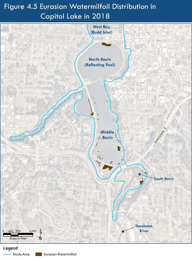
CAPITOL LAKE – DESCHUTES ESTUARY
       Long-Term Management Project    Environmental Impact Statement

Aquatic Invasive Species
   Discipline Report
                      Prepared for:

Washington State Department of Enterprise Services
                 1500 Jefferson Street SE
               Olympia, Washington 98501

                      Prepared by:

          Herrera Environmental Consultants, Inc.

                       June 2021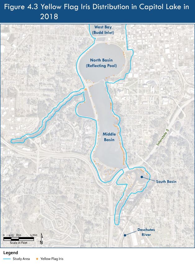
< Intentionally Blank >
CAPITOL LAKECAPITOL
                                                                                   – DESCHUTES   ESTUARY ESTUARY
                                                                                          LAKE – DESCHUTES
                                                                      Long-Term Management Project Environmental Impact Statement
                                                                                            Long-Term Management Project   Environmental Impact Statement

Executive Summary

This Aquatic Invasive Species Discipline Report describes the potential impacts of the Capitol Lake –
Deschutes Estuary Long-Term Management Project on aquatic invasive species in the area surrounding
the project. The Capitol Lake – Deschutes Estuary includes the 260-acre Capitol Lake Basin, located on
the Washington State Capitol Campus, in Olympia, Washington. Long-term management strategies
and actions are needed to address issues in the Capitol Lake – Deschutes Estuary project area. An
Environmental Impact Statement (EIS) is being prepared to document the potential environmental
impacts of various alternatives and determine how these alternatives meet the long-term objectives
identified for the watershed.

Aquatic invasive species (AIS) include nonnative plants and animals that rely on the aquatic
environment for a portion of their life cycle and can spread to new areas of the state, causing economic
or environmental harm. The impacts of construction and operation of each alternative are assessed
based on the potential of project alternatives to result in changes in abundance or distribution of AIS
within or outside the project area from AIS transport into or out of the project area. Where impacts are
identified, the report discusses measures that can be taken to minimize or mitigate potential impacts.
The analysis examines the No Action Alternative, as well as three build alternatives: Managed Lake,
Estuary, and Hybrid.

Under the No Action Alternative, Capitol Lake would remain closed to the public and AIS would
continue to be managed from containment and using methods aimed at maintaining low population
densities. The New Zealand mudsnail population is not likely to substantially increase within the lake or
move far outside the lake because it appears not to have done so in at least 10 years since its
introduction in 2009, based on the most recent survey in 2015 and lack of reported sightings outside the
lake since then. The containment of these AIS is a highly effective method of avoiding the spread
because of the absence of public access, which is the primary way that AIS are spread to new
waterbodies. In the absence of public access or meaningful intervention, the populations of other AIS
invertebrates, fish, waterfowl, and mammals would be expected to continue to expand within the basin
at current low rates. Based on this, under the No Action Alternative, the risk for AIS in Capitol Lake to
spread to otherwise non-invaded water bodies is expected to be less-than-significant.

June 2021                                  Aquatic Invasive Species                                                        Page ES-1
                                              Discipline Report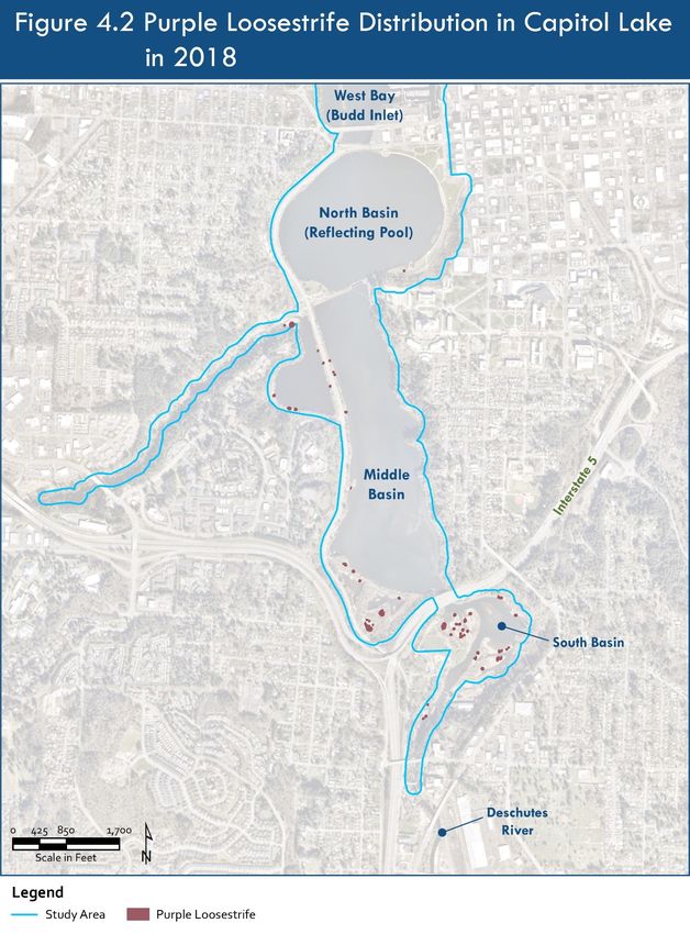
CAPITOL LAKE – DESCHUTES ESTUARY
                                                                       Long-Term Management Project Environmental Impact Statement

Prior to construction of all action alternatives, Capitol Lake would be treated to significantly reduce AIS
populations within the waterbody and reduce the risk of potential spread once construction activities
began. Management actions prescribed under an AIS Management Plan may include the use of
herbicides/pesticides to reduce the number of purple loosestrife seeds and live New Zealand mudsnails.
Under all build alternatives, areas of Capitol Lake would be dredged during construction and the dredge
sediment would be beneficially reused within the Capitol Lake Basin to create habitat areas. Reusing
the dredged material onsite is a key design feature that would further minimize the potential transport
of AIS outside the project area. Off-site transport of excess dredge material for the Estuary and Hybrid
Alternatives would require additional Best Management Practices (BMPs) or treatment to prevent the
spread of AIS in those materials.

The Estuary and Hybrid Alternatives include removing the 5th Avenue Dam, reintroducing saltwater to
the basin and creating a brackish environment. The introduction of saltwater would have a substantial
beneficial effect on freshwater AIS populations that are intolerant to higher salinities.. However,
despite early treatment of the Capitol lake Basin, there will remain a potential for AIS populations of
purple loosestrife and New Zealand mudsnails to spread outside the project area following the 5th
Avenue Dam removal given their tolerance of higher salinities. Because of this potential, construction
could have a significant impact on AIS distribution under the Estuary and Hybrid Alternatives,
compared to less-than-significant impact for the Managed Lake Alternative.

Under all action alternatives, the basin would be reopened to the public and would feature boardwalks
and dock and the waters would be open for non-motorized recreational vessels. The increase in
pedestrian and boating activity could increase the spread of AIS outside the project area, as well as
potentially introduce new AIS to the project area. A critical component of all action alternatives is the
installation and required use of decontamination stations for all vessels or other recreational gear that
enters and exits the waterbody. All action alternatives would also avoid or minimize spread of AIS by
posting educational signage warning recreational users of AIS presence and AIS populations would be
monitored as prescribed in an AIS Management Plan to ensure decontamination effectiveness.

Construction and operation impacts of the No Action and Build Alternatives are summarized in Tables
ES.1 and ES.2.

June 2021                                   Aquatic Invasive Species                                                 Page ES-2
                                               Discipline Report
CAPITOL LAKE – DESCHUTES ESTUARY
                                                                        Long-Term Management Project Environmental Impact Statement

Table ES.1 Summary of Construction Impacts and Mitigation Measures
                                                                                                            Significant
                                                                                                               and
                                                                                                           Unavoidable
                                Impact                                                                       Adverse
 Impact                         Finding                 Mitigation (Summarized)                              Impact?
 Managed Lake Alternative
 Increase spread of aquatic    Less-than-       In addition to BMPs and other measures No
 invasive plants and animals   significant      included in Section 5.7.1.2:
                                              • Dredge material would not be
                                                removed from the project area.
 Estuary Alternative
 Increase spread of aquatic    Significant In addition to BMPs and other measures                         No
 invasive plants and animals               included in Section 5.7.1.2:
                                              • Implement measures outlined in an
                                                AIS Management Plan to eradicate or
                                                reduce the purple loosestrife
                                                population and reduce the New
                                                Zealand mudsnail population prior to
                                                dam removal.
 Hybrid Alternative
 Increase spread of aquatic    Significant In addition to BMPs and other measures                         No
 invasive plants and animals               included in Section 5.7.1.2:
                                              • Implemented measures outlined in an
                                                AIS Management Plan to eradicate or
                                                reduce the purple loosestrife
                                                population and reduce the New
                                                Zealand mudsnail population prior to
                                                dam removal.

June 2021                                    Aquatic Invasive Species                                                 Page ES-3
                                                Discipline Report
CAPITOL LAKE – DESCHUTES ESTUARY
                                                                      Long-Term Management Project Environmental Impact Statement

Table ES.2 Summary of Operations Impacts (including Benefits) and Mitigation Measures
                                                                                                          Significant
                                                                                                             and
                                                                                                         Unavoidable
                                                                                                           Adverse
 Impact                             Impact Finding            Mitigation (Summarized)                      Impact?
 No Action Alternative
 Increase spread of aquatic    Less-than-significant          Containment and other                      No
 invasive plants and animals                                  minor management
                                                              practices would continue
                                                              to reduce potential spread
                                                              outside the project area.
 Managed Lake Alternative
 Increase spread of aquatic    Less-than-significant          In addition to BMPs and
 invasive plants and animals                                  other measures included in
                                                              Section 5.7.1.3:
                                                            • Periodic treatment to                      No
                                                              reduce the New Zealand
                                                              mudsnail population
                                                              according to AIS
                                                              Management Plan.
 Estuary Alternative
 Increase spread of aquatic    Less-than-significant          BMPs and other measures                    No
 invasive plants and animals                                  to minimize impacts are
                                                              included in Section 5.7.1.3.
                               Substantial Beneficial
                               Effects (related to
                               decreased distribution
                               and abundance of AIS
                               species that are
                               intolerant to saltwater)
 Hybrid Alternative
 Increase spread of aquatic    Less-than-significant          BMPs and other measures                    No
 invasive plants and animals                                  to minimize impacts are
                                                              included in Section 5.7.1.3.
                               Substantial Beneficial
                               Effects (related to
                               decreased distribution
                               and abundance of AIS
                               species that are
                               intolerant to saltwater)

June 2021                                  Aquatic Invasive Species                                                 Page ES-4
                                              Discipline Report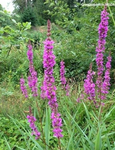
CAPITOL LAKE CAPITOL
                                                                          – DESCHUTES    ESTUARY ESTUARY
                                                                                  LAKE – DESCHUTES
                                                             Long-Term Management Project Environmental Impact Statement
                                                                                   Long-Term Management Project   Environmental Impact Statement

Table of Contents

Executive Summary                                                                                                    1
1.0 Introduction and Project Description                                                                          1-1
            1.1 PROJECT DESCRIPTION                                                                                 1-1

            1.2 SUMMARY OF PROJECT ALTERNATIVES                                                                     1-3

            1.3 CONSTRUCTION METHODS FOR THE ACTION ALTERNATIVES                                                    1-4

2.0 Regulatory Context                                                                                            2-1
            2.1 RESOURCE DESCRIPTION                                                                                2-1

            2.2 FEDERAL AND STATE LAWS, PLANS, AND POLICIES                                                         2-1

            2.3 LOCAL LAWS, PLANS, AND POLICIES                                                                     2-3

3.0 Methodology                                                                                                      1
            3.1 DATA SOURCES AND COLLECTION                                                                            1

            3.2 SELECTION OF THE STUDY AREA                                                                            2

            3.3 ANALYSIS OF IMPACTS                                                                                    2

4.0 Affected Environment                                                                                          4-1
            4.1 AQUATIC INVASIVE PLANTS                                                                             4-1

June 2021                         Aquatic Invasive Species                                                           Page i
                                      Discipline Report
CAPITOL LAKE – DESCHUTES ESTUARY
                                                                      Long-Term Management Project Environmental Impact Statement

             4.2 AQUATIC INVASIVE ANIMALS                                                                            4-17

5.0 Impacts and Mitigation Measures                                                                                 5-1
             5.1 OVERVIEW                                                                                             5-1

             5.2 NO ACTION ALTERNATIVE                                                                                5-1

             5.3 IMPACTS COMMON TO ALL BUILD ALTERNATIVES                                                             5-1

             5.4 MANAGED LAKE ALTERNATIVE                                                                             5-5

             5.5 ESTUARY ALTERNATIVE                                                                                  5-6

             5.6 HYBRID ALTERNATIVE                                                                                  5-11

             5.7 AVOIDANCE, MINIMIZATION, AND MITIGATION MEASURES                                                    5-12

6.0 References                                                                                                      6-1
Exhibits
Tables
Table ES.1 Summary of Construction Impacts and Mitigation Measures                                                          3
Table ES.2 Summary of Operations Impacts (including Benefits) and Mitigation Measures                                       4
Table 2-1.       Aquatic Invasive Species Federal Regulatory Programs and Policies.                                     2-2
Table 2-2.       Aquatic Invasive Species State Regulatory Programs and Policies.                                       2-2
Table 2-3.       Local Laws, Plans, and Policies.                                                                        2-3
Table 4-1.       Aquatic Invasive Plants Observed in the Study Area.                                                    4-2
Table 4-2.       Aquatic Invasive Animals Observed in the Study Area.                                                  4-17

June 2021                                  Aquatic Invasive Species                                                   Page ii
                                              Discipline Report
CAPITOL LAKE – DESCHUTES ESTUARY
                                                                   Long-Term Management Project Environmental Impact Statement

Figures
Figure 1-1   Project Area                                                                                         1-2
Figure 4-1   Purple Loosestrife Distribution in Capitol Lake from 1988 to 2010                                    4-4
Figure 4-2   Purple Loosestrife Distribution in Capitol Lake in 2018                                              4-5
Figure 4-3   Yellow Flag Iris Distribution in Capitol Lake in 2018                                                4-9
Figure 4-4   Fragrant Water Lily Distribution in Capitol Lake in 2018                                             4-12
Figure 4-5   Eurasian Watermilfoil Distribution in Capitol Lake in 2018                                           4-14

June 2021                               Aquatic Invasive Species                                                   Page iii
                                           Discipline Report
CAPITOL LAKE – DESCHUTES ESTUARY
Long-Term Management Project Environmental Impact Statement
List of Acronyms and Abbreviations
Acronyms/
Abbreviations Definition
AIS Aquatic invasive species
EIS Environmental Impact Statement
Enterprise Services Washington State Department of Enterprise Services
GA Washington State Department of General Administration
mm Millimeters
NAM Northwest Aquatics Management, LLC
WDFW Washington Department of Fish and Wildlife
June 2021 Aquatic Invasive Species Page iv
Discipline ReportCAPITOL LAKECAPITOL
– DESCHUTES ESTUARY ESTUARY
LAKE – DESCHUTES
Long-Term Management Project Environmental
Long-Term Impact
Management Project StatementImpact Statement
Environmental
1.0 Introduction and Project Description
1.1 PROJECT DESCRIPTION
The Capitol Lake – Deschutes Estuary includes the 260-acre Capitol Lake Basin, located on the
Washington State Capitol Campus, in Olympia, Washington. The waterbody has long been a valued
community amenity. Capitol Lake was formed in 1951 following construction of a dam and provided an
important recreational resource. Historically, the Deschutes Estuary was used by local tribes for
subsistence and ceremonial purposes. Today, the expansive waterbody is closed to active public use.
There are a number of environmental issues including the presence of invasive species, exceedances of
water quality (WQ) standards, and inadequate sediment management.
The Washington State Department of Enterprise Services (Enterprise Services) is responsible for the
stewardship, preservation, operation, and maintenance of the Capitol Lake Basin. The 260-acre Capitol
Lake Basin is maintained by Enterprise Services under long-term lease agreement from the Washington
Department of Natural Resources.
In 2016, as part of Phase 1 of long-term planning, a diverse group of stakeholders, in collaboration with
the state, identified shared goals for long-term management and agreed an Environmental Impact
Statement (EIS) was needed to evaluate a range of alternatives and identify a preferred alternative. In
2018, the state began the EIS process. The EIS evaluates four alternatives, including a Managed Lake,
Estuary, Hybrid, and a No Action Alternative.
The long-term management alternatives are evaluated against the shared project goals of: improving
water quality; managing sediment accumulation and future deposition; improving ecological functions;
and enhancing community use of the resource. Refer to Figure 1.1 for the project area for long-term
management. The Final EIS will identify a preferred environmentally and economically sustainable
long-term management alternative for the Capitol Lake – Deschutes Estuary.
The EIS process maintains engagement with the existing Work Groups, which include the local
governments, resource agencies, and tribe. It also provides for expanded engagement opportunities for
the public, such as a community sounding board.
June 2021 Aquatic Invasive Species Page 1-1
Discipline ReportCAPITOL LAKE – DESCHUTES ESTUARY
Long-Term Management Project Environmental Impact Statement
Figure 1.1 Project Area
Port of
West Bay Olympia
(Budd Inlet)
Fifth
Avenue Heritage
Dam Park
North Basin
(Reflecting Pool)
Marathon
Park
Capitol
Campus
5
Deschutes
e
tat
Parkway
ers
Int
Middle
Basin
Interpretive
Park
South Basin
Tumwater Deschutes
Falls River
¹
0 625 1,250 2,500
Scale in Feet
June 2021 Aquatic Invasive Species Page 1-2
Discipline ReportCAPITOL LAKE – DESCHUTES ESTUARY
Long-Term Management Project Environmental Impact Statement
1.2 SUMMARY OF PROJECT ALTERNATIVES
1.2.1 Managed Lake Alternative
The Managed Lake Alternative would retain the 5th Avenue Dam in its existing configuration. The 5th
Avenue Dam would be overhauled to significantly extend the serviceable life of the structure. The
reflecting pool within the North Basin would be maintained, and active recreational use would be
restored in this area. Sediment would be managed through initial construction dredging and recurring
maintenance dredging in the North Basin only. Sediment from construction dredging would be used to
create habitat areas in the Middle Basin to support improved ecological function, habitat complexity,
and diversity. Sediment would continue to accumulate and over time would promote a transition to
freshwater wetlands in the South and Middle Basins. Boardwalks, a 5th Avenue Pedestrian Bridge, a
dock, and a boat launch would be constructed for community use.
If selected as the Preferred Alternative, adaptive management plans would be developed to maintain
water quality, improve ecological functions, and manage invasive species during the design and
permitting process.
1.2.2 Estuary Alternative
Under the Estuary Alternative, the 5th Avenue Dam would be removed, and an approximately 500‐foot‐
wide (150‐meter‐wide) opening would be established in its place. This would reintroduce tidal
hydrology to the Capitol Lake Basin, returning the area to estuarine conditions where saltwater from
Budd Inlet would mix with freshwater from the Deschutes River. Sediment would be managed through
initial construction dredging in the Capitol Lake Basin and recurring maintenance dredging within West
Bay. Dredged materials from construction dredging would be used to create habitat areas in the Middle
and North Basins to promote ecological diversity, though tideflats would be the predominant habitat
type. Boardwalks, a 5th Avenue Pedestrian Bridge, a dock, and a boat launch would be constructed for
community use. This alternative also includes stabilization along the entire length of Deschutes
Parkway to avoid undercutting or destabilization from the tidal flow. Existing utilities and other
infrastructure would be upgraded and/or protected from reintroduced tidal hydrology and saltwater
conditions.
If selected as the Preferred Alternative, adaptive management plans would be developed to improve
ecological functions and manage invasive species during the design and permitting process.
1.2.3 Hybrid Alternative
Under the Hybrid Alternative, the 5th Avenue Dam would be removed, and an approximately 500‐foot‐
wide (150‐meter‐wide) opening would be established in its place. Tidal hydrology would be
reintroduced to the western portion of the North Basin and to the Middle and South Basins. Within the
North Basin, a curved and approximately 2,600‐foot‐long (790‐meter‐long) barrier wall with a walkway
would be constructed to create an approximately 45‐acre saltwater reflecting pool adjacent to Heritage
Park. A freshwater (groundwater‐fed) reflecting pool was also evaluated for this EIS. Construction and
June 2021 Aquatic Invasive Species Page 1‐3
Discipline ReportCAPITOL LAKE – DESCHUTES ESTUARY
Long-Term Management Project Environmental Impact Statement
maintenance of this smaller reflecting pool, in addition to restored estuarine conditions in part of the
Capitol Lake Basin, gives this alternative its classification as a hybrid. Sediment would be managed
through initial construction dredging in the Capitol Lake Basin and recurring maintenance dredging
within West Bay. In the Middle and North Basins, constructed habitat areas would promote ecological
diversity, though tideflats would be the predominant habitat type. Boardwalks, a 5th Avenue Pedestrian
Bridge, a dock, and a boat launch would be constructed for community use. This alternative also
includes stabilization along the entire length of Deschutes Parkway to avoid scour or destabilization.
Existing utilities and other infrastructure would be upgraded and/or protected from reintroduced tidal
hydrology and saltwater conditions.
If selected as the Preferred Alternative, adaptive management plans would be developed before
operation of the alternative to improve ecological functions and manage invasive species during the
design and permitting process. Adaptive management would also be needed for a freshwater reflecting
pool, but not for a saltwater reflecting pool.
1.2.4 No Action Alternative
The No Action Alternative represents the most likely future expected in the absence of implementing a
long‐term management project. The No Action Alternative would persist if a Preferred Alternative is
not identified and/or if funding is not acquired to implement the Preferred Alternative. A No Action
Alternative is a required element in a SEPA EIS and provides a baseline against which the impacts of the
action alternatives (Managed Lake, Estuary, Hybrid) can be evaluated and compared.
The No Action Alternative would retain the 5th Avenue Dam in its current configuration, with limited
repair and maintenance activities, consistent with the scope and scale of those that have received
funding and environmental approvals over the past 30 years. In the last 30 years, the repair and
maintenance activities have been limited to emergency or high‐priority actions, which occur
sporadically as a result of need and funding appropriations.
Although Enterprise Services would not implement a long‐term management project, current
management activities and ongoing projects in the Capitol Lake Basin would continue. Enterprise
Services would continue to implement limited nuisance and invasive species management strategies.
In the absence of a long‐term management project, it is unlikely that Enterprise Services would be able
to procure funding and approvals to manage sediment, improve water quality, improve ecological
functions, or enhance community use. The No Action Alternative does not achieve the project goals.
1.3 CONSTRUCTION METHODS FOR THE ACTION ALTERNATIVES
This impact analysis relies upon the construction method and anticipated duration for the action
alternatives, which are described in detail in Chapter 2 of the EIS.
June 2021 Aquatic Invasive Species Page 1‐4
Discipline ReportCAPITOL LAKECAPITOL
– DESCHUTES ESTUARY ESTUARY
LAKE – DESCHUTES
Long-Term Management Project Environmental
Long-Term Impact
Management Project StatementImpact Statement
Environmental
2.0 Regulatory Context
2.1 RESOURCE DESCRIPTION
This report describes aquatic invasive plant and animal species in the study area and evaluates the
potential impact of each project alternative on invasive species populations and their spread outside
the study area. Invasive species are nonnative organisms that cause economic or environmental harm
and can spread to new areas of the state (RCW 79A.25.310). Aquatic invasive species (AIS) are invasive
species that rely on the aquatic environment for all or a portion of their life cycle. Nonnative, non-
indigenous, or exotic species are those species that are present outside of their natural range. Unlike
invasive species, nonnative species do not necessarily hinder or prevent the survival of native species
within the ecosystem. Nuisance species may be native or nonnative and may cause ecological and
economic harm.
2.2 FEDERAL AND STATE LAWS, PLANS, AND POLICIES
Several federal, state, and local government policies, regulations, and ordinances relating to the
eradication and management of invasive species apply to this project. Such regulations and policies
influence planning, land use, and management activities that can impact fish and wildlife species and
their habitats within the study area. Tables 2-1 and 2-2 summarize federal and state regulations and
programs for AIS eradication and management. While several federal laws may address AIS, such as the
Clean Water Act, Coastal Management Zone, Fish and Wildlife Conservation Act, and the Magnuson-
Stevens Fishery Conservation and Management Act, the primary purpose of these regulations is not
invasive species management. For more information on these regulations, see the Fish and Wildlife
Discipline Report and the Wetlands and Vegetation Discipline Report.
June 2021 Aquatic Invasive Species Page 2-1
Discipline ReportCAPITOL LAKE – DESCHUTES ESTUARY
Long-Term Management Project Environmental Impact Statement
Table 2-1. Aquatic Invasive Species Federal Regulatory Programs and Policies.
Regulatory Program
or Policies Lead Agency Description
Aquatic Nuisance U.S. Fish and U.S. Fish and Wildlife Service coordinates with federal
Species Task Force Wildlife Service agencies and partners to prevent and control AIS and
provide expertise and support for action-oriented
partnerships (84 FR 56832; October 23, 2019).
Executive Order 13112 – National Invasive This executive order prevents federal agencies from
Invasive Species Species Council authorizing, funding, or carrying out actions that are likely to
cause or promote the introduction or spread of invasive
species (USDA 1999).
Federal Insecticide, U.S. Environmental This Act requires the study of the consequences of pesticide
Fungicide, and Protection Agency usage and requires users to register when purchasing
Rodenticide Act pesticides. All pesticides must be registered (licensed) by
USEPA. Registration ensures that pesticides will be properly
labeled and used in accordance with specifications that will
not cause unreasonable harm to the environment
(7 USC §136 et seq. 1996).
National Invasive U.S. Department of An Act to prevent and control infestations of the coastal
Species Act Agriculture inland waters of the United States by the zebra mussel and
other nonindigenous aquatic nuisance species (H.R. 4283;
104th Congress 1996).
Executive Order 13751 – National Invasive An Act that directs actions to coordinate federal prevention
Safeguarding the Species Council and control efforts related to invasive species (USDA 2016).
Nation from the
Impacts of Invasive
Species
Table 2-2. Aquatic Invasive Species State Regulatory Programs and Policies.
Regulatory
Program
or Policies Lead Agency Description
Invasive Species Policy Washington The council is tasked with providing policy level direction,
Coordination Invasive Species planning, and coordination to the various public and private
Council entities working throughout Washington State in order to
prevent and control the spread of harmful invasive species.
Aquatic Invasive Washington Operators of watercraft not registered in Washington State,
Species Prevention Department of seaplanes, and commercial transporters of specified vessel
Fish and Wildlife types must purchase AIS prevention permits to help prevent
the spread of aquatic invasive species in Washington (WDFW
2020a).
Invasive Species Law Washington RCW 77.15.805 enforces the Invasive Species Law.
Department of RCW 77.135 prohibits transporting any visible native and
Fish and Wildlife nonnative aquatic animals, plants, or other organisms, as well
as raw water on any boat, trailer, fishing gear, or bait well.
June 2021 Aquatic Invasive Species Page 2-2
Discipline ReportCAPITOL LAKE – DESCHUTES ESTUARY
Long-Term Management Project Environmental Impact Statement
Regulatory
Program
or Policies Lead Agency Description
Washington State Washington State RCW 17.10 provides for the creations of the state noxious weed
Noxious Weed Law Noxious Weed board, county noxious weed boards, the state noxious weed
Control Board list, landowner responsibilities in noxious weed control, and
the ability of employees of the state weed board, county weed
boards, or Washington State Department of Agriculture to
carry out their duties and authorities assigned under this
chapter.
2.3 LOCAL LAWS, PLANS, AND POLICIES
Table 2-3 describes the regulatory programs implemented by the study area communities.
Table 2-3. Local Laws, Plans, and Policies.
Regulatory
Program
or Policies Lead Agency Description
Critical Area Olympia Municipal This Code creates regulations regarding the presence of
Development Code invasive species in critical areas, riparian buffers, and
Regulations mitigation/restoration sites (OMC 18.32).
Fish and Wildlife Tumwater This Code creates regulations regarding the removal of
Habitat Conservation Municipal Code noxious weeds and invasive plants and addresses introduction
Areas of invasive and nonnative plant species (TMC 16.32).
Noxious Weed Control Thurston County The Thurston County Noxious Weed Control Board fulfills the
Noxious Weed requirements of RCW 17.10 and establishes policies and
Control Board procedures in accordance with statutes and state regulations,
adopts rules and regulations for noxious weed control, and
prepares the annual Noxious Weed List (Thurston County
2020a).
June 2021 Aquatic Invasive Species Page 2-3
Discipline ReportCAPITOL LAKECAPITOL
– DESCHUTES ESTUARY ESTUARY
LAKE – DESCHUTES
Long-Term Management Project Environmental
Long-Term Impact
Management Project StatementImpact Statement
Environmental
3.0 Methodology
3.1 DATA SOURCES AND COLLECTION
An extensive literature review was conducted for this report. Over 75 data sources were reviewed for
the AIS evaluation, including management plans, surveys, databases, and research papers.
3.1.1 Management Plans
The management plans reviewed include vegetation management, reports on permit needs, annual
reports of aquatic weed treatments, New Zealand mudsnail management options, and
recommendations for future and ongoing invasive species treatments. The primary management plans
used in the evaluation that provided recent and relevant information include:
● Deschutes River Estuary Restoration Study: Biological Conditions Report (Garono et al.
2006)
● Capitol Lake New Zealand Mudsnail Management Options (WDFW 2016a)
● Capitol Lake Weed Management Services 2018 Annual Report (NAM 2018)
3.1.2 Surveys
Several surveys have been conducted to monitor the presence and distribution of AIS in Capitol Lake,
and some surveys were associated with AIS treatment and removal efforts. The primary surveys used in
this evaluation that provided recent and relevant information include:
● Capitol Lake Vertebrate and Invertebrate Inventory (Herrera 2004)
● Capitol Lake Weed Management Services, Bottom Screen Report (NAM 2011)
● 2012 Milfoil Weevil Population Survey in Capitol Lake and East Mitigation Pond
(EnviroScience 2013)
● 2015 Survey for Potamopyrgus antipodarum (New Zealand Mudsnail) Within a Five-Mile
Radius of Capitol Lake (Johannes 2015)
June 2021 Aquatic Invasive Species Page 3-1
Discipline ReportCAPITOL LAKE – DESCHUTES ESTUARY
Long-Term Management Project Environmental Impact Statement
3.1.3 Databases
To maintain the most recent evidence of invasive species presence and spread in the area, several
databases were reviewed. The main databases used in this evaluation that provided recent and relevant
information include:
● Federal Noxious Weeds (USDA 2020)
● Noxious Weed layer on the Show Me Everything map (Thurston County 2020b)
● Nonindigenous Aquatic Species (USGS 2020)
● Aquatic Invasive Species (WDFW 2020b)
● Washington Marine Vegetation Atlas (WDNR 2020)
3.1.4 Research Papers
Research papers and studies used in this evaluation explored a diverse range of topics including
detection, species biology (specifically as it relates to the overall success of an AIS in a nonnative area),
population fluctuations, transport and spread, and treatment options and effectiveness. Some
examples of research papers used in this evaluation include:
● A review of salinity tolerances for the New Zealand mudsnail (Potamopyrgus antipodarum,
Gray 1843) and the effect of a controlled saltwater backflush on their survival in an
impounded freshwater lake (LeCLair and Cheng 2011)
● Environmental DNA as a new method for early detection of New Zealand mudsnails
(Goldberg et al. 2013) A quantitative evaluation of the effect of freezing temperatures on
the survival of New Zealand mudsnails (Potamopyrgus antipodarum; Gray 1843), in Olympia
Washington’s Capitol Lake (Cheng and LeClair 2011)
● Survival and passage of ingested New Zealand mudsnails through the intestinal tract of
rainbow trout (Bruce et al. 2009)
3.2 SELECTION OF THE STUDY AREA
The study area is based on the local aquatic resources where AIS could be directly affected by the
project, and does not include distant water bodies where AIS potentially could be transported to by the
project. The study area includes the Capitol Lake Basin (the North Basin, Middle Basin, South Basin,
and Percival Cove), Percival Creek up to Highway 101, the Deschutes River upstream of Tumwater Falls,
and Lower Budd Inlet extending north from the 5th Avenue Dam to southern end of Priest Point Park
near the mouth of Mission Creek (47 07′N) (Figure 1.1). The study area extends approximately 100 feet
from the edge of these waters to encompass emergent plant, amphibian, waterfowl, and mammal AIS.
3.3 ANALYSIS OF IMPACTS
Adverse impacts and beneficial effects related to both construction and long-term operation are
evaluated, with a focus on comparatively evaluating the alternatives. In general, construction-related
June 2021 Aquatic Invasive Species Page 3-2
Discipline ReportCAPITOL LAKE – DESCHUTES ESTUARY
Long-Term Management Project Environmental Impact Statement
impacts are primarily associated with lake sediment dredging and dam construction (repair or removal)
because that activity represents the major construction impact. Future, long-term adverse impacts, and
beneficial effects associated with AIS populations and control actions for each of the four project
alternatives are evaluated using a combination of historical trends, current conditions, and future
projections of environmental factors affecting AIS.
Assessments of potential adverse impacts and beneficial effects are based on many factors including:
● Anticipated changes in abundance and distribution for each species
● Relative potential for transport and establishment within and outside the study area
● Control priority, eradication potential and potential management options of each species
● Relative effectiveness and non-target species impacts of control measures
● Potential for short- and long-term recreational use restrictions
Qualitative categories such as “less-than-significant” and “significant” are used to assess the relative
magnitude of adverse impacts related to AIS. Significant increases in AIS populations or distribution by
an alternative are considered to be an adverse impact, whereas significant decreases in AIS populations
or distribution are considered a beneficial effect of the alternative.
3.3.1 Identification of Construction Impacts
Sediment dredging, dredged material placement for constructing habitat areas, and dam construction
(repair or removal) are the primary construction activities affecting AIS. These activities have the
potential adverse impact of spreading existing AIS in Capitol Lake to other water bodies if the following
occur:
● AIS associated with suspended sediment and debris care are not contained.
● Construction equipment is not properly decontaminated before it leaves the lake.
● Dredged material is not properly decontaminated before it leaves the lake.
● Equipment is not properly decontaminated before use in the lake, leading to the
introduction of new AIS.
Dredging and dredge material placement has the potential beneficial effect of reducing existing AIS
populations through burial.
Repairs to the existing 5th Avenue Dam have the potential adverse impact of spreading existing AIS in
Capitol Lake to Budd Inlet and adjacent streams if the construction area is not properly contained.
Other construction activities potentially affecting AIS by improper equipment decontamination include
construction of the boardwalks and docks, and the pedestrian and bicycle bridge.
June 2021 Aquatic Invasive Species Page 3-3
Discipline ReportCAPITOL LAKE – DESCHUTES ESTUARY
Long-Term Management Project Environmental Impact Statement
For this evaluation, the magnitude of short-term adverse impacts is considered less-than-significant or
significant, as follows:
● Less-than-significant―Impacts are considered less-than-significant if there would be no
substantial increased risk, relative to existing conditions, of introducing new AIS to a water
body during construction that would impact native species or recreational use. Any
potential short-term effect of construction on the abundance of existing AIS within a water
body is considered less-than-significant because AIS are inherently resilient to disturbance
and expected to recover from short-term changes in abundance.
● Significant―Impacts are considered significant if there would be a substantial increased
risk, relative to existing conditions, of introducing new AIS to a water body during
construction that would impact native species or recreational use.
The adverse impacts and beneficial effects of construction on each AIS are described for each
alternative in Section 5.0 Impacts and Mitigation Measures.
3.3.2 Identification of Operational Impacts
Changes in the salinity and recreational use of the Capitol Lake Basin are the primary operational
impacts to AIS that could be positive or negative. That is, increased salinity has the beneficial effect of
reducing survivorship of freshwater AIS, and increased recreational use has the potential adverse
impact of increasing the potential for further spread of AIS. Maintenance dredging also has the
potential for introducing new AIS if equipment is not properly decontaminated or spreading AIS from
offsite transport of dredged sediments.
For this evaluation, the magnitude of long-term (operational) adverse impacts are considered less-
than-significant or significant, as follows:
● Less-than-significant―Impacts are considered less-than-significant if no substantial
increase (e.g., less than a 50 percent increase) is expected for the abundance or distribution
of existing AIS within the study area, or if the potential for existing AIS to spread to other
water bodies is expected to not substantially increase and impact native populations or
recreational use, relative to the existing condition.
● Significant―Impacts are considered significant if a substantial increase (e.g., more than 50
percent increase) is expected for the abundance or distribution of existing AIS within the
study area, or if the risk of introducing new AIS would substantially increase for waters
inside or outside the study area and impact native populations or recreational use, relative
to the existing condition.
Long-term beneficial effects on AIS are evaluated in terms of minor, moderate, or substantial beneficial
effects where expected decreases in AIS abundance or distribution inside or outside the study area are
considered beneficial. The impact of regular operations on each AIS is described for each alternative in
Section 5.0 Impacts and Mitigation Measures.
June 2021 Aquatic Invasive Species Page 3-4
Discipline ReportCAPITOL LAKECAPITOL
– DESCHUTES ESTUARY ESTUARY
LAKE – DESCHUTES
Long-Term Management Project Environmental
Long-Term Impact
Management Project StatementImpact Statement
Environmental
4.0 Affected Environment
Capitol Lake has a well-documented presence of AIS including plants, invertebrates, fish, waterfowl,
and aquatic mammal species. The presence of AIS has resulted in closure of Capitol Lake to all public
use. This section briefly describes the species biology, documented presence in Capitol Lake, the
ecological impact of the AIS presence, and previous efforts to control the presence and spread of
invasive species.
The biology of an invasive species provides information on its ability to outcompete native species for
resources. Before an invasive species can become a nuisance in an ecosystem after being introduced, it
must survive, grow, and reproduce in the new environmental conditions. Thus, an invasive species must
acquire a high rate of population growth, invading new regions before it finally alters the structure and
function of the invaded ecosystem (Alonso and Castro-Díez 2008). The existing presence and spread of
AIS provide data on the pathway and possible containment. Biological invasions often represent a
major ecological and economic problem. The description of ecological impacts will inform the potential
impacts or benefits for each alternative. Previous efforts to control AIS presence and spread, both in
Capitol Lake and outside the study area, inform future decisions for control efforts that differ based on
each alternative explored in later sections.
4.1 AQUATIC INVASIVE PLANTS
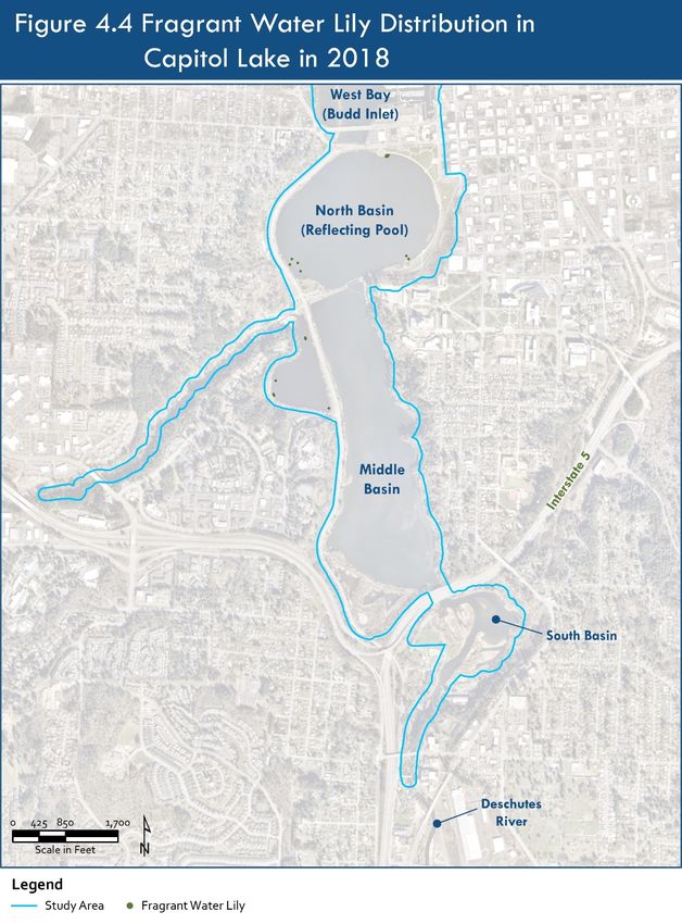
Aquatic invasive plants found in Capitol Lake and the surrounding water bodies include purple
loosestrife (Lythrum salicaria), yellow flag iris (Iris pseudacorus), reed canarygrass (Phalaris arundinacea),
fragrant water lily (Nymphaea odorata), Eurasian watermilfoil (Myriophyllum spicatum), and curlyleaf
pondweed (Potamogeton crispus). Table 4-1 describes their classification on the Washington State
Noxious Weed List (2020), distribution in the study area, and relative abundance in study area.
June 2021 Aquatic Invasive Species Page 4-1
Discipline ReportCAPITOL LAKE – DESCHUTES ESTUARY
Long-Term Management Project Environmental Impact Statement
Table 4-1. Aquatic Invasive Plants Observed in the Study Area.
Scientific/ State
Common Name Statusa Water Body Relative Abundance Source
Emergent
Lythrum salicaria Class B Capitol Lake, High in the South Basin and Percival NAM
Purple loosestrife High Deschutes Cove; low in other basins 2018
Priority River, Budd Inlet
Iris pseudacorus Class C Capitol Lake High in the South and Middle Basins; NAM
Yellow flag iris Moderate in Percival Cove; low in the 2018
North Basin.
Phalaris arundinacea Class C Capitol Lake Present at unknown locations in 2006 Ecology
Reed canary grass 2020a
Floating Leaved
Nymphaea odorata Class C Capitol Lake Moderate in North Basin and Percival NAM
Fragrant waterlily Cove; low to zero in Middle Basin and 2018
South Basin
Submersed
Myriophyllum spicatum Class B Capitol Lake Moderate in South Basin, Middle NAM
Eurasian watermilfoil High Basin, and Percival Cove; low in North 2018
Priority Basin
Potamogeton crispus Class C Capitol Lake Present at unknown locations in 2006 Ecology
Curlyleaf pondweed and primarily in the south end of lake 2020a
in 2004
a
Washington State Noxious Weed Class (WNWCB 2020) or High Priority Invasive Species (WISC 2020c).
Class A noxious weeds are nonnative species whose distribution in Washington is still limited.
Eradication of Class A noxious weeds is required by law. Class B noxious weeds are nonnative species
whose distribution are limited to portions of Washington. Control of Class B noxious weeds is required
in regions where they are not yet widespread in order to prevent new infestations. Class C noxious
weeds are widespread in Washington or are of special interest to the agricultural industry (WNWCB
2020).
4.1.1 Presence in Capitol Lake
The biology, ecological and recreational implications, distribution, and abundance of aquatic invasive
emergent, floating-leaved, and submerged plants in Capitol Lake are described in the following
sections. Distribution, abundance, and management efforts are described in approximate chronological
order for each plant species.
June 2021 Aquatic Invasive Species Page 4-2
Discipline ReportCAPITOL LAKE – DESCHUTES ESTUARY
Long-Term Management Project Environmental Impact Statement
4.1.1.1 Emergent Plants
Purple Loosestrife
Purple loosestrife (Lythrum salicaria) is a Class B Washington State Listed Noxious Weed (Washington
State Noxious Weed Control Board 2020) and a High Priority invasive species (WISC 2020c). Control of
Class B species is required by the Thurston County Noxious Weed
Board. The plant is a nonnative emergent species typically found in
freshwater and brackish wetlands, along streams, and in other wet
areas. It has narrow, lance-shaped leaves; showy purple flowers
that occur in erect spikes at the top of stems from late June
through October; and a rhizomatous growth pattern. The plant is a
vigorous grower that spreads by rhizomes or by seed. Each plant
may produce up to 2.7 million seeds annually. The seeds can be
viable for several years, but because the seeds are small and carry
little food reserves, germination must occur when photosynthesis
can occur immediately (USDA 2020). Purple loosestrife forms
dense colonies that outcompete native plant species and provide
minimal wildlife habitat (Ecology 2001). These dense colonies can Purple Loosestrife (WNWCB 2020)
also be detrimental to aesthetics and inhibit access to shorelines
for recreation (RMI 2001). Management of purple loosestrife is a costly effort requiring repeated
monitoring and removal efforts to prevent its spread.
Distribution and Abundance Within the Study Area
Purple loosestrife was first discovered in Capitol Lake in 1986. By 1987, the infestation was described as
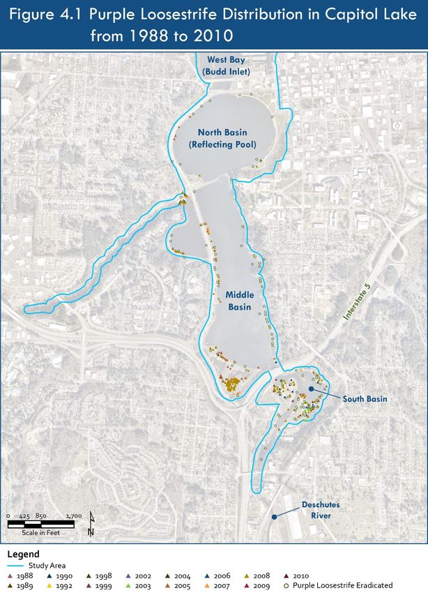
“bad” (Washington State Department of General Administration [GA] 2002). Figure 4-1 presents a map
of purple loosestrife historical observations from 1988 through 2010 along with observation points
colored red where it had been eradicated. Figure 4-2 presents the most current map of purple
loosestrife distribution in 2018 with observation points colored purple (NAM 2018). Purple loosestrife
was most abundant in the South Basin but was present along the shorelines of all three basins, the
mitigation area, and Percival Cove. Only one plant was observed in the North Basin, and no plants were
observed along the east shoreline of the Middle Basin. Although purple loosestrife is a high-priority
species based on its aggressive growth and potential impacts on native species, it is not likely
significantly impacting native wildlife or recreation in the Capitol Lake Basin based on its current
abundance and the emergent plant diversity.
June 2021 Aquatic Invasive Species Page 4-3
Discipline ReportCAPITOL LAKE – DESCHUTES ESTUARY
Long-Term Management Project Environmental Impact Statement
June 2021 Aquatic Invasive Species Page 4-4
Discipline ReportCAPITOL LAKE – DESCHUTES ESTUARY
Long-Term Management Project Environmental Impact Statement
June 2021 Aquatic Invasive Species Page 4-5
Discipline ReportCAPITOL LAKE – DESCHUTES ESTUARY
Long-Term Management Project Environmental Impact Statement
Management Approaches
In 1987, the Thurston County Noxious Weed Control Board and the GA began communicating to
organize efforts to control purple loosestrife. From 1989 to 1993, various maintenance groups and
contracted groups for the GA removed flower heads to prevent seed distribution. From 1993 to 1995,
the GA contracted with Resource Management, Inc. to perform aquatic herbicide treatments on purple
loosestrife in Capitol Lake, but information on the relative effectiveness of the treatments was not
available.
From 1996 to 2000, the GA returned to removing flower heads to control purple loosestrife because the
herbicide treatments did not eradicate purple loosestrife. Based on the results of these efforts, it was
determined that seed production is controlled by flower head removal, but stem densities still increase
in the case of flower head removal. It was determined that future efforts should include treatment of
the entire plant along with seed removal. The lack of continuity in treatments from year to year and the
lack of monitoring after control efforts were implemented limits the understanding of the efficacy of
management actions.
In 1998, wetland soils from the southern end of the Middle Basin were removed and replaced as a
mitigation measure for Heritage Park, subsequently soils bordering the constructed wetland mitigation
ponds in Interpretive Park were quickly infested with purple loosestrife. In 1999, the Thurston County
Noxious Weed Board released 5,000 galerucella beetles (Galerucella calmariensis) as a form of biological
control for loosestrife populations in the Interpretive Park wetland ponds. Later reports indicate that
purple loosestrife showed signs of beetle activity; however, the population of beetles was not dense
enough to control the purple loosestrife infestation in this area (NAM 2013, 2017).
In 2000, the infestation of purple loosestrife was determined to have been reduced by 80 percent from
levels in 1987 (NAM 2013). In 2001, the GA adopted the Capitol Lake Integrated Purple Loosestrife
Management Plan, which established the goal to eradicate purple loosestrife from Capitol Lake and
adjacent areas (RMI 2001). This plan describes results from a field survey done by aquatic biologists in
December of 2000 and input from GA Grounds Supervisor Mark Robb. According to these sources,
approximately 2.5 acres of dense purple loosestrife colonies were present in the wetland mitigation
area at the south end of the Middle Basin. Approximately 1.3 acres of moderate-density purple
loosestrife were also present in this area. Approximately 1.9 acres of low-density loosestrife were
present in the mitigation area and along the western shorelines of the Middle Basin. In December 2000,
the total area of purple loosestrife infestation was approximately 5.7 acres along 1.4 miles of shoreline
in Capitol Lake. The established seed bank was estimated to be sufficient to support regrowth for a
minimum of 10 years.
The 2001 Capitol Lake Integrated Purple Loosestrife Management Plan recommended a combination
of surveillance, public education, chemical control with glyphosate spot-treatment, biological controls
(insect introductions), and manual removal to eradicate the plant from Capitol Lake. This plan stressed
the importance of consistency, monitoring, and data collection in effectively eradicating purple
loosestrife.
June 2021 Aquatic Invasive Species Page 4-6
Discipline ReportCAPITOL LAKE – DESCHUTES ESTUARY
Long-Term Management Project Environmental Impact Statement
From 2008 to 2015, purple loosestrife was treated with a 3 percent solution of glyphosate and plant
mortality was observed within one week of application. From 2016 to 2018, a 15 percent solution of
Imazapyr replaced the glyphosate treatments, and seed head removal continued. Plant mortality from
imazapyr treatments was observed within one to two weeks of application (NAM 2017). Management
activities in 2019 were not conducted due to an oil spill preventing lake access. In 2019, continued use of
surveys, seed head removal, and imazapyr treatments was recommended for future years (NAM 2020).
Survey results and observations from the management efforts are described in the following
paragraphs.
From 2009 through 2012, purple loosestrife was densely populated in the South Basin and in the
mitigation areas at the south end of the Middle Basin (NAM 2013). It reduced from moderately
populated in 2009 to sparsely populated from 2010 through 2012 on the western side of the Middle
Basin and in Percival Cove, and only up to two plants were observed in the North Basin.
In 2013, reduced densities were observed in the South Basin and the Middle Basin mitigation area.
Surveys in 2013 indicated the lowest recorded populations of purple loosestrife, indicating the positive
impacts of management strategies (NAM 2014). However, purple loosestrife populations increased
slightly in 2014 to low densities in the South and Middle Basins, moderate densities in Percival Cove and
in the mitigation areas at the southern end of the Middle Basin, and none in the North Basin (NAM
2016).
The 2015 surveys indicated a continued increase in purple loosestrife populations to high densities in
the South Basin and Percival Cove, moderate in the mitigation area at the south end of the Middle
Basin, and low in the Middle and North Basins (NAM 2016). These density ratings did not change in
2016, 2017, or 2018 (NAM 2017, 2018). No assessment or survey was completed in 2019 due to an oil
spill that prohibited access to the lake (NAM 2020).
Yellow Flag Iris
Yellow flag iris (Iris pseudacorus) is a Class C Washington State
Listed Noxious Weed (Washington State Noxious Weed Control
Board 2020) that grows along shorelines in shallow water in
wetlands, and at the edges of lakes or slow-moving rivers. The
plant is perennial, grows 2 to 3 feet tall, and produces pale to
dark yellow flowers with brownish purple mottled markings.
Yellow flag iris spreads by rhizomes and by seed to form large
clumps that outcompete native vegetation, reducing habitat
complexity for wildlife. Rhizome fragments may re-root and form Yellow Flag Iris (WNWCB 2020)
new plants, enabling the plant to further spread. The plant is toxic to livestock, not palatable to most
wildlife, and its resin may irritate human skin. Dense clumps of yellow flag iris may inhibit access to
shorelines for recreation. Management of yellow flag iris is costly, requiring repeated monitoring and
removal efforts to prevent its spread.
June 2021 Aquatic Invasive Species Page 4-7
Discipline ReportCAPITOL LAKE – DESCHUTES ESTUARY
Long-Term Management Project Environmental Impact Statement
Distribution and Abundance Within the Study Area
Yellow flag iris is known to have dominated wetland plant communities in Capitol Lake in 1992 and very
likely existed in the area prior to this date (GA 1992). Survey results and observations from the
management efforts are described in the following paragraphs.
In 2008, survey records indicate approximately 500 yellow flag iris plant clusters on Enterprise Services
property in Capitol Lake. Yellow flag iris was densely populated in the South and Middle Basin and in
Percival Cove, and moderately populated in the North Basin (NAM 2013). A total of 3,015 square feet of
dense yellow flag iris colonies in Heritage Park, Percival Cove, and the Interpretive Park wetland ponds
at the south end of the Middle Basin were treated in 2008 with glyphosate.
The number of yellow flag iris plant clusters significantly reduced to 250 in 2009 and to 200 in 2010;
however, yellow flag iris remained densely populated in the South Basin and Percival Cove. The
population on the eastern shoreline of the Middle Basin was significantly reduced in comparison to
2008. The density of yellow flag iris in the Middle Basin overall and in the North Basin in 2009 was
moderate (NAM 2013).
In 2011, the survey team transitioned from tracking groups of plants in previous years to tracking
individual plants. Approximately 450 yellow flag iris plants were observed in 2011, increasing the
density in the South, Middle, and North Basin and in Percival Cove. However, plants were generally
smaller and immature compared to those observed in 2008 and 2009, indicating some success in the
glyphosate treatments despite the remaining presence of dense populations (NAM 2013).
In 2012 and 2013, approximately 100 yellow flag iris plants were observed at a moderate density in the
South Basin, Percival Cove, and in the North Basin, and a high density in the Middle Basin. The decrease
in the number of plants from 2011 to 2012 suggest the success of herbicide and manual control efforts
(NAM 2013). However, the number of observed plants doubled to 200 in 2014 along with an increase to
high density in the South Basin and Percival Cove (NAM 2014). The increase in yellow flag iris in 2014
may have resulted from higher water levels during the growing season, providing favorable conditions
for the growth of the plant (NAM 2014).
The number of yellow flag iris plants observed on Enterprise Services property was relatively consistent
at 135 plants in 2015, 142 plants in 2016,148 plants in 2017, and 125 plants in 2018 (NAM 2016, 2017,
2018). Overall, yellow flag iris was densely populated in the South and Middle Basins, particularly on the
eastern shoreline of the Middle Basin, while the population density was moderate in Percival Cove and
low in the North Basin. It was concluded that yellow flag iris populations could be further reduced if
plants on private properties were either treated with imazapyr or manually removed.
Figure 4-3 presents the most current map of yellow flag iris distribution in 2018 with observation points
colored light green (NAM 2018). As described above, yellow flag iris was documented as most abundant
along the east shoreline of the Middle Basin, but was present in all three lake basins, the Interpretive
Park wetlands, and Percival Cove. Yellow flag iris is not likely significantly impacting native wildlife or
recreation in the Capitol Lake Basin based on its current abundance and the emergent plant habitat
diversity.
June 2021 Aquatic Invasive Species Page 4-8
Discipline ReportCAPITOL LAKE – DESCHUTES ESTUARY
Long-Term Management Project Environmental Impact Statement
June 2021 Aquatic Invasive Species Page 4-9
Discipline ReportCAPITOL LAKE – DESCHUTES ESTUARY
Long-Term Management Project Environmental Impact Statement
Management Approaches
From 2008 to 2015, yellow flag iris was surveyed annually and treated with a 3 percent solution of the
aquatic herbicide glyphosate. Plant die-off was observed 1 to 2 weeks after application (NAM 2013). In
2016, treatment was transitioned to a 1.5 percent solution of imazapyr (NAM 2016). Plant die-off was
observed 1 to 2 weeks after application. The imazapyr chemical treatment continued in 2017 and 2018
(NAM 2018). During each year of management, yellow flag iris was treated and counted on all
Enterprise Services property adjacent to the shoreline of Capitol Lake. Seeds were removed from plants
on residential properties adjacent to the shoreline of Capitol Lake, but these plants were not included in
survey numbers.
Reed Canarygrass
Reed canarygrass (Phalaris arundinacea) is a Class C Washington
State Listed Noxious Weed (Washington State Noxious Weed
Control Board 2020) that grows along the margins of lakes and
streams and in wetlands in wet open areas. The plant is a tall,
coarse, perennial grass (Ecology 2001). Stems may grow to be 2
meters tall with leaves that are blue-green when new and straw-
colored when dry, and pinkish flowers at full bloom. Reed
canarygrass spreads by rhizomes and by seed to form dense
monoculture colonies that outcompete native vegetation, reduce Reed Canarygrass (WNWCB 2020)
habitat complexity for wildlife, and inhibit recreational activities along shorelines. It grows too densely
to be used by waterfowl for cover and is not eaten by many wildlife species. It may provide amphibian
habitat. It also slows and filters surface water during storm events, thus providing important hydrologic
and water quality functions.
Distribution and Abundance Within the Study Area
Reed canarygrass is known to have dominated wetland plant communities in Capitol Lake in 1992 and
very likely existed prior to this date (GA 1992). It was observed in Capitol Lake in 2004 as dominant in
nearly monospecific (one species only) patches, but a map of its distribution is not available (Ecology
2020a). Reed canarygrass is not likely significantly impacting native wildlife based on the current
emergent plant diversity in in the Capitol Lake Basin.
Management Approaches
Reed canarygrass has not been the focus of any documented large-scale management or monitoring
efforts reviewed for this study. As a result, detailed descriptions of its presence in Capitol Lake are
unavailable; however, it is very likely present in wetlands adjacent to all basins due to the lack of control
efforts.
June 2021 Aquatic Invasive Species Page 4-10
Discipline ReportYou can also read