Hunter Wetlands National Park - NSW NATIONAL PARKS & WILDLIFE SERVICE Plan of Management
←
→
Page content transcription
If your browser does not render page correctly, please read the page content below
NSW NATIONAL PARKS & WILDLIFE SERVICE

Hunter Wetlands
National Park
Plan of Management

environment.nsw.gov.au
© 2020 State of NSW and Department of Planning, Industry and Environment
With the exception of photographs, the State of NSW and Department of Planning, Industry and
Environment are pleased to allow this material to be reproduced in whole or in part for educational
and non-commercial use, provided the meaning is unchanged and its source, publisher and
authorship are acknowledged. Specific permission is required for the reproduction of photographs.
The Department of Planning, Industry and Environment (DPIE) has compiled this report in good faith,
exercising all due care and attention. No representation is made about the accuracy, completeness or
suitability of the information in this publication for any particular purpose. DPIE shall not be liable for
any damage which may occur to any person or organisation taking action or not on the basis of this
publication. Readers should seek appropriate advice when applying the information to their specific
needs.
All content in this publication is owned by DPIE and is protected by Crown Copyright, unless credited
otherwise. It is licensed under the Creative Commons Attribution 4.0 International (CC BY 4.0),
subject to the exemptions contained in the licence. The legal code for the licence is available at
Creative Commons.
DPIE asserts the right to be attributed as author of the original material in the following manner: ©
State of New South Wales and Department of Planning, Industry and Environment 2020.
Cover photo: Hunter Wetlands National Park. D Benson/DPIE
This plan of management was adopted by the Minister for Energy and Environment on 23
March 2020.
Hunter Wetlands National Park is in the traditional Countries of the Awabakal and Worimi peoples.
This plan of management was prepared by staff of the NSW National Parks and Wildlife Service
(NPWS), part of DPIE.
Valuable information and comments were provided by members of a Stakeholder Working Group,
including Daryl Bower (Central Coast Hunter Regional Advisory Committee), Chris Herbert and Ann
Lindsey (Hunter Bird Observers Club), David Horkan (community representative), Arthur Beckmore
(recreational fishers), Colin Rae (NSW Ports Authority), Peggy Svoboda (Hunter Local Land
Services), Kylie Russell (Department of Primary Industries – Fisheries NSW), Kristy Munro (the City of
Newcastle Council representative), Brian Purdue (Green Corridor Coalition), and Neville and Lorraine
Lilley (Worimi Elders).
For additional information or any inquiries about this park or this plan of management, contact the
NPWS Lower Hunter Area Office at Hunter Wetland Centre, Sandgate Road, Shortland NSW or by
phone on 02 4946 4100.

Published by:
Environment, Energy and Science
Department of Planning, Industry and Environment
4 Parramatta Square, 12 Darcy Street, Parramatta NSW 2150
Phone: +61 2 9995 5000 (switchboard)
Phone: 1300 361 967 (Environment, Energy and Science enquiries)
TTY users: phone 133 677, then ask for 1300 361 967
Speak and listen users: phone 1300 555 727, then ask for 1300 361 967
Email: info@environment.nsw.gov.au
Website: www.environment.nsw.gov.au
Report pollution and environmental incidents
Environment Line: 131 555 (NSW only) or info@environment.nsw.gov.au
See also www.environment.nsw.gov.au
ISBN 978-1-922318-76-3
EES 2020/0152
April 2020

Find out more about your environment at:

www.environment.nsw.gov.au
Contents
Vision Statement                                       v
1. Introduction                                        1
     1.1 Location, reservation and regional setting    1
     1.2 What is special about the park                2
2.   Management context                               4
     2.1   Legislative and policy framework            4
     2.2   Management purposes and principles          4
     2.3   Compensatory habitat works                  5
     2.4   Specific management directions              7
3.   Values                                           8
     3.1   Geology, landscape and hydrology            8
     3.2   Native plants                              10
     3.3   Native animals                             13
     3.4   Aboriginal connections to Country          17
     3.5   Shared heritage                            18
     3.6   Visitor experiences                        22
     3.7   Information, education and research        27
4.   Threats                                          29
     4.1   Habitat loss and fragmentation             29
     4.2   Pests                                      29
     4.3   Fire                                       32
     4.4   Climate change                             33
5.   Management operations and non-NPWS uses          35
     5.1 Access and infrastructure                    35
     5.2 Other conservation management operations     36
     5.3 Non-NPWS uses and operations                 38
6.   Implementation                                   42
References                                            48

                                            iii
List of tables
Table 1: Threatened ecological communities in the park           10
Table 2: Threatened plants recorded in the park                  11
Table 3: Threatened animals recorded in park                     13
Table 4: Day use areas in the park that are maintained by NPWS   23
Table 5: Walking tracks in the park                              23
Table 6: Weeds and pest animals recorded in or near the park     30
Table 7: List of management responses                            42

List of figures
Figure 1 Hunter Wetlands NP Plan of Management                   vi
Figure2   Ash Island (Hunter Wetlands National Park)             6

                                         iv
Vision Statement
An important refuge for a diversity of terrestrial and aquatic wildlife and habitat for estuarine
vegetation, the park provides a spectacular natural backdrop to the city of Newcastle while
demonstrating innovative management of an internationally significant wetland. A vibrant
local community seeks to protect and enhance the conservation values and local character
of the area.
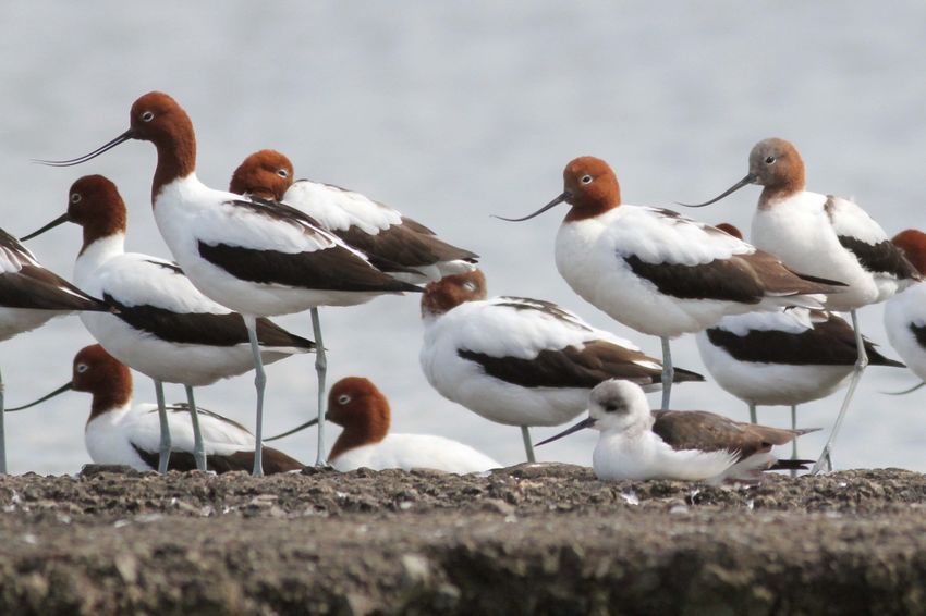
Red-necked avocet (Recurvirostra novaehollandiae) and black-winged stilt (Himantopus
himantopus). C Herbert
vFigure 1 Hunter Wetlands NP Plan of Management
viHunter Wetlands National Park Plan of Management
1. Introduction
1.1 Location, reservation and regional setting
Features Description
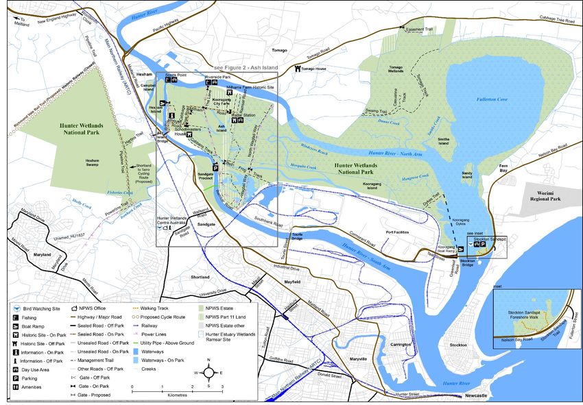
Location Hunter Wetlands National Park (referred to as ‘the park’ in this plan) lies in
the lower estuarine reaches of the Hunter River (see Figure 1 on centre
pages). It borders the city of Newcastle to the south and extends from the
town of Hexham in the west to Stockton and Fern Bay in the east. The park
is in two distinct sections. The eastern part includes: Stockton Sandspit;
Sandy and Smiths islands; the bed of Fullerton Cove; part of the north and
southern arms of the Hunter River, Tomago Wetlands, Kooragang, Ash,
Hexham and Campbell islands. The western part covers Hexham Swamp.
Reservation dates The park was established in 2007 under the Hunter Park Estate (Lower
and previous tenure Hunter Region Reservations) Act 2006. This Act allowed for the revocation of
Kooragang and Hexham Swamp nature reserves and then reserved the
lands formerly in these reserves as Hunter Wetlands National Park.
Ash, Campbell and Hexham islands were later additions to the park and
were previously Crown land managed by the former State Property Authority
and leased to the Hunter-Central Rivers Catchment Management Authority
for the Kooragang Wetland Rehabilitation Project.
The table below shows the area of the park that was originally nature reserve
and other additions. Together the total area for the park is now 4549
hectares.
Previous name Original date of Area
reservation (hectares)
Kooragang Nature Reserve 1983 3348
Hexham Swamp Nature Reserve 1990 905
Other additions From 2007 to 2015 297
Total Area 4549
The park includes 29 kilometres of estuarine foreshore, including the
intertidal zone down to the mean low water mark and the bed of Fullerton
Cove. The plan of management applies to these lands but does not prohibit
any action authorised under the Fisheries Management Act 1994.
The park also includes approximately 27 hectares of the Tomago Sandbeds
Special Area declared under the Hunter Water Act 1991.
The area of park covered by this plan includes 204 hectares of unreserved
lands, which are vested in the Minister administering the National Parks and
Wildlife Act 1974 for the purposes of Part 11 of that Act. These ‘Part 11
lands’ incorporate (see Figure 1 and Section 5):
• an infrastructure corridor
• the Kooragang City Farm Licence Area
• a small area of land at Scotts Point on Ash Island.
Regional context
Biogeographic The park is located within the Hunter subregion of the Sydney Basin
region Bioregion and the Karuah Manning subregion of the NSW North Coast
Bioregion. It forms part of a green corridor stretching from Port Stephens to
the Watagan Ranges. Most of the Hunter Estuary Wetlands Ramsar site is
encompassed by the park (see Section 2.2).
1Hunter Wetlands National Park Plan of Management
Features Description
Surrounding land Land uses surrounding the park include a mix of industrial, agricultural and
use residential uses including: a major coal export loading facility at Kooragang
Island, Tomago aluminium smelter, livestock grazing and rural residential
lands at Tomago and Hexham, and urban development at Hexham and Fern
Bay. To the south of Hexham Swamp, at Shortland, is the Hunter Wetlands
Centre Australia, which is freehold land that was added to the Hunter
Estuary Wetlands Ramsar site in 2002 (see Section 2.2). Public land owned
by Hunter Local Land Services is also located adjacent to the park at
Hexham Swamp.
The park provides a unique backdrop to Newcastle, one of the fastest-
growing regional cities in Australia. The local community rates the
conservation of and recreational access to the park highly.
Other authorities The park is located within the areas of the Awabakal and Worimi local
Aboriginal land councils, Hunter Local Land Services and the City of
Newcastle and Port Stephens local government areas.
1.2 What is special about the park
Natural heritage
The park is part of a green corridor stretching from the Watagan Ranges, through to Hexham
Swamp and Port Stephens (DECCW 2009). The park contributes to the scenic amenity of
the city of Newcastle by providing a green buffer.
The wetland system in the park is of international significance and is listed under the Ramsar
Convention on Wetlands. It is of exceptional conservation value, containing the second
largest area of mangroves in New South Wales and extensive areas of coastal saltmarsh.
The park provides habitat for a diversity of wildlife including 41 threatened species such as
the Australasian bittern (Botaurus poiciloptilus), green and golden bell frog (Litoria aurea)
and breeding habitat for the eastern freetail-bat (Mormopterus norfolkensis).
The park provides important habitat for migratory bird species listed under international
agreements, including the curlew sandpiper (Calidris ferruginea), sharp-tailed sandpiper
(C. acuminata) and the red knot (C. canutus). The park is a site on the East Asian –
Australasian Flyway and is part of the Hunter Estuary Important Bird Area (BirdLife
International 2017).
Cultural landscape
Situated within the Hunter Estuary, the park is part of a broader Aboriginal cultural landscape
that extends east to Stockton Beach and west to the woodland areas and foothills of Minmi.
Rich in traditional food resources and cultural meaning, today the park provides cultural
opportunities for present and future generations of Worimi and Awabakal people and
educational opportunities for the wider community.
Historic heritage
The park contains areas that represent some of Newcastle’s earliest European settler
history, including the early coal and timber industries, quick lime production for colonial
building construction, salt, agriculture and food production and the physical remnants of the
pre-1950s dairying industry. The park contains the 1890 Ash Island Schoolmasters House,
2Hunter Wetlands National Park Plan of Management
which is of local historical significance, and the World War II Radar Station buildings, which
are of state heritage significance (OEH 2015a).
In the late 1800s, Ash Island was home to two of Australia's most skilled natural history
artists, Harriet and Helena Scott. These women recorded the island’s plants and animals,
and went on to become two of the most distinguished illustrators of plants and animals in
late 19th century Australia.
Social value
The park is important to the Newcastle community as a free, accessible, recreational park for
uses such as walking, birdwatching, cycling and fishing. It provides opportunities for special
interest groups including the Kooragang Wetland Rehabilitation Project volunteers, the
Hunter Bird Observers Club and the Rebel Flying Club (model aircraft). The park also offers
unique opportunities for providing information and education on estuarine restoration and
threatened species.
Scientific values
Volunteers, local schools, universities and research institutions have a long history of
involvement in research in the park. The park provides ongoing research potential in the
fields of climate change impacts, estuarine and freshwater wetland rehabilitation, shorebird
behaviour and habitat requirements and the management of threatened species and
communities.
3Hunter Wetlands National Park Plan of Management
2. Management context
2.1 Legislative and policy framework
The management of national parks in New South Wales is in the context of a legislative and
policy framework of the National Parks and Wildlife Service (NPWS), primarily the National
Parks and Wildlife Act and Regulation, the Biodiversity Conservation Act 2016 and NPWS
policies.
Other legislation, strategies and international agreements also apply to management of the
area. In particular, the Environmental Planning and Assessment Act 1979 may require the
assessment of environmental impacts of works proposed in this plan. The NSW Heritage Act
1977 may apply to the excavation of known archaeological sites or sites with the potential to
contain historical archaeological relics. The Commonwealth Environment Protection and
Biodiversity Conservation Act 1999 may apply in relation to actions that impact matters of
national environmental significance, such as migratory and threatened species listed under
that Act, or the hydrology of wetlands of international significance.
A plan of management is a statutory document under the National Parks and Wildlife Act.
Once the Minister has adopted a plan, the plan must be carried out and no operations may
be undertaken in relation to the lands to which the plan relates unless the operations are in
accordance with the plan. This plan will also apply to any future additions to the park. Should
management strategies or works be proposed in future that are not consistent with this plan,
an amendment to the plan will be required.
2.2 Management purposes and principles
National parks are reserved under the National Parks and Wildlife Act to protect and
conserve areas containing outstanding or representative ecosystems, natural or cultural
features or landscapes or phenomena that provide opportunities for public appreciation,
inspiration and sustainable visitor or tourist use and enjoyment.
Under section 30E of the Act, national parks are managed to:
• conserve biodiversity, maintain ecosystem functions, protect geological and
geomorphological features and natural phenomena and maintain natural landscapes
• conserve places, objects, features and landscapes of cultural value
• protect the ecological integrity of one or more ecosystems for present and future
generations
• promote public appreciation and understanding of the park's natural and cultural values
• provide for sustainable visitor or tourist use and enjoyment that is compatible with
conservation of natural and cultural values
• provide for sustainable use (including adaptive reuse) of any buildings or structures or
modified natural areas having regard to conservation of natural and cultural values
• provide for appropriate research and monitoring.
The primary purpose of national parks is to conserve natural and cultural heritage.
Opportunities are provided for appropriate visitor use in a manner that does not damage
conservation values.
Section 30E also explicitly provides for development described in section 185A of the Act to
be undertaken in a ‘special area’ as defined in the Hunter Water Act, having regard to the
conservation of the park’s natural and cultural values. These developments would principally
relate to the purposes of extracting, treating, reticulating or replenishing groundwater.
4Hunter Wetlands National Park Plan of Management
Wetlands of international importance (Ramsar wetlands)
The park encompasses the Kooragang component of the Hunter Estuary Wetlands Ramsar
site. The other, smaller component of the site is the Hunter Wetlands Centre Australia (see
Figure 1). The Hunter Estuary Wetlands Ramsar site was listed under the Ramsar
Convention on Wetlands of International Significance (UNESCO 1971) in 1984. Countries
that are parties to the Convention on Wetlands undertake to implement policies that
guarantee the wise and sustainable use of wetlands.
The Ramsar wetlands site includes the original area that was reserved as Kooragang Nature
Reserve in 1983 and the Hunter Wetlands Centre Australia site at Shortland (previously
known as Shortland Wetlands), which is freehold land that was added to the Ramsar site in
2002.
Management principles for Australian Ramsar sites are established under regulations to the
Environment Protection and Biodiversity Conservation Act. These principles state that the
primary purpose of management of a Ramsar wetland is to describe and maintain the
ecological character of the wetland and to formulate and implement planning that promotes
its conservation and its sustainable use. In addition to the Australian Ramsar management
principles, other guiding principles are established by the Ramsar Convention on Wetlands
and national guidelines, which provide a framework for the Ramsar Convention’s
implementation in Australia. These provide jurisdictions and other interested parties with
clear guidance on the management of Ramsar sites. The above principles and guidelines
have been considered in preparing this plan.
NSW State Heritage Register
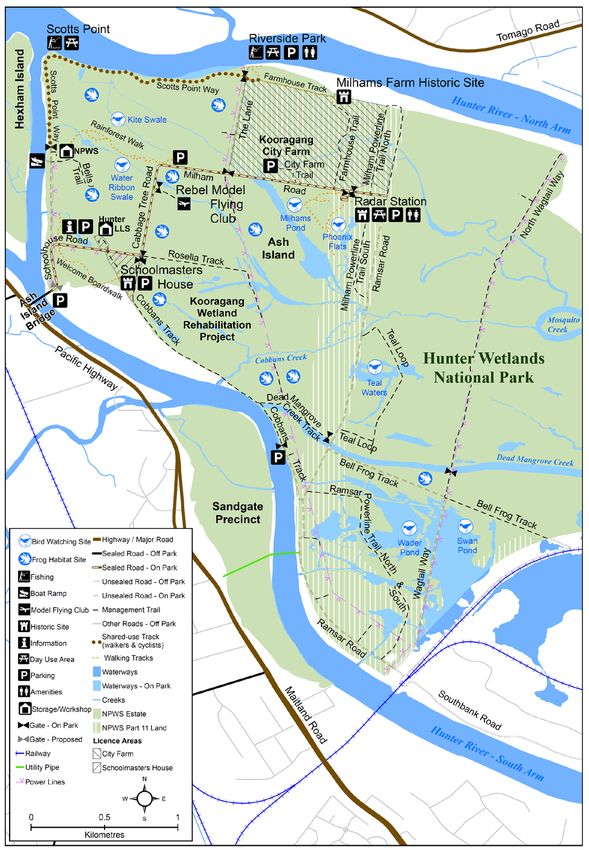
The park contains a collection of buildings associated with a World War II Radar Station (see
Figure 2) that are listed on the NSW State Heritage Register (SHR Listing number 01815).
The Radar Station buildings are in the infrastructure corridor, which are Part 11 lands (see
Sections 1.1 and 5.3). NPWS policy requires all items listed on the State Heritage Register
to have a conservation management plan and be maintained in accordance with best
practice management principles. Under the Heritage Act, all buildings listed on the State
Heritage Register, other than ruins, must meet minimum standards of maintenance and
repair (see Section 3.5).
2.3 Compensatory habitat works
A memorandum of understanding was established between NPWS and the former
Newcastle Port Corporation (now part of the NSW Ports Authority). The outcome of the
memorandum of understanding is that the priority for management in certain areas of Hunter
Wetlands National Park on Ash Island is the construction and management of biodiversity
habitats for green and golden bell frog. Biodiversity offsets are measures that benefit
biodiversity by compensating for adverse impacts of developments that are occurring
elsewhere. The developments that have been offset by works in the park include Newcastle
Coal Infrastructure Group and Broken Hill Proprietary (BHP) Billiton projects on nearby
Kooragang Island. The biodiversity offset strategy is under way with some habitat sites
already established on Ash Island for the green and golden bell frog (see Section 5.2).
In addition, shorebird habitat offsets resulting from planning agreements for rail infrastructure
adjoining Kooragang Island are also being negotiated for other areas in the park on Ash
Island.
5Hunter Wetlands National Park Plan of Management
Figure2 Ash Island (Hunter Wetlands National Park)
6Hunter Wetlands National Park Plan of Management
2.4 Specific management directions
The park lies within a highly modified and evolving estuarine and freshwater environment.
Key challenges for park management are the significant predicted growth in the Hunter
Region’s population, the growing popularity of outdoor recreational activities and the
neighbouring port, which is the largest coal exporting port in the world (see Figure 1, port
facilities along Cormorant Road).
It is recognised that reinstating the original wetland environment is not achievable throughout
the park. Instead, the primary management objectives are to protect the internationally
important wetlands and to provide for sustainable visitor use and enjoyment.
A plan of management prepared for Kooragang and Hexham Swamp nature reserves was
adopted in 1998. These reserves were revoked and re-reserved as part of Hunter Wetlands
National Park (see Section 1.1). Key management directions from the Kooragang Nature
Reserve and Hexham Swamp Nature Reserve Plan of Management (NPWS 1998) have
been incorporated into this plan.
This plan provides a management framework to ensure that key conservation objectives are
met while recognising the increased emphasis on recreational opportunities for the future. In
addition to the general principles for the management of national parks (see Section 2.2), the
following specific management directions apply to the management of the park:
• Increase shorebird, fish and estuarine habitats and rehabilitate estuarine and freshwater
wetlands through water management and mangrove removal.
• Manage the Ramsar-listed wetland to reduce the effects of habitat loss and
fragmentation by restoring and protecting habitat and diversity, and through
implementing appropriate pest and weed control programs.
• Rehabilitate and remediate acid sulfate soils through the inundation of wetland areas.
• Conserve and manage the sites of historic importance including the state-listed World
War II Radar Station buildings.
• Manage Aboriginal cultural heritage in consultation with the Awabakal and Worimi
traditional owners through the conservation of archaeological sites, the interpretation of
the cultural landscape, and the provision of opportunities for employment and cultural
experiences for the Aboriginal community.
• Provide a range of ecologically sustainable, nature-based recreational and educational
opportunities that are consistent with the park’s conservation significance.
• Work with and continue to support volunteers and educational institutions to undertake
research projects and monitoring activities in the park.
• Ensure non-park infrastructure is managed in accordance with the conservation values
of the park.
7Hunter Wetlands National Park Plan of Management
3. Values
This plan aims to conserve and enhance the exceptional natural values as well as the
cultural values of the park. To make this plan clear and easy to use, various aspects of
natural heritage, cultural heritage, threats and ongoing use are dealt with individually,
although these features are interrelated.
3.1 Geology, landscape and hydrology
The park lies in the eastern, coastal margin of the lower Hunter Estuary. It is situated in a
system characterised by complex and interdependent interactions between the Hunter River,
tributary channels, the sea and a mosaic of mudflats, beaches, sand spits, mangrove
forests, saltmarsh, freshwater wetlands and grassland with floodplain woodland and
rainforest on upland areas.
The Hunter River begins in the Mount Royal Range on the western side of Barrington Tops
and is the largest coastal catchment in New South Wales. Two rivers, the Paterson and
Williams, flow into the Hunter Estuary and drain into the north-east of the Hunter River
catchment area. The tidal limit for the Paterson River occurs between Paterson and
Gostwyck, approximately 70–75 kilometres from the ocean, and at Seaham Weir on the
Williams River, approximately 46 kilometres from the ocean (MHL 2003).
The geomorphic characteristics are those of a typical graded alluvial river and associated
floodplain. The character of the estuary transitions from river flats to an estuarine delta below
Hexham. The Hunter River deposits sand and silt by way of the two main river channels: the
north arm and south arm (see Figure 1). The north arm of the river opens into a shallow,
circular embayment called Fullerton Cove. The river exits the estuary into the Pacific Ocean
between Pirate Point at Stockton and the rocky outcrops of Nobbys Head. The dominant
island in the lower estuary is the man-made Kooragang Island at the mouth of Fullerton
Cove, which represents the remnants of the island delta comprised of up to 10 other islands
(Williams et al. 2000).
More than 200 years of European intervention has altered the hydrology of the estuary
through the construction of drainage and flood mitigation systems as well as dredging
activities to aid shipping movements. The associated infrastructure includes more than 112
culverts, bridges and floodgates, and 77 kilometres of drains and levees (Williams et al.
2000; KWRP 2005). All these works have resulted in significant changes to the geology and
hydrology of the landscape across large areas of the park. The Hunter Valley Flood
Mitigation Act 1956 allowed for the construction in 1976 of a significant, 12-kilometre long
levee bank in the park around Fullerton Cove for flood mitigation. Major floodgates were
installed in 1971 on Ironbark Creek at Hexham Swamp under the provisions of the Act to
increase agricultural and grazing opportunities.
Kooragang Island has progressively been altered through reclamation, river stabilisation
works and dredging to create the Newcastle port facilities. Channels have also been
deepened to allow for shipping movements in the south arm of the river. The land
reclamation works had predominantly been completed before the gazettal of Kooragang
Nature Reserve in 1983. Kooragang Dyke, on the northern side of Kooragang Island, was
constructed in the 1960s and is a series of rock dyke walls approximately 1.5 kilometres in
length. The dyke was constructed in preparation for infilling the area for industrial
development, but the project was subsequently abandoned and is now an important habitat
feature.
Soils in the park are characterised by sediments from further upstream that have been
deposited in swamps and mud flats. They contain black silty and highly saturated soft clays
8Hunter Wetlands National Park Plan of Management
with underlying light grey silty sand (NPWS 1998). In some areas of the park the soils are
typically strongly leached and are acid throughout the profile.
Acid sulfate soils, a naturally occurring feature of estuaries along the eastern Australian
coastline, are historically incompatible with traditional agricultural land use. There is a high
risk of acid sulfate soil in several areas within the park (DPI 2008). Some areas in the park,
for example near Tomago Wetlands, have a history of wetland drainage which has led to the
oxidisation of sulfidic soils resulting in acid leaching from the soil and causing water quality
problems.
Issues
• The Hunter River has had a history of major flooding, and it is predicted that climate
change will lead to increased coastal flooding and storms (see Section 4.4). This will
influence how the park is managed with respect to the location of infrastructure and the
management of floodgates and other flood mitigation structures.
• The Hunter Valley Flood Mitigation Scheme continues to operate under the powers of
the Water Management Act 2000 (see Section 5).
• Pollution events that have impacted on the park’s conservation values include:
o the discharge of 72,000 litres of heavy fuel oil by the MS Magdalene in 2010, which
impacted waterbirds, saltmarsh, mangroves and invertebrates living in the mudflats
at Stockton Sandspit and Fullerton Cove
o groundwater contamination by per-fluoroalkyl and poly-fluoroalkyl substances (or
‘PFAS’) sourced from the Williamtown Airforce Base, which triggered a 12-month
closure of Fullerton Cove to fishing during 2015–16.
• The cumulative impacts from past, current and future activities in and adjacent to the
park are poorly understood. Industrial, agricultural and residential activities can affect
the sensitive ecosystem health of the estuary through dredging and industrial and urban
discharges (including wastewater, stormwater, sewage and oil spills).
• Acid sulfate soil runoff can also impact water quality and estuarine ecosystems. Historic
drainage, floodgates and levees have altered the geology, landscape and hydrology
with legacies such as acid sulfate soils and changes to freshwater input from
neighbouring developments that will continue to need management into the future.
• The drains need to occasionally be cleared in the Tomago Wetlands and a drain
management plan needs to be prepared in accordance with the NSW Environment
Protection Authority guidelines for managing acid sulfate soils (Tulau 2007).
• Channel dredging may be linked to increased tidal range. This has resulted in significant
ecological change through saltmarsh loss and mangrove expansion (see Section 5.2).
Desired outcomes
• The sensitive environments in the park are protected from further impacts.
• The impacts of pollution on air and water quality are reduced.
• The environmental impacts of increased tidal range on saltmarsh and mangroves are
reduced.
• The negative impacts of acid sulfate soil on water quality and estuarine habitat are
reduced.
9Hunter Wetlands National Park Plan of Management
Management response
3.1.1 Actively manage the hydrology using water management structures. Manage specific
areas of mangroves to minimise the effects of the tidal range changes on habitat
loss.
3.1.2. Contribute to the preparation of emergency risk planning with NSW Ports Authority
for the management of oil/chemical spills.
.3.1.3. Establish and maintain oiled fauna rescue and rehabilitation preparedness with other
stakeholders, in particular the port authority and wildlife rescue organisations.
3.1.4. Contribute to management strategies for the prevention of stormwater pollution of
waterways in the Hunter Estuary with local councils.
3.1.5. Cooperate with other agencies in responding to pollution events, including testing
and monitoring of contamination.
3.1.6. Manage the impact of acid sulfate soil on the park’s waterways by flushing strategies
including opening floodgates.
3.1.7. Contribute to strategic reviews of the Hunter Valley Flood Mitigation Scheme with the
aim of improving wetland values.
3.2 Native plants
The park is a coastal vegetation ecosystem containing estuarine tidal and intertidal zones of
brackish and freshwater wetlands, with grassland, floodplain forest and rainforest at slightly
higher elevations.
Primarily the park supports estuarine vegetation including extensive areas of mangrove
forest, swamp oak forest and saltmarsh. The mangrove areas are dominated by grey
mangrove (Avicennia marina) and to a lesser extent river mangrove (Aegiceras
corniculatum).
Areas with fresh or brackish water contain freshwater wetlands with a variety of salt-tolerant
native sedges and grasses. The common reed (Phragmites australis) forms extensive
monocultures in Hexham Swamp and Tomago Wetlands, which is consistent with highly
disturbed ecosystems (Chambers et al. 2012). Narrow-leaved cumbungi (Typha
domingensis) is found in Tomago Wetlands, on Ash Island and in areas surrounding
Hexham Swamp.
There are five vegetation communities in the park that are listed as threatened ecological
communities under the Biodiversity Conservation Act (see Table 1).
Table 1: Threatened ecological communities in the park
Community name (short title) * BC Act status Area
(hectares)
Freshwater Wetlands on Coastal Floodplains Endangered 854
Coastal Saltmarsh Endangered # 559
Swamp Oak Floodplain Forest Endangered 104
Swamp Sclerophyll Forest on Coastal Floodplains Endangered 8
Lowland Rainforest Endangered 0.33
BC Act = Biodiversity Conservation Act.
* all of these communities are found in the North Coast, Sydney Basin and South East Corner bioregions.
# listed as vulnerable under the Environment Protection and Biodiversity Conservation Act.
10Hunter Wetlands National Park Plan of Management
There are large areas of endangered coastal saltmarsh throughout the park, with the
dominant species being samphire (Sarcocornia quinqueflora) and saltwater couch
(Sporobolus virginicus). In slightly higher elevation areas on the floodplain, the park is
interspersed with pasture and some remnant rainforest areas. There are very small patches
of lowland rainforest on the western side of Ash Island (Kleinfelder 2016). Other slightly
elevated areas also contain remnant pockets of swamp oak (Casuarina glauca) and
Melaleuca spp., in particular in areas on Ash Island, Hexham Swamp and at Tomago and
Kooragang wetlands.
The park supports three threatened plants (see Table 2).
Strategies for the recovery of threatened species, populations and ecological communities
have been set out in a statewide Biodiversity Conservation Program (formerly known as the
Threatened Species Priorities Action Statement [DECC 2007]). These actions are currently
prioritised and implemented through the Saving our Species program, which aims to
maximise the number of threatened species that can be secured in the wild in New South
Wales for 100 years (OEH 2013b).
Table 2: Threatened plants recorded in the park
Common name Scientific name BC Act status EPBC Act
status
Maundia triglochinoides Vulnerable
White-flowered wax plant Cynanchum elegans Endangered Endangered
Zannichellia palustris Endangered
BC Act = Biodiversity Conservation Act.
EPBC Act = Environment Protection and Biodiversity Conservation Act.
Saltmarsh and mangroves
The park has a long history of human intervention that has affected the original ecosystem.
A main objective for the park is to enhance and protect areas of original saltmarsh in order to
expand nursery habitat for estuarine species and to expand habitat for shorebirds. This is
being achieved through controlled reintroduction of tidal flows from the Hunter River to
create a saltmarsh mosaic, and through targeted strategic removal of mangroves as well as
control of exotic spiny rush (Juncus acutus). The reintroduction of tidal flows to create
saltmarsh has seen a rapid proliferation of spiny rush (see Section 4.2) in some areas, as
native and exotic freshwater species are replaced by more salt-tolerant species.
Areas of saltmarsh in the Hunter Estuary have reduced due to the expansion of mangrove
communities. The Ecological Character Description prepared for the Hunter Estuary
Wetlands Ramsar site identified saltmarsh loss as an unacceptable change in the ecological
character of the site (DSEWPC 2010). To address this, restoration works commenced on
Ash Island, Stockton Sandspit and other smaller areas in the early 2000s. Restored areas of
wetland at Tomago and Hexham Swamp now have significant areas of saltmarsh that
support large numbers of migratory birds.
In New South Wales, mangroves are protected under the Fisheries Management Act. The
removal of mangroves in the park is subject to a licence with the relevant regulatory
authority. At significant migratory shorebird sites within the park, programs for mangrove
control have been implemented to maintain saltmarsh integrity and shorebird habitat. These
areas include Windeyers Reach, Kooragang Dykes, Ash Island, Stockton Sandspit, Sandy
and Smiths islands, Tomago Wetlands and some areas of lands associated with the
compensatory habitat works (see Figure 1). Approximately 470 hectares in the park are
subject to mangrove seedling removal to preserve migratory wader habitat. Any removal of
11Hunter Wetlands National Park Plan of Management
mangroves is conducted under licence and in consultation with local officers from the
relevant regulatory authority.
A saltmarsh action plan (OEH 2016) for the park has been prepared to manage the
expansion of this threatened community. This plan includes monitoring of shorebird
populations and mapping of saltmarsh areas.
Stockton Sandspit is an artificially created landscape formed from dredge spoil from the
building of Stockton Bridge in 1971 (Herbert 2007a). The sandspit is comprised mainly of a
lagoon, open sand and saltmarsh, which is maintained to maximise bird roosting, foraging
and nesting habitat. Habitat along the southern edge of the sandspit is being optimised by
mangrove and weed removal and by plantings of local coastal species. On the northern river
edge, the spit is fringed by mangroves and mudflats extending north up the river channel to
Fullerton Cove.
Sandy and Smiths islands are two of the few remaining intact islands in the estuary. They
support saltmarsh meadow, pockets of coastal banksia (Banksia integrifolia), swamp oak,
common reed and exotic species such as bitou bush (Chrysanthemoides monilifera) in
between brackish wetland.
At Tomago Wetlands, the park extends from an estuarine wetland of mangrove forest,
through to swamp oak forest in brackish water, freshwater swamp oak forest, to swamp
sclerophyll forest. In drier areas, smooth-barked apple (Angophora costata) and banksia
woodland are common. Tomago Wetlands was previously a mosaic of saltwater and
brackish environments dominated by saltmarsh.
Kooragang Island extends from Stockton Bridge to Mosquito Creek and is characterised by
saltmarsh and mangrove forest with isolated pockets of swamp oak forest. Introduced kikuyu
(Pennisetum clandestinum) pasture is predominant in higher areas, a legacy of previous
farming activities. The non-tidal areas would have previously supported forests of swamp
oak, Melaleuca spp., cabbage tree palms (Livistona australis) and other rainforest species
which were cleared for agricultural purposes.
Ash Island was once a distinct island separated from Kooragang Island by Mosquito Creek.
The creek was in-filled in the 1960s and Ash Island became the western part of Kooragang
Island. Ash Island and the other lower Hunter River islands originally contained lowland
rainforest on floodplain, a threatened ecological community that now occurs only as small
remnants scattered on the NSW north coast. A project to reinstate rainforest on sections of
Ash Island commenced in 1993. This project is now part of the Kooragang Wetland
Rehabilitation Project, which is currently managed by Hunter Local Land Services under
licence (see Section 5.2). Freshwater swales with kikuyu pasture dominate the northern end
of Ash Island while the southern and eastern areas of Ash Island are characterised by
mangrove and saltmarsh vegetation (Land Systems EBC 1994; Winning 1996).
Hexham Swamp once supported extensive areas of estuarine wetlands. Historic vegetation
surveys identified eight vegetation types including mangroves, saltmarsh and brackish
grassland. Hexham Swamp covers approximately 2500 hectares of the 12,500-hectare
Ironbark Creek catchment and drains into the Hunter River. Water flowing down Blue Gum
and Ironbark creeks is captured on the floodplain creating Hexham Swamp. In 1971 the
construction of floodgates on Ironbark Creek drained the swamp and inhibited tidal flows
entering the swamp from the Hunter River.
Issues
Vegetation communities in the park have been significantly altered by the construction of
flood mitigation and drainage structures, dredging of estuarine channels and clearing for
agriculture and grazing. The management directions include protecting and rehabilitating
wetland vegetation communities that historically would have been present before structures
12Hunter Wetlands National Park Plan of Management
were installed, while recognising that complete reversal to the original vegetation community
structure is not possible. In specific areas of the park there is a need to manually remove
mangroves to allow saltmarsh to expand and to reintroduce and manage tidal flows.
Desired outcomes
• A strategic approach is utilised to manage saltmarsh habitats, in particular through
mangrove removal, wetland restoration and management of tidal flows.
• Threatened plant species, populations and ecological communities are conserved.
• Negative impacts on threatened plants species and communities are minimised.
• Structural diversity and habitat values are restored in degraded areas.
• The ecology and conservation needs of the park are improved through research.
Management response
3.2.1. Implement a strategic, project-based approach to shorebird habitat enhancement by
way of wetland restoration, management of tidal flows and selected mangrove
removal in the park.
3.2.2. Implement relevant strategies in the Biodiversity Conservation Program for
threatened species, populations and ecological communities present in the park.
3.2.3. Support and encourage strategic rehabilitation works in the broader Hunter Estuary
by agencies, conservation groups and not-for-profit organisations.
3.2.4. Encourage further research and planning on the park’s vegetation, in particular, the
distribution, migration pathways, ecology and management needs of threatened
species and communities.
3.3 Native animals
In 2011, a baseline fauna survey was undertaken in the park and 110 fauna species were
recorded, including 62 birds, 24 mammals, 14 frogs and 10 reptiles (Ecobiological 2011).
Table 3 lists the 41 threatened animal species recorded in the park.
Table 3: Threatened animals recorded in park
Common name Scientific name BC Act status EPBC Act status
Frogs
Green and golden bell Litoria aurea Endangered Vulnerable
frog
Birds
Australasian bittern Botaurus poiciloptilus Endangered Endangered
Bar-tailed godwit Limosa lapponica Vulnerable
Migratory
Beach stone-curlew Esacus magnirostris Critically
Endangered
Black falcon Falco subniger Vulnerable
Black-necked stork Ephippiorhynchus asiaticus Endangered
Black-tailed godwit Limosa limosa Vulnerable Migratory
13Hunter Wetlands National Park Plan of Management
Common name Scientific name BC Act status EPBC Act status
Broad-billed sandpiper Limicola falcinellus Vulnerable Migratory
Comb-crested jacana Irediparra gallinacea Vulnerable
Curlew sandpiper Calidris ferruginea Endangered Critically endangered
Migratory
Eastern curlew Numenius Critically endangered
madagascariensis Migratory
Eastern grass owl Tyto longimembris Vulnerable
Eastern osprey Pandion cristatus Vulnerable
Freckled duck Stictonetta naevosa Vulnerable
Greater sand plover Charadrius leschenaultii Vulnerable Migratory
Great knot Calidris tenuirostris Vulnerable Migratory
Lesser sand plover Charadrius mongolus Vulnerable Migratory
Little eagle Hieraaetus morphnoides Vulnerable
Little lorikeet Glossopsitta pusilla Vulnerable
Little tern Sternula albifrons Endangered Migratory
Magpie goose Anseranas semipalmata Vulnerable
Painted snipe Rostratula australis Endangered Endangered
Migratory
Pied oystercatcher Haematopus longirostris Endangered
Red knot Calidris canutus Endangered
Migratory
Sanderling Calidris alba Vulnerable Migratory
Sooty oystercatcher Haematopus fuliginosus Vulnerable
Spotted harrier Circus assimilis Vulnerable
Square-tailed kite Lophoictinia isura Vulnerable
Terek sandpiper Xenus cinereus Vulnerable Migratory
Varied sittella Daphoenositta chrysoptera Vulnerable
White-bellied sea-eagle Haliaeetus leucogaster Vulnerable
White-fronted chat Epthianura albifrons Vulnerable
Mammals
Eastern bentwing-bat Miniopterus schreibersii Vulnerable
oceanensis
Eastern false pipistrelle Falsistrellus tasmaniensis Vulnerable
Eastern freetail-bat Mormopterus norfolkensis Vulnerable
Greater broad-nosed bat Scoteanax rueppellii Vulnerable
Grey-headed flying-fox Pteropus poliocephalus Vulnerable Vulnerable
Large-eared pied bat Chalinolobus dwyeri Vulnerable Vulnerable
Little bentwing-bat Miniopterus australis Vulnerable
Southern myotis Myotis macropus Vulnerable
14Hunter Wetlands National Park Plan of Management
Common name Scientific name BC Act status EPBC Act status
Yellow-bellied sheath-tail Saccolaimus flaviventris Vulnerable
bat
BC Act = Biodiversity Conservation Act.
EPBC Act = Environment Protection and Biodiversity Conservation Act.
The endangered green and golden bell frog was first recorded in the northern end of the
park at Ash Island in 1997. This species has subsequently been found in a number of
habitats in the park including both freshwater and brackish swales. Green and golden bell
frog habitat is being constructed on Ash Island through the compensatory habitat offset
program and will become a significant asset in the park (see Section 5.2).
Two of the most notable of the 10 species of reptile recorded in the park include the
mainland she-oak skink (Cyclodomorphus michaeli) and the tree skink (Egernia mcpheei),
believed to be at the southernmost extent of their range. The casuarina forests at Tomago
Wetlands and Ash Island provide the most diverse reptile habitat in the park. The red-bellied
black snake (Pseudechis porphyriacus), eastern brown snake (Pseudonaja textilis) and
black-bellied swamp snake (Hemiaspis signata) are common.
Native terrestrial mammals recorded in the park include the brown antechinus (Antechinus
stuartii), swamp rat (Rattus lutreolus) and the eastern grey kangaroo (Macropus giganteus).
The park does not include large connected patches of woodland which are required to
support other local macropod species, such as the swamp wallaby (Wallabia bicolor) and the
red-necked wallaby (Macropus rufogriseus) (Ecobiological 2011).
The park is home to a significant number of micro-bat species currently listed as vulnerable
under the Biodiversity Conservation Act, including the eastern freetail-bat. This species was
first recorded in significant numbers on Ash Island in 2009 with maternity colonies roosting in
mature mangrove hollows (McConville 2011). The southern myotis and yellow-bellied
sheathtail-bat (both threatened) have been recorded at Ash Island and Kooragang Island
adjacent to the coal port facilities.
The Hunter Estuary is considered one of the most important coastal estuaries in New South
Wales and supports an abundance and diversity of bird life. This was the primary reason for
the original gazettal of the Kooragang Nature Reserve and its subsequent Ramsar listing in
1984 (see Section 2.2). It supports birds in all stages of their life cycle including breeding,
migration stopover, roosting, foraging and drought refuge (DSEWPC 2010). At least 42
migratory species listed on the Environment Protection and Biodiversity Conservation Act
have been recorded in the park. Over 190 species of birds have been recorded on Ash
Island since 1980. The Hunter Estuary, including the park, is also listed as an Important Bird
Area because of the diversity and numbers of migratory birds that the wetland supports.
The estuary is situated near the southern end of the East Asian – Australasian Flyway. The
flyway extends from within the Arctic Circle, through Russia, East and South-east Asia, to
Australia and New Zealand, stretching across 22 countries (EAAFP 2014). Approximately 55
migratory species travel along it, which includes about five million birds.
Migratory species need stepping stones of suitable habitat along the flyway, such as the
Hunter Wetlands, where they can feed, fatten up and rest before they start their arduous
journey back to the northern hemisphere for the breeding season.
Since European settlement of the estuary, shorebird habitat has significantly declined.
Human-induced impacts both directly within the estuary and along the East Asian –
Australasian Flyway are thought to be related to the decline of migratory shorebirds. To
address declining habitat, there are currently a number of significant projects undertaking
rehabilitation and protection works within the park.
The Tomago Wetland Rehabilitation Project aims to rehabilitate 500 hectares of drained
agricultural land, through tidal inundation from the Hunter River and management of flood
15Hunter Wetlands National Park Plan of Management
mitigation infrastructure. In 2012, migratory shorebirds were recorded at Tomago Wetlands
for the first time since the 1970s. There has been an associated increase in available
vegetated estuarine habitat for aquatic species as a result of these works.
The Hexham Swamp Rehabilitation Project aims to restore 700 hectares of estuarine
woodland both within the park and in land owned and managed by Hunter Local Land
Services (see Section 5.2). The Hunter Local Land Services project is aiming to rehabilitate
estuarine habitat for fish and prawn nurseries habitat, and to increase the diversity and
numbers of shorebirds. Rehabilitation has involved the staged opening of the Ironbark Creek
floodgates, which were originally installed in the 1970s.
Other key areas of shorebird habitat within the park being rehabilitated include:
• Kooragang Dykes, part of which has been stabilised and raised to provide roosting
habitat
• Windeyers Reach and Ash Island, where saltmarsh is being maintained through
strategic mangrove removal
• Stockton Sandspit, which has had a rehabilitation project since 2000 with the active
support of Hunter Bird Observers Club volunteers.
Rehabilitation works throughout the park have contributed to a large increase in shorebird
habitat in the area. Monitoring of shorebird numbers and habitat are undertaken monthly by
the Hunter Bird Observers Club. This group makes a significant contribution to the existing
knowledge of shorebird habitat and provides advice on management directions.
As for plants, strategies for the recovery of threatened animal species and populations have
been set out in the statewide Biodiversity Conservation Program (formerly known as the
Threatened Species Priorities Action Statement [DECC 2007]) and prioritised and
implemented through the Saving our Species program.
Issues
• With declining available habitat, continuing industrial development and ‘coastal
squeeze’, the ability to geographically expand the shorebird habitat or allow for
vegetation community migration is limited (see Section 4.1).
• Kooragang Dykes and Stockton Sandspit are key shorebird habitat areas that can be
impacted by disturbance from visitors accessing these areas for recreation, boating and
fishing purposes (see Section 3.6).
• The amphibian chytrid fungus is a significant threat to the green and golden bell frog
and is found on Kooragang Island and at Hexham Swamp.
• There is the potential for pollution events in the estuary to affect large areas of shorebird
roosting and feeding habitat.
Desired outcomes
• Negative impacts on threatened species are minimised.
• The habitat and populations of threatened animal species are protected and maintained.
• Human disturbance to roosting and foraging shorebirds is minimised, particularly in the
months before northwards migration (i.e. between January and April) and disturbance to
nesting shorebirds at Stockton Sandspit is minimised, especially during spring.
• Structural diversity and habitat values are restored in degraded areas.
• Pollution events are prevented.
16Hunter Wetlands National Park Plan of Management
Management response
3.3.1. Continue implementing existing significant wetland restoration projects and seek
opportunities to improve habitat through targeted restoration projects.
3.3.2. Implement relevant strategies in the Biodiversity Conservation Program for
threatened animal species and populations.
3.3.3. Undertake strategic removal of mangroves in the park to rehabilitate bird habitat.
3.3.4. Support Hunter Bird Observers Club in their shorebird monitoring, habitat restoration
and research activities throughout the park.
3.3.5. Support the research programs for green and golden bell frogs, including research on
chytrid fungus.
3.3.6. Work with the port authority to ensure a rapid and effective response should an oil
spill or pollution incident occur.
3.4 Aboriginal connections to Country
The land, water, plants and animals within a landscape are central to Aboriginal spirituality
and contribute to Aboriginal identity. Aboriginal communities associate natural resources
with the use and enjoyment of foods and medicines, caring for the land, passing on cultural
knowledge, kinship systems and strengthening social bonds. Aboriginal heritage and
connection to nature are inseparable and need to be managed in an integrated manner
across the landscape.
Although the NSW Government has legal responsibility for the protection of Aboriginal sites
and places, NPWS acknowledges the right of Aboriginal people to make decisions about
their own heritage. Aboriginal communities will be consulted and involved in managing
Aboriginal sites, places and related issues; and in promoting and presenting Aboriginal
culture and history.
The park is part of Country for the Awabakal People and the Worimi People. Awabakal
Country stretches south from the Hunter River, including Newcastle; and Worimi Country lies
to the north and east of the Hunter River.
The Hunter Estuary supports an abundance of food resources including freshwater,
estuarine and coastal shellfish and crustaceans, fish, eels, waterbirds and small and large
mammals. Early 19th century Europeans observed local Awabakal People to be tall and
healthy, an indication that they had access to a varied food supply (Rappoport 2010).
The Gathang (Warrimay) local language dictionary contains a rich vocabulary for resources
related to the estuary including: mundal (net), muting (fishing spear), guuyang (canoe),
marine and terrestrial animals and plants including bitjagang (cockles, mussels), dhirrabuwi
(oyster), gatigan (mud crab) and over 17 species of fish (Lissarrague 2010).
Archaeological sites are evidence of Aboriginal occupation that relate to a range of other
aspects of Aboriginal cultural heritage. They are important evidence of Aboriginal history and
are part of the culture of local Aboriginal people today.
Sites of particular cultural significance exist in the park’s vicinity. Archaeological sites are of
high significance to the Awabakal and Worimi peoples because they provide a tangible
connection to cultural practices and their ancestors.
Limited archaeological sites have been recorded in the park, mainly as a result of the park
being a wetland environment and also due to the history of development and modifications
to the landscape. These factors, together with sea level rise over the last 6,000 to 12,000
years, have potentially impacted existing Aboriginal sites that are now part of an ancient,
underwater coastline.
17Hunter Wetlands National Park Plan of Management
Issues
• There are limited records of archaeological sites in the park, partly as a consequence of
data not being appropriately recorded when archaeological investigations are
undertaken.
Desired outcome
• The Worimi and Awabakal Aboriginal communities are involved in management of the
Aboriginal cultural values of the park so that impacts on heritage values are minimised
and cultural values are better understood.
Management response
3.4.1. Encourage opportunities for the Awabakal and Worimi Aboriginal communities to be
involved in rehabilitation work in the park.
3.4.2. Continue to consult and involve the Awabakal and Worimi local Aboriginal land
councils, other relevant Aboriginal community organisations and custodial families in
the management of their Country, including the management of Aboriginal sites and
places, and cultural and natural values.
3.4.3. Ensure that any archaeological sites found are appropriately recorded and that
information is shared with the local Aboriginal community.
3.4.4. Encourage further research into the Aboriginal cultural heritage values of the park
with the Awabakal and Worimi local Aboriginal land councils and other relevant
Aboriginal community organisations.
3.4.5. Provide opportunities for Aboriginal people to access Country, to maintain, renew or
develop cultural practices and associations.
3.4.6. Permit cultural resource use where in accordance with NPWS policy and legislation.
3.5 Shared heritage
Heritage places and landscapes are made up of living stories as well as connections to the
past that individuals and communities have inherited from the past and wish to conserve for
current and future generations, and can include natural resources, objects, customs and
traditions. Cultural heritage consists of places and items that may have historical, scientific,
cultural, natural, archaeological, architectural, aesthetic and social significance. NPWS
conserves the significant heritage features of NSW parks.
When first explored by Europeans, the Hunter River was heavily timbered with mangroves in
the lower tidal reaches and rainforest thickets behind the mangroves. Areas of low-lying land
as well as higher ground with shrubby tall open forest dominated the area. Reeds and
rushes fringed the river banks and many of the lagoons (Rappoport 2010).
The Awabakal and Worimi peoples made first contact with Europeans when convicts
guarded by soldiers were sent to the mouth of the Hunter River to collect coal after its
discovery in 1797. Some convicts escaped and lived in the Port Stephens area with the local
Worimi People, who considered convicts to be reincarnations of people in their family group
(Rappoport 2010).
When the Newcastle convict settlement was established in 1804, the Awabakal and the
Worimi mingled freely with the Europeans and relations between the two groups were
considered to be affable. The Awabakal also supplied food to the settlement and often took
free men on hunting and fishing expeditions (Rappoport 2010). Newcastle developed into an
18You can also read