Archaeological excavations at the Station Bay pä, Motutapu Island, inner Hauraki Gulf, New Zealand - Te Papa
←
→
Page content transcription
If your browser does not render page correctly, please read the page content below
Tuhinga 24: 5–47                                                        Copyright © Te Papa Museum of New Zealand (2013)

   Archaeological excavations at the Station Bay pä,
       Motutapu Island, inner Hauraki Gulf,
                    New Zealand

                                                  Janet Davidson
                        Honorary Research Associate, Museum of New Zealand Te Papa Tongarewa
                               2324 Queen Charlotte Drive, RD1 Picton, New Zealand
                                     (janet.davidson@university-of-ngakuta.ac.nz)

                 ABSTRACT: Excavations at the Station Bay pä on Motutapu in 1970–71 revealed a
                 complex sequence, from a relatively extensive open settlement to a more compact fortifica-
                 tion between about AD 1500 and 1800. Charcoal analysis portrays a largely scrub-covered
                 landscape with only a few trees. Food-storage pits and faunal remains reflect a subsistence
                 economy based on kümara (sweet potato) cultivation and the harvesting of marine resources:
                 shellfish from the adjacent rocky shore and both protected and exposed sandy beaches, and
                 fish, predominantly snapper, from fishing grounds nearby. The few items of material culture
                 are typical of Mäori assemblages of the time.
                     Results of two previous excavations of undefended settlements in the immediate vicinity
                 help to expand a picture of a relatively stable and peaceful way of life, punctuated by periodic
                 episodes of stress when the fortifications were built and rebuilt. External contacts are
                 indicated by imported obsidian, mostly from nearby Great Barrier Island (Aotea Island).
                     The Station Bay excavations are discussed in the context of more than 50 years of
                 archaeological research on Motutapu, which has a largely intact pre-European cultural
                 landscape in close proximity to the large Auckland urban area, where many pre-European
                 sites have been lost.

                 KEYWORDS: Motutapu Island, Station Bay, pä, settlement pattern, faunal analysis.

                  Introduction                                      parts, where Station Bay is situated, are formed of ancient
                                                                    greywacke of the Waipapa Formation; the west and south
Excavations were carried out at the pä at Station Bay in the
                                                                    consist of the Lower Miocene Waitemata series (Mayer
northeast part of Motutapu Island in the summer of 1970–
                                                                    1968). Almost the entire island was blanketed by volcanic ash
71. The results were briefly summarised shortly afterwards
                                                                    erupted from Rangitoto at an early point in the Mäori occu-
(Davidson 1972). A full report is presented here.
                                                                    pation of the Auckland region.
                                                                       The island’s geology made it attractive for Mäori. The
             The site and its setting                               Waipapa greywacke and chert were important resources for
Motutapu is a fertile, undulating island, about 1500 ha in          tool manufacture for much of the period the island was occu-
area, lying just to the northeast of Auckland’s youngest            pied by Mäori. In addition, soils developed on the Rangitoto
volcano, Rangitoto, in the inner Hauraki Gulf (Fig. 1). Its         ash seem to have been well suited to Mäori horticulture.
highest point is 121 m above sea-level, and much of the                Surprisingly, the vegetation history of the island is not
central part is above 90 m. The island is made up of two            well documented, although Esler (1980) provided a detailed
different geological formations. The northern and eastern           description of the state of vegetation after more than a
6   Tuhinga, Number 24 (2013)

                                                                 The Noises

                                                             Rakino

                                           Motutapu                       Station Bay

                                       Rangitoto
                                                                                    Waiheke

                                                            Motuhe
       Waitemata Harbour                            Motukorea
                                                                                                                            N
                                                                                                              Ponui
                                                                            Galatea Bay
                  Auckland Isthmus

              Mt Wellington                                                                          Pakihi

    Manukau Harbour
                                                                      0                  10                     20
                                                                                         km

Fig. 1 The position of Motutapu in the inner Hauraki Gulf near Auckland. Sites in the area beyond the island, referred to in the
text, are also shown.

century of farming, finding 139 native species compared             misinterpreted Smith’s (1909) translation of D’Urville’s
with 207 exotics. Miller et al. (1994: 68) cited unpublished       account of his visit to the area in 1827. In both Smith’s and
palynological data indicating that the island was once covered     Wright’s (1950: 153) translations, it was Rangitoto rather
in mixed broadleaf/podocarp forest. Leaves of pöhutukawa           than Motutapu that was covered in flourishing vegetation,
(Metrosideros excelsa), karaka (Corynocarpus laevigatus) and       in contrast to the ‘bare land’ on the mainland opposite.
kawakawa (Macropiper excelsum), common in northern                    The Station Bay pä (formerly N38/25, now R10/26)
coastal forests, were found preserved at the base of the           occupies a narrow, steep-sided peninsula on the east side of
Rangitoto ash at the Sunde archaeological site on the island       Station Bay (Figs 2, 3). Murdoch (1991: 6; pers. comm., 7
(Cooper 1970).                                                     July 2011) gives its name as Ororopupu, meaning ‘crushed
   An unpublished pollen study based on a core from near           brains’, which he interprets as an attempt to deter enemies.
Billy Goat Point at the northern tip of the island found           Transverse ditches defend the central high point and sur-
that the post-eruptive sequence was dominated by bracken           rounding flat area and terraces. A long, narrow tail with
(Pteridium esculentum) and mänuka (Leptospermum ericoides          smaller flat areas and terraces tapers to the south. Three large
[now scoparium]) (Elliott & Neall 1995; V. Neall, pers.            visible pits lie just outside the defences to the north; the
comm., 2011). This was interpreted as evidence that Mäori          largest was investigated by Sullivan (1972) concurrently with
gardening was preventing forest regeneration. In early             the excavations reported here. In 1971, the main (northern)
European times, the island appears to have been largely            ditch still had vertical walls for part of its length (Fig. 4).
covered in light scrub and native grasses, with small                 Motutapu and Rangitoto are closely intertwined in Mäori
remnants of coastal forest, particularly on south-facing           history. Both have strong associations with the migratory
slopes in the east of the island. One early plan (Land             canoes Te Arawa and Tainui, particularly the latter. These
Information New Zealand n.d.) indicates numerous dead              traditions are summarised by Murdoch (1991). Motutapu
trees in the gullies. Miller et al. (1994: 68) appear to have      was named by Taikehu, a tohunga (priestly expert) on Tainui,
Archaeological excavations at the Station Bay pä, Motutapu Island, inner Hauraki Gulf, New Zealand 7
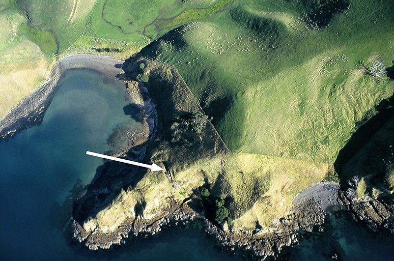
Main defensive
ditch
Fig. 2 Recent aerial view of the Station Bay pä. Note the rocky shore surrounding the site and the small shingle beach (photo:
Kevin Jones).
Fig. 3 The Station Bay pä from the northwest in 1967, showing the principal defensive ditch, the tihi and the sheltered intertidal
platform within the bay at the base of the pä (photo: Janet Davidson).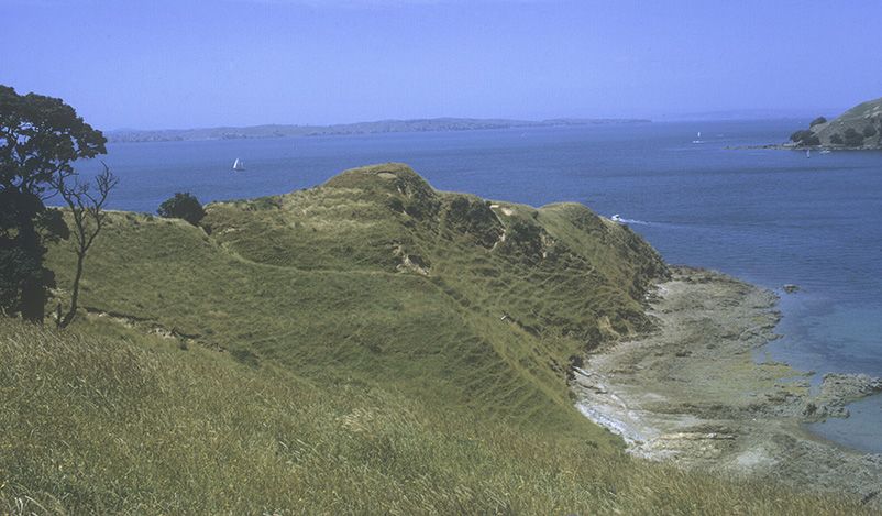
8   Tuhinga, Number 24 (2013)

                                                                    Archaeological research on Motutapu
                                                                 Motutapu has been the scene of considerable archaeological
                                                                 research for more than 50 years. This began with two seasons
                                                                 of excavation at the stratified beach site at Pig Bay (formerly
                                                                 N38/21, now R10/22) in 1958 and 1959 (Brothers &
                                                                 Golson 1959; Golson & Brothers 1959), and was followed
                                                                 by excavation of another stratified coastal site, the Sunde site
                                                                 (N38/24, now R10/25), in 1963 (Scott 1970) (see Fig. 28
                                                                 for locations). In both of these excavations, the volcanic ash
                                                                 erupted from nearby Rangitoto was an important strati-
                                                                 graphic marker. An initial survey of the island was carried
                                                                 out by the Auckland University Archaeological Society early
                                                                 in 1963, resulting in what appeared to be a large number
                                                                 (~70) of sites (Davidson 1970a).
                                                                     The Auckland Institute and Museum (Auckland
                                                                 Museum) research programme on Motutapu began in the
                                                                 summer of 1967–68 with the excavation of two ‘undefended
                                                                 sites’ at Station Bay: the Davidson undefended site (N38/37,
                                                                 now R10/38; Davidson 1970b) and the Leahy undefended
                                                                 site (N38/30, now R10/31; Leahy 1970). These excavations
                                                                 were designed to investigate the nature of the subsurface
                                                                 features that gave rise to the surface evidence found during
                                                                 the site survey and, indeed, to test whether some of the
Fig. 4 The principal defensive ditch looking east in 1967. The   more amorphous surface evidence did actually represent
sheer right-hand wall is immediately adjacent to Area B of the   archaeological features. The next stage of the research was
excavation (photo: Janet Davidson).
                                                                 the excavation of the Station Bay pä and a group of pits
                                                                 outside its defences (Davidson 1972; Sullivan 1972), and
after a place in the homeland of Hawaiki, and was known          further excavation at the Leahy site (Leahy 1972). The
to his descendants as Te Motu Tapu a Taikehu. It was occu-       results were reviewed in a short paper (Davidson 1978c) and
pied until the early nineteenth century by Ngäti Tai, whose      incorporated in a broader review of the wider Auckland
name links back to various ancestors whose names could be        region (Davidson 1978b). The locations of the three
shortened to Tai. The lives of the Ngäti Tai on Motutapu         excavated sites are shown in Fig. 5.
and elsewhere in the vicinity were seriously disrupted by            The aims of these excavations were to investigate the
incursions by Ngä Puhi war parties armed with muskets from       similarities and differences between the pä and the unde-
1821 onwards, although they were able to return to their         fended sites, explore the nature of the defences, and obtain
lands by 1836. They then came under increasing pressure to       information about the layout of the site and its structures,
sell land to Europeans.                                          samples of midden and an artefactual assemblage (Davidson
    In 1840, most of Motutapu was sold by Ngäti Tai leader       1972: 2).
Tara Te Irirangi and others to his son-in-law Thomas                 In the course of the two excavation seasons it became
Maxwell. It was farmed privately, by several successive          apparent that there were still a lot of unrecorded sites on the
owners, until the Second World War, when it was acquired         island. An intensive resurvey was therefore begun in the
by the Crown. At the time of the Auckland Museum research        summer of 1972–73 and finished in 1977 (Davidson 1987).
on the island, it was a Lands and Survey Department farm.        At the same time, an apparent terrace on an undefended site
It became part of the Hauraki Gulf Maritime Park when            at Pig Bay on the island’s northwest coast (N38/140, now
that was established in 1967 and is now administered by the      R10/137) was excavated (Leahy 1986). This marked the
Department of Conservation.                                      end of the Auckland Museum programme on Motutapu.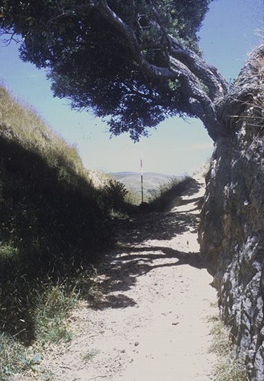
Archaeological excavations at the Station Bay pä, Motutapu Island, inner Hauraki Gulf, New Zealand           9

                                                                                   The excavation
                                                                  The excavation at the Station Bay pä took place between 19
                                                                  December 1970 and 26 January 1971. A varying number of
              A                                                   volunteers participated. A baseline was laid out along the
                                                                  site and excavation units were aligned to it. One square was
                                                                  excavated on the highest point (the tihi, A on Fig. 6) and
     B                                                            four on the relatively large flat immediately inside the north-
                                        Pā                       ern defensive ditch (the central flat, B). Trenches were opened
                            Station                               on the western end of a terrace between the tihi and the
                              Bay                                 central flat (the internal terrace, C) and between the north-
                                                                  ern ditch and the large pit excavated by Sullivan (the exter-
                                                                  nal terrace, D) (Fig. 7).
                                                                      Excavation was by hand trowel, following natural layers.
                                                                  Initially, the upper deposits on the main flat, which con-
                                                                  tained midden shell and bone, were excavated in blocks of
                                                                  1 m2 and sieved through 6.35 mm mesh. However, this
                                                                  proved difficult to manage and the deposits were later bagged
                                                                  variously according to 3 m squares, or specific features and
                                                                  patches within the squares. Sieving was limited to parts of the
                                                                  midden-bearing Layer 2. Shell and bone was retained from
                                                                  the sieving and hand-picked from other deposits. Because
                                                                  of the diffuse nature of the midden and the large amount of
                                                                  fire-cracked stone, only one large bulk sample was taken.
                                                                  This was a sieved sample from a patch of denser compacted
Fig. 5 Aerial view of Station Bay in 1963, showing the pä and
the two previously excavated sites: A, Leahy undefended site,
                                                                  midden at the base of Layer 2 in F4, Area A, which weighed
N38/30; B, Davidson undefended site, N38/37. Note the             a little over 6 kg. Unworked stone was weighed according to
extent of the intertidal rocky shore in the vicinity of the bay   square and layer, and then discarded. These procedures were
(photo: New Zealand Aerial Mapping).                              not unusual at the time, particularly where faunal analysis
                                                                  was not the primary objective.
                                                                      The bedrock was hard clay that had developed on the
    There has been considerable further research on the           underlying greywacke. Cultural layers included redeposited
island since 1977. In 1981–82, Nichol (1988) carried out          material from the digging of pits and other features into the
extensive work at the Sunde site. In 1994, Irwin, on behalf       underlying natural, and dark ashy soil and midden resulting
of the Anthropology Department, University of Auckland,           from occupation.
contracted with the Department of Conservation to provide
a greatly improved database, using geographic information                            Area A: the tihi
systems (GIS) at a feature level to inform conservation           Four 2.5 m squares separated by 1 m baulks were set out on
management during the implementation of the Motutapu              the tihi area, but only one (L4) could be excavated in the
Restoration Plan (Irwin et al. 1996). This led to exploration     time available (Fig. 8). This square had no surface features
of important issues such as site definition and the effects of     apart from a slight depression towards the south side.
splitting and lumping (Doherty 1996). During the course           Beneath the turf was a fairly thick soil layer (up to 25 cm
of the Auckland University programme, six undefended              deep) containing pebbles, other stones, charcoal fragments,
sites were investigated and Turner undertook limited further      minimal amounts of faunal material (including rat bone)
investigations at Pig Bay (Irwin et al. 1996; Szabó 1999;         and numerous small pieces of obsidian. Below this was a
Watson 2004; Ladefoged & Wallace 2010; G.J. Irwin, pers.          hard surface, which was at first thought to be natural, but
comm., 24 August 2012; M.T. Turner, pers. comm., 1995).           was discovered to be the compacted surface of the fills of
Some aspects of this research are discussed below.                three pits that lay only partly within the square.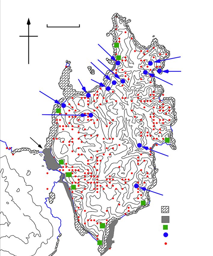
10   Tuhinga, Number 24 (2013)

            E                    B
                                                A
                      D

                                                 C
                                                MN
                                            N

                                                                                 0            20
                                                                                     metres

Fig. 6 Plan of the Station Bay pä, showing the excavated areas.
A–D are described in this paper; E is the group of external pits,
the largest of which was excavated by Sullivan in 1972.

   Pit 1 on the northern side of the square measured more
than 230 × 110 cm in area, with a maximum depth below
surface at its western end of 60 cm. The probable orientation
was east–west. Its western end abutted a shallower feature,
which was either a step down into the pit, or an earlier
truncated feature. The surface of the pit fill included com-
pacted clay lumps to the west and a scatter of pebbles, almost
like a paving, to the east. The fill was undifferentiated rede-      Fig. 7 View from the tihi (Area A) of excavations in progress
posited clay except for a thick burnt layer almost on the bot-      in Area B in January 1971, with Sullivan’s excavation of a large
tom, which petered out over some clay lumps in the west.            external pit in the background beyond the defensive ditch.
                                                                    Square G4 is in the foreground, with F4 beyond it and E4 and
Charcoal from the burnt layer was identified by Jean
                                                                    E5 nearer the pöhutukawa trees growing in the defensive ditch
Goulding of the Auckland Museum (pers. comm., 10 August             (photo: Janet Davidson).
1971) as consisting entirely of bracken fronds – pieces of
stalk (stipes), the midrib of leaflets (rachis) and leaflets
(pinnae). Some of this material was used for a radiocarbon          overlying a softer fill, which contained a thin burnt lens
sample (NZ4349).                                                    towards the bottom. Pit 3, which was of a similar depth to Pit
   Pit 2, of which only a small part was exposed in the south-      2, had an undifferentiated mixed fill. There was a buttress,
west corner of the square, had been truncated by a later pit        asymmetrically placed in the northern wall, closer to the
(3). The fill of Pit 2 consisted of an upper layer of clay lumps,    western than the eastern corner. Between the western corner
Archaeological excavations at the Station Bay pä, Motutapu Island, inner Hauraki Gulf, New Zealand               11

                                                                      or arthrosis. No Harris lines were present. Both showed
                                                                      evidence of tooth wear, including ‘fern root planes’,
                                                                      periapical abscesses and pre-mortem loss of some molars.
                                                                      There was no evidence of violence or trauma in the parts of
                                                                      the skeletons exposed.

                                                                                    Area B: the central flat
                                                                      The flat area immediately inside the northern defensive ditch
                                                                      proved to have been used intensively, initially probably only
                                                                      for pit construction, and later for surface structures and
                                                                      defensive features. At some point between our first season
Fig. 8 Square L4 in Area A, looking east. Pit 1 is on the left, pit
                                                                      at Station Bay in the summer of 1967–68 and the end of
3 on the right, and the vestige of Pit 2 in the bottom right-hand
corner (photo: Janet Davidson).                                       1969, someone, presumably looking for artefacts, dug a
                                                                      trench across this area. Fortunately, this was shallow (and
                                                                      presumably unproductive). It is shown as ‘recent disturbance’
and the buttress was a scooped area of charcoal, apparently           in the sections of F4 in Fig. 9.
a fire feature of some kind. Two human bodies had been                    Three main layers were identified in the four squares
placed together on the floor of the pit, face to face and with         excavated in this area (Fig. 9):
their heads towards the buttress; only the heads, arms and            Layer 1 Topsoil.
most of the torsos lay within the area of the excavation.             Layer 2 Dark, often ashy soil containing fire-cracked stone
   In view of their similar alignment and the presence of             and faunal material, associated with, and often filling, a
burnt bracken near the base of both their fills, pits 1 and 2          large number of postholes of varying sizes.
were probably contemporary. They were abandoned long                  Layer 3 A yellower, more clay-like layer containing small
enough for a little fill to accumulate naturally and bracken to        amounts of faunal material and occasional burnt or ashy
grow, before being deliberately filled to ground level imme-           lenses, associated with, and filling, a number of pits and
diately after the bracken was burnt. Pit 3 was constructed on         postholes.
a slightly different alignment. The bodies were placed on
                                                                      Both Layer 2 and Layer 3 clearly reflected repeated activities,
the floor of the pit, which was then filled to the same level as
                                                                      resulting in intercutting and residual features. Although there
pits 1 and 2. Pebbles were deliberately laid on the surface
                                                                      were variations in the texture of Layer 3, from finer, softer
but there appear to have been no structures substantial
                                                                      material to hard clay lumps, these did not correspond to dif-
enough for posts or stakes to penetrate the pit fills or the
                                                                      ferent feature fills and it was usually difficult or impossible to
remains of the natural surface between the pits. Activities at
                                                                      trace the edges and floors of intercutting features.
this time involved the use and discard of obsidian.
   It is unlikely that Pit 3 was dug as a burial pit. There was       Layer 2 features
no indication during excavation or in the south section of            (Fig. 10)
the square that a grave had been dug through the pit fill. It          Although cooking was apparently a major activity during
appeared that the bodies were placed on the clean floor of             the Layer 2 occupation, reflected by large amounts of char-
the pit before any natural fill had accumulated following              coal and fire-cracked stone, only one definite cooking feature
abandonment. The pit was then deliberately filled. Such a              was identified: a small, shallow oval hollow in the surface of
burial is most unusual, and is further discussed below.               Layer 3 in G4, lined with small stones and covered with
   The two individuals buried in Area A were studied by               charcoal. Ashy patches and lenses were common in E4 and
Houghton (1977), together with two single burials from                E5; some of the better defined examples are shown in Fig. 10.
the two undefended sites in Station Bay. He identified the                Unworked stone in Layer 2, assumed to be debris from
two from the pä as a male of estimated age 30–35 and                  cooking, was weighed according to square as follows: E5,
height 5 ft 6.6 in (1693 mm) and a female of estimated age            96 kg; E4, 68 kg; F4, 70 kg; G4, 10 kg.
28 and height 5 ft 2 in (1576 mm). Cause of death was not                The principal features associated with Layer 2 were post-
apparent and neither individual showed signs of pathology             holes, ranging from very large holes (assumed to be for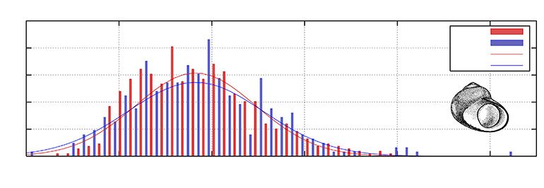
12    Tuhinga, Number 24 (2013)

                                                                West Faces
Datum            G4                                                 F4                                                                 E4

                                                                                                                                               1
             1                                                                1                                                        2
                   2                                                                     2                               3
                           3    Pit 1                                                                                                      Pit 1
               3 3a                                                                                                                    3
                                                                         3                                                            Pit A
                       3                                                                     Pit 1
                           3a
                                                                              3a       3a
                                                                East Faces
Datum             E4                                                     F4                                                           G4

                           1                                1                                                                             1
                  2
        3     3                                                               2                                                       2
                          3                            3                                     3 Pit 4                    3     Pit 2
                       Pit C
                                                           Pit A         3

                                  Recent disturbance                              Oven stones                                   3a
                                         Burnt layer                              Clay lumps
                                                                0                 1m

Fig. 9 East and west sections of squares E4, F4 and G4 in Area B.

                       E                                                 F                                                             G

  4

                                                                              0                 1          2
                                                                                             metres

                                                                                       Shallow feature with concentrated shell fill
  5                                                                                    Depression with ashy fill

                                                                                       Ovens

                                                                                       Posthole

                                                                                       Posthole associated with floor

Fig. 10 Layer 2 features in Area B.
Archaeological excavations at the Station Bay pä, Motutapu Island, inner Hauraki Gulf, New Zealand                       13

                   E                                                      F                                               G
                               C                       A
                                                                                           4                 A

                           1                                          2
                                                                                                                 2

4                 B
                                           2
                                                                                  1
                                                                                                                      1

                  A

                           B                          0              1                2m
        1
                       2                                   Layer 2 fill

                                                           Layer 3 fill

5                                                          Intermediate fill
                                   A
                                                           Deep rectangular post holes

                                       3                         Shallow groove in floor

Fig. 11 Layer 3 features in Area B. In each square, the larger rectangular pits are numbered according to the apparent sequence from
bottom to top, and the smaller pits similarly listed by letter.

palisade posts) in E4 and E5, to tiny stake-holes in all four                 inner edge of ditch, but back behind the bank. Although
squares. Recognising and defining the smaller holes was                        the Station Bay situation is different in that there is no
difficult, and there were probably many more than are                          artificial bank, only a slight natural slope up to the edge of
illustrated. They were identified at different levels within the               the vertically sheer ditch, the position of at least some of
layer and some were capped with clay over a Layer 2 fill. One                  the presumed palisade posts is not unlike the examples
trampled surface associated with several small post- and                      illustrated by Trotter. These South Island examples all date
stake-holes was identified in the southwest corner of E5.                      to the nineteenth century and the period of musket warfare.
Large postholes with Layer 2 fill, which penetrated deep                       No items of European material culture have been found at
into the natural clay, were interpreted as palisade holes.                    the Station Bay pä, but an early nineteenth-century age for
They are clearly marked on Fig. 11, as they were not all                      the final occupation is not impossible.
identified during the excavation of Layer 2.                                   Layer 3 features
    The large holes appear to represent defensive structures set              (Fig. 11)
slightly back from the edge of the ditch. Contrary to expec-                  The majority of features associated with Layer 3 were
tations, the slope upwards towards the ditch in E4 and E5                     rectangular pits; there were also smaller, usually deep, basin-
was found to be the natural slope through which the ditch                     like pits and, in E4 and E5, large postholes that again were
had been dug and not a low inner bank. The large postholes                    assumed to be for defensive structures. The rectangular pits
ranged in depth below surface from about 135 cm to 200 cm.                    are numbered in each square from earliest to latest, except
    Trotter (2009) has recently presented several examples                    that E5/2 and E5/3 share the same alignment and were
from South Island pä in which palisade posts were set not                     probably contemporary. Examples of the complex structures
on the top of the defensive inner bank or the immediately                     uncovered are illustrated in Figs 12–15.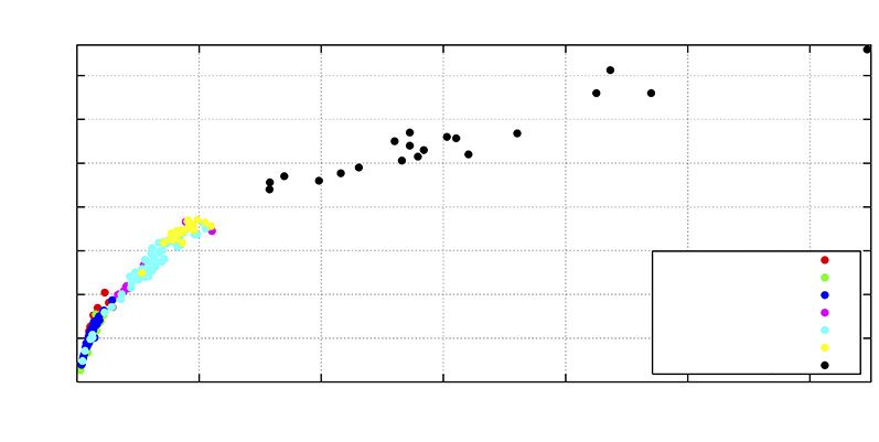
14    Tuhinga, Number 24 (2013)

Fig. 12                                                            Fig. 13

Fig. 14                                                            Fig. 15
Fig. 12 Square E5 looking north. Pits A and B are towards the front. The ranging pole marks a large Layer 3 posthole exposed in
section (photo: Janet Davidson).
Fig. 13 Square E4 looking north. Pits A and B are in the foreground left and centre (photo: Janet Davidson).
Fig. 14 Square F4 looking north. The distinction between Layer 2 and Layer 3 is very clear. Part of one of two large rectangular
postholes is at centre right (see also Fig. 29) (photo: Janet Davidson).
Fig. 15 Square G4 looking north. Part of the very hard fill of Pit A, centre right, remains unexcavated (photo: Janet Davidson).

    No rectangular pits were completely exposed. They varied       found by Sullivan in the floor of her large pit to the north
slightly in orientation and considerably in depth. A few           of the ditch (Sullivan 1972: 32, 40–43), they are deeper
had buttresses; none had floor drains or sumps, despite the         and more rounded. G4/A was not fully excavated. It had an
impermeable nature of the bedrock. Both single and paired          extremely hard fill, similar to that in part of E5/A.
alignments of postholes were identified. Most pits had                 The two largest pits, F4/1 and G4/1, both had multiple
straight sides, but Pit 2 in G4 had sloping sides, and may have    floors; there also appeared to be a third smaller pit within
been functionally different from the others. The marks of          F4/1, visible in the north section, although not detected
digging sticks were visible in the walls of some of the earlier,   during excavation of the Layer 3 fill.
deeper pits, particularly G4/1. The approximate depths                Postholes with Layer 3 fill were mostly either in the floors
below surface of pits not shown in Fig. 9 were as follows:         of pits or very large holes in E4 and E5, and likely to be for
E5/1, 60 cm; E5/2, 80 cm; E5/3, 80 cm; E4/2 60 cm.                 palisade posts. However, two deep rectangular holes in
    The curious oval pit E5/A and the small, deep, rounded         the northeast of F4 (Fig. 29) appeared to represent a quite
rectangular pits E4/A–C and E5/B (Fig. 11) were thought            different kind of structure, perhaps of vertical slabs, of
during excavation to be the earliest features in these squares.    which no further traces were found. This is the only evidence
The oval pit was apparently abandoned unfinished.                   in the excavated area of what might have been a significant
Although the others bear some resemblance to the bin pits          surface building.
Archaeological excavations at the Station Bay pä, Motutapu Island, inner Hauraki Gulf, New Zealand 15
There was some cooking stone in patches in Layer 3.
Stone from Layer 3 in F4 amounted to 37 kg. Stone from
Layer 3 in the other squares was not weighed.
Area C: internal terrace
The internal terrace at the base of the northern slope of the
tihi area overlooks the main flat and the larger terraces above
and below the western arm of the main defensive ditch. No
surface features were apparent. A 3.5 × 2 m trench (J7)1 was
excavated at its western end. It was hoped that the terrace
might prove to have been the site of a house.
The trench revealed part of a well-preserved rectangular
pit (J7/1) aligned along the terrace. It was 180 cm wide by
more than 220 cm long and 70 cm deep, with an end
buttress and a single central posthole in the area exposed. It
appeared to have been cut through a grey and, in places, ashy
soil overlying hard clay bedrock. The grey soil itself was
overlain by a yellower clayey deposit that was probably
derived partly from construction on the terrace and partly
from activities on the tihi above. This in turn was covered
by thin topsoil.
The pit fill consisted of a hard layer of flecked clay at the
bottom, an ashy central layer and an upper layer of hard clay
lumps. The top of this upper fill was level with the point at
which the pit had been cut into the bedrock and had Fig. 16 The external trench in Area D, looking north towards
obviously been open to the air for a while, as there were the scarp leading up to the large external pit. The rectangular
patches of dark soil and a slight hollow containing burnt hole at centre right is a test pit (photo: Janet Davidson).
material in its surface. Above this surface was a thick layer
of soil, flecked with clay in its lower part, presumably partly
derived from activities on Area A above. Eleven small pieces the artificial scarp, which, like the underlying clay layers,
of obsidian and one identifiable fish bone (a snapper maxilla) thinned towards the south. No cultural material was found
were found in this area. in this trench apart from a cluster of fire-cracked stones
equivalent to a basketful, dumped in the fill against the
northern scarp.
Area D: external terrace The purpose of the scarp and dished flat was not clear. If
A 4.8 × 1 m trench was excavated along the baseline between they were the remains of an earlier ditch it would have been
the large external pit investigated by Sullivan and the top of wide and shallow, symbolic rather than an effective defence.
the transverse ditch to the north of the central flat, to see
whether this apparent terrace represented an earlier defensive
The occupation sequence
ditch (Fig. 16). From the northern edge, the trench followed
what appeared to be a natural downward slope for a short The most intensively occupied area uncovered by the
distance. There was then a clearly artificial scarp of about excavations was Area B. A sequence from undefended pits
60 cm leading down to a slightly dished flat about 2 m wide. through defended pits to a final dense occupation deposit
The natural surface then rose gradually again. A lumpy clay without pits inside renewed defences was long ago argued for
fill, thickest at the edge of the scarp, extended across the flat sites such as Ongari Point (particularly the eastern and
and merged into a thinner clay layer capped with lumps. central areas) in the Bay of Plenty (Shawcross 1964, 1966)
These clay layers were overlain by a thick soil deposit against and Waioneke on the southwest of the Kaipara Harbour16 Tuhinga, Number 24 (2013)
(McKinlay 1971), and more recently for Anatere in the any point in the sequence in the other areas before the final
Bay of Plenty (Phillips & Allen 1996). The central flat of the modifications of the tihi.
Station Bay pä repeats this sequence. One of the aims of the excavation was to establish the
The Layer 3 features clearly include several different relationship between the three large pits visible on the surface
episodes of pit construction. Patches of burning within the of the ridge outside the pä to the north and the pä itself.
layer appear to indicate periods of at least brief abandon- It seems most likely that the external pits pre-date the con-
ment, for example the burning of vegetation that had grown struction of the pä. Pits F4/1 and G4/1 are the earliest in their
in pits abandoned long enough for some fill to accumulate, respective squares and the largest uncovered in Area B,
or on surfaces that were subsequently covered with spoil comparable in size to the external pits. They could therefore
from renewed pit digging activity. Several such lenses can be easily belong to a period of undefended pit construction over
seen in the west faces of the Area B squares (Fig. 9). the wider area of the headland, which Sullivan (1972: 60)
The abundance of small postholes associated with Layer described as ‘extensive’, rather than ‘constricted, concentrated
2 suggests a number of relatively flimsy buildings and/or and intensive’. In support of this view, Sullivan also identified
racks, again constructed on a number of occasions, but there what she considered spoil from ditch construction in the
is no evidence of substantial buildings other than the two fill of her large external pit after its main use had ceased
large rectangular postholes in F4 (Figs 14 and 29). The main (1972: 48, 59).
large structures appear to be defences. Repeated brief occu- Although the large external pit was never completely
pations, rather than any sustained or permanent occupation, filled in, a smaller adjacent pit was. This feature (Pit E) was
are indicated. rectangular, with an end buttress, and was comparable to the
As some of the large postholes in the central area have pit in Area C. Sullivan considered Pit E to be contemporary
Layer 3 or ‘intermediate’ fills, it seems likely that the later, with the use of the large pit and argued that it was delib-
mostly smaller, rectangular pits in the central area were erately filled to provide a subsequently well-used path along
constructed inside what had now become a defended site. the east edge of the ridge to the pä. She also identified the
The large postholes in E4 and E5 appear to represent several earliest feature in the area she investigated as a probable
phases of construction of a palisade and perhaps (in E5) a small terrace (Structure W) just to the southwest of her
fighting stage. large pit, arguing that it pre-dated the large pit by a definite
It is impossible to estimate the number of separate time gap (Sullivan 1972: 33). This small terrace is not shown
construction episodes. Some may have been minor and local. on the site plan.
For example, pits E5/2 and E5/3 are on a similar alignment A sequence can therefore be suggested as follows:
and may therefore have been constructed at the same time,
1. Initial use of the area represented only by Structure W,
but whereas E5/2 was apparently deliberately filled imme-
probably a small living terrace.
diately after use, E5/3 had a very weathered floor, which
2. Use of the ridge top, both inside and outside what would
must have been left open to the elements after the super-
become the pä area, for the construction of kümara
structure was demolished or removed.
(sweet potato, Ipomoea batatas) storage pits, both large
By contrast, there appear to have been only three stages
and small rectangular pits, and smaller ovoid and
of occupation of Area A: two phases of pit-building and a
rounded rectangular pits.
final occupation without pits, midden or, in the single square
3. Initial ditch construction with continued construction of
excavated, structures. Area C had only two clear stages:
mainly smaller pits.
terrace and pit construction, followed by pit-filling and
4. Final refortification without pits, at least in the areas
transient use of the new surface.
excavated.
It is not easy to correlate the three areas excavated inside
the pä. Area A can be argued to share at least part of the This sequence depends on the assumptions that the earliest
sequence in Area B, with two phases of pit construction pits inside the pä were probably roughly contemporary with
followed by a flat working area of some kind with no pits. the pits outside, and that use of the pä area continued after
Area C, with one pit, very limited signs of later occupation the latter were abandoned. The presumed Layer 3 palisade
in the excavated area and later slope debris derived from holes in squares E4 and E5 are very close indeed to the
activities further up could be a still paler reflection of part early pits in those squares and in some cases are dug partly
of this sequence, but equally could stand alone, relating to through their fill. Fortification of the Layer 3 pits insideArchaeological excavations at the Station Bay pä, Motutapu Island, inner Hauraki Gulf, New Zealand 17
Table 1 Radiocarbon dates for the three excavated sites at Station Bay.
Site Lab# Context Material δ13C CRA
Pä NZ4349 Burnt bracken in pit, Area A Charcoal –23.6 ± 0.1 35 ± 66
WK35391 Midden at base of L2, Area B Shell 0.9 ± 0.2 630 ± 30
NZ8128 Fire feature in external pit, Area D Charcoal –27.3 377 ± 41
NZ4348 Burial, Area A Human bone –25.0 ± 0.1 367 ± 41
WK35392 Burnt bracken on surface within L3, Area B Charcoal –23.8 ± 0.2 442 ± 25
Leahy site NZ8129 Pit 2 Charcoal –26.0 323 ± 35
NZ4347 Burial Human bone –18.2 ± 0.1 630 ± 30
Davidson site NZ1168 Hängï 1 Charcoal –27.0 189 ± 86
NZ4346 Burial Human bone –15.0 ± 0.1 451 ± 45
the pä would have been possible only if the ambiguous intercepts on the calibration curves make interpretation
feature in Area D was, in fact, an earlier ditch. difficult. It has also become apparent that on Motutapu,
It is tempting to consider that the various burnt surfaces charcoal from immediately beneath the Rangitoto ash can
in Areas A, B and D represent a site-wide event – either a readily be incorporated into cultural deposits.
landscape fire when the site was unoccupied, or a deliberate Nine radiocarbon dates for the three Station Bay sites
fire on the site in preparation for reoccupation. This could have previously been published (Davidson 1972: 5–6;
assist in linking the various areas and establishing a chrono- 1978a: 15). Three of the published dates from the Davidson
logy. On balance, however, it seems unlikely. The fire feature undefended site were from non-cultural contexts beneath
in Area E was interpreted by Sullivan (1972: 43–46) as a the Rangitoto ash. One from an apparent cultural context
deliberate fire, localised within the pit, fairly soon after it fell (NZ1164) was of similar age; this sample is assumed to have
into disuse. The burnt bracken in the partly filled pits in Area been pre-ash charcoal redeposited in pit fill. A further
A was probably the result of deliberate burning some time previously unpublished charcoal date, NZ8130, returned a
after the pits had been abandoned. The various burnt patches conventional radiocarbon age (CRA) result of 656 ± 31 BP
in Layer 3 in Area B were small and localised, and unlikely (δ13C-27.4) and was evidently also pre-ash charcoal. These
to be connected to each other or to fires in other areas. dates are not considered further here.
Although information was collected about structures, The remaining five published dates and four additional
faunal remains and material culture for comparison with the ones are listed in Table 1. Slight differences between Table
Station Bay undefended sites and sites elsewhere on the 1 and previously published results are due to recalculation
island, little was learnt about the fortifications, or about at the Rafter Radiocarbon Laboratory. The age ranges
how the site actually functioned as a fortified pä. The corrected for marine reservoir and secular effects in years Cal
northern ditch, with its sheer walls backed by substantial
BP are presented in Fig. 17.
palisading, was clearly a serious defensive device, requiring
Houghton (1977: 40) used nitrogen levels in the bones
considerable labour to construct. How it related to the
of the burials from Station Bay to estimate the site ages as
terraces above and below it, and to the southern ditch, could
follows: Leahy site, AD 1400; Davidson site, late 1700s; and
not be established in the time available.
the pä, early 1700s. The burials provided the samples for the
radiocarbon dates NZ4346, NZ4347 and NZ4348. The
Chronology human bone dates are consistently earlier than the charcoal
Radiocarbon dates from Station Bay provide a good example dates from similar contexts; in the case of the pä, the burial
of why radiocarbon dating is often not very helpful in estab- is thought to be stratigraphically more recent than the
lishing a clear chronology for pre-European sites in New bracken sample (NZ4349) from the adjacent pit in Area A.
Zealand. The extent of the probability ranges and multiple The possibility that a major contribution of seafood to the18 Tuhinga, Number 24 (2013)
8.2% 18.3% 9.0% 32.7%
NZ4349 17.5% 77.6%
68.2%
WK35391 95.4%
54.0% 14.0%
NZ8128 95.0%
68.4%
NZ4348 95.1%
68.2%
WK35392 83.0% 12.4%
Station Bay Pā
32.0% 37.0%
NZ8129 46.0% 43.0% 2.0% 2.0%
67.5%
NZ4347 6.2% 88.7%
Leahy Undefended Site
42.4% 16.9% 8.7%
NZ1168 1.4% 93.6%
59.2% 9.0%
NZ4346 68.7% 26.3%
Davidson Undefended Site
1300 1400 1500 1600 1700 1800 1900 2000
Calibrated Radiocarbon Age AD
Fig. 17 Radiocarbon dates from the three Station Bay sites in years Cal AD after secular correction and calibration by the laboratories
using southern hemisphere atmospheric data from McCormac et al. (2004) and, for the shell sample, marine data from Reimer et
al. (2009). Yellow, charcoal dates; red, human bone dates; blue, shell date.
diet of these people has influenced the bone dates does not Bone and shell items
appear to be supported by the δ13 C values.
Worked bone was examined by Ian Smith and Sheryl
The results suggest that the site on the headland,
McPherson but in most cases the material could not be
including the external pits as well as the pä, was periodically
occupied over a period of up to three centuries, with the final determined.
occupation probably close to the end of the eighteenth Two points of composite fishhooks are round-sectioned
century or early in the nineteenth century. Of the two pieces of bone with minimal modification. One, from E5,
undefended sites, the Leahy site is earlier, perhaps close to Layer 3, has a slight but definite barb (Fig. 18C). The foot
the initial use of the headland for pits, and the Davidson site, and lashing ridges seem to suggest that the barb was intended
in its final use at least, is later, perhaps close to the final to be on the outer surface, but the base may have been
occupation of the pä. damaged and repaired to produce this unusual effect. The
material is possibly moa bone. The other point, from
G4, Layer 2 (Fig. 18B), is smaller and simpler with no
Material culture barb, a clearly defined face for attachment to the shank,
Very few items of material culture were recovered from the and five tiny grooves to assist lashing. The material is possibly
excavations. A stone adze and a small selection of worked whale bone.
bone and shell came from Area B. Most items were from Two pieces of worked shell that may be parts of fishhooks
Layer 2 but some were from Layer 3 or from the sometimes were found in the bulk faunal sample from F4, Layer 2. A
confused junction between the two. Obsidian was quite worked piece of what appears to be Cook’s turban Cookia
differently distributed, as described below. sulcata shell with a single tiny notch at one end is probablyArchaeological excavations at the Station Bay pä, Motutapu Island, inner Hauraki Gulf, New Zealand 19
D
A 0 50
C E mm
G
B F H
I
Fig. 18 Bone artefacts and worked bone. See text for contexts and descriptions.
worked dog jaws were found at Taylor’s Hill (Leahy 1991:
A B
54). A puzzling small fragment of a well-made bone object of
some kind from Layer 2 in G4 is possibly whale bone
(Fig. 18H). A tilly bone from Layer 3 in G4, probably from
a snapper, appears to have been slightly modified. A frag-
ment of a long bone shaft, probably dog bone, from the fill
of a Layer 2 posthole in F4 has been sawn transversely.
0 50 Worked shell includes a pipi (Paphies australis) valve with
mm a central perforation from E5 (Fig. 19B), and a dog cockle
(Glycymeris) shell from Layer 2 in F4, chipped all round
Fig. 19 Worked shell. See text for details. the edges (Fig. 19A). Nichol (1988: 392, fig. 9.13E) figures
a fragment of a similarly chipped shell, which he describes
as a scraper, from the Sunde site. However, Furey (1986) has
part of the shank of a baited hook. A flat tapering piece of described pendants made from dog cockle shells from a
green mussel shell (Perna canaliculus) with a slight knob at variety of North Island locations and it is possible that the
the end could be from a trolling lure shank, or could be part Station Bay shell was the first stage of pendant preparation.
of a pendant.
A complete needle (Fig. 18E) came from Layer 1 in G4,
Stone tools
and what is probably the point of another from Layer 2 in E4
(Fig. 18D). The complete needle is slightly curved, following The sole stone adze blade, from Layer 2 in F4, is a small,
the shape of the original bone. It has a drilled hole with what untanged, typically ‘Classic Mäori’ adze, in a fine-grained
appears to be an attempt at another hole partly drilled just black stone (Fig. 20). All surfaces, including the poll, are well
above it on the convex back surface. An item from Layer 2 in ground. It is heavily chipped along about two-thirds of the
E4 is just a rounded piece of bone tapering to a fine point cutting edge and may have been deemed not worth repairing.
(Fig. 18F). The other end is blunt and the item appears to be Similar small adze blades were found at Oruarangi, for
complete. Its function is uncertain. instance, although those examples had a clearly defined bevel
The only object relating to adornment is a small tattooing shoulder (Furey 1996: 108, 110). This adze is different from
chisel (Fig. 18I) from Layer 2 in F4. It has 11 uneven teeth. the adzes found in the two undefended sites in Station Bay
A broken piece of bone, possibly moa, worked to a square (Davidson 1970b: 49; Leahy 1970: 69, 71).
section (Fig. 18A) came from E5, Layer 3, the same context Also from F4, but from the Layer 3 fill at the base of Pit
as the fishhook point that was also identified as possibly moa 3, was a höanga (grinding stone) of fairly coarse sandstone.
bone. Two examples of cut dog mandibles, one of which is It is roughly rectangular, 60 × 65 cm, with a maximum
illustrated in Fig. 18G, were found in Layer 2 in F4 and G4. thickness of 22 cm. Two edges are flat and rough, while the
They are presumably by-products of the manufacture of other two are tapered. One flat surface and one tapered
needles or fishhook points. Elsewhere in the Auckland area, edge appear to have been particularly used as abraders.20 Tuhinga, Number 24 (2013)
number of other artefacts described above, which all came
from Area B. More than 70% of the obsidian pieces came
from Area A: 115 from Layer 2 and seven from the pit fills.
There are 11 pieces from the otherwise largely sterile soil
above the infilled pit in Area C. Within Area B, most of the
obsidian came from G4: 13 pieces from just under the top-
soil, nine from Layer 2 and seven from Layer 3. In contrast,
there were only 10 pieces from all layers in E4, E5 and F4
combined. It appears that obsidian is largely associated with
0 50
areas where there is little or no midden. It is possible that
mm
some tiny chips of obsidian escaped notice during excavation
Fig. 20 Stone adze blade from Square F4, Layer 2.
of the midden deposits in Area B, but this should not be
enough to alter the overall picture of the distribution.
The obsidian assemblage largely consists of detritus or
A smooth round pebble weighing 442 g from Layer 3 in
chunks, much of which would have resulted from chipping
G4 is possibly an autoru, or stone for grinding kököwai
larger pieces and discarding scraps, but there are also larger
(iron oxide), although there are now no obvious traces of
pieces that show signs of use. Every piece, regardless of
pigment on it. The largest flat surface is faintly dished and
size, was examined under low-power binocular microscope
abraded.
for signs of use-wear and secondary working. Experimental
Two pieces of beach cobbles, found in Layer 2 in F4,
research (e.g. Egeland 2003) has shown that even a tiny
appear to show opportunistic use. One is a flake-like spall,
possibly used as a rough scraper. The other is a significant piece of obsidian or chert is very effective in butchering a
part of an oval cobble, one end of which, forming a natural large animal, since the edges can be extremely sharp, easily
bevel, appears to have been used as a rough, probably hand- severing sinews and removing joints of meat. However, the
held, chopper. A similar object from R10/497, a more paucity of obsidian in Area B suggests it was not being used
recently excavated undefended site on Motutapu, was in this way.
described by Watson (2004: 100) as a heavy pounder or Although obsidian can be fashioned into such sharp tools
hammer stone. or used simply as a flake, it is very brittle, so it is best suited
A number of other chips, spalls and fractured pieces of to cutting and scraping softer materials. It can be used for
greywacke, collected during the excavation, appear to have working wood, bone and shell, but acute-angled edges do
been broken accidentally and left unused. There is no sign not last long, and steep angles are more effective. It is
of the deliberate flaking of local greywacke and chert, as therefore not surprising that amongst the obsidian collection
was seen in the two undefended sites, particularly the Leahy quite a few steep-angled tools were found. The term ‘tool’
site, where 868 flakes were recovered from the small area is used here not in the formal sense of a specific shape being
excavated during the first season (Leahy 1970: 74). However, manufactured before use, but in the sense that a piece of
only one greywacke flake was found during the subsequent obsidian was used as a tool, taking advantage of high-angled
excavation (Leahy 1972: 20), showing that a flaking area edges. There are also some tools in the collection with more
can be very localised within a site. The absence of grey- acute-angled edges. Some of these show use marks along
wacke flakes from the excavated areas does not necessarily concave edges, and qualify as notch-scrapers, sometimes
mean that this kind of activity was not carried out anywhere referred to as spokeshaves. Some of the more notable tools
on the pä. are described below:
Area A, Layer 2
Obsidian items AR3598.41 This small tool shows bi-directional micro-
One hundred and seventy-one pieces of obsidian were flaking along a nose-shaped part of a chunk-shaped piece.
recovered from the excavation. Many are tiny chips and there Such use-wear results from rotating a tool backwards and
are few large items. The distribution of obsidian is very forwards by hand while drilling a hole. The tool could have
different from that of faunal remains or, indeed, the small been used to ream out a hole in a piece of shell.Archaeological excavations at the Station Bay pä, Motutapu Island, inner Hauraki Gulf, New Zealand 21
AR3598.34 This small flake terminates in a hinge fracture been used that has two 90° edges, both of which show
with a 15° cutting edge to the front surface. Along this edge considerable use-wear in the form of micro-flaking. This is
there is extremely fine micro-flaking. It was probably used also a scraping tool.
as a small knife. AR3590a (Square G4) This is best described as a chunk
AR3596.20 A tiny flake with a cutting edge of about 5° rather than a flake. One snapped edge has micro-flaking
angle showing extremely fine micro-flaking. It was probably along one of the 60° edges. This could be a knife for some
used as a small knife. harder material such as wood.
Area A, Layer 3
AR3597a This is one of the largest pieces of obsidian: Discussion
55 mm wide, 22 mm long and 6 mm thick. It is a wide, This small artefact assemblage is compatible with assem-
short flake with cortex on the outer surface. The flake blages from other Mäori sites in the northern North Island
terminates in a hinge fracture. The top of the flake, where that date to the middle and late parts of the prehistoric
the bulb of percussion would have been, has been snapped sequence. Activities on the site probably included fibre-
off. This snapped edge has one sharper edge of about 20° working, limited woodworking, and the repair and
angle and is 35 mm long. There is very fine micro-flaking maintenance of tools, as well as food processing and, at least
along this edge, suggesting use as a knife on some relatively occasionally, tattooing. However, the small size of the
soft material. assemblage could imply brief periods of occupation, rather
than more settled residence. The possible use of artefacts
Area C
made from moa and whale bone is intriguing and may
AR3594e A flake that has been snapped into more than
suggest links to the Pig Bay site, where such items were
two pieces. The original flake terminates in a hinge fracture.
found (Davidson 1978b: 11),
One of the two snapped faces has two 90° edges, and both
of these show considerable use-wear in the form of micro-
flaking. Given the high angle of the edges, a scraping
function is suggested, such as scutching flax or scraping
Faunal remains
wood. The main objective in studying the faunal remains was to
document the shellfish, fish, bird and mammal foods of the
Area B, Layers 1 and 2 occupants of the site and to explore variability within and
AR3588d (Square G4) This small flake has acute-angled between the two main layers in Area B. The great bulk of
edges on both sides, and each displays pronounced micro- protein food came from marine environments, and it is
flaking. Most of the chipping is unidirectional. This type of therefore worth considering what these might have been.
use-wear results from a scraping action. The flake would Allo, who studied the faunal remains from the two
have been used on a harder material, perhaps bone or wood. undefended sites at Station Bay, described five types of
AR3574 (Square E5) This small flake has been broken or marine environment: 1, the Station Bay beach, which at
flaked at the striking platform end, leaving a concave edge that time (late 1960s) was stony and exposed to wave action
that is covered in unidirectional micro-flaking. It has been (Fig. 21); 2, the rocky headlands at either end of the beach
used as a small spokeshave on some round-sectioned object and along the adjacent coastline; 3, the sheltered and rather
such as a spear handle. muddy beaches on the east and southeast of the island, a rich
source of bivalves such as pipi and cockle (Austrovenus
AR3571 (Square E4) This is a small chunk with a nose-
stutchburyi );2 4, the more exposed sandy beaches in the
shaped edge at one end. There is unidirectional micro-
north of the island, where she believed tuatua (Paphies
flaking along this edge. This type of use-wear results from
subtriangulata) could be found; and 5, the offshore fishing
scraping in a groove. The tool could have been used during
ground (Allo 1970: 83).
woodcarving.
In February 2012, Hayward & Morley (2012) carried out
Area B, Layer 3 a survey of intertidal biota at Station Bay. They reported 113
AR3592 (Square G4) This is very similar to item AR3594e species of mollusc and eight species of echinoderms, as well
from Area C, described above, in that a snapped flake has as other invertebrates, listing them as abundant, common,22 Tuhinga, Number 24 (2013)
Fig. 21 The Station Bay beach in January 1968, with the pä in the background (photo: Janet Davidson).
frequent, occasional, rare or dead specimens only. The analysed material checked and mostly rebagged. Bivalves
similarities and differences between their survey and the were sorted according to side and all complete hinges
contents of the midden are discussed below. counted. A decision was taken at the start to count the
Midden deposits in the Station Bay pä were largely umbo of gastropods; in hindsight that was unwise, as some
confined to Area B. Six identifiable fish bones (snapper and species proved more easily identifiable from the aperture.
elasmobranch) were recovered from Area A. A few very Rarer species, usually represented only by other fragments,
weathered pieces of shell from the same context amounted were noted as present and given a minimum number of
to about seven pipi, four cat’s eyes (Lunella smaragdus), and individuals (MNI) value of 1 in each sample in which they
a few possible fragments of mussel (Perna/Mytilus) and päua were present. Species such as scallops (Pecten novaezelandiae)
(Haliotis spp.). A single identifiable fish bone was found in and päua may therefore be overrepresented, while some
Area C, and there was no faunal material in Area D. gastropods, notably Diloma spp. and Cominella spp., are
The deposits in Area B were different from the more underrepresented. However, in the overall scheme of things,
concentrated shell middens, consisting largely of cockles, these differences are unlikely to be important.
found on the volcanic cones of Auckland such as Maungarei Fish bones extracted during the first sorting in the 1970s
(Mt Wellington) (Davidson 2011: 62). At the Station were identified by Leach according to his established
Bay pä, faunal remains were scattered through the soil, methodology (Leach 1986) and included in his reviews of
with concentrations in occasional patches and in the fills of pre-European Mäori fishing (Leach & Boocock 1993; Leach
some features. 2006). The remaining fish bones were identified by the
same procedure in 2011, using the comparative collection in
the Archaeozoology Laboratory at the Museum of New
Methodology Zealand Te Papa Tongarewa (Te Papa). The combined data
About half the material was processed in Auckland in the sets are presented here.
early 1970s. In 2012, the remainder (the remaining part of Bird and mammal bones were identified by Ian Smith
Square F4 and all of E5) was sorted and the previously and Sheryl McPherson (see Appendix 1).Archaeological excavations at the Station Bay pä, Motutapu Island, inner Hauraki Gulf, New Zealand 23
Shellfish Table 2 Relative abundance of shells in the bulk sample AM448
from Station Bay pä.
The relatively large bulk sample from near the base of Layer
2 in Square F4 (AM448) provided the starting point for the
present study (Table 2). This yielded most of the species Taxon Element No. MNI %
represented in the deposits on the site and was large enough Lunella smaragdus Umbo 577
to give an indication of relative abundance. It was apparent Operculum 744 744 36.7
that the occupants of the pä were gathering shellfish from the Austrovenus stutchburyi L valve 532 532 26.2
nearby rocky shore but also from both protected, and to a R valve 489
lesser extent open, beaches (in the terms of Morton & Miller Mytilus edulis L valve 145
1968: 445). The bulk sample also contained some fish bones galloprovincialis R valve 134
and otoliths, discussed below, and 151 g of small pieces of Perna canaliculus L valve 23
R valve 23
unworked stone.
Perna/Mytilus spp. L valve 10
Table 3 compares the relative abundance of all shells
R valve 8
recovered from the midden with their relative abundance in
Total mussel L valve 178 8.8
the bulk sample AM448 and their representation in the
survey by Hayward & Morley (2012). Diloma aethiops Umbo 139 139 6.5
In several cases, specimens of one genus from similar Nerita (Lisanerita) Umbo 72 72 3.6
melanotragus
habitat have not been identified to species. Thus limpets of
the genus Cellana probably include both C. radians Protothaca crassicosta L valve 54 54 2.7
R valve 45
and C. ornata; the thaids of the genus Cominella include
Paphies australis L valve 35
C. maculosa, C. virgata and probably a few examples of
R valve 37 37 1.8
C. adspersa; the topshells of the genus Diloma are predomi-
Gari stangeri L valve 34
nantly D. aethiops but probably also include D. arida. All R valve 37 37 1.8
of these molluscs are likely to have been collected from
Cominella spp. Umbo 9 9You can also read