The Geological Heritage of County Laois - Laois County Council
←
→
Page content transcription
If your browser does not render page correctly, please read the page content below

The Geological Heritage
of County Laois
An audit of County Geological Sites
in County Laois
by Matthew Parkes Ronan Hennessy, Robert Meehan, Vincent Gallagher
and Sarah Gatley

2016

         The County Laois Geological Heritage Project was supported by

       This report is an action of the County Laois Heritage Plan 2014 – 2019

                                         1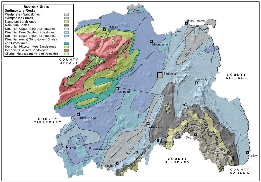
For the:
Geoheritage Programme
Geological Survey Ireland
Beggars Bush
Haddington Road
Dublin 4
01-6782837

and

Catherine Casey
Heritage Officer
Laois County Council
Aras an Chontae
Portlaoise
Co. Laois
tel. 057 866 4129
email. ccasey@laoiscoco.ie

                             2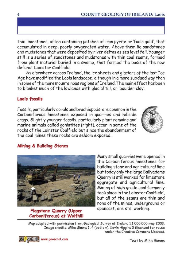
Contents
Section 1 – Main Report
Executive Summary        …………………………………………..…………………..….…..... 5

1. Laois in the context of Irish Geological Heritage   ………………………………….…                  6
      1.1 Laois County Geological Sites           ……………………………………….….…                   8
      1.2 Rejected sites …………………………………..……..………………..….….....                            9
2. Laois Council policies regarding geological heritage …………………………………..                13
3. Geological conservation issues and site management         ……………………….....           15
      3.1 A note on esker conservation in County Laois …………………………….….                  18
4. Summary and Recommendations            …………………………………………..….……..                     19
      4.1 Proposals for promotion of geological heritage in County Laois …………....      20
      4.2 Ideas for projects      .……………………………………………….…………..…                          24
5. A summary of the geology of County Laois          …………………………..………...……              27
6. Acknowledgements          …………………………………………………………..…….…..                            32

Appendix 1 Geological heritage audits and the planning process …………………….... 33
Appendix 2 Bibliography – Geology of County Laois          ………...……….….…….        35
Appendix 3 Bibliography – County Laois Quaternary References    …..…….........….. 42
Appendix 4 Geological heritage versus geological hazards      ……………………..…         47
Appendix 5 Data sources on the geology of County Laois           ……………….....      48
Appendix 6 Further sources of information and contacts ………………...………..…… 50
Appendix 7 Geoschol leaflet on the geology of County Laois ……………………....…          51
Appendix 8 Glossary of geological terms       ……….……………...……..…...……..… 55

Figures
Figure 1. Boley Pit
Figure 2. Killeany Pit II
Figure 3. Biddy Aghaboe’s Well.
Figure 4. River Barrow, Athy to Carlow
Figure 5. New Rossmore
Figure 6. Ross Flagstone Quarry
Figure 7. Trooper’s Quarry
Figure 8. Cover of The Geology of Laois and Offaly
Figure 9. Covers of various county popular style books
Figure 10 Simplified Geological Map of County Laois with County Geological Site locations
indicated, also outlining the main geological units.
Figure11. The Geological Timescale and County Laois
Figure 12. A detailed geological map of County Laois.

                                            3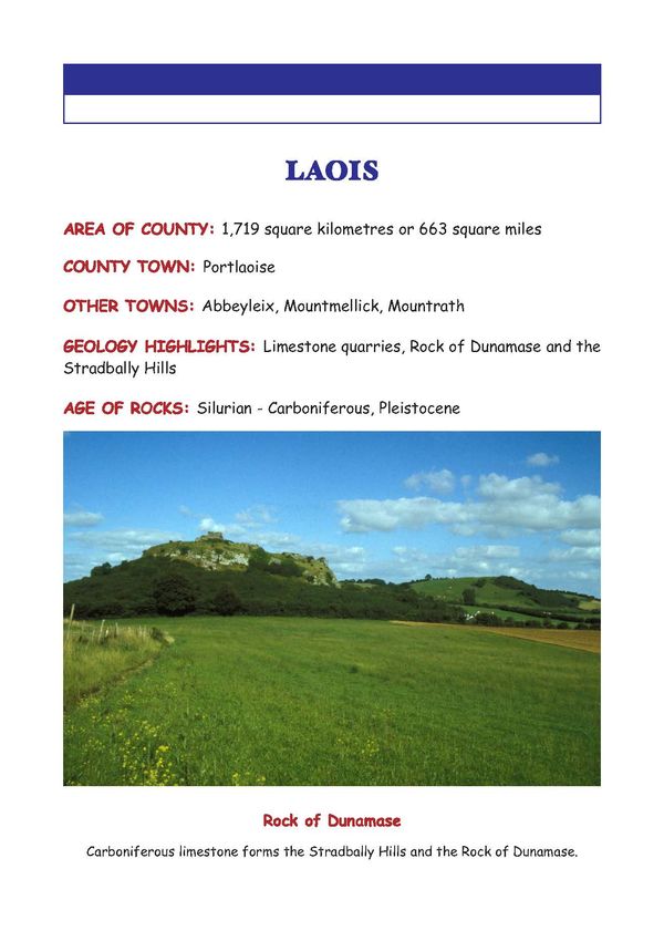
Section 2 – Site Reports
Site reports – general points

            Abbeyleix Bog
            Arless Quarry
            Ballyadams Quarry
            Baunreagh Quarry
            Carroll’s Quarry
            Castlecomer Borehole – Swan
            Clogh River
            Clonaslee Eskers
            Clopook Cave
            Darkin Well
            Farnans Quarry
            Flemings Fireclay Quarries
            Glebe Quarry
            Glenbarrow
            Hollymount
            Killeany Quarry
            Killeshin Glen
            Kyle Spring
            Lisduff Quarry
            Luggacurren Fireclay Pit
            Luggacurren Stream Section
            M7 Road Cut Derryvorrigan
            M8 Road Cut Addergoole
            Modubeagh
            Moyadd Stream
            Old Rossmore
            Poulastore
            Rathleague Spring
            Ridge of Portlaoise
            Rock of Cashel
            Rock of Dunamase
            Sluggory Cross Roads
            Timahoe Esker

                                          4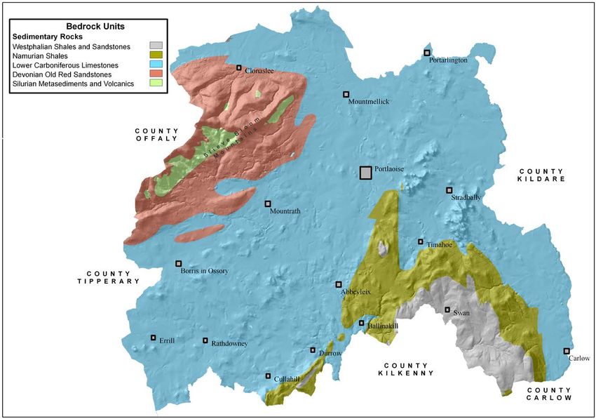
Executive Summary
County Laois is not widely known for its geological heritage. However, it has some fine but
underappreciated geological sites. This report documents what are currently understood by
the Irish Geological Heritage Programme (IGH) of the Geological Survey of Ireland (GSI) to
be the most important geological sites within County Laois. It documents them as County
Geological Sites (CGS), for inclusion within the County Development Plan (CDP). This audit
provides a detailed study of sites to replace a provisional listing based on desk study which
was adopted in the current 2011-2017 CDP, along with strong policies to protect it and
enhance access where feasible.

Some 33 County Geological Sites are documented, including photographs and site
boundary maps that delimit the extent of the geological heritage interest. Additional data in
GIS format are supplied to the County Council to complement the report. The commission
of this audit places County Laois at the current focus of geological conservation in Ireland.
This report is written in non-technical language for use by the Heritage Officer and the
Planning department of Laois County Council. A chapter of the report includes
recommendations on how to best present and promote the geological heritage of County
Laois to the people of the county. It will also inform the work of the IGH Programme and be
made available through the GSI website.

                                             5
1. Laois in the context of Irish Geological Heritage
This report ensures County Laois remains active at the forefront of geological heritage
within Ireland, as a majority of counties have now commissioned such an audit within the
scope of the county-based Heritage Plan. By providing reliable data in a very cost-effective
manner, it will hopefully encourage the remaining local authorities to follow what is now a
tried and trusted methodology. In the absence of significant political and economic
resources available at a national level to the relevant bodies for conservation of geological
heritage as Natural Heritage Areas (NHA), it represents a significant level of progress in
defining and safeguarding Ireland’s geological heritage. In essence, County Geological Site
audits are the only effective geological conservation at present, but only with advisory
capacity (within the context of County Development Plans) and no real statutory protection
where it is required.

It also represents a significant commitment on the part of the Local Authority to fulfil its
obligations to incorporate geology into the spectrum of responsibilities under the Heritage
Act 1995, the Planning and Development Act 2000, Planning and Development Regulations
2001, and the Wildlife (Amendment) Act 2000 and the National Heritage Plan 2002. GSI
views partnerships with the local authorities, exemplified by this report, as a very important
element of its strategy on geological heritage (see Appendix 1).

The Irish Geological Heritage Programme (IGH) in GSI complements other nature
conservation efforts of the last decade, by assessing Ireland’s geodiversity. Geodiversity is
the foundation of the biodiversity addressed under European Directives on habitats and
species by the designations of Special Areas of Conservation (SAC) and more recently on
a national scale by the introduction of Natural Heritage Areas (NHA) as the national nature
conservation method. As a targeted conservation measure to protect the very best of Irish
geology and geomorphology the IGH Programme fills a void which has existed since the
abandonment of the Areas of Scientific Interest scheme, listed by An Foras Forbartha in
1981.

The IGH Programme does this by identifying and selecting the most important geological
sites nationally for designation as NHAs. It looks at the entire spectrum within Irish geology
and geomorphology under 16 different themes:

 1.    Karst
 2.    Precambrian to Devonian Palaeontology
 3.    Carboniferous to Pliocene Palaeontology
 4.    Cambrian-Silurian
 5.    Precambrian
 6.    Mineralogy
 7.    Quaternary
 8.    Lower Carboniferous
 9.    Upper Carboniferous and Permian
 10.   Devonian
 11.   Igneous intrusions
 12.   Mesozoic and Cenozoic
 13.   Coastal geomorphology
 14.   Fluvial and lacustrine geomorphology
 15.   Economic geology
 16.   Hydrogeology

                                                 6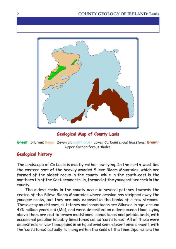
A fundamental approach is that only the minimum number of sites necessary to
demonstrate the particular geological theme is selected. This means that the first criterion is
to identify the best national representative example of each feature or major sequence, and
the second is to identify any unique or exceptional sites. The third criterion, identifying any
sites of International importance, is nearly always covered by the other two.

Designation of geological NHAs will be by the GSI’s partners in the Programme, the
National Parks and Wildlife Service (NPWS). Once designated, any geological NHAs will be
subject to normal statutory process within the County Laois Planning Department and other
relevant divisions. However, compared to many ecological sites, management issues
for geological sites are generally fewer and somewhat different in nature. The
subsequent section considers these issues.

From a national perspective, as a result of extensive comparison of similar sites to establish
the best among them, there is now a good knowledge of many other sites, which are not
the chosen best example, but which may still be of national importance. Others may be of
more local importance or of particular value as educational sites or as a public amenity. All
these various important sites are proposed for County Geological Site (CGS) listing in the
County Development Plan.

Currently, in 2016, a Master List of candidate CGS and NHA sites is being used in GSI,
originally compiled with the help of Expert Panels for all the 16 IGH themes. For several
themes, the entire process has been largely completed and detailed site reports and
boundary surveys have been done along with a Theme Report. Due to various factors,
none have yet been formally designated. In County Laois, no sites have been so far
considered to be of national importance nor been put forward as a Natural Heritage Area
(NHA). Therefore, inclusion of all sites as County Geological Sites (CGS) in County Laois’s
planning system will ensure that they are not inadvertently damaged or destroyed through
lack of awareness of them outside of the IGH Programme in GSI.

The sites proposed here as County Geological Sites (CGS) have been visited and
assessed specifically for this project, and represent our current state of knowledge.
It does not exclude other sites being identified later, or directly promoted by the Council
itself, or by local communities wishing to draw attention to important sites for amenity or
education with an intrinsic geological interest. New excavations, such as major road
cuttings or new quarries, can themselves be significant and potential additions to this
selection.

It was not possible within the scope of this study to identify landowners except in a few
sites, but it is emphasised that CGS listing here is not a statutory designation, and carries
no specific implications or responsibilities for landowners. It is primarily a planning tool,
designed to record the scientific importance of specific features, and to provide awareness
of them in any consultation or decision on any proposed development that might affect
them. It thus also has an educational role for the wider public in raising awareness of this
often undervalued component of our shared natural heritage.

                                              7
1.1    Laois County Geological Sites
                                                        IGH       IGH         IGH     GIS
Site Name                     Designation               Primary   Secondary   Third   Code
Abbeyleix Bog                 County Geological Site    IGH7      IGH16               LS001
Arless Quarry                 County Geological Site    IGH8                          LS002
Ballyadams Quarry             County Geological Site    IGH8                          LS003
Baunreagh Quarry              County Geological Site    IGH4                          LS004
Carroll’s Quarry              County Geological Site    IGH8                          LS005
Castlecomer Borehole – Swan   County Geological Site    IGH16                         LS006
Clogh River                   County Geological Site    IGH14                         LS007
Clonaslee Eskers              County Geological Site    IGH7                          LS008
Clopook Cave                  County Geological Site    IGH1                          LS009
Darkin Well                   County Geological Site    IGH1      IGH16               LS010
                              County Geological Site;
Farnans Quarry                may be recommended        IGH9      IGH15               LS011
                              for Geological NHA
                              County Geological Site;
Flemings Fireclay Quarries    may be recommended        IGH9                          LS012
                              for Geological NHA
Glebe Quarry                  County Geological Site    IGH10     IGH15               LS013
Glenbarrow                    County Geological Site    IGH10     IGH7        IGH14   LS014
                              County Geological Site;
Hollymount                    may be recommended        IGH3      IGH12               LS015
                              for Geological NHA
Killeany Quarry               County Geological Site    IGH8                          LS016
                              County Geological Site;
Killeshin Glen                may be recommended        IGH3      IGH9                LS017
                              for Geological NHA
Kyle Spring                   County Geological Site    IGH16                         LS018
Lisduff Quarry                County Geological Site    IGH8                          LS019
Luggacurren Fireclay Pit      County Geological Site    IGH9                          LS020
                              County Geological Site;
Luggacurren Stream Section    may be recommended        IGH3      IGH9                LS021
                              for Geological NHA
M7 Road Cut Derryvorrigan     County Geological Site    IGH8                          LS022
M8 Road Cut Addergoogle       County Geological Site    IGH8                          LS023
Modubeagh                     County Geological Site    IGH16     IGH15               LS024
                              County Geological Site;
Moyadd Stream                 may be recommended        IGH9                          LS025
                              for Geological NHA
                              County Geological Site;
Old Rossmore                  recommended for           IGH6      IGH9        IGH15   LS026
                              Geological NHA
Poulastore                    County Geological Site    IGH1                          LS027
Rathleague Spring             County Geological Site    IGH16                         LS028
Ridge of Portlaoise           County Geological Site    IGH7                          LS029
Rock of Cashel                County Geological Site    IGH3      IGH8                LS030
Rock of Dunamase              County Geological Site    IGH1      IGH8        IGH12   LS031
Sluggory Cross Roads          County Geological Site    IGH1      IGH16               LS032
Timahoe Esker                 County Geological Site    IGH7                          LS033

                                                   8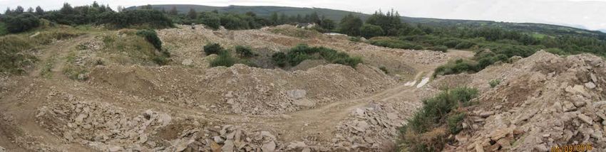
1.2    Rejected sites
A range of sites had been previously flagged for consideration in the IGH Master site list,
and included in the earlier County Development Plan, and some were assessed as
unsuitable for County Geological Site status in this audit. Similarly a range of additional and
new sites were assessed in the audit, based on new knowledge of County Laois’s geology,
and especially for Quaternary landscape sites and karst sites. Other sites were visited on
spec during fieldwork. The rejected sites are listed below with brief notes as to why they
were assessed as unsuitable for inclusion.

Boley Pit
This site is listed on the Geological Survey of Ireland Active Quarries Directory of 2014.
Located at Boley, west of Abbeyleix, the sand and gravel pit is still active today, but has
little exposure and much backfilled area. Given the lack of good sections and any
representative sedimentology, the site was rejected for inclusion as a County Geological
Site.

                                     Figure 1. Boley Pit

Killeany Pit II
This site was surveyed in the field following its discovery as a large pit, on the aerial
photographs of the River Barrow valley in the east of County Laois. The site is not listed
on the Geological Survey of Ireland Active Quarries Directory of 2014.

Located at Killeany, between Ballybrittas and Vicarstown, the sand and gravel pit is no
longer active, though it was a considerable operation in the past. The pit is being backfilled
and has no extant faces left. Owing to this lack of good sections and any representative
sedimentology, the site is rejected for inclusion as a County Geological Site.

                                              9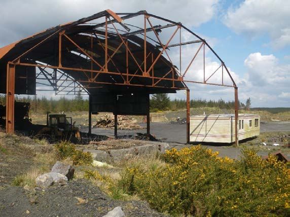
Figure 2. Killeany Pit II

Biddy Aghaboe’s Well
This well is located at the grid reference given (in error) for the Darken Well in the Irish
Geological Heritage Master Site List. The well, though present, has been covered by a
railway bridge and is therefore no longer visible, though a plaque erected by CIE when the
bridge was constructed records the well location.

The site is an important one in the folklore of Portlaoise, as Biddy Aghaboe, who found the
well as she walked the road out of the town towards Mountrath, is supposed to have saved
the town from drought with the well’s discovery.

                              Figure 3. Biddy Aghaboe’s Well

Right: Sketch of the legend of Biddy Aghaboe’s Well. From ‘Laois Folk Tales’ by Nuala
Hayes, The History Press, 2015.

                                             10
River Barrow, Athy to Carlow
This stretch of the River Barrow, along the Laois county boundary between Athy and
Carlow Town, was included in the IGH Master Site List, as a good example of ‘glaciofluvial
inheritance’. The landscape here is quite subdued though, with no well-defined glaciofluvial
terraces occurring, or any other distinctive glaciofluvial features. With no exposure either,
the locality seems like a subdued expression of potential glaciofluvial gravels, rather than a
definitive landform sequence. On this basis the site is rejected.
Figure 4. River Barrow, Athy to Carlow
New Rossmore
This is the site of an underground coal mine developed in the 1970s and 1980s. Like Old
Rossmore, 1 km to the southeast, the mine exploited the No. 2 or Marine Band seam. The
site covers some 2.5 ha and contains some derelict buildings and processing plant,
including the remains of a large shed and conveyor. The excavation on the western part of
the site has no exposure of coal and appears to have been quarried for sandstone. None of
the features observed on the site have extant geological heritage interest and therefore
New Rossmore is rejected as a County Geological Site.
Figure 5. New Rossmore
11Ross Flagstone Quarry
This site is one of two quarries where Clonaslee Flagstones are seemingly being extracted,
at least on a sporadic basis. However, detailed examination of the quarried area shows
extensive amounts of disturbed ground, and rock piles, but only one small face of exposed
rock where it is possible to examine the gross characteristics of the Clonaslee Member of
the Cadamstown Formation. The lack of actual exposure and interest here means that it
does not qualify as a County Geological Site.
Figure 6. Ross Flagstone Quarry
Trooper’s Quarry
This site has two very small old flagstone quarries. The named quarry on Ordnance Survey
maps is very small, perhaps only about 10m long and 2-3m wide. It is totally overgrown,
very shallow and displays no geology. A slightly larger quarry close by, without a name, at
the end of the vehicular track which is the access road to a house, does have a small face
exposed. This is partly because some recent extraction (the subject of legal dispute) has
left a few metres of rock visible, with flags on top of thicker sandstone beds. However,
neither quarry is significant enough to consider as a County Geological Site.
Figure 7. Trooper’s Quarry
122. Laois Council Policies regarding geological heritage
It is worth drawing attention to the excellent treatment of geological heritage in the Laois
County Development Plan, which could be a model for any local authority to follow. The
policy section on Designated Areas, clearly recognises the underlying geodiversity
foundation of many biodiversity designations and incorporates it in a more holistic way than
is frequently encountered in such Plans.
The specific section on geology is a concise statement of all essentials that could be
aspired to in regard to geological heritage within a County Council. The completion of this
geological heritage audit will ensure that the largely desk-based study and listing of County
Geological Sites (CGS) is superseded in the new Draft County Development Plan 2017-
2023 by a robust selection of sites that are important in County Laois. Whilst some are
candidates for NHA designation in the future if the geological NHAs ever become a reality,
new CGS that are purely of local importance have been added. Equally some sites have
been rejected after proper field auditing.
It is the policy of the Council to:
NH9 No projects giving rise to significant cumulative, direct, indirect or secondary impacts
on Natura 2000 sites arising from their size or scale, land take, proximity, resource
requirements, emissions (disposal to land, water or air), transportation requirements,
duration of construction, operation, decommissioning or from any other effects shall be
permitted on the basis of this plan (either individually or in combination with other
plans or projects[6]).
NH10 Assess, in accordance with the relevant legislation, all proposed developments which
are likely to have a significant effect (directly or through indirect or cumulative impact)
on designated natural heritage sites, sites proposed for designation and protected
species;
NH11 Protect Natural Heritage Areas (NHA) from developments that would adversely affect
their special interests;
NH 12 Recognise and protect the significant geological value of sites in County Laois and
safeguard these sites, in consultation with the Geological Survey of Ireland and in
accordance with the National Heritage Plan and “Geological Heritage Guidelines for
the Extractive Industry”;
NH 13 Support and co-operate with statutory authorities and others in support of measures
taken to manage designated nature conservation sites in order to achieve their
conservation objectives;
NH 14 Promote development for recreational and educational purposes that would not
conflict with maintaining favourable conservation status and the meeting of the
conservation objectives for designated sites.
NH15 Engage with the National Parks and Wildlife Service to ensure Integrated
Management Plans are prepared for all Natura sites (or parts thereof) and ensure that
plans are fully integrated with the County Development Plan and other plans and
programmes, with the intention that such plans are practical, achievable and
sustainable and have regard to all relevant ecological, cultural, social and economic
considerations and with special regard to local communities.
Geology is an intrinsic component of the natural heritage of Laois. The Geological Survey of
Ireland established the Irish Geological Heritage Programme in 1998. The programme is
identifying and selecting the very best nationally important CGS sites for NHA designation,
13to represent the country’s geology. It is also identifying many sites of national or local
geological heritage importance, which are classed as County Geological Sites (CGS).
These sites will be protected primarily through their inclusion in the County Development
Plan.
GEOLOGY
It is the policy of the Council to
GEOL1 Protect from inappropriate development the County Geological Sites listed in Table
28 as notified by the Geological Survey of Ireland;
GEOL2 Protect geological NHAs as they become designated and notified to the Local
Authority, during the lifetime of the Plan;
GEOL3 Encourage, where practicable and when not in conflict with ownership rights,
access to geological and geomorphological features.
143. Geological conservation issues and site management
Since geodiversity is the often forgotten foundation for much of the biodiversity
which has been identified for conservation through SAC or NHA designation, it is
unsurprising that many of the most important geological sites are actually in the same areas
as SAC and NHA sites. In these areas, the geological heritage enhances and cements the
value of these sites for nature conservation, and requires no additional designation of actual
land areas, other than citation of the geological interest.
Broadly speaking, there are two types of site identified by the IGH Programme. The
first, and most common, includes small and discrete sites. These may be old quarries,
natural exposures on hilly ground, coastal cliff sections, or other natural cuttings into the
subsurface, such as stream sections. They typically have a feature or features of specific
interest such as fossils or minerals or they are a representative section of a particular
stratigraphical sequence of rocks. The second type of site is a larger area of
geomorphological interest, i.e. a landscape that incorporates features that illustrates
the processes that formed it. The Quaternary theme and the Karst theme often include
such sites. In County Laois, with a high proportion of land area under grassland, the only
such site is the Clonaslee Eskers. [See facing page]
It is also important from a geological conservation perspective that planners understand the
landscape importance of geomorphological features which may not in themselves warrant
any formal site designation, but which are an integral part of the character of County Laois.
A lack of awareness in the past, has led to the loss of important geological sites and local
character throughout the country. In County Laois a 2010 Draft Landscape Characterisation
Assessment was completed and incorporated into the County Development Plan 2011-
2017. This provides a tool for planners to help maintain the character of the County. An
action in the Heritage Plan is to keep heritage concerns at the forefront of the Assessment.
The Strategic Environmental Assessment within the County Development Plan also
provides tools. In addition, the now routine pattern of consultations with GSI, either by the
planning department or by consultants carrying out Environmental Impact Assessment, plus
strategic environmental assessment (SEA), has greatly improved the situation.
There are large differences in the management requirements for geological sites in
comparison to biological sites. Geological features are typically quite robust and generally
few restrictions are required in order to protect the scientific interest. In some cases,
paradoxically, the geological interest may even be served better by a development
exposing more rock. The important thing is that the relevant planning department is
aware of the sites and, more generally, that consultation can take place if some
development is proposed for a site. In this way, geologists may get the opportunity to
learn more about a site or area by recording and sample collection of temporary exposures,
or to influence the design so that access to exposures of rock is maintained for the future,
or occasionally to prevent a completely inappropriate development through presentation of
a strong scientific case.
In many counties, working quarries may have been listed because they are the best
representative sections available of specific rock sequences, in areas where exposure is
otherwise poor. No restriction is sought on the legitimate operation of these quarries.
However, maintenance of exposure after quarry closure is generally sought in agreement
with the operator and planning authority in such a case. At present, working quarries like
15Farnans Quarry, Carroll’s Quarry and Ballyadams Quarry are now included as County
Geological Sites in County Laois. These issues are briefly explored in a set of Geological
Heritage Guidelines for the Extractive Industry, published jointly by the GSI and the Irish
Concrete Federation in 2008.
A new quarry may open up a window into the rocks below and reveal significant or
particularly interesting features such as pockets of fossils or minerals, or perhaps a karstic
depression or cave. Equally a quarry that has finished working may become more relevant
as a geological heritage site at that stage in its life. It may need occasional maintenance to
prevent overgrowth of vegetation obscuring the scientific interest, or may be promoted to
the public by means of a viewing platform and information panel.
Nationally, specific sites may require restrictions and a typical case might be at an
important fossil locality or a rare mineral locality, where a permit system may be required for
genuine research, but the opportunity for general collecting may need to be controlled.
However, County Laois’s sites are not likely to require such an approach.
Waste dumping
An occasional problem throughout the country, including in County Laois, is the dumping of
rubbish in the countryside. The dumping of waste is not only unsightly and messy, but when
waste materials are dumped in areas where rock is exposed, such as in quarries or disused
gravel pits, they may leach into the groundwater table as they degrade. This can cause
groundwater pollution and can affect nearby drinking water supplies in wells or springs.
Groundwater Protection Schemes (DELG 1999) help to combat pollution risks to
groundwater by zoning the entire land surface within counties into different levels of
groundwater vulnerability. County Laois was included in a national scheme for
Groundwater Protection in 2012, thus ranking the county land surface into vulnerability
categories of ‘Extreme’, ‘High’, ‘Moderate’ and ‘Low’, and helping planners to assess which
developments are suitable or not in some areas of County Laois.
New exposures in development
One less obvious area where the Local Authority can play a key role in the promotion and
protection of geology is in the case of new roads. Wherever major new carriageways are
to be built, or in other major infrastructural work, it should be a policy within the Planning
Department, that where new rock exposures are created, they be left open and
exposed unless geotechnical safety issues arise (such as where bedding dips are prone to
rock failure). The grading and grassing over of slopes in cuttings is largely a civil
engineering convenience and a mindset which is difficult to change. However, it leads to
sterile and uninteresting roads that look the same throughout the country. Leaving rock
outcrops exposed where they are intersected along the road, improves the character and
interest of the route, by reflecting the geology and landscape of the locality. Sympathetic
tree or shrub planting can still be done, but leaving bare rocks, especially where they show
interesting features, not only assists the geological profession, but creates new local
landmarks to replace those removed in the construction of the roadway. This can also
potentially save money on the construction costs. It may also contribute to road safety by
providing diversity of surroundings to maintain drivers’ attention.
In Laois, because of the relatively subdued terrain, the opportunity for such rock road
cuttings has been limited. The motorway improvements on the M8 and M7 have produced
two long cuttings at Addergoole near Rathdowney and at Derryvorrigan near Borris in
16Ossory, respectively, that are included as CGSs in this audit. Other roads in the county are
less likely to be significantly upgraded but the option should be borne in mind for all future
road improvements.
Geoparks
An extremely interesting development in geological heritage, not just in Europe but
internationally, has been the rapid recent growth and adoption of the Geopark concept. A
Geopark is a territory with a well-defined management structure in place (such as Local
Authority support), where the geological heritage is of outstanding significance and is
used to develop sustainable tourism opportunities. Initially it was largely a European
Geoparks Network (EGN) but since 2004 has expanded worldwide as the Global Geoparks
Network (GGN) and is fully assisted by the United Nations Educational, Scientific and
Cultural Organisation (UNESCO) [see www.globalgeopark.org and
www.europeangeoparks.org]. A fundamental theoretical basis of the Geopark is that it is
driven from the bottom up – the communities in the Geopark are the drivers of the project
and are the main beneficiaries. The Geopark branding therefore helps promote the
geological heritage resource so that the community can benefit from it.
In Ireland there are three members of the Geoparks Network. One is the cross-border
Marble Arch Caves Global Geopark in Fermanagh and Cavan [see
www.marblearchcaves.net and www.cavancoco.ie/marble-arch-caves-global-geopark]. The
Copper Coast Geopark in Waterford also joined the Network in 2001 [see
www.coppercoastgeopark.com]. A now well established addition has been the Burren and
Cliffs of Moher in County Clare [see www.burrengeopark.ie]. In addition there are aspirant
groups exploring the work and infrastructure required for applications in other areas such as
Joyce Country in Mayo and Galway, and the cross-border Mourne Cooley Gullion area. At
present, we do not consider the geodiversity in the county as likely to meet the criteria for a
Geopark application.
173.1 A Note on Esker Conservation in County Laois
What is an esker?
Eskers are long, sinuous ridges of glaciofluvial sands and gravels. The term “esker” is an English
rendering of the Gaelic word eiscir which means 'a high ridge separating two flat plains'. They
range from a few tens of metres to over a hundred kilometres in unbroken length, and range locally
from a few metres to over 50m in height, and from ten metres to hundreds of metres in width at their
base. Eskers have been reported from all over mid-latitudes, and are common in Ireland, Britain,
Scandinavia, Canada, Alaska, the northeastern U.S., and Patagonia. .
Since eskers are made up of highly permeable sand and gravel, they are frequently excavated for
construction. They have been considered an endangered geomorphological species in many parts
of the world for some time (notably, southern Quebec and Finland), since they have been used
either to develop roadways, offering natural elevated, dry terrain, or they have been ripped up for
gravel to build nearby roads. The latter has been the case in Ireland for some time, and recent
efforts have focussed on conserving eskers for their geomorphological, habitat, groundwater and
educational resource.
How are eskers formed, geologically?
Eskers are usually the infillings of ice-walled river channels. Just as rivers on land carry and deposit
sediment, meltwater that flows in the openings beneath, above and within a glacier also carries and
deposits sediment. Tunnels near the base of retreating glaciers fill with transported sediments,
which remain as sandy or gravelly ridges that look like raised, upside-down stream beds after the
glacier melts away.
Eskers in Ireland.
A large system of esker landforms spans the ‘Irish Midlands’, or central lowland portion of the
country. These ridges have been the subject of geomorphological and geological study since the
mid-nineteenth century. The eskers are composed of sorted, layered sediments but range in size,
orientation and morphology, generally related to the movement patterns and ice margin locations of
the last ice sheet to cover the country.
Esker conservation and the aggregate industry
Aggregates can only be extracted where they occur. Extraction is limited to certain geological
areas, which are often areas of inherent beauty or value because of the relationship between
geology and the landscape. This is a problem particularly with eskers, as they are upstanding, dry
ridges of sand and gravel which can be easily quarried, and yet are important in the landscape
topographically, ecologically and historically.
Many of the best examples of eskers in County Laois have been extensively quarried, to such an
extent that little of them actually remain anymore. In particular, much of the Ridge of Maryborough
has been removed, relatively recently, in the southern outskirts of Portlaoise, and of the five
separate segments of the Timahoe Esker, only two remain intact. It is imperative that the balance is
found between geological heritage conservation and aggregate extraction in the future, to ensure
that the best examples of our eskers are protected. The Irish Geological Heritage Audit of County
Laois should help in this process.
184. Summary and Recommendations
Since it is one of the smaller Irish counties and because bedrock is generally not well
exposed, County Laois is not widely known for its geological heritage. However, it has
some fine but underappreciated geological sites. The County Council’s support for this audit
is critical in raising the profile of geological heritage in County Laois and for maximising its
potential, since some of the sites may be otherwise overlooked.
This report documents what are currently understood by the Irish Geological Heritage
Programme (IGH) of the Geological Survey of Ireland (GSI) to be the most important
geological sites within County Laois. It documents them as County Geological Sites (CGS),
for inclusion within the County Development Plan (CDP). The audit provides a detailed
study of sites to replace a provisional listing based on desk study which was adopted in the
current 2011-2017 CDP, along with strong policies to protect it and enhance access where
feasible. [See facing page]
County Geological Sites do not receive direct statutory protection like Natural Heritage
Areas (NHA) but receive an effective protection from their inclusion in the planning system.
Some of the sites described in this report are considered to be of national importance as a
best representative example of a particular geological formation or feature. Old Rossmore,
for example, is perhaps the only good exposure of a coal measure sequence, including a
coal seam, on a national basis. If resources within GSI and National Parks and Wildlife
Service (NPWS) allow, such sites may be notified to the NPWS by the GSI for designation
as a Natural Heritage Area (NHA) once due survey and consultation with landowners is
complete. In other counties, many of the sites fall within existing pNHAs and SACs where
the ecological interest is actually founded upon the underlying geodiversity. In Laois, one
CGS lies within a SAC/NHA: the Clonaslee Eskers (000859), whilst the Timahoe Esker
CGS forms pNHA 000421.
The commission of this audit and adoption of the sites within the CDP ensure that County
Laois follows a now established and effective methodology for ensuring that geological
heritage is not overlooked in the general absence of allocated resources for progress at
national level. It places County Laois at the current focus of geological conservation in
Ireland.
This report is written in non-technical language (with a glossary for unavoidable geological
terminology) as a working document for use by the Heritage Officer and the Planning
department of Laois County Council. It will also be made available via the Council website
for the people of County Laois. A chapter of the report includes recommendations on how
to best present and promote the geological heritage of County Laois to the people of the
county. It will also inform the work of the IGH Programme and be made available through
the GSI website.
The preliminary sections, summary geological history and accompanying map, timescale
and stratigraphical column particularly may be used as they stand to preface a booklet or as
website information in the development of this work, and for information, as seen fit by the
Heritage Officer. The contents also provide the essential ingredients for a public-oriented
book on the geological heritage of County Laois, if the funding can be found to produce it.
194.1 Proposals for promotion of geological heritage in County Laois
The Laois Heritage Plan 2014-2019 included a specific action (20) regarding a geological
heritage audit and the decision by the Heritage Officer to commission an audit of geological
heritage sites in Laois (along with those in County Offaly in a joint approach) in conjunction
with the Geological Survey of Ireland in 2016. This is a most welcome and positive step, for
a topic that is often undervalued and poorly known in the wider community.
This section examines the existing objectives in the Laois Heritage Plan relating in any way
to geological heritage and provides specific suggestions as to how these may be
implemented, supported or enhanced by this audit of geological heritage sites in the county.
OBJECTIVES AND ACTIONS OF THE LAOIS HERITAGE PLAN
Objective 1: Increase understanding of the heritage of Laois
2. Develop the Laois Heritage website and use as a showcase for the heritage of Laois, the work of
the Forum and as a portal allowing access to other sources of heritage information, including the
Heritage Council’s Heritage Map Viewer and the websites of State agencies which display valuable
data on the heritage of the County.
Audit Action: It is hoped that the geological site data in this audit will contribute to the Laois Heritage
website.
3. Continue to raise awareness of the benefits of new technology for interpretation of heritage sites
– run training in the development of interpretation using new technology, in association with Laois
Partnership.
Audit Action: The audit provides much data and material that could form an interpretation project using
new technology, with a focus on training.
4. Disseminate information on the heritage of the County through the use of digital technologies
such as Smartphone apps, multi-media presentations (audio, video guides, etc.) and social
networking sites such as Facebook, Twitter, Google+, Pinterest, etc.
Audit Action: The audit provides much data and material that could form an interpretation project using
new technology.
5. Continue publication of books, posters and leaflets on various aspects of the heritage of Laois
(both by theme and by target group).
Audit Action: The audit report provides the material which could be readily distilled into an accessible
book on the geological heritage of Laois, if sufficient resources are available for the preparation and
production.
6. Investigate the feasibility of developing downloadable applications to increase awareness of
heritage sites, e.g. Laois Gardens Trail, Timahoe Esker Trail, and important monuments, e.g. Rock of
Dunamase.
Audit Action: The audit may provide sufficient raw material to provide applications on some geological
heritage sites.
207. Continue to organise conferences, talks and seminars on heritage-related topics, including
the annual Celebrating Laois Heritage Conference. Target staff of Laois County Council through
awareness raising seminars and workshops at lunchtime.
Audit Action: The authors of this geological heritage audit could potentially provide a talk or seminar on
geological heritage for an appropriate occasion and audience, by arrangement with the Heritage Officer.
9. Continue to promote wider awareness of all aspects of heritage in Laois through participation in
national programmes and events such as Heritage Week, Water Day, Biodiversity Day and Tree
Week.
Audit Action: The authors of this geological heritage audit could potentially provide an event on geological
heritage for an appropriate programme, by arrangement with the Heritage Officer.
12. Liaise with Teagasc and the Farming Organisations to produce and distribute heritage related
information of relevance to the farming community. Support the work of Teagasc in co-ordinating
the delivery of agri environmental awareness events for farmers, to raise awareness of wildlife
habitats, watercourses, farm built heritage (architecture and archaeology) and traditional orchards.
Audit Action: The authors of this geological heritage audit could potentially provide an input on geological
heritage for an appropriate training programme or information publication, by arrangement with the
Heritage Officer
14. Support efforts to promote heritage-related tourism, including in the Slieve Blooms and in
particular Eco-tourism. Work with Laois Tourism and other tourism groups to promote and
maximise the economic and tourism value of our heritage, particularly harnessing the goodwill and
publicity associated with existing festivals and events.
Audit Action: The audit may provide some tourism providers with additional elements of interest, on the
geological heritage, which could enhance their offerings.
Objective 2: Record the heritage of Laois
19. Audit existing surveys/inventories of heritage relating to Laois. Use these to develop and
implement a prioritised programme for research and surveys where there are gaps in knowledge, in
partnership with national and regional bodies. Continue to support the Heritage Council’s Heritage
Map Viewer and use this to highlight gaps in heritage data.
Audit Action: It is envisaged that the relevant data in the audit of geological heritage report will be added
to the Heritage Council Map Viewer
20. Carry out an audit of County Geological Sites, using existing resources such as data held by the
Geological Survey of Ireland, and the recent publication The Geology of Laois and Offaly by Dr. John
Feehan. Use the results of this audit to inform County Development Plan policy in relation to
geological heritage.
Audit Action: The delivery of this audit report achieves this action, once the County Development Plan has
integrated the data and adopted appropriate policy.
23. Support Bord na Móna in the implementation of the Bord na Móna Biodiversity Action Plan
2010-2015, which includes plans to carry out a baseline ecological survey of its various properties
within Laois.
21Audit Action: The geodiversity foundation of many biodiversity sites, such as Abbeyleix Bog, should not be
overlooked in this action.
24. Support Coillte in carrying out surveys of designated Biodiversity sites in its ownership and sites
selected for inclusion in the various LIFE-Nature Programmes around the county.
Audit Action: The geodiversity foundation of many biodiversity sites should not be overlooked in this
action.
25. Support the National Parks and Wildlife Service in protecting important sites for biodiversity
and carrying out ecological survey work throughout Laois.
Audit Action: The geodiversity foundation of many biodiversity sites should not be overlooked in this
action.
26. Work with NGOs such as the Irish Peatland Conservation Council, Bat Conservation Ireland, The
Irish Wildlife Trust, BirdWatch Ireland and others in promoting awareness and collecting
biodiversity data for Laois.
Audit Action: The geodiversity foundation of many biodiversity sites should not be overlooked in this
action.
Objective 3: Protect and promote active conservation of the heritage of Laois
29. Work with relevant agencies and individuals to promote opportunities for ecological
rehabilitation of disturbed sites such as quarries, landfills, cutaway peatland and forestry.
[In the cases where rehabilitation projects are in or adjacent to Natura 2000 sites then Appropriate Assessment Screening
will required of individual projects.]
Audit Action: A holistic approach to such rehabilitation can ensure that both newly-engendered ecology
and rock and subsoil exposures can complement each other in such localities.
32. Continue to work with communities to ensure the ongoing conservation and maintenance of
graveyards.
Audit Action: The geodiversity component and character of local and imported rock types for gravestones
should not be overlooked in this action.
35. Work with Bord na Móna and the Abbeyleix Bog Committee in their work to conserve and
develop educational opportunities at Abbeyleix Bog, and provide advice when required through the
Technical Advisory Group.
Audit Action: The geodiversity component of the site should not be overlooked and the site report and the
authors of this geological heritage audit report may provide appropriate advice.
39. Support the development of Architectural Conservation Areas in Laois through collection of
data, promotion of community participation and awareness raising
Audit Action: The importance of geological character of available local rock sources for both ashlar work
and vernacular buildings and walls should not be overlooked in this action.
Objective 5: Promote enjoyment and accessibility of heritage
45. Publish a list with accompanying maps of heritage sites which are open to the public in Laois.
This to be published online with interactive mapping.
22Audit Action: The online mapping can include any County Geological Sites which are accessible to the
public, such as the Timahoe Esker.
49. Investigate development of a Geological Heritage Trail using the recent publication The Geology
of Laois and Offaly by Dr. John Feehan, and the results of the Survey outlined in Action 20.
Audit Action: The authors of this geological heritage audit are willing to collaborate on this and some
suggestions are given elsewhere in the report.
50. Support the maintenance of existing way-marked ways and other recreational routes in Laois,
and promote development of new walking and cycling routes in association with communities,
landowners and State agencies. Promote the principle of heritage audits of routes and
interpretation of heritage features along recreational routes. Work with Forward Planning and
Sports Office to promote development of high quality new cycling and walking routes in association
with communities, landowners and State Agencies
Audit Action: The authors of this geological heritage audit are able to provide relevant geological heritage
and geodiversity input to any route developments that progress.
234.2 Ideas for projects
Leaflets
No existing leaflets on the geological heritage of County Laois are known, other than the
Geoschol one included as an appendix here. There is some scope for other and different
leaflets. Any leaflets produced could simply be made available as pdf downloads on the
Council’s website to avoid printing costs.
Guides
There are no known specific guides to the geology of County Laois, apart from the superb
book ‘The Geology of Laois and Offaly’ by John Feehan, which is as comprehensive and
readable an account as you could wish for. The 1:100,000 GSI map reports for Sheets 15,
16, 18 and 19 cover County Laois and are also essential resources.
Figure 8. Cover of The Geology of Laois and Offaly
There is scope for guides at different levels of detail and accessibility to non-specialists. A
wide range of leaflets, booklets, books and other media are all feasible, but the research
and production of appropriate text and images is a difficult task to do well without
appropriate experience, and adequate time and resources. It is suggested that with only
modest editing and reorganisation the main content of this report would distil into a
good general short guide to the geological heritage of County Laois, in a broadly
similar style to those books produced for Sligo, Meath, Fingal, Waterford, Roscommon and
Clare following audits in those counties.
Figure 9. Covers of various county popular style books
24Signboards
Simple explanatory or interpretive signboards may be advisable at key geological heritage
locations, but if these are considered, their locations and individual siting should be very
selective, since a proliferation of different interest groups may provoke a ‘rash’ of panels all
over the county. The Planning Section should clearly have a controlling input, in conjunction
with the Heritage Office. It is most likely that a panel combining various heritage interests at
a place is preferred to single interest panels. It is important to consult with potential partners
in the planning stage so that duplication does not occur.
The successful integration of text and graphics on information panels is a fine art, and the
IGH Programme in GSI can offer input if signs are planned for key visitor localities. The
authors of this report are also able to write, review or provide content on geological heritage
for any proposed panels.
Museum exhibitions
As a result of the work to produce this report, the material for a panel based exhibition has
been largely compiled. With some extra research covering human dependence on geology
and resources, an interesting exhibition can be put together for display in the Laois Council
Offices, County Library branches or other venues. The model followed was that used for
Carlow, Dun Laoghaire-Rathdown and Waterford. Images of those and other similar ones
can be seen on the Geological Heritage/Exhibitions section of the GSI website [www.gsi.ie].
New media
There are increasing numbers of examples of new methods of promoting Earth Sciences,
via mobile phone applications and other electronic media. Self-guiding apps on specific
sites would be one of these, such as those produced by Ingenious Ireland for Dublin city
geology and the app for tourists in the Burren and Cliffs of Moher Geopark. Plans for such
products would require some considerable effort to produce and imaginative effort, to link
sites in any coherent ways, other than by their county.
Information on the heritage sites of County Laois can already be found on the ‘Laois
Heritage Trail’ audioguide app available to download for both Android and Apple Devices.
See
http://abartaaudioguides.com/Laois%E2%80%93Heritage%E2%80%93Trail
It is to be hoped that in due course these apps can be updated to include suitable
geological heritage information arising from the audit.
Earth Science Ireland Group and magazine [www.earthscienceireland.org]
The group Earth Science Ireland is an all-Ireland group promoting awareness of Earth
sciences and supporting educational provision in the subject. A main vehicle for the efforts
is the twice a year magazine Earth Science Ireland and this is distributed free to thousands
of individuals, schools, museums, centres and organisations. The editors would welcome
more material from the Republic of Ireland and on County Laois’s geological heritage.
Geoschol website [www.geoschol.com]
Geoschol is an educational project, now essentially represented by a website, which was
largely aimed at producing educational materials on geology for primary schools. A four
page pdf summarising the geology and some highlights of County Laois is already part of
25the available material (see Appendix 6). Working links to the Heritage section of County
Laois Council’s website, as well as to other heritage websites, should be established.
Geological Heritage Research Archive
If the Heritage Officer wanted to do something similar to that produced in the Burren and
Cliffs of Moher Geopark, with downloadable (or links to) free access papers, then a lot of
groundwork is already provided by the reference lists in this audit. Making available
technical references of direct relevance to County Laois geology and geomorphology will
assist many users and researchers into the future. An alternative is that a geological
heritage section with a bibliography pdf on the Heritage web pages for Laois could suffice
for most users.
Maps
It is hoped that geological heritage sites as a data layer might be adopted by the Ordnance
Survey of Ireland in their future map editions of the 1:50,000 Discovery Series, for all
counties where an audit has been completed (similar to the East West maps of Wicklow
which include such data from GSI).
265. A summary of the Geology of County Laois
A single paragraph summary
County Laois has three main episodes in its geological story. The oldest story is represented by the
Slieve Bloom Mountains, where older Silurian marine rocks, from around 425 million years ago are
found in patches where erosion of the uplands has stripped off the younger Devonian sandstones
and conglomerates from river environments, which overlay them. Over most of the county, the
plains are founded on Carboniferous Limestone from around 330 million years ago. These are shelf
limestones from open marine environments. Around 320 million years ago these limestone seas
were replaced by the build-up of sandstones and shales in deltas that extended seawards from the
land. Gradual shallowing of the nearshore led to the emergence of swampy environments filled with
lycopod trees which formed the coal seams of the Leinster (or Castlecomer) coalfield. Around 5
million years ago, the limestones around Stradbally and Portlaoise may have been tropical tower
karst with limestone pinnacles, but if so we see only remnants today, like the Rock of Dunamase,
since the glaciers removed so much during the Ice Age. A veneer of till and some esker ridges are
the other result of the Ice Age.
A simple summary
The landscape of Co. Laois is mostly rather low-lying. In the north-west lies the eastern part of the
Slieve Bloom Mountains, which are formed of the oldest rocks in the county, while in the south-east
is the northern tip of the Castlecomer Plateau, formed of the youngest bedrock in the county. The
oldest rocks in the county occur in several patches towards the centre of the Slieve Bloom
Mountains where erosion has stripped away the younger rocks, but they are only exposed in the
banks of a few streams. These grey mudstones, siltstones and sandstones are Silurian in age,
around 425 million years old (Ma), and were deposited on a deep ocean floor.
Lying above them are red to brown mudstones, sandstones and pebble beds, with occasional
peculiar knobbly limestones called ‘cornstones’. All of these were deposited on river floodplains in
an Equatorial semi-desert environment, with the ‘cornstones’ actually forming within the soils of the
time. Spores are the only fossils that have been found, but they show that these rocks are of earliest
Carboniferous age, just a little less than 360 Ma.
Soon after the start of the Carboniferous, sea level rose to flood across these low plains. The first of
the marine rocks to be deposited were dark grey fossiliferous mudstones, but above these is a
series of thick grey limestones which underlie much of the low ground across the county. At certain
levels these limestones are quite fossiliferous, with shells of brachiopods and nautiloids, corals,
fragments of crinoids, and rarer fossils such as trilobites. Mostly these limestones accumulated as
horizontal layers on a fairly shallow ‘shelf’ sea floor although some of the younger layered
limestones, around 325 Ma, are much darker in colour and were deposited in considerably deeper
water. Although the limestones mostly form low ground across the centre of the county, they are
well exposed in various working and disused quarries and on some of the low hills in the south of
the county.
The low hills in the south-east corner of the county are of younger Carboniferous rocks, between
320 and 315 Ma. The earliest of these particular rocks are black mudstones and thin limestones.
Above them lie sandstones and mudstones that were deposited by river deltas as sea level fell.
Younger still is a series of sandstones and mudstones with thin coal seams, formed from plant
material buried in a swamp, which formed the basis of the once thriving Leinster Coalfield.
27You can also read