Lanner Neighbourhood Plan 2017-2030 Consultation Statement - November 2018
←
→
Page content transcription
If your browser does not render page correctly, please read the page content below
Lanner Neighbourhood
     Plan 2017-2030

Consultation Statement

November 2018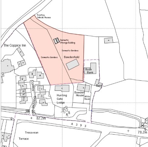
1. Introduction
1.1 This Consultation Statement has been prepared to fulfil the legal obligations of
the Neighbourhood Planning Regulations 2012. Section 15(2) Part 5 of the
Regulations sets out what a Consultation Statement should contain:
(a) details of the persons and bodies who were consulted about the proposed
neighbourhood development plan;
(b) an explanation as to how they were consulted;
(c) a summary of the main issues and concerns raised by the persons consulted;
(d) a description of how these issues and concerns have been considered and,
where relevant, addressed in the proposed neighbourhood development plan.

2. Background leading to the Neighbourhood Plan
2.1 The community of Lanner has been somewhat late in coming to the
Neighbourhood Plan process. The Lanner Parish Plan of 2010 served, in part, to
dampen enthusiasm for a further exhaustive range of consultations and, in part, to
create a (false) sense that this document adequately conveyed community
sentiment towards development and related issues.
Several planning decisions both within and outside the parish boundary, engagement
with the Cornwall Local Plan examination process, and a growing feeling that doing
nothing was the worst option, all led to a change of mind. Lanner Parish Council
raised the advantages and disadvantages of preparing a Neighbourhood Plan in
several newsletters delivered to every household over a period of two years.
2.2 Lanner Parish Council agreed to proceed with a Neighbourhood Plan in July 2016
after almost eighteen months of discussion both within council and with the
community through newsletters. A Steering Group was soon established to comprise
no more than one third councillors and no less than two thirds “non-councillors”.
The Group has met approximately monthly and the “non-councillor” composition
expanded. Application was made to Cornwall Council 22 August 2016 for the whole
parish to be the subject of the Plan and this was confirmed October 2016.

3. First Steps
3.1 The first action of the Steering Group was to arrange a meeting with Emma Ball
and Charlotte Caldwell of Cornwall Council for a briefing on best practice in working
up a Neighbourhood Plan. It was also decided to prepare a Local Landscape
Character Assessment (LLCA) to inform the Plan and provide a practical platform to
draw others (including Lanner School) into the process and a tutorial by Cornwall
Council Landscape Architect Kath Statham was set up. Space would be created
within the Lanner parish council website to promote emerging ideas and discussions
and provide a simple on-line route for comment.
Another early decision was to apply for funding from the Community Rights
Programme and first phase funding of £5,465.00 gained approval 23 December 2016.
3.2 A skeleton plan of action was drawn up. Preliminary “desk-top” research would
provide background for a public consultation to determine the major issues of
concern to the community. This consultation would then inform a questionnaire to
be delivered to each household together with a Housing Needs Survey, Business
Survey and Young Persons’ Survey. An analysis of responses according to location
and grouping within the community would be kept so that additional survey work
could be undertaken if there were significant sampling deficiencies. With this, and
other information drawn from consultation responses and interviews, a draft pre-
submission Plan would be drawn up.
3.3 There was a deliberate decision not to put a timetable to this work but to try and
see it develop by its own impetus. This was potentially a wise move by default, as
falling within the timespan for producing the plan were both a local and a general
election. On the other hand, there was also pressure to move with some speed as
delay creates uncertainty. In the event, the household questionnaire went out mid-
way between the two elections on 12 May 2017.
3.4 Work on the LLCA proceeded throughout the Plan preparation period. A meeting
was held with the Head Teacher of Lanner School early in the process to discuss both
the participation of the school in LLCA and (being the largest employer in the parish)
in the Plan process generally.

4. Consultations
4.1 In addition to the general notice published in the West Briton (responses
received from Cornwall Council Affordable Homes Officer, Natural England, and
Cornwall Council Highways) individual letters of notification requesting comment
and participation were sent in October 2016 to:
        Carharrack parish council; Carn Brea parish council; Gwennap parish council;
        Redruth town council; St Day parish council; Stithians parish council,
        Wendron parish council.
        Cornwall & Isles of Scilly Primary Healthcare Trust, English Heritage,
        Environment Agency, Fire and Rescue Service, Highways Agency, Homes &
        Community Agency, Natural England, Network Rail, Police, World Heritage,
        J Andrews, Carn Marth Trust, Trevince Estate, W Rowe Estates,
        BT, CLA, EE, National Grid, NFU Helston, O2, Redruth Chamber of Commerce,
        Sky Broadband, South West Water. TalkTalk, Virgin Media, Vodaphone,
        Western Power
Anglican Church, British Horse Society, Lanner & District Silver Band, Lanner
Carpet Bowls Club, Lanner Men’s Institute, Lanner School, Lanner Village
Hall, Methodist Church, Neighbourhood Watch, Ramblers,
Carharrack Feed Stores, Coppice Inn, Lanner Fish, Lanner Inn, Lanner Moor
Garage, Lanner Post Office, Lanner Surgery, Letcher Stores, Portreath
Bakery.
4.2 The initial “desktop” research for the Plan also provided context for the ensuing
public consultations. The first port of call was the Parish Plan and the information
and actions generated by that Plan and process. Basic data concerning Lanner was
updated from the Office of National Statistics which had produced fresh data since
the preparation of the 2010 Lanner Parish Plan. Research also necessitated
accumulating, understanding and interpreting policies and data from national,
regional and local sources: particularly the National Planning Policy Framework;
Cornwall Local Plan; (draft) Cornwall Site Allocations DPD; and affordable housing
data.
4.3 Discussions and research conducted with and through Cornwall Council have
been extensive and have included the following: Affordable Housing Team;
Countryside Team; Countryside Access Team; Local Plans Team.
4.4 A Consultation Event was held on 21 January 2017, the aim of which was to
assess which issues were of greatest concern to residents and the results of which
would inform a questionnaire to go out to all households later in the year. The Event
was also seen as an opportunity to spark discussion and interest generally. The Event
was held in the Village Hall from 10:00 to 18:00.
A campaign to promote the consultation process generally and the drop-in
consultation event specifically was run over a period of 10 weeks leading up to that
event through the Lanner website, “Lanner Life” Facebook page, posters on Notice
Boards and in the Lanner Inn, and in the Lanner School newsletters to parents.
The event focussed on stands providing information on general topics and the
opportunity to leave ideas, comments and concerns with a member of the Steering
Group or a parish councillor. As well as providing information about the nature of
NDPs and the process for bringing them into existence, the stands covered Housing
and the Development Boundary; Design and Character; Historic and Built
Environment; Natural Environment and Biodiversity; Employment; Transport;
Climate Change and Renewable Energy; and Community Resilience.
92 people attended the Event.
4.5 A map was made showing where those attended came from within the parish.
This would be used with returns from the questionnaire to determine whether there
were significant areas of under-representation in overall feedback. In terms of
personal profiles, the population of Lanner is 97.3% “white British” suggesting thatthere is little chance of a statistically meaningful under-representation on the basis of ethnicity. Perhaps the greatest risk of under-representation is with “native Cornish” (as an identified National minority) against other “white British”. However, we are unable to identify the significance of “native Cornish” within the community and, in any event, this is not a difference which tends to affect community life. We are confident that age groups, gender and level of ability/disability are all well reflected in engagement with the NDP process. 5 Initial Consultation Responses 5.1 Responses to initial Letters of Notification of Neighbourhood Development Plan Application (as listed in 4.1 above). 5.1.1 Cornwall Council Affordable Homes Team “Proposal: Designation request for undertaking a Neighbourhood Development Plan for the Parish of Lanner Note: Comments are confined only to the affordable housing implications of this proposal and are made without prejudice to any formal decision of the Planning Authority. Summary: The affordable housing team SUPPORT the proposal to designate, however recommends that any Neighbourhood Development Plan permitted take into account the local need for affordable housing and any recent development activity in the area. Relevant Policy Position: Neighbourhood Development Plans (NDP) must conform to local, national and strategic planning policy. In relation to affordable housing, the documents listed below are of particular relevance: The National Planning Policy Framework (NPPF); Former Kerrier District Local Plan (and accompanying SPG / SPD / DPD); The submission draft of the Cornwall Local Plan (2010 - 2030); The Inspector’s preliminary finding Local Plan hearing (May 2015); Post-consultation draft Affordable Housing Supplementary Planning Document (2015) These set out the Local Planning Authority’s (LPA’s) expectations in relation to residential developments contributing towards the delivery of affordable housing, and define delivery mechanisms for this area. Consequently, the Affordable Housing Team would recommend that the documents above be used to inform the evolution of the NDP; its policies; and any site allocations, in due course. In particular, Policy 8 of the emerging Cornwall Local Plan (including the preliminary findings of the Inspector from the hearing in May 2015), suggests that sites within built-up area should provide 25% affordable housing, as the parish lies within Value Zone 5. This effectively applies to any site that is not considered to be a rural exception site (as per the definition within the NPPF). In relation to rural exception sites, Policy 9 of the emerging Local Plan outlines that these should only normally be
permitted if they are genuinely affordable housing-led, with a presumption that a
scheme will provide 100% affordable housing. In circumstances where this would
not be viable without recourse to public subsidy, provision of open market housing
may be supported, subject to meeting the criteria outlined within Policy 9, and
capped at a maximum of 50%.
Following amendments in May 2016 to the Governments National Planning Practice
Guidance (NPPG) within the document ‘Planning Obligations’, the minimum site
thresholds where affordable housing delivery is required has changed.
The new minimum site threshold is 10 dwellings. However, Local Planning
Authorities (LPAs) can apply a lower site threshold of five in Designated Rural Areas
(DRA’s) and Areas of Outstanding Natural Beauty (AONBs).
 In AONBs and Designated Rural Areas the Council is only permitted to seek off site
contributions in lieu of affordable housing on schemes delivering between 6 to 10
dwellings and not seek the provision of on-site affordable housing. The target level
of affordable housing as set out in the emerging Cornwall Local Plan shall continue to
apply (i.e. 25% to 50%, based upon the updated Zone areas within the emerging
Cornwall Local Plan) as a basis for calculation. On schemes of over 10 dwellings the
Council can seek on-site provision of affordable housing. Please note the revised
threshold does not apply to exception sites which are defined as;
Small sites used for affordable housing under in perpetuity where sites would not
normally be used for housing. Rural exception sites Policy 9 (set out above) seek to
address the needs of the local community by accommodating households who are
either current residents or have an existing family or employment connection.
Housing Need: The Council’s housing register (HomeChoice) identifies a high level of
housing need in the Parish, with 144 households registered with a local connection
and in housing need.
New developments should always provide a range of property types, sizes and
tenures, to reflect the need to develop a mixed, yet balanced community. Typically,
the Council’s target provisions are in the following tenure proportions;
70% affordable rented homes
30% intermediate housing for sale
In addition to the identified registered housing need figures above the Affordable
Housing Team is able to offer the NDP Group support to undertake a local housing
needs survey to further assess and enhance the understanding of housing need
locally. Please advise the NDP Group to contact me if they wish to discuss this option
further.
Affordable Housing Details: On the assumption that the proposed NDP will seek to
address the issue of future affordable housing delivery, the Affordable Housing Team
recommends that the following issues be considered: Tenure; Unit mix and size;
Affordability; Delivery mechanisms and partners; Availability of funding; Phasing
(should large sites be promoted); Clustering arrangements (for mixed-tenure
schemes); The provision of flatted accommodation; Adapted/wheelchair accessible
accommodation; Self-build (if identified as a local need)
All development proposals that deliver affordable housing should take account of:
eligibility criterion, nominations procedures and housing allocation policies (i.e.
HomeChoice) already in place by the Council in its role as Local Housing Authority.
 If the NDP seeks to deliver affordable housing through site allocations or other
mechanisms the following should be considered: Neighbourhood Development
Orders; Land ownership, availability, and cost; the deliverability of a site, having due
regard to all material planning considerations; Economic Viability.”
Sarah Roberts 24/08/2016
Steering Group Comment: The adoption of the Cornwall Local Plan obviously affects
much within this initial response. The parish council, and the Steering Group,
profoundly disagree with the Affordable Homes Officer’s headline figure of 144 as
being in any way a true and proper reflection of local need for affordable housing. In
addition, the accommodation of local need in its widest sense through the site
allocations made for the Camborne-Pool-Illogan-Redruth Community Network Area
under the Cornwall Local Plan is not taken into account in the AHO’s assessment.
Conversations with the AHO has secured an analysis and refinement of the headline
assessment. First, applicants who had not renewed their registration for over 12
months despite prompting were removed (by Cornwall Council after their initial
response) which reduced the figure to 103. Applicants with no declared wish to
actually live in Lanner have been removed to reveal a total of 48. Band E applicants
(by definition not “in need” - a prerequisite for a rural exception site) were also
removed (though the AHO did not agree with that removal) to give up a net total of
22. 1
This is, of course, an academic “desk-top” analysis. The Steering Group is keen to
ensure that the real needs of the community are met. The Group has therefore
worked closely with the AHO to undertake a comprehensive survey of housing needs
within the parish and the AHO has issued an identical survey to all those on the
HomeChoice register with a local connection to Lanner but who currently reside
outside the parish. The result of this survey indicates a local need for 16 new
affordable homes (see Section 9 below).
Evidence of local need has been further complicated by a statement from a Cornwall
Council officer at the Examination of the Local Plan Site Allocations DPD in January
2018 that the HomeChoice register has been “cleansed” (his words) from 19,000
applicants to 6,500. Up to May 2018, the Affordable Homes Officer has found himself

1
  As described later, the “discounting” of Band E is removed from the Steering Group’s position and
from the Plan. This follows a new Homechoice policy formally adopted in January 2018.
unable to provide an update of his figures for Lanner. Application of a crude like
reduction to the last figures provided of 103 would suggest a possible new
HomeChoice total of 35 (34.21% of 103) or 16 as a total for those signifying a
preference to live in Lanner).

5.1.2 Highways England
“Thank you for your letter of 24 August providing Highways England with the
opportunity to comment on the application by Lanner Parish Council for designation
of the parish as a Neighbourhood Development Plan (NDP) area.
Highways England is responsible for operating, maintaining and improving the
strategic road network which in this instance consists of the A30 which runs to the
north of the proposed Plan area. We are keen to support the development of
neighbourhood plans and the delivery of local growth and therefore we have no
objection in principle to the parish becoming an NDP area. However, it is possible
that proposals coming forward may have the potential to impact on the strategic
road network, and we would therefore welcome the opportunity to comment
further on the plan as it develops to ensure there is a satisfactory assessment of
traffic impacts and mitigation requirements.
If you have any queries in the meantime please don’t hesitate to contact me or Sally
Parish, the Asset Manager for the A30 in Cornwall.”
Steering Group Comment: This appears to be a standard response with no direct
bearing on the Plan. The wish to comment further on the Plan as it emerges is noted
and will be followed up.

5.1.3 Natural England
“Thank you for your email dated 24/10/2016 notifying Natural England of the above
Neighbourhood Development Plan.
Natural England does not wish to make comment on the suitability of the proposed
plan area or the proposed neighbourhood planning body.
However, we would like to take this opportunity to provide you with information
sources the neighbourhood planning body may wish to use in developing the plan,
and to highlight some of the potential environmental risks and opportunities that
neighbourhood plans may present. We have set this out in the annex to this letter.
Natural England’s role: Natural England is a non-departmental public body. Our
statutory purpose is to ensure that the natural environment is conserved, enhanced,
and managed for the benefit of present and future generations, thereby contributing
to sustainable development. The local planning authority will be aware and should
advise the neighbourhood planning body when Natural England should be consulted
further on the neighbourhood plan.
Planning policy for the natural environment Neighbourhood plans and orders
present significant opportunities, but also potential risks, for the natural
environment. Proposals should be in line with the National Planning Policy
Framework. The key principles are set out in paragraph 109:
The planning system should contribute to and enhance the natural and local
environment by: protecting and enhancing valued landscapes, geological
conservation interests and soils recognising the wider benefits of ecosystem services;
minimising impacts on biodiversity and providing net gains in biodiversity where
possible, contributing to the Government’s commitment to halt the overall decline in
biodiversity, including by establishing coherent ecological networks that are more
resilient to current and future pressures;
The neighbourhood planning body should also consider the natural environment
policies in the area’s Local Plan.
The neighbourhood plan or order should be consistent with these, and the
neighbourhood planning body may decide that the emerging Neighbourhood Plan
should provide more detail as to how some of these policies apply or are interpreted
locally.
The attached annex sets out sources of environmental information and some natural
environment issues you may wish to consider as the neighbourhood plan or order is
developed.
We really value your feedback to help us improve the service we offer. We have
attached a feedback form to this letter and welcome any comments you might have
about our service.”
Steering Group Comment: This is a standard response with no direct bearing on the
Plan. The reference resources provided are both informative and useful in the
formulation of the Plan.
5.1.4 Network Rail
“Network Rail has been consulted on the Lanner Neighbourhood Development Plan
2016 - 2033. Thank you for providing us with this opportunity to comment on this
Planning Policy document.
Network Rail is a statutory undertaker responsible for maintaining and operating the
country’s railway infrastructure and associated estate. Network Rail owns, operates,
maintains and develops the main rail network. This includes the railway tracks,
stations, signalling systems, bridges, tunnels, level crossings and viaducts. The
preparation of development plan policy is important in relation to the protection and
enhancement of Network Rail’s infrastructure. In this regard, please find our
comments below.
Network Rail would draw the council’s attention to the following (which applies to
England only):
The Town and Country Planning (Development Management Procedure) (England)
Order 2015
Publicity for applications for planning permission within 10 metres of relevant
railway land
16.— (1) This article applies where the development to which the application relates
is situated within 10 metres of relevant railway land.
(2) The local planning authority must, except where paragraph (3) applies, publicise
an application for planning permission by serving requisite notice on any
infrastructure manager of relevant railway land.
(3) Where an infrastructure manager has instructed the local planning authority in
writing that they do not require notification in relation to a particular description of
development, type of building operation or in relation to specified sites or
geographical areas (“the instruction”), the local planning authority is not required to
notify that infrastructure manager.
(4) The infrastructure manager may withdraw the instruction at any time by notifying
the local planning authority in writing.
(5) In paragraph (2) “requisite notice” means a notice in the appropriate form as set
out in Schedule 3 or in a form substantially to the same effect.

Developer Contributions

The Neighbourhood Development Plan should set a strategic context requiring
developer contributions towards rail infrastructure where growth areas or significant
housing allocations are identified close to existing rail infrastructure.

Many stations and routes are already operating close to capacity and a significant
increase in patronage may create the need for upgrades to the existing
infrastructure including improved signalling, passing loops, car parking, improved
access arrangements or platform extensions.

As Network Rail is a publicly funded organisation with a regulated remit it would not
be reasonable to require Network Rail to fund rail improvements necessitated by
commercial development. It is therefore appropriate to require developer
contributions to fund such improvements.

Specifically, we request that a Policy is included within the document which requires
developers to fund any qualitative improvements required in relation to existing
facilities and infrastructure as a direct result of increased patronage resulting from
new development.

The likely impact and level of improvements required will be specific to each station
and each development meaning standard charges and formulae may not be
appropriate. Therefore, in order to fully assess the potential impacts, and the level of
developer contribution required, it is essential that where a Transport Assessment is
submitted in support of a planning application that this quantifies in detail the likely
impact on the rail network.
To ensure that developer contributions can deliver appropriate improvements to the
rail network we would recommend that Developer Contributions should include
provisions for rail and should include the following:
A requirement for development contributions to deliver improvements to the
rail network where appropriate.
A requirement for Transport Assessments to take cognisance of impacts to
existing rail infrastructure to allow any necessary developer contributions
towards rail to be calculated.
A commitment to consult Network Rail where development may impact on
the rail network and may require rail infrastructure improvements. In order
to be reasonable these improvements would be restricted to a local level and
would be necessary to make the development acceptable. We would not
seek contributions towards major enhancement projects which are already
programmed as part of Network Rail’s remit.
Level Crossings
Development proposals’ affecting the safety of level crossings is an extremely
important consideration for emerging planning policy to address. The impact from
development can result in a significant increase in the vehicular and/or pedestrian
traffic utilising a crossing which in turn impacts upon safety and service provision.
As a result of increased patronage, Network Rail could be forced to reduce train line
speed in direct correlation to the increase in vehicular and pedestrian traffic using a
crossing. This would have severe consequences for the timetabling of trains and
would also effectively frustrate any future train service improvements. This would
be in direct conflict with strategic and government aims of improving rail services.
In this regard, we would request that the potential impacts from development
affecting Network Rail’s level crossings, is specifically addressed through planning
policy as there have been instances whereby Network Rail has not been consulted as
statutory undertaker where a proposal has impacted on a level crossing. We request
that a policy is provided confirming that:
• The Council have a statutory responsibility under planning legislation to
consult the statutory rail undertaker where a proposal for development is
likely to result in a material increase in the volume or a material change in the
character of traffic using a level crossing over a railway:
o Schedule 5 (f)(ii) of the Town & Country Planning (Development
Management Procedure) order, 2010 requires that… “Where any
proposed development is likely to result in a material increase in
volume or a material change in the character of traffic using a level
crossing over a railway (public footpath, public or private road) the
Planning Authority’s Highway Engineer must submit details to bothHer Majesty’s Railway Inspectorate and Network Rail for separate
approval”.
Any planning application which may increase the level of pedestrian and/or
vehicular usage at a level crossing should be supported by a full Transport
Assessment assessing such impact: and
The developer is required to fund any required qualitative improvements to
the level crossing as a direct result of the development proposed.
Planning Applications
We would appreciate the Parish Council providing Network Rail with an opportunity
to comment on any future planning applications should they be submitted for sites
adjoining the railway, or within close proximity to the railway as we may have more
specific comments to make (further to those above).”
Steering Group Comment: This is a standard response with no direct bearing on the
Plan. There is no land within or immediately adjoining Lanner parish which is known
to be owned or subject to operations by Network Rail.
5.1.5: Stithians Parish Council
“Stithians Parish Council discussed this at their November meeting and, whilst they
are not yet committed to preparing a Neighbourhood Development Plan, the Council
will do all it can to support Lanner and will be represented at the meeting on 21st
January (2017).”
Steering Group Comment: Whilst this response has no direct bearing on the Plan,
the Steering Group is grateful for the support given.
5.1.6. Historic England
Thank you for giving notice that Lanner Parish Council has applied to designate
Lanner as a Neighbourhood Area under Part 2 of the Neighbourhood Planning
(General) Regulations 2012.
Historic England has no objection to this proposal.
We would like to take the opportunity of the consultation to outline the range of
support Historic England is able to offer in relation to Neighbourhood Plans. It would
be helpful if this response can be copied to the Parish Council for their information.
Research has clearly demonstrated that local people value their heritage and
Neighbourhood Plans are a positive way to help communities care for and enjoy the
historic environment.
Historic England is expecting that as Neighbourhood Planning Forums come to you to
seek advice on preparing Neighbourhood Plans they will value guidance on how best
to understand what heritage they have, as well as assistance on preparingappropriate policies to secure the conservation and enhancement of this local heritage resource. Information held by the Council and used in the preparation of your Core Strategy/Local Plan is often the starting point for Neighbourhood Plans. Other useful information may be available from the Historic Environment Record Centre or local environmental and amenity groups. For example, our records show that the area contains 16 Grade II Listed Buildings and 1 Scheduled Ancient Monument. Historic England also publishes a wide range of relevant guidance. Links to these can be found in the appendix to this letter. Plan preparation also offers the opportunity to harness a community’s interest in the historic environment by getting them to help add to the evidence base, perhaps by creating and or reviewing a local heritage list, inputting to the preparation of conservation area appraisals and undertaking or further deepening historic characterisation studies. Historic England has a statutory role in the development plan process and there is a duty on either you as the Local Planning Authority or the Neighbourhood Planning Forum to consult Historic England on any Neighbourhood Plan where our interests are considered to be affected as well as a duty to consult us on all Neighbourhood Development Orders and Community Right to Build Orders. Historic England will target its limited resources efficiently. We will directly advise on proposals with the potential for major change to significant, nationally important heritage assets and their settings. Our local offices may also advise communities where they wish to engage directly with us, subject to local priorities and capacity. Historic England fully recognises that the neighbourhood planning process is a locally-led initiative and communities will shape their own neighbourhood plan as informed by the issues and opportunities they are most concerned about and relevant to the local area. As a national organisation we are able to draw upon our experiences of neighbourhood planning across the country and information on our website might be of initial assistance http://www.historicengland.org.uk/advice/planning/plan-making/improve-your- neighbourhood/. It is envisaged that the website will be progressively updated to share good practice in the management of the historic environment through neighbourhood planning. Should you wish to discuss any points within this letter, or if there are issues about this Neighbourhood Plan Area where the historic environment is likely to be of particular interest, please do not hesitate to contact me. Steering Group Comment: This is a standard response with no direct bearing on the Plan. The reference resources provided are both informative and useful in the formulation of the Plan.
6. Consultation Event Responses
6.1 Climate Change and Renewable Energy          Monitors Ross Marshall and Cornwall
Councillor John Thomas MBE.
There was both awareness and concern regarding climate change but this was
expressed as a need to accommodate and mitigate its effects rather than as a desire
to challenge its causes. The ability and capacity of a small rural community to
influence causes was seen as negligible whereas planning for consequences was
considered essential.
The greatest cause for concern related to flooding. Helping the ground to absorb
rainfall and run-off by avoiding development in sensitive areas and carrying out
strategic tree planting accounted for 45% of views expressed. The run-off from the
trails and cycleways on Carn Marth were highlighted as a particular problem along
with a more general fear about the irregular and infrequent cleansing of drains,
gullies and grips. Associated with this were concerns about the absence or
infrequency of litter collection in particular locations and the failure of coordination
of litter picking with verge trimming, all of which add to the blocking up of water
courses.
There was very little comment about renewable energy. (This could reflect extensive
public concern within the preceding year when a proposed solar panel farm was
fought off: perhaps it was felt that views had been put sufficiently robustly already).

6.2 Community and Resilience        Monitors Veronica Rossignol and Rev. Peter
Fellows.
“People were generally satisfied with the information provided and the way in which
it was presented.
Most comments were about the traffic speeding down the A393 and many
suggested speed cameras at the top and the bottom of Lanner Hill.
Mobile phone signal, or the lack of it, was also a cause for concern.
There were enquiries about the Post Office and, surprisingly, not everyone knew
about the excellent service we now have in the Village Hall on Tuesday and Thursday
afternoon.
 ‘Parking’ and the lack of it was talked about. There were also many people who
reflected on the Lanner Emergency Plan meeting (held December 2016), plus a
repeat list or poster of a suggested crisis pack. (The Emergency Plan and the Crisis
Pack list will be on the parish council website once the final Emergency Plan is
approved).
One person suggested a Defibrillator to be situated in an accessible position in the
Square. This has also been brought up at Neighbourhood Watch meetings. (This is a
subject which has been discussed in depth by the parish council with a full briefing by
the leading area coordinator. However, it has been decided not to proceed on
grounds of cost and practicality).
Neighbourhood Watch added 9 more members to the Scheme from the Consultation
Event”.

6.3 Design and Character                 Monitor Rob Lambourne
A series of plans and drawings were prepared and displayed as visual aids to a series
of questions asked of consultees to determine attitudes and concerns. The questions
posed required only a simple multiple-choice response.
91% of respondents preferred multi-unit development sites to be for a maximum of
10 dwellings, the remainder expressing no preference. Again, 91% would prefer to
see development as infill either within the village settlement boundary or on
brownfield sites. 9% considered greenfield sites to be acceptable.
The same proportion – 91% - held that extensions to dwellings should be
proportional to the existing building and the plot size. 5% did not have concerns over
restricting the size of extensions and 4% expressed no opinion.
In considering extensions to the front of a property, 68% thought this was generally
inappropriate and to be avoided. 14% had no problem with the idea of extensions
coming forward of the building line whilst the remaining 18% thought each case
should be considered on its merits.
95% held that all new developments, including extensions, should provide the ability
for storm water run-off to be dealt with on-site. The remaining 5% questioned as to
whether this was achievable in all situations.
Respondents were asked if, where possible, new building should use materials in
keeping with local building identity: to which 95% were in favour.
86% considered that all new dwellings should provide on-site parking space for two
vehicles. The remaining responses were more or less equally divided between no
parking provision, space for one vehicle, or space for more than two vehicles.
Other comments received were for new builds to have capacity for loft/upward
conversions/extensions; for a policy on empty houses (this is something subject to
Local Plan policy); environmental/embedded energy to be taken into consideration
when evaluating building materials; and a call for more pro-active enforcement
action.

6.4 Employment                            Monitors Mary Anson and Mike Rabey
This subject received the weakest response from those attending and was the least
helpful in the framing of the questionnaires and surveys to be sent out. Whilst there
was a wish list for a range of new businesses to open up in the village, there was also
a realisation that the existing businesses need to be supported better if they are to
be retained.
The importance of broadband both as a prerequisite to attracting businesses and in
retaining them was appreciated and the weaknesses of the present service well
voiced.

6.5 Historic Environment and Heritage     Monitors Chris Bosworth and Helen Bilham
“As a starting point to encourage residents to consider Lanner’s historic
environment and heritage, a map with several spots of interest (not exhaustive) was
displayed with photos illustrating our parish both in the present and past.
Questions to prompt discussion were also asked, for example:
   1. Should the Old Coal Yard on the Tresavean Trail be preserved or used for
      housing? Interestingly, a notable number of residents were unsure of this
      particular location. A mixed bag of responses varying from no development,
      thus helping to maintain the natural break from Redruth, to an opportunity
      to develop a brown field site. (This site was subject to a planning application
      fairly recently but was refused permission with objections coming from
      several bodies including the parish council and World Heritage).
   2. Which buildings do you value in Lanner for their historic interest? (There was
      much interest in this topic and it will be included in the Household Survey for
      detailed response).
   3. Should Tresavean be kept as an amenity and site of historic interest? This was
      supported by a survey with the question “How much to you value the history
      of Tresavean?” 93% of the respondents rated it as high. There is a significant
      nostalgic attachment to Tresavean as well as value linked to the mining
      history of this particular area and the repeated comment was Tresavean is
      viewed as a recreational asset as well as a historic one.
   4. A second survey was conducted. “How much do you value the history of Carn
      Marth?” 100% of respondents rated this as high. Of these, only 7% had not
      walked any of the footpaths on Carn Marth but they still acknowledged it as a
      highly important area of Lanner.

Overwhelmingly, the photographs prompted many memories and, voiced within
those, a strong insistence that Lanner should maintain its identity and most certainly
not meld into Redruth.
Another resource displayed was a map from Cornwall Council of the listed buildings of which there are 17 (including 5 stones on Carn Marth). A commonly held thought was that both Carn Marth and Tresavean had been granted some sort of status, and if not then they should. (In fact, only Carn Marth has AGLV status). A series of photographs that provoked particular comment was three taken from a similar perspective from Tresavean in 1910, 1990 and just one week prior to this Event. These images show the development that has taken place and how fields have been replaced with housing. Consensus was that continuing developments will be to the detriment of the views from Tresavean and there was a similar concern over the encroachment on Carn Marth”. 6.6 Housing and the Development Boundary Monitors Tim Luscombe and Ashley Wood The presentation sought to stimulate thoughts on how much new housing might be required, what type of housing, and where it might be located. 79% of those expressing a view saw some need for more housing but this was inevitably qualified in one way or another. 21% made a positive statement that they wished no new housing development whatsoever, but the reasons were unclear other than they considered the overall population high enough. The suggested village settlement boundary was well understood and received almost universal approval, often with the added comment that there is a need to preserve both the identity of the village and its rural backdrop of open countryside. Although the overwhelming majority saw a need for development almost no one thought this should be substantial in size or impact whether open market housing or affordable/social housing. Infill or rounding off received unqualified support from 23% but 30% felt there should be no development without infrastructure improvements: the capacity of the local school and concerns over flooding were the most cited worries. 10% of comments from those who considered there was some need to build more houses specifically stated they did not want to see any large developments (in addition to those supporting infill). 15% acknowledged a likely need for affordable housing (although the appropriateness of the word “affordable” was often questioned) but were clear that they thought such houses should be for local people only. 8% thought it would be beneficial to build 1 or 2-bedroom properties to facilitate downsizing. 6.7 Natural Environment and Biodiversity Monitors Carole Allen and Ann Shannon Dog fouling was very much to the fore of concerns with suggestions of new bins for Wheal Buller car park, Ankervis Lane, Strawberry Fields and Pennance Parc. Similarly, litter and fly-tipping are seen as a major menace.
Tresavean should be allowed to regenerate naturally and, in particular, prohibition of
trial bikes and all-terrain vehicles should be subject to more effective enforcement.
The conflict between walkers and bike riders – including cyclists – was a constant
complaint.
The planting of more trees and better management of existing trees should be
encouraged.
The overarching view was that the community should cherish what it has and take
action to discourage misuse of our environmental assets.
6.8 Recreation and Leisure                     Monitors Elaine Lambourne and Helen
Bosworth
Information was imparted and gathered using a range of interactive tools including
maps, posters, “post-its” and photographs.
By far the most popular outdoor activities were walking related with particular
importance attached to Carn Marth and also the Tresavean Trail, but consultees
stressed the value placed on public open spaces generally and the network of
footpaths and bridleways. Green spaces were seen as fundamental, not only to
recreational activity by all age groups, but also to the identity of Lanner as a
community.
 The Village Hall was the most frequently referenced venue for indoor activities with
carpet bowls and the Wednesday market seeming the most well-attended.
Of those providing a response to specific questions, 91% would be supportive of a
rise in Council Tax if that money was spent inside the parish (that is, a rise in
precept). Protection of public areas from vandalism was a major concern (82%)
although practical ways of tackling this were difficult to see. Litter, and dog waste,
were also very big issues (95%) with a call for more collection bins to be provided.
The need for more public open space was a fairly well balanced matter, but making
as much as possible accessible with mobility issues recorded 95% in favour,
suggesting a review of the issue is merited.
The idea of allotments was supported by 84%, though it was unclear whether this
reflected potential take-up or acknowledged the existing allotments within the
parish which are 1 mile from the village centre.
Other, unprompted, concerns which were repeated by many included car parking
(for the Village Hall in particular) and protecting green spaces within the village.

6.9 Transport                                 Monitors Liz Repper and Sandy Steward
The biggest worry confronting residents is traffic speed – particularly on the A393,
but also on minor roads which are being used as “rat runs” by commuters and,
increasingly, large commercial vehicles. For the main road, the use of average speed
cameras was the most called for proposal to resolve the problem, but also use of
standard cameras as already signed with enforcement.
Reducing speed limits to 20 mph in some areas (“20 Is Plenty”) was put forward by a
substantial number of residents. Pennance Road was particularly mentioned as a
minor road subject to inappropriate speeds due to width constrictions and its use by
walkers, cyclists and horse riders using the Trails. Other residential roads were also
put forward as suitable for lower speed limits but these did not command the same
numerical importance.
The provision of a pedestrian controlled crossing to the A393 was put forward by
many: the location suggested ranged between Lanner Square to the site of the ex-
Post Office.
People were fairly evenly divided as to whether more yellow lines are required or
not. It was a universal complaint though that yellow lines are ineffective without
enforcement (which is notable by its absence). The parking of vehicles on the
pavement, particularly outside the village stores, was berated by many: especially so
when pedestrians had to step into the road as a result.

7. Post-Consultation Event
7.1 Discussions were held and emails exchanged with landowners who had come
forward at the Consultation Event with development aspirations, to clarify their
intentions. Where these were felt to be able to command at least a significant level
of support or interest from consultations to date, the parish council or the steering
group, they were to be incorporated in the Household Survey for comment by the
whole community. These discussions also precipitated slight amendments in the
proposed Village Settlement Boundary line in order to facilitate the best
development options.
7.2 Also to be included within the Household Survey for community comment would
be the two SHLAA sites within the parish boundary (on which no community input
had previously been sought) and the site off Pennance Parc with a lapsed permission
for 14 dwellings. No further potential sites were to be actively included in the Survey
although other sites could be nominated.
7.3 Further advice was obtained from Cornwall Council in respect of design and
approach for the household survey at a meeting with Sarah Furley of the Planning
Policy Team.

8. The Household Survey
8.1 The Household Survey (together with the Housing Needs Survey, Business Survey
and Young Persons Survey) were distributed to all households in the parish in the
week commencing 08 May 2017 by Cornwall Council with the parish council
distributing copies to all known businesses within the parish and to those land
owners who had shown interest in development. All survey forms were supplied
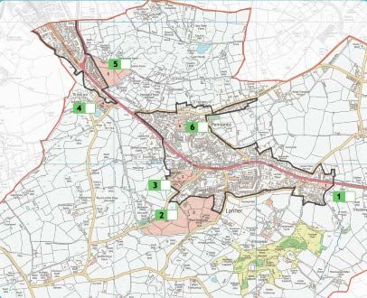
with a stamped addressed envelope for returns and a random draw prize of £50 was
offered to encourage returns of the Household Survey with a £10 draw also being
offered on returns to the Young Persons Survey. At the same time, Cornwall
Council’s Affordable Homes Officer distributed copies of the Housing Needs Survey
to those on the HomeChoice register with a local connection to Lanner, returns being
made direct to the parish council.
8.2 Returns were required to be made by 29 May 2017. Out of the 1259 Household
Surveys issued, 288 responses were received giving a response rate of 22.9%.
8.3 The questions, and the responses were as set out below. In addition, whilst the
questions usually required only a Yes/No answer, the opportunity was provided for
expanded or additional comments. Where these additional comments were either
significant in number (in excess of 5% of total comments received on that question)
or of particular interest or merit, they are indicated below. Note that percentage
figures regarding comments relate to total comments and not to total responses.
8.4 Homes
Q1: Do you agree with the proposed Settlement Boundary (as delineated with a thick
black line on the map below)? Yes – 88%
Q2: Do you agree that sites identified for development should be of quality design
standards that respect local identity? Yes – 96%
Q3: Do you agree maximum protection should be sought for the Tresavean mine
area of the valley? Yes – 94%
Q4: Proposals for outside the Settlement boundary should only be considered if they
are affordable homes led to meet local need? Yes – 90%
Steering Group Comment: These responses are reflected in the draft Plan.
Q5: Residents were asked for their preference with regard to development of the
sites brought forward and identified on the map above.

Site 1: For 10-14 homes with emphasis on quality design, being at the ‘gateway’ to
the village. Yes – 89%
Site 2: This is listed on Cornwall Council’s Strategic Housing Land Availability
Assessment (SHLAA) as having the capacity for 227 homes (175 from 2020-25 and 52
from 2029-30) Yes – 20%
Site 3: Potential for a mixed housing development including one/two bed homes
aimed at those wishing to “downsize” possibly with some sheltered housing and a
car park for users of community buildings. The site is about 4.7 acres. Yes – 74%
Site 4: A small site of about 1.5 acres for affordable home led development. Yes –
83%
Site 5: Another SHLAA site with given capacity for 76 homes 2020-25. Yes – 54%
Site 6: With a now lapsed planning permission for 14 homes, it is possible that a
lower density of development could be required from any new application. Yes –
79%
Steering Group Comment: Sites 1, 3, 4 and 6 will be recommended for development
within the Plan. 2
Site 2 will not be recommended for development. In addition to receiving
overwhelming rejection in the Household Survey, the site is outside the village
settlement boundary, has poor access, would be damaging to the landscape and
environment, and cannot be justified in terms of local need for affordable housing.
Site 5 received a fairly even split in the Household Survey response. Where the
identity of respondents could be identified, of those who support development of
the site 61% live a fair distance away – that is to say, east from the lower part of
Lanner Hill. Of those against the site, 29% live fairly close – that is, from mid-Lanner
Hill west.
Paradoxically, of those supporting the site, 86% support maintaining Carn Marth as
an AGLV; 76% wish to resist further development on the slopes of Carn Marth; and
85% support retaining greenfield land around the Settlement Boundary.
The site is outside the village settlement boundary and cannot be justified on the
basis of local need for affordable housing, it would encroach on the lower slopes of
Carn Marth, it is approached by a private unmade road (Carn Marth Lane) which also
has a dangerous junction with Lanner Hill, and development would appear as an
extension of Redruth to the detriment of maintaining the integrity of Lanner.
Cornwall Council has said it would not be minded to grant a permission on this site.
Consequently, Site 5 is excluded from recommendation within the Plan.
8.5 Heritage
Q6: Residents were asked to nominate significant buildings or structures which they
consider should have recognition of importance if changes are proposed? Those
nominated in significant numbers were:
All Victorian Terraces
Carn Marth Quarry
Christchurch, Rough Street
Figgy Dowdy’s Well
Lanner Churchyard, Rough Street
Lanner Square
Maud Pascoe Memorial, Lanner Square

2
 Site 1 has since received planning consent for five dwellings and has been removed from the draft
Plan. On the advice of Historic England, Site 4 has also been removed as it is an exception site and
therefore, by definition, cannot be in the Plan.
Methodist Church, Rough Street
Methodist Hall, Rough Street
Tresavean Stamps Engine House and arsenic flues
Village Hall, Lanner Hill
Steering Group Comment: Some nominations, such as Pennance Consols (Wheal
Amelia) and Tresavean Trail already have significant protection and have been
therefore excluded from the list: otherwise, the importance of these structures to
the community is noted in the Plan.
8.6 Transport
Q7: Would you like to see a reduction in traffic speed through the village? Yes – 78%
Steering Group Comment: Speed appeared to be a particularly important subject to
residents, with 157 (68%) of respondents providing additional comment. Of these,
24% were content with existing speed limits with another 20% indicating that they
would be content if the existing limits were enforced. 13% of those commenting
desired speed cameras on the main road through the village, particularly average
speed cameras. 10% called for traffic calming measures and 5% for more road
signage. There were also 3 respondents calling for a roundabout at the Coppice Inn.
43% of those providing additional comment to the question were unequivocal in
seeking a reduction in speed limits. The majority of these voices were for a reduction
to 20 mph along the A393 as it runs through the village or at least from the school to
the Lanner Moor playing field. There were also calls to reduce the speed limit along
Sandy Lane to 30 mph; along Pennance Road to 20 mph; to 20 mph on all housing
estates; to 40 mph from Comford to Lanner on the A393 and to 30 mph through
Trevarth hamlet.
Q8: Where would you like to see a pedestrian crossing? The leading response was for
Lanner Square – 43%.
Steering Group Comment: Subsequent to the issue of the Household Survey,
Cornwall Council carried out a pedestrian/vehicle survey at Lanner Square. In
applying a formula to seek justification for a pedestrian crossing, the result was so
far below the minimum required that a crossing is not a possibility. Traffic control
therefore rests with setting the right speed limits and enforcing them.
Q9: Do you think any other location than Site 3 should be considered for a car park?
No – 74%
Q10: Would you be interested in a car-share scheme with other residents? No – 93%.
8.7 Landscape
Q11: Do you agree we should seek to reinforce and support the importance of Carn
Marth as an Area of Great Landscape Value? Yes – 96%.
Q12: Do you agree further development on the slopes of Carn Marth should be
resisted? Yes – 93%
Q13. Do you agree maximum protection should be sought for the Tresavean mine
area of the valley? Yes – 93%
Q14. Do you consider that greenfield land around Settlement boundaries should be
retained? Yes – 93%
8.8 Design
Q15. Should home extensions to the front of the traditional dwelling (other than
modest porches) be discouraged? Yes – 70%
Q16. Should home extensions to the rear of the dwelling be generally supported
provided they are in proportion to plot size? Yes- 97%
Q17. Should loft conversions or ‘upward extensions’ be generally supported? Yes –
89%
Q18. Should a proportion of ‘new builds’ incorporate room-in-the-roof adaptability?
Yes – 90%
Q19. Should all new homes provide a minimum of two parking spaces on site? Yes –
91%
Q20. Should storm water be contained within the site curtilage of new
developments? Yes – 93%
8.9 Leisure
Q21. Do you feel existing open spaces within the village used for recreation should
be retained and protected from development? Yes – 98%
Q22. There appears to be interest in the provision of allotment space near to the
village core. Would you be interested in taking up an allotment if available? No –
84%
8.10 Services and Climate Change
Q25. Would you support community tree planting and, if so where would you
suggest as a location? Yes – 84%
Suggested locations: Entrance to village, Carn Marth, Tresavean, Sandy Lane and
Penstruthal
Q26. Are there any areas in Lanner which you feel do not cope adequately with
surface water run-off? Yes – 62%
Suggested locations: Bell Lane, Lanner Moor, Pennance, Tresavean, Rough Street,
Sandy Lane, Carn Marth, Treviskey
Q27. Do you have reception problems for mobile phones? Yes – 52%
Providers with poor reception: EE, O2, 3Mobile, Vodafone, Giff Gaff, Tesco, Talk
Mobile and BT Mobile
Q28. Would you wish to see a renewable energy farm/plant in the parish?
Those who answered could choose more than one answer.
None – 45%, Wind – 37%, Solar – 25%, Anaerobic – 13%
If the ability to provide more than one answer is discounted, the answer becomes No
– 51% and Yes – 49%.
8.11 Environment
Q29. Do you favour increasing the availability of ‘dog poo’ bins in known ‘hot spots’?
Yes – 66%
Q30. Should we seek a ‘street light curfew’ on residential streets? Yes – 57%
Q31. The area shown as yellow on the map (above) is owned by Cornwall Council.
Should we seek to enhance and improve it as a local nature reserve? Yes – 89%
Q32. Do you consider it acceptable to use covert CCTV in certain areas to catch fly
tipping? Yes – 90%.
Steering Group Comment: All points raised from 8.7 through to 8.11 are included
within the Plan.

9. Housing Needs Survey
Each household had a Housing Needs Survey form sent to it, as did everyone on
Cornwall Council’s Homechoice register who had recorded a local connection to
Lanner. There were 56 written responses indicating an interest in “affordable
homes”.
26 of these were from people who have their own home and have no desire to
move: this despite the form saying “Only return if you feel you need affordable
housing”! The effective response was therefore reduced to 30.
Of these 30, there were then 14 who were obviously not “in need” of affordable
housing or do not require housing for 5 years+. There were further distortions to the
replies: some were clearly filled in by parents for children who may or may not end
up wanting to live locally and others whose local connection is tenuous, their identity
unknown, or their finances indicated as being in excess of £75,000.
Taking a very liberal view there appear to be 16 possible candidates. Half of these
are seemingly in immediate need and half would be ready by the time any
development completed. Looked at another way, about half would be looking for 1
or 2-bedroom properties for retirement/disabled adapted/single person property
and the other half more conventional style. There also seems to be a 50:50 split on
You can also read