Highcliffe and Walkford Neighbourhood Plan
←
→
Page content transcription
If your browser does not render page correctly, please read the page content below
Highcliffe and Walkford Neighbourhood Plan
   In 2028, Highcliffe & Walkford will be a safe, successful, vibrant and attractive place to live, work and visit. Its High Street will be a
     place that people choose to visit and spend their time in. We will have a safe and attractive network of green spaces, cycle and
walking routes which support residents’ physical and mental health and wellbeing. We will remain proud of our Castle, our beaches,
     and the quiet, leafy neighbourhoods that make up much of our parish. New housing will be energy efficient and designed to be
flexible to meet the changing needs of our residents, young and old, and there will continue to be plenty of opportunities for people of
                               all ages to work and socialise and engage in hobbies and activities locally.

2020 - 2028
Highcliffe and Walkford Parish Council
Submission Draft Plan, April 2021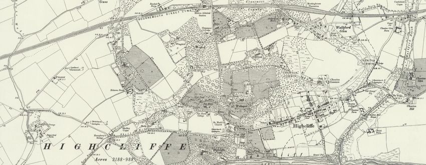
Highcliffe and Walkford Neighbourhood Plan                                  Contents
Contents

  Why is having a Neighbourhood Plan a good idea?                              3
  Key priorities for this plan                                                 3
  Our Vision for Highcliffe and Walkford…                                      5
  Who was involved in preparing the Plan, and what happens next?               6

  National Planning Policy                                                     7
  Local Planning Policy                                                        8

  Improving the High Street environment                                       12
  Retaining a healthy mix of retail and other uses within the High Street     13
  The Local Centres                                                           17

  Local Green Spaces                                                          18
  Green Belt Land                                                             21

  Local walking and cycling routes                                             2
  On-Street Parking                                                            6

  The need for a range of house types                                         12
  Design – practical living spaces                                            14
  Design – built character                                                    16

P a g e |0
Highcliffe and Walkford Neighbourhood Plan                            Contents
Policies and Projects Index

              High Street Improvement Opportunities                     13
              High Street Environment – the Public Realm                13
              High Street Uses                                          16
              High Street Uses                                          16
              Local Centres                                             17

              Local Green Spaces                                        19
              Green Corridors                                           21
              Proposed Green Spaces                                     21
              Increasing Access to Natural Green Spaces                 21

              Walking and cycle routes                                   5
              Walking and Cycling Opportunities                          6
              Parking Standards                                          7
              Parking Restrictions                                       7

              Funding for Community facilities                           9
              Locally Important Community Facilities                    10

              House Types                                               13
              Monitoring changes in the dwelling stock                  14
              Housing design for practical living                       16
              Retaining and Reinforcing Local Character                 24
              Monitoring effective Tree Preservation Order coverage     25

P a g e |1
Highcliffe and Walkford Neighbourhood Plan

1. Your Neighbourhood Plan - Introduction and Background

The area and its population

    Our residents, who number in excess of 13,500 people (2019 mid year estimate), are privileged to live in one of the most beautiful areas of the south, with
immediate access to the coast and in very close proximity to The New Forest. Probably one of the most famous parts of our area is Highcliffe Castle, which sits
proudly in our midst.

     Highcliffe and Walkford parish was formed
following the local government reorganisation in
April 2019, when the new unitary authority of
Bournemouth, Christchurch and Poole (BCP) was
created. The Neighbourhood Plan area (which
covers the entire parish) was formally designated
by BCP Council in December 2020.

     The parish includes the villages of Highcliffe
(historically centred on the High Street (Lymington
Road) to the south, but now covering a much larger
area with the development of land at Hoburne),
Walkford (which is centred on the Ringwood Road
to the north-east) as well as part of the former
Christchurch airfield (to the west) which was
developed for housing and industry following the
runway’s closure in the 1960s. The northern
boundary runs along the London (Waterloo) to                                                                                   Map 1. The Neighbourhood Plan Area
Weymouth railway (there is a station at Hinton Admiral, just to the north of the parish) beyond which is mainly farmland,
and to the south is the coast and English Channel. To the west is Somerford and Friars Cliff, part of the newly formed Christchurch parish, and to the east is the
county boundary, with New Milton and Barton on Sea continuing the strip of coastal development.

 Key facts about our area (Source: 2011 Census)
 Total population: 12,681                                        Average age: 53 years                  Population aged 60 years or more: 50%
 Total housing: 6,636                                            Vacant homes: 7.6%                     Population aged under 30 years old: 21%
 Total area: 639 hectares (2.5 square miles)
P a g e |1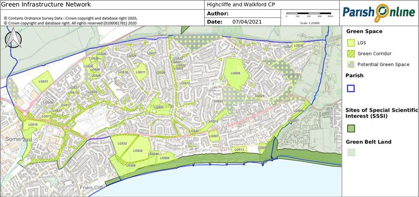
Highcliffe and Walkford Neighbourhood Plan
How the area has developed over time

    At the turn of the twentieth century Highcliffe and Walkford were small villages with a collection of large estates with a principal house, for example, Highcliffe
Castle, Chewton Glen, Hinton Admiral, Wolhayes Estate, Greystones House, Saulfland. The railway and Hinton Admiral Station (opened in 1886) progressively gave
access to the coastline and the area became very attractive for development.

                                                                                                                             Map 9. Historic Map (Ordnance Survey) 1907

    As the twentieth century progressed the majority of estates were sold-off in parcels of land for housing and the character of the area changed considerably.
Relatively low-density development was the norm, with bungalows and chalet bungalows the most common feature of the area built in the 1950s and 1960s. Flats
and apartments, particularly along the coastal fringe with sea views were built in the late 1970 and 1980’s and are a prominent feature of the housing stock. Some
two storey houses (generally 2 to 4-bedroom) complement the ‘mix’.

P a g e |2
Highcliffe and Walkford Neighbourhood Plan
      More recently the Hoburne Farm Estate has been developed with a range of modern family homes. A number of sites have been attractive for redevelopment
notably along Lymington Road in Highcliffe where ‘back land’, behind retail units on the High Street, has provided additional sites for houses and flats. In addition,
‘infill sites’ have been developed replacing single homes with generous garden land.

Why is having a Neighbourhood Plan a good idea?

     Whilst much of the area is now developed (or as in the case of Roeshot, soon to be developed), no place stays still. There will continue to be changes as land and
buildings change hands, and the need for different types of buildings and land use crop up.

     The development plan for the area helps provide the framework for the Local Planning Authority to make decisions about the type of development that is given
permission, and what should be refused, and gives more certainty to landowners, developers and residents about the type of changes that could happen. Up until
now, the Local Plan policies have been set out in the Christchurch and East Dorset Core Strategy (and in part the older Christchurch Local Plan), with these plans
typically prepared by the overarching council for a much wider area. Since 2011, the concept of Neighbourhood Plans has been introduced, and these new
Neighbourhood Plans are prepared by local people, for the area they live in (often based on the parish boundaries, and prepared under the auspices of a Parish
Council). Whilst Neighbourhood Plans cannot deviate significantly from the over-arching strategic policies in the Local Plan, they can make a difference through
more detailed guidance and policies that will shape what is ultimately built. They must reflect the views of local people, as ultimately they are ‘tested’ through a
local referendum.
                                                                                                                    The top priorities for our Neighbourhood Plan
Key priorities for this plan                                                                                             Revitalise the High Street – in particular improving
                                                                                                                         the outdoor areas, traffic management and
      In December 2019, to ‘kick-start’ a Neighbourhood Plan for our area, the Parish Council held an event to           encouraging a better range of shops and services
which a wide range of local groups and businesses were invited. From this event we were able to come up with
a list of possible objectives for our Neighbourhood Plan, which were then tested and ratified through a wider            Look after our green spaces – in particular,
residents’ survey.                                                                                                       enhancing wildlife / natural areas and connecting
                                                                                                                         corridors areas and having good access to the
     The six priorities that emerged from the initial scoping event were generally supported by local people to          beach.
our household survey, although the final one (on carbon neutral design) was perhaps slightly less strongly               Encourage walking and cycling as a way of getting
supported, with the retention of local character a competing priority. These are explained in more detail                about - through the provision of safe cycle routes
below:                                                                                                                   (and cycle rack locations) and improved
                                                                                                                         pavements.
Revitalise the High Street – in particular, improving the outdoor areas, traffic management and
encouraging a better range of shops and services                                                                         Retain and improve our community facilities
                                                                                                                         Encourage a more appropriate mix of housing
     Whilst the local High Street is really valued by our residents, it is clear that it, like many other High Streets
                                                                                                                         types, not just flats.
in the country, is struggling. The Coronavirus pandemic in 2020 has highlighted how fragile some businesses
                                                                                                                         Encourage new building designs to be carbon-
                                                                                                                         neutral.
P a g e |3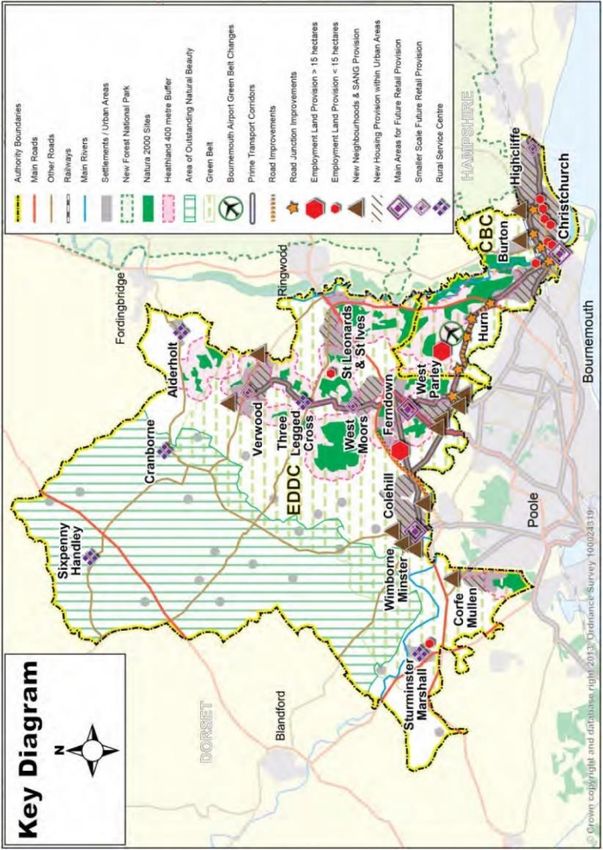
Highcliffe and Walkford Neighbourhood Plan
are – and the Government have stepped in with revisions to legislation to make changes between the various town centre uses (shops, cafes, banks, offices etc) much
easier. The Parish Council have also commissioned Paul Basham Associates (who are Traffic Engineering Consultants) to undertake a 5 stage project encompassing -
Stage 1 – Traffic Flows: baseline study
Stage 2 – Present baseline findings
Stage 3 – Improvement Opportunities Study
Stage 4 – Refine and agree Improvements – budgets and programme
Stage 5 – High Street: enhancement study
This Neighbourhood Plan can perhaps start a useful conversation about the future of Highcliffe High Street, and what changes we particularly want to encourage
to make it more successful and more robust to changes in how people shop and what experiences they want to have when they come to our centre.
Look after our green spaces – in particular, enhancing wildlife / natural areas and connecting corridors areas and having good access to the beach.
Green spaces were very much supported in the responses to the resident’s questionnaire. Retaining and enhancing these spaces is important. so that they can
support the physical and mental wellbeing of the local community – and whilst these are protected in general through the Local Plan policies, this Neighbourhood
Plan can be more definite by designating the most valued spaces as ‘Local Green Spaces’ and where these are not already adequately protected through other
designations. This requires an assessment of all candidate spaces against the national criteria for a Local Green Space. We have also considered whether there are
missing green spaces / corridors that could or should be added, where development opportunities arise.
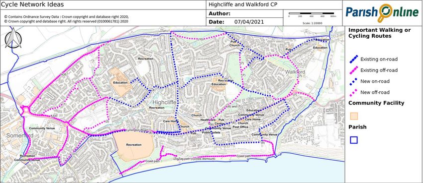
Encourage walking and cycling as a way of getting about - through the provision of safe cycle routes (and cycle rack locations) and improved pavements.
We have collected information from local people about what they perceived to be the key routes – the beach and cliff paths in particular, and also Lymington
Road and Highcliffe High Street, and specific priorities for improvement (and what implications this might have in terms of future plans for the area). The levels of
on-street parking in unsafe locations was the top issue for residents – so we have looked to see how this can be resolved, in part by ensuring new developments do
not add further to these problems.
Retain and improve our community facilities
The household survey helped identify facilities that are particularly valued and should be protected, and also potential needs for new or expanded facilities.
Ideas particularly focused on provision for young families / children and changes that could support and strengthen the High Street, so we have tried to work with a
range of organisations including those supporting young people, to identify what should be the top priorities and how or where these could go.
P a g e |4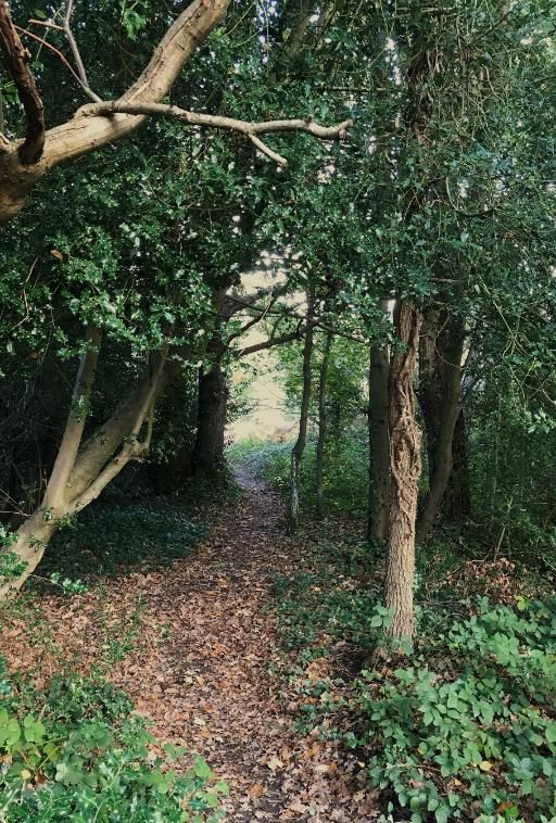
Highcliffe and Walkford Neighbourhood Plan
Encourage a more appropriate mix of housing types, not just flats.

    The main concern appears to be that there is too much focus on building flats in recent years. We have therefore undertaken research based on the available
housing data to provide more locally focused information on housing need. From this, we can provide guidance on the mix of house types and other factors such as
design requirements.

Encourage new building designs to be carbon-neutral
                                                                                      What about other themes and issues?
      The Neighbourhood Plan can encourage the use of more sustainable and            The early scoping session wasn’t limited to just these six themes – the discussions
energy efficient buildings – although minimum standards are generally                 were wide ranging. In terms of transport and mobility a lot of the discussions
covered under the building regulations legislation. It can also make clear that       focused on local bus services – however the frequency and routing of services is
this is a priority over other design considerations. However what was also            not something that can be readily influenced by land use planning, particularly in
clear from the household survey was that there may need to be exceptions              existing built-up areas. Tourism and employment were also discussed. A lot of
where this would result in buildings that differ significantly from the area’s        the discussion on tourism focused on enhanced access to the beaches as a key
local character. So we have provided more guidance in these situations as to          visitor attraction. The main suggestion with regard to employment / industry was
what would and would not be acceptable.                                               the possible provision of incubator units and shared office space for new
                                                                                      businesses. However this idea was not seen as a ‘top priority’ by participants.
Our Vision for Highcliffe and Walkford…

     All of these points have been brought together in the following Vision Statement:

In 2028, Highcliffe & Walkford will be a safe, successful, vibrant and attractive place to live, work and visit. Its High Street will be a place that people choose to visit and
spend their time in. We will have a safe and attractive network of green spaces, cycle and walking routes which support residents’ physical and mental health and
wellbeing. We will remain proud of our Castle, our beaches, and the quiet, leafy neighbourhoods that make up much of our parish. New housing will be energy efficient
and designed to be flexible to meet the changing needs of our residents, young and old, and there will continue to be plenty of opportunities for people of all ages to work
and socialise and engage in hobbies and activities locally.

    The plan period (the time period that the plan will be in effect, unless it is reviewed) mirrors that of the current, adopted plan (which was adopted in 2014 and
runs to 2028). Whilst it could have been extended over a longer period, it is very likely that a review of the plan will take place following the adoption of the new
Bournemouth, Christchurch and Poole Local Plan (which is currently programmed for 2023). The new Local Plan will look at least 15 years ahead.

P a g e |5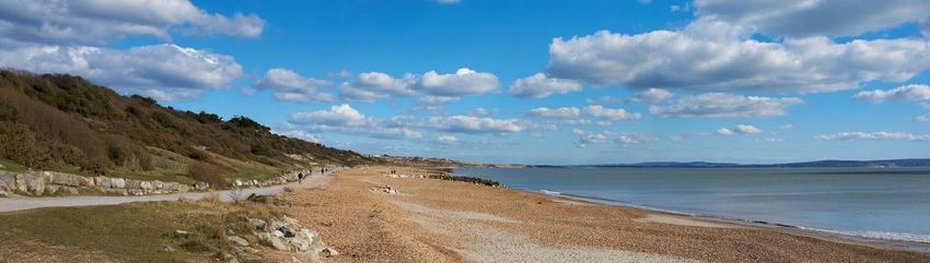
Highcliffe and Walkford Neighbourhood Plan
Who was involved in preparing the Plan, and what happens next?
Shortly after the formation of the Parish Council in May 2019, the Council decided to prepare a Neighbourhood Plan for its area, in order to give the local
community more say in shaping future development in our area. A group of local volunteers and Parish Councillors formed a Sub-Committee together with the
support of a Planning Consultant, Jo Witherden BSc (Hons) DipTP DipUD MRTPI of Dorset Planning Consultant Ltd, to prepare this Plan.
At each stage, as the Neighbourhood Plan has developed, we have consulted with the community. Whilst consulting during 2020 has been difficult because of
the unprecedented lock-downs during the Covid-19 pandemic, the Parish Council and Sub-Committee have used a combination of local contacts, printed and social
media to try to keep local residents and businesses informed and engaged. Whilst the response to the consultations could have been higher (particularly among the
younger age ranges) we feel confident that the responses received broadly reflect the main concerns of our community.
As a result of the feedback from the consultation on the draft plan (sometimes referred to as the pre-submission or Regulation 14 draft), the plan has been
updated. The main issues and changes made are explained in the Consultation Statement. Subject to the Independent Examiner agreeing that it meets the basic
conditions all plans must meet (these are set out in the Localism Act), which may require some further changes, the final plan will then go to Referendum. Local
people (usually those registered to vote in the Neighbourhood Plan area) can then vote as to whether or not Bournemouth, Christchurch and Poole Council should
use the plan (making it part of the development plan for the area). If the majority of those voting say ‘yes’, then these policies will be used in deciding planning
applications, influencing how Highcliffe & Walkford develops in the future.
In addition to the planning policies that will be used in planning decisions, this Plan also contains a number of projects. These are matters which the Parish
Council will look to take forward in partnership with local residents, landowners, developers and other organisations. Where these will require funding, the Parish
Council may use their portion of the Community Infrastructure Levy (CIL) monies due to the parish from development, together with available grants and monies
from the Parish Council’s own precept funds. Once of the first steps for the projects will be to establish the possible timeline, costs and budgets for those projects
that it may lead on.
Thank you to all our residents who have played an active part contributing to the Plan process, Jo Witherden BSc(Hons) DipTP DipUD MRTPI our planning
consultant, as well as the following past and present members of the Sub-Committee:
Cllr Nigel Brooks MBA MRICS Chartered Surveyor
Cllr Willie McNeil BSC (Hons) MSC AIMEE AMIFA
Ian Nichols Project Manager
Ken Tullet MSc CEng
David Underhill Dip Arch RIBA Chartered Architect
P a g e |6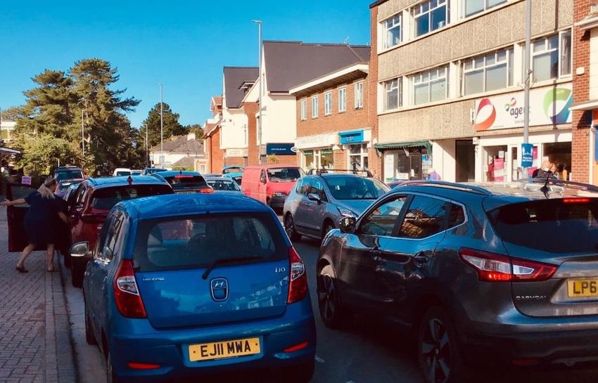
Highcliffe and Walkford Neighbourhood Plan
2. The Local Plan and National Planning Policy– some context
One of the basic conditions that are legally prescribed for a Neighbourhood Plan is that it must have regard to national policy and guidance and be in general
conformity with the strategic policies in the development plan for the local area (which in our case would be the Christchurch and East Dorset Local Plan Part 1 – Core
Strategy). So it is perhaps useful to have a quick overview as to what that means for our area.
National Planning Policy
There are over 50 pages in the 2019 National Planning Policy Framework (NPPF), and a lot more guidance associated with it, which cannot easily be distilled into
one or two paragraphs. But probably one of the most important points is that it explains that the purpose of the planning system as seen by the Government, which
is to contribute to the achievement of sustainable development. It also explains that plans and decisions should apply a “presumption in favour of sustainable
development”, which in our case of plan-making, is to positively seek opportunities to meet the development needs of our area, and be sufficiently flexible to adapt
to rapid change.
The NPPF also makes clear that Neighbourhood Plans should not promote less development than set out in the strategic policies for the area, or undermine
those strategic policies. There is also much more guidance on how plans should help:
Deliver a sufficient supply of homes (whilst protecting Green Belt land)
Build a strong, competitive economy, and ensure the vitality of town centres
Promote healthy and safe communities and sustainable transport
Achieve well-designed places
Meet the challenge of climate change, flooding and coastal change
Conserve and enhance the natural and historic environment
P a g e |7Highcliffe and Walkford Neighbourhood Plan
Local Planning Policy
Christchurch and East Dorset Local Plan
The Local Plan covers a wide area stretching up as far north as Sixpenny Handley in the Cranbourne Chase Area of Outstanding Natural Beauty, and stretching
around the outskirts of the Poole / Bournemouth conurbation as far west as Sturminster Marshall. Highcliffe features a number of times in the Plan, with the High
Street recognised as an important local (district) centre that should be supported (under policies CH4 and CH5), and the importance of Highcliffe Castle in particular
noted as a key historic element (which
alongside the many other Listed Buildings and
Conservation Areas, is protected under policy
HE1). The beaches and coastline is part of the
Highcliffe to Milford Cliffs Site of Special
Scientific Interest (and therefore protected
under Policy ME1). The remaining
undeveloped land is largely protected as
Green Belt (under policy KS3) or as important
open space (under policy HE4). The main
employment areas off The Runway are also
safeguarded (under Policy PC1). Elsewhere
within the built up areas, the potential for infill
and redevelopment is possible and expected,
subject to more detailed design and site
specific constraints.
The main development planned for the
area was the strategic housing allocation on
land south of the railway line at Roeshot Hill
(Policy CN1) which lies partly within the
Neighbourhood Plan area and partly within
Burton parish.
Map 3. The East Dorset and Christchurch
Local Plan Key Diagram
P a g e |8Highcliffe and Walkford Neighbourhood Plan
Map 4. The East Dorset and Christchurch
Core Strategy Policies Map
The Roeshot Hill site was granted outline planning permission in March 2019 (reference 8/16/2932/OUT) for up to 875
dwellings (with up to 35% affordable housing), and will include a local centre (based around the existing Sainsbury’s), two
floodlit all-weather 5 a side sports pitches; a community building with changing facilities, as well as other areas of open space.
Christchurch Local Plan (Review)
Prior to the local government reorganisation, work had starting on the review of the Local Plan, with a first draft of the Christchurch element subject to
consultation in 2017. This did not identify any further land for housing in the Neighbourhood Plan area (and the plan as a whole was unable to meet its objectively
assessed housing needs) other than the potential to release a small area of land in the Hoburne area (south of Lyndhurst Road and immediately west of the Verno
P a g e |9Highcliffe and Walkford Neighbourhood Plan
Conservation Area) which had been previously been identified for playing pitch provision. This land has now been granted outline planning permission for 38 homes,
public open space and landscaping (ref 8/17/0196).
Bournemouth, Christchurch and Poole Local Plan
Whilst the basic conditions do not require a Neighbourhood plan to be in conformity with an emerging plan, it is important that the
emerging evidence is taken into account as it may provide a clear indication how issues are or will change. Work is well underway on
compiling the evidence base for the new plan. Some of the evidence that has been published includes :
BCP Council and Dorset Council Strategic Green Belt Assessment, 2020
BCP Council Strategic Housing Land Availability Assessment, 2019
Bournemouth Christchurch and East Dorset Joint Retail and Leisure Study 2017 (although a further update has been scheduled)
Bournemouth, Dorset and Poole Workspace Strategy and Study, 2016
Level 1 SFRA Report Christchurch Borough Council 2019
South East Dorset Urban Mobility Strategy, 2020
Strategic Flood Risk Assessment, 2019
Additional evidence is still being compiled, and includes the following studies which are anticipated in 2021. As this was not available at the time the
Neighbourhood Plan was agreed for submission and examination, any implications from these reports will be considered through the next review of this Plan.
Housing Needs Study
Local Cycling & Walking Infrastructure Plan (LCWIP) and other studies relevant to the update of the Local Transport Plan
Retail Study update
Urban Potential Study
Viability Assessment of Local Plan / CIL Charging Schedule
At the time of drafting this plan, the Bournemouth, Christchurch and Poole Council had still to produce a first draft of their plan. A total of 206 sites were
promoted across the BCP Council area through the 2019 call for sites. Within Highcliffe & Walkford, six sites have been promoted for development. This includes
industrial land at BAE Systems (The Runway) for a mix of uses, the potential for further housing within the Hoburne Estate, one site at Jesmond Avenue and two sites
within the Greenbelt on Chewton Farm. In addition, six parcels of land on Chewton Common and a further parcel of land at Cranemoor Common have been
promoted for Suitable Alternative Natural Greenspace (SANG). All these sites are currently being assessed as part of the preparation of the BCP Local Plan, and the
next scheduled stage of the BCP Local Plan will be the Issues and Options Consultation, expected to be published for consultation in Summer 2021.
It is likely that this Neighbourhood Plan will need to be reviewed following the adoption of the new Local Plan, in order to resolve any conflicts that may arise.
P a g e | 10Highcliffe and Walkford Neighbourhood Plan
3. The High Street
Highcliffe’s High Street is what is known as a ‘district centre’. This means it has a reasonably good range of shops and services serving the local population.
There is Tesco express, a Co-operative Food store, and over 100 other town centre type businesses, local attractions and hospitality venues on this stretch of road.
High Streets across the UK are struggling, and even more so as a result of the Covid-19
pandemic in 2020. Revitalising the High Street was one of the top priorities for local Strengths Weaknesses
people (see the results of our household survey). The main comments received related to • Convenient public car parks close • Limited food and grocery
the mix of uses (too many charity shops, not enough cafes and restaurants) and the issues to the centre. shopping, and evening / leisure
with traffic and run-down feel of the street environment. This is echoed in the 2017 retail
• Range of independent specialist uses (and mainly low market
report, commissioned at that time by Bournemouth Borough Council and Christchurch comparison goods stores).
shops.
and East Dorset Councils. A survey of the High Street in Summer 2020 recorded
• Good quality eateries. • Busy main road detracts from the
approximately two-fifths (40%) of units as retail outlets (primarily convenience), a further
overall shopping experience.
15% professional or financial services, and just under 10% as pubs / restaurants / cafes /
takeaways. Just over 6% were healthcare and medical services and most of the remaining Opportunities Threats
fell outside the recognised use classes, with a significant number of these being beauty
• Improvements to the public • Increased vacancies / lack of
salons or similar services. Some 15% of the units were vacant – including premises
realm and pedestrian environment demand from town centre investors
vacated by two of three three High Street banks (the third having also closed and replaced
may increase visitors to the area. • Increased traffic through the
by a betting office) and the closure of the long-established G&Ts discount store.
• expanding the evening economy. centre.
The report recognised that Highcliffe is not a main destination for food or non-food
shopping, and has a very limited leisure role and comparatively limited public realm – in terms of open space and street furniture. Its shops are mainly small
independent traders, with a relatively high concentration of local service outlets and a low level of restaurants and hot food takeaways, compared to other centres. A
lot of the shop units are small (under 150m²), which means that they tend to be attractive to start-up businesses, but as a consequence the turnover of users can be
high as the businesses grow or fail. The retail study noted that the main road creates a barrier for pedestrians. On the positive side, the public car parking is
convenient, and the vacancy levels were no higher than average.
The 2014 Local Plan’s proposals for Highcliffe are based the High Street continuing to be a thriving and busy centre for the local population and visitors. Key
factors to this success were seen as:
enhancing the niche retail offer to attract more visitors with unique / specialist shops;
encouraging the evening economy;
encouraging community services such as healthcare and sports / leisure facilities;
creating better linkages between the centre and the beach, so that visitors to the beach will benefit local trade;
improving the outdoor areas to create a more welcoming and pedestrian friendly environment;
maintaining sufficient parking provision to service the centre.
P a g e | 11Highcliffe and Walkford Neighbourhood Plan
Improving the High Street environment
The High Street is dominated by the A337 main road (which is a strategic transport route
and typically has between 16,000-30,000 vehicles using it in any day) and varies in width
between some 9m to 6.2m). Whilst there is a large car park (Wortley Road car park)
conveniently located to the south side, many people use the on-street parking as it is
convenient and free (although restricted to 30 minutes) with vehicles consequently waiting to
get into or out of spaces. The pavement areas are a mis-match of surfaces and somewhat
cluttered by street furniture, signage and bins. A number of side-roads create further disruption
to both pedestrian and the flow of vehicles.
In March 2020, Highcliffe and Walkford Parish Council commissioned Paul Basham
Associates Ltd to produce a High Street Enhancement Study. The first stage report (looking at
potential opportunities) has now been produced. The report focuses on what could be changed
to make the High Street a more pleasant place for local residents and visitors alike. The initial Our main objectives:
report produced in August 2020 concludes with a number of ideas, which are summarised
− More spacious pavements, with fewer trip and bump hazards
below:
− Designed for pedestrians
Remove central white lining and include other related measures to support a 20mph − Slower traffic, safer for cyclists (as a dedicated cycle lane
speed limit along the High Street cannot easily be achieved)
Replace the signalised pedestrian crossings with zebra crossings (subject to more
detailed design checks) to increase the ease and safety for pedestrians crossing the
High Street
Remove all on-street and layby parking from the High Street– except for a small
number of disabled bays
Increase the amount of pedestrian / footway space (particularly on the sunnier,
northern side of the carriageway) by reducing the road width to 6m wide (except at the
crossroads where turning lanes are provided) – this is marginally higher than the 5.5m
minimum width for two HGVs to pass.
Create a gateway entrance feature with planting at either end of the High Street
Create additional cycle parking areas
Include ‘charging points’ in Wortley Road car park and re-look at charging to balance
any impacts from the loss of parking on the High Street (e.g. some free 30 minute
parking spaces)
P a g e | 12Highcliffe and Walkford Neighbourhood Plan
The potential to reduce the number of heavy goods vehicles, for example by introducing a weight limit restriction, or advanced traffic signage warning HGV's to
avoid Lymington Road at certain times was considered. However such restrictions are difficult to enforce and the Highways Authority would be reluctant to
introduce such restrictions on A-class roads (particularly given that it is the identified priority route for HGVs travelling between Christchurch and Hampshire). The
signing of more suitable alternative routes could help but would need to be done in conjunction with the Highways Authority and Police. Other changes to the wider
road network may also help, for example improvements to the Cat & Fiddle junction where Ringwood Road meets the A35 (Lyndhurst Road) could reduce the amount
of motorists that deviate to avoid due to the tail-backs caused by cars coming from Walkford waiting to turn right.
Most of this work would take place within the highway, and not require planning permission. On this basis we have included these potential improvements as a
project – which can be funded from the Community Infrastructure Levy (CIL) monies due to the parish from development, Bournemouth, Christchurch and Poole
Council and Central Government grants and the Parish Council’s own precept funds. The timescales for implementation will depend on a wide range of factors – for
example, the removal of white lines is best done when roads are re-surfaced – and further consultations on the detailed implementation will take place as the project
progresses. We have also included a policy in our Neighbourhood Plan to complement the changes being made and emphasise support for improvements to the
public realm which may be possible if and when landowners undertake wholescale redevelopment of sites fronting onto the High Street.
High Street Improvement Opportunities High Street Environment – the Public Realm
The Parish Council will work with Bournemouth, Christchurch and Poole Proposals to increase the extent of, or improve the quality of, the public realm within
Council, local landowners and retailers to implement the improvement the High Street will be supported.
opportunities highlighted through the Highcliffe High Street Improvement Any major redevelopment schemes fronting onto the High Street should seek to
Opportunities Study (2020) taking into account the issues and priorities improve the High Street environment for pedestrians through the careful consideration
identified through ongoing consultation. of setback, scale and route connections.
Retaining a healthy mix of retail and other uses within the High Street We are fortunate to have two national food stores
(Tesco and Co-op) plus independent stores such as
Whilst it is perhaps too soon to be able to predict the full impact of Brexit and the Covid-19 our local bakery, butchers and furniture shop.
pandemic on the High Street, it is clear that nationally more retailers are facing closure with the impact Market forces will dictate how many of the
of Covid-19 the ‘last straw’. The Centre for Retail Research (CRR) has predicted that there will be more existing retail businesses will survive the pressures
than 20,000 store closures nationally by the end of 2020 (compared to 16,000 in 2019). However all is not on all High Streets. But by making the High Street
necessarily doom and gloom; possible trends and opportunities predicted by some retail experts include more appealing for people to visit, other
the potential that customers are more likely to shop local, the increasing popularity of local ‘click and businesses will look to relocate and invest here.
collect’ options linked to online retail, and a higher demand for al fresco dining. For these reasons, it is important that the core
part of the High Street should continue to have a
retail / community focus.
P a g e | 13Highcliffe and Walkford Neighbourhood Plan
The Old and New Use Classes
Previously most town centre uses fell within a range of different
classes, with retail shops (A1) distinct from financial / professional
services such as banks and estate agents (A2), cafes and restaurants
(A3), pubs (A4) and hot food takeaways (A5). Other uses that might
typically be found in a High Street could include assembly and leisure
uses such as community halls and sports gyms (D2) as well as a range
of social / cultural and health-related uses such as libraries and
medical centres (many of which would fall within the D1 use class).
Whilst residential uses are commonly found above retail and other
units, hotels (C3) are also a common feature of many town centres.
The new classes:
In July 2020 the Government reacted to the issues facing Britain’s High Streets by Use Class E - ‘commercial, business and service’ uses. Under the new
creating a more flexible environment for operators. This was done through an overhaul to system, shops (A1), financial and professional services (A2),
what is known as the Use Classes Order, which defines what category different types of restaurants and cafes (A3) and office / light industrial workshops (B1)
uses fall into. The Government created a new commercial, business and service use class use classes, and uses such as indoor gyms, day nurseries and health
that covers most town centre uses, along with two other new use classes (see the centres (some D1 / D2) will fall within this new use class.
information box for more detail). This is particularly significant as changes within a single
Use Class F1 – ‘learning and non-residential institutions’.
use class are not considered to be ‘development’ and do not require planning permission,
Incorporates former D1 uses which are more likely to involve buildings
so there will be less restrictions on changes between retail (shops) and other uses on the
which are regularly in wider public use such as schools, libraries, art
High Street. It is estimated that about two-thirds of the units in the High Street would fall
galleries, museums, public halls, churches and law courts.
within the new Class E commercial, business and service’ uses. This means that these
premises will have much more flexibility in terms of changes within that use class. Use Class F2 – ‘local community’. Groups together uses from the
former D2 uses which provide for group activities of a more physical
The Government can also specify whether a change between one class to another is nature – swimming pools, skating rinks and areas for outdoor sports.
permitted development (which also means that is does not require planning permission). It also includes the use of buildings where this is principally by the
There is a transitional arrangement dealing with the ‘old’ uses which will finish in July local community eg community halls, and local shops (which are small
2021, and by that time a further update to Permitted Development Rights is expected. scale and the only such venue within 1000m radius).
A further change has been made to the General Permitted Development Order in ‘Sui generis’ - pubs and hot food takeaways, cinemas, concert, dance
March 2021, enabling potential changes from the new Class E to residential, subject to and bingo halls will no longer be included in any use class. Nail bars,
certain limitations such as size and impacts of noise from commercial premises on the beauty salons, taxi hire firms and betting shops will also remain
intended occupiers of the development, where premises have remained vacant for a classed as sui generis.
P a g e | 14Highcliffe and Walkford Neighbourhood Plan
continuous period of at least 3 months. Such changes will be subject to prior approval by BCP Council, and it will be important to monitor the impact this new
flexibility will have on our High Street and neighbourhood centre. Changes to and from pubs or hot food takeaways will continue to be subject to planning, and the
potential loss of community halls and key public services (such as the health centre and library) would also be restricted.
Map 5. Highcliffe High Street
Planning policies often talk about the ‘town centre area’, ‘primary shopping areas’ (where most of the shops are found) and ‘secondary shopping areas’ which
might typically have a wider mix of uses. These are useful in clarifying where town centre policies apply, and what changes may or may not be acceptable. The Local
Plan defined the primary shopping area in 2014, covering the area of the High Street from just past the Premier Inn up to the crossroads where G&Ts Warehouse used
to be. A secondary area was also defined going further east to include the parade of shop units stretching as far as Seaton Road. The aim of the policies was to retain
P a g e | 15Highcliffe and Walkford Neighbourhood Plan
a sufficient level of retail and other town centre uses in the centre, and to resist changes from retail to other town centre uses within the primary shopping area (west
of the crossroads), particularly where this would result in a row of three or more non-retail units or result in the number of ground floor retail units falling below 70%.
Whilst the Local Plan’s vision for the High Street (as contained in Policy CH4) remains relevant, the loss of retail since 2014 (dropping to about 50% in 2017
according to the Council’s land use survey) and changes to the use classes have made some of the related retail planning policies in the Local Plan out of date. The
following policy therefore has been drafted to provide clarify on the range of uses that would be supported. It reflects that there needs to be flexibility to
accommodate both larger and smaller store needs, and ties in with the push to improve the public realm to make the whole centre an inviting experience.
Minor changes to the boundary have been incorporated to reflect the staggered nature or residential and town centre uses at either end, drawing the boundary
in to where there are town centre uses on either side. This does not preclude the continuation of town centre uses just outside the boundaries, but reflects that the
centre may ‘flex’ over the coming years and the loss of town centre units on these margins is less critical than the concentration in the central stretch. Residential
units to the rear have been excluded from the boundary, and the main car park has been included as it is an important facility for the centre.
High Street Uses
The use of ground floor units within the High Street area (shown on Map 5) should fall within one or more of the following (and may include a mix of uses within these
categories):
• Use Class E - commercial, business and service uses
• Use Class F1 – learning and non-residential institutions
• Use Class F.2 – local community uses
• Use Class C1 – hotels and guest houses
• Pubs, hot food takeaways, leisure venues (such as theatres, cinemas, concert halls, live-music performance venues, bingo halls and dance halls) and other
main town centre uses (as defined in the NPPF) – subject to ensuring that the amenities of the local residents are not adversely affected by noise or
disturbance
The provision of ‘click and collect’ facilities, an outdoor market / areas for outdoor events and al fresco dining should be supported, subject to ensuring that the
amenities of the local residents are not adversely affected by noise or disturbance. Whilst residential uses on upper storeys is encouraged, ground floor residential
uses will not be supported.
The amalgamation or subdivision of units to allow the creation of larger or multiple smaller premises is supported. Any physical changes should retain (or where
absent., create) shopfront entrances and openings so people can access the building from the street and so that the buildings appear connected with, and provide
interest to, the street. Land off Wortley Road will continue to serve the centre as its main public car park.
High Street Uses
The Parish Council will work with BCP Council to monitor the mix of town centre and residential uses within the High Street and Local Centres in light of the greater
flexibilities introduced through Permitted Development Rights, and will identify and agree actions if the vitality of these centres notably declines.
P a g e | 16Highcliffe and Walkford Neighbourhood Plan
The Local Centres
In addition to the High Street, there are two
other local centres that continue to provide local
services for the community. These are the parade
of shops on Ringwood Road in Walkford, and the
small parade in Saufland Place near Hoburne Park.
For residents at the westernmost end of the parish,
the Sainsbury’s superstore is in walking distance
and this may be further supplemented by the local
centre planned as part of the Roeshot
development (although further retail outlets are
not currently proposed as part of the outline
consent). The local centre at Lakeland Road was (a) Saufland Road Local Centre
converted to residential in the mid 2010s, as it had
(b) Ringwood Road Local
not proved an attractive location for businesses
Centre,
(having little passing trade in that location).
Walkford
These two local centres are protected through
the adopted Local Plan policies, but we have taken
the opportunity to modify the boundaries slightly
to more accurately reflect the reality on the ground
and clarify that the boundary would not preclude
these areas from expanding if this would meet a
local need.
Map 6. (a and b) The Local
Neighbourhood Centres
Local Centres
The local shopping areas in Ringwood Road and Saufland Road are shown on Map 6 (a and b). Proposed improvements to the provision of shops and/or services
which provide for people’s day to day needs will be supported within and adjoining these centres, subject to ensuring that the amenities of local residents are not
adversely affected by noise or disturbance.
P a g e | 17Highcliffe and Walkford Neighbourhood Plan
4. Our Green Spaces
Looking after our green spaces was the objective that was most highly supported in responses to the
household survey. There were nearly 500 suggestions to the question asking for examples of local green spaces
that people valued. Whilst some of these were outside of our Neighbourhood Plan area – such as Mudeford Quay
and Avon Beach, Stanpit Marsh, Hengistbury Head, Burton Common and the New Forest – we have focused on
assessing spaces within our area to see which might be eligible to be designated as a Local Green Space.
Local Green Spaces and Green Corridors
Local Green Spaces were first introduced nationally as a concept in 2012. These were defined in national
planning policy, as spaces that local communities could identify for special protection (where new development is
ruled out other than in very special circumstances). In order to qualify for the designation, it is important to
demonstrate that the green space:
is in reasonably close proximity to the community it serves;
is demonstrably special to a local community and holds a particular local significance, for example because of
its beauty, historic significance, recreational value (including as a playing field), tranquillity or richness of its
wildlife;
is local in character and is not an extensive tract of land;
is not already consented for development (i.e. no existing planning consents or allocations in the development
plan that could come forward) and is likely to endure beyond the plan period (i.e. there is not likely to be a
reason why the green space would no longer be valued and could be developed at a future date);
and that the landowner has been made aware of the proposal to designate their land (and any objections
they may have, considered)
The Neighbourhood Plan Group has therefore looked at all the spaces put forward for consideration, and also
those spaces identified through previous studies (such as the Christchurch Borough-wide Character Assessment in
2003 and the Open Space, Sport and Recreation Assessment in 2008) to see which would be eligible and would
benefit from Local Green Space designation. The summary table of the proposed Local Green Spaces as assessed is
included in Appendix 1. The table also explains the main reason for each spaces’ designation.
We consulted with local residents in the latter part of 2020 to check whether we had correctly identified those
spaces that they valued. This indicated that the vast majority of local residents value all of the areas proposed to be
P a g e | 18Highcliffe and Walkford Neighbourhood Plan
designated as Local Green Spaces, and generally the more local, the higher the level of support (with at least 90% Local Green Spaces in the Parish
of those responding to the survey valuing all the spaces in their locality). Highcliffe beaches (SSSI)
The coast and cliffs have not been designated specifically as a Local Green Space. This is not because they are Cliff top / cliff paths (SSSI)
of no value – the opposite is true - they were the top feature mentioned in the consultation as being particularly LGS03 Nea Meadows LNR
valued. However they are too extensive in size to qualify as a Local Green Space, and in any event lie within the LGS04/b Highcliffe Castle grounds
Highcliffe to Milford Cliffs SSSI. This means that they are recognised as a nationally important site (mainly for their LGS05/b Chewton Bunny
geological interest (in particular the fossils), but also the plants and wildlife (including a range of invertebrates) LGS06 Steamer Point LNR
that they support. On this basis there is considered to be sufficient protection. A number of sites have overlapping LGS07 Highcliffe Recreation Ground
local designations, but the Parish Council consider that their designation as a Local Green Space is warranted to LGS08 Chewton Common
provide a clear and continuing policy basis for their protection. LGS09 Cliffhanger
LGS10 Lakewood
Both the Wallkford and Roeshot allotments have been included in the list of Local Green Spaces. The adopted
Local Plan includes the Roeshot allotments within the strategic allocation for housing, but on the basis that the LGS11 Wingfields Recreation Ground
existing allotments can be relocated to a larger 'hub site' contributing towards current unmet need and future LGS12 Jesmond Avenue woodland
requirements across the wider area. In general, it is expected that such provision is made within three-quarters of LGS13 Wharncliffe Road grassed area
a mile of the existing allotment site and easily accessible – and there are very few large, undeveloped areas that LGS15 Mudeford Wood
could readily meet this criteria and a clear need for continued allotment provision. Whilst it is accepted that at LGS16 Mudeford Wood Recreation Grounds
present this site is intended to contribute to the adopted Local Plan housing target, there appears to be an LGS17 Green spaces off Saffron Drive
impasse on its deliverability, and the Parish Council (who own the allotment site) have no intention of relocating LGS18 Woodfield Gardens
the allotments and fully support their designation as a Local Green Space. LGS19 Bellflower Close Play Area
LGS20 St Marks Cemetery
Whilst the Local Green Spaces have been used to identify those spaces that hold a particular significance to
the local community, the “green corridor” elements of many parts of the built-up areas are collectively important. LGS21 Hurst Close
This includes generous highway verges, site boundaries where there is a significant band of mature trees, and LGS22 Oakwood Road / Latimer Close greens
areas that form part of the landscaped corridors in residential estates. The trees and green spaces make a major LGS23 Haslemere Avenue
contribution to the character of many parts of the parish, and support local wildlife by providing habitats running LGS24 Bramble Lane Copse
through the area. The policy seeks to protect the landscape benefits and wildlife function of these green corridors LGS25 Hoburne Brook
and avoid the unnecessary loss of mature trees and, and encourages their extension to create greater connectivity, LGS26 Hoburne Farm Estate / Verno Lane
landscape and wildlife benefits. Within highway verges, the placement and design of any necessary highway LGS27 Woodhayes Avenue
improvements should be considered to find the most appropriate solution. LGS28 Ashmore Grove
LGS29 The Meadway
Local Green Spaces
LGS30 Walkford allotments
The areas shown on Local Green Spaces (LGS) on Map 7 are designated for the strongest protection. Development LGS31 Roeshot Hill Allotments
within these areas will not be permitted other than in very special circumstances, and development proposals LGS32 Highcliffe Castle Golf Course
P a g e | 19Highcliffe and Walkford Neighbourhood Plan
within or adjacent to these area must not undermine the reason for that space’s designation as listed in Appendix 1. Development that would positively enhance the
beneficial use of these spaces, such as to provide improved access or to allow opportunities for outdoor sport and recreation, to retain and enhance landscapes,
visual amenity and biodiversity, will be supported.
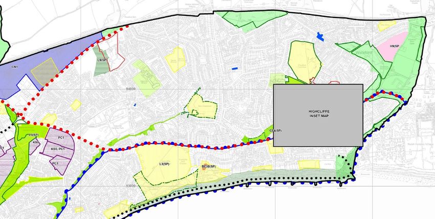
Map 7. Green Infrastructure Network
P a g e | 20Highcliffe and Walkford Neighbourhood Plan
Green Corridors
The Green Corridors (as shown on Map 7) are to be retained, and opportunities should be taken, where practical, to:
• enhance tree cover;
• enhance biodiversity through the linking of habitats, and
• provide opportunities for the informal enjoyment of these spaces where they form part of the public realm.
Development proposals adjacent to a green corridor will be expected to respect its function and integrity.
The Green Infrastructure Network map also indicates a number of larger, proposed accessible green spaces. These
include an area within the Roeshot strategic allocation that is shown on the site masterplan as providing the main area of
amenity space (in line with the policy requirement for a central green space linking to the countryside in the north and
southwards along the Mude Valley to the coast), and an area to the east side of the latest phase of the Hoburne Farm
Estate development (as shown on the outline planning application). Cranemoor Common and Woods and much of
Chewton Common (which is registered commonland) are also shown as proposed accessible green spaces, in those areas
where it is largely inaccessible. The major landowner (Meyrick Estate) is proposing that these areas are more positively
managed as part of the green infrastructure network in the parish (to provide alternative sites for access to natural
greenspace in order to reduce recreational pressure on the more sensitive heathland sites in the area), and our resident
consultation showed significant support for this proposal, although there were a number of comments suggesting that this
would need to be done in a manner that would not reduce the biodiversity of the many unmanaged areas (through inconsiderate management or disturbance),
particularly given their role as part of the wider network of green corridors.
Proposed Accessible Green Spaces Increasing Access to Natural Green Spaces
The proposed accessible green spaces as indicated on Map 7 are identified to The Parish Council will work with Meyrick Estate in developing management
provide additional publicly accessible green spaces. They should remain plans for the areas within their ownership proposed as Suitable Alternative
largely undeveloped and be managed to both allow recreational access (for Natural Greenspaces.
example, the inclusion of paths and seating) and support and enhance the
area’s tree cover and biodiversity as part of the network of Green Corridors.
Green Belt Land
Cranemoor Common and Woods, parts of Chewton Common, Chewton Bunny and land to the east side of Chewton Farm Road are all with the Bournemouth,
Christchurch and Poole Green Belt. Any changes to the extent of the Green Belt is a strategic matter for the Local Plan. BCP Council undertook a Green Belt study in
2020 to assess the extent to which each parcel of land contributes to the main functions of the Green Belt. Within the Neighbourhood Plan area, the Green Belt areas
are particularly important in terms of retaining the separation of Highcliffe and Walkford from New Milton, and safeguarding the countryside from encroachment.
The Parish Council supports their continued Green Belt status.
P a g e | 21Highcliffe and Walkford Neighbourhood Plan
5. Local routes – walking, cycling and on-street parking
Feedback obtained through our household survey showed that much of the area is well used by walkers. The beach and cliff paths are particularly well used, as
well as the associated links through to the built-up area, such as along Chewton Bunny, as well as Chewton Common and Nea Meadow.
Local residents walk for recreation and to access facilities (such as going to school or to the library). And our residents survey suggests that the majority of
people own bicycles (even the majority of those in late 60s and early 70s), although travel surveys suggest that far fewer use them on a weekly basis. The “Beryl
bikes”hire scheme was set up in Bournemouth and Poole in the summer of 2019, and extended to Highcliffe
and Walkford in late 2020, meaning that most residents are now within a five-minute walking distance of a
‘Beryl Bay’. Short trips can be easily made on foot or bicycle if the right infrastructure is in place, helping to
improve public health and air quality whilst also reducing local congestion and carbon emissions. It is
important that the routes they use are safe and attractive otherwise people may be tempted to use their car
instead. Cycling is another form of transport that is healthy and good for short trips, but there is little bespoke
provision for the cyclist in Highcliffe, with most users having to share the roads with cars and other traffic.
Local walking and cycling routes
Highcliffe is well served for recreational walking and much of the area is well used for this purpose. There
are a number of green spaces in the parish which are easily accessed for recreational walking, and even the
neighbourhood roads themselves can provide an interesting stroll with a mix of (largely modern) housing
types, as well as being routes used to get to the High Street and other local facilities.
Walking
Of particular merit and note for recreational walking are the nature reserves at Nea Meadows and
Chewton Bunny, and the cliff and coastal area (including the beach specifically) from Chewton Bunny to Friars’
Cliff through Steamer Point LNR. It is anticipated that the South West Coast Path will run along the coast
through Highcliffe and up Chewton Bunny, when this route is confirmed. The Highcliffe Action Team
produced, in 2019, an attractive guide to a four mile trail of nature and history in a Highcliffe Visitors’ guide. A
number of alternative short circular walks are also promoted by the former Borough Council https://www.christchurch.gov.uk/sport-leisure/walking/walking-routes-
and-trails.aspx. Access to some areas is unclear and better signage may help. For some residents and visitors, reaching the main green spaces for recreation is not
easily achieved on foot. To this end, there is a large car park at the eastern end of the beach (at the Cliff-hanger) and limited provision at Highcliffe Castle at the
western end.
P a g e |2You can also read