West Cumbria Coastal Plain - National Character Area profile: Natural England publications
←
→
Page content transcription
If your browser does not render page correctly, please read the page content below
National Character      7. West Cumbria Coastal Plain
      Area profile:                                                                        Supporting documents

                                                                               Key facts      Landscape           Analysis
                        Introduction & Summary   Description   Opportunities
                                                                               and data       change

  www.naturalengland.org.uk

                                                                                                     1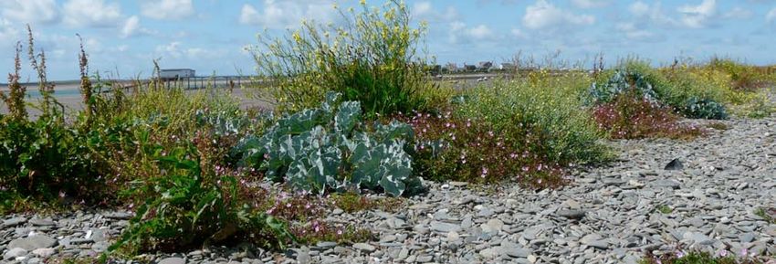
National Character                7. West Cumbria Coastal Plain
      Area profile:                                                                                                                                   Supporting documents

                                                                                                                                      Key facts             Landscape              Analysis
                                  Introduction & Summary         Description                     Opportunities
                                                                                                                                      and data              change

   Introduction                                                                          National Character Areas map
   As part of Natural England’s responsibilities as set out in the Natural
   Environment White Paper,1 Biodiversity 20202 and the European Landscape
   Convention,3 we are revising profiles for England’s 159 National Character Areas                                                               North
   (NCAs). These are areas that share similar landscape characteristics, and which                                                                 East
   follow natural lines in the landscape rather than administrative boundaries,
   making them a good decision-making framework for the natural environment.                                                                           Yorkshire
                                                                                                                                                         & The
                                                                                                                                            North       Humber
   NCA profiles are guidance documents which can help communities to inform
                                                                                                                                            West
   their decision-making about the places that they live in and care for. The
   information they contain will support the planning of conservation initiatives at a                                                                       East
   landscape scale, inform the delivery of Nature Improvement Areas and encourage                                                                          Midlands
   broader partnership working through Local Nature Partnerships. The profiles will                                                           West
   also help to inform choices about how land is managed and can change.                                                                     Midlands
                                                                                                                                                                         East of
   Each profile includes a description of the natural and cultural features                                                                                             England
   that shape our landscapes, how the landscape has changed over time,
   the current key drivers for ongoing change, and a broad analysis of each                                                                                        London
   area’s characteristics and ecosystem services. Statements of Environmental
                                                                                                                                                             South East
   Opportunity (SEOs) are suggested, which draw on this integrated information.                                                    South West
   The SEOs offer guidance on the critical issues, which could help to achieve
   sustainable growth and a more secure environmental future.

   NCA profiles are working documents which draw on current evidence and
   knowledge. We will aim to refresh and update them periodically as new                 1
                                                                                           The Natural Choice: Securing the Value of Nature, Defra
   information becomes available to us.                                                    (2011; URL: www.official-documents.gov.uk/document/cm80/8082/8082.pdf)
                                                                                         2
                                                                                           Biodiversity 2020: A Strategy for England’s Wildlife and Ecosystem Services, Defra
                                                                                           (2011; URL: www.defra.gov.uk/publications/files/pb13583-biodiversity-strategy-2020-111111.pdf)
   We would like to hear how useful the NCA profiles are to you. You can contact the     3
                                                                                           European Landscape Convention, Council of Europe
   NCA team by emailingncaprofiles@naturalengland.org.uk.                                  (2000; URL: http://conventions.coe.int/Treaty/en/Treaties/Html/176.htm)

                                                                                                                                                                    2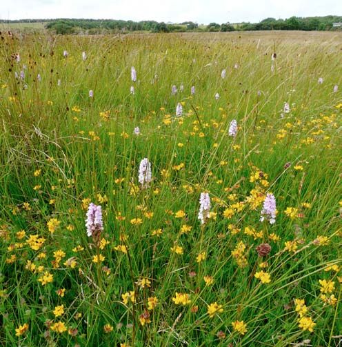
National Character 7. West Cumbria Coastal Plain
Area profile: Supporting documents
Key facts Landscape Analysis
Introduction & Summary Description Opportunities
and data change
Summary internationally protected lowland rivers in the form of the Ehen and Derwent
and lowland raised bogs around the Duddon Estuary.
The West Cumbria Coastal Plain National Character Area (NCA) forms a plain In the north, access by road historically follows the Roman routes through
of varying width between the Cumbrian High Fells NCA in the east and the the Derwent Valley and along the margins of the Solway Basin. In contrast,
Irish Sea to the west. Views inland are set against the Lake District mountains, the southern route via Furness and Barrow is more recent, being 19th century
with long-distance views to the Isle of Man and southern Scotland across in origin, with earlier routes being across the sands of Morecambe Bay. The
the sea. The coastline encompasses a diverse range of habitats including railway, also of 19th-century origin, follows the coastal periphery and links all
mudflats, shingle and pebble beaches, honeycomb worm reefs, soft cliffs, the main coastal settlements.
the high sandstone cliffs of St Bees, dune systems, expansive estuarine
systems and the barrier islands of Walney and Foulney. The area has a diverse economy historically based on coal mining, open cast
mining, ship-building and agriculture, with the developing and expanding energy
Inland the wind-swept and open pastoral farmland of the undulating plain industries and tourism being important employers and adding to development
is dissected by more sheltered lowland river valleys. These valleys are pressures. Tranquillity as well as a strong sense of place and history all contribute
delineated by woodland and grade into coastal landscapes as they approach to the area’s recreational value which, combined with its nature conservation
the sea. The arable landscape of the St Bees area provides a contrast with the interests associated with the rivers and the coast and strongly influenced by
surrounding pastoral landscape. A large part of the area is designated as part water quality, makes the area attractive
Solway 6
National Character Area 7
of the Lake District National Park. To the north there are extensive areas of to both residents and visitors. The West Coast Solway
Basin
West Cumbria
land reclaimed from coal mining, iron and steel industries, and processing Cumbria Coastal Plain NCA provides the Coastal Plain
Note: In most instances, the NCA boundary is not
precisely mapped and should be considered as a
industries around the towns/ports of Whitehaven, Workington and Maryport. access gateway to the western fells and
zone of transition between NCAs.
9
Eden
The energy industry is highly visible and an important employer, with ship- lakes of the Lake District National Park Valley
8
building important around Barrow-in-Furness in the south. for those seeking quiet recreational Lake
Cumbria
High Fells
experiences. The St Bees Heritage Coast, District
The coast from Walney Island to St Bees, including the Duddon Estuary and Hadrian’s Wall World Heritage Site and
the estuary complex at Ravenglass, has a number of internationally and Hadrian’s Cycleway (part of the National 19
South Cumbria
nationally designated nature conservation sites. These are important for their Cycle Network), and the Coast to Coast Low Fells
coastal sand dune, vegetated shingle and salt marsh communities as well as path and England Coast Path all cross 20
for breeding seabirds, wintering waders and wildfowl, natterjack toad and the NCA, bringing visitors to experience
NCA 7 boundary Morecambe
Click map to enlarge; click again toLimestones
Other NCA boundary
Area outside NCA 7
reduce
Bay
specialist flora. As well as the coastline, the area supports nationally and the area’s natural and cultural heritage.
National Park
Area of Outstanding
Natural Beauty Arnside &
Click map to enlarge; click again
0 Silverdale
10km
to reduce
33
Mapping © copyright Lovell Johns Limited.
31
Contains Ordnance Survey data
© Crown copyright and database right 2010.
Natural England OS licence number 100022021
3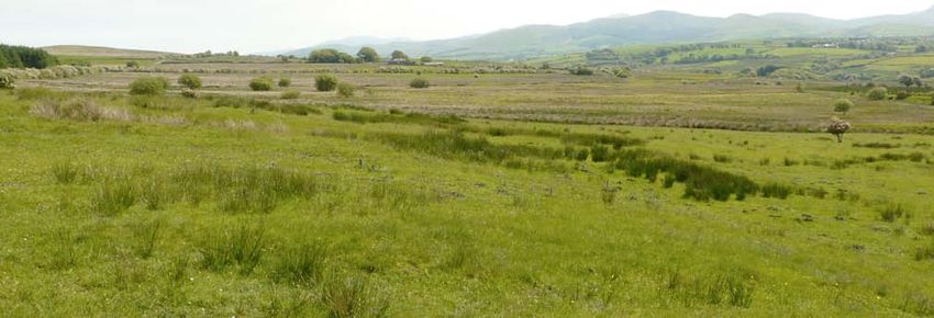
National Character                   7. West Cumbria Coastal Plain
      Area profile:                                                                                                                                       Supporting documents

                                                                                                                                              Key facts      Landscape           Analysis
                                     Introduction & Summary            Description                        Opportunities
                                                                                                                                              and data       change

   Statements of Environmental Opportunities:

   ■■ SEO 1: Conserve and enhance the unique open coast and estuarine                             ■■ SEO 3: Improve and enhance sustainable recreation, enabling people to
      landscapes with their distinct geology, improving and connecting habitats                      experience the peace and beauty of the area and learn more about its
      and their species, and enabling natural coastal processes to occur to                          biological, geological and heritage assets and natural processes, while
      enhance and improve the coast’s ability to adapt to and mitigate the                           managing visitor pressure to conserve the highly valued tranquillity and
      impact of climate change.                                                                      protect the sensitive semi-natural habitats and species found there.

   ■■ SEO 2: Manage and enhance the farmed environment to secure viable                           ■■ SEO 4: Manage industrial and former industrial sites to accommodate both
      and sustainable farming, improving water quality of the rivers and                             their economic and environmental potential by managing new energy
      coast, reducing soil erosion, strengthening historic landscape character,                      industries, growth areas and their associated infrastructure to provide
      conserving heritage features and archaeology, supporting species                               social and environmental gain while minimising pollution and disturbance
      populations that are dependent on this area, and improving habitat                             and to improve ecological connectivity in the landscape, particularly in
      connectivity.                                                                                  urban-fringe areas.

      The importance of the honeycomb worm reefs along the coast has been recognised in the first tranche of Marine Conservation Zone designations.

                                                                                                                                                                    4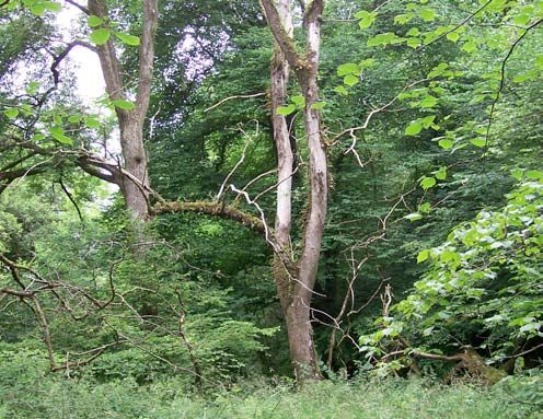
National Character               7. West Cumbria Coastal Plain
      Area profile:                                                                                                                              Supporting documents

                                                                                                                                 Key facts           Landscape            Analysis
                                 Introduction & Summary        Description                   Opportunities
                                                                                                                                 and data            change

   Description                                                                        the coast being interrupted by the estuaries. The southern parts of the NCA
                                                                                      share sediments with the Morecambe Bay Limestones NCA in Morecambe
   Physical and functional links to other National                                    Bay itself. The estuarine landscapes of the Esk and Duddon lead to a series
   Character Areas                                                                    of islands – Walney, Foulney and Piel – formed by material brought down
                                                                                      predominantly from the Cumbria High Fells during past ice ages.
   The West Cumbria Coastal Plain National Character Area (NCA) forms an
   undulating band of varying width between the mountains of the Lake District        Coastal trade and Roman routes have been adopted today as A roads linking
   to the east and the Irish Sea to the west. In the south of the area, the narrow    the area with the Solway Basin NCA. Further routes connect through the
   coastal plain around the Duddon Estuary is abutted by the South Cumbria            valley of the River Derwent to Keswick in the Lake District High Fells Special
   Low Fells NCA, and Morecambe Bay Limestones NCA fringes the coast around           Area of Conservation (SAC) and beyond. The southernmost parts of the NCA
   Barrow-in-Furness. To the north, the coastal plain widens into the Solway Basin    were formerly reached over the sands of Morecambe Bay until Victorian
   NCA. The eastern boundary with the Cumbria High Fells NCA is marked by the         trade drove improvements in road and rail access around the southern part
   change from enclosed pastoral lowlands to open fellside. Throughout the area,      of Cumbria through the Morecambe Bay Limestones NCA.
   extensive views inland are set against the High Fells, while along the coast it
   is the influence of the Irish Sea that dominates long-distance views, and on a
   clear day the Isle of Man and the peninsulas of Galloway can be seen.

   The NCA is crossed by a series of rivers including the Derwent, Ehen, Irt, Mite,
   Esk and Duddon, which descend from the Cumbria High Fells NCA and South
   Cumbria Low Fells NCA to discharge into the Irish Sea.

   North of St Bees the coastline consists of a mix of intertidal flats, beaches
   and coastal defence works. Coastal processes move material northwards
   with erosion feeding the beaches of the Solway Coast Area of Outstanding
   Natural Beauty (AONB). The central section of the coastline is dominated
   by the red sandstone cliffs of St Bees Head with shingle beaches, intertidal
   sands and mudflats, salt marsh and sand dunes. South of St Bees the pattern           Juxtapositions of important wildlife sites with past and present industry and their
                                                                                         associated communities are a common feature throughout the NCA.
   is more complicated, with a general southwards movement of material along

                                                                                                                                                              5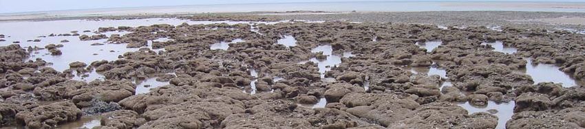
National Character              7. West Cumbria Coastal Plain
      Area profile:                                                                                                                    Supporting documents

                                                                                                                          Key facts         Landscape         Analysis
                                Introduction & Summary       Description                   Opportunities
                                                                                                                          and data          change

   Key characteristics

     ■■ The NCA consists of an undulating coastal landscape of varying width        ■■ There is limited tree cover, with most woodland to be found on steeper
        with open views to the Cumbria High Fells NCA and across the Irish Sea         slopes and along river corridors. There are some plantation woodlands
        to Galloway and the Isle of Man.                                               and shelterbelts associated with the upland margins of the area and
     ■■ The area has a diverse, open coastline ranging from depositional sand,         former open cast mining sites.
        shingle and pebble beaches and sand dunes, through low soft cliffs          ■■ There is a dispersed rural settlement pattern of hamlets and isolated
        of glacial or industrial origin, to high sandstone cliffs with a rich and      farmsteads with some villages.
        varied flora and fauna, including dune grasslands, seabird colonies and     ■■ Distinctive building materials are a combination of locally quarried red
        the natterjack toad.                                                           sandstone, red brick and render augmented by coastal pebbles along
     ■■ There are lowland river valleys with limited ancient semi-natural              the southern coast.
        woodland, and expansive estuarine landscapes with lowland raised            ■■ Larger urban settlements and coastal towns are closely linked with the
        mires, salt marshes, mudflats and intertidal habitats with large numbers       growth and location of the area’s strong industrial history of coal and
        of wintering waders and wildfowl.                                              iron ore mining, processing ore, smelting and ship-building.
     ■■ Important areas of brownfield biodiversity, often in urban-fringe           ■■ Extensive urban-fringe influence is linked to highly visible industrial
        locations, are characterised by rare plants, reptiles and invertebrates        past and present, including quarrying, open cast mining, restoration
        including the small blue butterfly.                                            and reclamation initiatives, manufacturing and processing plants and
     ■■ The area includes open pastoral farmland with occasional woodlands,            the nuclear energy industry.
        basin and valley fens, remnant semi-natural grasslands/meadows              ■■ A rich history is evident in the pattern of land use and heritage features
        associated with streamsides, low-lying land, and localised pockets of          dating from the Neolithic period onwards, including earthworks,
        arable land supporting species such as curlew and wintering hen harrier.       forts and castles and all the Roman coastal forts that form part of the
     ■■ There are areas of ancient enclosure with medium to large rectilinear          Hadrian’s Wall World Heritage Site.
        fields and few hedgerow trees. They are bounded by hedges (often
        gappy and augmented by wire fences), stonewalls on higher ground,
        and stone-faced earthbanks locally known as ‘kests’ along the coast.

                                                                                                                                                   6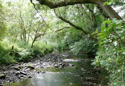
National Character 7. West Cumbria Coastal Plain
Area profile: Supporting documents
Key facts Landscape Analysis
Introduction & Summary Description Opportunities
and data change
West Cumbria Coastal Plain today strongholds for species such as the Isle of Man cabbage, the oyster plant and
the Walney geranium, an endemic form of bloody cranesbill.
The West Cumbria Coastal Plain NCA is one of the most varied NCAs in
England. It combines dramatic coastal landscapes and wind-swept farmland, Inland, from the coast, the agriculture changes from mixed arable and
punctuated by meandering river valleys flowing across the plain from east to improved pasture near the coast, to predominantly livestock grazing inland.
west to the Irish Sea, with industrial towns all set against the backdrop of the Fields are irregular and anciently enclosed with some medium to large-scale
Lake District mountains. All along the coast and elevated areas inland, there rectangular fields of the late 18th to 19th centuries, especially along the
are extensive views across the Irish Sea and towards the hills of southern coast. They are bounded mainly by hedgerows on lower-lying ground, with
Scotland and the Isle of Man. stone walls on higher ground, and traditionally built, stone-faced ‘kest’ banks
along the coastal margin. In exposed areas, hedgerow trees are stunted and
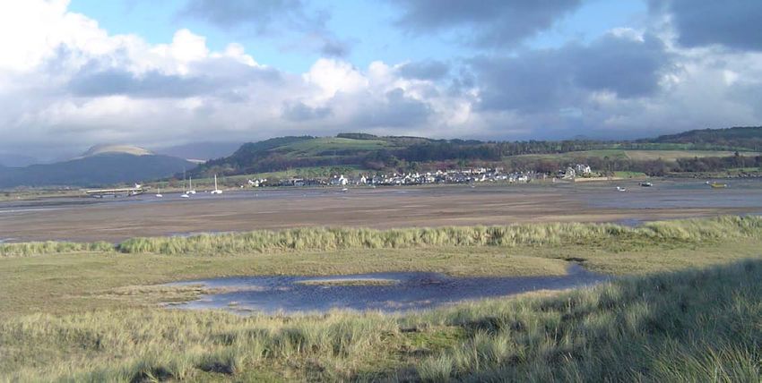
In the south there are extensive shingle and sand systems around Furness sheared by prevailing salt-laden westerly winds. Broadleaved woodland,
and the Duddon Estuary, and the open barrier islands of Walney and Foulney including remnant ancient woodlands, is found along the river corridors.
where the open expanses of Morecambe Bay grade first into beaches, Small mixed and coniferous plantations, and shelterbelts, are scattered
dunes and marshes and then low-lying farmland. Between the mouth of the inland and on the lower fringes of the Lake District fells. They are also a
Duddon Estuary and St Bees is a coast of soft sediments and slumping cliffs, feature of reclamation schemes from past coal and ore mining, open cast and
broken by the estuary system at Ravenglass, with its associated dunes. degraded industrial land, especially around Workington.
At St Bees Head, the soft cliffs give way abruptly to 100-metre-high red
sandstone cliffs, capped by a narrow band of species-rich grasslands. North
of St Bees the coast consists of a mix of intertidal flats, soft cliffs of natural or
industrial origin and narrow beaches. This area is also dominated by the broad
flood plain of the River Derwent and its tributaries as it flows westwards from
Bassenthwaite Lake through Cockermouth to the sea at Workington.
The coast from Walney to St Bees has a number of designated sites, nationally
and internationally important, for their coastal sand dune, vegetated shingle
and salt marsh communities as well as breeding seabirds, wintering waders The barrier island landscape surrounding Barrow-in-Furness is expansive and
constantly changing with the light, tide and weather.
and wildfowl, the natterjack toad and specialist flora. It includes national
7
National Character                7. West Cumbria Coastal Plain
      Area profile:                                                                                                                                Supporting documents

                                                                                                                                    Key facts          Landscape          Analysis
                                  Introduction & Summary          Description                    Opportunities
                                                                                                                                    and data           change

   Inland the area supports a number of nationally and internationally important          of ancient woodland that are a feature of the more sheltered valleys. Popular
   lowland wetlands. These include lowland raised bogs, with their unique                 features for visitors and locals seeking quiet recreational experiences include
   vegetation of peat-forming sphagnum mosses and dwarf shrubs, the rivers                the coastline, coastal ports, historical assets such as Hadrian’s Wall /forts, the
   Ehen and Derwent with populations of salmonid fish, lamprey, freshwater pearl          Lake District National Park and the St Bees Heritage Coast. The area also acts
   mussels and water crowfoot beds, and an assortment of basin and valley fens.           as gatekeeper to the isolated, ‘dead-end’, west-facing valleys of the western
                                                                                          Lake District. National Trails include the Hadrian’s Wall Cycleway (part of the
   The main access routes into the area are from the southern and northern                National Cycle Network) from Ravenglass northwards, the Coast to Coast Walk
   extremities of the NCA. By road, northern access routes through the Derwent            heading east from St Bees Head, and the England Coast Path National Trail.
   Valley and along the margins of the Solway Basin date back to Roman times. In
   contrast, the southern route into Furness and Barrow is more recent, being 19th
   century in origin, with earlier routes being mainly across the sands of Morecambe
   Bay. The railway is also 19th century in origin, running along a single route around
   the coastal periphery of the NCA and linking all the main settlements.

   Throughout the area there is a strong juxtaposition between industrial, or
   post-industrial, and rural landscapes: former mining towns sit in restored
   farmland; industrial towns, such as Barrow, and complexes, such as Sellafield,
   suddenly give way to undeveloped coasts; modern wind farms, both onshore
   and offshore, are set against mountains or the open sea.

   The area retains a diverse economy. Energy and chemical industries, ship-building,
   agriculture, aquaculture, shellfisheries and tourism are all important employers
   whose roots lie in the area’s natural assets. The energy industry is particularly
   apparent in the landscape with nuclear and biomass power stations and many,
   onshore and offshore, wind farms being highly visible from many areas.

   Remaining areas of tranquillity are associated with the undeveloped stretches             The Sellafield complex is a dominant feature of the landscape and seascape
                                                                                             between St. Bees and the Duddon.
   of coastline and the farmland abutting the higher fells, as well as the patches

                                                                                                                                                               8
National Character                7. West Cumbria Coastal Plain
      Area profile:                                                                                                                          Supporting documents

                                                                                                                               Key facts         Landscape          Analysis
                                  Introduction & Summary         Description                    Opportunities
                                                                                                                               and data          change

   The landscape through time                                                            onwards includes bronze-age clearances, stone circles and one of the most
                                                                                         important settlement sites in northern England, at Ehenside Tarn, where
   The landscape of the West Cumbria Coastal Plain NCA is geologically complex.          there is evidence of some of the earliest arable cultivation in the country. The
   Predominantly sedimentary, and dominated by sandstone, there is a significant         Romans formalised trade and established ports at Ravenglass, Workington
   presence of metamorphic and igneous rocks as a result of volcanic activity in         and Maryport at the edge of the Empire for trade and to support the frontier
   central Cumbria. The geology can be split into two broad areas. North of St Bees      defences of Hadrian’s Wall and its numerous associated forts, now afforded
   Head, Carboniferous-age Coal Measures and Limestones outcrop, the latter with         World Heritage Site status.
   pockets of iron ore. These rocks are overlain in the Whitehaven area by small
   outliers of Permo-Triassic red sandstones (‘New Red Sandstone’). South of St Bees     The area of Copeland to the south of Whitehaven was important in Norman
   Head, the area is dominated by Permo-Triassic red sandstones, with some of the        times as the seat of the barony which was located at Egremont. Between the
   overlying mudstones present in the Barrow-in-Furness area. In the east of the area,   12th and mid-16th centuries the area was dominated by monasteries, with
   between Ravenglass and Millom, older Ordovician-age mudstones, sandstones             Calder Abbey, Furness Abbey and St Bees Priory having major urban and
   and igneous rocks outcrop as a result of volcanic activity in central Cumbria.        coastal landholdings. The monks had considerable regional influence in the
                                                                                         establishment of improved agricultural systems and in the management of
   This landform was moulded through the ice ages by glacial processes, being            the woodlands for the production of fuel and timber for building purposes.
   covered by ice originating both from southern Scotland and from the Lake              A number of castles and other fortified buildings evidence the need for
   District. This affected the whole area, and the eventual retreat left a widespread    defence and the development of estate centres during the medieval period.
   mantle of till with, in places, sand and gravel and, importantly, coastal drumlin
   features that evolved into the barrier island of Walney and its adjacent islands.     The discovery of coal and iron ore deposits stimulated early industrial
   Walney itself is the largest barrier island in England and is unusual in its macro-   development with mines and processing industries, and adjacent mining
   tidal location. In the post-glacial period, coastal processes on the open coast       communities were established around Whitehaven, Workington and
   have re-worked coastal sediments, redistributing glacial material along the           Maryport. Trade grew in importance and led to the development of the
   coast and forming extensive sand dune systems and areas of slumped soft               ports acting as the gateway for the export of the area’s natural resources, in
   cliffs. In the more sheltered environments of the estuaries, salt marshes have        particular mined materials such as coal, alabaster, sandstone and iron ore, as
   evolved and, particularly around the Duddon Estuary, peat formation in raised         well as slate from the adjoining fells.
   bogs has adapted the underlying landform.
                                                                                         Growth in the coastal ports was dramatic with the development of a number
   Extensive evidence for land use and settlement from the Neolithic period              of planned ‘civic’ central areas and buildings usually constructed in local red

                                                                                                                                                         9
National Character               7. West Cumbria Coastal Plain
      Area profile:                                                                                                                             Supporting documents

                                                                                                                                 Key facts           Landscape           Analysis
                                 Introduction & Summary         Description                   Opportunities
                                                                                                                                 and data            change

   sandstone. Whitehaven was planned on a formal grid pattern by Lord Lonsdale         a prominent feature, although agriculture remains the predominant land use.
   in the 1640s. Maryport was developed by Humphrey Senhouse in 1749 and               Isolated farmsteads are scattered over the upland fringes where sheep/cattle
   the town’s prosperity was based on the local coal and iron ore mines and the        grazing predominates. Agriculture intensified through the 20th century, with
   extensive port facilities. Barrow-in-Furness, originally a small fishing village,   arable cropping increasing on the coast. In some areas of marginal land, more
   was influenced by the iron and steel industry and transformed into a major          extensive low-intensity pastoral systems have survived for livestock rearing/
   ship-building centre with extensive dockyards during the Victorian period that      grazing. As well as the upland fringes, this includes the sand dune systems
   were strategically significant during the Second World War.                         flanking the Ravenglass and Duddon estuaries, and areas on the urban fringes
                                                                                       of larger towns such as Barrow-in-Furness, and on Walney Island.
   The development of the railway network from the 1850s led to the prosperous
   development of further mining communities based on the extraction of iron           The decline of industry and changes in agriculture have led the area’s
   ore, coal, alabaster, gypsum and sandstone. Villages with rows of terrace           economy to turn more to the tourist industry centred around the quiet
   houses of red brick were built adjacent to the mines, but subsequent industrial     coastline, long-distance trails – such as Wainwright’s Coast to Coast walk –
   decline – as a result of the introduction of new technologies, depletion            and the re-use of former mineral railways as cycle ways. Recreational facilities
   of mineral resources and recession – has meant that many towns have                 are paramount to the Lake District National Park ‘brand’ and the role of the
   been through boom and bust periods of rapid growth then decline, social             area as gatekeeper to the western Lake District fells and valleys.
   deprivation and depopulation as mines have closed or demand for industrial
   products has dwindled. This has led in many places to a juxtaposition of rural
   landscapes with post-industrial urban landscapes, including spoil heaps,
   waste tips, mineral railways, semi-derelict land and abandoned houses. The
   1950s saw the construction of Calder Hall to generate nuclear power and
   has become a major source of employment. Subsequent decades have seen
   the establishment of nuclear waste reprocessing plants and underground
   storage at Windscale, now Sellafield. These industrial complexes dominate the
   coastline between St Bees and Ravenglass, and views from the surrounding
   uplands. The end of the 20th century saw re-working of mineral spoil heaps,
   open cast coal mining and subsequent land restoration/reclamation schemes.

   Away from the coast, the settlement pattern is dispersed, with farmsteads              Many former industrial sites are now recognised as being nationally important for
                                                                                          both their geology or biology, or both as here at Clints Quarry.
   and hamlets interspersed with some villages: housing for industrial workers is

                                                                                                                                                            10
National Character 7. West Cumbria Coastal Plain
Area profile: Supporting documents
Key facts Landscape Analysis
Introduction & Summary Description Opportunities
and data change
Ecosystem services Provisioning services (food, fibre and water supply)
■ Food provision: Agricultural land in the NCA is mainly managed as pastoral
The West Cumbria Coastal Plain NCA provides a wide range of benefits to systems for livestock grazing, mainly sheep and beef. Arable systems,
society. Each is derived from the attributes and processes (both natural and mainly cereals, are locally dominant on the free-draining sandstone
cultural features) within the area. These benefits are known collectively geology around St Bees. Unimproved grasslands, particularly in the coastal
as ‘ecosystem services’. The predominant services are summarised below. zone and on higher fellsides in the east, are sometimes used for extensive
Further information on ecosystem services provided in the West Cumbria grazing by rare breeds, particularly cattle. Morecambe Bay and the Duddon
Coastal Plain NCA is contained in the ‘Analysis’ section of this document. Estuary support traditional coastal fisheries for cockles and mussels.
■ Biomass energy: The existing woodland cover (5.9 per cent) offers
some potential for the provision of biomass through bringing existing
unmanaged woodland under management or as a by-product of
commercial timber production. The recent opening of a biomass power
station in the northern part of the NCA at Workington has increased the
potential market for wood fuel from existing woodland, new woodland
and planted short rotation coppice. Although much of the material to
fuel the power station is imported from abroad, there is likely to be an
ongoing increase in woodland cover in this area.
■ Water availability: The NCA’s main rivers – the Derwent, Ehen, Calder, Irt,
Mite, Esk and Duddon – all have their headwaters in the Cumbria High Fells
NCA where many of these rivers also drain major lakes such as Bassenthwaite
Lake, Crummock Water, Ennerdale Water and Wastwater. The West
Cumbrian coast and the Furness area in the south of the NCA are home to
significant amounts of industry, including nuclear power generation and
manufacturing, and these are some of the key water abstractors.
The intertidal expanses of Morecambe Bay have long been an important resource for
fishermen.
11National Character 7. West Cumbria Coastal Plain
Area profile: Supporting documents
Key facts Landscape Analysis
Introduction & Summary Description Opportunities
and data change
Regulating services (water purification, air quality maintenance and ■ Regulating coastal flooding and erosion: The coastline comprises of
climate regulation) extensive areas of coastal and estuarine habitat, including coastal sand
■ Climate regulation: Carbon is stored in those of the NCA’s habitats where dunes and salt marshes that act as the primary defence against coastal
soils have remained undisturbed for very long periods, including its flooding and erosion. Also by allowing natural coastal processes to take
coastal and flood plain grazing marsh, lowland heath, reedbeds and fens place unimpeded can provide a natural defence to increased sea level
and, in particular, the peat soils of the lowland raised mires at the head rise and storminess experienced along this coastline, thus reducing
of the Duddon Estuary. The latter act as both carbon stores and active the risk of flooding to built-up areas. In different areas, estuarine tidal
sequesters of carbon when in good condition. Carbon storage is also flooding or direct coastal flooding is of greatest threat. Along a significant
provided by the 2,931 ha of woodland within the NCA (6 per cent of its portion of the coast, the railway line provides the primary sea defence, an
area) and its underlying humus-rich soils. important piece of transport infrastructure at risk from coastline change.
The railway line affects the sediment supply to other areas around the
■ Regulating soil erosion: Parts of the River Derwent catchment, the immediate coast by interrupting and limiting the sediment available to build/sustain
catchment of the Duddon Estuary and the River Ehen catchments are priority coastal habitat and hence provides a natural defence to climate change.
catchments under the Catchment Sensitive Farming Programme in this NCA.
Soil erosion and diffuse pollution into watercourses are identified as key Cultural services (inspiration, education and wellbeing)
issues in all areas. Around the St Bees peninsula, the dominance of arable ■ Sense of place/inspiration: Sense of place is provided by the varied, open
systems on sloping ground puts soils at risk of erosion from rainfall. The salt coastline of mudflats, shingle and pebble beaches, sand dunes, high red
marsh soils around the estuaries are subject to coastal erosion. sandstone cliffs and soft cliffs, each with its own character derived from local
variations in geology. Some 12 per cent of the coastal plain is part of the Lake
■ Regulating water flow: The catchments in the South West Lakes flood District National Park, mainly in the south. The agricultural hinterland is open
management area (for example, the rivers Duddon, Esk, Irt and Ehen) and wind-swept, with medium to large fields grazed by livestock. There is a
are relatively small, rising on the high, rugged and steep-sided, western strong industrial character permeating throughout, clustered around the main
fells of the Lake District, before flowing in a westerly or south-westerly towns with former coal mining and mineral extraction sites and current open
direction via lakes such as Wastwater and Ennerdale Water across the cast, industrial and energy sites contributing to the rich cultural heritage and
narrow coastal plain to discharge into the Irish Sea. The River Derwent sense of place. The views out from the NCA are expansive and embrace the
catchment starts in the Cumbria High Fells NCA and crosses the northern Lake District fells, Irish Sea, Isle of Man and south Scotland. In recent years
coastal plain via Bassenthwaite Lake and the town of Cockermouth these views have been modified by the increase in coastal and offshore wind
before joining the sea at Workington. developments and increasing nuclear energy processing plants.
12National Character 7. West Cumbria Coastal Plain
Area profile: Supporting documents
Key facts Landscape Analysis
Introduction & Summary Description Opportunities
and data change
■ Sense of history: The chain of Roman coastal forts, stretching north from and associated forts, the Lake District National Park (12 per cent of which
Ravenglass, form part of the Hadrian’s Wall World Heritage Site. There is a is in the NCA) and the St Bees Heritage Coast are also popular features for
strong, industrial, built heritage associated with the stone cottages and brick visitors and locals seeking quiet recreational experiences.
terraced rows of the coalfield settlements, which contrast with the influential
parkland estates such as Muncaster Castle, Workington Hall and Egremont ■ Biodiversity: The NCA supports a wide range of nationally and internationally
Hall. There is also a wealth of archaeological features as well as the legacies important habitats and species – the latter including seabird colonies,
of mining, steel-making and ship-building industries. This is supported by a honeycomb worm reefs, wintering waders and wildfowl, freshwater
local vernacular architecture and use of red St Bees sandstone as a building pearl mussel and the natterjack toad – and contains five Special Areas of
material. In the south, a series of First World War and Second World War anti- Conservation, two Special Protection Areas and two Ramsar sites, with
invasion defences such as pillboxes and observation posts built to defend over 3,300 ha nationally designated as Sites of Special Scientific Interest.
Barrow-in-Furness and vital shipping lanes remain. Remnants of an enclosed In addition, the area has five Local Nature Reserves and 163 Local Wildlife
landscape of small to medium-scale pastures dating from the 14th to 17th Sites, which provide further habitats for wildlife and also opportunities for
centuries exist around Walney Island in the south. communities to engage with and enjoy nature close to where they live.
■ Tranquillity: Although industry has a significant influence on the area, ■ Geodiversity: The area’s diverse geology supports a number of nationally
tranquillity is still an important feature, with 43 per cent of the NCA important sites for sedimentary (including both sandstone and limestone
classified as ‘undisturbed’. The majority of ‘undisturbed’ land occurs along sites), igneous and glacial geologies. In the intertidal zone, the cobble
the undeveloped coastline to the south of Seascale and the farmland and skears that are the remains of glacial drumlins are an important feature
sheltered river valleys inland of Workington and Whitehaven. as they form the substrate on which biogenic reefs of honeycomb
worm and mussels establish. Walney Island is exceptional as a barrier
■ Recreation: Recreation is supported by 595 km of rights of way (at a island both in its origins and scale. Peat-forming bogs and dynamic
density of 1.21 km per km2), plus around 1,350 ha of open access land intertidal environments are both examples of dynamic geomorphological
covering 2.7 per cent of the NCA. Statutory access is supplemented by processes, with the former also maintaining an important palaeo-
a series of nature reserves along the coast providing various levels of environmental record. Most peat bogs have been damaged but many
permissive access and common land. Hadrian’s Cycleway (part of the sand dunes and salt marshes are well managed.
National Cycle Network), the Coast to Coast path and the England Coast
Path National Trail are all important assets. The coastline, distinctive
coastal settlements, historic assets, Hadrian’s Wall World Heritage Site
13National Character 7. West Cumbria Coastal Plain
Area profile: Supporting documents
Key facts Landscape Analysis
Introduction & Summary Description Opportunities
and data change
Statements of Environmental Opportunity
SEO 1: Conserve and enhance the unique open coast and estuarine landscapes with their distinct geology, improving and connecting habitats and their
species, and enabling natural coastal processes to occur to enhance and improve the coast’s ability to adapt to and mitigate the impact of climate change.
For example, by:
■■Implementing actions identified in the Shoreline Management Plan, to ■■Restoring the lowland raised bogs of the Duddon Estuary as part of a
secure a sustainable management regime for the coast. series of sites that spans the boundary with the South Cumbria Low Fells
■■Developing a series of coastal nature reserves that, through best National Character Area (NCA).
practice visitor management, provide a high-quality visitor experience ■■Supporting programmes that bring together the different elements
without compromising environmental assets, and promote better of the heritage of the coastal environment, including its rich social,
appreciation and respectful use of the wider coastal environment. cultural, historical and natural histories, and presenting them as a single
■■Ensuring that habitat quality is sufficiently high to support specialist package to access the economic potential of the coastal environment.
species such as the natterjack toad, Isle of Man cabbage, northern dune ■■Securing shellfisheries, and aquaculture, management that supports
tiger beetle, breeding colonial seabirds including auks, gulls, terns and internationally important coastal sites and their bird populations and is
eider, and wintering waders; and including species that have been lost economically sustainable.
in the past, such as roseate tern and oyster plant. ■■Producing a plan of key actions for the protection and enhancement of
■■Raising awareness of coastal dynamics, including coastal change, the St Bees Heritage Coast.
and habitats such as coastal sand dunes, vegetated shingle, and salt ■■Providing a high-quality England Coast Path National Trail that informs
marsh in protecting the coast and ensuring that coastal development visitors to the sensitivities of the coastal environment and promotes
is sustainable. Also the interdependence between coastal erosion and informed enjoyment of the coast and adjacent areas.
accretion in supporting naturally functioning coastal systems that also ■■Restoring stone-faced earthbank ‘kests’ as field boundaries in the
provide coastal protection. coastal zone.
■■Encouraging and promoting local volunteering opportunities to further ■■Seeking opportunities to reduce man-made marine litter washed up on
public engagement with the natural environment. beaches.
■■Developing physical and educational links between the urban centres ■■Raising awareness of the distinctive geological, particularly glacial, origins
and the adjacent high-quality coastal environment. of the coastal landscape and the role of active processes in maintaining it.
14National Character 7. West Cumbria Coastal Plain
Area profile: Supporting documents
Key facts Landscape Analysis
Introduction & Summary Description Opportunities
and data change
SEO 2: Manage and enhance the farmed environment to secure viable and sustainable farming, improving water quality of the rivers and coast,
reducing soil erosion, strengthening historic landscape character, conserving heritage features and archaeology, supporting species populations
that are dependent on this area, and improving habitat connectivity.
For example, by:
■■Supporting the delivery of key actions in the Lake District National Park ■■Restoring drystone walls where these have fallen into decay and
Management Plan aimed at protecting and enhancing National Park maintaining the link between walls and local geology such as St Bees
landscape and its surrounds. sandstone in the northern part of the NCA and field stone on the
■■Protecting wetland communities, in particular valley and basin fens, upland fringes.
from diffuse pollution and securing appropriate land management in ■■Exploring opportunities for better management of below-ground
their catchments. archaeology on arable land, such as establishment of permanent
■■Promoting farming practices that reduce the loss of soil and nutrients grassland, shallow cultivation or minimum tillage agriculture, and
from farmland into watercourses causing diffuse pollution, particularly encouraging uptake of agri-environment schemes to fund such work.
along the River Marron tributary of the River Derwent. ■■Maintaining and restoring the extensive areas of species-rich, rush
■■Securing integrated water supply sources for the area currently pasture grasslands and transitional heathlands in the West Cumbria
dependent on abstraction form the River Ehen catchment. coalfields with their series of specialist species, including breeding
■■Restoring and enhancing the series of biological and geological Sites of curlew and wintering hen harrier.
Special Scientific Interest (SSSI), through both targeted measures and ■■Strengthening traditional field patterns by managing, restoring and
wider promotion of the social, cultural, historical and economic value of replanting hedgerows where they are the traditional boundary type.
these sites. ■■Increasing woodland cover in appropriate areas to buffer, connect and
■■Restoring and establishing woodlands along watercourses to improve extend woodland habitats and increase productive woodland where it
water quality, control erosion and flooding, and improve habitat will not damage semi-natural open habitats.
connectivity and resilience. ■■Delivering more natural river processes through re-naturalisation
■■Securing management of arable crops that provides for the needs of of modified stretches of the River Derwent as identified in the River
farmland wildlife such as lapwing, skylark, yellow wagtail and grey partridge, Restoration Strategy.
and including lost species such as corn bunting, especially around St Bees.
Continued on next page
15National Character 7. West Cumbria Coastal Plain
Area profile: Supporting documents
Key facts Landscape Analysis
Introduction & Summary Description Opportunities
and data change
Continued from previous page
■■Managing river corridors to provide high-quality habitat for specialist
aquatic species such as freshwater pearl mussel, salmon and lamprey.
■■Protecting and restoring ancient woodlands, especially Plantations
on Ancient Woodland Sites, and increasing management of existing
under-managed woodlands to provide multiple benefits.
■■Managing invasive non-native species such as Himalayan balsam and
Japanese knotweed so they do not damage the area’s biodiversity,
and monitoring the impacts of new tree pests and diseases.
■■Maintaining and restoring traditional farm buildings, through
continued agricultural use where possible, and ensuring that through
re-use their heritage interest is retained.
■■Maintaining the diversity of geology and traditional buildings that
contributes to the NCA by using, promoting and encouraging locally
sourced materials and skills for walling and building repair and
construction.
The extensive unimproved pastures of the NCA are important both for biodiversity
and as a part of the farming system.
16National Character 7. West Cumbria Coastal Plain
Area profile: Supporting documents
Key facts Landscape Analysis
Introduction & Summary Description Opportunities
and data change
SEO 3: Improve and enhance sustainable recreation, enabling people to experience the peace and beauty of the area and learn more about its
biological, geological and heritage assets and natural processes, while managing visitor pressure to conserve the highly valued tranquillity and
protect the sensitive semi-natural habitats and species found there.
For example, by:
■■Increasing the awareness of nature reserves in urban and industrial ■■Supporting programmes that bring together the different elements
landscapes, such as Siddick Ponds, and develop their role as sites that of the heritage of the coastal environment, including its rich social,
deliver education, promote health and support the local economy cultural, historical and natural histories, and presenting them as a single
alongside their nature conservation value. package to access the economic potential of the coastal environment.
■■Enhancing the recreational potential of assets of the Lake District ■■Developing the role played by the coastal railway as an access route
National Park both in the NCA and in the areas accessed through it for to the coast and as an asset that can be linked to the area’s recreation
visitors and residents alike, improving economic and social appreciation offers such as Hadrian’s Cycleway (part of the National Cycle Network)
of the area. and the Coast to Coast path.
■■Making use of the new England Coast Path National Trail to articulate ■■Protecting the expansive views across the Irish Sea to the Isle of Man
messages about the environmental sensitivity of the coast and the and south Scotland and across Morecambe Bay.
role played by coastal processes and habitats in providing coastal ■■Documenting and where appropriate protecting archaeology at risk
protection. from coastal processes or loss to vegetation.
■■Protecting where appropriate, documenting and raising awareness of ■■Seeking opportunities to restore former railway lines as access routes.
the area’s rich archaeological heritage from Neolithic times to the First ■■Encouraging better management of dogs to reduce disturbance of
World War and Second World War. sensitive species and reduce fouling in areas important for wildlife and
■■Conserving archaeological and other historic features in the landscape recreation.
with heritage interest, raising awareness of how land use and other ■■Supporting and assisting the World Heritage Committee in giving
historic processes have shaped the landscape while also recognising the effect to the operative management plan and delivering agreed-upon
potential for undiscovered remains. priorities in support of the Statement of Outstanding Universal Value, as
is required of the government by treaty.
17National Character 7. West Cumbria Coastal Plain
Area profile: Supporting documents
Key facts Landscape Analysis
Introduction & Summary Description Opportunities
and data change
SEO 4: Manage industrial and former industrial sites to accommodate both their economic and environmental potential by managing new energy
industries, growth areas and their associated infrastructure to provide social and environmental gain while minimising pollution and disturbance
and to improve ecological connectivity in the landscape, particularly in urban-fringe areas.
For example, by:
■■Increasing the value of brownfield sites as providers of both urban ■■Seeking opportunities to restore ex-quarrying and other post-industrial
greenspace and biodiversity. sites as species-rich, semi-natural habitat that supports amenity use
■■Making links between urban greenspace and rural greenspace for the while retaining an identity that embraces their historical heritage.
benefit of both wildlife and people, including brownfield areas. ■■Seeking opportunities to establish green infrastructure that supports
■■Using understanding of the area’s traditional and historic architecture, economic, social and environmental outcomes and promoting the
and its distinct patterns of settlement, to inform appropriate wider green infrastructure benefits of development that accommodate
conservation and use of historic buildings, and to plan for and inspire biodiversity, with a particular focus on species characteristic of the area.
any environmentally beneficial new development that makes a positive
contribution to local character.
■■Increasing awareness of the value of brownfield sites in the coastal zone
for biodiversity, including local specialities such as small blue butterfly,
pyramidal orchids and purple broomrape, and seeking appropriate
management or mitigation where sites are subject to change.
■■Seeking opportunities to achieve better-quality habitat for wildlife as a
component of future industrial development through good design and
planning.
■■Enabling the natural environment to act as an asset to attract investment
and skilled professionals to the area to drive economic growth based on
a high-quality natural environment.
■■Developing programmes around Whitehaven and St Bees that make use
of the high-quality natural environment and mining heritage as an asset A number of former mine buildings have been adapted into museums securing
links with the area’s mining past.
in urban regeneration programmes.
18National Character 7. West Cumbria Coastal Plain
Area profile: Supporting documents
Key facts Landscape Analysis
Introduction & Summary Description Opportunities
and data change
Supporting document 1: Key facts and data West Cumbria Coastal Plain National
Character Area (NCA): 49,293 ha
Please note: (i) Designated areas may overlap (ii) all figures are cut to Mean High Water Line,
1. Landscape and nature conservation designations designations that span coastal areas/views below this line will not be included.
The NCA includes part of one designated landscape, the Lake District
National Park, of which 6,117 ha is in the NCA (covering 12 per cent of the There are 163 local sites in West Cumbria Coastal Plain covering 1,681 ha,
NCA). The NCA also includes the entirety of the St Bees Head Heritage Coast which is 3 per cent of the NCA.
which covers 573 ha (1 per cent of the NCA). Source: Natural England (2011)
Management plans for the protected landscape can be found at: ■ Details of individual Sites of Special Scientific Interest can be searched at:
■ www.lakedistrict.gov.uk http://www.sssi.naturalengland.org.uk/Special/sssi/search.cfm
Source: Natural England (2011) ■ Details of Local Nature Reserves (LNR) can be searched at:
http://www.lnr.naturalengland.org.uk/Special/lnr/lnr_search.asp
1.1 Designated nature conservation sites ■ Maps showing locations of Statutory sites can be found at:
The NCA includes the following statutory nature conservation designations: http://magic.defra.gov.uk/website/magic/ – select ‘Rural Designations Statutory’
Tier Designation Designated site(s) Area (ha) % of NCA
International Ramsar Duddon Estuary, 1,958 4 1.1.1 Condition of designated sites
Morecambe Bay
Condition category Area (ha) % of SSSI land in category condition
European Special Protection Duddon Estuary SPA, 1,958 4
Area (SPA) Morecambe Bay SPA Unfavourable declining 148 4
Special Area of Morecambe Bay SAC, Drigg 2,916 6 Favourable 2,088 63
Conservation (SAC) Coast SAC, Duddon Mosses Unfavourable no change 403 12
SAC, River Derwent and
Unfavourable recovering 632 19
Bassenthwaite Lake SAC, River
Ehen SAC Part destroyed 2National Character 7. West Cumbria Coastal Plain
Area profile: Supporting documents
Key facts Landscape Analysis
Introduction & Summary Description Opportunities
and data change
2. Landform, geology and soils Ordovician age mudstones, sandstones and igneous rocks outcrop, these are a
result of volcanic activity in central Cumbria.
2.1 Elevation Source: West Cumbria Coastal Plain Natural Area Profile, West Cumbria Coastal Plain
The elevation of this NCA ranges from sea level to 268 m. From the Irish Sea Countryside Character Area Description
coast there is a general rise to the east with the highest parts of the NCA
generally along the boundary with the Cumbria High Fells NCA. The highest 2.4 Superficial deposits
points in the coastal zone are at the St Bees headland which rises to 141 m. Away from watercourses and the coastal zone the superficial geology of the
Source: Natural England (2010) NCA is dominated by glacial till. Around watercourses and in the coastal zone
this is replaced by materials such as sands, silts, clays and gravels which have
2.2 Landform and process been deposited by glacial, fluvial and coastal processes. There are small but
The landform of the NCA is transitional between the generally lower lying significant areas of peat associated mainly with lowland raised bogs and
coastal strip (including both open and estuary coasts and barrier islands, valley mire complexes.
on both and hard and soft geologies) forming the NCA’s western boundary Source: West Cumbria Coastal Plain Natural Area Profile, West Cumbria Coastal Plain
and the elevated edge of the central Lake District massif on its solid geology Countryside Character Area Description
forming the eastern boundary.
Source: West Cumbria Coastal Plain Natural Area Profile, West Cumbria Coastal Plain
Countryside Character Area Description
2.3 Bedrock geology
The geology of the West Cumbria Coastal Plain can be split into two broad
areas. North of St Bees Head, Carboniferous age Coal Measures and Limestones
outcrop, the latter include pockets of iron ore. These rocks are overlain in the
Whitehaven area by small outliers of Permo-Triassic red sandstones (‘New Red
Sandstone’). South of St. Bees Head, the area is dominated by Permo-Triassic
red sandstones, with some of the overlying mudstones present in the Barrow
in Furness area. In the east of the area, between Ravenglass and Millom, older
Inland the expansive, open and windswept agricultural landscape is set against a
backdrop of the Cumbrian Fells or the Irish Sea.
20National Character 7. West Cumbria Coastal Plain
Area profile: Supporting documents
Key facts Landscape Analysis
Introduction & Summary Description Opportunities
and data change
2.5 Designated geological sites ■ Details of individual Sites of Special Scientific Interest can be searched at:
Designation Number http://www.sssi.naturalengland.org.uk/Special/sssi/search.cfm
Geological Site of Special Scientific Interest (SSSI) 5
Mixed interest SSSI 4 2.6 Soils and Agricultural Land Classification
The NCA is dominated by acid soil types of varying permeability, reflecting
There are 44 Local Geological Sites within the NCA. the underlying acid geologies, but with a variety of ancillary soil types
Source: Natural England 2011 reflecting coastal influences and areas modified by past land use (for
example, restored opencast sites).
Source: Natural England (2010)
The main grades of agricultural land in the NCA are broken down as follows
(as a proportion of total land area):
Agricultural Land Classification Area (ha) % of NCA
Grade 1 0 0
Grade 2 0 0
Grade 3 28,514 58
Grade 4 9,873 20
Grade 5 2,936 6
Non-agricultural 2,088 4
Urban 4,986 10
Source: Natural England (2010)
■ Maps showing locations of statutory sites can be found at:
http://magic.defra.gov.uk/website/magic/ - Select ‘Landscape’ (shows ALC
and 27 types of soils)
The high sandstone cliffs of St. Bees, a product of coastal erosion of the sandstone
deposits.
21National Character 7. West Cumbria Coastal Plain
Area profile: Supporting documents
Key facts Landscape Analysis
Introduction & Summary Description Opportunities
and data change
3. Key water bodies and catchments 3.2 Water quality
The total area of Nitrate Vulnerable Zone is 4,666 ha, 9 per cent of the NCA.
3.1 Major rivers/canals Source: Natural England (2010)
The following major rivers/canals (by length) have been identified in this NCA.
Name Length in NCA (km) 3.3 Water Framework Directive
River Derwent 20 Maps are available from the Environment Agency showing current and projected
River Ehen 20 future status of water bodies at: http://maps.environment-agency.gov.uk/
River Keekle 12 wiyby/wiybyController?ep=maptopics&lang=_e
River Calder 4
River Cocker 4
River Irt 4
River Ellen 2
River DuddonYou can also read