General Lighthouse Authorities - The United Kingdom and Ireland Aids to Navigation Review 2020 to 2025 - Northern ...
←
→
Page content transcription
If your browser does not render page correctly, please read the page content below
General Lighthouse Authorities
      The United Kingdom and Ireland

    Aids to Navigation Review
                 2020 to 2025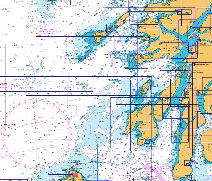
Aids to Navigation Review 2020-2025

Undertaken by the General Lighthouse Authorities

         Commissioners of Irish Lights
          Northern Lighthouse Board
                Trinity House

                                                   2
Section 1 - Index

Section 1 - Index ............................................................................................................. 3
Section 2 - Introduction .................................................................................................... 4
Section 3 – Review Process ............................................................................................... 5
Section 4 – Background to Review & Factors relevant to the Review ....................................... 7
Section 5 – Contacts .......................................................................................................12
Section 6 - References .....................................................................................................13
Section 7 - Abbreviations .................................................................................................14
Section 8 – List of Review Areas .......................................................................................15
Section 9 – Inter-GLA Diagram covering Review Areas ........................................................16
Section 10 – Review of Northern Lighthouse Board Areas (1 – 8) ..........................................17
Area 1 – Isle of Man, North Channel and Clyde .....................................................................17
Area 2 – Mull of Kintyre to Ardnamurchan ...........................................................................19
Area 3 – Ardnamurchan to Barra Head; Cape Wrath to the Flannan Isles .................................21
Area 4 – Scotland North Coast; Orkney Islands (excluding Pentland Firth) ...............................23
Area 5 – Pentland Firth .....................................................................................................25
Area 6 – Shetland Islands ..................................................................................................27
Area 7 – Noss Head to Rattray Head ...................................................................................29
Area 8 – Rattray Head to St Abb’s Head ..............................................................................31
Section 10 – Review of Trinity House Areas (9 – 14) .............................................................33
Area 9 – Berwick to Sizewell ..............................................................................................33
Area 10 – Sizewell to Shoreham .........................................................................................35
Area 11 – Shoreham to Lyme Regis ....................................................................................37
Area 13 – Bude to Cardigan ...............................................................................................41
Area 14 – Cardigan to Silloth .............................................................................................43
Section 10– Review of Irish Lights Areas (15 -21) ................................................................45
Area 15 - Fastnet to Tuskar ...............................................................................................45
Area 16 - Tuskar to Baily ...................................................................................................46
Area 17 - Baily to St John's Point Down ...............................................................................48
Area 18 - St John's Point Down To Rathlin Island ..................................................................50
Area 19 - Rathlin East to Tory Island...................................................................................52
Area 20 - Tory Island to Loop Head ....................................................................................54
Area 21 - Loop Head to Fastnet ..........................................................................................56
Dinish Island Directional Hand over to LLA ........................................................................57
Section 11 –Changes made during continuous AtoN Review Process
2015-2020 ......................................................................................................................58
Section 12 - GLA – Navigational Risk Assessment ...............................................................60
Section 13 – Flow Diagrams and Risk Assessment Forms .....................................................61
Section 14 – Definitive Lists of all Aids to Navigation ...........................................................63

                                                                                                                                3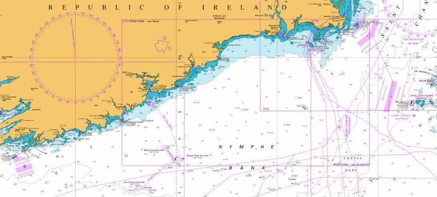
Section 2 - Introduction
The three General Lighthouse Authorities (GLA); the Commissioners of Irish Lights, the Northern
Lighthouse Board and Trinity House, operate an integrated aids to navigation service throughout
the coastal waters of Britain and Ireland. This service is delivered to recognised standards set by
the International Association of Marine Aids to Navigation and Lighthouse Authorities (IALA) so as
to meet the responsibilities of the British and Irish Governments under the International Maritime
Organization (IMO) Safety of Life at Sea Convention (SOLAS).
The joint Mission Statement of the GLA is:
“To deliver a reliable, efficient and cost effective Aids to Navigation
Service for the benefit and safety of all mariners.”
This is the fifth 5 yearly Review whereby a formal, simultaneous and coordinated assessment of
all the Aids to Navigation (AtoN) under their responsibility is undertaken by the three GLA. This
Review addresses the current and anticipated future requirements for the safe passage of domestic
and international shipping. It also addresses the requirements of other mariners, such as fishing
and leisure users.
The mandate of the GLA and their statutory responsibility is to provide sufficient aids to navigation
to mitigate risks and protect the marine environment. The GLA work with Government, shipping
interests, and other stakeholders to minimise this cost.
The GLA Marine Aids to Navigation Strategy to 2030 (2030 Navigating the Future), forms the
strategic foundation of this Review. Various policy considerations are contained in the GLA Joint
Navigation Requirement Policies (JNRP-2012) and the Marine Navigation Plan (2016). These
documents expand the strategic view.
As detailed in the AtoN Review Policy document which is contained in the JNRP, it should be
recognised that the nature of shipping and navigation continues to change. Consequently the AtoN
infrastructure to assist safe passage requires periodic review to ensure that the AtoN provided are
appropriate. The requirement and the rate of change vary geographically depending on a number
of factors. Within the GLA areas it is considered that a Strategic Plan and Operational Plan (i.e. 5
year AtoN Review) caters for the longer and short term review requirements.
The principle applied is that the amount, mix and nature of AtoN provided are:
Commensurate with the volume of and nature of the traffic
Appropriate for the degree of risk
Integrated and cost-effective
Compliant with internationally accepted standards
The priorities in applying such principles are:-
The safety of life at sea
Safe passage of shipping
The protection of the marine environment
The maintenance of trade
Each AtoN has been studied in isolation, as well as in relation to the other AtoN in its vicinity which
is referred to as the "mix" of AtoN. The review has been carried out based solely on the navigational
requirements.
The GLA provide AtoN for all classes of mariners; the traffic mix comprises vessels of many sizes
and performance levels. Across all classes, there is an overwhelming reliance on GPS with its
inherent vulnerabilities to man-made interference and space weather. The GLA have concerns that
lessons have not been learned from over reliance on electronic navigation and also that Cyber
Security is a major threat.
As environmental drivers gain prominence in the UK and Ireland, the GLA act not only to preserve
the marine environment within which the ships operate but also with a wider economic and climate
conscious mind-set.
4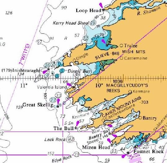
Section 3 – Review Process
3.1 Start of Review Process
The 2020 AtoN Review was formally announced at the Joint Users Consultative Group (JUCG)
meeting in Edinburgh on 8th May 2019.
3.2 Conduct of the 2020 Review
Each GLA has carried out a review of its own area of responsibility. Where the boundaries of two or
even all three, GLA meet, a concerted view has been necessary. Thus, for example, in the North
Channel/Isle of Man area, all three GLA have combined to produce the recommendations covering
these areas.
In producing the recommendations contained in the Review, the GLA have:
Carried out their own internal study of the AtoN in their area of responsibility.
Followed an identical review process.
Completed identical Risk Assessment Forms and signoff procedures.
Assessed AtoN individually and as part of a “mix”.
Carried out cross-border discussions with other GLA.
Involved the Users in initial discussions and invited comment.
Formally briefed the individual GLA User Consultative Groups on the recommendations.
3.3 Peer Review
In this review, the three GLA have each presented their draft recommendations to the others for
assessment, cross examination and comment.
3.4 User Consultation
Users were formally consulted during 2018/2019 both for input into the Review and comment on
the draft proposals by distribution of Notice to Mariners (NtoM), press release and targeted user
consultation. A number of the proposed changes contained in the Review have been incorporated
as a direct result of user response obtained to date on specific areas of interest.
3.5 Transfers to LLAs and period of transfer
The changes recommended in this Review are generally intended to be completed within the period
of the Review. In the case of transfer of AtoN to a Local Lighthouse Authority (LLA) it is possible
that all recommendations may not be fully completed within the period. It is important that there
is an orderly transfer of such AtoN and that they are transferred in good condition. In the case of
recommendations on range reductions, unless there is a significant cost saving to be achieved,
these will be completed as part of the normal Enginering Projects programme.
3.6 The Principles applied in determining the Navigational Requirement
In this Review, the following principles are applied.
Generally, Visual and Radio Aids to Navigation can be considered as complementary to and
an essential back-up system to Global Navigation Satellite System (GNSS).
Physical aids are important for both offshore and inshore spatial awareness and hazard
marking.
Generally, having one AtoN in view is acceptable.
A maximum nominal range of 18 miles is considered sufficient for most lighted Visual Aids
to Navigation.
Leading lights, sectored lights and Precision Directional Lights (PDL) remain important.
Fog signals are no longer considered to be AtoN and are only used as hazard warning signals.
5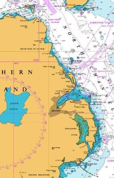
More use can be made of sequential and synchronised lights.
3.7 Methodology
As in previous Reviews, the coasts of UK and Ireland have been divided into 21 coastal areas. Areas
1 to 8 are the responsibility of Northern Lighthouse Board. Areas 9 to 14 are the responsibility of
Trinity House. Areas 15 to 21 are the responsibility of Irish Lights.
Both Qualitative and Quantitative data has been used as far as possible to inform the overall
assessment of requirements.
AIS analysis has been used as much as possible to determine the volume, type, tracks and
pattern of traffic, and when carrying out risk assessments.
Collisions & Groundings data provided by the MCA has been used to support risk assessment.
Use has been made of Geographic Information Systems (GIS) overlay tools to assist in the
overall assessment of requirements.
Information has been incorporated from RYA cruising routes and other sources affecting the
safety of the Mariner, including proposals for Oil and Gas, Renewable Energy and
Aquaculture developments.
Each AtoN has been subject to a navigational assessment under the headings below. Where
changes are recommended, a full written Risk Assessment (RA) is carried out.
A Risk Assessment may be applied either to individual AtoN or to a group of interrelated
AtoN.
The GLAs have cross checked their RAs and recommendations with each other.
Assessment of AtoN and the format of RAs carried out include the following considerations:
1 Is the AtoN a significant part of a group of Aids which will be affected by the change?
2 Assessment of local bathymetry against the proposed change?
3 Frequency and accuracy of hydrographic surveys?
4 Traffic density, type, size, draft and speed.
5 Traffic patterns to be considered in relation to conflict between route and types of vessel.
6 Existing obstructions and developments.
7 Planned new obstructions or developments.
8 IMO international and local charted traffic routing measures.
9 Port & Local Information Systems e.g. VTS, Information Service, Sailing Directions and
Local NtoMs.
10 Local knowledge of users including the availability of pilotage.
11 Requirement in prevailing weather conditions including luminous range, sea conditions
and background lighting.
12 Accident or incident history recorded for this station.
13 Any other considerations.
6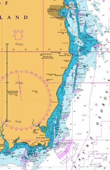
Section 4 – Background to Review & Factors relevant to the Review

4A     Navigational Issues

4A.1 Modern Navigation
The bridges of most modern commercial ships are fitted with a number of key navigational aids,
which rely on inputs from GNSS for position and timing. GNSS has brought readily available and
accurate position fixing to millions and has changed the manner in which the mariner conducts a
voyage. An integrated bridge has GNSS inputs to radar, electronic chart, autopilot, Automatic
Identification System (AIS), Global Maritime Distress and Safety System (GMDSS) Voyage Data
Recorders, Emergency Position Indicating Rescue Beacon (EPIRB) and more.

However, there remains concern that in the maritime sector there is such high reliance on GPS for
positioning fixing and timing due to the known vulnerability of the system to accidental or malicious
interference. Glonass, and Galileo, the Russian and European equivalents of GPS, and other planned
systems will only ameliorate concerns to a limited degree. The similarities of the GNSS space based
signals mean that they suffer from the same weaknesses. It is essential to retain a mix of
complementary systems, as the fundamental principle of marine navigation is not to rely on a single
source of navigation information when alternative sources are available. A range of resilient
Position Navigation and Timing (PNT) solutions are being considered.

Given that it is estimated that over 90% of UK and Irish trade is carried by sea and our waters are
some of the busiest in the world, the potential for accidents, disruption of trade, environmental
damage and loss of life resulting from interruption to the GNSS signals is of great concern.

4A.2 e-Navigation
e-Navigation is the next evolutionary step towards safer navigation. The IALA definition is:
“e-Navigation is the harmonised collection, integration, exchange, presentation and analysis of
maritime information onboard and ashore by electronic means, to enhance berth-to-berth
navigation and related services, for safety and security at sea and protection of the marine
environment”

The GLA vision for e-Navigation is that it will enable innovative solutions for the:
•      cost effective integration and validation of the diverse information, available from multiple
       sources, needed for safe, secure, efficient and environmentally friendly marine navigation;
•     reliable transmission of that information to appropriate users in a timely manner using the
optimum communications channels; and
•      coherent presentation of the information to the user, while avoiding information overload.

e-Navigation will build on existing services to facilitate the controlled, phased and prioritised
introduction of new technology, systems and services for the benefit of all mariners.
The GLA approach to e-Navigation will focus on the early delivery of benefits through the integration
and delivery of data that is already available, together with the development of future solutions.
To achieve this, the GLA will work with other UK and Irish organisations involved in e-Navigation
to encourage a coherent, holistic and efficient approach to innovation, data and infrastructure
integration and delivery of information to users.

4A.3 Human Factors.
The IMO e-Navigation Strategic Implementation Plan inclues provision for Guidelines on Human
Centered Design, Usability Testing, Evaluation and Assessment and Software Quality Assurance.
There is an identifiable increase in marine accidents resulting from misuse of and over reliance on
electronic display systems and technology for navigation and passage planning. In a number of
instances a series of clearly identifiable aids to navigation have been ignored in the run up to a
serious incident. Increased attention needs to be paid to human factors issues relating to the use
of aids to navigation by modern mariners. Consideration needs to be given to dissemination of

                                                                                                    7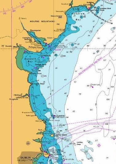
information relating to AtoN as well as guidance on the expected performance and appropriate use
of different types of AtoN and improving the presentation of information relating to the use of such
AtoN in the context of effective bridge resource management. The GLA will continue to work through
IALA, IMO and other international bodies to develop appropriate guidance on these issues.

4B     Marine Traffic and Density

4B.1 Aquaculture
Applications for aquaculture licenses are made to the various Government Departments responsible
for such activities for almost every coastal region. Long-established salmon farming has been
augmented by the cultivation of other fin-fish, shellfish and seaweed. The GLA are consulted by the
responsible Government Departments, regarding the impact of aquaculture on the safety of
navigation in specific coastal areas. This includes the marking and lighting of fish farms, floating
structures, cages and trestles. Effective Maritime Spatial Planning will need to be considered in a
navigational context.

4B.2 Fishing
The fishing industry remains an important industry throughout Britain and Ireland, both inshore
and off shore. Fishing vessel traffic and its interaction with other users is an important
consideration in determining AtoN provision.

4B.3 Marine Leisure and Tourism
In recent years the marine leisure industry has grown significantly. Satellite navigation systems,
electronic chart systems and even integrated navigation systems are common but not always fully
understood as to the degree of accuracy provided and the possible vulnerabilities. Furthermore,
the widespread availability of GNSS receivers, including Smart Phone Apps, is increasingly
encouraging mariners of all classes to navigate either closer inshore or closer to dangers,
sometimes doing so in conditions of darkness and reduced visibility where they would not have
previously ventured.

Since the last review in 2015 the UK and Ireland have seen an increase in cruise tourism, with
increasing numbers of cruise vessels calling to ports, harbours and anchorages around our coasts.
Parallel to this upsurge in vessel numbers there has also been an increase in vessel size and
consequently in the number of passenger per vessel. Present indications are for cruise tourism
around UK and Ireland to develop and diversify. This diversification has already been seen with the
arrival of exploration cruise tourism calling to more remote and previously unexplored ports, loughs
and estuaries around the coast. As a result, many Local Lighthouse Authorities (LLA) are having to
re-access the navigational requirements in these areas, by developing and adapting traditional AtoN
and utilising advances in technology in order to respond to the navigational safety needs of the
cruise industry. The GLA has been working with LLA to assist them in responding to this changing
need while also reviewing the general AtoN provision in line with this trend in shipping.

4B.4 Offshore Renewable Energy Installations (OREIs)
There continues to be a proliferation of applications to develop offshore windfarm sites around our
coasts; this trend is set to increase as the UK and Ireland Governments set higher targets for power
generation from renewable sources. Many more windfarms are in the planning or consent stage.
These sites present a particular challenge to the GLA to ensure they are marked correctly and do
not impede safe navigation of vessels. This is especially so while in the construction phase.

In addition, there are experimental wave and tidal energy devices with numerous applications for
such sites. These sites are also challenging to mark, particularly wave generators that are often
difficult to detect due to low freeboard.

4B.5 Routing Measures and Traffic Separation Schemes (TSS)
The International Maritime Organization is the specialist agency of the United Nations responsible
for maritime safety. It is the only international body that can sanction measures on an international
level concerning ship routeing and areas to be avoided by ships or certain classes of ships.

                                                                                                   8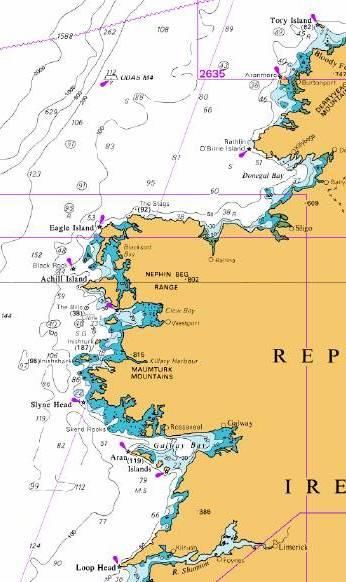
Submissions regarding route proposals or areas to be avoided are the responsibility of Government,
i.e. The Department of Transport, Tourism and Sport (DTTAS) in Ireland and the Department for
Transport (DfT) in the UK. In the UK this role has been delegated to the Maritime and Coastguard
Agency, which is an Executive Agency of the DfT.

There are ten TSS adopted in the UK and Ireland. These are situated in the Approaches to The
Humber, Dover Straits, the English Channel, Scilly Isles, Smalls, Anglesey, North Channel (Rathlin
Island), Fastnet, Tuskar and The Little Minch. Associated with TSS there may also be Inshore Traffic
Zones (ITZ).

A Deep Water Route for tankers exists West of the Outer Hebrides.

4C     Technology Issues

4C.1   DGPS
The GLA Differential GPS infrastructure was originally installed in 1998, largely to mitigate the
effects of selective availability, a purposeful error introduced to degrade the accuracy offered to
civilian GPS users. Selective Availability was turned off in 2000, following which the main function
of DGPS has been to provide integrity i.e. a real-time warning if a satellite, or the GPS system, was
degraded and unusable.
The GLA DGPS infrastructure was last partially replaced between 2008 and 2014 and the current
equipment is nearing the end of its design life. Since the last system recapitalisation, alternative
technologies such as Satellite-based Augmentation System (SBAS), (European Geostationary
Navigation Overlay Service (EGNOS) across Europe), and Receiver Autonomous Integrity
Monitoring (RAIM) have developed further.
SBAS providers do not currently recognise a maritime user and while SBAS functionality is available
in most receivers, it is not type approved. This is being addressed by the European GNSS Agency
(GSA) and the European Commission (EC). GSA and the EC are considering an EGNOS maritime
service with the GSA seeking to support the standardisation required to enable type approved SBAS
receivers. Both of these aspects are expected to come to fruition around 2021/2022, following
which type approved receivers will potentially enter the market.
RAIM is generally available in most modern maritime GNSS receivers. RAIM requires sufficient
satellites in view to operate correctly and a single GNSS constellation results in periods where there
are insufficient satellites with the required geometry for RAIM to function, although this is limited
to short periods of the day. This is not a problem with multi-constellation GNSS receivers as there
are significantly more satellites available. It is anticipated that multi-constellation GNSS receivers
will become more widely available for purchase.
Finally, it is also noted that commercial augmentation services are available for those mariners that
require high accuracy positioning and/or integrity with performance guarantees.
The GLAs note that while there are IMO performance specifications for marine differential services
and corresponding IEC test specifications for maritime differential receivers, there is no mandatory
carriage requirement for differential receivers. Some vessels opt to carry such equipment based
on their requirements whilst others do not. As such, the decision to mitigate any loss of integrity
resides with the mariner. The absence of a carriage requirement means the owners can make a
choice on how they manage integrity issues.
The GLAs have concluded that the GLA DGPS system is now redundant in view of available
shipborne systems and the GLA DGPS system will be discontinued in March 2022. This long notice
is intended to ensure ship operators and Masters are fully aware of the intention to withdraw the
service and where necessary, move to alternative solutions.
While the DGPS service is being discontinued there will be value in retaining the allocated frequency
spectrum, radio masts and some of the other infrastructure pending clarification of future
requirements.

                                                                                                    9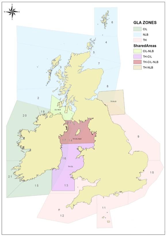
4C.2 Automatic Identification System (AIS)
AIS has been developed as an identification transponder system which can be used for monitoring
ship movements. AIS is mandatory on SOLAS vessels greater than 300grt and some fishing vessels.

Navigational safety can be enhanced by the use of AIS as an AtoN. An AtoN transmitting AIS is
capable of display on the bridge Electronic Chart Display and Information System (ECDIS) and
Radar. Further information is available to the mariner on the status of the AtoN such as its “health”
and position.

It is also possible to use both shore based and floating aids to provide meteorological and
hydrological information.

The GLA have taken into account the fact that the number of Mariners capable of seeing the AIS
AtoN on an appropriate display is increasing.

There are a number of vessels who are not required to carry AIS, including the leisure, fishing and
smaller commercial vessels, however a number of these vessels voluntarily carry AIS.

4C.3 Virtual AIS AtoN
A Virtual AIS AtoN is transmitted from an AIS station to establish an aid to navigation that does
not physically exist. In this case, a digital information object will appear on the navigational system
for a specified location, even though there is no physical AtoN. A nearby base station or AtoN
station could broadcast this message. The AIS message will clearly identify this as a Virtual AIS
AtoN.
Virtual AtoN are particularly useful in time-critical situations and in marking/delineating dynamic
areas where navigational conditions change frequently or in applications where the use of physical
aids is not practical or possible. For example, it may be appropriate to create a virtual AtoN to
mark hazards to navigation on a temporary basis until a more permanent AtoN can be established.
Alternatively, virtual aids to navigation may be established to mark areas where navigation
conditions (for example; channel boundaries, overhead clearance, water levels) change frequently
and would require dynamic marking.
There is however a growing recognition that AIS AtoN can be used on a longer term basis. IMO
MSC.1/Circ.1473 (May 2014) notes that Virtual AIS AtoN should not be used for permanently
marking an object for which Physical AtoN would be possible, but, may be considered for marking
an object or feature where it is difficult or economically unreasonable to establish a Physical AtoN
due to environmental constraints e.g. deep water, harsh sea conditions. Another case of the
permanent application of Virtual AIS AtoN is for example marking a shoal that changes with time
due to current or weather effects; and, where the object or feature is impossible to maintain as
charted because of changes that occur over time.

4C.4 Web Based AtoN
Some small harbours and marinas have entered into commercial contracts with system providers
that display aids to navigation solely on web based navigation systems for the use of their
customers. These include versions of Virtual AIS AtoN licenced by OFCOM and showing correct
MMSI numbers. The GLA are unable to monitor or verify these systems and will not be providing
AtoN in this manner.

4C.5 Light Emitting Diodes (LEDs)
The use of LEDs has been extended to beacons and lighthouses with similar advantages to those
seen on buoys. Off the shelf omnidirectional LED AtoN lights can currently provide a nominal range
of around 18nM. However, ongoing research and development in LED technology is constantly
delivering improvements in light intensity, efficacy and optical technology. It is already evident that
such advances in technology are changing the way in which AtoN lights are designed. Modern LED
AtoN light design is typically based on a modular approach giving advantages in manufacture,
product flexibility and customer choice. If designed properly, a modular approach should also
promote standardisation.

                                                                                                    10
4C.6 Power Sources (Green Energy)
The GLA are commited to continuing to invest in green energy solutions, including solar power,
wind power and alternative fuel sources, for our AtoN.
4D Future Developments
4D.1 Marine Automated Surface Ship (MASS)
The GLA are currently engaging with industry and the established regulatory working group in the
UK in areas such as governance and regulation, codes, operations as well as training and skills in
order to assess the future requirements of MASS.
11Section 5 – Contacts
Any comments or observations on the Review may be sent to the appropriate GLA, as follows:
Comments in respect of Areas 1 - 8
Director of Operations
Northern Lighthouse Board
84 George Street
Edinburgh
Scotland
EH2 3DA
Email: navigation@nlb.org.uk
Comments in respect of Areas 9 - 14
Director of Navigational Requirements
Trinity House Lighthouse Service
Trinity House
Tower Hill
London
EC3N 4DH
Email: navigation@trinityhouse.co.uk
Comments in respect of Areas 15 - 21
Director of eNavigation and Maritime Services
Commissioners of Irish Lights
Harbour Road
Dun Laoghaire
Co. Dublin
A96 H500
Ireland
Email: info@irishlights.ie
12Section 6 - References
The following publications have been referred to during completion of the Review. The most recent
version of each document has been used in each case.
EU Directive for Maritime Spatial Planning (Aug 14).
Admiralty Charts, UKHO.
Admiralty List of Lights, Volume A, NP74, UKHO.
Admiralty List of Radio Signals, Volume 2, NP282, UKHO.
Admiralty Sailing Directions, UKHO.
2030 Navigating the Future, GLA, 2016.
Joint Navigation Requirements Policy, GLA, 2012.
Marine Navigation Plan 2016 to 2030 GLA 2016.
Corporate Plans of Irish Lights, Northern Lighthouse Board, Trinity House.
Safe Seas – Connected Coasts, Irish Lights Strategy 2018-2023
UK Port Freight Statistics, DfT, 2018
UK Sea Fisheries Statistics, MMO, 2017.
IALA Recommendations, Guidelines and Standards.
IMO Circulars.
13Section 7 - Abbreviations
ALL Admiralty List of Lights
AIS Automatic Identification System
AtoN Aid(s) to Navigation
BA British Admiralty
DGPS Differential Global Positioning System
DfT Department for Transport (UK)
DTTAS Department of Transport, Tourism and Sport (ROI)
DR Dead Reckoning
ECDIS Electronic Chart Display and Information System
eLoran Enhanced Loran
e-Nav e-Navigation
EPIRB Emergency Position Indicating Radio Beacon
EU European Union
F Fixed
Fl Flashing
G Green
Galileo European Satellite Navigation system
GLA General Lighthouse Authorities
GLONASS Global Navigation Satellite System (Russian)
GMDSS Global Maritime Distress and Safety System
GNSS Global Navigation Satellite System
GPS Global Positioning System
Irish Lights Commissioners of Irish Lights
IMO International Maritime Organization
Iso Isophase
ITZ Inshore Traffic Zone
L Fl Long Flash
Ldg Lts Leading Lights
LED Light Emitting Diode
MMO Marine Management Organisation
MKD Minimum Keyboard and Display (AIS)
nM Nautical Mile
NLB Northern Lighthouse Board
Occ Occulting
OREI Offshore Renewable Energy Installations
PDL Precision Directionional Light
PNT Position, Navigation and Timing
Q Quick Flashing
R Red
Racon Radar Beacon
ROI Republic of Ireland
SAR Search and Rescue
SOLAS Safety of Life at Sea (IMO Convention)
TH Trinity House
TSS Traffic Separation Scheme
UK United Kingdom
W White
14Section 8 – List of Review Areas
Area 1 Isle of Man, North Channel, Clyde
Area 2 Mull of Kintyre to Ardnamurchan
Area 3 Ardnamurchan to Barra Head; Cape Wrath to The Flannan Isles
Area 4 Scotland N. Coast, Orkney Is (exc. Pentland Firth)
Area 5 Pentland Firth
Area 6 Shetland Islands
Area 7 Noss Head to Rattray Head
Area 8 Rattray Head to St Abbs Head
Area 9 Berwick to Sizewell (Sub-divisions B1, B2, B3)
Area 10 Sizewell to Shoreham (Sub-divisions C1, C2, C3)
Area 11 Shoreham to Lyme Regis (Sub-divisions D1, D2)
Area 12 Lyme Regis to Bude (Sub-divisions E1, E2)
Area 13 Bude to Cardigan (Sub-divisions F1, F2, F3)
Area 14 Cardigan to Silloth (Sub-divisions G1, G2)
Area 15 Fastnet to Tuskar
Area 16 Tuskar to Baily
Area 17 Baily to St John’s Point Down
Area 18 St John’s Point Down to Rathlin Island
Area 19 Rathlin East to Tory Island
Area 20 Tory Island to Loop Head
Area 21 Loop Head to Fastnet
15Section 9 – Inter-GLA Diagram covering Review Areas
Navigation Review Area with GLA Contiguous Zones
16Section 10 – Review of Northern Lighthouse Board Areas (1 – 8)
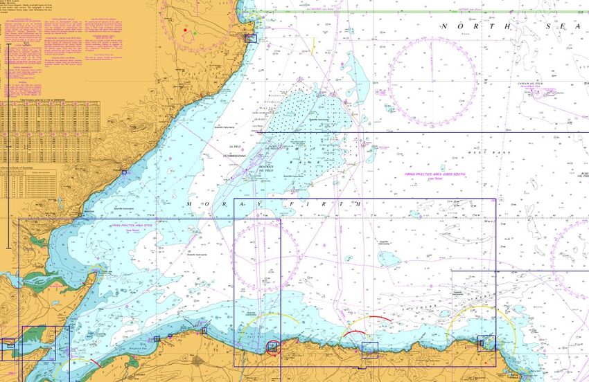
Area 1 – Isle of Man, North Channel and Clyde
OVERVIEW
The Isle of Man, lying mid-way between the coasts of Cumbria and Northern Ireland, mainly
consists of mountains and hills with east-west valleys. The North of the island is low lying and
flat with banks and shallows off shore whilst the southern end of the island is heavily indented
by small bays with isolated offshore drying rocks.
The south west coast of Scotland from Solway to Kintyre starts at the most eastern part of the
Solway as low lying with shallow waters, numerous drying banks and shifting sands. As the coast
runs west it becomes mainly bold and rocky, indented by bays rising to steep cliffs at the Mull
of Galloway and along the Rhinns edging the North Channel, which is deep and unobstructed but
experiences strong tidal flow. The Firth of Clyde, also deep and generally unobstructed, has a
high and rocky coast and some sandy beaches on its eastern shore. The Firth has a number of
rocky islands rising from its deep waters; Arran, Sanda and Pladda on its N and W edge and
Ailsa Craig in the middle of an otherwise clear channel.
Principal ports in the area are Douglas serving the needs of the Isle of Man with Ro-Ro and fast
ferry, local fishing and coastal bulk cargoes. Kirkcudbright remains an important fishing port for
shell fish. The new Loch Ryan Port and Cairnryan handle Ro Ro and HSC ferries for Northern
Ireland (5.4 million tonnes /year in 2018) whilst the Clyde ports handle container traffic, coal
imports, crude oil imports, petroleum product exports and bulk materials totalling 9.1 million
tonnes per year along with Cruise and MOD vessels. Campbeltown supports timber exports,
fishing and small general cargo vessels, in addition to a NATO fuel jetty and a ferry service to
17Ardrossan. Smaller ports in the area serve the leisure industry, smaller fishing vessels and
occasional coastal trade.
There is significant vehicle ferry traffic, linking Arran, Bute and Cumbrae to the mainland, and
connecting the peninsulas of the Upper Firth of Clyde.
Traffic of all types (passenger, cargo, leisure and Government) and sizes in significant quantity
operate throughout this area, either departing or arriving at local ports or as through traffic
transiting the Irish sea, passing west of the Isle of Man and through the North Channel in both
directions. Additionally, traffic proceeds to and from major Irish and English ports, passing south
and north of the Isle of Man. Fishing occurs throughout the area. There are a substantial number
of leisure users who sail in the Firth of Clyde, with smaller numbers in Loch Ryan, the Solway
Firth and Isle of Man.
Marine Protected Areas (MPA) include Special Areas of Conservation (SAC) in the Solway Firth
and Luce Bay; Special Protection Areas (SPA) at Ailsa Craig, the Inner Clyde Estuary, and the
Upper Solway Flats and Marshes; and Nature Conservation MPAs (NCMPA) at the Clyde Sea Sill,
South Arran, and Upper Loch Fyne and Loch Goil. In the Isle of Man there are five Fishery closed
or restricted areas, and five Marine Nature Reserves around Ramsey.
TSS: There is no TSS or routing measures in this area.
AtoN provided: 22 lights, 17 Buoys, 3 Racons, 3 unlit Beacons, 5 AIS.
Future developments in the area that may affect AtoN provision include the potential siting of a
windfarm East of the Isle of Man.
PROPOSED CHANGES FOLLOWING 2020 REVIEW
Point of Ayre Re-engineer with minimum 18nM range (19nM)
Corsewall Re-engineer with minimum 18nM range (22nM)*
Loch Ryan Re-engineer; maintain existing 12nM red light
Pladda Re-engineer; maintain existing 17nM range
Little Ross Review conspicuity of 12nM light
AIS & Virtual AIS Add to Point of Ayre and Corsewall
Capability
* = carried forward from 2010 Review
18Area 2 – Mull of Kintyre to Ardnamurchan
OVERVIEW
The West of Scotland presents an almost uninterrupted succession of deep indentations, fronted
by bold rocky cliffs and headlands forming islands, narrows and sea lochs. Drying rocks and reefs
are plentiful quite often with deep navigable waters immediately adjacent. The Mull of Kintyre
to Ardnamurchan coast line is no exception; exposed directly to the Atlantic Ocean and the full
force of winter gales, the coast is frequently obscured by low cloud and driving rain. Strong tidal
streams, and eddies can be experienced in narrows and inshore.
Principal ports in the area are Oban and Fort William (Corpach). The former provides a major
ferry hub for routes to the islands, fishing, small numbers of general bulk cargo, fish farm support
(feed and smolt) and frequent seasonal cruise vessel traffic along with a substantial number of
leisure craft. Corpach handles bulk timber and quarry products while Fort William at the South
end of the Caledonian Canal sees significant leisure traffic and some cruise vessel visits.
Throughout the area particularly on the islands there are a number of smaller ferry and coaster
berths, fishing harbours and leisure craft moorings & marinas. A quarry terminal at Glensanda
operates large bulk carriers (exporting 5.9 million tonnes in 2018).
Local lifeline ferries operate Kennacraig to Port Ellen and Port Askaig; Oban to Colonsay, Port
Askaig, Craignure, Lismore, Coll, Tiree & Barra; across the Sound of Mull and to Iona and Gigha.
There are further council operated ferries at Corran, Lismore, Luing, Easdale, Fort William and
Jura.
19Traffic routes have not substantially changed since 2015, however there has been a significant
increase in vessels (ferries, leisure, cruise) visiting Oban Bay in particular (40,000 vessel
movements in 2017). Traffic of all types: passenger ferry, cargo, leisure and Government in
small but significant quantity operate throughout this area either departing or arriving at local
ports providing essential transport for the economy of the area.
Through traffic falls into two types. Larger vessels remain within the TSS to/from the North
Channel and keep to the SW of Skerryvore before turning north to the Minch or heading
northwest for the deep water route or west. Smaller coastal vessels often choose to pass through
the sound of Islay and to the east of Coll and Tiree. Fishing occurs throughout the area. The
area is popular with adventurous leisure sailors and new marina developments have been
implemented in Oban, Tobermory and Ulva (Mull).
Marine Protected Areas include SAC in the Firth of Lorn, SE Islay, Sunart, Tayvallich and
Treshnish Isles; SPAs at Islay, Colonsay and Tiree; and NCMPA in Loch Creran, Loch Sunart and
South to the Sound of Jura, and Loch Sween. There are Historic MPAs at Dartmouth, Duart Point
and Iona.
TSS: A TSS lies between Rathlin Island and Mull of Kintyre for vessels approaching/exiting the
North Channel.
AtoN provided: 44 lights, 58 Buoys, 2 Racons, 2 unlit Beacons, 7 AIS.
Future developments in the area that may affect AtoN provision include tidal energy sites in the
Sound of Islay and to the SW of Islay which may restrict depths for some vessels which currently
use the area.
PROPOSED CHANGES FOLLOWING 2020 REVIEW
Dubh Artach re-engineer with a minimum 18 nM range
Skerryvore re-engineer with a minimum 18 nM range*
Bhanarach Rocks (Gigha) Establish an East Cardinal Mark buoy
Rubha Cuil-cheanna Establish a sector light for southbound traffic
(Corran Narrows SE)
Loch Spelve Reinstate (unlit) starboard hand beacon
* = carried forward from 2010 Review
20Area 3 – Ardnamurchan to Barra Head; Cape Wrath to the Flannan
Isles
OVERVIEW
Between Ardnamurchan and Cape Wrath the almost uninterrupted succession of deep
indentations, fronted by bold rocky cliffs and headlands, forming islands, narrows and sea lochs
continue. Strong tidal streams and eddies can be experienced in narrows and inshore.
A chain of about 30 islands known as the Hebrides lies parallel and a short distance from the
mainland. These islands are in two groups the Outer and Inner Hebrides separated by the Sea
of the Hebrides and the Little Minch. Further north the Outer Hebrides are separated from the
mainland by the North Minch. The outer islands are exposed to the Atlantic Ocean. To the west
of the Outer Hebrides, which are generally low lying, the coastal bank extends up to l5 miles
offshore and in places rock pinnacles extend beyond the bank. Outside of the deep water route
surveys are incomplete. The passage between the Inner and Outer Hebrides affords some
shelter from the Atlantic but depths within the Little Minch are very irregular and several banks
some of which are extensive lie across the NE entrance. Consequently traffic routing and
reporting measures are in place. The Little Minch in bad weather forms a dangerous sea area
due to the wind, tidal streams and uneven nature of the bottom producing high and turbulent
seas. The sound of Harris provides a route from Little Minch to the Atlantic for coastal craft.
Throughout the area there are numerous small ports and harbours supporting the general local
economy or specific operation where direct road access is poor. Collectively they provide for
significant levels of trade. Ports such as Mallaig, Ullapool and Stornaway provide for ferry
terminals for routes to the islands, fishing, coastal general bulk cargo, fish farm support and
frequent seasonal cruise vessel traffic. Timber is exported from mainland ports such as Kishorn
with substantial quarry traffic also occurring. Local life line ferries operate Mallaig to South Uist,
21Armadale, Eigg, Muck, Canna & Rhum; Ullapool to Stornaway; Uig to Tarbert and Lochmaddy;
Berneray to Leverburgh; Oban to Castlebay and Barra to Eriskay, with a winter service also
linking Mallaig and Lochboisdale. There are also local ferries operating in Loch Nevis and between
Glenelg and Kylerhea (Skye).
Traffic patterns have not substantially changed since 2015 other than the re-routing of the
Lochboisdale ferry from Oban to Mallaig, and a significant increase in cruise vessels visiting the
area. Traffic of all types - passenger ferry, cargo, leisure and Government - in small but
significant quantities operate throughout this area either departing or arriving at local ports
providing essential transport for the economy of the area. Throughout the area but particularly
in the southern half there is substantial seasonal leisure craft activity. Through traffic consists
of large and smaller crude and product tankers, to and from North Sea and Flotta, Scapa and
the Forth, oilfield support vessels repositioning to and from the North Sea, seasonal cruise ship
traffic up to and including Queen Mary II, Coaster trade to/from Orkney, Shetland or east coast
ports, or Scandinavia. The routing measures for the Minch and west of the Hebrides largely
govern through traffic patterns. Laden tankers over 35000 DWT use the deep water route west
of the Hebrides but when in ballast often choose to navigate through the Minch north bound. All
other traffic generally uses the Minch north and south bound. Fishing occurs throughout the
area.
The former oil rig construction yard at Kishorn has been re-developed to attract renewable
energy work and platform refurbishment facilities. Fish farm feed is transported from both
Kishorn and a new feed mill at Kyleakin. A new port facility is planned for Glumaig at Stornoway
to attract large cruise vessels and renewable energy developments. Marina developments have
been implemented in Castlebay, Lochboisdale, Lochmaddy, Stornoway and Kyle of Lochalsh.
Marine Protected Areas include SAC in Rum, Monach Isles, North Rona, Sound of Barra, South
Uist, St Kilda, Loch Maddy, Loch Eport, the Sound of Arisaig, Loch Roag. Loch Laxford, Loch
Moidart, Ascrib & Dunvegan, East Mingulay and the Inner Hebrides and Minches; SPAs at the
Flannan Isles, St Kilda, the Shiant Isles, North Uist, South Uist, Mingulay & Berneray, Cape
Wrath, Handa, Canna & Sanday and Rum; and NCMPA in Lochs Duich, Long & Alsh, the Monach
Isles, the Small Isles, Wester Ross and Loch Carron. There are also Historic MPAs at Drumbeg,
Mingary Point and Kinlochnervie.
TSS: There is a TSS at Neist Point to separate north and south bound traffic in the Little Minch.
IMO approved routing measures are in place in the Little Minch and west of the Outer Hebrides.
AtoN provided: 58 lights, 64 Buoys, 9 Racons, 12 unlit Beacons, 21 AIS.
PROPOSED CHANGES FOLLOWING 2020 REVIEW
Butt of Lewis Re-engineer with a minimum 21nM range; discontinue
DGPS service with effect from 2022
Cape Wrath Re-engineer with a minimum 18nM range
Haskeir Re-engineer with a minimum 18nM range
Hyskeir Re-engineer with a minimum 18nM range
Ornsay Re-engineer, maintain existing 12nM range
Dunvegan Re-engineer as LED sector light
Whale Rock buoy Replace with Virtual AIS AtoN broadcast from St Kilda/
Flannans/Haskeir
Portain (Sound of Harris) Replace buoy with lit beacon
Eileanan Dubha Trial daytime conspicuity switching for use in restricted
(Lochalsh) visibility
AIS & Virtual AIS Add to Neist Point, Eilean Glas and Rubh Re
Capability
22Area 4 – Scotland North Coast; Orkney Islands (excluding Pentland
Firth)
OVERVIEW
The North coast of Scotland from Cape Wrath to Dunnet Head is mainly heavily indented cliffs
with a few off lying dangers inshore.
The Orkney Islands, a group of more than 50 islands separated from mainland Scotland by the
Pentland Firth are mainly low lying except for Hoy. Their coasts are much indented and generally
rocky but there are also extensive sandy beaches especially on the NE side of the group. On the
SW side the coasts consist of steep cliffs in places reaching 300m. About midway between South
and North Ronaldsay the Orkney Islands are divided into two parts by the Stronsay Firth and
Westray Firth which together form a continuous passage running NW and SE linking the Atlantic
to E & W Orkney Islands. Scapa Flow, virtually a small inland sea, lies in the south part of the
group with navigable entrances to the Atlantic and Pentland Firth.
The principal ports in the area lie to the east with the Orkneys dominating, collectively handling
1.05 million tonnes of cargo per annum. This includes ship to ship crude oil transfers which occur
in Scapa Flow. The main ports are Kirkwall and Stromness, but throughout the Orkneys there
are numerous small mixed use ports and harbours supporting the general local economy and
the large number of inter island ferry routes or specific operations. Fishing, coastal general bulk
cargo, fish farm support and frequent seasonal cruise vessel visits along with oil field related
vessels are all part of port activity. Local ferries outside of LLA waters operate Scrabster to
Stromness, Aberdeen to Kirkwall and Stromness, and Gill's Bay to South Ronaldsay. Traffic
patterns have not substantially changed since 2015 other than a significant increase in cruise
vessels visiting the area.
Traffic of all types - passenger ferry, cargo, leisure and Government in small but significant
quantity operate particularly around and to and from Orkney providing essential transport for
the economy of the area, significant numbers of crude oil tankers enter Scapa Flow from the
Pentland Firth. A through route from Pentland Firth via Scapa Flow to Stromness is utilised on
occasion. Traffic along the north coast consists of large and smaller crude and product tankers,
to and from the North Sea and Flotta, Scapa and the Forth, oilfield support vessels repositioning
23to and from the North Sea, seasonal cruise ship traffic up to and including Queen Mary II, Coaster
trade to/from Orkney, Shetland or east coast ports, or Scandinavia. Fishing occurs throughout
the area.
Marine Protected Areas include SAC at Durness, Faraym and Solan Bank; SPAs at North Rona &
Sula Sgeir, Westray, Copinsay, Sule Skerry & Sule Stack, Rousay, Calf of Eday, Marwick Head,
and Sanday; and NCMPA in Papa Westray, Wyre & Rousay Sounds, and North–West Orkney.
TSS: There are IMO routing measures in the Fair Isle Channel to the North of this area; an area
to be avoided by laden tankers is in place around the Orkney Islands.
AtoN provided: 21 lights, 14 Buoys, 2 Racons, 2 unlit Beacons, 8 AIS (including three Virtual
AtoN).
Future developments that will affect AtoN provision post this review include:-
There are several potential tidal and wave energy developments planned around Orkney,
although the number and planned rate of development have both reduced in recent years.
Although the Flotta terminal is in decline, Scapa Flow, as one of the few locations in UK waters
that allow ship to ship transfer of crude oil and petroleum products will remain an important
location for the oil industry. In June 2018 Orkney Harbours issued a draft Masterplan for the
expansion of harbour facilities at Kirkwall, Hatston, Scapa, Stromness, Lyness and a Deep Water
harbour facility within Scapa Flow.
PROPOSED CHANGES FOLLOWING 2020 REVIEW
Start Point Re-engineer, maintain existing 18nM range
Skerry of Ness Re-engineer as LED light with no green sector but precise cut-off
at 090º
24Area 5 – Pentland Firth
OVERVIEW
The Pentland Firth is bordered by the rocky mainland coast to the south from Dunnet Head to
Duncansby Head which is indented by numerous bays and coves. The Orkney Islands provide
its northern boundary with similar rocky coast around Hoy, South Walls and South Ronaldsay.
Within the Firth deep waters are interspersed with the islands of Stroma, Swona and Pentland
Skerries. The latter, with the associated 10 mile long narrow bank substantially reducing depths
results in a funnelling effect. Tidal streams within the firth are renowned and can reach up to 12
knots creating tidal races and eddies which can be dangerous particularly in combination with
adverse weather. Substantial seas occur (wind against tide) in circumstances of strong westerly
or SE winds. Consequently reporting measures are in place and the Firth may be closed to some
or all traffic by HMCG.
The principal port in the area excluding the Orkneys is Scrabster which handled 14,500 tonnes
of fish in 2017, has a Ro Ro facility for the ferry to Stromness and handles local coastal cargoes,
including fuel, timber & rock salt. In addition oil industry vessels utilise the lay by facility and
seasonal cruise vessel visit numbers are growing. An HSC ferry operates between Gills Bay and
St Margarets Hope, with increased capacity as of 2019, and in summer a passenger ferry
operates beteen John O’Groats and South Ronaldsay. The Pentland Firth remains a key route for
UK and international traffic.
Traffic patterns have not substantially changed since 2015 other than a significant increase in
cruise vessels visiting the area. Traffic of all types - passenger ferry, cruise, cargo, and
Government in small but significant quantities operate to and from the Orkneys and Scrabster
via the Pentland Firth. Significant numbers of crude oil tankers enter/leave Scapa Flow via the
Pentland Firth loaded and in Ballast.
Through traffic consists of large and smaller crude and product tankers, to and from the North
Sea and Flotta, Scapa and the Forth, oilfield support vessels repositioning to and from the North
Sea, seasonal cruise ship traffic up to and including Queen Mary II, Coaster trade to/from east
coast ports, or Scandinavia.
Trawling does not occur within the Pentland Firth due to tidal conditions but other fishing occurs
around the islands, and it remains a key route for fishing vessels in transit and landing at
Scrabster.
There are designated Special Protection Areas at North Caithness, East Caithness, and Hoy.
25TSS: There are no TSS or routing measures in the area, an area to be avoided by laden tankers
is in place around the Orkney Islands.
AtoN provided: 7 lights, 0 Buoys, 2 Racons, 1 unlit Beacon, 2 AIS.
Future developments that will affect AtoN provision post 2020 review include:-
Following the establishment of the demonstrator Meygen turbine farm in the Inner Sound, larger
scale tidal energy is proposed for areas of the Firth around Stroma, Duncansby Head and off
South Ronaldsay, The potential for a container Hub port, often hinted at for the Orkneys, is
unlikely to come to fruition in the medium term. Although the Flotta terminal is in decline, Scapa
Flow, as one of the few locations in UK waters that allow ship to ship transfer of crude oil and
petroleum products will remain an important location for the oil industry.
PROPOSED CHANGES FOLLOWING 2020 REVIEW
Pentland Skerries Re-engineer, maintain existing 23 nM range
AIS & Virtual AIS Add to Duncansby Head; establish permanent Virtual
Capability AtoN for Sandy Riddle
26Area 6 – Shetland Islands
OVERVIEW
The Shetland Islands, a group of more than 100 islands, holms and rocks, lie with Sumburgh
Head as their southern extremity and stretch some 60 miles north to Muckle Flugga. The principal
islands are Mainland, Yell and Unst. The Shetland Islands are for the most part relatively high,
undulating, fringed by bold cliffs and separated by narrow sounds. Toward the N end of the
group Yell and Bluemull Sounds both navigable passages run, N&S through the islands between
Mainland and Yell, and Yell and Unst respectively. The high and rocky island of Fair Isle also
forms part of the Shetlands dividing the otherwise deep unobstructed passage collectively known
as Fair Isle Channel between Orkney and Shetland Islands. The NLB is responsible for all but
port AtoN in this area.
Principal ports in the area are Sullom Voe whose oil terminal handles 5.3 million tonnes of cargo
a year, and Lerwick, an important mixed use port serving the needs of the Shetlands population
and the oil industry. Lerwick is the UK's second most important fishing harbour landing some
39,800 tonnes in 2017. The port handles around 5,000 vessels per annum including cruise, Ro
Ro ferry, coastal tankers, pelagic trawlers, fish farm and oil industry support as well as leisure
users. Throughout the Shetlands there are numerous small mixed use harbours such as
Scalloway supporting the general local economy and the large number of inter island ferry
routes, fishing, leisure or specific operations. Ferries operate Lerwick to Kirkwall and Aberdeen.
Numerous Local ferries operate throughout the islands. Fishing and inshore fish farming occur
extensively throughout the area. Oil industry decommissioning activities are expected to
increase in significance in the coming years.
Traffic patterns changes since 2015 have seen a significant reduction in oil traffic and an increase
in cruise vessels visiting the area. Traffic of all types - ferry, cargo, leisure, fishing and fish farm
27and Government - in significant quantities operate throughout this area, inter island or either
departing or arriving at local ports from the Orkneys, mainland Scotland or Scandinavia. There
is significant, and growing, oil industry traffic to the west of Shetland as well as the Northern
North Sea with vessels transiting through the Shetlands and using its ports. There remains
substantial tanker traffic to/from Sullom Voe.
The Fair Isle Channel remains an important route for Scandinavian trade bound for the Atlantic,
and for tankers loaded and in ballast for Sullom Voe or in transit to/from the west.
Marine Protected Areas include SAC at Yell Sound, Mousa, Papa Stour, Hascosay, and Sullom
Voe; SPAs at Foula, Fair isle, Hermaness, Papa Stour, Noss, Fetlar, and Sumburgh Head; and
NCMPA at Fetlar to Haroldswick, and Mousa. There is also a Historic MPA at Out Skerries.
TSS: There are no TSS in the area, IMO approved routing is in place in the Fair Isle channel.
Areas to be avoided by laden tankers are in place around the Orkney Islands, Fair Isle and
Shetland.
AtoN provided: 37 lights, 4 Buoys, 3 Racons, 1 unlit Beacon, 2 AIS.
Future developments that will affect AtoN provision post 2020:-
Sullom Voe, established in the 1970s, originally had a 30 year intended life. A number of
significant AtoN were established specifically for tanker traffic with the intention that these be
discontinued when the terminal ceased to operate. The terminal life has now been extended and
will continue to operate for the foreseeable future. The associated AtoN continue to be required.
PROPOSED CHANGES FOLLOWING 2020 REVIEW
Foula Re-engineer and establish red sector to East (257 - 277)*;
maintain 17nM range
Muckle Flugga Re-engineer with minimum 18nM range*
Out Skerries Re-engineer with minimum 18nM range
Sumburgh Head Re-engineer, maintain existing 23nM range; discontinue
DGPS service with effect from 2022
Esha Ness Re-engineer with minimum 18nM range
Fair Isle North Re-engineer with minimum 18nM range
Fair Isle South Re-engineer with minimum 18nM range*
Hoo Stack Re-engineer with LED sector light and discontinue
Directional light*
Bullia Skerry Reduce range from 5nM to 3nM
* = carried forward from 2010 Review
28You can also read