COMPREHENSIVE PLAN THE CITY OF WESTPORT - Adopted April 28, 1998 Revised February 23, 1999 by Ord. #1189 Last revised (DATE) by Ord - City of ...
←
→
Page content transcription
If your browser does not render page correctly, please read the page content below
THE CITY OF WESTPORT

COMPREHENSIVE PLAN

          Adopted April 28, 1998
 Revised February 23, 1999 by Ord. #1189
 Last revised (DATE) by Ord. #_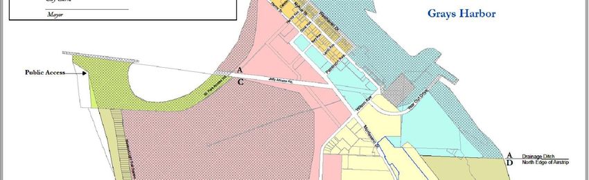
City of Westport
                                                                Prepared by:

                                             City of Westport Administration and
                                                     Planning Commission

                                                        604 N Montesano Street
                                                             PO Box 505
                                                         Westport, WA 98595
                                                           (360) 268-0131

                                                                   Mayor
                                                                Rob Bearden

                                                       City Council:
                                                       Louis Summers
                                                        Tom Aronson
                                                 Kathryn FranzenRose Jensen
                                                       Robert Parnell
                                                       Melissa Huerta

                                                    Planning Commission:
                                                   William Leraas, Chairman
                                                   Rose JensenMark Sanford
                                                          Jim Mankin
                                                           Jeff Pence
                                                        George Prigmore
                                                   Michelle Gooch, Secretary

                                                     Public Works Director
                                                        Kevin Goodrich

City of Westport Comprehensive Plan, 2020 Revision – Draft January 13, 2020        ii
TABLE OF CONTENTS

  Title                                                                       Page Number

  Table of Contents                                                    ii
  List of Appendices                                                   iv
  Plan Update Development Process                                      vi
  Process, Public Involvement and Legislative Adoption.………………………..……………vii

  Chapter 1: Introduction                                                         1
          A. Authority                                                            1
          B. Relationship to the 1999 Comprehensive Plan                          1
          C. Characteristics of Comprehensive Plan                                1
             1. Comprehensiveness                                                 1
             2. Long Range                                                        2
             3. Flexibility                                                       2
             4. Community Participation and Input                                 2
          D. Purpose                                                              2
             1. General Welfare                                                   2
             2. Coordination                                                      2
             3. Policy Statement                                                  2
             4. Communication                                                     3
          E. Definitions                                                          3
             1. May, Should, and Shall                                            3
             2. Goals, Objectives, and Policies                                   3
             3. Appropriate                                                       3
          F. Implementation                                                       3

   Chapter 2: Plan Organization                                                   5

   Chapter 3: Overall Goals and Objectives                                        8
                    Introduction                                                  8
                    Goals                                                         8
                    Objectives                                                    8

   Chapter 4: Land Use Element                                                    10
                    Introduction                                                  10
               A.   Overall Goals and Objectives                                  10
               B.   Residential Land Use                                          12
               C.   Commercial Land Use                                           13
               D.   Industrial Land Use                                           14
               E.   Public and Semi-Public Land Use                               15
               F.   Recreation                                                    16
               G.   Land Use Policies                                             17
               H.   Groundwater, Stormwater Runoff/Drainage                       18
                          Ground Water                                            18
                          Stormwater/Drainage/Flooding                            19

City of Westport Comprehensive Plan, 2020 Revision – Draft January 13, 2020                 iii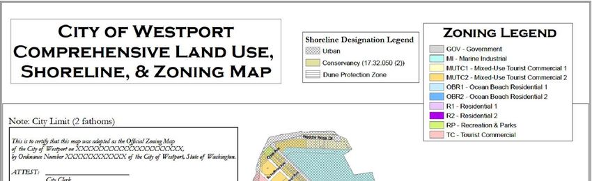
Title Page Number
I. Land Use Designations and Land Use Plan Map 20
1. Residential (R1and R2) 21
2. Ocean Beach Residential (OBR1 and OBR2) 21
3. Mixed-Use/Tourist Commercial (MUTC1 and MUTC2) 21
4. Tourist Commercial (TC) 22
5. Marine Industrial (MI) 22
6. Recreation and Parks 22
7. Government Lands 22
8. Shorelines 22
a. Urban shoreline 23
b. Conservancy 23
c. Natural shoreline 23
J. Process 23
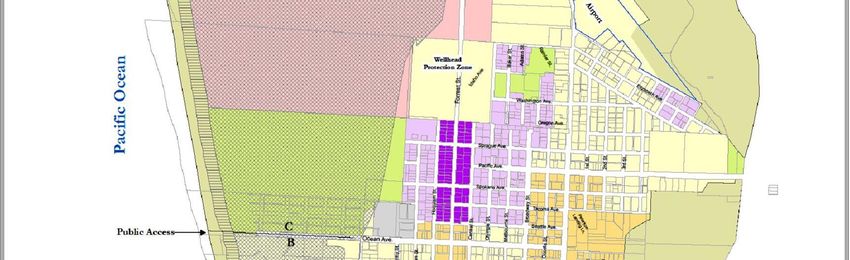
LAND USE PLAN MAP AND DESIGNATIONS Reference-Appendix A (p48)
Chapter 5: Transportation, Circulation, and Telecommunications 24
Introduction 24
Goals 25
Objectives 26
Policies 27
Airport Circulation 28
Goals 28
Objectives 29
Policies 29
TRANSPORTATION AND CIRCULATION ELEMENT MAP Reference-Appendix B
Chapter 6: Economic Development Element 30
Introduction 30
Goals 30
Objectives 31
Policies 31
Chapter 7: Community Identity and Natural Resources Element 34
Introduction 34
Goals 34
Objective 34
Policies 35
Chapter 8: Area-Wide Development Element 38
Introduction 38
Goals 38
Objectives 39
Policies 39
City of Westport Comprehensive Plan, 2020 Revision – Draft January 13, 2020 iv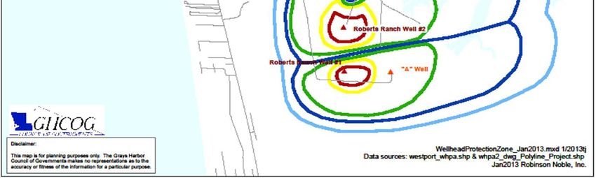
Title                                                                           Page Number

       Chapter 9: Shoreline Goals and Policies                                         41
                    SHORELINE MASTER PROGRAM Reference-Appendix C

       Chapter 10: Health and Well-Being Element                                       42
                    Introduction                                                       42
                    Goals                                                              42
                    Objectives                                                         43
                    Policies                                                           43

       Chapter 11: Implementation                                                      44
                    Introduction                                                       44
                    1. Public Participation                                            44
                    2. Intergovernmental                                               44
                    3. Plan Review                                                     45
                    4. Regulatory Coordination                                         45
                            a. Zoning Ordinance                                        45
                            b. Subdivision                                             45
                            c. Other Regulations                                       45
                    5. Regulatory Implementation                                       45
                    6. Amendments                                                      46
                    7. Adoption by Reference                                           46

        Conclusion                                                                     47

   LIST OF APPENDICES
        Title                                                                      Page Number
        Appendix A             Comprehensive Land Use, Shoreline, and Zoning Map       48
        Appendix B             Comprehensive Transportation and Circulation Map        49
        Appendix C             Shoreline Master Program                                50
        Appendix D             Wellhead Protection Map                                 62

City of Westport Comprehensive Plan, 2020 Revision – Draft January 13, 2020                      v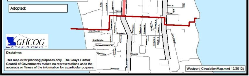
Comprehensive Plan Review and Update 2019

     The City of Westport Planning Commission began their review of the draft update to the 2013
     Comprehensive Plan that was put together in conjunction with the University of Washington
     Department of Urban Design in Planning in November 2019. This draft update was developed after an
     extensive year long partnership between the City of Westport and the University of Washington. The
     primary focus of this update was to integrate hazard mitigation strategies based on the Grays Harbor
     County Multi-Jurisdictional Hazard Mitigation Plan 2018 Update; Westport Annex. This was achieved
     through extensive analysis of the Grays Harbor County Hazard Mitigation Plan, community outreach in
     the form of multiple city staff and general public open houses, meetings, and workshops, and analysis of
     case studies of hazard mitigation integration

     Since the completion of the tsunami vertical evacuation building at Ocosta Elementary School in 2016 the
     Westport City Council and the community has expressed interest in further planning for community
     resilience against natural disasters. In response to this a collaboration proposal was sent to Westport City
     Council from Prof. Abramson from the University of Washington Department of Urban Design and
     Planning in July 2018. The collaboration proposal was also sent to the Westport Tsunami Safety Committee
     in August 2018. A memorandum of understanding was signed by Mayor Bearden and Prof. Abramson on
     September 5th, 2018. From there the University of Washington Urban Design & Planning studio team began
     work in October 2018 on developing recommendations for the update of the City of Westport
     Comprehensive Plan.

     The process for developing the recommendations included a great amount of community outreach and
     collaboration with City of Westport staff. This began with a public forum in September 2018, with visiting
     faculty and students from the University of XXX in XXX, Japan on the 2011 earthquake and tsunami. In
     October the studio team visited Westport and met with City staff and visit several locations in Westport. On
     November 5th, 2018, a virtual meeting was held to review hazard scenarios to be presented to the public and
     discuss the forthcoming public meeting. On November 16th, 2018 the first workshops was hosted at
     McCausland Hall in Westport. The workshop was a closed workshop for partners in the project and City
     staff and used WeTable as a platform to gather information. The second workshop with open to members of
     the public and was hosted at Ocosta Elementary School the following day.

     Following the partners and public workshops in late November, 2018 the studio group returned to Seattle to
     regroup and analyze the data collected from the workshops. This data was collated and presented in the form
     of a group report, power point presentation, and individual posters for each element of the City of Westport
     Comprehensive Plan. This was presented to the steering committee of the project at McCausland Hall on
     December 7th, 2018. The following day the posters were presented to the public at a public open house at the
     Tackle Box in downtown Westport.

     In the year since the final public engagement activity members of the studio team have been working to
     finalize the draft report of the recommendations for the City of Westport’s Comprehensive Plan Update.
     This report has served as the basis for the update to the Comprehensive Plan. The draft recommended
     updates for the Comprehensive Plan were sent to the planning board on November 19th, 2019 for discussion
     at the planning board meeting on November 20th, 2019. Prof Abramson presented the draft Comprehensive
     Plan update during this meeting and took part in the discussion and question and answers session that
     followed.

     It was agreed that further time was needed for members of the committee to provide comment on the
     proposed updates.

City of Westport Comprehensive Plan, 2020 Revision – Draft January 13, 2020                                     vi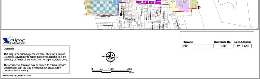
Following the initial review by the City of Westport Planning Commission (insert text based on next
     steps in Comprehensive Plan Update, 2019)

     The schedule of meetings that were held is listed in Table 1 and the Commissioners and review
     committee are listed below:

          n     Commission members involved in the review and update of this plan included Chair William
                Leraas, , members Rose Jensen, Jim Mankin, Jeff Pence and George Prigmore. City Staff
                involved in the review and update included Public Works Director/City Administrator Kevin
                Goodrich, Secretary Michelle Gooch

          TABLE 1
            LEGISLATIVE BODY                                    DATE            TIME            Meeting
                                                                                                Type

              Planning Comm
              Planning Comm
              Planning Comm
              Planning Comm
              Planning Comm
              Planning Comm
              Planning Comm
              Planning Comm
              Planning Comm
              Planning Comm
              Planning Comm
              Planning Comm
              Planning Comm
              Planning Comm
              Planning Comm
              Planning Comm
              Planning Comm
              Planning Comm
              Council
              Council

     PLANNING PROCESS, PUBLIC INVOLVEMENT AND LEGISLATIVE ADOPTION

     In accordance with the Revised Code of Washington (RCW) 35A.63.070 through 35A.63.073 the
     process for approving any comprehensive plan amendments are as follows:

          RCW 35A.63.070
          After preparing the comprehensive plan, or successive parts thereof, as the case may be, the
          planning agency shall hold at least one public hearing on the comprehensive plan or successive part.
          Notice of the time, place, and purpose of such public hearing shall be given as provided by
          ordinance and including at least one publication in a newspaper of general circulation delivered in
          the code city and in the official gazette, if any, of the code city, at least ten days prior to the date of
          the hearing. Continued hearings may be held at the discretion of the planning agency but no
          additional notices need be published.

City of Westport Comprehensive Plan, 2020 Revision – Draft January 13, 2020                                             vii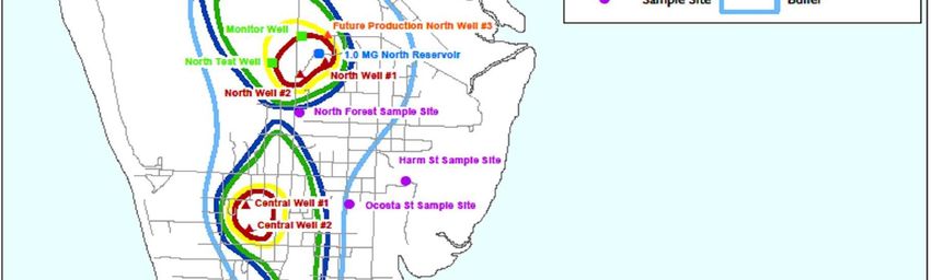
RCW 35A.63.071
          Upon completion of the hearing or hearings on the comprehensive plan or successive parts thereof,
          the planning agency, after making such changes as it deems necessary following such hearing, shall
          transmit a copy of its recommendations for the comprehensive plan, or successive parts thereof, to
          the legislative body through the chief administrative officer, who shall acknowledge receipt thereof
          and direct the clerk to certify thereon the date of receipt.

          RCW 35A.63.072
          Within sixty days from its receipt of the recommendation for the comprehensive plan, as above set
          forth, the legislative body at a public meeting shall consider the same. The legislative body within
          such period as it may by ordinance provide, shall vote to approve or disapprove or to modify and
          approve, as modified, the comprehensive plan or to refer it back to the planning agency for further
          proceedings, in which case the legislative body shall specify the time within which the planning
          agency shall report back to the legislative body its findings and recommendations on the matters
          referred to it. The final form and content of the comprehensive plan shall be determined by the
          legislative body. An affirmative vote of not less than a majority of total members of the legislative
          body shall be required for adoption of a resolution to approve the plan or its parts. The
          comprehensive plan, or its successive parts, as approved by the legislative body, shall be filed with
          an appropriate official of the code city and shall be available for public inspection.

          RCW 35.63.073
          All amendments, modifications, or alterations in the comprehensive plan or any part thereof shall be
          processed in the same manner as set forth in RCW 35A.63.070 through 35A.63.072.

     In addition, after the approval by the legislative body, the plan must be provided to the County
     Assessor’s office according to the following:

          RCW 35A.63.260
          By July 31, 1997, a code city planning under RCW 36.70A.040 shall provide to the county assessor
          a copy of the code city's comprehensive plan and development regulations in effect on July 1st of
          that year and shall thereafter provide any amendments to the plan and regulations that were adopted
          before July 31st of each following year.

City of Westport Comprehensive Plan, 2020 Revision – Draft January 13, 2020                                       viii
CHAPTER 1

 INTRODUCTION
A comprehensive plan is the basic foundation for local planning. It lays out a community vision and
priorities and describes where, how, and in some cases when development will occur. It is adopted by
the city as flexible guidelines for policymakers, land managers, and land users about how to conserve,
rehabilitate, or develop an area while addressing land use, housing, capital facilities planning, utilities,
rural development, transportation, economic development, parks and open space, urban design,
shoreline master programming, and utilitiesports.

The City of Westport Comprehensive Plan represents the official statement by the city council to be
used as a policy guide for the physical, economic and social development of the city. The
comprehensive plan establishes goals, objectives, and policies for the city upon which future decisions
should be evaluated. Among other items, the comprehensive plan should be seen as policy, that is, the
communication of the long- term values and aspirations.

A. AUTHORITY

Washington State Law (RCW 35A.63.061) requires that a comprehensive plan with an element
addressing land use and an element addressing circulation be required for every municipal code city.
Chapter 2.24.030 (2) of the Westport Municipal Code states “The planning commission may prepare a
comprehensive plan for the physical and other generally advantageous development of the town.” This
comprehensive plan functions as the guide to decision making in accordance with the requirements of the
state law and municipal code.

B. RELATIONSHIP TO THE 2013 COMPREHENSIVE PLAN UPDATE

This plan reflects an update of the 2013 plan that has guided growth and development in the city for
over the last decade. Comprehensive plans are designed to account for a planning horizon of around 20
years and are periodically updated.

This plan update was initiated by the need for Westport to plan for a safe and resilient future against
natural hazards – especially the hazards identified as high priorities in the Westport Annex of the Grays
Harbor County Hazard Mitigation Plan: earthquakes, tsunamis, erosion, and flooding. A major
milestone towards creating a safer and more resilient community to natural hazards was achieved in
2016 when Westport-South Beach became the first community in North America to build a tsunami
vertical evacuation structure (at the Ocosta Elementary School). This achievement serves as a key driver
for the plan update, which aims to ensure that hazard mitigation planning, conventionally done at the
county level, is adequately localized to suit community conditions and harmonized with city-level
comprehensive planning. While much of the content of this plan is the same or similar to the 2013
update, there have been significant changes to incorporate further hazard mitigation strategies into each
element’s goals, objectives and policies, to bring the plan in line with current conditions, and to update
the vision for the City’s future.

C. CHARACTERISTICS OF THE COMPREHENSIVE PLAN:

The comprehensive plan has four general characteristics:
(1) Comprehensiveness, (2) Long Range, (3) Flexibility, and (4) Community Participation and Input.

1.    Comprehensiveness
                                                                                                               1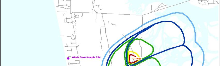
A comprehensive plan, by definition, should be comprehensive in both scope and purpose. The plan
should coordinate policy on those geographical and functional elements which have a bearing on
physical, social, and economic development.

2.    Long Range

Another characteristic of a comprehensive plan is that it is long rangelong-range and future- oriented. It
should look towards advancing the community beyond the immediate, to those concerns and
possibilities 15 to 20 years in the future. In effect, the comprehensive plan is a long rangelong-range
guide to current, short-range decisions.

3.    Flexibility

Because of the long rangelong-range characteristic of the comprehensive plan, it should also be flexible
and general to accommodate shifts in community preferences. The comprehensive plan is also flexible
and general in that it only summarizes major policies and does not in itself establish detailed regulatory
conditions. The comprehensive plan, however, should not be so general as to lack meaningful direction
or guidance to future decision-making.

4.    Community Participation and Input

The purpose of the comprehensive plan is not for the elected or appointed officials to tell the citizens
what the long termlong-term vision is for the development of the city, but to capture the citizens’
collective vision and implement it. It is essential that all aspects of the planning, development, and
implementation of the comprehensive plan and all associated policies and actions actively seek and
incorporate citizen participation and input.

D. PURPOSE

The purpose of the Comprehensive Plan is to provide a framework for guiding growth, development,
and public decision-making within the City. The Comprehensive Plan is intended to serve a wide range
of functions and purposes. The most critical of these are as follows:

1.    General Welfare

The Comprehensive Plan serves to promote the general health, safety, welfare, and morals of the
community. It does this by establishing guidelines for development and facilitating the adequate
provision of public services.

2.    Coordination

The Comprehensive Plan promotes and encourages rational, efficient, and coordinated developmental
decision-making. Conversely, the comprehensive plan discourages piecemeal, incremental zoning, and
subdivision actions. As a planning instrument, the Comprehensive Plan encourages anticipation rather
than reaction, and coordination rather than competition. The Comprehensive Plan therefore anticipates
and influences the coordinated development of land and buildings.

3.    Policy Statement

                                                                                                             2
The Comprehensive Plan also serves as the basis for municipal policy on development, and provides
those guiding principles, objectives, and techniques upon which the development of regulations can be
assessed and evaluated. The comprehensive plan, then, represents a long rangelong-range policy
statement by the city.
4. Communication
The Comprehensive Plan, as a statement of policy, represents the communication of values within the
community. This communication provides all interested parties, whether other public institutions,
private developers, businesses, and financial institutions with a general indication of the long rangelong-
range direction the legislative body has established for the community.
E. DEFINITIONS
In the context of this plan document, certain words take on more specific and more definite meanings.
The following words are defined so that the reader of this plan may more exactly understand its intent.
1. May, Should, and Shall
a. May: indicates that some action might be undertaken if the official body, after
viewing the evidence, decides it is useful or desirable in keeping with
this plan. It does not, however, confer any obligation upon the city to
undertake, approve, or permit the action.
b. Should: indicates that a particular action will take place unless the official body
finds a compelling reason against it.
c. Shall: indicates a mandate, i.e., the particular action must be done.
2. Goals, Objectives, Policies
a. Goals: are the general statements outlining the desired long-term future state
towards which the plan aims.
b. Objectives: are the statements of the desired short-term aims of the plan, which
reinforce and lend to the goals; the objectives should be taken to be more
specific, clearly defined conditions which must be attained in order to
accomplish the stated goals.
c. Policies: outline and describe general directions for governmental action, both
legislative and administrative, which would implement the preceding
goals and objectives.
3. Appropriate: Refers to those actions, policies, locations, and other decisions which are
in conformance with this plan.
F. IMPLEMENTATION
The success of this Comprehensive Plan will depend upon the City's commitment towards
implementation. Specific steps which the city should take following adoption of the comprehensive plan
3are defined more fully in Chapter 11. Nonetheless, at the outset, it is important to emphasize that
successful planning requires a continual, on-going process.
The successful implementation of this document will require continual monitoring of the citizen's needs
and goals, the development or revision of necessary land use regulations to bring them in conformance
with the goals of this plan, and the consistent referencing of this document whenever the legislative
body engages in the decision-making process impacting the physical development of the city.
4CHAPTER 2
PLAN ORGANIZATION
Given the previous discussion on the background and nature of the Comprehensive Plan, this chapter
proceeds to outline in narrative form the content of this comprehensive plan document. While each
chapter is prefaced with an introductory discussion, this chapter is intended to establish a setting of this
plan's structure and content.
In general, Chapter 1 and this chapter establish the basic framework for this Comprehensive Plan
document. These two chapters discuss the plan's need, intent, purpose, and content. As such, these
chapters form the background and setting for the subsequent chapters.
The following eight chapters (3-10) specifically address goals, objectives, and policies of the City and, in
doing so, represent the central point of reference in this plan. These chapters address specific functional
areas which are either required by state law, or which the city has exercised the option to address due to
their recognized importance to the community. The final chapter, Chapter 11, discusses the
implementation of this plan. Chapter 11 offers recommendations and guidelines for the effective
implementation of the goals, objectives, and policies established in the previous chapters.
The following provides a brief summary of each of the remaining chapters' contents.
Chapter 3: Chapter 3 contains the Comprehensive Plan's overall goals and objectives. These overall
goals and objectives represent those thematic concerns and issues which pervade the development and
rationale of the more specific, functional elements addressed in subsequent chapters.
Chapter 4: Chapter 4 is the Land Use Element which designates the general long termlong-term
distribution, location, and intensity of land use for the city. This chapter is divided into two components:
Goals and Objectives, and the Land Use Plan Map with Designations.
Goals and Objectives: This component of the land use element establishes goals, objectives, and
policies for general land use classifications and categories (e.g. residential, commercial).
These goals establish the guiding principles for these general land use designations. In
addition, beyond establishing goals, objectives, and policies for land use classifications, this
section also defines goals, objectives, and policies for the city relating to ground water
protection as well as for storm water drainage considerations.
Land Use Plan Map and Designations: This section of the land use element proceeds to apply
various land use designations to locations within the city. Thus, a comprehensive land use
map (Appendix A) showing the long rangelong-range intended land use of the City is
developed in this part of the plan. For each land use designation, there is a narrative
discussion on its purpose, examples of intended uses, and appropriate locations within the
city.
Chapter 5: This chapter is the Transportation, Circulation, and Telecommunications Element which
meets circulation planning requirements as required by state law. This element identifies the City's
circulation goals, objectives, and policies, and also provides a map describing the general alignment,
location, and extent of existing and proposed transportation routes. Because of the direct relationship
between circulation improvements and land use development, this element should particularly be
5coordinated with the land use element. As a new feature in the 2019 Comprehensive Plan Update,
Telecommunication is added to this Element because it is increasingly linked with transportation. Many
of the services and activities that conventionally involve movement of goods and people may be
replaced, augmented, or stimulated by use of telecommunications infrastructure. These services include
broadband, cellular, satellite, radio and other wireless transmission, and all their related voice, message,
and other data applications.
Chapter 6: Chapter 6 is the Economic Development Element. After several years of stagnation and
decline in growth during the end of the last decade, the last several years have seen a sharp decline in
the Westport economy as well as that of the surrounding Grays Harbor County region. The need to
establish goals and objectives that will enable the City of Westport to continue to support and retain its
current businesses while also continuing to attract new businesses to the area is evident. Encouraging
redevelopment as a means of improving the environment and diversity of the economy while preserving
important undeveloped areas and ecosystem services should be a high priority. Being an optional
element incorporated to this comprehensive plan, its inclusion indicates the City's recognized desire to
address economic development within the long rangelong-range comprehensive framework.
Chapter 7: Chapter 7 is the Community Identity and Natural Resource Element. Formerly called
“Community Appearance and Natural Resource,” the title of this Element is updated to address a
broader and more basic set of concerns than appearance only. This element generally addresses the
physical appearance of the City, both developed and undeveloped, but also some intangible and non-
visual aspects of the community’s identity, including its historic heritage and functioning natural
ecology, and the way the environment supports social activities. Although perhaps not immediately
evident, this element is related to the economic development element. Since the physical appearance,
mental image, and values of the developed and undeveloped environment is closely tied to the City's
appeal as a tourist oriented destination, it is important to address these aspects of identity as an element
to this plan. The betterment of the physical environment, then, is seen as one major way of furthering
economic development of the city. It is also important to properly manage the balance of developed and
undeveloped areas to meet state and federal requirements, provide adequate protection for the functions
and values of the undeveloped area and allow adequate area for development to provide for a healthy
economy.
Chapter 8: Chapter 8 is the Area-Wide Development Element. This chapter provides goals, objectives,
and policies intended to address the City's impact on the development pattern outside of the city limits,
particularly directly to the south. These goals and objectives relate especially to the impact that may be
placed upon the provision of public facilities as well as on the local tax base from development beyond
the city limits. This Element also addresses the need to coordinate City services with the regional
services that it enjoys, including transportation, the Ocosta School District, and the South Beach
Regional Fire Authority, as well as certain economic and environmental benefits outside the city limits
that are essential to Westport’s well-being.
Chapter 9: Discusses the approved Shorelines Master Plan for the City. A copy of the current Shoreline
Master Program is included as Appendix C. The master program is required by law to be in
conformance with the State’s Shoreline Management Act. Any proposed changes are required to be
reviewed and approved by the Department of Ecology prior to implementation. The shoreline
regulations are included with other zoning requirements in Title 17 of the Westport Municipal Code,
and the shoreline goals and policies have been re-located with other goals and policies in this
comprehensive plan. This chapter shall be updated in accordance with the schedule for master plan
updates established by the legislature.
Chapter 10: Chapter 10 is the Health and Well-Being Element. This entirely new chapter is an
opportunity to assess and plan for the health and well-being needs of the community. Prior to this
6update close attention had not been given to health needs such as access to primary health care
providers and as such planning opportunities for health and well-being were not fully explored. This
chapter includes goals, objectives, and policies for addressing and planning for the health and well-
being needs of the City’s future.
Chapter 11: The final chapter of this document is, perhaps, the most important. This chapter addresses
the implementation of this comprehensive plan and provides guidelines for the application of the goals,
objectives, and policies established within this plan. Chapter 11 discusses processes for maintaining the
timelines of the document, as well as on how regulatory devices should be maintained so as to best
implement this comprehensive plan.
7CHAPTER 3
OVERALL GOALS AND OBJECTIVES
Introduction:
The goals and objectives presented in this section represent the identified fundamental concerns and
hopes of the community. It is these overall goals and objectives that should be interpreted as being the
basis for the individual elements discussed in the following chapters. As such, these goals and objectives
can be interpreted as the common themes pervading through the rest of this document, as well as
presenting a foundation for individual goals, objectives, and policies within each of the following
comprehensive plan elements.
GOALS:
An aesthetically pleasing and visually stimulating city, carefully integrated with the other
functional elements of the physical environment.
To provide for projected increases in population and to encourage the retention and
expansion in the character and level of the fisheries, tourism, boat building and maintenance,
and other sectors of the Westport economy in an orderly yet flexible manner while protecting
the unique seaside character of this fishing community and environmental amenities of the
area.
To continue to promote Westport as a year- round destination for both tourism and other
forms of business activity.
To position Westport to take advantage of emerging science, technological advancements,
and planning improvements to create sustainable development that creatively reduces or
eliminates conflicts between different classifications of uses, reduces impacts to the natural
environment with the least possible impacts to residents and businesses, and creates a
sustainable city for future generations.
To promote community resilience against natural disasters; build on the success of the
Ocosta School District in constructing the nation’s first purpose-built tsunami vertical
evacuation structure; plan for additional vertical evacuation structures within and outside the
city limits, and to ensure that such structures are well-integrated into the environment and
daily life of Westport, and work together as part of a comprehensive City-wide evacuation
system; and consider other strategies of land use that would enable the City to prepare for
disasters and adapt to environmental changes. Resilience is achieved by the community’s
adaptive capacity, which enables it to prepare for, withstand, recover, and maintain its
identity in the face of actual, anticipated, or even unexpected hazard occurrences and other
disturbances (www.epa.gov/smartgrowth; The National Academies, Disaster Resilience: A
National Imperative (2012); Holling and Gunderson, Panarchy: Understanding
Transformations in Human and Natural Systems, 2002.) Threats and hazards present long-term
risks to people and their property. Mitigation is risk management action taken to avoid, reduce, or
transfer those risks. By reducing the impact of disasters, mitigation supports protection and
prevention activities, eases response, and speeds recovery to create better prepared and more
resilient communities (FEMA National Mitigation Framework).
OBJECTIVES:
81. To preserve and reinforce the unique seaside character of Westport.
2. To encourage the development of housing of all types appropriate to the needs of the various
population groups within the city.
3. To work for the elimination of the effects of discrimination in housing based on race, color,
religion, sex, or national origin and to provide safeguards for the future against such
discrimination.
4. To foster cooperation and understanding between the City of Westport and other local, county,
state, and federal governmental entities and agencies of the City’s unique environment, both
physical and economic to provide for a stable and growing economic base. To encourage
cooperation between the city and other agencies in the development of a stable and growing
economic base.
5. To protect the environmental amenities of the area to the extent that the attractiveness of
Westport to tourists and the quality of life for residents is maintained and/or enhanced.
6. To expand Westport’s effective market for commercial services in the South Beach area.
7. To develop policies, programs, and processes which will further the general health, safety,
and welfare.
8. To maintain and enhance the character of Westport’s quality natural and physical environment
and limited land area in a manner that provides for adequate protection without unnecessarily
impacting the social, economic, and physical development of Westport.
9. To manage future growth and development in a manner that supports existing developments
while providing for future growth and diversification of Westport’s economy.
10. To develop a circulation system which serves all areas of the city and all users in the most
economical, efficient, and compatible manner possible.
11. To develop policies, programs, and processes that ensure that new development providesd
adequate mitigation offor impacts to infrastructure and services to prevent burdening existing
residents with increased costs or reduced services.
12. To develop policies, programs, and processes that retain current businesses, attract new
development, encourage redevelopment of existing properties, and develop infrastructure and
amenities as a means to promote Westport as a year round destination.
13. To develop policies, programs, and processes that encourage hazard mitigation strategies to
be incorporated into development and redevelopment to make Westport a safer and more
resilient community against natural hazards.
14. To creatively apply best available science and technologies to prevent the set aside of large
tracts of land as open space.
9CHAPTER 4
LAND USE ELEMENT
Introduction:
A balanced land use pattern prevents sprawl, preserves and enhances residential neighborhoods,
provides adequate open spaces, protects environmentally sensitive areas, protects people and property
from environmental hazards, promotes economic development, and encourages community
redevelopment at appropriate locations, resulting in a high quality physical environment for residents,
workers, and visitors.
The land use element is probably the most important as it ultimately allocates and guides the desired
distribution of land use over the length of this comprehensive plan. It describes how the goals of the
other plan elements will be implemented through land use policies and regulations and describes the
development goals for a 20 year period. Decisions on matters concerning subsequent elements should be
reviewed for their consistency with the land use element. Furthermore, land use actions such as rezones,
variances, and conditional uses should also be made with reference to their conformance with the goals,
objectives, and policies of this element.
Consideration of existing land use patterns is necessary for a general understanding of the area and, at a
more specific level, of the area’s capabilities and possible sites for development. Where existing land
use patterns are desirable and long-standing, it is appropriate for the comprehensive plan to provide for
their continuation. Where new or projected needs or conditions and community desires indicate that a
change in pattern should occur, the plan should provide for such change over time. For areas as yet
undeveloped within or adjacent to the city, the plan should anticipate and guide their development
consistent with the public interest, physical limitation of the land, and capacity of public services and
facilities.
The land use element is also an important element as it contains many hazard mitigation strategies that
create involve stand alone goals, objectives and policies but also guide and overlap with hazard
mitigation strategies in subsequent elements. This element will focus on how land use decisions can
build resilience to natural hazards, in particular those with the highest risk of occurrence in Westport
that can be addressed with land use decisions, specifically tsunamis, earthquakes, and sea level rise.
As noted in Chapter 2, this land use element is presented in two parts. Sections A through I are general,
and serve to establish the land use goals and objectives for broad land use classifications e.g. residential,
commercial, and industrial. They also establish general policies to be used in the development of
implementing ordinances. Furthermore, as required by state law for the land use element, provisions are
included to assist the City in the protection of the quality and quantity of ground water supplies; there is
also a similar review of stormwater and drainage related concerns.
Section I of this land use element is a discussion of the land use plan map and designations. This section
is preceded with a more detailed explanatory discussion of its content. For now, however, the general
purpose of this section is to specifically allocate space for various land use designations throughout the
city. In addition, each land use designation contains a policy-oriented discussion of its purpose,
description, and appropriate locations.
10Finally, the land use element must be especially coordinated with the implementing ordinances, that is,
primarily the zoning and subdivision ordinances of the city. Such coordination is discussed and
presented in more detail in Chapter 10 – Implementation.
A. OVERALL GOALS AND OBJECTIVES
General
Over the last two decades, Westport has seen several transitions, initially from an industrial economy
focused on logging and commercial fishing, to a more diverse economy with strong seafood processing
and yacht building industries coupled with a tourism and recreational activity based economy. Westport
is also home to a large number of military personnel and their families, both active duty and retired.
During the early 2000s, Westport was “discovered” and several large developments were proposed and
some were completed. Although the severe economic conditions of the late 2007 to mid 2009 has
delayed and possibly even ended some of these proposals, the economy has showed signs of turning
recovery. In recent years several new businesses opened in Westport including new tourist
accommodations types including cottages and hostel rooms, tourist souvenir and boutique stores, and
new restaurants helping Westport become a more year-round destination for visitors and a more livable
community for residents. During the last decade Westport has also shown great interest in building
community resilience against natural disaster with the construction of the first vertical evacuation
structure at Ocosta Elementary School and a continued community interest in further persuing additional
vertical evacuation structures and other means to build a more resilient city. The goals and objectives
included in the sections of this chapter are intended to position Westport to continue to take advantage
of the economy as it recovers and allow for continued growth in a safe environment.
GOALS:
To promote the establishment of appropriate population densities and concentration that will
contribute to the well being of persons, the city, and the preservation of the environment.
To promote an efficient and orderly pattern of land use which protects the unique seaside
character of Westport, its environmental amenities, and the integrity of its residential
neighborhoods while providing a flexible approach to the development of commercial and
industrial lands.
To promote new development and redevelopment strategies that incorporate hazard
mitigation planning techniques to build a safer and more resilient community.
OBJECTIVES:
1. To plan for a projected population of 3,200 in the city of Westport, and a projected
population of 4,100 for the Westport area by the year 2030.
2. To provide efficient land in suitable locations for the various uses needed to meet the
demands of expected population increases and an expanded and stable economy.
3. To minimize land use conflicts and encourage compatibility between land uses through
careful and attractive design and the use of appropriate open space.
4. Encourage the redevelopment of underutilized or dilapidated properties and areas.
115. To prevent overcrowding of land use in the city, thus providing for adequate air, light, and
protection from fire and noise pollution.
6. To apply appropriate planning principles and techniques to guide the physical development
of the city.
7. Maximize the opportunities provided by Westport’s unique seaside character.
8. Encourage development in areas on higher, stable ground to mitigate against impacts of
natural hazards such as sea level rise and earthquakes/tsunamis.
9. Investigate climate resilient building code opportunities using best available science to
ensure new development is enhances the long lastingsustainability of the community, and is
resilient to the impacts of climate change and sea level rise, or at least accounts for the
cumulative impacts of sea level rise.
10. Encourage the construction of multi-use vertical evacuation structures by both in the public
and private sectors that can be used both as places of refuge during an emergency event, and
also for economic or social activities on a regular basis.
B. RESIDENTIAL LAND USE
Over the last decade, several new residential developments were permitted and/or completed within the
city. These developments created the first traditional condominium style developments and proposed the
development of small cottage style homes for lower income families. Change in state laws required that
Westport allow Manufactured Homes in all zoning districts. Westport has always been a destination for
the development of private vacation homes. The downturn in the economy created an increase in the
number of residences that were turned into commercial vacation rentals and an increase in commercial
home occupations in the residential areas. The city does not want to discourage these commercial uses
but wants to ensure the impacts of them on traditional residences and neighborhoods are eliminated
where possible.
Based on these trends, the types of multi-family residential developments has increased to include
multiple units on a single parcel and combined units with between two and four units per building.
These developments may include single family residences, condominium developments, and townhouse
developments. The previous comprehensive plan created four land use classifications with varied
standards to create a matrix of higher and lower densities and restrictions to provide adequate space for
all types of residential development. Those original classifications are still adequate and appropriate.
The following goals and objectives are intended to continue the mix of residential development while
providing for the growing interest in commercial uses that are consistent with residential areas.
GOALS:
To provide sufficient space, protected from conflicting uses, and where possible adverse
impacts of natural hazards, for various residential uses, rent levels and property values while
maintaining, to the extent possible, traditional residential cultural values.
To increase the City’s stock of affordable housing.
OBJECTIVES:
121. To separate various types of single-family structures including new-designated manufactured
homes in order to optimize choice in neighborhood type.
2. To allow new multiple-family structures within designated residential areas, provided the
resulting density does not exceed eighteen (18) units per acre and provided each development
is reviewed to insure compatibility with surrounding single-family residences. Denser
development should be prioritized on higher ground, where tsunami hazards are least severe,
and include housing affordable to families and residents in particular need.
3. To protect residential neighborhoods from the intrusion of incompatible commercial and
non-residential land uses and prevent disruptive non-residential traffic.
4. Maximize the availability of view property.
5. To provide nearby pedestrian access to and encourage development of neighborhood parks
and limited commercial services directly appurtenant to residential lifestyles within
residential zones. Parks should be considered as places of gathering and refuge in an
emergency, including storage of supplies accessible in an emergency, and integrated with
tsunami vertical evacuation structures where appropriate.
6. Minimize new residential development and redevelopment in areas prone to damage from
tsunami inundation, sea level rise and flooding, except where new construction does not
increase overall residential densities in those areas and provides opportunities for vertical
evacuation (see Objective 7).
7. Encourage multi-story residential buildings, including mid-rise condominiums, to have
public rooftop access during emergency events such as severe flooding and tsunamis. Review
the possibility of applying additional funds to design and construct such buildings as
earthquake- and tsunami-resistant vertical evacuation structures, according to the best
available scientific models of ground motion, liquefaction, and tsunami impacts, and
according to guidelines approved by the National Tsunami Hazard Mitigation Program.
C. COMMERCIAL LAND USE
The last century has seen significant swings in commercial activities and trends created primarily from
the economy. The early 2000s began with a commercial base focused primarily on fishing, both
recreational and commercial. Most small businesses, including the lodging and retail segments, catered
to the seasonal recreational fishing that attracted most of the visitors to Westport. When the national
economy boomed, large commercial developments were proposed that included a golf course,
convention center, and motels. A secondary effect was an increase in proposed expansions,
redevelopment, and infill developments focused primarily in the Marina District. When the economy
crashed, so did most of the proposed developments. Westport needs to be positioned to take advantage
of the recovering economy to allow for the completion of the destination resort that was identified in the
first comprehensive plan as a priority.
The attraction of Westport has expanded and diversified to include surfing, storm watching, the
lighthouse, the maritime museum, and all of the natural beauty and wildlife that surrounds Westport.
New commercial activities have moved to Westport including wineries and breweries, and businesses
that cater to the expanding types of tourists. Westport is working to expand the tourism industry from
seasonal to a year round industry. Additionally there is still a growing need for small businesses that
focus on the needs of residences. Four classes of mixed use tourist commercial districts are intended to
13provide for these diverse needs. The City will need to continue to monitor the allowed uses in the zoning
code to keep up with new and emerging uses and trends such as electric vehicles and recycling. With an
increased awareness in the local community on safety and resiliency in natural hazards communicating
this information and ensuring tourist populations and other business patrons are safe during hazard
events is also necessary in commercial development. The following goals and objectives are intended to
continue the expansion of commercial development within the city with a focus on a year round
economy, while retaining the current traditional businesses.
GOALS:
To provide adequate areas, both in size and location, for commercial activities which will
serve the present and future needs of the fisheries and tourism industries and local residents.
To encourage commercial development designed and located so that it is economically
feasible to operate, where public services exist or can be provided in an economical manner,
and that provide goods and services in a safe, convenient, and attractive manner.
Encourage commercial development and redevelopment that incorporates hazard mitigation
strategies in planning and construction.
OBJECTIVES:
1. To reinforce the basic character of the various commercial areas within Westport while
allowing flexibility in location of uses.
2. To allow development along main arterials of commercial uses compatible with adjoining
residential uses.
3. To encourage attractive and efficient commercial development, especially in the areas of
Westhaven that serve tourists.
4. To provide sufficient area for the expansion of Westport’s effective market for commercial
services in the South Beach area in areas that are presently designated as commercial areas.
5. To provide for the development of suitable undeveloped areas in a manner that promotes
Westport as a tourism destination.
6. Areas immediately adjacent to the state highway should be designated to allow for a mixture
of residential and commercial development compatible with a commercial area.
7. The City should provide a full range of municipal services to meet the needs of expanding
and new businesses in appropriate locations and should identify the type and level of public
services appropriate to support future economic development.
8. Redevelopment in the Marina District, in particular the tourist commercial areas, should
include investment in resilient infrastructure such as floating docks and elevated/amphibious
infrastructure.
D. INDUSTRIAL LAND USE
Industrial development in Westport has always and continues to be centered around the marina district
and related fishing and boat building industries. These industries have weathered the downturn in the
14economy and have actually expanded over the last decade. Westport is home to the largest commercial
fishing fleet on the Washington Coast and headquarters of one of the largest luxury yacht manufacturers
in the nation. Westport needs to continue to focus on providing for the development of these industrial
bases. There is not currently significant area for additional expansion or new industrial developments.
The City will need to monitor this in the future to ensure it does not prevent future development, and
when future development is necessary best practice are used to ensure infrastructure is resilient to the
impacts of climate change. The City currently has one industrial zoning district. The allowed uses are
focused on the fishing, seafood processing, storage, and sales, and boat manufacturing, sales, repair,
both marine and land based shipping and trucking, and various other industrial activities related to the
marina.
GOALS:
To provide space for industrial uses and related activities, protected from other uses and
buffered from impacting other uses, which can benefit from Westport’s marine location and
encourages the continued development of marine-oriented uses.
OBJECTIVES:
1. To allow industrial development that will enable the City to diversify its economic base.
2. To allow industrial uses which minimize adverse impacts to the natural and human
environment, and which minimally, if at all, disrupt the character of the community.
3. Industrial uses should be grouped with similar uses in areas that limit land use conflicts,
improve traffic flow and safety, and allow businesses to share public facilities and services.
4. Industrial development and redevelopment should incorporate hazard mitigation measures to
reduce the adverse impacts resulting fromcreate more resilient infrastructure against natural
hazards such as storm surges, extreme tides, tsunami impacts, and sea level rise, and to
mitigateincluding environmental hazards due to flooding and tsunami impacts, includingsuch
as chemical spills, hazardous debris, and fires.
E. PUBLIC AND SEMI- PUBLIC LAND USE
Public and semi-public uses include infrastructure, utilities, facilities and services, whether public or
semi-public in nature. High quality public and semi-public uses are vital to the overall wellbeing of the
existing community and are critical factors in the City’s ability to respond to and recover from natural
and man-made disasters. It is therefore important to best protect public and semi-public critical facilities
during a natural disaster that are relied upon immediately after the event has occurred, including
especially first responders such as firefighting, ambulance, and police facilities. These same uses need to
have adequate capacity to encourage and facilitate future growth both in terms of new development and
redevelopment in the City.
GOALS:
To ensure that public facilities and services are high quality, fully maintained and cost
effective.
Pursue improvements in emergency preparedness, such as the development of tsunami
vertical evacuation structures which that provide mixed recreational or commercial uses
15during regular day-to-day activities, to better meet the health and safety needs of the city if an
emergency should occur.
To provide necessary facilities that can adequately serve development and future expansion
without negatively impacting existing levels of service.
To provide adequate space for the location of state and federal government facilities which
provide services to the community.
To ensure critical facilities are situated in areas least prone to impacts of natural disasters and
are accessible and functional immediately following an emergency event.
OBJECTIVES:
1. Define acceptable standards and prioritize funding for improvements to accommodate
development and future expansion.
2. Ensure that public and semi- public facilities meet all state, federal and local standards and
will accommodate future growth.
3. Encourage the design and development of infrastructure, utilities and facilities that will
survive, to the greatest extent practicable, anticipated natural disasters, and to provide places
of refuge to the public during a disaster and recovery services after it is over.
4. Encourage the use of parks and other appropriate open spaces as community gardens for
local food production.
5. Identify site-specific locations for construction of additional mixed-use vertical evacuation
structures, such as parking infrastructure that are is accessible to high numbers of Westport
residents and visitors.
6. Research and evaluate opportunities for relocation of public critical facilities such as
emergency services to higher ground within the city limits along the dune ridges or outside
the city limits on higher ground as a measure of protection against natural hazards such as sea
level rise and tsunamis.
7. Invest in infrastructure for critical facilities that is able to withstand the impacts of climate
change including extreme weather events, flooding, and natural disasters such as earthquakes
and their associated hazards: ground shaking, liquefaction, landslides, ground subsidence,
and tsunamis.
F. RECREATION
The recreational land use category includes a wide variety of uses including publicly and privately
owned properties and businesses. Many of these provide access to or take advantage of the natural
features of the area in and around the City of Westport. Public and privately owned facilities that
provide recreational and entertainment opportunities, cultural and historic preservation, display and
performance of the arts and other similar uses that enhance the vitality of the community are included in
this land use category.
GOALS:
16To maintain and develop a high-quality system of parks, trails, and public access that
preserves and enhances the public’s access to and enjoyment of the significant environmental
resources located in and around the city.
To encourage the preservation and public enjoyment of historical features located within the
city.
To encourage the development of businesses and properties with cultural, civic, and historic
preservation uses to improve the sense of community in the City of Westport.
OBJECTIVES
1. To provide high quality, low maintenance, convenient and accessible park and recreational
facilities for all segments of the population and visitors to the city.
2. To encourage the development of recreational facilities, both passive and active that provide
increased access and improved health for the citizens of Westport and attract visitors.
3. Provide and maintain trails to and along the ridgelines that can be reached for access to
higher ground during emergency events such as a tsunami.
G. LAND USE POLICIES
1. The city should encourage the provision of affordable housing to accommodate for changing
demographics among the growing young and elderly populations in Westport. Units should
be designed so as to integrate compatibly with the area, as well as be designed to instill pride
among its residents.
2. As mandated by legislative action taken in 2005, the City shall consider New- Designated
Manufactured housing to be sited in any zone where a site-built single- family dwelling is
permitted under Westport Municipal Code and in compliance with state law. Mobile homes
are no longer built and may only be placed in mobile home parks in existence prior to July 1,
2005 in accordance with Westport Municipal Code 17.20A.035 (1).
3. Multiple-family structures shall be considered within designated residential areas.
Environmental review of such projects should consider, at a minimum, access to the site,
including increased traffic volumes, and ingress and egress to the site, and the location and
design of parking, overall density in the immediate neighborhood, and the adequacy of public
facilities serving the site.
4. A commercial zone should be established within the City's zoning ordinance to foster a
mixed use zone serving commercial and tourist needs in the city. The commercial zone
should attempt to recognize the differing character of commercial activities in the city, such
as the community business district along Montesano Street and the tourist commercial area
along the Westhaven/City waterfront area. Provisions for any zone should balance the
maintenance and encouragement of the different character of these areas with the objective of
allowing the greatest amount of flexibility in location and diversity of uses.
5. Commercial uses may be allowed along existing and planned arterials and highways in the
older areas of the city, provided such uses are not large traffic generators, do not disturb
17You can also read